Ordinary
Council Meeting
To be held in the
Council Chamber
Whitehorse Civic Centre
379 Whitehorse Road Nunawading
on
Monday 26 June 2017
at 7.00pm
Members: Cr
Denise Massoud (Mayor), Cr Blair Barker, Cr Bill Bennett,
Cr Raylene Carr, Cr Prue Cutts, Cr Andrew Davenport,
Cr
Sharon Ellis, Cr Tina Liu, Cr Andrew Munroe,
Cr
Ben Stennett
Mr Jeff Green
Acting Chief Executive Officer
Ordinary Council Meeting 26
June 2017
AGENDA
1 PRAYER
1a Prayer
for Council
We give thanks, O God, for the Men and Women of the past whose
generous devotion to the common good has been the making of our City.
Grant that our own generation may build worthily on the foundations
they have laid.
Direct our minds that all we plan and determine, is for the
wellbeing of our City.
Amen.
1b Aboriginal
Reconciliation Statement
“In the spirit of reconciliation, Whitehorse City Council
acknowledges the Wurundjeri people as the traditional custodians of the land we
are meeting on. We pay our respects to their Elders past and present.”
2 WELCOME
AND APOLOGIES
3 DISCLOSURE
OF CONFLICT OF INTERESTS
4 CONFIRMATION
OF MINUTES OF PREVIOUS MEETINGS
Minutes of the Ordinary Council Meeting 15 May 2017
and Confidential Ordinary Council Meeting 15 May 2017
|
RECOMMENDATION
That the minutes of the Ordinary Council Meeting
15 May 2017 and Confidential Ordinary Council Meeting 15 May 2017 having been
circulated now be confirmed.
|
5 RESPONSES
TO QUESTIONS
Ordinary Council Meeting 26
June 2017
6 Notices
of Motion
6.1 Notice of Motion No 105 -
Cr Davenport
|
That Council:
A Having:
1. Considered all written submissions;
2. Heard the presentations of submissions;
3. Received the report of the Special
Committee (minutes extract Attachment A) of its meeting held on 13 June 2017;
and
4. Considered officer comments (as attached
Attachment B), now adopt the Proposed Budget 2017/18 inclusive of the
Strategic Resource Plan 2017-2021 (Attachment C) with the modifications at 5
in accordance with Section 130 of the Local Government Act 1989.
5. a) Parking Fee for
Council Car Parks at Cambridge Street, Harrow
Street and Ellingworth Pde be reduced to zero for
Saturday, and allow $5,000 for signage.
b) Box Hill
Mall Permits fee is increased 2.5% from 2016/2017 levels;
c) Cease
Fair Trade program;
d) Cease
Rebates for solar, water tanks, batteries etc;
e) Cease
Whitehorse Scholarship Program;
f) Cease
(3) Swing Pop Boom Concerts;
g) Cease
Built Environment Awards;
h) Cease
Business Newsletter;
I) Cease
Whitehorse Business Week;
B Thank
persons making submissions in writing for their contribution and advise them
of the outcome of Council’s decision.
C Authorise
the Chief Executive Officer to give public notice of Council’s decision
in accordance with Section 130(2) of the Local Government Act 1989 and submit
a copy of the budget to the Minister in accordance with Section 130(4) of the
Local Government Act 1989.
|
7 Petitions
8 Urgent
Business
Ordinary Council Meeting 26
June 2017
9 Council
Reports
9.1 City
Development
Strategic Planning
9.1.1 Amendment
C193 to the Whitehorse Planning Scheme - rezoning 289-291 Morack Road, Vermont
South
ATTACHMENT
SUMMARY
On 12 October 2016 Council
received a request to consider an amendment to the Whitehorse Planning Scheme
for the site at 289-291 Morack Road, Vermont South. The amendment seeks to:
· Rezone
the site from Commonwealth Land to part General Residential Zone and part
Neighbourhood Residential Zone;
· Rezone
part of the existing Urban Floodway Zone land to the General Residential Zone;
and
· Apply
the Environmental Audit Overlay and Design and Development Overlay (Schedule
10) to the land.
This report discusses the
amendment request and recommends that Council seek authorisation from the
Minister for Planning to prepare and exhibit Amendment C193 to the Whitehorse
Planning Scheme.
|
RECOMMENDATION
That Council as the Planning Authority, seek
authorisation from the Minister for Planning to prepare and exhibit an
amendment to the Whitehorse Planning Scheme in accordance with the documents
in Attachment 1 for the land at 289-291 Morack Road, Vermont South to:
i. Rezone
a part of the site that is currently designated as Commonwealth Land to the
Neighbourhood Residential Zone - Schedule 5;
ii. Rezone
a part of the site that is currently designated as Commonwealth Land to
General Residential Zone - Schedule 5;
iii. Rezone
a part of the existing Urban Floodway Zone land to the General Residential
Zone - Schedule 5;
iv. Introduce
and apply the Design and Development Overlay – Schedule 10 (DDO10); and
v. Apply
the Environmental Audit Overlay (EAO).
|
background
On behalf of Across Property
Developments Pty Ltd, Pro Urban (the proponent) has submitted a request to
Council to amend the Whitehorse Planning Scheme (Planning Scheme) by rezoning
land at 289-291 Morack Road, Vermont South (the site) from Commonwealth Land
(CA) to part General Residential Zone – Schedule 5 (GRZ5) and part
Neighbourhood Residential Zone – Schedule 5 (NRZ5).
The request also seeks to rezone a
part of the site that is currently located within the Urban Floodway Zone (UFZ)
to GRZ5 and introduce and apply Schedule 10 to the Design and Development
Overlay (DDO10) to the site. Finally, the request seeks to apply the
Environmental Audit Overlay (EAO) to the site.
History
Rates information indicates that
the site was purchased by the Commonwealth of Australia in June 1988 on behalf
of Telecom (now known as Telstra) for the construction of a telecommunication
tower. In the late 1980s, Telecom requested a rezoning of their parcel of land.
Following a Council resolution to rezone the site and agreement by the
landowner to the south fronting onto Burwood Highway to rezone their property,
the property to the south was consequently rezoned via a planning scheme
amendment, as per Council’s resolution, yet the subject site remained as
Commonwealth Land.
It is not known why the site was
not included in this rezoning. Rates information documents the site being sold
by the Commonwealth of Australia and purchased by the immediate past owners in
December 1993. A building permit was issued in November 1994 to convert the
existing building to a dwelling.
The previous owners sought to
rezone the site to a residential zone. As the site was sold by the Commonwealth
of Australia, and has been in private ownership for some time, it was
considered reasonable to rezone the site to a zone more reflective of its
ownership status, that is, not Commonwealth Land.
After extensive correspondence with
the previous owners, a strategic assessment of the site was conducted in late
2014, which concluded that a residential zone was the most appropriate zone for
the site. This was on the basis that the land had been used for residential
purposes for some time, and that it forms an interface between parkland and
commercial uses fronting Burwood Highway.
The zoning of the site was discussed
with the then Department of Transport, Planning and Local Infrastructure
(DTPLI). The Department’s legal team indicated that the title search was
sufficient to indicate that the site was no longer required for Commonwealth
purposes, and they indicated support for a residential zoning via a section
20(4) process.
The site was included in Whitehorse
Amendment C159 which proposed to correct various anomalies and errors
identified in the Planning Scheme. However, upon representations by the
landowners at the time, the site was removed from the Amendment by the
Department of Environment, Land, Water and Planning (DELWP) prior to the
approval of the Amendment. DELWP did not raise any concerns with rezoning the
site to a residential zone but advised that any rezoning, and any application
of overlays on the site, needs to proceed through a normal amendment process
with full exhibition and the consideration of any submissions by an independent
panel.
The site has subsequently changed
ownership. Council officers have had several meetings with the current owners
to determine an appropriate zone/s for the site prior to this amendment
request.
The site and surrounds (Refer
Figure 1)
The site has a total area of
11,582m2. The site has one vehicle crossover from Morack Road and
vehicle access is also available from Burwood Highway through the site to the
south. The site is currently occupied by a small building in the centre of the
site, which was used by the previous owners as a dwelling. Other smaller
buildings are located on the eastern portion of the site and a large part of
the site is covered by asphalt.
The site is bounded by Morack Road
to the west, Morack Public Golf Course to the north, Dandenong Creek to the
east and a storage facility and medical centre to the south. The land located
to the west across Morack Road is a residential area included in NRZ5 and
Neighbourhood Character Precinct - Garden Suburban Precinct 7.
The preferred character in Garden
Suburban Precinct 7 is contemporary dwellings sitting within larger lots,
comprising established gardens containing substantial vegetation. Any future
development that is close to the Dandenong Creek environs should be sited so
that the overall visibility of the development is minimised when viewed from
the creek corridor.
A row of trees is located along the
northern and southern boundaries and a stand of trees is located towards the
Morack Road frontage. The part of the site currently included in the UFZ also
contains vegetation.
Land uses in the immediate area
include Council’s Vermont South Recycling and Waste Transfer Centre, a
Motocross park and a commercial property on Burwood Highway with large
tenancies including Officeworks and Bunnings.
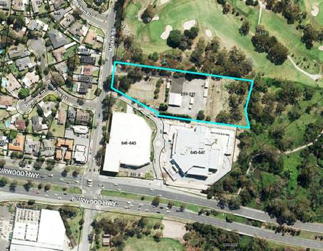
Figure 1 – Aerial photography of the site and
surrounding area
Current planning controls (Refer
Figures 2 and 3)
The subject site is currently
included as Commonwealth Land and is located outside the jurisdiction of the
Whitehorse Planning Scheme. The eastern third of the site is included in the
Urban Floodway Zone.
The site is partially covered by
the Special Building Overlay and Land Subject to Inundation Overlay.
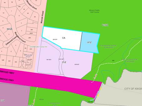
Figure 2 – Current zoning of the site and
surrounding area
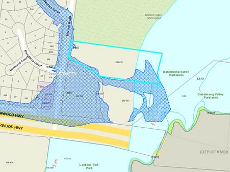
Figure 3 – Current overlays applicable to the
site and surrounding area
Proposal
As shown in Figure 4, and in the
documents in Attachment 1, the Amendment seeks to:
· Rezone
a part of the site that is currently located within Commonwealth Land to
Neighbourhood Residential Zone – Schedule 5;
· Rezone
a part of the site that is currently located within Commonwealth Land to
General Residential Zone - Schedule 5;
· Rezone
part of the existing Urban Floodway Zone to General Residential Zone –
Schedule 5;
· Introduce
and apply a Design and Development Overlay – Schedule 10 to the entire
site.
· Apply
an Environmental Audit Overlay to the site.
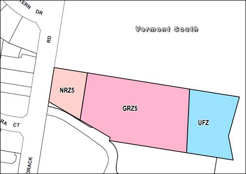
Figure 4 – Proposed zoning
Proposed Neighbourhood
Residential Zone – Schedule 5 (NRZ5)
The NRZ5 applies to the existing
residential properties along Morack Road to the west of the site. The existing
NRZ5 schedule proposed to be applied to the Morack Road frontage of the site
includes variations to the ResCode requirements which will direct outcomes for
any future development on this parcel. The maximum height allowed in NRZ5 is 2
storeys/9m at any point. The NRZ also requires a minimum garden area to be
provided.
The NRZ part of the site will front
Morack Road for the full width and with sufficient depth to allow for a single
row of dwellings facing Morack Road. Officers are therefore satisfied that this
part of the site proposed as NRZ is appropriate as it will require that any
future development on this portion to be of a scale, form and character that is
consistent with the surrounding area. This will respect the existing
neighbourhood character and respond to the site’s location in close
proximity to the Dandenong Creek environs.
Proposed General Residential
Zone – Schedule 5 (GRZ5)
The balance of the existing
Commonwealth Land, and part of the land currently zoned UFZ, is proposed to be
rezoned to GRZ5. The GRZ5 contains a blank schedule and currently applies to a
small number of sites in the municipality. These sites include part of the
former Burwood Brickworks in Burwood East, 15-31 Hay Street, Box Hill South,
1030 and 1048 Whitehorse Road, Box Hill and to several parcels included in the
Healesville Freeway Reservation in Vermont and Vermont South.
The GRZ5 does not include any
variations to the ResCode requirements in the Planning Scheme, therefore the
GRZ5 allows a maximum height of 3 storeys/11 m at any point. The GRZ also
requires a minimum garden area to be provided.
Clause 22.03 (Residential
Development) of the Planning Scheme states that new development in the form of
flats and apartments should only be located in Substantial Change areas, which
were largely translated to the Residential Growth Zone. Therefore apartments
will not be supported by Council on this site.
The extent of the rezoning of the
UFZ was informed by advice obtained by the proponent from Melbourne Water which
advised that it has no objection to moving the UFZ boundary and subsequent
rezoning of that part of the current UFZ. The realignment would effectively
move the boundary approximately 12m to the east of the existing boundary.
Melbourne Water have advised that
the moving of the UFZ line is approximately 1 metre below flood level, which is
the maximum flood depth that Melbourne Water considers suitable for allowing
filling for development.
When development proceeds the UFZ
line would be the limit of filling into the floodplain, and preference would be
for the filling to be done with a maintainable batter slope to the satisfaction
of Melbourne Water. No filling should extend onto neighbouring
properties. The existing UFZ boundary appears to line up with the brick
building, and is well above flood level for most of its length.
Council does not have any assets on
the site, as the pipes are owned and managed by Melbourne Water.
Council’s Engineering Assets Unit has not had any consultations with
Melbourne Water regarding this site; however they have advised that Melbourne
Water will ultimately make the decision regarding any rezoning of the UFZ land.
Officers are satisfied that the
proposed GRZ5 is appropriate for the site as it discourages apartment
developments and requires any future development to be cognisant of the
existing residential development and surrounding environs.
Proposed Design and Development
Overlay – Schedule 10 (DDO10)
The Amendment request proposes to
introduce a new schedule to the Design and Development Overlay and apply it to
the entire site. The proposed Schedule 10 to the DDO confirms design
objectives for the site, permit requirements and general requirements for built
form, site design and transition, and landscape and streetscape design.
The proposed Schedule also provides
guidance and responds to the interfaces with the Morack Golf Course and
Dandenong Creek environs. The proposed Schedule includes a suite of
decision guidelines to provide direction for any future planning permit applications
for the site.
Officers have held multiple
discussions with the proponent to ensure that the proposed DDO provided
appropriate controls for any future development on the site. Officers are
satisfied that the proposed DDO will provide appropriate direction for any
future built form and in particular, respect the existing neighbourhood
character and environs.
Proposed Environmental Audit
Overlay (EAO)
The EAO will ensure any future
sensitive use of the land will be suitably protected from potential contamination
resulting from any former uses of the site.
Under Clause 45.03-1 of the
Planning Scheme the application of the EAO requires that before any sensitive
use (such as a residential use, child care centre, pre-school centre or primacy
school) commences or before the works associated with a sensitive use commence,
either
· A
certificate of environmental audit must be issued for the land in accordance
with the Environment Protection Act 1970; or
· An
environmental auditor appointed under the Environment Protection Act 1970
must make a statement in accordance with the Act that the environmental
conditions of the land are suitable for the sensitive use.
DISCUSSION
In considering the proposed
Amendment, Council must have regard to the Strategic Assessment Guidelines as
required by Ministerial Direction No. 11, as well as the Ministerial Direction
titled “The Form and Content of Planning Schemes”.
Ministerial Direction 11 outlines
issues which should be addressed to establish the need for an amendment and
whether the proposed provisions are appropriate for the purpose for which they
have been developed.
The Ministerial Direction about the
form and content of schemes requires a planning scheme amendment to be prepared
and presented in accordance with the style guide and written in plain English.
Why is the Amendment required?
The site is predominantly
designated as Commonwealth Land and sits outside the Planning Scheme. The site
was purchased by the Commonwealth of Australia in June 1988 on behalf of
Telecom (now known as Telstra). Rates information documents the subject site
being sold by the Commonwealth of Australia in December 1993. A building permit
was issued in November 1994 to convert the existing building to a dwelling.
The land has now been sold to a new
owner who wishes to facilitate a more suitable zone on the grounds that the
site is no longer owned by the Commonwealth; that the existing zoning
doesn’t reflect its current residential use, and that the existing zone
is placing limitations on the use of the property.
The zoning of the site has been
discussed with the Department of Environment, Land, Water and Planning. The
Department’s legal team indicated that a title search is sufficient to
indicate that the site is no longer required for Commonwealth purposes, and
they have indicated support for a residential zoning.
Furthermore, the extent of the UFZ
applied to the land has been revised in accordance with advice from Melbourne
Water. The current extent of the UFZ has been deemed unnecessary by Melbourne
Water, and the revised boundary will have no material impact on the intent of
the UFZ.
How does the Amendment implement the objectives of planning
in Victoria?
The objectives of planning in
Victoria are outlined within Section 4(1) of the Planning and Environment
Act 1987. They include:
· Provide
for the fair, orderly, economic and sustainable use and development of land by
providing increased opportunities for residential development on a site that is
within an existing residential area and has been previously used for
residential purposes.
· Provide
for the protection of natural and man-made resources and the maintenance of
ecological processes and genetic diversity by acknowledging the importance of
maintaining the integrity of the adjoining Dandenong Creek Environs, and
further, ensuring any future development does not detrimentally impact on the
creek environs.
The application of the DDO10 will
provide certainty to future built form outcomes. DDO10 will ensure a transition
of height and massing between larger scale development fronting Burwood Highway
to the south, and the lower-scale residential development to the west, the golf
course to the north and the Dandenong Creek environs to the east.
The application of the EAO will also
ensure a safe environment for all, by ensuring any contaminated land is
remediated prior to the development of any sensitive land use.
Following Telecom’s
discontinuance of use of the land, the site has a more recent history of being
used for residential purposes with the previous owners residing in a dwelling
on the site, despite its Commonwealth Zone and by virtue sitting outside the
controls of the Planning Scheme.
Therefore the Amendment will
facilitate a rezoning that brings the site into the Planning Scheme and provide
for the orderly development of the land into the future. Furthermore, the UFZ
prohibits numerous land uses. In accordance with advice from Melbourne Water a
portion of the UFZ is to be rezoned in order to facilitate appropriate future
development.
How does the Amendment address
any environmental, social and economic effects?
The Amendment is unlikely to have
any significant impacts on the environment to the west and south as these
adjoining areas are currently developed to a standard expected in an
established urban area. The Amendment itself is unlikely to have any
significant impacts on the environment to the north and east however, along the
boundary to the north and east there is vegetation that will need to be
considered by any future development on the site.
The proposed DDO confirms design
objectives for the site and provides guidance around front setbacks to Morack
Road, side setbacks to the Golf Course and Creek environs land, and preferred
building heights.
The rezoning of the site to GRZ5
and NRZ5 will allow the site to be developed in the future for residential
dwellings that complement the existing residential area. Any future development
of the site will need to be cognisant of the interfaces to the surrounding
residential area and Dandenong Creek environs and respect the character of the
surrounding area.
The GRZ5 and NRZ5 will provide for
further housing opportunities in the local area, as well as employment
opportunities during the construction phase of any future development.
Does the Amendment address
relevant bushfire risk?
The site is included within a
Bushfire Prone Area, which extends along Dandenong Creek. Special bushfire
construction measures will be adhered to, as outlined in the Bushfire Prone
Areas report. These construction measures will ensure that bushfire risk
associated with future development is appropriately managed.
Does the Amendment comply with
the requirements of any Minister’s Direction applicable to the Amendment?
The proposed Amendment complies
with the new Ministerial Direction on the Form and Content of Planning Schemes
and Strategic Assessment Guidelines. Other Ministerial Directions that are
applicable include:
· Ministerial
Direction No.1 - Potentially Contaminated Land
This requires the planning authority
to be satisfied that any land proposed for sensitive uses is free from
potential contamination. Site investigations will be conducted to ascertain the
potential levels of contamination, and an EAO will be applied to the site as
part of the Amendment to ensure compliance with this Direction.
· Ministerial
Direction No.9 – Metropolitan Strategy
The Ministerial Direction outlines
the requirements of planning scheme amendments to demonstrate their
consideration of relevant directions or policies of Plan Melbourne. The
Amendment is consistent with the directions of Plan Melbourne as
outlined below:
Direction 2.1 – Manage the
supply of new housing in the right locations to meet the
population growth and create a
sustainable city: The Amendment will facilitate the rezoning of currently
underutilized land for the potential supply of new housing close to existing
infrastructure which will assist in providing additional accommodation within
an accessible urban location.
Direction 2.2 – Deliver more
housing closer to jobs and public transport: The Amendment will facilitate
the rezoning of land that could be developed in the future for residential
dwellings that are in close proximity to existing employment and public
transport. This will reduce the reliance on private vehicles and provide for
employment within the local area.
Direction 2.4 – Facilitate
decision making processes for housing in the right locations: The Amendment
will facilitate a decision making process involving various stakeholders to
provide for land that could accommodate future housing.
Direction 5.1 – Create a
city of 20 minute neighbourhoods: Plan Melbourne seeks to create 20 minute
neighbourhoods where local services, shops and facilities are within a 20
minute walk, cycle or public transport journey from a residence. The Amendment
seeks to achieve this Direction as it will rezone land that can be developed
for dwellings in the future. This will provide for additional housing stock
within close proximity to local shops and services.
· Ministerial
Direction No.15 – Planning Scheme Amendment Process
The purpose of this Direction is to
set times for completing steps in the planning scheme amendment process. The
Amendment is proposed to adhere to the times set for exhibition and notice of
amendment, with Council to give notice of the amendment within 40 business days
of receiving authorisation.
How does the Amendment support or
implement the State Planning Policy Framework and any adopted State policy?
The Amendment is consistent with the State Planning Policy
Framework, and in particular, complements the following directives:
· Clause
11.02-1 Supply of Urban Land discusses the supply of urban land and notes the
objective “to ensure a sufficient supply of land is available for
residential, commercial, retail, industrial, recreational, institutional and
other community uses”. The rezoning of the sites to GRZ5 and NRZ5 will
increase the supply of land available for residential uses.
· Clause
11.04-2 Housing Choice and Affordability aims to provide for a “diversity
of housing in defined locations that cater for different households and are
close to jobs and services”. The Amendment proposes to rezone land for
future residential development that is close to existing services, shops and
employment in the municipality and wider area.
· Clause
16.01-1 Integrated Housing discusses increasing the supply of housing in
existing urban areas and ensuring the planning system supports the quantity and
type of housing. The rezoning proposed as part of the Amendment will result in
an increase in the quantity of land available for housing, close to existing
services in an established urban area.
· Clause
16.01-4 Housing Diversity aims to provide for a range of housing types to meet
increasingly diverse needs by ensuring housing stock matches demand by widening
house choice. It also seeks to encourage the development of well-designed
medium density housing which respects the neighbourhood character and improves
housing choice. The rezoning included in the Amendment will provide for further
residentially zoned land that could accommodate medium density housing. The
application of the proposed DDO would mean any future development is cognisant
and respects the existing neighbourhood character.
· Clause
16.01-2 Location of Residential Development
The Amendment locates new housing
within close proximity to activity centres. Future residents of residential
development will be benefit from the site’s proximity to jobs, services,
and transport.
· Clause
18.01-1 Integrated Transport aims to integrate land-use and transport. The site
is located approximately 100m to the north of Morack Road and Burwood Highway,
which is serviced by bus routes 732 to Upper Ferntree Gully and the 736 to
Blackburn. Furthermore, there is a bike path along Morack Road, directly
adjoining the site’s western interface. This allows for access to the
site by private vehicle, public transport and active transport and integrates
the land uses on the site with the surrounding uses and transport modes.
There is also a shared path along Dandenong Creek, which provides connections
to the broader area.
How does the Amendment support or
implement the Local Planning Policy Framework, and specifically the Municipal
Strategic Statement?
The Amendment is consistent with
the Local Planning Policy Framework, and in particular, complements the
following directives:
· Clause
21.05 Environment notes that several areas in the City have special natural,
environmental or historic significant and one of the objectives is “to
facilitate environmental protection and improvements to known assets include
water”. A key strategy is to “manage development along the
City’s waterways to ensure there is no detrimental impact on water
quality”. As the site is located adjacent to the Dandenong Creek environs
it is important that the Amendment protects and enhances this area. The
proposed DDO recognises the interface with the creek and includes a design
objective that aims “to introduce a high quality landscape treatment to
the site, and within setbacks, which contributes positively to the street and
Dandenong Creek environs”.
· Clause
21.06-3 Housing Location identifies key issues as providing appropriate housing
growth in locations with potential amenity considerations and encouraging
housing in locations with good access to public transport and services. In
limited change areas, to which the site is adjacent, the objectives include
ensuring new development protects and reinforces the environmental values and/or
preferred future neighbourhood character of the area and ensuring new
development includes some limited medium density development. The proposed
Amendment will provide additional land for housing with access to public
transport and services.
· Clause
21.06-4 Housing Diversity identifies a key issue as encouraging a broader range
of housing types to meet the differing needs of the future population through
the lifecycle. Objectives to address the key issues include diversifying the
variety of housing types in the municipality. The rezoning will provide for
further residentially zoned land that is available to contribute to the
diversity of housing in the City of Whitehorse.
· Clause
22.03-2 Residential Development includes many objectives around residential
development in the municipality including to ensure development contributes to
the preferred neighbourhood character where specified, to ensure that new
development does not detract from the natural environment and ecological
systems, and to recognize the potential for change as a result of new social
and economic conditions, changing housing preferences and State and local
planning policies.
· The
proposed rezoning to NRZ5 along the Morack Road frontage will ensure that any
future development contributes to the neighbourhood character that currently
exists in the established residential area. The proposed application of the
DDO10 will identify design objectives for the site and provides guidance around
front setbacks to Morack Road, side setbacks to the Golf Course and Creek
environs land, and preferred building heights. The rezoning of the site will
also allow for future development that will contribute to the City’s
housing stock.
Does
the Amendment make proper use of the Victoria Planning Provisions?
The Amendment is consistent with
the intent and use of the Victorian Planning Provisions (VPPs) as it seeks to
apply the NRZ5 and GRZ5. The NRZ is the appropriate zone to ensure the
neighbourhood character in the context of the immediate Morack Road streetscape
is maintained, and that the future development in the NRZ5 reflects relevant
elements of the Garden Suburban 7 Precinct on the western side of Morack Road,
pursuant to the directives of the Whitehorse Neighbourhood Character Study
2014.
Schedule 5 has been chosen for the
GRZ as it currently represents a blank schedule to the Zone, with no
variations. This will require any future development on the site to give
consideration to the ResCode requirements which limit development to 3 storeys.
Officers believe that the blank
schedule to the GRZ is appropriate to apply to a large site and the proposed
DDO will address the overall built form in this context.
The application of DDO10 assists in
tailoring the built form outcome within the rezoned land to appropriately
respond to each interface. In particular, DDO10 provisions consider the
relationship of any future development with the Morack Road, the Morack Public
Golf Course, the Dandenong Creek Trail, and the Dandenong Creek Environs.
How does the Amendment address
the views of any relevant agency?
Melbourne Water has been consulted
in relation to the Amendment, and its advice has informed the allowable extent
of the existing UFZ to be rezoned to GRZ. The revision was deemed viable, as
the realigned boundary was still consistent with the purpose of the UFZ, which,
in addition to implementing State and Local Planning Policy, includes:
· To
identify waterways, major flood paths, drainage depressions and high hazard
areas within urban areas which have the greatest risk and frequency of being
affected by flooding.
· To
ensure that any development maintains the free passage and temporary storage of
floodwater, minimises flood damage and is compatible with flood hazard, local
drainage conditions and the minimisation of soil erosion, sedimentation and
silting. To reflect any declarations under Division 4 of Part 10 of the Water
Act, 1989.
· To
protect water quality and waterways as natural resources in accordance with the
provisions of relevant State Environment Protection Policies, and particularly
in accordance with Clauses 33 and 35 of the State Environment Protection Policy
(Waters of Victoria).
The revised boundary line was
compliant with the above directives. The extent of the previous UFZ zoning has
been considered unnecessary by Melbourne Water.
There are no additional referral
agencies that require notification as part of the proposed Amendment, and
therefore, no views from additional referral agencies has been sought. When the
Amendment is exhibited, the views of any additional relevant agencies and
public authorities will be sought.
Does the Amendment address
relevant requirements of the Transport Integration Act 2010?
There is no impact on the transport
system created by the proposed Amendment. The subject sites are located
adjacent to bus routes along Burwood Highway and there is unlikely to be a
growth in private vehicle usage or public transport patronage substantially
higher than what the transport network currently experiences. Any future
planning permit application will be assessed for vehicle usage and transport
patronage.
What impact will the new
planning provisions have on the resource and administrative costs of the
responsible authority?
There are no additional impacts on
resources or administration costs associated with this proposed Amendment. The
Planning and Building Department is resourced to assess any future planning
permit application/s that may follow the proposed Amendment.
CONSULTATION
If Council resolves to prepare the
Amendment, it will be placed on public exhibition for a minimum of one (1)
calendar month. The exhibition will include the advertising of the proposed
Amendment to the owners and occupiers of the subject site and surrounding
properties. These requirements are in addition to the need to publish a notice
in the Whitehorse Leader and the Government Gazette and to notify specific
Ministers and referral authorities.
At the end of the exhibition period
Council will consider any submissions received about the Amendment and if necessary
refer them to an independent panel appointed by the Minister for Planning.
Following a public hearing, any panel will report back to Council and Council
will then have to determine whether to adopt the Amendment. The Minister for
Planning may then decide whether or not to approve the Amendment.
Melbourne Water has been consulted
regarding the rezoning of part of the UFZ to GRZ5 and advised that it has no
objection to an amendment to the UFZ boundary. No views from other referral
authorities or any agencies have been sought in relation to this Amendment. If
the Amendment is exhibited, the views of additional relevant agencies and
public authorities will be sought during the exhibition stage of the Amendment
process.
FINANCIAL
IMPLICATIONS
The Amendment will have minimal
financial implications for Council. The proponent has paid the initial fee for
Council’s assessment of the Amendment.
If the Amendment is authorised by
Council to be prepared and exhibited, the proponent will be required to bear
all subsequent costs and fees associated with the Amendment, including
exhibition, consideration of submissions and Planning Panel costs.
Council requested written receipt
of agreement from the proponent to pay all costs prior to preparing the Amendment
and lodging it with the Minister for exhibition. On 16 May 2017 Council
received confirmation that the proponent will bear all future costs and fees
associated with the Amendment.
POLICY IMPLICATIONS
The proposed Amendment will meet
several strategic objectives in the Council Plan, including:
Strategic Direction 2: Maintain
and enhance our built environment to ensure a liveable and sustainable city.
The proposed rezoning of the site
will support this direction as it proposes to rezone land currently outside the
Planning Scheme to a zone that allows the site to be developed for future
housing. This supports and promotes greater housing diversity and housing stock
in an established urban area, while the proposed DDO10 seeks to balance future
development while respecting and responding to the landscape and natural
environment.
Strategic Direction 5: Support a
healthy local economy
The proposed rezoning to NRZ5 and
GRZ5 will support this direction as it allows for the future development of
residential uses. This will support the current local and broader economy
through employment during the construction of a future development on the site.
CONCLUSION
The proposed rezoning of the land
from Commonwealth Land to part Neighbourhood Residential Zone and part General
Residential Zone is considered appropriate. The site is currently designated as
Commonwealth Land however the Commonwealth of Australia disposed of the land
approximately 14 years ago and the land was subsequently occupied by private
landowners.
Therefore the Amendment will
facilitate a rezoning that brings the site into the Planning Scheme and
provides for the orderly development of the land into the future. Additionally,
the Amendment will also facilitate a more suitable zone that considers the adjoining
uses.
The rezoning will allow the future
development of the site with uses that are consistent with its location. The
rezoning will allow development that provides for a range of uses which
complement the location adjacent to an existing residential area, the Morack
Golf Course, Dandenong Creek environs and commercial uses fronting Burwood
Highway.
The application of the DDO will
provide design guidance for any future built form on the site, including
landscaping and streetscape design, and transition to more sensitive land uses,
including the existing residential development to the west, Morack Golf Course
to the north and Dandenong Creek environs to the east. The application of the
EAO will ensure any future sensitive use of the land will be suitably protected
from potential contamination resulting from any former uses of the site.
It is therefore recommended that
Council support the Amendment request as shown in Attachment 1, and seek
authorisation from the Minister for Planning to prepare and exhibit the
Amendment to the Whitehorse Planning Scheme.
Attachment
1 Amendment C193
documents ⇨ 
Ordinary Council Meeting 26
June 2017
9.1.2 104
- 168 Hawthorn Road, Forest Hill - Forest Ridge Development Plan
ATTACHMENT
SUMMARY
10 Consulting Group has lodged
a development plan for the former ATV-0 Studio site at Forest Hill, as required
under the Development Plan Overlay (Schedule 5) that applies to the land. If
approved by Council the development plan will be used to guide future planning
permit applications for each stage of the development and their assessment, and
will exempt applications that comply with the development plan from the usual
notice and review processes under the Planning and Environment Act 1987.
This report recommends that
Council places the proposed development plan for the site on display for public
comment for 14 days as required under the Development Plan Overlay.
|
RECOMMENDATION
That Council, having received a development plan
at Attachments 2 - 4 for the former ATV-O
site at 104 - 168 Hawthorn Road,
Forest Hill as required under Clause 3.0 of Schedule 5 to the
Development Plan Overlay:
1. Place
the development plan on display for public comment for a period of 14 days.
2. Request
at the conclusion of the display period a further report be prepared and
presented to Council on feedback received from the community.
3. Pursue
necessary changes to the development plan to address Council’s concerns
concurrent with display and consideration of community feedback on the
development plan.
|
background
Existing site
A Development Plan titled ‘Forest Ridge Development
Plan’ has been lodged for the site at 104-168 Hawthorn Road, Forest Hill
(refer Attachments 2 - 4). The site is approximately 9.04 hectares in area,
with a frontage of 392 metres to Hawthorn Road and 89 metres to Springvale
Road.
The site contains the former ATV
Channel O Television Studios, which were constructed in 1963 on an original
twenty acre site of a former apple orchard. The studio was officially opened on
1 August 1964. ATV-0 was the first station in Australia to broadcast in colour
in 1967. The broadcast signal was changed to Channel 10 in 1978 and from 1980
became known as Network 10. After 30 years of operating in Forest Hill, ATV0
vacated the studio complex in 1992 and moved to premises in South Yarra.
The Nunawading complex has
continued to be used for the production of particular Network 10 programmes,
including the Neighbours television series, which has been produced and filmed
at the Studios (currently leased by Fremantle Media) and the nearby Pin Oak
Court, Vermont South.
The site is currently zoned
Residential Growth Zone Schedule 2 (RGZ2) and a Development Plan Overlay
Schedule 5 (DPO5) applies to the site as outlined in Figure 1 below. The centre
of the site which can be seen in Figure 2 below is currently occupied by the
studios, which include an administration block and the studio, which is
approximately 15 metres in height. The studios are surrounded by the scenery
store, a large metal framed antenna and associated car parking. The site also
includes a number of studio houses and film sets used for the filming of the
Neighbours television series. Additionally, the site includes a 13 lot subdivision
adjoining the southern boundary which was lodged prior to the approval of the
DPO5 to the site in 2014 via Amendment C110 and was afforded subsequent
transitional provisions. The subdivision was approved in 2015.

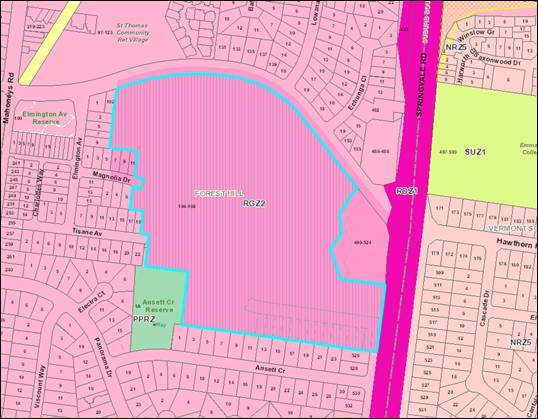
Figure 1 – Zoning
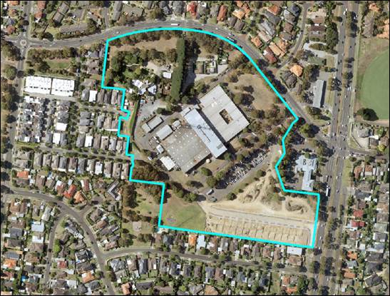
Figure 2 – Aerial Image
Planning Scheme Amendment C157
(Part Two)
Amendment C157 (Part Two) to the
Whitehorse Planning Scheme (Planning Scheme) proposed to include part of the
subject site in the schedule to the Heritage Overlay (HO) as HO272 (refer
Figure 3). At its meeting on 8 August 2016 Council resolved to submit the
amendment to the Minister for Planning for approval. The Minister for Planning
has informed Council of his decision to approve Amendment C157 (Part Two) with
changes, including to reduce the extent of the Heritage Overlay (refer Figure
4) to the three main buildings, the administrative block, studio block and
scenery store as well as the transmission tower. The amendment was
formally gazetted into the Planning Scheme on 1 June 2017.
The proposed site specific heritage
overlay that Council submitted to the Minister for Planning covered a
rectangular shaped portion of the site, including a frontage with Hawthorn
Road. The proposed extent of the HO is shown in Figure 3 below:

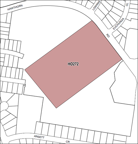
Figure 3 – Proposed Heritage Overlay C157 Part Two
(as exhibited)
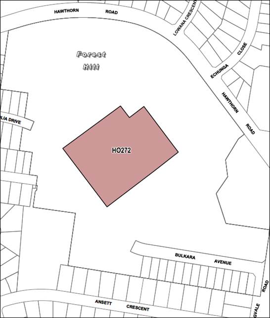
Figure 4 – Approved Heritage Overlay C157 Part Two
Surrounding Development
The subject site is surrounded by
primarily residential properties. The properties adjoining to the west of the
subject site were previously developed by the current owner of the subject
site, Bazem Pty Ltd. These properties were
part of a 48 lot subdivision permit which was lodged with Council in 2004 and
was subsequently approved by VCAT in 2006. The construction of these dwellings
commenced in 2008 and was completed by 2015. The development is primarily two
storey detached buildings, along with a small number of townhouses.
The site has direct access to
Hawthorn Road and adjoins an existing medical centre to the east. The built
form along Hawthorn Road is a traditional residential built form of one to two
storey detached dwellings. Land abutting the southern boundary is used for
housing, with generally a single storey built form.
The site has direct access to
Springvale Road, which is a major arterial road managed by VicRoads.
Strategic Context
Tally Ho Activity Centre
The subject site was previously
recognised as part of the Tally Ho Activity Centre, which is centred 550m south
of the site at the intersection of Springvale Road and Burwood Highway.
However, as part of Amendment C110 to the Planning Scheme the independent panel
recommended that the site should be excluded from the Activity Centre on the
basis of physical separation from the core of the Activity Centre.
Whitehorse Housing Strategy 2014
The site is identified as a
substantial change area in the Whitehorse Housing Strategy 2014 and
within local policy 21.06 of the Planning Scheme. Substantial Change areas
provide for housing growth with increased densities, including inside
designated structure plan boundaries and opportunity areas, in accordance with
the relevant plans as well as around most train stations, adjoining tram routes
and around larger activity centres.
Planning Scheme Amendment C110
Amendment
C110 implemented the Tally Ho Major Activity Centre Urban Design Framework
2007 and the Tally Ho Urban Design and Landscape Guidelines 2013 by
amending the Local Planning Policy Framework at Clauses 21.05, 21.06, 21.07,
22.06 and 22.08 of the Planning Scheme.
The
Amendment applied DPO5 to the site. The Amendment was on public exhibition from
13 March 2014 to 14 April 2014. A Planning Panel hearing was held on 12 and 13
August 2014 to consider all the submissions received in response to the
exhibition.
Council
considered the Planning Panel recommendations at its meeting on 8 December 2014
where it also resolved to adopt the Amendment. The Minister for Planning
subsequently approved the amendment on 30 September 2015 and it came into
effect on 22 October 2015 when the Amendment was published in the Victorian
Government Gazette.
Development Plan Overlay
Schedule 5 (DPO5)
DPO5
requires that a ‘development plan’ is prepared to the satisfaction
of the responsible authority generally before a permit can be granted to use or
subdivide land, remove or create easements, construct a building or construct
or carry out works. A development plan may be prepared and implemented in
stages.
DPO5 specifies conditions and requirements for permits,
and requirements for a development plan including the information that the plan
needs to contain. The Development Plan will be primarily assessed against the
requirements of Schedule 5 to the DPO (Attachment 1) and the decision
guidelines at Clause 65 of the planning scheme.
Planning permits must be generally in accordance with the
approved development plan. The development plan will therefore guide future
planning permit applications for each stage of the development and needs to
contain sufficient information for Council to assess these applications.
Planning permit applications that are generally in
accordance with an approved development plan will be exempt from the usual
notice and review processes under the Planning and Environment Act 1987.
Hence the Development Plan needs to be carefully considered by Council before a
decision is made whether to approve the Development Plan or not.
In order to assist Council in this process, Clause 3 in
DPO5 requires the display of a development plan (or a substantial amendment to
an approved plan) for public comment for a period of at least 14 days. Council
must consider any comments received in response to display of the plan before
making a decision whether to approve the plan. Therefore, in most instances, it
is anticipated that display of the development plan will be the final
opportunity for the community to make comment on the proposed development.
Request to Display Development
Plan
The
proposed Development Plan was lodged on 6 October 2016 by 10 Consulting Group
on behalf of Bazem
Pty Ltd for consideration by Council
(Attachments 2 - 4). Since then officers have had a number of meetings and
discussions with the applicant. This has resulted in updated documents and
further information being resubmitted by 10 Consulting Group.
The Development
Plan is proposed to be undertaken in five stages. The Development Plan before
Council is for the majority of the site, while the central studio portion of
the site will be subject to a separate development plan which is allowable
under the DPO.
The
Development Plan submitted comprises the following documents:
Development Plan Report (10 Consulting Group, May 2017), as shown in
Attachment 2.
The Development Plan Report includes relevant background
to the application with specialist inputs appended, including the following:
· Development Plan and Development Plan Guidelines –
SJB Architects
· Movement Network and Conceptual Functional Layout Plans
– GTA Consultants
· Landscape Concept Plans - SMEC
Supplementary Reports
· Attachment 3 -Forest Ridge -Development Plan Assessment
-Transport Impact Assessment - GTA Consultants
· Attachment 4 – Former ATV 0 Television Studios -
Heritage Advice –Bryce Raworth Pty Ltd.
The Development Plan is
supported by a Design Response (Figure 5 below) that has been prepared by SJB
Architects.

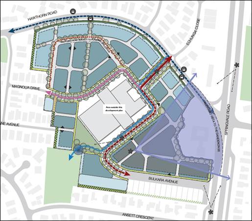
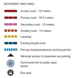
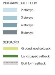
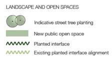
Figure 5 – Development Plan Concept
The Development Plan proposes the following:
· The potential for 600- 700 dwellings;
· A built form of six storeys that transitions to two
storeys at the sites edges where it interfaces with residential properties;
· An internal road system with the main access via a
proposed roundabout on Hawthorn Road, along with a proposed left in left out
access on Springvale Road;
· Public Open Space of 2,275m2 in the south west
corner of the site;
· A central driveway from Hawthorn Road that provides views
into the site from Hawthorn Road;
· Proposed development envelopes to the frontage of the
heritage studios and removal of later 1970’s/80’s addition to the
building;
· A designated shared cycling/pedestrian path and
pedestrian paths through the site;
· The opportunity to provide an active retail frontage to
Springvale Road.
Preliminary review of the
Development Plan is outlined in the Discussion below.
DISCUSSION
The Development
Plan will be assessed by officers against the requirements of the DPO5 and the
relevant requirements of the Planning Scheme following display of the plan for
community comment.
Importantly,
upon preliminary review of the Development Plan, there are some concerns that
officers consider that the proponent ought to address for approval of the
Development Plan:
Heritage
Council officers and
Council’s Heritage Advisor have concerns in regard to how the proposed
Development Plan will impact on the significant heritage place. With the
gazettal of the Minister for Planning’s decision to reduce the extent of
the proposed Heritage Overlay, officers have concerns in regard to the
following:
· The
proposed development of buildings up to four storeys in height in front of the
studios that will constrict the views of the significant heritage place in its
original setting; and
· There
is a lack of detail at this stage as to how the proposed built form will be
sympathetic to the heritage place.
Built Form
There is concern in regard to the
Built Form proposed in the Development Plan. Officers have raised concerns with
the applicant about the proposed six storey built forms and their extent in the
Development Plan. Any development that is proposed to exceed the 13.5m
discretionary height control of the RGZ2 requires significant justification.
Officers consider that this strategic justification has not been addressed in
the Development Plan.
Officers have concerns with the
proposed four storey interface with existing residential properties to the west
and consider that a 2 storey transition should be incorporated into the
Development Plan to provide an appropriate height transition.
Additionally, a six storey built form fronting Springvale Road is of concern.
Officers consider a more appropriate response would be a more generous setback
to Springvale Road with a four storey built form.
Further, it is considered that the
proposed built form setback along Hawthorn Road is inadequate. The Development
Plan proposes a 3.5m setback; Officers consider this to be an unacceptable
response and seek a greater setback.
Landscaping
Officers also consider that the
DPO5 requires more information about existing trees onsite. The
Development Plan should be updated to provide this information and provide
commentary for greater consideration of tree retention measures on site.
Transport
Officers consider that further demonstration and
commentary is required to detail how the proposed pedestrian and cycle links
will integrate with the surrounding network. Further, the Development
Plan should be updated to clearly reflect that there will not be vehicular
access onto Hawthorn Road, other than the one major access point at the
proposed roundabout.
Community Infrastructure
The proposed Development Plan estimates the potential for
1500-1800 new residents. Officers consider that this additional anticipated
population warrants the provision of a community infrastructure assessment to
determine the impacts on surrounding facilities and services, and the need for
any additional community infrastructure.
Future Public Asset
Responsibilities and Agreements
There are various agreements under
section 173 of the Planning and Environment Act 1987 that may be
required. Agreements may be needed in relation to responsibility for future
public assets such as:
· Roads, traffic management and transport infrastructure;
· Public open space and related
infrastructure;
· Stormwater management;
· Street trees;
· Any new community infrastructure that may be needed;
· Staging (e.g.: delivery of key infrastructure and handover
of responsibilities); and
· Maintenance agreements / Asset management.
The applicant has not detailed who
will take on a number of asset management responsibilities. Decisions are yet
to be made on future responsibility for any assets and infrastructure which
requires detail on the development with future planning permit applications.
CONSULTATION
As noted above, the DPO5 requires display of a
Development Plan (or a substantial amendment to an approved plan) for public
comment for a period of 14 days. Council must consider any comments
received in response to display of the plan before making a decision whether to
approve the plan (or amendment to an approved plan).
The following
community engagement program is proposed:
· Consultation period of at least 14 days;
· Notification via the Council web site, mail out to landowners and occupiers in the local
area
and to stakeholders, agencies, local shopping centres and interested persons;
· Whitehorse Leader advertisements in consecutive editions during the consultation period;
· Notices on the site;
· Documents on display at Council’s service centres, libraries in Whitehorse, and on the Whitehorse web site;
· Feedback captured via written submissions.
FINANCIAL
IMPLICATIONS
Community consultation expenses will be recouped from the
applicant. To date, internal officer expertise has been committed from all
divisions across Council to review the Development Plan.
Ongoing internal officer input will be required to
finalise and approve the Development Plan and to assess future planning permits
and building and works approvals. Resourcing required for future planning
permit approvals will be partly offset by notice exemptions in the DPO.
There will be future cost implications to Council if it
assumes ownership and / or responsibility for future maintenance and management
of any public infrastructure on the site. This would include ongoing
operational budget for maintenance and management of matters such as open
space, roads, drains, lighting, potential stormwater treatment, street trees,
and waste collection, as well as capital works into the future to improve and
replace public assets. Further detail on the development during subsequent
planning permit applications is needed to estimate these costs.
The applicant has not detailed who will take on future
ownership and maintenance of assets and officers will be progressing
discussions with the applicant to finalise these arrangements.
Infrastructure needed for the development will be
provided or required as part of the development at the proponent’s cost.
POLICY IMPLICATIONS
The Council Plan 2016 - 2020 and relevant Council
strategies have all informed Council’s approach to the future of this
strategic development site.
The Development Plan is consistent with Strategic
Direction 2 in the Council Plan which seeks to maintain and enhance our
built environment to ensure a liveable and sustainable city. In particular Strategy
2.1.4 is to support and promote greater housing diversity balanced with
preserving the heritage, landscape, cultural and natural environments.
Key relevant
policies in the Planning Scheme include:
· Clause 21.04 Strategic Directions includes the site as a
Strategic Redevelopment Site;
· Clause 21.06 Housing includes the site as substantial
change.
CONCLUSION
A Development Plan has been prepared by 10 Consulting
Group on behalf of the site owner Bazem Pty Ltd, as required under Clause
43.04-1 of the DPO. Clause 3.0 of Schedule 5 to the DPO requires that the
Development Plan be placed on display for public comment for a period of 14
days.
Council officers have undertaken a preliminary review of
the proposed Development Plan in line with the DPO5 and the Planning Scheme.
Council officers have some initial concerns, as outlined in this report, about
some elements of the Development Plan, however, it is considered that the
Development Plan can advance to display for public comment.
Concurrent with display of the Development Plan and
consideration of any community feedback received, Council officers will
continue to review the Development Plan and pursue any necessary changes to the
document to address concerns, and progress, as appropriate, discussions with 10
Consulting Group Pty Ltd in relation to future agreements on the provision of
and responsibility for public infrastructure.
It is therefore recommended that Council resolve to place
the Development Plan for the site on display for the requisite comment period
and pursue the necessary changes as outlined in this report.
Attachment
1 Development
Plan Overlay Schedule 5 ⇨ 
2 Forest Ridge
Development Plan May 2017 ⇨
3 GTA Traffic
Impact Assessment ⇨
4 Heritage Advice
- Bryce Raworth ⇨
Ordinary Council Meeting 26
June 2017
9.1.3 Review
of Heritage Assistance Fund
SUMMARY
A review of the Whitehorse
Heritage Assistance Fund has been undertaken as a result of a Council
resolution on 13 February 2017. This report discusses the background to the
Heritage Assistance Fund and the review which has been undertaken.
As a result of the review
amendments are proposed to the funding criteria which have been considered by
the Whitehorse Heritage Steering Committee.
|
RECOMMENDATION
That Council:
1. Notes the report.
2. Authorises
Officers to update the Heritage Assistance Fund eligibility criteria in line
with the recommendation from the resolution dated 13 February 2017 and this
report.
|
background
The Whitehorse Heritage Assistance
Fund (HAF) commenced in 2005. The fund was created following an investigation
into heritage incentives, to relieve the actual or perceived burden of owning a
property within the Heritage Overlay in Whitehorse. The fund was created
to encourage the preservation of properties by providing financial assistance
towards maintenance costs associated with a owning a significant heritage
property.
Since the fund began in 2005,
Whitehorse City Council has undertaken an additional five heritage studies.
These studies were implemented through five separate planning scheme amendments
to the Whitehorse Planning Scheme (Planning Scheme) and are summarised below:
· Amendment
C74 - City of Whitehorse Individual Properties Review 2006: Gem of Box Hill,
Courthouse Estate & Mates Housing Estate, and Windsor Park Estate &
Elmore Houses, Blackburn (HLCD Pty Ltd). Resulted in 32 individual and 1
precinct (8 properties) being included in the Heritage Overlay;
· Amendment
C129 - William Street Precinct Report 2010 (HLCD Pty Ltd). Resulted in 1
precinct (9 properties) being included in the Heritage Overlay;
· Amendment
C140 - City of Whitehorse Heritage Assessments 2010 (HLCD Pty Ltd). Resulted in
28 individual places and 1 precinct (5 properties) being included in the
Heritage Overlay;
· Amendment
C157 - Whitehorse Heritage Review 2012 (Coleman Architects Pty Ltd). Resulted
in 29 individual places and 3 precincts (271 properties) being included in the
Heritage Overlay. Part Two of the amendment seeking to apply a Heritage Overlay
to one (1) individual place has been approved by the Minister for Planning with
changes. However, Part Two of the amendment has not been formally gazetted into
the Whitehorse Planning Scheme as of this report.
· Amendment
C172 – City of Whitehorse Post-1945 Heritage Study 2014 (Built Heritage
Pty ltd). Resulted in 16 Individual places and 2 precincts (14 Properties)
being included in the Heritage Overlay.
These five planning scheme
amendments have resulted in an additional 412 properties being included on the
Heritage Overlay, which has brought the total number of properties covered by
the Heritage Overlay in the Planning Scheme to 1325 places.
Since 2005, the HAF has had ongoing financial commitment from
Council. The HAF has had two funding increases from the original $10,000 in
2005/2006. The first funding increase was in 2006/2007 which saw a $5,000
increase to $15,000 in total. The second increase was $10,000 in 2012/2013
which increased the total funding to $25,000.
While the funding has increased, property owners or grant
applicants are expected to contribute financially to the cost of the project
for which they are applying. Accordingly, each application can seek funding of
up to 80 per cent of the total cost of the project, with the maximum grant per
application being $1000. A summary of the HAF since 2005/2006, which details
the successful applications and the financial level of assistance from Council
is provided below:
|
Financial Year
|
Total
Applications
|
Successful
applications
|
Council
Allocated Funds
|
|
2005/2006
|
14
|
12
|
$10,000
|
|
2006/2007
|
19
|
17
|
$15,000
|
|
2007/2008
|
18
|
15
|
$15,000
|
|
2008/2009
|
41
|
25
|
$15,000
|
|
2009/2010
|
22
|
18
|
$15,000
|
|
2010/2011
|
40
|
17
|
$15,000
|
|
2011/2012
|
37
|
16
|
$15,000
|
|
2012/2013
|
42
|
30
|
$25,000
|
|
2013/2014
|
37
|
26
|
$25,000
|
|
2014/2015
|
39
|
28
|
$25,000
|
|
2015/2016
|
33
|
24
|
$25,000
|
|
2016/2017
|
48
|
22
|
$25,000
|
|
Total
|
390
|
250
|
$225,000
|
Over twelve years, the HAF has
provided $225,000 in funding to support 250 applications from individuals,
community groups and organisations in their endeavours to maintain properties
of heritage significance in the municipality.
Since its inception the awareness
and popularity of the HAF has grown significantly. In the 2016/2017 financial
year, Council received its most applications for the HAF with 48 being lodged.
Of the successful 22 applications, the total value of the works quoted was
$201,283.
At the Special Committee meeting on
Monday 13 February 2017, Council resolved the following motion to review the
Heritage Assistance Fund:
Item 7.1 – Review of Heritage Assistance Fund
1. Refer to the 2017/18 budget process an increase in the
Heritage Assistance Fund to $40,000 per annum.
2. Increases the maximum assistance available to $2,000
per heritage application.
3. Increases the maximum contribution up to 100% of the
proposed project subject to Council’s
discretion.
4. Refers the funding conditions to the Heritage
Committee for review and receive a report back from the Heritage Committee by
June 2017.
Officers referred the motion to the
Whitehorse Heritage Steering Committee for discussion.
DISCUSSION
The Whitehorse Heritage Steering Committee met on the 18th
April 2017 to discuss the motion that was resolved at the Special Committee
meeting on Monday 13 February 2017.
The committee discussed the
potential implications of the proposed motion and agreed that it would not have
a significant impact on the HAF assessment process. The Whitehorse Heritage
Steering Committee supports the motion to increase the maximum assistance from
$1,000 to $2,000 and to increase funding up to 100% of each application,
subject to Council’s discretion. The committee considered that
these changes would further encourage and assist property owners with the
maintenance and enhancement of their heritage properties.
The committee also noted that the
motion would only require minor alterations to Council’s current HAF
assessment criteria and application process. The HAF applications are
internally assessed against standard eligibility criteria and include criteria
such as heritage significance of building/property, demonstrated need for the
project, location, method and appropriateness of works along with procedural
requirements such as providing cost estimates for the proposed works.
If an application meets the
required eligibility criteria it is then progressed to a further detailed
assessment. All applications are assessed individually and given a score
against the assessment criteria. These applications are then compiled and a
funding recommendation is presented to the Whitehorse Heritage Steering
Committee. The committee reviews all applications and provides a funding
recommendation to the General Manager City Development for approval.
CONSULTATION
As noted above the motion was
referred to the Whitehorse Heritage Steering Committee, who supported the
motion in full. The Draft budget is currently on public exhibition with a
report due back to Council on Tuesday 13 June 2017. Therefore the community has
the ability to be engaged on the funding increase through the annual budget
process. As of this report, it is not known if there were any submissions about
the increase in HAF funding.
FINANCIAL
IMPLICATIONS
It is
considered that no additional staffing resources will be required to administer
the proposed changes to the HAF. However, Council will incur future costs
associated with increasing the HAF from $25,000 to $40,000 per annum. If
the 2017-18 budget is approved these costs will be covered by the budget.
POLICY IMPLICATIONS
The proposed increase of funding,
maximum assistance and maximum contribution subject to Council’s
discretion for the HAF supports Strategic Direction 2 of the Council Plan
2016-2020 which is to maintain and enhance our built environment to ensure a
liveable and sustainable city by ensuring that significant buildings are
preserved.
CONCLUSION
The motion raised at the Special
Committee meeting on Monday 13 February 2017 is supported by Council Officers
and the Whitehorse Heritage Steering Committee. The items in the motion will
provide further incentive for owners of properties in the Heritage Overlay to
maintain and enhance these significant buildings. Increasing the funding of HAF
will potentially allow for Council to support more property owners and fully
fund vital maintenance works.
It is recommended that Council note
the report and that officers update the HAF eligibility criteria for 2017/2018
in line with the recommendation from Council’s resolution dated 13
February 2017.
Ordinary Council Meeting 26
June 2017
Engineering and Environmental
9.1.4 Tender
Evaluation (Contract 20041) 836-850 Whitehorse Road, Box Hill
SUMMARY
To consider tenders received for
the streetscape renewal works adjacent to 836-850 Whitehorse Road, Box Hill and
to recommend acceptance of the tender received from The Trustee for The GP
Bluestone Unit Trust, trading as GP Bluestone, for the amount of $663,479.62,
including GST.
|
RECOMMENDATION
That Council accept the
tender and sign the formal contract document for Contract 20041 –
836-850 Whitehorse Road, Box Hill received from The Trustee for The GP
Bluestone Unit Trust (ABN 21 664 700 435), of 8A Epson Street, Laverton,
Victoria 3028, trading as GP Bluestone, for the tendered amount of $663,479.62,
including GST.
|
BACKGROUND
In recent years, Council has
completed streetscape renewal works within the State Government designated
Metropolitan Activity Centre (MAC) of Box Hill. These works have focused on key
locations within the MAC to ensure Box Hill users are provided with accessible,
functional, comfortable and sustainable public spaces. The proposed streetscape
renewal works adjacent to the development site at 836 - 850 Whitehorse Road,
Box Hill will support an expected increase in pedestrian traffic once the
development is completed.
The proposed streetscape renewal
works use the Box Hill Structure Plan (2007) and Box Hill CAA Urban Landscape
Design Guidelines (2011) as the base for their design. These strategies define
a standard of quality, style and consistency in public realm treatments within
the MAC.
The renewal works, as per previous
streetscape renewals in the MAC, incorporate bluestone paving, granite feature
paving and street furniture. Further to this, street tree planting, some
exposed aggregate paving and streamlined planter boxes have been incorporated
into the streetscape design. Five street trees are to be removed as part of
these works and are to be replaced with five new street trees that are better
suited to the urban environment and site context. An existing Yarra Valley
Water water main located along the Whitehorse Road frontage of the development
site requires relocation as requested by Yarra Valley Water, to provide for the
construction of the planter boxes as part of the streetscape works.
The works provide a mutual benefit
for Council and the development site, in that a high quality and consistent
streetscape treatment will be constructed in this part of the MAC as an overall
precinct development. The treatment includes a significant contribution by the
development group that will satisfy several Planning Conditions relating to the
streetscape. The works are proposed to be completed in stages to accommodate
for building occupancy.
DISCUSSION
Tenders were advertised in The Age
newspaper on Saturday 8 April 2017 and were closed on Wednesday 3 May 2017. A
total of seven (7) tenders were received.
The tenders were evaluated against
the following criteria:
• The
Tender Offer;
• Tenderers
experience in provision of similar services;
• Quality
of Tenderers Work;
• Proposed
construction methodology;
• Availability
of tenderer to complete the works; and
• Occupational
Health & Safety and Equal Opportunity (Pass/Fail).
The tender submissions were
evaluated using a weighted averages method, equal opportunity and OHS were
assessed on a Pass/Fail basis. The results of the assessment are summarised in
the attached Tender Evaluation Form.
The Trustee for The GP Bluestone
Unit Trust is the recommended tenderer for this Contract and has been ranked
the highest in the Evaluation Matrix. It has proven, extensive experience
including the use of significant quantities of bluestone paving on past
projects, and demonstrated it can complete the works to a high standard and
within the specified timeframe. References in relation to previous projects it
has worked on were excellent, with high quality projects being delivered for
Citywide, the City of Melbourne and the City of Whitehorse in the past.
The recommended Tenderer has
included a suitably qualified Contractor as part of their Tender to complete
the relocation of approximately 30 metres of a Yarra Valley Water water main,
as requested by Yarra Valley Water. The developer has agreed to pay the total
costs for the water main relocation as part of their streetscape upgrade
contribution to Council.
The development group are providing
a significant contribution towards the completion of the streetscape works
which essentially allows for the upgrade of this portion of streetscape sooner
than Council would otherwise undertake. This contribution will go towards a
superior palette of materials and reinforce Council’s commitment and
priority in providing streetscape treatments within the MAC that are consistent
with strategies and principles supporting Box Hill as a Metropolitan Activity
Centre.
The tender received from The
Trustee for The GP Bluestone Unit Trust is considered to be the best value for
money for this Contract.
CONSULTATION
This project has been developed in
consultation with representatives from the development group of 836-850
Whitehorse Road, Box Hill. Internal stakeholders from the Planning and Building
Department, CityWorks and ParksWide Departments have also been consulted
throughout the design and its development.
External stakeholders including
VicRoads and Yarra Valley Water have also been consulted.
Premises in near proximity to the
works will be advised in writing of the proposed works and expected impacts of
construction before works commence.
FINANCIAL IMPLICATIONS
A standard business viability assessment
of the preferred tenderer has been considered.
This project will
be part funded by the adjacent development by way of a contribution towards the
streetscape upgrade works.
|
|
Budget
|
Expenditure
|
|
Developer
Contribution as per Condition 38 of Permit WH/2014/763 (Amended) in relation
to the requirements of the 173 Agreement
|
$ 490,385
|
|
|
2014-49
Box Hill CAA (2017/18 Draft Budget)
|
$ 250,000
|
|
|
Total
Budget
|
$ 740,385
|
|
|
Preferred
tenderer’s lump sum offer (including GST)
|
|
$ 663,480
|
|
Less GST
|
|
- $ 60,316
|
|
Net cost
to Council
|
|
$ 603,164
|
|
Developer
Contribution to Contingencies
|
|
$ 36,000
|
|
Plus
Council Contribution to Contingencies
|
|
$ 24,316
|
|
|
|
|
|
Plus
Project Management Fee (Council Cost)
|
|
$ 60,316
|
|
Tree
removal and planting
|
|
$ 10,000
|
|
Sub
Total
|
|
$ 694,630
|
|
Plus Expenditure to date (T813)
|
|
$
13,217
|
|
Total
Expenditure
|
|
$ 720,579
|
Ordinary Council Meeting 26
June 2017
9.1.5 Laneway
302 (Between 134 and 136 Canterbury Road, Blackburn South) – Road
Required for Public Use and to be Open to Public Traffic
FILE NUMBER: 52/07/302
SUMMARY
The purpose of this report is for Council to give notice
of its intention to declare, by resolution, that the laneway known by Council
as Laneway 302 (located between 134 and 136 Canterbury Road, Blackburn South)
is a road that is reasonably required for public use and is to be open to
public traffic.
|
RECOMMENDATION
That Council, in accordance with section 204(2) of
the Local Government Act 1989 (LGA), and every other power given to Council
enabling it to:
1. In accordance with sections 207A(c) and 223
of the LGA, directs that public notice be given in the Whitehorse Leader
newspaper and published on Council’s Internet website of ‘the
intention of Council to declare, by resolution, at its ordinary meeting to be
held on 26 June 2017 that the road known by Council as Laneway 302 is
reasonably required for public use and is to be open to public traffic’
(road). (The road is located between 134 and 136 Canterbury Road, Blackburn
South and is shown set aside or appropriated as a road on plan of subdivision
LP31183 lodged at the Land Titles Office on 9 August 1955).
2. Directs that separate letters enclosing a
copy of the public notice be sent to the persons who are the owners and
occupiers of the properties in and around the area which generally surround
the road, including the owners and occupiers of the properties adjoining the
road (and including the owner and occupier of 136 Canterbury Road, Blackburn
South who has entered into occupation of a part of the road), advising of
Council’s intention to declare, by resolution, that the road is
reasonably required for public use and is to be open to public traffic.
3. In accordance with section 223(1)(b)(i) of
the LGA directs that a Committee of Council is to hear any persons who in
their written submissions under section 223 of the LGA have requested that
they be heard in support of their submissions and appoints and authorises
Councillors Munroe and Massoud (or their appointed nominees, so long as they
are serving Councillors) to be members of the Committee that is established
by Council to hear any persons who in their written submissions under section
223 of the LGA have requested that they be heard in support of their
submissions.
4. Authorises
the Manager of Engineering and Environmental Services or the person for the
time being acting in that position to carry out any and all other
administrative procedures necessary to enable Council to carry out its
functions under sections 207A(c) and 223 of the LGA.
|
background
This report relates to the
unconstructed laneway that is referred to and known by Council as Laneway 302
(the laneway or the road). The relevant section of
laneway is located between 134 Canterbury Road and 136 Canterbury Road,
Blackburn South and is shown set aside or appropriated as a road on plan of
subdivision LP31183 lodged at the Land Titles Office on 9 August 1955.
The property owner and occupier of
136 Canterbury Road have without permission from Council constructed a fence
that encloses a section of the laneway. The fence is for the full width of the
laneway which is 3 metres and approximately 18 metres long from the rear
boundary of 136 Canterbury Road. The fence is a paling timber fence with steel
access gates at each end. The fence blocks through access through and along the
laneway.
The section of laneway that is
enclosed is shown in red on the image below.
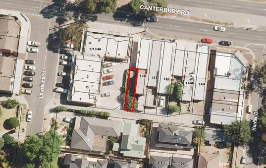
Currently vehicles and pedestrians
wanting to have access between 134 and 136 Canterbury Road are traversing
across the car park at the rear of 134 Canterbury Road, which is private
property. The occupation of the laneway also restricts the car parking that can
be provided at the rear of 134 Canterbury Road. The fact that the laneway is
blocked means that vehicles that turn into the laneway may have to reverse out
into Canterbury Road if they cannot access through the private car park at the
rear of 134 Canterbury Road.
DISCUSSION
The status of the laneway is that
it is classified by Council as an ‘unconstructed’ road. It has not
been constructed to Council’s standards and therefore it is not
registered as a public road on Council’s register of public roads under
the Road Management Act 2004, although it nonetheless may be (and is presently
considered by Council to be) a public highway within the meaning of the Local
Government Act 1989 (LGA) and the common law (primarily based on
past usage by the public). In these circumstances, and whether or not the road
is a public highway, Council assumes no responsibility for the inspection,
repair or maintenance of such roads because Council’s current policy is
that it does not ordinarily maintain unconstructed roads throughout the
municipality.
However, and whether or not the
laneway is already a public highway, it is still considered that the laneway is
a ‘road’. This is because it is and remains shown as set aside or
appropriated as a road on plan of subdivision LP31183 lodged at the Land Titles
Office on 9 August 1955. As such, the laneway is considered to be and remain
under the discretionary care, management and control of Council. It is
Council’s present position that all of the properties which adjoin the
road, and members of the public generally, have a lawful right to use the whole
of the road. On this basis, it is considered that the road cannot, without the
permission and authority of Council, be lawfully obstructed so as to limit,
restrict or prevent any rights of access, vehicular or pedestrian, over and along
the road.
Section 204(2) of the LGA provides
that, “A Council may, by resolution, declare a road that is reasonably
required for public use to be open to public traffic.”
It follows that, if Council is
ultimately able to form the view that the road is “reasonably required
for public use” and should be “open to public traffic”, then
Council has the power to make a declaration to this effect.
Assuming the road is not already a
public highway, the making of such a declaration by Council does not, of itself,
make the road a public highway. This means that, in the future and if through
changed circumstances, Council were to form the view that the road is no longer
“reasonably required for public use” and should no longer be
“open to public traffic”, then Council would have the power to pass
another resolution so as to give effect to this view, without the need to
commence a separate statutory process to formally discontinue the road.
CONSULTATION
On 24 October 2016 (and following
the request of some property owners of 134 Canterbury Road), Council sent a
consultation letter and survey to 43 property owners and occupiers in and
around the local area asking whether or not they supported a proposal to open
the section of the laneway that is occupied.
A total of 21 responses were
received (49% response rate), with 67% supporting the proposal, and 33%
opposing the proposal.
If Council adopts the
recommendations in this report, the 43 property owners and occupiers in and
around the local area will be sent a notice from Council advising of
Council’s intention to declare, by resolution, that the laneway is
reasonably required for public use and is to be open to public traffic.
A public notice would also be
published in the Whitehorse Leader newspaper and on Council’s Internet
website. Persons may make a written submission to Council (under sections
207A(c) and 223 of the LGA) and they have a right to be heard in support of
their submission by a Committee of Council appointed for that purpose. It is
recommended that the Ward Councillors, Cr Munroe and Cr Massoud, be appointed
as the members of the Committee to hear any submissions.
Council would then need to formally
consider any submissions which are received and any report of the Committee
hearing submitters before a final decision is made by Council at a subsequent
meeting of Council.
FINANCIAL IMPLICATIONS
If approval is given to open the
laneway to public traffic, Council will take steps to require the property
owner of 136 Canterbury Road to remove the fencing and gates from around the
enclosed and occupied land and obstructions from the land, failing which
Council will take such steps itself at the cost of the property owner of 136
Canterbury Road utilising other powers available to Council under the LGA.
Council would need to fund from its
Operational Budget the administrative and legal costs associated with the
declaration and the opening of the laneway, estimated to be approximately
$12,000. Council is advised that the property owner of 136 Canterbury Road may
seek to claim the occupied section of road by adverse possession and this could
lead to a legal dispute between Council and the property owner.
Ordinary Council Meeting 26
June 2017
9.1.6 Review
of Council’s Road Management Plan
SUMMARY
The purpose of this report (review report) is to
summarise and present to Council the results of the review of Council’s
Road Management Plan as required by section 54(5) of the Road Management Act
2004 and Division 1, Part 3, of the Road Management (General) Regulations 2016.
It is recommended that the findings and conclusions of the review, as set out
in this report, be adopted by Council and that a subsequent amendment of the
Road Management Plan proceeds in accordance with the results of the review.
This report, following adoption by Council, constitutes the review report required
by regulation 9(2) of the Road Management (General) Regulations 2016..
|
RECOMMENDATION
That Council:
1. In accordance
with the requirements of section 54(5) of the Road Management Act 2004 and
Division 1, Part 3, of the Road Management (General) Regulations 2016 in
relation to the review of Council’s Road Management Plan, Council
hereby adopts the findings and conclusions of the review of Council’s
Road Management Plan, as set out in this report.
2. That, as a result of
the review, Council proceeds to commence the separate and
further statutory process to amend its Road Management Plan in accordance
with the findings and conclusions of the review, including any
other amendments (subject to Council’s further consideration) that may
result from the further public consultation process to be undertaken by
Council, or from any other comments and recommendations made by Council
departments or other relevant stakeholders.
3. The
findings and conclusions of the review, as set out in this report, be made
available for copying or inspection at the place where the Council’s
Road Management Plan may be inspected or obtained in accordance with section
55(1)(b) of the Road Management Act and on the Internet site maintained by
Council.
|
background
The Chief Executive Officer, acting
under delegated authority pursuant to section 98(1) of the Local Government Act
1989, and in accordance with the requirements of section 54(5) of the Road
Management Act 2004 and Division 1, Part 3, of the Road Management (General) Regulations
2016 (and in particular regulations 8 and 9) (the Regulations) in
relation to the review of Council’s Road Management Plan directed that
the process to conduct a review of Council’s Road Management Plan be
commenced (the review) on 15 March 2017, and completed by 30 June
2017.
It is no longer a statutory
requirement for Council to give public notice of the proposed review or to
invite submissions from the public in relation to the review.
Council adopted its first Road
Management Plan in October 2004, and also approved the Public Roads Register
(which lists all the roads throughout the municipal district which Council
considers are “reasonably required for general public use”, and
which are subject to the requirements specified in the Road Management Plan),
in accordance with the requirements of Division 5 of the Road Management Act
2004.
Council adopted its current Road
Management Plan on 17 August 2015 after reviewing the 2009 version of the Road
Management Plan.
The Roads Register has, since its
first adoption by Council, had six revisions that have been adopted by the
Manager Engineering and Environmental Services under delegation, dated 20
January 2005, 3 February 2006, 14 October 2006, 17 November 2006, 19 February
2010 and 16 October 2013 respectively.
The Road Management Plan provides
Council with a legal “Policy Defence” in civil liability against
claims of negligence or breach of statutory duty arising from the standard and
condition of the roads and road related infrastructure that are under
Council’s administration. In short, the Road Management Plan details how,
and by what standards and priorities, Council will inspect, repair and maintain
its public roads in the context of available budgetary and other resources.
Council’s insurers undertake
an annual risk assessment and audit of Council operations in relation to Public
and Professional Liability and the results influence Council’s insurance
premiums. Council’s Road Management Plan and compliance with the Plan is
included in these assessments by Council’s insurers.
The purpose of the review is to
ensure that the standards in relation to, and the priorities to be given to,
the inspection, maintenance and repair of the roads and road related
infrastructure to which the Plan applies are appropriate.
Appropriate Council departments and
other stakeholders have been consulted and the review has now been completed.
Following the review, this report is presented to Council for noting and
adoption. The report outlines the results of the review and provides
recommendations to Council on amendments to the Road Management Plan.
This report otherwise constitutes
– and is presented to Council as – the written report summarising
the findings and conclusions of the review now undertaken in accordance with
the requirements of the Regulations (review report).
Following the review and
Council’s adoption of the review report, Council, subsequently and under
a separate statutory process, will be requested to proceed to amend its Road
Management Plan.
DISCUSSION
Process and procedure
In accordance with the Road
Management Act and the Regulations, there are a number of matters Council must
do, and then subsequently may do, following the review of the Road Management
Plan.
· First,
Council must produce a written report (being this Council report and being the
report which also constitutes the review report) summarising the findings and
conclusions of the review, and make the review report available for copying or
inspection at the place where the Road Management Plan may be inspected or obtained in accordance
with section 55(1)(b) of the Road Management Act and on the Internet site
maintained by Council.
· Secondly,
Council may then decide to amend the Road Management Plan. Amendments that are
recommended to Council may come from this review, the public consultation
process required to be undertaken by Council when amending the Plan, or from
comments and recommendations made by Council departments or other stakeholders,
or a combination of all of these. The amendment of the Road Management Plan is
a separate statutory process from the review which is the subject of this
review report. The proposed detailed amendments of the Road Management Plan
will be presented to Council in a further report and this will require the
giving public notice and a consideration of any submissions (because the review
report recommends to Council that Council amend its Road management Plan in a
manner that requires the giving of public notice under regulation 10).
Report summarising findings and conclusions of review
The results of the review of the Road
Management Plan and the recommended changes are summarised as follows:
· Update
references to Council’s current Asset Management Policy and Strategy.
· Update
references to the current Council Plan.
· Update
information relating to setting levels of service and how this relates to
previous Best Value Service Reviews.
· Update
information relating to the performance management and internal auditing process
including reviewing the audit timeframes.
· Update
the section on ‘Standards for Construction, Expansion, Upgrade, Renewal
and Refurbishment’ to include references to all relevant standards
including Council standards, Austroads guidelines, Australian Standards and
VicRoads standards.
· Update
information relating to Occupational Health and Safety.
· Reference
Council’s Risk Management Strategy and include relevant claim forms.
· Update
information relating to Council’s budget for road funding.
· Revise
the standards of maintenance for various Council infrastructure assets such as
roads and footpaths, including inspection frequencies, in order to ensure that
the standards (while still considered to be reasonable) are in fact attainable,
having regard to the resources which Council has allocated (and will continue
to allocate) to the fulfilment of Council’s road management functions.
This report and review meets the
compliance requirements of the Road Management Act and the Road Management
(General) Regulations 2016 for Council to review Council’s Road
Management Plan by 30 June 2017.
Subject to acceptance of this
review report by Council, a further report will be presented to Council
recommending the detailed changes to the Road Management Plan which are
required to give effect to the findings and conclusion of the review. This will
then require the commencement of a separate statutory process, including the
giving of public notice and a consideration by Council of any public
submissions received.
It is recommended that Council
notes and adopts the findings and conclusions of the review of the Road
Management Plan as set out above and that it adopts this report as the review
report for the purposes of regulation 9(2) of the Regulations.
CONSULTATION
Relevant Council Departments were
consulted as part of the review.
FINANCIAL IMPLICATIONS
The type of road assets and the
inspection, maintenance and repair standards included in the Road Management
Plan directly relate to Council budget allocations as well as acceptable,
appropriate and reasonable standards of safety, asset management, levels of
service and risk minimisation strategies. Budgetary and resource implications
were also taken into account as a part of the review, insofar as they determine
the standards of inspection, maintenance and repair which are being recommended
to Council.
POLICY IMPLICATIONS
The review has
concluded that amendments, both in relation to substantive changes and also to
change administrative procedures and responsibilities and to make changes that
are fundamentally declaratory or of a machinery nature, are required to the
Road Management Plan.
Ordinary Council Meeting 26
June 2017
9.2 Human
Services
9.2.1 Renaming
Harding Street Reserve, Surrey Hills to Bluebell Hill Reserve.
SUMMARY
Council received a request from
the Harding Street Reserve Advisory Committee for the reserve located at 16-18
Harding Street, Surrey Hills to be formally named ‘Bluebell Hill’
Reserve. Council Officers have completed a consultation process which referred
to the statutory requirements for naming features recommended by the Office of
Geographic Names. This report provides details on the consultation and
information on the proposal for Council’s final consideration and approval.
|
RECOMMENDATION
That Council:
1. Approve
the name change from Harding Street Reserve to Bluebell Hill Reserve.
2. Refer the name change to the Registrar, Office of Geographic Names
for endorsement.
|
BACKGROUND
The reserve
located at 16-18 Harding Street, Surrey Hills (the reserve) is classified as a
local open space area which is bordered by Harding Street, Erasmus Street, and
a number of residential properties. The reserve is 0.788 ha in size and
is the home of the Bluebell Hill Tennis Club which consists of two community
tennis courts and a clubhouse. The reserve also includes a lookout, informal
seating, a playground, linking paths and a number of established garden beds
including mature trees. Local residents would typically use the reserve
to play tennis, visit the playground, informal games of cricket or football and
passive recreation.
The Harding Street
Reserve Advisory Committee have requested that the reserve be formally named
‘Bluebell Hill’ reserve to reflect the site’s historical
links to farmland in the 1860s.
DISCUSSION
Council received a request from the
Harding Street Reserve Advisory Committee for the open space area currently
known as Harding Street Reserve in Surrey Hills to be formally named
‘Bluebell Hill’ reserve. The request included the signatures of 43
residents surrounding the reserve, who are in support of the proposal.
Although there is
no specific or stand-alone policy for the naming of an open space area where a
place name is requested rather than a request to name an open space area to
commemorate a person, the naming or renaming of any Council facility, including
parks and reserves is subject to Council’s Criteria and Procedures for
Naming Council Facilities after Individuals Policy (naming policy).
Other relevant procedural requirements within the naming
policy include consideration of guidelines within the Geographic Place Names
Act 1998. The proposal to name the reserve ‘Bluebell
Hill’ reserve conforms to the requirements of the Act and Council’s
naming policy.
A 30 day consultation process with the community has been
undertaken seeking support or objections to the proposal.
· Overall
20 submissions were received, 19 in support and 1 submission suggesting an
alternate name. No objections to the name were received.
The renaming reflects historical
links to the reserve. Originally in the 1850’s the parkland was a quarry.
As the area developed local
identity John Barratt established a farm in the 1860s on top of the nearby hill
in Harding Street. A copy of the auction notice confirmed the name
‘Bluebell Hill’ when John Barratt placed the farm on the market in
1868.
Council officers believe the name
will also provide consistency alongside the existing tennis facility established
in the reserve that has previously changed its name to be known as the Bluebell
Hill Tennis Club.
CONSULTATION
The proposal was
advertised for a 30 day consultation process (conforming to the Office of
Geographic Names guidelines) allowing the community an opportunity to comment.
This process included:
· Email to Harding Street Reserve Advisory Committee advising them of
the process.
· The Whitehorse community was informed via advertisement in the
Whitehorse Leader and Whitehorse News (Distribution the week of March 27th
2017).
· Council’s website.
· Mail out to local residents (238 letters in total).
Overall 20 submissions were received, 19 in support and 1
submission suggesting an alternate name. No objections to the name were
received.
FINANCIAL IMPLICATIONS
If the proposed name is approved, the naming policy calls
for Council to arrange for the installation of identification signage for the
reserve. The reserve would require an identification sign at the Harding
Street entrance which would include a double panel sign that also identifies
the Bluebell Hill Tennis Club, consistent with Council’s signage
guidelines. The financial cost is estimated at $4,500 and will be covered in
existing budgets.
Ordinary Council Meeting 26
June 2017
9.3 Corporate
Reports
9.3.1 Adoption
of the Proposed Budget 2017/18 and Draft Strategic Resource Plan 2017-2021
ATTACHMENT
SUMMARY
This report recommends that
Council adopt the Proposed Budget 2017/18, which incorporates the Strategic
Resource Plan, in accordance with Sections 126, 127 and 130 of the Local
Government Act 1989.
|
RECOMMENDATION
That Council:
A Having:
1. Considered all written submissions;
2. Heard the presentations of submissions;
3. Received the report of the Special
Committee (minutes extract Attachment 1) of its meeting held on 13 June 2017;
and
4. Considered officer comments (as
attached Attachment 2),
now adopt the Proposed
Budget 2017/18 inclusive of the Strategic Resource Plan 2017-2021 (Attachment
3) in accordance with Section 130 of the Local Government Act 1989.
B Thank persons making submissions in
writing for their contribution and advise them of the outcome of
Council’s decision.
C Authorise
the Chief Executive Officer to give public notice of Council’s decision
in accordance with Section 130(2) of the Local Government Act 1989 and submit
a copy of the budget to the Minister in accordance with Section 130(4) of the
Local Government Act 1989.
|
background
The Proposed Budget 2017/18 was presented to the Special Council meeting on 24
April 2017 and public notice advertised, in accordance with Section 129(1) and
(3) of the Local Government Act 1989, in The Age newspaper on Saturday
29 April 2017.
The Proposed Budget 2017/18 was available for public inspection for 28 days after
publication of the notice, in accordance with the Local Government Act 1989
and the Local Government (Planning & Reporting) Regulations 2014.
Submissions regarding the Proposed
Budget 2017/18 were required to be received by Sunday
28 May 2017 for consideration by Council at its Special Committee meeting, held
on Tuesday 13 June 2017. The details of submissions received are contained in Attachment
1 of this report.
DISCUSSION
The Proposed Budget 2017/18 is in line with Council’s long-term financial
plan, and ensures that Council continues to meet the community’s demand
for high quality services and facilities while maintaining its financial
sustainability into the future.
The Proposed Budget 2017/18 has
been prepared with emphasis for the coming year on a continuation of service
delivery for our community, providing consistency and support for our
residents. The budget funds a range of community services including health and
family services, home and community care, the maintenance of community
facilities, parks, gardens, playgrounds, infrastructure, waste and recycling
collection, and building and planning services. In addition, the Capital Works
Program provides for a sustainable level of funding for the renewal of the
community’s infrastructure and an investment in major community
facilities such as the development of the Nunawading Community Hub and
redevelopment of the Whitehorse Centre.
The key features of the Proposed
Budget 2017/18 are:
An operational
budget that enables the delivery of services to the community including:
· $14.51 million Sustainability, Waste and Recycling
· $14.33 million Home and Community Care
· $12.34 million Leisure Facilities
· $11.26 million Health and Family Services
· $10.47 million ParksWide (maintenance of sports fields, parks and
gardens)
· $7.83 million City Works (depot operations, maintenance of
footpaths, drains and roads)
· $6.95 million Recycling and Waste Centre
· $6.89 million Planning and Building Services
· $5.61 million Arts and Cultural Services
· $5.27 million Compliance (Community Laws, parking, school crossings,
risk, insurance and emergency management)
· $5.09 million Libraries
· $4.69 million Engineering
· $3.68 million Major Projects and Buildings
· $2.08 million Community Development
· $1.02 million Parks Planning and Recreation
· $0.94 million Investment and Economic Development
· $0.66 million Assets and Capital Works
A $43 million
Capital Works Program comprising:
· $19.52 million for land, building and building improvements
· $5.77 million for roads, bridges and off street car parks
· $5.27 million for plant and equipment
· $3.48 million for parks, open space and streetscapes
· $3.19 million for drainage improvements and waste management
· $3.03 million for footpaths and cycleways
· $2.87 million for recreational, leisure and community facilities
KEY PRESSURES AND CHALLENGES
In preparing
this Budget, Council considered a number of external and internal influences.
These include:
· The
average rate will rise by 2.0% in 2017/18 in line with the order by the
Minister for Local Government in December 2016 under the Fair Go Rates
System
· Changing
community needs and expectations as a result of an ageing and increasingly
culturally diverse population
· The
cost of maintaining Council’s infrastructure assets. This is to ensure
that infrastructure assets are provided to support services that are
appropriate, accessible, responsive and sustainable to the community
· Cost
shifting by other levels of government. Cost shifting occurs where local
government provides a service to the community on behalf of the State or
Federal Governments. Over time, the funds received by Council do not increase
in line with real cost increases
· A
further 2.0% increase in the State Government landfill levy to an anticipated
cost of $63.27 per tonne, representing a 603% increase over the past nine years
· Increasing
community expectations for Council to be a leader in environmental
sustainability
· Continuing
low interest rates restricting Council’s ability to generate earnings on
cash and investments; and
· Enterprise
Agreement wage increase of 2.0% or $26 per week, whichever is greater effective
from September 2017.
CONSULTATION
The Proposed
Budget has been carefully prepared following consultation with the community
throughout the year. Council values the feedback it receives from community
members to understand what services and facilities are important to the
community and to determine the focus of future priorities. Consultations that
have informed the development of this Budget include a significant Your Say
Whitehorse community engagement program to develop our Proposed Council
Plan 2017-2021, the 2016 Community Satisfaction Survey, consideration of
prior year public budget submissions, and consultation on various Council
strategies and plans.
Council invited the community to provide feedback to better
understand their needs and expectations of Council through the Your Say
Whitehorse campaign, which was held in late 2016 during the early stages of
development of the Proposed Council Plan 2017-2021 and Municipal
Health and Wellbeing Plan 2017-2021. In total, 1,260 people participated in
this campaign which included an extensive survey, community workshop, online discussion
forum and five pop-up events at various locations across the municipality.
Public
submissions
Council received seven formal
submissions/comments on the Proposed Budget 2017/18.
Four people spoke in support of their submission at the Special Committee
meeting.
Submissions were received from the following:
The full
text of the submissions are attached, included in Attachment 1.
The following people spoke to their submissions:
|
|
Name
|
|
1
|
Mr K.
Weeks
|
|
2
|
Mr C.
Carter
|
|
3
|
Mrs S.
Hayes, representative of
Utassy
Ballet School Parents Association
|
|
4
|
Mrs S.
Hayes
Director
and Principal
Utassy
Ballet School
|
CHANGES TO THE PROPOSED bUDGET 2017/18
Subsequent to approving the Proposed Budget
2017/18 on Monday 24 April 2017, Council has received notification of expected
funding levels which vary from earlier budget estimates. The Proposed Budget
2017/18 has been updated to reflect the following changes:
· Council
has been notified that $2.20 million (approximately half) of the estimated
2017/18 Financial Assistance Grant from the Victoria Grants Commission will be
brought forward and paid to Council in June 2017,
· Council
has been advised of the expected school crossing subsidy amount for 2017/18,
which is $35,000 lower than previously budgeted, and
· Three
new fees for the Watts Street Car Park have also been added to the fees and
charges schedule in Appendix A of the Proposed Budget 2017/18 after Council
resolution at the Ordinary Council Meeting held 15 May 2017 (Agenda Item 13.2).
Attachment
1 Extract Special
Committee Minutes 13 June 2017 Inclusive of Submissions ⇨ 
2 Submissions
Table 2017-18 ⇨
3 Proposed Budget
2017-18 ⇨
Ordinary Council Meeting 26
June 2017
9.3.2 Adoption
of the Proposed Council Plan 2017-2021
ATTACHMENT
SUMMARY
This report
recommends that Council adopt the Proposed Council Plan 2017-2021, which
incorporates the Strategic Resource Plan as required under the Local Government
Act 1989.
|
RECOMMENDATION
That Council:
1. Adopt the proposed Council Plan 2017-2021 as
the overarching strategic document which sets out the goals, related approach
and measures of success for the next four year period, and which contributes
to the achievement of the Council Vision 2013-2023;
2. Acknowledge that the Strategic Resource Plan
contained in the Council Plan 2017-2021 does not commit Council’s
resources until the consideration of the Annual Budget each year;
3. Authorise the Chief Executive Officer to give public notice and submit a
copy of the Council Plan 2017-2021 to the Minister of Local Government in
accordance with Section 125 (5) of the Local Government Act 1989.
|
background
As required by the Local Government
Act 1989, Section 125, Council is required to prepare a council plan. The council
plan must include strategic objectives, strategies for achieving these
objectives and strategic indicators for monitoring achievement of the strategic
objectives.
The Council Plan was developed
through an extensive community engagement campaign, Your Say Whitehorse,
which provided Councillors, community and staff with an opportunity to inform
and guide the new Council Plan.
Through this community engagement,
Council has developed a series of goals (strategic objectives) which form the
overarching guidance for Council in this Council Plan. These goals are
underpinned by the Strategic Directions contained within our community’s
long-term vision, ‘Council Vision 2013-2023’, which are a
broad set of statements that articulate the aspirations of our community for
the municipality’s future.
Under each goal within the Council
Plan, Council has listed the approach (strategies) to achieving that goal,
including measures of success (strategic indicators).
Council has also featured the
relevant strategies, plans and policies that are externally focused and which
support the relevant goal/s. Furthermore, Council has also included the
services it delivers. Service delivery is a key driver for the
achievement of each goal.
DISCUSSION
The proposed
Council Plan 2017-2021 will guide Council over the next four years to ensure
the city continues to be a healthy, prosperous and sustainable community
supported by strong leadership and community partnerships.
The proposed
Council Plan 2017-2021 is underpinned by the five Strategic Directions
contained within our community’s long-term vision, ‘Council
Vision 2013-2023’. These are as follows;
1. Strategic
Direction 1 – Support a healthy, vibrant, inclusive and diverse community
2. Strategic
Direction 2 – Maintain and enhance our built environment to ensure a
liveable and sustainable city
3. Strategic
Direction 3 – Protect and enhance our open spaces and natural
environments
4. Strategic
Direction 4 – Strategic leadership and open and accessible government;
and
5. Strategic
Direction 5 – Support a healthy local economy.
The proposed
Council Plan has seven goals (strategic objectives) which form the overarching
guidance for Council. This in turn is then supported by 33 related
approaches (strategies) to be implemented over the next four years to help
achieve these goals, including 74 measures of success (strategic indicators).
The proposed
Council Plan also incorporates a Strategic Resource Plan which identifies the
resources required over the next four years to deliver on the Council
Plan. The Strategic Resource Plan includes a financial allocation based
on Council’s Long Term Financial Plan, Human Resource Strategy, Rating
Information, Borrowing Strategy, and Asset Management Strategy. The Plan
also contains a set of financial statements as required by legislation.
CONSULTATION
Whitehorse City
Council embarked on one of its most comprehensive community engagement
programs, Your Say Whitehorse. The Your Say Whitehorse
campaign provided a range of avenues for engagement with the community during
November and December 2016. Your Say Whitehorse was designed to
help build and inform two key strategic and legislated documents, the Council
Plan 2017-2021 and the Municipal Public Health and Wellbeing Plan 2017-2021.
During the five
week Your Say Whitehorse community engagement process, Councillors,
residents, visitors, community groups, employees, stakeholders and local
businesses were invited to share their thoughts through various community
engagement activities ranging from completing a survey (in person, in writing
or online), to attending a community workshop, visiting a pop-up event or going
online to the Your Say Whitehorse discussion forum/website.
The many
opportunities to be involved were widely promoted, with the Your Say
Whitehorse program reaching approximately 165,000 people through
distribution of the Whitehorse Leader and Whitehorse News, and more than 10,200
people directly targeted through distribution of postcards and surveys.
The program was also promoted through community networks. The program
reached a wide group of people, including Whitehorse’s harder to reach
groups. In addition, Councillors actively participated in the program at
the pop up events, soliciting feedback individually, through engaging with
their networks to complete surveys, as well as facilitating sessions to gain
community feedback.
The Whitehorse
City Council Community Engagement Findings report describes the engagement
program and the key findings from participant feedback and is available online
on Council’s website. In total, 1260 people participated in this
consultation campaign.
Advertisements providing formal
public notification of the adoption of the proposed Council Plan 2017-2021 for
consultation were placed in The Age on Saturday 29 April 2017 and the
Whitehorse Leader on Monday 1 May 2017.
Council received no responses in
relation to the proposed Council Plan 2017-2021.
FINANCIAL IMPLICATIONS
The proposed Council Plan 2017-2021
identifies proposed broad strategies that will guide Council’s actions
over the next four years and in so doing inform the development of the next
four Council budgets. It aims to ensure that Council remains financially
sustainable over the next four years and for the longer term.
POLICY IMPLICATIONS
Council Plan 2017-2021
Attachment
1 Proposed
Council Plan 2017-2021 ⇨ 
Ordinary Council Meeting 26
June 2017
9.3.3 Review
of Council’s Procurement Policy
FILE NUMBER: sf08/2
ATTACHMENT
SUMMARY
This report presents a reviewed
Procurement Policy (June 2017) for consideration and adoption by Council.
|
RECOMMENDATION
That Council adopts the Procurement Policy dated
June 2017, as presented in Attachment 1.
|
BACKGROUND
Section 186A of the Local Government Act 1989 requires
Council to prepare, approve and comply with a procurement policy that
encompasses the principles, processes and procedures that are applied to the
purchase of goods, services and works.
The legislation requires the policy
to be reviewed once in each financial year.
Council adopted the current
Procurement Policy on 27 June 2016. A review of the Policy has been
undertaken and a revised policy is attached (see Attachment 1).
DISCUSSION
It is recognised that effective
procurement management is essential to ensure that Council achieves compliance,
transparency, open and fair competition, value for money and good governance.
The Procurement Policy (the Policy)
encompasses these goals and provides a robust foundation for the conduct of
procurement activities by Council.
Minor improvements have been made
to the Policy to ensure that it continues to reflect best practice in the Local
Government industry.
CONSULTATION
Council engaged consultant Russell
Kennedy Lawyers in May 2015 to conduct review of the Procurement Policy. Their
report confirmed that the policy reflects best practice in local government
procurement. All policy additions and amendments recommended were made by
Council to further strengthen purchasing activities and system
processes.
Following recent consultation with
various Managers, Coordinators and procurement officers, minor amendments have
been made to this Policy.
Upon adoption, the revised Policy
will be posted on Council’s website and will be made available to the
public in hard copy format at the Whitehorse Civic Centre.
FINANCIAL
IMPLICATIONS
A key objective
of the Policy is to deliver value for money for Council (and therefore
ratepayers) in the form of social, economic and environmental benefits.
POLICY
IMPLICATIONS
The Procurement
Policy dated June 2017 will replace the current Procurement Policy dated June 2016
in Council’s Corporate Policy Manual.
Attachment
1 Draft
Procurement Policy ⇨ 
Ordinary Council Meeting 26
June 2017
9.3.4 Tender
Evaluation (Contract 20039) Provision of Debt Recovery Services
ATTACHMENT
SUMMARY
To consider Tenders received for the Provision of Debt
Recovery Services and to recommend the acceptance of the Tender received from
Recoveries & Reconstruction (Aust) Pty Ltd, for the amount of $992,500
including GST and to consider the overall project expenditure.
|
RECOMMENDATION
That Council accept
the tender and sign the formal contract document for Contract number 20039
for the Provision of Debt Recovery Services received from Recoveries
& Reconstruction (Aust) Pty Ltd (ABN 96 072 086 125), of Suite 2, 93
Watton Street, Werribee, for the tendered amount of $198,500 per annum
including GST; as part of the total expected project expenditure of $992,500,
including GST for a five year period.
|
BACKGROUND
The successful Tenderer is required to collect overdue
monies due to Council for statutory outstanding rates and charges levied in
accordance with Part 8 of the Local Government Act 1989 (the LGA) and
for “Fees for Service” (additional garbage services) debts.
The proposed contract is a single five years term, with no
further options.
Provisions
under section 180 of the LGA allow all Victorian Councils to recover unpaid
rates and charges via the Magistrates’ Court. Before proceeding to
the Magistrates’ Court, several steps are taken in an attempt to recover
the unpaid rates and charges, these being:
· An
Overdue Notice,
· A
Letter of Demand if the debt remains unpaid after the Overdue Notice.
Council’s
practice has been that ratepayers receiving a pension rebate and any ratepayer
with a debt below the average residential rate for the relevant financial year,
receive a Letter of Demand but they are not pursued via the Magistrates’
Court process. The reason for this that the costs associated with the
Magistrates’ Court process are costly and these costs are added to the
unpaid rate and charge debt.
Additionally,
Council when collecting unpaid rates and charges apply the principles contained
within the Victorian Model Litigant Guidelines.
Debt recovery
on Fees for Service debts is not completed in accordance with the LGA; this is
because these debts are not a charge on the property and are consequently a
debtor.
The current contract, Contract 11056, expires 15 July 2017
and all options to extend the current Contract have expired.
DISCUSSION
The tender was advertised on
Saturday 1 April 2017 in The Age newspaper and on Council’s website, and
closed on Thursday 27 April 2017. Five tenders were received.
The tenders were
evaluated against the following criteria:
· Financial Benefit to Council;
· Online Provision of System Functionality;
· Experience in Large and Small Debt Recovery;
· Methodology in the Debt Collection Process; and
· Occupational Health & Safety, Equal Opportunity and Business
Viability.
Recoveries &
Reconstruction’s (R&R) experience in debt recovery and their
methodology regarding the debt collection process was considered to be very
good by the Evaluation Panel.
The points of
difference with R&R, was the financial benefit to Council and their
comprehensive online system.
R&R’s
price was the lowest of the five tenderer’s and all costs can be passed
onto the ratepayer, which means no cost to Council. Additionally, R&R
included collecting the Fee for Service debt at no cost to Council.
R&R’s
online system provided high quality functionality, which will deliver
efficiencies for Council and better customer service to ratepayers and debtors.
Their awareness
and knowledge of legislative requirements was strong and Local Government is
their sole focus, meaning their business revolves around servicing the needs of
Local Government clients only.
R&R has other
councils as clients for debt recovery in both rates and charges and sundry
debtors. Industry performance indicators show a successful collection
rate on unpaid accounts.
The tender
received from R&R is considered to be the best value for money for this
Contract by the Evaluation Panel.
CONSULTATION
Anne Dalton from Anne
Dalton & Associates, a member of the Whole of Government Probity Panel
(Victoria) was appointed as Probity
Advisor.
Site visits were conducted at the offices of the two
shortlisted tenderer’s specifically for the purpose of viewing their
online systems and functionality.
Referees from four other Councils were consulted and each
provided satisfactory references of R&R.
R&R’s business viability has been professionally
examined and rated as very strong.
FINANCIAL
IMPLICATIONS
The tender price used in the evaluation
was based on the standard debt recovery process for unpaid rates, commencing
with issuing debt collection letters through to issuing Summons for Oral
Examination.
Also considered in the evaluation
was the entire debt collection process for Fees for Service.
POLICY IMPLICATIONS
The Rates Hardship Assistance
Policy will be used in conjunction with any hardship claims received from a
ratepayer. Any ratepayer who is eligible for hardship will be treated in
accordance with the policy.
Attachment
1 Probity Report
Anne Dalton & Associates - Provision of Debt Recovery Services ⇨
Ordinary Council Meeting 26
June 2017
9.3.5 Tender
Evaluation (Contract 20035) Provision of Parking Services
FILE NUMBER: 17/80246
SUMMARY
To consider tenders received for the Provision of Parking
Services and to recommend the acceptance of the
tender received from Tenix Solutions.
|
RECOMMENDATION
That Council accept the tender and sign the
formal contract document for Contract 20035 for
the Provision of Parking Services received
from Tenix Solutions (ABN 73 075 154 755), of Level 5, 277 William Street,
Melbourne 3000, for the tendered amount of $550,750.20, including GST.
|
BACKGROUND
Council at its meeting of 12
December 2016 considered a report on the Provision of Parking Services and
resolved to:
“1. Endorse
the report;
2. Approve a tender document be prepared for the
provision of field staff to deliver an extended parking service trial;
3. Approve that the trial be conducted for two
years with a one year option to extend subject to a final assessment and report
to Council on the outcome
4. Approve the employment of an additional Compliance Support Officer
for the term of the trial”
As a result, tenders were invited
to assist Council manage an extended parking enforcement program by providing
additional resources to address peak and extended hours parking demands.
DISCUSSION
The services tendered by Council
are an important part of the broader parking management program with the aim to
improve equitable access to limited parking spaces, promotion of turnover of
trade opportunities after hours responsiveness and provision of special needs
parking such as disabled parking and loading, bus and taxi zones over an
extended period.
The tender was advertised in The
Age newspaper and Council’s website on Saturday 11 March 2017 and was
closed on 29 March 2017. Three (3) tenders
were received.
The tenders were evaluated against
the following criteria:
· The
Tender Offer;
· Experience
in the provision of a similar service;
· Capacity
to provide the service;
· Ability
to provide the service within the timeframe.
Of the three tendered offers, one
provider demonstrated a clear capacity and capability to deliver the tendered
service through existing similar contracts with local government
authorities.
Tenix Solutions have been providing
Parking Enforcement solutions, specifically the management of on street
operations for in excess of 14 years and are currently providing parking
enforcement in the municipalities of Monash, Glen Eira, Hume and Stonnington.
Tenix staff are trained and have
extensive experience in management of the Road Rules, client expectations and
achievement of deliverables. The unsuccessful tenders were unable to
demonstrate experience or staff expertise in the delivery of the tendered
service.
The compliant tender response
submitted by Tenix Solutions clearly outlines how they intend to deliver the
services required, a robust reporting framework and addresses all the
prerequisite criteria of the tender. The tender submitted demonstrates:
· A
proven track record of the provision of similar services;
· High
level of accuracy and reliability backed up by reference checks; and
· Capacity
to deliver services required and achieve projected outcomes.
CONSULTATION
FINANCIAL IMPLICATIONS
|
|
Budget
|
Expenditure
|
|
Preferred
tenderer’s lump sum offer (including GST)
|
|
$550,750.20
|
|
Less GST
|
|
-$50,064
|
|
Net cost to Council
|
|
$500,642
|
|
Total Expenditure
|
|
$500,642.20
|
Additional ongoing costs associated with this project
include employment of a Compliance Support Officer for back office support and
the acquisition of equipment to enable the service to be delivered.
Based on performance standards of the tender it is
anticipated that the initiative will be cost positive.
Ordinary Council Meeting 26
June 2017
9.3.6 Tender
Evaluation (Contract 20042) Provision of Animal Pound Services
FILE NUMBER: sf17/200
SUMMARY
To consider tenders received for the provision of animal
pound services and to recommend the acceptance of the tender received from
Victorian Animal Aid Trust, trading as Animal Aid, on a Schedule of Rates basis
for a period of 3 years commencing on August 1, 2017 and to consider the
estimated expenditure over the life of the contract.
|
RECOMMENDATION
That Council:
1. Accept
the tender and sign the formal contract document for Contract 20042 for the
provision of animal pound services received from Victorian Animal Aid Trust
(ABN 80 004 260 244), of 35 Killara
Road Coldstream Victoria 3770 trading as Animal
Aid, on a Schedule of Rates basis for a period of 3 years
commencing on August 1, 2017
2. Authorise
the Chief Executive Officer to award an extension of this contract, subject
to a review of the Contractor’s performance and Council’s
business needs, at the conclusion of the initial 3 year contract term.
|
BACKGROUND
Through a contractor, Council
operates a pound facility for housing stray and seized animals which Council
and the community bring to the pound facility. Impounded animals are
provided with accommodation and care in accordance with relevant legislation,
including the provision of veterinary services as required.
The contract with the RSPCA expired
in November 2016 with services currently being provided by agreement.
DISCUSSION
Tenders were advertised in The Age
newspaper on Saturday April 8, 2017 and were closed on May 8. Tenders from the
RSPCA and the Victorian Animal Aid Trust (VAAT) were received.
The tenders were evaluated against the following criteria:
· The
Tender Offer;
· The
Tenderer’s experience in the provision of similar services;
· Tenderer’s
capacity to provide the services; and
· Occupational
Health & Safety and Equal Opportunity
Councils have a statutory
responsibility to accept animals impounded by staff or surrendered by the
public. As part of the previous contract with the RSPCA, Council agreed to also
pay for public impounds
In 2016 951 animals were impounded
at the RSPCA with 562 handed in by the public and 133 animals were surrendered
by their owners. Of the 500 requests to Council to collect stray and
wandering animals, 50% were returned to their owners avoiding the necessity of
being impounded with 256 animals being impounded.
Both tenders submitted demonstrated:
· Extensive
experience in the provision of animal pound services with existing contracts
with multiple local governments:
· Accessible
support services such as veterinary and rehousing capabilities,
· Staff
expertise in the provision of similar services,
· Accessibility
by the public seven days a week;
· Facilities
capable of servicing the contract; and
· Experience
in the care and management of domestic animals.
While the capabilities and capacity
to deliver the tendered service were similar, the cost of the provision of the
service was substantially different.
The RSPCA advised in December 2016
of an increase in their fee structure over the previous contract levels of 300%
due to increased operational costs and funding shortfalls. The tender
submitted by the RSPCA confirmed this advice with substantial fee increases
across all levels of the tendered service provision.
While the RSPCA tender brings
advantages of a location in Burwood and experience in provision of the service
to the Whitehorse community, the tender received from Animal Aid is considered
to provide the best value for money for this Contract.
FINANCIAL IMPLICATIONS
The contract for the provision of
animal pound services is based on a Schedule of Rates. The rates are subject to
a CPI adjustment on each anniversary of the contract.
Using impound data for the 2016
calendar year including the fate of the animal, the fee structure submitted by
both tenderers was applied to each nominated category. The financial analysis
of the two tender offers resulted in a projected annual cost for the VAAT being
significantly lower than that of RSPCA for the provision of the animal pound
service.
The tender calculation is based on
all 951 animals being impounded including the 562 public impounds. However,
based on the fact that Council reunite approximately 50% of animals it collects
rather than impounding them, the tendered amount of VAAT potentially will be
further reduced as council staff will have an opportunity to treat those
animals prior to them going into the pound.
Savings presented by VAAT tender
however will be partially offset by the cost of servicing the contract.
As the VAAT are based in Coldstream
staff time and the cost of impounding animals will increase. It is
anticipated staff time to impound animals will increase from approximately 10%
of one EFT to 40% of one EFT.
Other additional expenditure will be
incurred including $12,000 per year in motor vehicle operating costs and a once
off payment of $5,000 to retrofit vehicles with rear air conditioning units to
enable the keeping of animals prior to transportation to the pound.
The estimated expenditure under this
contract over the initial contract term is $516,945 including GST. This
expenditure will increase to approximately $861,575 including GST (plus an
additional annual 2% CPI increase) if the option to extend the contract are
exercised.
The costs incurred under this
contract will be charged to the relevant recurrent budgets.
Ordinary Council Meeting 26
June 2017
9.3.7 Investigation
into the Transparency of Local Government Decision Making
SUMMARY
Ombudsman released her report,
‘Investigation into the Transparency of Local Government
Decision-Making’, on the 15 December 2016. The Ombudsman reports
that almost 25% of complaints received by her Office relate to local
government, and this investigation was launched in response to continued complaints
regarding a lack of transparency in operations and decision-making.
The Ombudsman’s investigation was
wide-reaching, and its findings will have implications for all councils across
Victoria. The investigation found that although most councils in Victoria are
not engaging in widespread, deliberate, secretive behaviour, some councils are
not upholding public interest by failing to give sufficient attention to
transparency, or to balance it appropriately with the need for efficiency.
|
RECOMMENDATION
That Council commends the work of the Ombudsman
and concurs and supports the practical suggestions and recommendations
leading to greater transparency in the local government sector and the
ongoing commitment of Whitehorse Council to continue to promote the principles
of transparency and accountability.
|
background
Council at its meeting held on 30 January 2017 resolved:
That Council receive a report from officers which
responds to the Victorian Ombudsman’s report titled ‘Investigation
into the Transparency of Local Government Decision Making’ dated December
2016.
The investigation by the Victorian Ombudsman has revealed
that of the 3,400 complaints about local government in 2015-16, a portion
related to complaints about decisions being made in secret or behind closed
doors.
The investigation was conducted in two stages. Stage 1
consisted of an overview of the state’s 79 councils, and meetings with 26
past and current Councillors, Mayors, council staff and local government peak
bodies. Stage 2 involved the examination of 12 focus councils.
The investigation looked into how councils conduct their
decision-making, including in open council meetings, closed council meetings,
outside meetings and under delegated authority (that is, decisions made by the
Chief Executive Officer and Council officers on behalf of the Council).
The Ombudsman found that with so many different council
decision-making structures and processes in place, transparency of local
government decisions can be random in nature, and at times, ad hoc.
However, conversely, the Ombudsman also found that some
councils are proactive in being transparent by using social media to engage
with their communities and promote meetings, and using live streaming to
facilitate public engagement with council meetings.
Some other key findings of the Ombudsman’s
investigation include:
• The
way the public wants to engage with councils and receive information about
decisions is changing with an expectation that information will be quickly and
easily accessible via council websites.
• The
notice of motion process can be a transparent way for councillors to raise
issues at council meetings. However, where notices of motion are raised without
adequate time to be thoroughly researched, they can affect both the quality of
decision making and transparency. There are examples of notices of motion
being used inappropriately to decide matters affecting both council policy and
budget.
• Debate
is a crucial aspect of council meetings that assists the public to understand
the reasons for council decisions and demonstrates that each decision has been
critically considered by councillors. However, there is evidence that in some
cases, discussion in briefing sessions, where councillors feel they can be more
open, comes at the expense of debate in the chamber.
The Ombudsman’s report drives
home the importance of councils being open and accessible to the public, with
exceptions to this rule being applied with great care.
DISCUSSION
Critical points for Council to note
from the report include the following:
“Accessibility is no
longer simply about ensuring physical access to the council chamber. As the
public become increasingly used to engaging with organisations and receiving
information through digital media, it is essential that councils keep pace with
these expectations, while ensuring that more traditional methods, such as
visiting council offices, are still available.”
“Open council meetings give the public an
opportunity to see their elected representatives at work. Providing easy access
to council meetings encourages attendance and interest in council activity,
which in turn improves the transparency and accountability of decision
making.”
“Live streaming / broadcasting of meetings and
public participation in open meetings were identified as factors which
“have an impact on the accessibility and transparency of decision
making”
“Even when decisions are made in an open and
minuted council meetings the full story of how and why a decision is made is
not always told”
“Many of the unseen influences on council decisions
are linked to councillor conduct…These influences may present risks to
the transparency of council decision making and include; undeclared personal
interests; intimidating councillor behaviour; undeclared external influences;
factions/bloc voting; and councillors influencing officer reports”
“There are a range of unseen factors which can
impact on council decision making…tacit agreements or arrangements
reached outside council meetings, including during briefing sessions for
councillors”
The Ombudsman concludes that: “when councils make
decisions on behalf of their communities and the information related to those
decisions is not made accessible to the public, this reduces community
confidence that council is acting in the public interest. The exceptions to
openness should be limited and applied with great care.”
Council’s decision-making practices are in line with
this fundamental principle and there is a high level of administrative scrutiny
applied to utilising the relevant section of the Local Government Act 1989 (the
Act) to nominate a matter as ’confidential’. The majority of
these confidential matters apply to contractual matters. A minimum of
Council reports are discussed in closed Council in accordance with the Local
Government Act 1989 (the Act), such as a decision about a commercial in-confidence
matter or other similar issue, the vast majority of these decisions are still
made available to the public in the Council meeting minutes.
The website ‘Know your Council’ performance
measures indicates that Whitehorse’s result in regard to the percentage
of meetings closed to the public is 8.65% compared to similar councils at 9.45%
and around the state average of (11.57%). The low number of meetings held in
confidence is an indication of a high level of transparency at Council.
Decisions made by Council at meetings closed to the public are in accordance
with the requirements of Section 89 of the Act and include contractual and
personnel matters, proposed developments and legal advice. During
2015-16, Council considered some matters which by nature were ongoing over a
number of meeting cycles. Examples include sale of Council owned land,
consideration of potential land acquisition of additional open space, which are
appropriate and in accordance with the requirements of the Act due to the sensitive,
legal and liability issues affecting the parties involved.
Residents have access to a number of avenues to understand
how the decision has been made, through attending Council and Committee
meetings, Council minutes, media releases, Whitehorse leader column and
advertorials, specific services Facebook pages, community meetings, Public
submissions, Council question time and website, ongoing community engagement,
events and activities and other tools. Residents may not always agree
with Council decisions, but the transparency allows them to understand the
reasoning and discussion behind the decision.
The Ombudsman’s report highlights that demonstrating
an active and ongoing commitment to transparency is critical to good governance
in all aspects of council business.
Being proactive in communicating Council decisions and
engaging with our community are top priorities of Council. This is
evident in the diverse array of mediums we have in place to keep residents
informed of issues affecting their everyday lives.
Transparency and accountability
in decision-making is critical to good governance, and strengthening
transparent decision-making will assist
The Recommendations in the
report (p. 148), cover a broad range of matters, most of which are recommendations
pertaining to a higher level of prescription by the State Government regarding
council meetings and governance for incorporation into legislation or
regulation.
The Ombudsman made six recommendations to the Victorian
Government and Local Government Victoria regarding policy and legislative
changes to enhance transparency in the local government sector.
The six recommendations in the report generally cover:
• Prospective
suggestions for the review of the Local Government Act,
• Suggested
guidance for a number of matters pertaining to council meeting processes,
• Suggested
amendment to the FOI Act, in regard to closed meetings of Council
• Suggesting
a uniform Councillor Code of Conduct and training,
• Suggesting
governance and meeting procedure review.
Councillors will note that the
State Government response from DELWP (the relevant government department) on
page 178 of the report where the Department states disagreement with a number
of the matters recommended by the Ombudsman. This suggests that these may
not subsequently be incorporated into any legislative or regulatory framework
as prescribed. Most notable of the Department’s comments pertain to
the conflict between many of the recommendations and the intention of the Local
Government Act review currently underway which seeks to “acknowledge
the unique status of local government as a constitutionally recognised tier of
government………………….for this reason a
key objective of the review is to enhance the autonomy of councils. However,
this is balanced against the State’s interest in ensuring the sector is
functional and appropriately governed”. The tenor of the
Department’s response is not to move to the prescriptive frameworks
suggested by the Ombudsman’s report, but rather to provide best practice
approaches that do not detract from council’s independence.
With respect to a couple of the
more practical suggestions in the Ombudsman’s report from a Whitehorse
perspective the following is being considered and or actioned:
Audio Recording of Meetings
Officers have explored the
inclusion of audio recordings on Council’s website. The outgoing
cost of this is approximately $15,000 (ex GST) plus officer time. This
cost is already included in Council’s draft budget for 2017/2018, with some
further investigation occurring with regard to the legal implications of
publishing content and the associated risk management issues, given that
council meetings do not carry an equivalent to parliamentary privilege.
It is noted the Department of
Environment, Land, Water and Planning (DELWP) is concerned that audio recording
of closed meetings potentially increases the risk of confidential information
being inappropriately disclosed. Nor is it certain that audio recording
councillors during closed meetings is the most effective means of improving
councillor behaviour. The Department does not support the
Ombudsman’s recommendation on this matter.
Distribution of Council Agenda
The question of timing of
distribution of council agendas is also canvassed by the Ombudsman with a
recommendation of 5 days availability to the community. We have extended
the distribution of the public agendas and minutes to make them available on
the Council website on Wednesdays being 5 days prior to meetings.
Confidentiality sunset
provision
A requirement for councils to
include a ‘sunset’ provision in relation to all items discussed in
closed meetings, which specifies a date or event after which the information
will no longer be confidential without a further resolution of council.
Officers in preparing a report and recommendation can suggest a
‘sunset’ date as applicable to the contents of the report and/or
decision and if agreed, confidentiality would no longer apply from that
date. In the event a date is not applicable, a particular event could be
specified as when confidentiality no longer applies. Due diligence and
care should be applied to ensure matters involving privacy and reputation, or
privileged legal advice is not breached. It is noted the Department of
Environment, Land, Water and Planning does not support a fixed sun-setting
provision.
Review of Meeting Guides
Review of meeting guides to
limit the ability of tacit agreements or arrangements being reached outside
Council meetings, including during briefing sessions for Councillors.
Whitehorse Councillor Briefing sessions and adopted charters provide for the
following:
• Reports
are not presented for Councillor Pre-determination of issues being put to a
subsequent Council/Committee forum; for debate on the ultimate officer recommendation
being put to Council; or to invite Councillor Pre-approval of any subsequent
recommendation by officers. These informal and confidential briefing sessions
provide the opportunity for Councillors to be informed, to discuss, challenge,
question and clarify matters of Council business and meeting agendas.
They are also for Councillors to discuss policy formulation and
direction. They are not a forum for debate.
It is a matter for the Chair
(Mayor) to chair the meeting to ensure that proper conduct and process is
applied to ensure compliance and transparency and this is managed well at
Whitehorse.
Current Statutory Transparency
requirements include:
· Agendas for and minutes of (public) Ordinary and Special Meetings of
Council
· Audit Committee Provisions
· Conflict of Interest Provisions
· Corporate Policies available on Council’s website
· Councillor Code of Conduct
· Councillor Entitlements and Reimbursement of Expenses
· Equal Opportunity Officer and Plan
· Equal Opportunity and Protected Disclosure incident reporting - Annual
Report
· Human Rights Provisions
· List of Donations and Grants
· Local Government Performance Reporting Framework
· Minutes of (public) Special Committee Meetings
· Procurement Policy
· Protected Disclosure Procedures
· Public Notice Submission process for Key Strategies, Budget, Council
Plan, Proposed Sale of Council Property
· Register of Authorised Officers appointed under section 224(1A) of the
Act
· Register of Delegations under sections 87(1) and 98(4) of the Act
· Register of Interstate and Overseas Travel by Councillors and Officers
· Register of all Land Leases where Council is the lessor
· Register of Interest returns by Councillors, Senior and Nominated
Officers and Independent Audit Advisory Committee members
· Staff Code of Conduct provisions
CONCLUSION
Council commends the work of
the Ombudsman and concurs with the practical transparency suggestions and
recommendations and that they be further considered as a contribution towards
the review of the Local Government Act.
CONSULTATION
Not applicable
Ordinary Council Meeting 26
June 2017
9.3.8 Municipal
Association Act Review
ATTACHMENT
SUMMARY
This report seeks Council’s
approval to endorse the MAV submission on behalf of the sector in regard to the
review of the Municipal Association Act 1907.
|
RECOMMENDATION
That Council:
1. Note the consultation paper issued by the
Department of Environment, Land, Water and Planning (DELWP) in May 2017
(as attached)
2. Endorse the MAV submission (as attached)
3. Advise
DELWP that Council supports the MAV Submission (as amended) and the
creation of contemporary legislation that delivers a governance and
accountability framework for the MAV to perform its functions and represent,
promote and support the interests of Victorian Councils.
|
DISCUSSION
The Municipal Association Act 1907 (‘the Act’)
is currently under review.
The review seeks to develop contemporary legislation for the
Municipal Association of Victoria (MAV), to enable it to perform its functions
and represent, promote and support the interests of Victorian councils.
The review also seeks to address the recommendations set out
in the Victorian Auditor-General's review of the effectiveness of support for
Local Government.
This is the first comprehensive review of the Act since its
enactment in 1907 and presents an unparalleled opportunity to ensure
contemporary standards of governance and accountability are embedded in the
Act, and that the range of services and support provided to councils and
councillors is properly reflected.
A consultation paper setting out the proposed reforms to the
Act has been circulated to all councils by DELWP. A copy of this document is
attached.
The key objectives of the proposed reforms are to:
· Provide
a clear understanding of the MAV's roles and responsibilities;
· Embed
contemporary processes to ensure integrity and good conduct;
· Provide
a framework of strategic planning and performance monitoring against desired
outcomes;
· Create
an obligation to report and be accountable to member councils;
· Provide
for a comprehensive insurance regulatory framework.
A copy of the MAV submission is
also attached which is sound and reasonable in its approach and it is
recommended Council support it and advise the MAV and DELWP accordingly.
CONSULTATION
Councillors discussed and reviewed
the MAV Submission at a briefing session
FINANCIAL IMPLICATIONS
Not applicable.
POLICY IMPLICATIONS
Not applicable.
Attachment
1 MAV Review
Consultation Paper ⇨
2 MAV Draft
Submission to the MAV Review Consultation Paper ⇨
Ordinary Council Meeting 26
June 2017
9.3.9 Delegated
Decisions April 2017
SUMMARY
The following activity was undertaken by officers under
delegated authority during April 2017.
|
RECOMMENDATION
That the report of decisions made by officers under
Instruments of Delegation for the month of April 2017 be noted.
|
|
DELEGATION
|
FUNCTION
|
Number for April
2016
|
Number for April 2017
|
|
Planning and Environment Act
1987
|
Delegated Decisions
|
111
|
101
|
|
Strategic Planning Decisions
|
2
|
Nil
|
|
Telecommunications Act 1997
|
|
Nil
|
Nil
|
|
Subdivision Act 1988
|
|
24
|
15
|
|
Gaming Control Act 1991
|
|
Nil
|
Nil
|
|
Building Act 1993
|
Dispensations & Applications to
Building Control Commission
|
61
|
55
|
|
Liquor Control Reform Act 1998
|
Objections and Prosecutions
|
2
|
Nil
|
|
Food Act 1984
|
Food Act Orders
|
2
|
5
|
|
Public Health & Wellbeing
Act 2008
|
Improvement /
Prohibition Notices
|
1
|
2
|
|
Local Government Act 1989
|
Temporary Road Closures
|
5
|
3
|
|
Other Delegations
|
CEO Signed Contracts between $150,000 -
$500,000
|
1
|
2
|
|
Property Sales and Leases
|
1
|
2
|
|
Documents to which Council seal affixed
|
1
|
1
|
|
Vendor Payments
|
1020
|
1104
|
|
Parking Amendments
|
12
|
4
|
|
Parking Infringements written off (not
able to be collected)
|
295
|
276
|
DELEGATED DECISIONS MADE ON PLANNING APPLICATIONS APRIL
2017
All decisions are the
subject of conditions which may in some circumstances alter the use of
development approved, or specific grounds of refusal is an application is not
supported.
|
Appl No.
|
Dec. Date
|
Decision
|
Street
Address
|
Ward
|
Proposed Use or Development
|
Application
Type
|
|
50
|
03-04-17
|
Application Lapsed
|
1 Holberry St, Nunawading
|
Springfield
|
Construction of two (2) double storey
dwellings
|
Multiple Dwellings
|
|
1052
|
03-04-17
|
Application Lapsed
|
521 Belmore Rd, Mont AlbertNorth
|
Elgar
|
Storage of miniature railway equipment
|
Other
|
|
1121
|
06-04-17
|
Application Lapsed
|
100 Elgar Rd, Box Hill South
|
Riversdale
|
Construction of two (2) double storey
dwellings and alteration of access to a Road in a Road Zone Category 1
|
Multiple Dwellings
|
|
208
|
21-04-17
|
Delegate Approval - S72 Amendment
|
15 Wellington Ave, Blackburn
|
Central
|
Construction of a double storey dwelling
at the rear of an existing dwelling, two lot subdivision and tree removal
|
Permit Amendment
|
|
242
|
21-04-17
|
Delegate Approval - S72 Amendment
|
18 Grandview Rd, Box Hill South
|
Riversdale
|
Construction of three dwellings including
one triple storey dwelling and two double storey dwellings
|
Permit Amendment
|
|
259
|
20-04-17
|
Delegate Approval - S72 Amendment
|
177 Holland Rd, Burwood East
|
Riversdale
|
Amendment to Planning Permit WH/2015/259
(Issued for the construction of two (2) double storey dwellings) for
modifications to Dwelling 2 by way of increased the setback from the rear
boundary
|
Permit Amendment
|
|
346
|
27-04-17
|
Delegate Approval - S72 Amendment
|
20 Rose St, Box Hill
|
Elgar
|
Construction of two (2) double storey
dwellings and a 1.5m high front fence
|
Permit Amendment
|
|
413
|
26-04-17
|
Delegate Approval - S72 Amendment
|
7 Eckersley Crt, Blackburn South
|
Central
|
Buildings and works to construct a double
storey dwelling and works within 4 metres of protected trees
|
Permit Amendment
|
|
530
|
27-04-17
|
Delegate Approval - S72 Amendment
|
19 Premier Ave, Mitcham
|
Springfield
|
Construction of two double storey
dwellings
|
Permit Amendment
|
|
648
|
21-04-17
|
Delegate Approval - S72 Amendment
|
17 Worrall St, Burwood
|
Riversdale
|
Construction of three double storey
dwellings
|
Permit Amendment
|
|
Appl No.
|
Dec. Date
|
Decision
|
Street
Address
|
Ward
|
Proposed Use or Development
|
Application
Type
|
|
891
|
18-04-17
|
Delegate Approval - S72 Amendment
|
14 Peter St, Box Hill North
|
Elgar
|
Construction of two (2) double storey
side by side dwellings
|
Permit Amendment
|
|
923
|
03-04-17
|
Delegate Approval - S72 Amendment
|
7 Linlithgow St, Mitcham
|
Springfield
|
2 lot subdivision
|
Permit Amendment
|
|
931
|
03-04-17
|
Delegate Approval - S72 Amendment
|
42H Albany Cres, Surrey Hills
|
Elgar
|
Amendment to Planning Permit WH/2014/931 (issued
for construction of two double storey dwellings and subdivision of land) to
convert carport to garage and construct garage with access to Sydenham Lane
|
Permit Amendment
|
|
1032
|
05-04-17
|
Delegate Approval - S72 Amendment
|
109 Husband Rd, Forest Hill
|
Morack
|
Construction of two (2) double storey
dwellings
|
Permit Amendment
|
|
1067
|
13-04-17
|
Delegate Approval - S72 Amendment
|
5 Surrey St, Box Hill South
|
Riversdale
|
Construction of two (2) double storey
dwellings
|
Permit Amendment
|
|
41
|
26-04-17
|
Delegate NOD Issued
|
2/60-64 Foch St, Box Hill South
|
Riversdale
|
First floor extension on a site less than
300 m2
|
Single Dwelling < 300m2
|
|
140
|
27-04-17
|
Delegate NOD Issued
|
6 Parkside Ave, Box Hill
|
Elgar
|
Construction of two double storey
dwellings
|
Multiple Dwellings
|
|
314
|
04-04-17
|
Delegate NOD Issued
|
467 Burwood Hwy, Vermont South
|
Morack
|
Construction of a part four and part five
storey apartment building (plus basement) and removal of easement
|
Multiple Dwellings
|
|
457
|
21-04-17
|
Delegate NOD Issued
|
3 Shaun Ave, Blackburn South
|
Riversdale
|
Construction of two (2) double storey
dwellings
|
Multiple Dwellings
|
|
468
|
21-04-17
|
Delegate NOD Issued
|
31 Bentley St, Surrey Hills
|
Riversdale
|
Construction of two (2) double storey
dwellings
|
Multiple Dwellings
|
|
493
|
28-04-17
|
Delegate NOD Issued
|
150 Canterbury Rd, Blackburn South
|
Central
|
Use and development of the land for the
purpose of a dental surgery and reduction in car parking
|
Residential (Other)
|
|
757
|
21-04-17
|
Delegate NOD Issued
|
8 First Ave, Box Hill North
|
Elgar
|
Construction of two double storey
dwellings
|
Multiple Dwellings
|
|
Appl No.
|
Dec. Date
|
Decision
|
Street
Address
|
Ward
|
Proposed Use or Development
|
Application
Type
|
|
850
|
19-04-17
|
Delegate NOD Issued
|
2 Julie St, Blackburn North
|
Central
|
Construction of two double storey
dwellings and associated subdivision of the land into two lots
|
Multiple Dwellings
|
|
889
|
12-04-17
|
Delegate NOD Issued
|
86-88 Springvale Rd, Nunawading
|
Springfield
|
Development and use of the land for the
purpose of a child care centre
|
Child Care Centre
|
|
926
|
26-04-17
|
Delegate NOD Issued
|
14 Roselea St, Box Hill North
|
Elgar
|
The construction of six (6) double storey
dwellings
|
Multiple Dwellings
|
|
1084
|
21-04-17
|
Delegate NOD Issued
|
116 Mahoneys Rd, Forest Hill
|
Central
|
Three new double storey dwellings
|
Multiple Dwellings
|
|
1092
|
26-04-17
|
Delegate NOD Issued
|
493 Whitehorse Rd, Mitcham
|
Springfield
|
Buildings and works (to change building
facade), reduction in car parking, sale and consumption of liquor associated
with a restaurant use and display of an internally illuminated business
identification signage.
|
Liquor Licence
|
|
4
|
13-04-17
|
Delegate Permit Issued
|
43 McCulloch St, Nunawading
|
Springfield
|
Two lot subdivision (to retain existing
house on proposed lot 1 and lot 2 vacant land)
|
Subdivision
|
|
13
|
10-04-17
|
Delegate Permit Issued
|
14 Stanley Grv, Blackburn
|
Central
|
Construction of three double storey
dwellings
|
Multiple Dwellings
|
|
31
|
13-04-17
|
Delegate Permit Issued
|
19 Wellington Ave, Blackburn
|
Central
|
Construction of swimming pool in Significant
Landscape Overlay
|
Special Landscape Area
|
|
44
|
28-04-17
|
Delegate Permit Issued
|
19 Redland Drv, Mitcham
|
Springfield
|
Construction of a mezzanine floor within
the existing warehouse
|
Industrial
|
|
60
|
27-04-17
|
Delegate Permit Issued
|
Bus Shelter opposite the address 1-19 Burwood
Highway, Burwood
|
Riversdale
|
Two (2) single sided illuminated
electronic promotion sign on an existing bus shelter (stop id 31101)
|
Advertising Sign
|
|
114
|
26-04-17
|
Delegate Permit Issued
|
249 Canterbury Rd, Forest Hill
|
Springfield
|
Installation of one double sided
internally illuminated sign
(business identification pylon)
|
Advertising Sign
|
|
Appl No.
|
Dec. Date
|
Decision
|
Street
Address
|
Ward
|
Proposed Use or Development
|
Application
Type
|
|
120
|
21-04-17
|
Delegate Permit Issued
|
1031E Whitehorse Rd, Box Hill
|
Elgar
|
Use of land for the sale and consumption
of liquor
|
Liquor Licence
|
|
132
|
18-04-17
|
Delegate Permit Issued
|
27 Summit Rd, Burwood
|
Riversdale
|
Construction of three (3) double storey
dwellings
|
Multiple Dwellings
|
|
147
|
18-04-17
|
Delegate Permit Issued
|
19 Church St, Mitcham
|
Springfield
|
Four (4) lot subdivision
|
Subdivision
|
|
161
|
11-04-17
|
Delegate Permit Issued
|
1000 Whitehorse Rd, Box Hill
|
Elgar
|
Two (2) lot Subdivision
|
Subdivision
|
|
167
|
13-04-17
|
Delegate Permit Issued
|
1/3 Lusk Drv, Vermont
|
Morack
|
Buildings and works for the construction
of a verandah
|
Single Dwelling < 300m2
|
|
193
|
26-04-17
|
Delegate Permit Issued
|
34 Dorking Rd, Box Hill
|
Elgar
|
Display of internally illuminated
business identification signage
|
Advertising Sign
|
|
198
|
21-04-17
|
Delegate Permit Issued
|
5 Valma Crt, Forest Hill
|
Springfield
|
Three (3) lot subdivision
|
Subdivision
|
|
206
|
10-04-17
|
Delegate Permit Issued
|
29 Romoly Drv, Forest Hill
|
Central
|
Construction of a double storey dwelling
to the rear of the existing dwelling
|
Multiple Dwellings
|
|
216
|
10-04-17
|
Delegate Permit Issued
|
19 Rosstrevor Cres, Mitcham
|
Springfield
|
Tree removal within the significant
landscape overlay for home extension
|
VicSmart - General Application
|
|
226
|
18-04-17
|
Delegate Permit Issued
|
71 Junction Rd, Nunawading
|
Springfield
|
Two (2) lot subdivision
|
VicSmart - Subdivision
|
|
233
|
18-04-17
|
Delegate Permit Issued
|
63 Vicki St, Forest Hill
|
Central
|
Two (2) lot subdivision
|
Subdivision
|
|
237
|
10-04-17
|
Delegate Permit Issued
|
14 Rosalind Cres, Blackburn
|
Central
|
Tree removal
|
VicSmart - General Application
|
|
244
|
24-04-17
|
Delegate Permit Issued
|
14 Denis St, Vermont
|
Springfield
|
Two (2) lot subdivision
|
Subdivision
|
|
248
|
18-04-17
|
Delegate Permit Issued
|
78 Dorking Rd, Box Hill North
|
Elgar
|
Construction of three double storey
dwellings
|
Multiple Dwellings
|
|
252
|
21-04-17
|
Delegate Permit Issued
|
22 Currie St, Box Hill North
|
Elgar
|
Inground pool
|
VicSmart - General Application
|
|
257
|
24-04-17
|
Delegate Permit Issued
|
7 Langtree Crt, Blackburn
|
Central
|
Two (2) lot subdivision
|
Subdivision
|
|
261
|
27-04-17
|
Delegate Permit Issued
|
10A Knightsbridge Ave, Nunawading
|
Springfield
|
Construction of a 1.8m high front fence
(brick & steel)
|
VicSmart - General Application
|
|
262
|
28-04-17
|
Delegate Permit Issued
|
3 Alexander St, Box Hill
|
Elgar
|
External painting
|
VicSmart - General Application
|
|
Appl No.
|
Dec. Date
|
Decision
|
Street
Address
|
Ward
|
Proposed Use or Development
|
Application
Type
|
|
324
|
03-04-17
|
Delegate Permit Issued
|
14 Delany Ave, Burwood
|
Riversdale
|
Construction of three double storey
dwellings
|
Multiple Dwellings
|
|
376
|
18-04-17
|
Delegate Permit Issued
|
543 Middleborough Rd, Box Hill North
|
Elgar
|
Construction of two (2) double storey
dwellings
|
Multiple Dwellings
|
|
396
|
12-04-17
|
Delegate Permit Issued
|
15 Jellicoe St, Box Hill South
|
Riversdale
|
Construction of two double storey
dwellings
|
Multiple Dwellings
|
|
538
|
27-04-17
|
Delegate Permit Issued
|
18 Nandina St, Forest Hill
|
Springfield
|
Buildings and works associated with the
construction of (2) double-storey part triple-storey dwellings
|
Multiple Dwellings
|
|
546
|
24-04-17
|
Delegate Permit Issued
|
65 Katrina St, Blackburn North
|
Central
|
Construction of a three (3) storey
mixed-use building comprising one shop, three dwellings, a rooftop terrace
and a basement level and the waiver of loading bay requirements
|
Business
|
|
562
|
10-04-17
|
Delegate Permit Issued
|
11 Peacock St, Burwood
|
Riversdale
|
Construction of three (3) double storey
dwellings
|
Multiple Dwellings
|
|
573
|
18-04-17
|
Delegate Permit Issued
|
38 Roslyn St, Burwood
|
Riversdale
|
Development of two double storey
dwellings
|
Multiple Dwellings
|
|
583
|
18-04-17
|
Delegate Permit Issued
|
1 Lindau Drv, Vermont South
|
Morack
|
Part demolition of an existing dwelling
and addition of a second dwelling
|
Multiple Dwellings
|
|
640
|
24-04-17
|
Delegate Permit Issued
|
150 Elgar Rd, Box Hill South
|
Riversdale
|
Change of use to a Medical Centre, the
construction of buildings and works to the existing dwelling associated with
a Section 2 Use, and a reduction of the car parking rate pursuant to Clause
52.06-3.
|
Residential (Other)
|
|
653
|
27-04-17
|
Delegate Permit Issued
|
60 Heatherdale Rd, Mitcham
|
Springfield
|
Construction of two dwellings and a two
lot subdivision
|
Multiple Dwellings
|
|
676
|
10-04-17
|
Delegate Permit Issued
|
8 Alexander St, Mitcham
|
Springfield
|
Construction of two double storey
dwellings
|
Multiple Dwellings
|
|
688
|
28-04-17
|
Delegate Permit Issued
|
41 Peter Ave, Blackburn North
|
Central
|
Alterations and additions to the existing
dwelling
|
Single Dwelling < 300m2
|
|
Appl No.
|
Dec. Date
|
Decision
|
Street
Address
|
Ward
|
Proposed Use or Development
|
Application
Type
|
|
699
|
27-04-17
|
Delegate Permit Issued
|
78 Burwood Hwy, Burwood East
|
Riversdale
|
The construction of six (6) three storey
dwellings access and altering access to a Road in Road Zone category 1
|
Multiple Dwellings
|
|
705
|
10-04-17
|
Delegate Permit Issued
|
2 Springfield Rd, Blackburn
|
Central
|
Use and development of the land for a
convenience restaurant, advertising signage, the partial removal of easement
E-1 as shown on PC360555F, a reduction to the required bicycle facilities and
alteration of access to a Road in a Road Zone (Category 1)
|
Residential (Other)
|
|
712
|
10-04-17
|
Delegate Permit Issued
|
5 Horfield Ave, Box Hill North
|
Elgar
|
Construction of two double storey
dwellings
|
Multiple Dwellings
|
|
713
|
10-04-17
|
Delegate Permit Issued
|
20 Edwards St, Burwood
|
Riversdale
|
Development of three double storey
dwellings
|
Multiple Dwellings
|
|
716
|
24-04-17
|
Delegate Permit Issued
|
44 Pendle St, Box Hill
|
Elgar
|
Construction of two double storey
dwellings
|
Multiple Dwellings
|
|
728
|
10-04-17
|
Delegate Permit Issued
|
11 Haros Ave, Nunawading
|
Springfield
|
Construction of six double storey
dwellings
|
Multiple Dwellings
|
|
735
|
26-04-17
|
Delegate Permit Issued
|
66 Surrey Rd, Blackburn North
|
Central
|
Construction of two(2) double storey
townhouses and alteration of a Road zone
|
Multiple Dwellings
|
|
770
|
28-04-17
|
Delegate Permit Issued
|
68 Eley Rd, Burwood
|
Riversdale
|
Construction of two (2) double storey
dwellings
|
Multiple Dwellings
|
|
795
|
19-04-17
|
Delegate Permit Issued
|
22 Sandy St, Nunawading
|
Springfield
|
Construction of two double storey
dwellings with an existing dwelling
|
Multiple Dwellings
|
|
815
|
28-04-17
|
Delegate Permit Issued
|
104 Elgar Rd, Box Hill South
|
Riversdale
|
Construction of two (2) double storey
dwellings
|
Multiple Dwellings
|
|
Appl No.
|
Dec. Date
|
Decision
|
Street
Address
|
Ward
|
Proposed Use or Development
|
Application
Type
|
|
862
|
24-04-17
|
Delegate Permit Issued
|
938 Canterbury Rd, Box Hill South
|
Riversdale
|
The construction of two (2) double storey
dwellings, use of the land for a dwelling under the Public Acquisition
Overlay Schedule 4, and alteration of access to a Road in a Road Zone,
Category 1.
|
Multiple Dwellings
|
|
871
|
28-04-17
|
Delegate Permit Issued
|
116 Dorking Rd, Box Hill North
|
Elgar
|
Construction of three double storey
dwellings
|
Multiple Dwellings
|
|
887
|
18-04-17
|
Delegate Permit Issued
|
11 Farleigh Ave, Burwood
|
Riversdale
|
Construction of three (3) double-storey
dwellings
|
Multiple Dwellings
|
|
893
|
18-04-17
|
Delegate Permit Issued
|
3 The Ave, Blackburn
|
Central
|
Buildings and works to extend a dwelling
|
Special Landscape Area
|
|
910
|
28-04-17
|
Delegate Permit Issued
|
125 Springvale Rd, Nunawading
|
Springfield
|
Construction of two double storey dwellings,
a two lot subdivision and alteration of access to a Road Zone Category 1
|
Multiple Dwellings
|
|
940
|
24-04-17
|
Delegate Permit Issued
|
1 Orient Ave, Mitcham
|
Springfield
|
Two lot subdivision and tree removal in
accordance with the attached plans
|
Subdivision
|
|
1003
|
21-04-17
|
Delegate Permit Issued
|
33 Canterbury Rd, Blackburn
|
Central
|
Construction of two double storey
dwellings
|
Multiple Dwellings
|
|
1011
|
03-04-17
|
Delegate Permit Issued
|
1 Karwitha St, Vermont
|
Morack
|
Two new dwellings - double storey
townhouses
|
Multiple Dwellings
|
|
1040
|
18-04-17
|
Delegate Permit Issued
|
8 Trinian St, Vermont
|
Morack
|
Construction of two double storey
dwellings
|
Multiple Dwellings
|
|
1122
|
20-04-17
|
Delegate Permit Issued
|
906 Canterbury Rd, Box Hill South
|
Riversdale
|
Convert part of the existing grocery
store into a takeaway shop
|
Business
|
|
1133
|
18-04-17
|
Delegate Permit Issued
|
18 Second Ave, Box Hill North
|
Elgar
|
Two (2) lot subdivision
|
VicSmart - Subdivision
|
|
1154
|
21-04-17
|
Delegate Permit Issued
|
5 Christina St, Burwood
|
Riversdale
|
Construction of a double storey dwelling
to the rear of the existing dwelling
|
Permit Amendment
|
|
Appl No.
|
Dec. Date
|
Decision
|
Street
Address
|
Ward
|
Proposed Use or Development
|
Application
Type
|
|
1179
|
07-04-17
|
Delegate Permit Issued
|
78 Middleborough Rd, Burwood East
|
Riversdale
|
Two (2) lot Subdivision (PS808262Q)
|
Subdivision
|
|
22
|
26-04-17
|
Delegate Refusal Issued
|
11 Ireland St, Burwood
|
Riversdale
|
Three dwellings on two lots
|
Multiple Dwellings
|
|
102
|
28-04-17
|
Delegate Refusal Issued
|
1/65 Orchard Cres, Mont AlbertNorth
|
Elgar
|
Removal of two trees
|
Vegetation Protection Overlay
|
|
201
|
12-04-17
|
Delegate Refusal Issued
|
134-136 Station St, Burwood
|
Riversdale
|
Construction of six double storey
dwellings with basement car parking and removal of access to a Road in a Road
Zone Category 1
|
Multiple Dwellings
|
|
209
|
03-04-17
|
Delegate Refusal Issued
|
207 Central Rd, Nunawading
|
Springfield
|
Removal of one tree
|
VicSmart - General Application
|
|
227
|
10-04-17
|
Delegate Refusal Issued
|
15 Creek Rd, Mitcham
|
Springfield
|
To remove the algerian oak next to our
house (due to limb drop and the significant damage it is causing to our home)
|
VicSmart - General Application
|
|
666
|
07-04-17
|
Delegate Refusal Issued
|
19 Loudon Rd, Burwood
|
Riversdale
|
Construction of two double storey
dwellings
|
Multiple Dwellings
|
|
1042
|
26-04-17
|
Delegate Refusal Issued
|
36 Arnott St, Mont AlbertNorth
|
Elgar
|
Construction of a second dwelling on a
lot. Building and works within a special building overlay
|
Multiple Dwellings
|
|
1109
|
12-04-17
|
Delegate Refusal Issued
|
813-823 Whitehorse Rd, Mont Albert
|
Elgar
|
Construction of an 18 storey building
(plus basement), residential use (plus retail and office), reduction of
carparking and bicycle parking requirements, variation to loading bay
requirements, and alteration of access to a Road zone category 1
|
Business
|
|
223
|
03-04-17
|
No Permit Required
|
27 Carrington Rd, Box Hill
|
Elgar
|
Display business signage
|
VicSmart - General Application
|
|
1017
|
19-04-17
|
Permit Corrected
|
5 Karen St, Box Hill North
|
Elgar
|
Construction of a double storey dwelling
at the rear of the existing dwelling
|
Multiple Dwellings
|
|
Appl No.
|
Dec. Date
|
Decision
|
Street
Address
|
Ward
|
Proposed Use or Development
|
Application
Type
|
|
510
|
05-04-17
|
Withdrawn
|
62 Davis St, Burwood East
|
Riversdale
|
Construction of two (2) double storey
dwellings
|
Multiple Dwellings
|
|
512
|
24-04-17
|
Withdrawn
|
34 Dorking Rd, Box Hill
|
Elgar
|
Construction of 221 bed residential aged
care facility and ancillary adult day over three levels plus basement in two
stages
|
Permit Amendment
|
|
772
|
26-04-17
|
Withdrawn
|
80-80A South Pde, Blackburn
|
Central
|
Buildings and works to extend existing
restaurant, reduction in car parking and waiver of loading bay
|
Permit Amendment
|
|
1001
|
04-04-17
|
Withdrawn
|
934-940 Whitehorse Rd, Box Hill
|
Elgar
|
Proposed chemist
|
Business
|
BUILDING DISPENSATIONS/APPLICATIONS
APRIL 2017
|
Address
|
Date
|
Ward
|
Result
|
|
14 Lulworth Street, Blackburn North
|
21-04-17
|
Central
|
Consent Granted R426
|
|
17 Bridgeford Avenue, Blackburn North
|
20-04-17
|
Central
|
Consent Granted R411, R415, R409
|
|
23 Indra Road, Blackburn South
|
28-04-17
|
Central
|
Consent Granted R411
|
|
25 Jackson Street, Forest Hill
|
07-04-17
|
Central
|
Consent Granted R409
|
|
25 Sandgate Road, Blackburn South
|
28-04-17
|
Central
|
Consent Granted R414
|
|
31 Rosalind Crescent, Blackburn
|
24-04-17
|
Central
|
Consent Granted R414, R409
|
|
4 Rosslyn Street, Blackburn South
|
28-04-17
|
Central
|
Consent Granted R411
|
|
43 Salisbury Avenue, Blackburn
|
27-04-17
|
Central
|
Consent Granted R409
|
|
6 Rosen Street, Blackburn South
|
11-04-17
|
Central
|
Consent Granted R414
|
|
17 Bridgeford Avenue, Blackburn North
|
20-04-17
|
Central
|
Consent Refused R410
|
|
18 Salisbury Avenue, Blackburn
|
21-04-17
|
Central
|
Consent Refused R409
|
|
14 Rostrevor Parade, Mont Albert
|
07-04-17
|
Elgar
|
Consent Granted R420
|
|
17 Lawford Street, Box Hill North
|
05-04-17
|
Elgar
|
Consent Granted R424, R427
|
|
29 Tyrrell Street, Mont Albert North
|
11-04-17
|
Elgar
|
Consent Granted R604
|
|
3 Inglis Street, Box Hill North
|
05-04-17
|
Elgar
|
Consent Granted R414
|
|
14 Morris Avenue, Mont Albert North
|
05-04-17
|
Elgar
|
Consent Refused R415, R414
|
|
66 Boondara Road, Mont Albert North
|
19-04-17
|
Elgar
|
Consent Refused R409
|
|
13 Hampshire Road, Forest Hill
|
03-04-17
|
Morack
|
Amendment Approved R417
|
|
23 Lusk drive, Vermont
|
20-04-17
|
Morack
|
Consent Granted R424, R427
|
|
24 Overland Drive, Vermont South
|
21-04-17
|
Morack
|
Consent Granted R415
|
|
28 Ansett Crescent, Forest Hill
|
28-04-17
|
Morack
|
Consent Granted R409
|
|
32 Hampshire Road, Forest Hill
|
10-04-17
|
Morack
|
Consent Granted R409
|
|
488 Burwood highway, Vermont South
|
20-04-17
|
Morack
|
Consent Granted R424
|
|
1/15 Renown Street, Burwood
|
20-04-17
|
Riversdale
|
Amendment Approved R424
|
|
1 Jenner Street, Blackburn South
|
10-04-17
|
Riversdale
|
Consent Granted R409, R414
|
|
Address
|
Date
|
Ward
|
Result
|
|
1147 Riversdale Road, Box Hill South
|
27-04-17
|
Riversdale
|
Consent Granted R604
|
|
12 Cadorna Street, Box Hill South
|
10-04-17
|
Riversdale
|
Consent Granted R426
|
|
16 Pembroke Street, Surrey Hills
|
11-04-17
|
Riversdale
|
Consent Granted R420
|
|
17 Drewett Street, Surrey Hills
|
10-04-17
|
Riversdale
|
Consent Granted R415
|
|
28 Fowler Street, Box Hill South
|
28-04-17
|
Riversdale
|
Consent Granted R424
|
|
3 Mathilde Road, Surrey Hills
|
05-04-17
|
Riversdale
|
Consent Granted R424
|
|
35 Bermuda Drive, Blackburn South
|
20-04-17
|
Riversdale
|
Consent Refused R409
|
|
20 Morton Street, Box Hill South
|
04-04-17
|
Riversdale
|
Withdrawn R409
|
|
16 Holberry Street, Nunawading
|
20-04-17
|
Springfield
|
Amendment Approved R411
|
|
1 Lombard Road, Vermont
|
05-04-17
|
Springfield
|
Consent Granted R409, R411
|
|
1 Owen Street, Mitcham
|
20-04-17
|
Springfield
|
Consent Granted R414, R411, R412
|
|
14 Oleanda Crescent, Nunawading
|
21-04-17
|
Springfield
|
Consent Granted R414
|
|
14 Oleanda Crescent, Nunawading
|
21-04-17
|
Springfield
|
Consent Granted R415
|
|
19 Boyle Street, Forest Hill
|
07-04-17
|
Springfield
|
Consent Granted R415
|
|
21 Ashwood Drive, Nunawading
|
11-04-17
|
Springfield
|
Consent Granted R414
|
|
433 Mitcham Road, Mitcham
|
10-04-17
|
Springfield
|
Consent Granted R414
|
|
47 Rosstrevor Crescent, Mitcham
|
05-04-17
|
Springfield
|
Consent Granted R414, R409
|
|
54 Menin Road, Forest Hill
|
10-04-17
|
Springfield
|
Consent Granted R411
|
|
1 Lombard Road, Vermont
|
07-04-17
|
Springfield
|
Consent Refused R417
|
DELEGATED
DECISIONS MADE ON STRATEGIC PLANNING MATTERS – APRIL 2017
Under the Planning and Environment Act 1987
Nil
REGISTER OF CONTRACTS SIGNED BY CEO DELEGATION APRIL 2017
|
Contract
|
Service
|
|
20020
|
Banksia Street Shops & Banksia-Waratah
Playspace Upgrade
|
|
20022
|
Box Hill Gardens Respite From The
City
|
REGISTER OF PROPERTY DOCUMENTS EXECUTED APRIL 2017
|
Property Address
|
Document Type
|
Document
Detail
|
|
59
Nicholson Street, Nunawading
|
Transfer of Land
|
Sale of Discontinued Road Section 207D Local Government Act 1989
|
|
59
Nicholson Street; Nunawading
|
Creation of Easement Deed
|
Section 45 (1) of Transfer of Land Act 1958
|
REGISTER OF DOCUMENTS AFFIXED WITH THE COUNCIL SEAL
– APRIL 2017
Instrument
of Appointment of Authorised Officer under Planning & Environment Act 1987
(Council Resolution 18-04-2017)
PARKING RESTRICTIONS APPROVED BY DELEGATION APRIL 2017
Address: Carrington Road, Box Hill: from the
western boundary of 111 Carrington Road to the eastern boundary of 109 Carrington
Road – south side
Previously: 4
‘2-Hour, 7.30am to 7.30pm, Monday to Saturday’ parking spaces
Now: 4
‘Works Zone, 7am to 5pm,
Monday to Saturday’ parking spaces
Address: Luckie Street,
Nunawading: from 10m west of Springvale Road to 26m west of
Springvale Road – north side
Previously: 3
‘Unrestricted’ parking spaces
Now: 3
‘No Stopping’ parking spaces
Address: Luckie Street,
Nunawading: from 10m west of Springvale Road to 25m west of
Springvale Road – south side
Previously: 2 ‘Unrestricted’
parking spaces
Now: 2
‘No Stopping’ parking spaces
Address: Doncaster East Road, Mitcham: from 18m
south of Burnett Street to 30m south of Burnett Street – west side
Previously: 1
‘Unrestricted’ parking spaces
Now: 1 ‘No Stopping’ parking space
VENDOR PAYMENT SUMMARY
– SUMS PAID DURING APRIL 2017
|
Date
|
Total
Issued
|
Payments (direct debit, cheques or electronic funds
transfer)
|
Transaction Type EFT/CHQ/DD
|
|
04/04/2017
|
$3,143.00
|
1
|
EFT
|
|
06/04/2017
|
$4,311.84
|
7
|
EFC
|
|
06/04/2017
|
$53,647.11
|
53
|
CHQ
|
|
06/04/2017
|
$295,215.29
|
47
|
EFT
|
|
07/04/2017
|
$39,598.76
|
2
|
EFT
|
|
13/04/2017
|
$4,685.96
|
9
|
EFC
|
|
13/04/2017
|
$26,244.38
|
52
|
CHQ
|
|
13/04/2017
|
$2,317,060.74
|
313
|
EFT
|
|
20/04/2017
|
$16,412.23
|
10
|
EFC
|
|
20/04/2017
|
$40,363.07
|
56
|
CHQ
|
|
20/04/2017
|
$228,678.46
|
41
|
EFT
|
|
20/04/2017
|
$2,272.00
|
1
|
EFC
|
|
27/04/2017
|
$2,823.23
|
11
|
EFC
|
|
27/04/2017
|
$2,823.23
|
11
|
EFC
|
|
27/04/2017
|
$47,412.98
|
80
|
CHQ
|
|
27/04/2017
|
$5,034,853.17
|
410
|
EFT
|
|
MONTHLY
LEASE
|
$73,000.00
|
|
DD
|
|
GROSS
|
$8,119,545.45
|
1104
|
|
|
CANCELLED PAYMENTS
|
-$15,089.33
|
-36
|
|
|
NETT
|
$8,177,456.12
|
1068
|
|
Ordinary Council Meeting 26
June 2017
10 Reports
from Delegates, Special Committee Recommendations and Assembly of Councillors
Records
10.1 Reports
by Delegates
(NB: Reports only from Councillors
appointed by Council as delegates to community organisations/committees/groups)
|
RECOMMENDATION
That the reports
from delegates be received and noted.
|
10.2 Recommendations
from the Special Committee of Council Meeting of 13 June 2017
Ordinary Council Meeting 26
June 2017
10.3 Record
of Assembly of Councillors
|
Meeting Date
|
Matter/s
Discussed
|
Councillors
Present
|
Officers Present
|
Disclosures of Conflict of Interest
|
Councillor
/Officer attendance following disclosure
|
|
08-05-17
3.00-5.00pm
|
Box Hill First
· Box Hill
Metropolitan Activity Centre Update
· Recap from
Stakeholders Workshop
· Evolution
of Group
· Advocacy
|
Cr Massoud (Mayor & Chair)
Cr Bennett
Cr Carr
Cr Ellis
Cr Liu
|
J Green
P Warner
P Smith
W Gerhard
A Egan
I Kostopoulos
J Nikas
D Vincent-Smith
|
Nil
|
Nil
|
|
15-05-17
6.30-7.00pm
|
Councillor Informal Briefing Session
· Item 10.1.1 - 801-805 Whitehorse Road,
Mont Albert & 1 Kingsley Crescent, Mont Albert
· 10.1.2A-1-3 Kinkora Road, Blackburn
|
Cr Massoud (Mayor & Chair)
Cr Bennett
Cr Carr
Cr Cutts
Cr Davenport
Cr Ellis
Cr Liu
Cr Munroe
Cr Stennett
|
N Duff
J Green
P Warner
T Wilkinson
P Smith
A De Fazio
S Freud
J Russell
|
Nil
|
Nil
|
|
22-05-17
4.00 -6.00pm
|
Judging for Sustainability Awards
|
Cr Massoud (Mayor & Chair)
Cr Bennett
Cr Cutts
Cr Liu
|
I Kostopoulos
W Gerhard
L Maloney
I Moodie
F Perrone
K Smyth
I Barnes
|
Conflict of Interest
disclosed in an award category
|
Cr Cutts was assigned to judge another
category and was not involved in the category where the disclosure was made
|
|
05-06-17
6.30-9.40pm
|
Strategic Planning Session
· Finance
Update
· Capital
Works
· Tree
Education Program Update
· Whitehorse
Public Tree Management
· Pound
Management Tender
· Municipal
Public Health & Wellbeing Plan Update & Workshop
|
Cr Massoud (Mayor & Chair)
Cr Barker
Cr Bennett
Cr Carr
Cr Cutts
Cr Davenport
Cr Ellis
Cr Liu
Cr Stennett
NB Cr Stennett
arrived at 6.47pm
|
N Duff
J Green
P Warner
T Wilkinson
P Smith
R Sheehan
S Cann
D Comazzetto
M Wells
A Egan
N Brown
D Edwards
D Seddon
B Upston
R Hood
|
Nil
|
Nil
|
|
Meeting Date
|
Matter/s
Discussed
|
Councillors
Present
|
Officers Present
|
Disclosures of Conflict of Interest
|
Councillor
/Officer attendance following disclosure
|
|
13-06-17
6.45 – 11.15pm
|
Councillor Briefing Session
· 820
Whitehorse road Box Hill- VCAT Proceedings
· Special
Committee Agenda/Other Business
· Draft
Council Agenda 26 June 2017
· Submission
Deliberations from Special Committee Agenda items
|
Cr Massoud (Mayor & Chair)
Cr Barker
Cr Bennett
Cr Carr
Cr Cutts
Cr Davenport
Cr Ellis
Cr Liu
Cr Stennett
NB Cr
Stennett left the meeting
11.00pm
|
(ACEO) J Green
(AGMCD) K Marriott
P Warner
T Wilkinson
P Smith
A De Fazio
S Freud
J Russell
A Egan
J Hansen
G Pottinger
I Kostopoulos
S Cann
J Blythe
D Cavenagh
A Ghastine
M Tate
T Peak
S Morison
|
Cr Davenport declared a conflict of
Interest in Item 9.3.4 Tender Evaluation of (Contract 20035) Provision of
Parking Services
|
Cr Davenport left the meeting at 10.10pm
prior to the discussion and returned at 10.30pm after discussion on Item
9.3.4 concluded
|
|
14-06-17
6.00 - 9.00pm
|
Community Grants Councillor Panel
· 2017-2018
Annual grant applications
|
Cr Massoud
(Mayor)
Cr Bennett
Cr Cutts
Cr Ellis
Cr Liu
|
D Seddon
J Lyons
|
The following Councillors declared a
Conflict of Interest:
Cr Bennett - Vermont South Lions
Club;
Cr Ellis – ALKIRA; Cr Liu –
Asian Business Association & Taiwanese Business Association;
Cr Massoud – Whitehorse Community
Chest
|
Councillors Bennett and Ellis remained at
the meeting however were not involved in discussion on the item in which
they had declared a Conflict of Interest. Cr Liu left the meeting for
discussion on Taiwanese Business Association grant (the Asian Business
Association grant was not discussed at this meeting)
(The Whitehorse Community Chest grant was
not discussed at this meeting.)
|
|
RECOMMENDATION
That the record of Assembly of Councillors be
received and noted.
|
Ordinary Council Meeting 26
June 2017
11 Reports on
Conferences/Seminars Attendance
|
RECOMMENDATION
That the record of reports on
conferences/seminars attendance be received and noted.
|
12 Confidential
Reports
13 Close Meeting