Council
Meeting
To be held in the
Council Chamber
Nunawading Civic Centre
379 Whitehorse Road Nunawading
on
Wednesday 27 January 2021
at 7:00pm
Members: Cr
Munroe (Mayor), Cr Barker, Cr Carr (Deputy Mayor), Cr Cutts,
Cr
Davenport, Cr Lane, Cr Liu, Cr McNeill, Cr Massoud, Cr Skilbeck, Cr
Stennett
Mr Simon McMillan
Chief
Executive Officer
|
Recording of Meeting and Disclaimer
Please
note every Council Meeting (other than items deemed confidential under
section 3 (1) of the Local Government Act 2020) is being recorded and
streamed live on Whitehorse City Council’s website in accordance with
Council's Live Streaming and Recording of Meetings Policy. A copy of the
policy can also be viewed on Council’s website.
The recording will be archived and made publicly
available on Council's website within 48 hours after the meeting on
www.whitehorse.vic.gov.au for a period of three years (or as otherwise agreed
to by Council).
Live streaming allows everyone to watch and listen to
the meeting in real time, giving you greater access to Council debate and
decision making and encouraging openness and transparency.
All
care is taken to maintain your privacy; however, as a visitor in the public
gallery, your presence may be recorded. By remaining in the public gallery,
it is understood your consent is given if your image is inadvertently
broadcast.
Opinions expressed or
statements made by individual persons during a meeting are not the opinions
or statements of Whitehorse City Council. Council therefore accepts no
liability for any defamatory remarks that are made during a meeting.
|
Council Meeting 27
January 2021
9 Council
Reports
9.1 City
Development
Statutory Planning
9.1.1 1 Daniel
Street, Burwood (LOT 196 LP 54112 48B) The use and development of the land for
a residential building (student accommodation), the removal of protected
vegetation and buildings and works within 4 metres of protected vegetation
FILE
NUMBER: WH/2019/1307
ATTACHMENT
SUMMARY
This application was advertised, and a total of thirteen (13)
objections were received. The objections raised issues with traffic and
parking, neighbourhood character and amenity impacts. A Consultation Forum was
held on 8 October 2020 chaired by planning officers (as this was
during the caretaker period), at which the issues were explored, however no
resolution was reached between the parties. This report assesses the
application against the relevant provisions of the Whitehorse Planning Scheme,
as well as the objector concerns. It is recommended that the application
be supported, subject to conditions.
RECOMMENDATION
That Council:
A. Being the Responsible Authority, having caused
Application WH/2019/1307 for 1 Daniel Street, BURWOOD (LOT 196 LP 54112 48B) to
be advertised and having received and noted the objections is of the opinion
that the granting of a Planning Permit for the use and development of the land
for a residential building (student accommodation), the removal of protected
vegetation and buildings and works within 4 metres of protected vegetation is
acceptable and should not unreasonably impact the amenity of adjacent properties.
B. Issue a Notice of Decision to Grant a Permit
under the Whitehorse Planning Scheme to the land described as 1 Daniel Street,
BURWOOD (LOT 196 LP 54112 48B) for the use and development of the land for a
residential building (student accommodation), the removal of protected
vegetation and buildings and works within 4 metres of protected vegetation,
subject to the following conditions:
1. Before
the development starts, or vegetation is removed, amended plans must be
submitted to and approved by the Responsible Authority in a digital
format. When approved, the plans will be endorsed and will then form part
of the permit. The plans must be drawn to scale, with dimensions, and be
generally in accordance with the plans submitted with the application but
modified to show:
a) The
southern retaining wall to include integrated seating opportunities.
b) The
rear alfresco to include an integrated outdoor barbeque or like cooking
facilities.
c) The
locations of Tree Protection Zones described in condition 4 with all nominated
trees clearly identified and numbered on the ground floor plan, and the
requirements of conditions 4 and 5 to be annotated on the development plans.
d) Development
plans to reflect all sustainability features that are required as part of a submitted
and approved Sustainable Design Assessment (SDA), together with any requirement
outlined in Condition 6. The plans are to be generally in accordance with
the plans submitted indicating:
i. Rainwater
tank(s) sized to a total minimum of 8,000 litres, utilised for retention
purposes throughout the development, in lieu of raingardens.
ii. An
annotation indicating the rainwater tank sizes and that the rainwater tanks are
allocated for reuse/retention purposes and exclude any volume allocated for
detention.
iii. An
annotation that rainwater tanks are connected to all toilet flushing, laundry
systems and irrigation areas.
iv. All
operable windows, doors and vents on elevation drawings.
v. Double
glazing annotated to all living/recreational and bedroom area windows on
elevation drawings.
vi. Where
measures cannot be visually shown, include a notes table or ‘ESD
Schedule’ providing details of the ESD features and requirements.
This is required to include dwelling star ratings, energy and water efficiency
ratings for heating/cooling systems and plumbing fittings and fixtures, as well
as, any waste recovery and use of sustainable materials commitments
All of the above must be to
the satisfaction of the Responsible Authority.
2. Before
the development starts, or vegetation is removed, an amended landscape plan
must be submitted to and approved by the Responsible Authority in a digital
format. When approved, the landscape plan will be endorsed and will then form
part of the permit. The landscape plan must be drawn to scale, with dimensions,
and be generally in accordance with the landscape plan submitted
with the application but modified to show:
a) Plans
to accord with Condition 1 of this permit.
b) The
canopy tree to the south-eastern section of the site and within proximity to
the retaining wall to be nominated as a medium sized tree with a minimum
established height of 12 metres.
c) The
addition of a medium sized canopy tree with a minimum established height of 12
metres located to the south-western section of the site before the retaining
wall.
d) All
other canopy trees (not including those at the site frontage) to be capable of
establishment within a confined area with a minimum established height of 8
metres.
e) The
locations of Tree Protection Zones described in condition 4 with all nominated
trees clearly identified and numbered on the landscape plan, and the
requirements of conditions 4 and 5 to be annotated on the landscape plans.
The provisions,
recommendations and requirements of the landscape plan must be implemented and
complied with to the satisfaction of the Responsible Authority.
Before the dwellings are
occupied, all landscaping as shown on the endorsed plans, including trees,
shrubs and lawn, must be planted to the satisfaction of the Responsible
Authority. At all times, the landscaping must be maintained to the satisfaction
of the Responsible Authority.
3. The
layout of the site and the size, design and location of the buildings and works
permitted must always accord with the endorsed plan and must not be altered or
modified without the further written consent of the Responsible Authority.
4. Prior
to commencement of any building or demolition works on the land, Tree
Protection Zones (TPZs) must be established on the subject site (and nature strip
if required) and maintained during, and until completion of, all buildings and
works including landscaping, around the following trees in accordance with the
distances and measures specified below, to the satisfaction of the Responsible
Authority:
a) Tree
Protection Zone distances:
i. Tree
1 – 4.5 metre radium from the centre of the tree base.
ii. Tree
9 – 3.1 metre radius from the centre of the tree base.
iii. Tree
10 – 2.3 metre radius from the centre of the tree base.
b) Tree
Protection Zone measures are to be established in accordance with Australian
Standard 4970-2009 and are to include the following:
i. Erection
of solid chain mesh or similar type fencing at a minimum height of 1.8 metres
in height held in place with concrete feet.
ii. Signage
placed around the outer edge of perimeter the fencing identifying the area as a
TPZ. The signage should be visible from within the development, with the
lettering complying with AS 1319.
iii. Mulch
across the surface of the TPZ to a depth of 100mm and undertake supplementary
provide watering/irrigation within the TPZ, prior and during any works
performed.
iv. No
excavation, constructions works or activities, grade changes, surface
treatments or storage of materials of any kind are permitted within the TPZ
unless otherwise approved within this permit or further approved in writing by
the Responsible Authority.
v. All
supports and bracing should be outside the TPZ and any excavation for supports
or bracing should avoid damaging roots where possible.
vi. No
trenching is allowed within the TPZ for the installation of utility services
unless tree sensitive installation methods such as boring have been approved by
the Responsible Authority.
vii. Where
construction is approved within the TPZ, fencing and mulching should be placed
at the outer point of the construction area.
viii. Where
there are approved works within the TPZ, it may only be reduced to the required
amount by an authorized person only during approved construction within the
TPZ, and must be restored in accordance with the above requirements at all
other times.
5. During
construction of any buildings, or during other works, the following tree
protection requirements are to be adhered to, to the satisfaction of the
Responsible Authority:
a) For Tree Groups 9 and 10 no roots greater than 40mm in
diameter are to be cut or damaged during any part of the construction
process.
b) All buildings and works for the demolition of the site and
construction of the development (as shown on the endorsed plans) must not alter
the existing ground level or topography of the land within greater than 10% of
the TPZs of Tree Groups 9 and 10.
c) The builder / site manager must ensure the TPZ Fencing
Conditions and the Tree Protection Conditions for Tree Groups 9 and 10 are
being adhered to throughout the entire building process, including site
demolition, levelling, and landscape works.
6. Before
the development commences, an amended Sustainable Design Assessment to the
satisfaction of the Responsible Authority must be submitted to and approved by
the Responsible Authority. When approved, the amended Sustainable Design
Assessment will be endorsed and will form part of this permit. The
amended Sustainable Design Assessment must be generally in accordance with the
Sustainable Design Assessment prepared by Frater and dated 26/02/2020, but
modified to include or show:
a) An assessment addressing stormwater quality
performance, in addition to ensuring that the Responsible Authority’s
collective integrated water management expectations and requirements pursuant
to Clauses 34 and 44 of the State Environment Protection Policy (Waters), are
satisfied which includes rainwater tank(s) totaling a minimum 8,000 litre
capacity for retention purposes throughout the development in lieu of
raingardens.
b) Rainwater tanks connected to all toilet
flushing, laundry systems and irrigation areas.
c) A complete, published BESS Report, with an
acceptable overall score of at least 50% and also which meets the
‘pass’ marks in the categories of Water, Energy Stormwater and
Indoor Environment Quality (IEQ) or that is otherwise to the satisfaction of
the Responsible Authority.
d) A Preliminary National Construction Code (NCC)
2016 Building Code of Australia (BCA) Section J or JV3 Energy Efficiency
assessment indicating a 10% improvement in energy efficiency performance with
respect to the development’s reference/base case or a NCC 2019 BCA Energy
Efficiency assessment exceeding respective requirements. The preliminary
assessment is required to include indicative commitments towards thermal
performance (i.e. R-values), artificial lighting and glazing (utilisation of
BCA Glazing Calculator indicating U- and SHGC- values).
e) The incorporation of shading fixtures to north,
east and west facing glazing or a solar photovoltaic system to reduce peak
energy demand.
f) Heating and cooling systems include a
minimum 4 star energy efficiency rating or COP≥3.5 if no star rating is
available.
g) Hot water systems include a minimum 5 star
energy efficiency rating
h) LED light fittings used to provide artificial
lighting and designed to exceed NCC 2019 BCA requirements.
i) Water efficient fixtures and fittings
include a minimum 4 star WELS toilets, 5 star WELS taps and 3 star WELS
showerheads (≤ 7.5 L/min).
j) A minimum of 8 secure bicycle parking
spaces which entails visitor bicycle parking.
k) Double glazing used to all living/recreational
areas and bedrooms.
l) Commit to divert at least 70% of
construction and demolition waste from landfill.
m) Use of low Volatile Organic Compound (VOC) and
formaldehyde products, including sustainably sourced
timber.
When approved, the provisions,
recommendations and requirements of the approved Sustainability Management Plan
must be implemented and complied with, all to the satisfaction of the
Responsible Authority
7. Before
the use commences, a Student Housing Management Plan must be submitted to and
approved by the Responsible Authority. When approved, the Student Housing
Management Plan will be endorsed and will then form part of the permit.
The Student Housing Management Plan must address, but is not necessarily
limited to:
a) The
contact details of a suitably responsible contact person who must be available
24 hours per day, seven days per week and whose contact details are to be
displayed in a manner that is visible to any person entering the site.
b) The
means by which car spaces are to be allocated and a register that documents
allocation of these spaces.
c) Rules
regarding acceptable behaviour of residents and visitors which must be adhered
to.
d) Rules
regarding the control of noise.
e) A
procedure for dealing with complaints from persons not resident on the site.
f) A
procedure for moving in and out of the building.
g) Areas
where washed clothes may or may not be dried.
h) Maintenance
of buildings and grounds, including all landscaped areas and outdoor cooking
facilities.
i) Permanent
display of the approved Management Plan in a common area accessible to
residents of the student housing facility.
j) Provision
of information to student residents regarding public transport and other
non-car based transport modes.
When approved, the provisions,
recommendations and requirements of the approved Student Housing Management
Plan must be implemented and complied with, all to the satisfaction of the
Responsible Authority
8. Before
the use starts, the owner (or another person in anticipation of becoming the
owner) must enter into an agreement under Section 173 of the Planning and
Environment Act 1987 with the Responsible Authority to provide for the
following:
a) Should
the land cease to be used for student housing, a new planning permit or
variation to the Section 173 Agreement may be required for an alternative use.
Any dispensations for on-site car parking given to the student housing use will
not be transferable to any proposed alternative use of the land. Any subsequent
use will be assessed in accordance with the planning scheme car parking
requirements.
b) Car
spaces must be associated with the use of student housing and must not be
subdivided, sold or used separately from the student housing.
c) The
number of students residing on site who own cars must not exceed the number of
on-site car spaces provided by the development.
d) A
Management Plan must be approved by the responsible authority in accordance
with Condition 7 and form part of the agreement prior to the use of the student
housing commencing.
The owner, or
other person in anticipation of becoming the owner, must meet all of the
expenses of the preparation and registration of the agreement, including the
Responsible Authority’s costs and expenses (including legal expenses)
incidental to the preparation, registration and enforcement of the agreement.
9. When
approved, the provisions, recommendations and requirements of the approved
Waste Management Plan must be implemented and complied with, all to the
satisfaction of the Responsible Authority.
10. The
development must be provided with external lighting capable of illuminating
access to each garage and car parking space. Lighting must be located, directed
and shielded and of limited intensity that no nuisance or loss of amenity is
caused to any person within and beyond the site.
11. The
Applicant/Owner must be responsible to meet all costs associated with
reinstatement and/or alterations to Council or other Public Authority assets
deemed necessary by such Authorities as a result of the development. The
Applicant/Owner shall be responsible to obtain an “Asset Protection
Permit” from Council at least 7 days prior to the commencement of any
works on the land and obtain prior specific written approval for any works
involving the alteration of Council or other Public Authority assets.
12. Before
the approved building is occupied, the obscure glazing to the windows shown on
the endorsed plans must be provided through frosted glass or similarly treated
glass. Adhesive film or similar removable material must not be used. All
glazing must at all times be maintained to the satisfaction of the Responsible
Authority.
13. Before
the approved building is occupied, permeable paving to the accessways must be
provided in accordance with the endorsed plans and capable of stormwater
filtration. Permeable paving must at all times be maintained to the
satisfaction of the Responsible Authority.
14. The
existing street tree must not be removed or damaged except with the written
consent of the Responsible Authority.
15. The
subject land must be drained to the satisfaction of the Responsible Authority.
16. All
stormwater drains and on-site detention systems are to be connected to the
legal point of discharge to the satisfaction of the Responsible Authority prior
to the occupation of the building/s.
17. Stormwater
that could adversely affect any adjacent land shall not be discharged from the
subject site onto the surface of the adjacent land.
18. Prior
to works commencing the Applicant/Owner is to submit design plans for all
proposed engineering works external to the site. The plans are to be
submitted as separate engineering drawings for assessment by the Responsible
Authority.
19. The
Applicant/Owner is responsible to pay for all costs associated with
reinstatement and/or alterations to Council or other Public Authority assets as
a result of the development. The Applicant/Owner is responsible to obtain
all relevant permits and consents from Council at least 7 days prior to the
commencement of any works on the land and is to obtain prior specific written
approval for any works involving the alteration of Council or other Public
Authority assets. Adequate protection is to be provided to
Council’s infrastructure prior to works commencing and during the
construction process.
20. The
qualified civil engineer when undertaking civil design must ensure that the
landscape plan/s and drainage plan/s are compatible. The stormwater
drainage and on site detention system must be located outside the tree
protection zone (TPZ) of any trees to be retained.
21. This
permit will expire if one of the following circumstances applies:
a) The
development is not commenced within two (2) years from the date of issue of
this permit, or
b) The
development is not completed within four (4) years from the date of this
permit, or
c) The use
does not start within one (1) year of the completion of the development, or
d) The use is
discontinued for a period of two (2) years.
The Responsible Authority may
extend the periods referred to if a request is made in writing pursuant to the
provisions of Section 69 of the Planning and Environment Act 1987.
Permit Note:
A. The
design and construction of the stormwater drainage system up to the point of
discharge from an allotment is to be approved by the appointed Building
Surveyor.
B. All
proposed changes to the vehicle crossing are to be constructed in accordance
with Whitehorse Council’s – Vehicle Crossing General Specifications
and standard drawings
C. There
is to be no change to the levels of the public land, including the road reserve
or other Council property as a result of the development, without the prior
approval of Council. All requirements for access for all-abilities (Disability
Discrimination Access) are to be resolved within the site and not in public
land.
D. Floor
levels need to be amended if vehicle access to the garage cannot be achieved.
The architect and/or designer must ensure that vehicle access is to conform to
the Australian Standards for Off-Street Parking (AS/NZS 2890.1:2004).
E. Redundant
vehicle crossing(s) must be removed at the same time as the construction of any
vehicle crossings(s), prior to the completion of development works and where
access to a property has been altered by changes to the property.
F. Planning
Permit is required for any works (including any excavation) near significant
trees, Please contact Council Planning Department on 9262 6303 for information.
C. Has made this decision having particular regard
to the requirements of Sections 58, 59, 60 and 61 of the Planning and
Environment Act 1987.
MELWAYS REFERENCE 61 A5
|
Applicant: Archsign
Pty Ltd
Zoning: Clause
32.08 General Residential Zone – Schedule 1
Overlays: Clause
42.03 Significant Landscape Overlay – Schedule 9
Relevant Clauses:
· Clause 12.05-2S Landscapes
· Clause 15.01-1S Urban
Design
· Clause 15.01-2S Building
Design
· Clause 15.01-4S Healthy
Neighbourhoods
· Clause 15.02-1S Energy
and Resource Efficiency
· Clause 15.03-2S Aboriginal
Cultural Heritage
· Clause 16.01-1S Integrate
Housing
· Clause 16.01-3S Housing
Diversity
· Clause 18.02-1S Sustainable
Personal Transport
· Clause 18.02-2S Public
Transport
· Clause 18.02-4S Car
Parking
· Clause 21.05 Environment
· Clause 21.06 Housing
· Clause 22.03 Residential
Development
· Clause 22.04 Tree
Conservation
· Clause 22.10 Environmentally
Sustainable Development
· Clause 22.14 Student
Accommodation Policy
· Clause 52.06 Car
Parking
· Clause 55 Two
or More Dwellings on a Lot or Residential Buildings
· Clause 65 Decision
Guidelines
Ward: Wattle
|
|
|
|
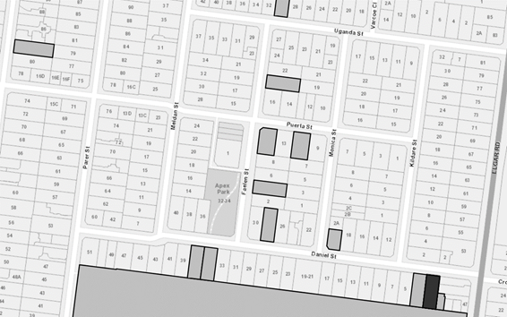
Subject site
|
|
13 Objector Properties
|
é
North
|
BACKGROUND
History
There are no previous planning
applications for the subject site.
Section 57A amendment
Subsequent to the advertising
period and prior to the Consultation Forum, a Section 57A amendment was lodged on 31 August 2020 to address issues raised by planning officers.
The changes made demonstrate a scaling back in built form and intensity, and
are listed below:
· Reduction
in the total number of student accommodation units from 14 to 10.
· Reduction
in ground and first floor built form to provide additional communal open space
at the rear, and achieve a consistent built form character outcome.
· Relocation
of site services such as waste and bicycle parking to improve access and
streetscape presentation.
· Additional
front setback landscaping.
The amended plans did not require
re-advertising as they are not considered to cause further material detriment
to any person as the amended proposal represents a scaling back in the
intensity of the use and development with less rooms proposed, and a reduction
in the built form at the ground and first floor levels.
However, the amended plans were
recirculated to all objecting parties via email, three weeks prior to the
consultation forum being held, providing an opportunity to view the additional
material.
The Site and Surrounds
The site is located on the southern
side of Daniel Street in Burwood. The site has a frontage of 15.24 metres
to Daniel Street, and a maximum depth of 38.02 metres, and a total site area of
589sqm.
The site maintains a relatively
flat topography, with a north-south orientation and currently contains a single
storey, brick rendered dwelling. The subject site includes a number of trees
and smaller shrubs around its periphery. There is a 3.05 metre drainage and
sewerage easement at the rear of the site, with a 224mm Yarra Valley sewerage
pipe.
The site abuts Presbyterian Ladies
College (PLC) to the rear, and is approximately 100 metres from Deakin
University to the east, and as such is within a ‘preferred
location’ as per the Clause 22.14 Student Accommodation policy. The site
is also within proximity to both Gardiners Creek Reserve and Wattle Park, 160
metres to the east and 520 metres to the north respectively. Other amenities
include the Burwood Village activity centre which affords a number of retail,
entertainment and food and drink premises.
The site is located within
proximity to a number of key arterials including Elgar Road to the east,
Riversdale Road to the north and Burwood Highway to the south as well as Tram
Routes 70 along Riversdale Road and 75 along Burwood Highway.
The surrounding properties are
typically residential, comprising a mix of single and double storey dwellings.
There are number of established and recent multi-dwelling developments evident
in the area. The subject land is located within the General Residential Zone
(GRZ), and it is evident that the wider area is evolving to accommodate
additional housing intensification.
Cultural Heritage Sensitivity
Area
The subject site is located within
an area of cultural heritage sensitivity. The applicant has submitted an
Aboriginal Heritage Due Diligence Report prepared by Heritage Insight Pty Ltd
concluding that a Cultural Heritage Management Plan (CHMP) is not required, as
the property is likely to have undergone significant ground disturbance as a
result of historic subdivision. Planning officers have reviewed the report and
agree with the conclusion, and as such a CHMP is not required.
Planning Controls
General Residential Zone –
Schedule 4
In accordance with Clause 32.08-2
and Clause 32.08-6 of the General Residential Zone, a Planning Permit is
required to use the land for a residential building and to construct a
residential building.
Significant Landscape Overlay
– Schedule 9
In accordance with Clause 42.03 of
the Significant Landscape Overlay – Schedule 9, a Planning Permit is
required to destroy, remove or lop a tree.
This does not apply to (inter
alia):
· A
tree that has both:
o A height less than 5
metres; and
o A single trunk
circumference of less than 1.0 metre at a height of 1 metre above ground level.
· A
tree that is less than 3 metres from the wall of an existing Dwelling or an
existing Dependent Person’s Unit when measured at ground level from
outside of the trunk.
· A
tree that is an Environmental Weed species (as per the specified list).
In addition, a planning permit is
also required to construct a building or construct or carry out works for:
· A
front fence that is within 4 metres of any trees that require a permit to be
removed.
· To
construct a building or carry out works within 4 metres from the base of any
tree protected under the provisions of Schedule 9.
PROPOSAL
The application proposes the use
and development of the land for a residential building (student accommodation),
the removal of protected trees and buildings and works within 4 metres of
protected trees. Detail of the proposal are nominated as follows:
Use and development
It is proposed to construct a
double storey residential building for the purposes of student accommodation
(total of ten units).
At ground floor, the building will
comprise of four (4) student accommodation units (varying in size and layout) a
bathroom, bicycle and bin storage, rear communal open space and a double garage.
At first floor, the building will comprise six (6) student accommodation units
(varying in size and layout) accessed via a stairwell.
Each unit would have a minimum area
of 23sqm, with the provision of a single bed, lounge, cooking facilities and
bathroom. Each unit will be accessed via a central corridor.
Pedestrian access is from the
building frontage to Daniel Street, with a secondary side access within the
services area to the western boundary. Vehicle access will be provided from the
existing concrete crossover into Daniel Street.
Landscaping is proposed to front,
side and rear site boundaries with the provision of seven (7) proposed canopy
trees. A 0.9 to 1.2 metre high horizontal batten fence is proposed across the
frontage, integrated with a 1.5 metre high services cupboard and mailbox
structure.
Tree removal and buildings and
works
It is proposed to remove all trees
and tree groups from the site. Trees on neighbouring properties and on the
nature strip are to be retained. Trees requiring a planning permit pursuant to
the Significant Landscape Overlay – Schedule 9 are trees 2, 3, 4, 7 and
11, which are described further in Table 1 below:
Table 1 – proposed tree
removal (information as described by applicant’s arborist)
|
Tree #
|
Species
|
Common name
|
Height
|
Spread
|
Value
|
|
2
|
Pittosporum eugeniodes
|
Tarata
|
6m
|
5m
|
Low
|
|
3
|
Lagerstroemia indica
|
Crepe myrtle
|
6m
|
3m
|
Low
|
|
4
|
Cordyline australis
|
Cabbage tree
|
6m
|
2m
|
Low
|
|
7
|
Acacia baileyana
|
Cootamundra wattle
|
7m
|
2m
|
Low
|
|
11
|
Eucalyptus botryoides
|
Southern mahogany
|
14m
|
10m
|
Low
|
In addition to the removal of
trees, the application also includes buildings and works within 4 metres of
Tree 1 on the nature strip, and with proximity to neighbouring tree groups 9
and 10. The nature of the buildings and works includes the construction of the
residential building, the construction of a front fence, the provision of hard
paving and the provision of site cut and fill. These are further described in
Table 2 below:
Table 2 – Trees in
proximity to development.
|
Tree #
|
Species
|
Common name
|
Location
|
Encroachment
|
|
1
|
Banksia marginate
|
Silver Banksia
|
Street tree
|
< 10%
|
|
9
|
Pittosporum tennuifolium
|
Kohuhu
|
Neighbours tree
|
< 10%
|
In assessing buildings and works
within 4 metres of a protected tree, both Council’s arborist and
Parkswide have indicated that the proposed buildings and works near the trees
is acceptable as encroachment into the TPZ is less than 10%.
CONSULTATION
Public Notice
The application was advertised by
mail to the adjacent and nearby property owners and occupiers and by erecting
notices to the Daniel Street frontage. Following the advertising period
thirteen (13) objections were received.
The issues raised are summarised as
follows:
Neighbourhood Character
· Concerns
were raised that the design response did not respect the existing character of
the Garden Suburban 1 area, particularly with regards to bulk and massing,
height and detailed design.
Amenity Impacts
· Concerns
were raised in relation to overlooking into private open space and the use of
louvre screens in lieu of obscured glazing.
· Concerns
were raised in relation to overshadowing and loss of sunlight into abutting
secluded private open space.
Traffic and Car Parking
· Concerns
were raised that the number of car parking spaces on the site would not be
satisfactory for the use and development and together with the peak drop off
and pick up times with PLC, would result in traffic and parking impacts to the
wider road network.
· Concerns
were raised that the access and egress from the site would be detrimental to
pedestrians.
Waste
· Concerns
were raised that the use would increase the proliferation of waste and impact
the street network and surrounds.
Oversupply of accommodation
· Concerns
were raised that there is an oversupply of student accommodation which will
impact the residential character of the area.
All objections have been given due
consideration, with responses prepared under the assessment section of this
report.
Consultation Forum
A Consultation Forum was held by
Planning Officers on 8 October 2020. Approximately nine (9) objectors
attended the meeting.
All issues were explored in detail,
however no resolution was reached between the parties and all objections still
stand
Referrals
External
No external referrals are required
under the provisions of the Whitehorse Planning Scheme.
Internal
Asset
Report and consent to be required.
This will need to be satisfied through the building permit with civil and
drainage plans, and is not a matter to be considered through the planning
application.
Transport
Supported by Transport team.
Waste
Supported by Waste team.
Parkswide
Supported by Parkswide team,
subject to permit conditions for tree protection.
Arborist
Supported by Arborist, subject to
permit conditions around tree protection measures being included in any permit
issued.
ESD
Supported by ESD department,
subject to permit conditions.
DISCUSSION
The proposed development has been fully
assessed against and is considered to satisfy the relevant objectives of the
Planning Policy Framework, Local Planning Policy Framework; the purpose and
objectives of the General Residential Zone and Significant Landscape Overlay;
and the objectives of Two or More Dwellings on a lot.
Policy Framework
Broadly, the proposed use and
development will provide a diversity in housing typology, catering to the
anticipated demand for purpose built student accommodation units. The building
includes a range of services and facilities onsite, to ensure the amenity for
all students, with a built form outcome consistent with the relevant policy
framework for residential development and neighbourhood character, thus
satisfying the Planning and Local Planning Policy Frameworks.
The proposed use and development is
consistent with the relevant local policy for student accommodation at Clause
22.14 with the site located in the preferred location, being
approximately 100 metres from Deakin University, and purpose built for improved
student amenity, with all rooms designed in excess of the minimum standards.
Whilst the rooms do not have
individual balconies, the building proposes a substantial communal open space (152sqm
with a minimum dimension of 7.09 metres) area to the rear of the ground floor,
providing opportunities for social interaction and recreation. The building has
been designed to respond to the built form character of the Garden Suburban 1
area, presenting as a single dwelling along Daniel Street.
The site proposes substantial
canopy planting around the development, to complement the design of the
building and landscaping character of the wider area, but will also serve to
improve comfort and amenity within the communal open space. The site maintains
adequate parking spaces, with opportunities for alternative and sustainable
transport due to its proximity to bus and tram routes that service the
University.
The building has been designed to
improve student amenity with clear points of entry and clear sight lines through
the corridors, to avoid any safety conflict. Furthermore, the building has been
designed and sited to also avoid external amenity impacts, particularly from
overlooking and overshadowing to sensitive interfaces.
Should a permit be granted, conditions
to ensure that the building and use are subject to on-going management to avoid
impacts to the abutting and surrounding residential environs are recommended
and will be discussed in more detail later in this report.
Neighbourhood Character and
Landscaping
The objectives of Clause 55.02-1
seek to ensure that the design respects the existing neighbourhood character
or contributes to a preferred neighbourhood character. The proposal is
located within the Garden Suburban 1 area which is deemed an area of natural
change pursuant to Clause 22.03.
The Garden Suburban 1 preferred
character statements indicate that:
· Buildings
will be occasionally built to the side boundary, but appear to have side
setbacks with space for planting.
· The
formal character of the area will be enhanced by garden settings with tall
trees, lawns, garden beds and shrubs.
· A
sense of spaciousness will be established and enhanced with consistent front
and side setbacks.
In reviewing the site and the
surrounding context, the proposal respects both the existing and preferred
built form and landscape character of the Garden Suburban 1 area.
The proposed buildings massing and
built form responds to the topography of the site and its adjoining context,
with substantial front, side and rear setbacks at the ground and first floor,
to maintain a presentation of spaciousness, and to allow landscaping
opportunities to occur. The building proposes a consistent built form profile to
the abutting dwelling to the west, with a consistent first floor massing and
setback to the rear, to limit visual bulk and massing to the sensitive
interfaces.
The front setback has been designed
to limit hard paving where practical, with areas available for vehicle turning,
but maintaining a substantial front garden setting with the provision of
several canopy trees and understorey shrubbery to enhance the landscape setting
of the streetscape. The rear setback is open and spacious, maintaining the rear
spine of open space pattern along Daniel Street and provides opportunities for
excellent communal open space for future occupants. Permit conditions would
require improvements to the open space to allow for additional seating and
amenities.
The provision of substantial
planting across the site seeks to both soften the building’s form, and
enhance the existing landscape setting of the wider area, with seven (7) canopy
trees proposed to the front, side and rear boundaries within well-proportioned
setback areas to ensure establishment to maturity. Permit conditions will
require that trees to the side setback are capable of growth within confined
spaces (i.e. fastigiated varieties or like species).
The building presents as a
standalone double storey dwelling, with a contemporary form and consistent
materiality to more recent development in the area to maintain a low profile in
the streetscape.
Overall, it is considered that the
proposed building respects elements of the existing and emerging character of
the area, but also aligns itself with the preferred character statement of the
Garden Suburban 1 area.
Tree Removal and Protection
Tree removal and buildings and
works have been considered by Council’s Arborist and Parkswide
department.
Council’s arborist has determined
trees proposed for removal are all of low retention value due to either
species, health or structure, with no further objections, subject to permit
conditions to ensure protection of neighbouring trees.
In addition, Council’s
Parkswide department has determined the works within proximity to the street
tree are acceptable with no further objections, subject to permit conditions to
ensure protection of the street tree.
Landscaping and planting
opportunities are in accordance with the policy provisions of Clause 22.04 for
regeneration and replacement, to ensure that all new trees have the opportunity
to establish to maturity and improve upon the established landscaping setting
of the area.
Amenity Impacts and ResCode
It has been determined that the proposal
satisfies all standards and objectives of ResCode pursuant to Clause 55.
However, specific assessment against the relevant external amenity standards of
Clause 55.04 have been addressed below, determining that the proposal will not
result in unreasonable offsite impacts to adjoining and surrounding
developments.
Side and rear setbacks
The building has been designed to
meet the minimum side and rear setbacks under Standard B17 – Side and
Rear Setbacks to limit visual bulk and massing and ensure the proposal
respects the existing character of the Garden Suburban 1 area. The objectives
and standards of Clause 55.04-1 have been met.
Walls on boundary
There are no walls proposed on the
boundary, with minimum setbacks of 1.21 metres to the eastern boundary and 1.6
metres to the western boundary, providing opportunities for both landscaping
and pedestrian access. The objectives and standards of Clause 55.04-2 have been
met.
Daylight to existing windows
The building has been designed to
maintain clearances to existing windows under Standard B19 – Daylight
to Existing Windows to allow for daylight access. The objectives of
standards of Clause 55.04-3 have been met.
Overshadowing
There are no overshadowing impacts
(as demonstrated in the shadow diagrams) that would result in excessive or
additional overshadowing to immediately adjoining existing secluded private
open space areas in accordance with Standard B21 - Overshadowing. The
objectives and standards of Clause 55.04-5 have been met.
Overlooking
The first floor windows of the
building are treated to limit overlooking and include highlight windows,
obscured windows or windows with an externally fixed screen. These all satisfy
the minimum standards for overlooking under Standard B22 - Overlooking.
The privacy screens have been designed with horizontal slats with a maximum
transparency of 25% to limit overlooking. The objectives and standards of
Clause 55.04-5 have been met.
Noise impacts
There are no noise sources such as
mechanical plants that are located within proximity to bedrooms of immediate
adjacent existing dwellings. A student management plan would be required
through conditions to manage offsite impacts such as noise to ensure
consistency with the policy objectives outlined under Clause 22.14 which seek
to ensure that student accommodation is subject to on-going management and used
in a manner to limit offsite amenity impacts. The objectives and standards of
Clause 55.04-6 have been met.
Car and Bicycle Parking
Pursuant to Clause 52.05-6, where a
use of land is not specified in Table 1, car parking spaces must be provided to
the satisfaction of the Council. A residential building is not specified within
Table 1.
It is policy under Clause 22.14 to
encourage the provision of car parking in accordance with the needs of
students. Council will consider the circumstances of each proposal on its
merits. Generally, for a development designed as a residential building and
within 500 metres of a tertiary education (such as this application), a car
parking rate of at least 0.25 spaces per bed would be required. At least
2.5 spaces would be required, rounding up to 3 in total.
The application proposes two (2)
car parking spaces within a double garage and although the proposal does not
accord with the policy preference for student accommodation, there is general
policy support to reduce reliance on private vehicle parking in this location
which is offered good access to public transport alternatives and the
University itself which is within comfortable walking distance from the subject
site.
The proposed condition for a
Section 173 Agreement under Condition 8 further stipulates that the number
of students residing on site who own cars must not exceed the number of on-site
car spaces provided by the development to further limit opportunities for
parking on the site, encouraging students to seek alternative options. This
outcome is consistent with the policy direction under clause 22.14-3 which
requires landowners to enter into this type of Agreement.
The objective of Clause 18.02-1S
seeks to promote the use of sustainable personal transport with
strategies that seek to encourage the use of walking and cycling, and provide
appropriate facilities for bicycle parking and storage.
In addition, it is policy under
Clause 22.14 to ensure the provision of adequate areas for visitor and secure
resident bicycle storage, at a rate of one long term resident bicycle space per
3 beds. A total of 3 spaces would be required, with 6 parking spaces being
provided, with two visitor spaces.
As such, whilst the proposal does
not meet the parking rate as suggested in the policy, the proximity of the site
to the University and excess provision of bicycle parking provides excellent
opportunity for the uptake of alternative transport, and reduces reliance on
private vehicle transportation.
As such, the current parking rate
for the use and development is acceptable.
Response to Objector Concerns
Neighbourhood Character
· Concerns
were raised that the design response did not respect the existing character of
the Garden Suburban 1 area, particularly with regards to bulk and massing,
height and detailed design.
Response: Neighbourhood
character has been considered within this report and it has been determined
that the proposed building is consistent with the existing and preferred
character of the Garden Suburban 1 area with respect to built form, height,
massing, setbacks and landscaping.
Amenity Impacts
· Concerns
were raised in relation to overlooking into private open space and the use of
louvre screens in lieu of obscured glazing.
· Concerns
were raised in relation to overshadowing and loss of sunlight into abutting
secluded private open space.
Response: Overlooking and
overshadowing have been considered within this report, demonstrating compliance
with the minimum standards and meeting the intent of the objectives to limit
amenity impacts from overlooking and overshadowing.
Traffic and Car Parking
· Concerns
were raised that the number of car parking spaces on the site would not be
satisfactory for the use and development and together with the peak drop off
and pick up times with PLC, would result in traffic and parking impacts to the
wider road network.
· Concerns
were raised that the access and egress from the site would be detrimental to
pedestrians.
Response: Traffic and car
parking have been considered within this report, demonstrating that whilst the
number of car parking spaces is below the preferences outlined within the
policy, that the site is within a preferred location for student housing with
alternative transport options available to any residents.
Waste
· Concerns
were raised that the use would increase the proliferation of waste and impact
the street network and surrounds.
Response: A waste referral
response has been received with no objections. The applicant has submitted a
waste management plan demonstrating an adequate outcome that seeks to broadly
minimise waste, and limit spread of litter from the boundaries of the site.
Oversupply of accommodation
· Concerns
were raised that there is an oversupply of student accommodation which will
impact the residential character of the area.
Response: The site is situated
in a preferred location under Clause 22.14, within 250 metres of Deakin
University. The policy suggests that there is a demand for good student
housing, and this proposal is representative of that need. Further to this, it
is reasonable to expect that a land owner, prior to proposing use and
development of this nature, has done the appropriate research to determine the
market need, especially given the specific building requirements for student
housing, which are not easily retrofitted for another use.
CONCLUSION
The proposal for the use and
development of the land for a residential building (student accommodation), the
removal of protected vegetation and buildings and works within 4 metres of
protected vegetation is an acceptable response that satisfies the relevant
provisions contained within the Whitehorse Planning Scheme.
The proposal is consistent with the
Planning Policy Framework and Local Planning Policy Framework applicable to the
site, particularly with regards to built environment, housing diversity and
demand for student accommodation.
The proposed building has been
sensitively designed to respect and achieve an outcome that maintains
consistency with the existing and preferred future character of the Garden
Suburban 1 area, thus maintaining consistency with the purpose of the General
Residential Zone. The building has been assessed against the provisions of ResCode
with all objectives being met, avoiding amenity impacts to adjoining or nearby
properties.
The site is well located within
close proximity to Deakin University to take advantage of sustainable personal
transport and to minimise potential traffic and parking impacts to the street
and surrounding road network. The provision of two car parking spaces on the
site is considered acceptable, and consistent with the Local Planning Policy
Framework.
A total of thirteen (13) objections
were received as a result of public notice and all of the issues raised have
been discussed as required.
It is considered that the
application should be approved.
Attachment
1 Additional
Information - Amended Plans 
Council Meeting 27
January 2021
9.1.2 353-383
Burwood Highway, Forest Hill (LOT 2 PS 407904L) Construction of two six (6)
storey commercial (office and retail) buildings, removal of native vegetation
(under Clause 52.17) and alteration of access to a Road Zone Category 1
FILE NUMBER: WH/2019/806
ATTACHMENT
SUMMARY
This application was advertised, and a total of 10
objections were received. The objections raised issues with neighbourhood
character, overdevelopment, amenity issues including overlooking, noise and
wind impacts, car parking provision, traffic congestion, construction impacts,
loss of trees and extent of new landscaping. A Consultation Forum was held on 27
February 2020 chaired by (former) Councillor Bill Bennett where issues were
explored however no resolution was reached between the parties. This report
assesses the application against the relevant provisions of the Whitehorse
Planning Scheme, recommendations of referral authorities as well as the
objector concerns. It is recommended that the application be supported, subject
to conditions.
RECOMMENDATION
That Council:
A. Being the
Responsible Authority, having caused application WH/2019/806 for 353-383
Burwood Highway, FOREST HILL (LOT 2 PS 407904L) to be advertised and having
received and noted the objections is of the opinion that the granting of a
Planning Permit for the construction of two six (6) storey commercial (office
and retail) buildings, removal of native vegetation (under Clause 52.17) and
alteration of access to a Road Zone Category 1 is acceptable and should not
unreasonably impact the amenity of adjacent properties.
B. Issue a Notice of Decision to Grant a
Permit under the Whitehorse Planning Scheme to the land described as 353-383 Burwood Highway, FOREST HILL (LOT 2 PS
407904L) for the construction of two six (6) storey commercial (office and
retail) buildings, removal of native vegetation (under Clause 52.17) and
alteration of access to a Road Zone Category 1, subject to the following
conditions:
1. Before the development starts, or any trees or
vegetation removed, amended plans and documents must be submitted to in a
digital format and approved by the Responsible Authority. The plans must
be drawn to 1:100 scale, with dimensions, and be generally in accordance with
the plans identified as Revision F prepared by Elenberg Fraser, dated 31
October 2019, but modified to show:
a) The
locations of the Tree Protection Zones described in Tree Management Plan
required by Condition 5.
b) A 20
metre building exclusion zone extending from the northern boundary (into the
subject site) between Springvale Road and western property boundary for the
protection of trees and landscaping.
c) Indicative
future internal access corridor and associated sign in accordance with
Condition 19.
d) The
location of all service trenches to serve the buildings (for example: gas,
water, electricity, stormwater, sewerage, telecommunications), including the
extent of trenching required in easements over adjoining lots (if any) and the
locations of protected trees within 4 metres of these trenches (if
any). The service trenches must be located and hand dug or bored to
ensure that protected trees are not damaged, to the satisfaction of the
Responsible Authority.
e) Development
plans to reflect all sustainability features indicated in the Endorsed
Sustainability Management Plan (SMP) and those specified under ‘permit
notes’ to this permit. Where features cannot be visually shown,
include a notes table providing details of the requirements (i.e. energy and
water efficiency ratings for heating and cooling systems, plumbing fixtures
etc.). The plans are to be generally in accordance with the plans
submitted indicating unless otherwise provided to the satisfaction of the
Responsible Authority.
f) Roof
plan illustrating all plant and equipment with screening ensuring views from
all street frontages and residential properties to the north are obscured.
g) A
detailed materials and finishes schedule including methods to reduce any glare
or reflectivity of the external surface to the northern elevation.
h) Amended
Landscape Plan to include:
i. Raised
garden beds in internal areas (central plaza) include some small trees to
enhance amenity and reduce a wind tunneling effect and be reduced in size to
cater for tables and seating associated with the café and food and drink
premises.
ii. Terraces
to western façade with privacy screen.
iii. Additional
shrubs and ground-level planting along the eastern interfaces.
iv. Reduce pot
sizes for canopy trees to reduce root stress. 1.5m in height for trees
should be sufficient.
v. Reduce
planting density for Cassinia aculeata
vi. Swap Melaleuca
alternifolia for a local species for the north interface revegetation planting,
a mix of Acacias may be a better reflection of the original vegetation
structure. Acacia implexa, Acacia mearnsii and Acacia pycnantha could be
used here.
vii. A diversity of
tube-stock understorey planting under the existing trees. This shall
require some specialists maintenance work during the establishment period.
viii. Specify that Corymbia
citriodora ‘Scentuous’ and Banksia marginata will be the trees that
will be used in the Central Plaza.
ix. Limit
up-lighting to the Central Plaza and Zone 1 if there is the goal to support
native animals in Zones 3, 4 and 5.
x. Avoid Poa
poiformis near outdoor seating spaces sue to high pollen load.
xi. Water shed
from the carparks into the garden beds and create some rain gardens.
xii. Location of the
bird bath where it can be viewed from the Central Plaza. Maintenance
regime should be included in final landscape plan.
xiii. Callout symbols to all
proposed plants in the landscape plan and total numbers for each species in the
planting schedule.
i) A
landscape maintenance plan in accordance with Condition 3
j) A
Tree Protection Plan (drawing) and Tree Management Plan (report) in accordance
with Condition 5.
k) Amended
Sustainability Management Plan (SMP) in accordance with Condition 7.
l) A
Construction Management Plan (CMP) in accordance with Condition 9.
m) Car Parking
Management Plan (CPMP) in accordance with Conditions 22 and 23
All of the
above must be to the satisfaction of the Responsible Authority. Once approved,
these plans and documents form part of this permit.
2. The layout of the site and the size, design and
location of the buildings and works permitted must always accord with the
endorsed plan and must not be altered or modified without the further written
consent of the Responsible Authority.
Landscaping
and Tree Protection
3. Prior to the commencement of the development, a
Landscaping Maintenance Plan, prepared by a suitably qualified professional,
must be submitted to and approved by the Responsible Authority. The
landscaping maintenance plan must include, but is not limited to:
a) Irrigation system for all trees and
landscaping, including details of frequency and water delivery method.
b) Details of the ongoing maintenance procedures
to ensure that the garden areas remain healthy and well maintained to the
satisfaction of the Responsible Authority. This must include:
i. Irrigation frequency and delivery method.
ii. Drainage.
iii. Pruning and mulching.
Once
approved, this plan forms part of this permit.
4. Prior to the occupation of the approved buildings, landscaping and
tree planting must be undertaken in accordance with the endorsed landscape plan
that forms part of this permit, to the satisfaction of the Responsible
Authority.
5. A Tree Management Plan (TMP) written in accordance with AS4970-2009
must be submitted to Council prior to the commencement of all buildings and
works. The report must detail how all trees shown to be retained on the plans
will be protected pre, during and post-construction. The TMP must be to the
satisfaction of the Responsible Authority (RA) and written by a qualified
arborist with a minimum Diploma Qualification in Horticulture (Arboriculture).
6. Unless
otherwise agreed in writing by the Responsible Authority all protection
measures identified in the Tree Management and Protection Plan must be
implemented and maintained in effective condition until completion of works,
and development works undertaken on the land must be undertaken in accordance
with the Tree Management and Protection Plan, to the satisfaction of the
Responsible Authority.
Sustainability
Management Plan (SMP)
7. Prior to
the commencement of any buildings, an amended Sustainability Management Plan (SMP)
must be submitted to and approved by the Responsible Authority. This SMP
must be generally in accordance with the SMP submitted with the application and
amended to include, unless otherwise provided to the satisfaction of the
Responsible Authority:
i. A STORM Assessment or equivalent
addressing stormwater quality performance, in addition to ensuring that the
Responsible Authority’s collective integrated water management
expectations and requirements pursuant to Clauses 34 and 44 of the State Environment
Protection Policy (Waters), are satisfied.
ii. A Green Star Design & As Built Design v
1.2 or 1.3 Scorecard Assessment which meets or exceeds an overall score of 60
points, and demonstrates compliance with Council’s ESD Policy objectives
to the satisfaction of the Responsible Authority.
iii. A Preliminary National Construction Code
(NCC) 2019 Building Code of Australia (BCA) Section J or JV3 Energy Efficiency
Assessment indicating a 10% improvement in energy efficiency performance with
respect to the development’s reference/base case. The assessment is
required to include indicative commitments
towards thermal performance (i.e. R-values), artificial lighting and glazing
(indicating U- and SHGC- values).
iv. Daylight
modelling assessment to the satisfaction of the Responsible Authority.
v. Double
glazing for all external windows.
vi. Control
car park ventilation with CO sensors.
vii. Control
car park lighting, where reasonably safe to do so, with motion sensors or
timers.
viii. Control
all common, external, service and lift area lighting with sensors or timers.
ix. Control
common, service and lift area ventilation with sensors or timers.
x. Provide
energy efficient heating, cooling and hot water systems indicating the
associated COP and EER values or energy efficiency star ratings.
xi. Include
a minimum 190 kW renewable energy photovoltaic system.
xii. Provide
water efficient fixtures and appliances indicating the associated WELS ratings.
xiii. Divert
at least 80% of construction and demolition waste from landfill.
Once
submitted and approved to the satisfaction of the Responsible Authority, the
SMP will form part of the endorsed plans under this permit.
8. The
requirements of the SMP must be implemented by the building manager, owners and
occupiers of the site when constructing and fitting out the building, and for
the duration of the building operation in accordance with this permit, to the
satisfaction of the Responsible Authority.
Construction
Management Plan
9. Prior to
the commencement of buildings or works on the land (including vegetation
removal), a detailed Construction Management Plan (CMP), prepared by a suitably
qualified and experienced professional, detailing how the developer will manage
the environmental and construction issues associated with the development, must
be submitted to and approved by Council.
The CMP is to be to the
satisfaction of the Responsible Authority and must be prepared in accordance
with the City of Whitehorse Construction Management Plan Guidelines. Once
submitted to and approved by the Responsible Authority the CMP will form part
of this planning permit.
This CMP may be staged and is
to consider the following, amongst other matters deemed relevant by the
Responsible Authority:
a) Public
safety, amenity and site security;
b) Operating
hours;
c) Noise
and vibration controls, with particular reference to the potential impact of
noise and vibration to the building occupied by the Emergency Services
Telecommunications Authority (ESTA). To properly assess the potential impact of
noise and vibration to the building occupied by ESTA, an acoustic report by a
suitably qualified person must accompany the Demolition and Construction
Management Plan;
d) Air
and dust management;
e) Stormwater
and sediment control;
f) Waste
and material reuse;
g) Construction
traffic management;
h) Set
out any measures required for the staging of the development, including interim
or temporary site management car parking provision, and temporary treatment of
public realm spaces;
When approved the CMP will
form part of this permit and must be complied with, to the satisfaction of the
Responsible Authority, to the extent that this is in the control of the owner
of the land. The owner of the land is to be responsible for all costs associated
with the works to be undertaken in accordance with the requirements of the CMP.
Asset Engineering
10. All stormwater
drains and on-site detention systems are to be connected to the legal point of
discharge to the satisfaction of the Responsible Authority prior to the
occupation of the building/s. The requirement for on-site detention will
be noted on your stormwater point of discharge report, or it might be required
as part of the approval of the civil plan.
11. Detailed
stormwater drainage and/or civil design for the proposed development are to be
prepared by a suitably qualified civil engineer and submitted to the
Responsible Authority for approval prior to occupation of the
development. Plans and calculations are to be submitted with the application
with all levels to Australian Height Datum (AHD). All documentation is to
be signed by the qualified civil engineer.
12. Stormwater
that could adversely affect any adjacent land shall not be discharged from the
subject site onto the surface of the adjacent land.
13. Prior to works
commencing the Applicant/Owner is to submit design plans for all proposed
engineering works external to the site. The plans are to be submitted as
separate engineering drawings for assessment by the Responsible
Authority.
14. The
Applicant/Owner is responsible for paying for all costs associated with
reinstatement and/or alterations to Council or other Public Authority assets as
a result of the development. The Applicant/Owner is responsible for
obtaining all relevant permits and consents from Council at least 7 days prior
to the commencement of any works on the land and is to obtain prior specific
written approval for any works involving the alteration of Council or other
Public Authority assets. Adequate protection is to be provided to
Council’s infrastructure prior to works commencing and during the
construction process.
15. The qualified
civil engineer, when undertaking civil design, must ensure that the landscape
plan/s and drainage plan/s are compatible. The stormwater drainage and
on-site detention system must be located outside the tree protection zone (TPZ)
of any trees to be retained.
Waste Management Plan
16. Waste
collections for this development are to be completed internally by Private
waste collection contractor.
17. Council issued
bins will not be required for this development.
18. Waste
collection vehicles are to enter and leave the developed site in a forward
direction.
19. MGB usage is
to be shared by the occupiers of the development.
20. Councils
Traffic Engineering Dept. are required to assess the suitability of the
proposed waste vehicle access to and from the development as well as the
vehicle movements within the development.
21. The approved
WMP will be the model for adoption in this development and the design &
as-built aspects needs to account for what is approved in the WMP. Any
revision of the WMP or changes to the approved waste system of the development requires Council approval.
Car Parking
Management Plan (CPMP)
22. Prior to the
commencement of any buildings or works, a Car Parking Management Plan (CPMP),
detailing how the car and bicycle parking areas, accessways and waste
collection bays will be allocated and managed, must be submitted to and
approved by the Responsible Authority.
23. The CPMP is to
be to the satisfaction of the Responsible Authority and must include, but is
not limited to, the following:
a) Allocation
of all parking spaces to the individual tenancies.
b) Pedestrian access and
movement within the car parking areas, including strategies to minimise the
potential for conflict between pedestrians and vehicles. This may include line
marking such as hatched shared areas, direction signs and/or physical barriers.
c) Allocation of bicycle
spaces to tenancies and visitors.
d) Directional signs to car
and bicycle parking spaces and facilities.
e) Location of bicycle
parking signs in accordance with Clause 52.34-5.
f) Line marking of
parking spaces.
g) How parking will be
secured and details of how access to car spaces, disabled car spaces and
bicycle spaces will be achieved by visitors and delivery vehicles as required
(via an intercom).
h) Details of how access to
the waste collection areas will be achieved by waste collection vehicles and
how these areas will be secured.
i) Advise where
delivery vehicles and moving vans serving the dwellings will park. These
vehicles must be able to park for a reasonable period of time in convenient
locations.
j) How the car park
will be managed to ensure that all vehicles exit the site in a forwards
direction.
Once
submitted to and approved by the Responsible Authority, the CPMP will form part
of the documents endorsed as part of this planning permit. The recommendations
of the CPMP must be implemented to the satisfaction of the Responsible
Authority.
Department
of Transport Conditions
24. Prior to the
commencement of the buildings and works, amended plans must be submitted to and
approved by the Head, Transport for Victoria. When approved by the Head,
Transport for Victoria, the plans must be endorsed by the Responsible Authority
and will then form part of the permit. The plans must be drawn to scale with
dimensions. The plans must generally be in accordance with the plans date
stamped 31/10/19 and annotated Project Number 19030 Revision G but modified to
show:
a) Indicative
future internal access corridor from Springvale Road near the north of the
site, consistent with the Tally Ho Major Activity Centre Urban Design
Framework.
b) Installation of a standard
left-turn only sign (left arrow with word ‘only’ below –
refer to DoT website) and associated pavement marking facing exiting traffic at
the Springvale Road access.
25. Prior to the
occupation of the development, the installation of the 'left turn only' sign
and associated pavement marking must be completed to the satisfaction of and at
no cost to the Head, Transport for Victoria.
26. Within 6
months of the development operating to full capacity, a post-development Transport Impact Assessment report must be submitted to
and approved by the Head, Transport for Victoria and the Responsible Authority.
The Transport Impact Assessment must:
a) Identify any operational issues at
the Burwood Highway / Woodvale Court intersection post-development.
b) Recommend appropriate phasing
modifications to the traffic signals that are required to address the
identified operational issues.
27. Unless
otherwise agreed in writing by the Head, Transport for Victoria, within 12
months of the development operating at full capacity, the mitigation measures
outlined in the post-development Transport Impact Assessment report must be
implemented to the satisfaction of and at no cost to the Head, Transport for
Victoria.
28. The demolition
and construction of the development must not disrupt bus operations along Springvale
Road without the prior written consent of the Head, Transport for Victoria.
29. Any request
for written consent to disrupt bus operations on Springvale Road during the demolition and construction of the development must be submitted
to the Head, Transport for Victoria not later than 8 weeks prior to the planned
disruption and must detail measures that will occur to mitigate the impact of
the planned disruption.
Department of
Environment, Land, Water and Planning Conditions
30. Before works start, the permit holder must advise all persons
undertaking the vegetation removal or works on site of all relevant permit
conditions and associated statutory requirements or approvals.
31. The total area of native vegetation proposed to be removed totals
0.578 hectares, comprised of:
a) 1 patch of native vegetation
with a total area of 0.471 hectares [containing 3 large trees],
b) 1 large scattered tree,
c) 2 small scattered trees.
32. To offset the permitted clearing in accordance with Guidelines for
the removal, destruction or lopping of native vegetation (DELWP 2017), the
permit holder must secure a general offset of 0.191 general habitat units:
a) Located within the
Port Phillip and Westernport Catchment Management boundary or Whitehorse
municipal area.
b) With a minimum strategic
biodiversity score of at least 0.152
The offsets secured must also protect 4 large trees.
33. Before any native vegetation is removed evidence that the required
offset by this permit has been secured must be provided to the satisfaction of
the Responsible Authority. This evidence must be one or both of the following:
a) An established first-party offset
site including a security agreement signed by both parties, and a management
plan detailing the 10-year management actions and ongoing management of the
site, and/or
b) Credit extract(s) allocated to the
permit from the Native Vegetation Credit Register.
34. A copy of the offset evidence will be endorsed by the responsible
authority and form part of this permit. Within 30 days of endorsement of the
offset evidence, a copy of the endorsed offset evidence must be provided to
Planning Approvals at the Department of Environment, Land, Water and Planning
Port Phillip regional office.
35. Where the offset includes a first-party offset(s), the permit holder
must provide an annual offset site report to the responsible authority by the
anniversary date of the execution of the offset security agreement, for a
period of 10 consecutive years. After the tenth year, the landowner must
provide a report at the reasonable request of statutory authority.
36. Within 6 months of the conclusion of the permitted clearing of
native vegetation under this permit, the offset requirements can be reconciled
with the written agreement of the responsible authority and the Department of
Environment, Land. Water and Planning.
37. A suitably qualified wildlife
handler or zoologist is to be present when felling trees/removing native
vegetation, to ensure affected wildlife is not harmed. If displaced wildlife
that cannot be relocated on-site to an appropriate location away from the
construction footprint, or injured wildlife is captured, please contact DELWP
on 136 186 for further advice.
Section 173
Agreement
38. Prior to the commencement of any buildings and works, the owner of
the land shall enter into an Agreement with the Responsible Authority under
Section 173 of the Planning and Environment Act 1987 which covenant that no
buildings shall be constructed in areas designated as ‘building exclusion
zone’ on the Endorsed Plans.
This Agreement
is to be prepared to the satisfaction of the Responsible Authority at the
owner’s expense and will be recorded on the folio of the register
relating to the site. The owner must pay all costs and expenses of, and
incidental to, the preparation, checking, lodgment and enforcement of this
Agreement.
Permit Expiry
39. This permit will expire if one of the following circumstances
applies:
a) The development is not commenced within three
(3) years from the date of issue of this permit;
b) The development is not completed within five
(5) years from the date of this permit;
The
Responsible Authority may extend the periods referred to if a request is made
in writing pursuant to the provisions of Section 69 of the Planning and
Environment Act 1987.
Permit Notes:
Asset Engineering:
a) The
design and construction of the stormwater drainage system up to the point of
discharge from an allotment is to be approved by the appointed Building
Surveyor. That includes the design and construction of any required stormwater
on-site detention system. The Applicant/Owner is to submit certification of the
design of any required on-site detention system from a registered consulting
engineer (who is listed on the Engineers Australia National Professional
Engineer Register or approved equivalent) to Council as part of the civil plans
approval process.
b) The
requirement for on-site detention will be noted on your stormwater point of
discharge report, or it might be required as part of the approval of the civil
plan.
c) All
proposed changes to the vehicle crossing are to be constructed in accordance
with the submitted details, Whitehorse Council’s – Vehicle Crossing
General Specifications and standard drawing.
d) Report
and consent – Any proposed building over the easement is to be approved
by the Responsible Authority prior to the approval of the building permit. If
Report and Consent contradicts with the Planning Permit, amendment of the
Planning Permit might be required.
e) The
Applicant/Owner is to accurately survey and identify the design plans all
assets in public land that may be impacted by the proposed development. The assets
may include all public authority services (i.e. gas, water, sewer, electricity,
telephone, traffic signals etc.) and the location of street trees or
vegetation. If any changes are proposed to these assets, then the evidence of
the approval is to be submitted to Council, and all works are to be funded by
the Applicant/Owner. This includes any modifications to the road reserve,
including footpath, nature strip and kerb and channel.
f) The
Applicant/Owner must obtain a certificate of hydraulic compliance from a
suitably qualified civil engineer to confirm that the on-site detention works
have been constructed in accordance with the approved plans, prior to Statement
of Compliance is issued.
g) There
is to be no change to the levels of the public land, including the road reserve
or other Council property as a result of the development, without the prior
approval of Council. All requirements for access for all-abilities (Disability
Discrimination Access) are to be resolved within site and not in public land.
h) No
fire hydrants that are servicing the property are to be placed in the road
reserve, outside the property boundary, without the approval of the Relevant
Authority. If approval obtained, the property owner is required to enter into
an S173 Agreement with Council that requires the property owner to maintain the
fire hydrant”.
i) Floor
levels need to be amended if vehicle access to the garage cannot be achieved.
j) The
architect and/or designer must ensure that vehicle access is to conform to the
Australian Standards for Off-Street Parking (AS/NZS 2890.1:2004).
k) Planning
Permit is required for works near significant trees. Please contact the
Council Planning Department
on 9262 6303 for information.
Department
of Environment, Land, Water and Planning Notes
l) Within
the area of native vegetation to be retained and any tree protection zone
associated with the permitted use and/or development, the following is
prohibited:
· Any
vehicle or pedestrian access, trenching or soil excavation,
· Storage
or dumping of any soils, materials, equipment, vehicles, machinery or waste
products,
· Entry
or exit pits for underground services, and
· Any
other actions or activities that may result in adverse impacts to retained
native vegetation.
All
reasonable precautions must be taken to ensure that any soil and equipment is
free from noxious weed seeds and other vegetative material that can grow prior
to transporting any soil and equipment from the site.
Sustainability
Features to be shown on plans as required by Condition 1 C
m) Water-sensitive
urban design measures, as reflected in a STORM Assessment or equivalent which
reciprocally addresses the Responsible Authority’s integrated water
management expectations and requirements, as well as, appropriate access indicated
to maintain and service such systems.
n) An
annotation indicating the capacity of the rainwater tanks and that such
capacities are allocated exclusively for reuse/retention purposes and excludes
any volume allocated for detention.
o) An
annotation indicating the amount of toilet services and irrigation areas that
the rainwater tanks shall facilitate.
p) All
visible design measures as committed to in the Green Star Design and As Built
v1.2 or 1.3 Scorecard.
q) All
operable windows, doors, terrace openings and vents in elevation drawings.
r) Shadows
as per actual sun angles on all elevation drawings, demonstrating exterior
shading for all east, north and west windows greater than 1.5 square metres.
Shading is required to be demonstrated between 11am to 3pm on 1 February to
such glazing to the satisfaction of the Responsible Authority. Otherwise,
incorporate a sufficiently sized solar photovoltaic system to address peak
energy demand.
s) Preliminary
glazing specifications for glazing, including solar heat gain coefficient
(SHGC), visual light transmittance (VLT) and U-value. Ensure that such
values are consistent with Daylight Modelling and Preliminary Section J or JV3
Energy Efficiency Modelling inputs.
t) Any
exterior building services equipment, including any heating, cooling,
ventilation, hot water systems and renewable energy.
u) The
location of alternative transport facilities (cycling, motorcycle, electric
vehicle or car-share, where necessary) including common/employee showers,
change room facilities and lockers provided for employees.
v) An
annotation of the timber species intended for use as decking or outdoor timber,
noting that unsustainably harvested imported timbers (such as Merbau, Oregon,
Western Red Cedar, Meranti, Luan, Teak etc.) must not be used.
w) Where
measures cannot be visually shown, include a notes table or ‘ESD
Schedule’ providing details of the requirements (i.e. energy and water
efficiency ratings for heating/cooling systems and plumbing fittings and
fixtures, etc.).
Waste
Management Conditions
x) Every
rateable tenement is liable to pay for municipal charges irrespective of the
level of collection services provided by Council.
y) All aspects of the waste
management system including the transfer on bins for collection is to be the responsibility of the occupiers, caretaker,
manager and/or the body corporate – not the collection contractor
C. Has made this decision having particular regard
to the requirements of Sections 58, 59, 60 and 61 of the Planning and
Environment Act 1987.
MELWAYS REFERENCE 61 A3
|
Applicant: Xin
Hai City (Forest Hill) Pty Ltd
Zoning: Commercial
1 Zone (C1Z)
Overlays: Design
and Development Overlay Schedule 9 (DDO9)
Relevant Clauses:
Clause 11 Settlement
Clause 12 Environment
and Landscape Values
Clause 15 Built
Environment and Heritage
Clause 21.05 Environment
Clause 21.07 Economic
Development
Clause 22.04 Tree
Conservation
Clause 22.06 Activity
Centres
Clause 22.08 Tally
Ho Activity Centre
Clause 22.10 Environmentally
Sustainable Development
Clause 34.01 Commercial
1 Zone
Clause 43.02 Design
and Development Overlay, Schedule 9
Clause 52.06 Car
Parking
Clause 52.02 Easements,
Restrictions and Reserves
Clause 52.17 Native
Vegetation
Clause 65 Decision
Guidelines
Ward: Morack
|
MAP OF
OBJECTOR PROPERTIES
|
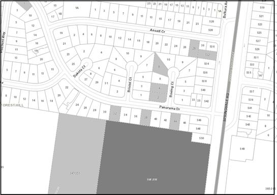
|
|
|
|
Subject site
|
|
10 Objector Properties
|
é
North
|
BACKGROUND
History
Planning permit WH/2004/15070 was
issued 26 October 2005 to erect and display three internally illuminated
business identification signs.
Planning Permit WH/2006/441 was
issued 15 August 2006 for the use and development of a four-storey office
building with a basement car park (three levels of office and 2 levels of
parking) and display of internally illuminated signage.
Planning Permit WH/2019/855 was
issued for the construction of a stair egress and signage to the terrace of the
existing building.
Planning Permit WH/2019/802 was
issued for the installation of two internally illuminated high-wall building
signs.
The site has been the subject of
recent enforcement action, with the land owner partially constructing a fence
around the site perimeter without the necessary planning approvals. This matter
is still subject to prosecution proceedings.
The Site and Surrounds
The subject site is located at
353-383 Burwood Highway and is described as Lot 2 on Plan of Subdivision
407904L.
The subject site is located at the
north-west intersection of Burwood Highway and Springvale Road. It is
rectangular in shape, with a frontage of approximately 200 metres to Burwood
Highway with a frontage of 240 metres to Springvale Road. The site has an
area of approximately 5.6 hectares.
The site is improved by an existing
multi-storey office building (with glazed facades) in the south-west portion of
the land, a sealed car park and a gravel car park in the north-west portion of
the land, and a separate gravel car park in the south-east portion of the
land. The land is bisected by an east-west aligned accessway, connecting
Springvale Road through to the land parcel to the west and then through to
Woodvale Court.
The northern and north-eastern portion of
the site comprises a stand of remnant native vegetation comprising a healthy
mixed eucalypt canopy of Messmate Stringybark, Longleaved Box (Bundy), Mealy
Stringybark, Narrow leaved Peppermint and Red Stringybark. The ground layer in
this area is regularly mowed/slashed though was dominated by native grasses
including Weeping Grass, Wallaby Grass and Knotty Spear-grass. Other larger
native graminoids including Thatch Saw-sedge, Black-anther Flax-lily and Wattle
Mat-rush are present at the base of some of the canopy trees. An
ecological assessment of this vegetation also identified the existence of weed
species along the northern boundary fence, including Gorse, Sweet Pittosporum,
English Ivy, Wandering Tradescantia and Mirror Bush.
The subject site is affected by the
following easements:
· E-2
is a Sewerage Easement in favour of Yarra Valley Water. The easement runs
along the southern boundary of the site.
· E-4
is a Sewerage Easement in favour of Yarra Valley Water. The easement runs
along the northern boundary of the site.
· Instrument
AJ425703 includes a carriageway easement (shown as E-2) on the caveat.
The easement generally runs in an east-west direction through the site, and the
existing internal road follows the line of the easement. The application
doesn’t seek to alter the location or function of the easement, and the
proposed building will utilise the carriage for ongoing access.
A Section 173 Agreement has been
previously entered into with Whitehorse Council and Hewlett Packard (previous
owner). The Agreement is registered on the title as Instrument AC
195407M. At paragraph 3.3.2 of the Agreement covenants that ‘the
owner will construct a new unsignalised intersection from the land on to
Springvale Road, generally in the location indicated in Schedule 1’. This
requirement has been fulfilled and the intersection is currently in
operation. The site is located within the Tally Ho Major Activity
Centre. The Activity Centre is both a regional hub for high tech commerce
and a centre for the local community. The overall density of built form
in the activity area is low. A central zone of commercial buildings (up to 6
storeys in height) set in a parkland environment, is surrounded by a zone of
mainly residential buildings (mostly between 1 and 2 storeys in height).
Within the immediate context, the following is noted:
North
· To
the north, the site is bordered by residential properties that have a frontage
to Panorama Drive (a street running east-west). These properties are generally
occupied by single-storey dwellings, and significant vegetation provides a
buffer at this interface.
East
· To
the east, is Springvale Road, a north-south arterial road. In the
vicinity of the site, Springvale Road operates as a divided carriageway
providing for 3 lanes of through traffic in each direction. On the eastern side
of Springvale Road is a small shopping precinct which includes Burvale Hotel,
Dan Murphy’s and small food and drinks premises.
South
· To
the south, is Burwood Highway, an east-west arterial road, which provides a
connection to Melbourne’s CBD. In the vicinity of the subject site,
Burwood Highway is a divided carriageway providing 3 traffic lanes in each
direction. A dedicated tram fairway is provided in the central median of
Burwood Highway. On the southern side of Burwood Highway is the Tally Ho
Business Park which contains a number of low-scale commercial buildings.
· Recent
eight-storey approval was issued to 380 Burwood Highway (WH/2017/646). The
approval allows for retail spaces including food and drink premises, an
education centre, offices and apartments.
West
· To
the west, is an existing business park, comprising a mix of built forms
including a 1-2 storey medical facility.
Woodvale Court is a private road,
extending north from Burwood Highway, providing access to 347-351 Burwood
Highway and the Peter James Centre. The site’s accessway is a
private road aligned east-west connecting Springvale Road through to Woodvale
Court. The site accessway has a width of approximately 6.5 metres.
The site is well serviced by public
transport with a number of services located within convenient walking distance
of the site. Tram route 75 operates along Burwood Highway, and bus route 7.
Planning Controls
Commercial 1 Zone
Under Clause 34.01-1, the use of
the land for office and retail premises is as-of-right in the zone (no permit
required).
Under Clause 34.01-4 a permit is
required to construct a building or construct or carry out works.
Design and Development Overlay,
Schedule 9 (DDO9)
The subject site and surrounding sites to the east, west and
south are affected by the Design and Development Overlay. The site is
located within Schedule 9 to the Overlay, which relates to the Tally Ho
Activity Centre.
Under
Clause 43.02-2 a permit is required to construct a building or construct or
carry out works.
Specifically for this subject site,
it is designated as being subject to:
· A
preferred building height of 14 metres; and
· A
preferred building setback of 10 metres from all boundaries for building walls
up to 8 metres in height.
Native Vegetation
Under Clause 52.17 a permit is
required to remove, destroy or lop native vegetation, including dead native
vegetation.
Land Adjacent to a Road Zone,
Category 1
Under Clause 52.29, a permit is
required to intensify (alter) the use of the existing vehicle crossovers.
Bicycle Facilities
Under Clause 52.34-1 a new use must
not commence, or the floor area of an existing use must not be increased until
the required bicycle facilities are provided on the land. A permit may be
granted to vary, reduce or waive any requirement of the Clause.
PROPOSAL
The application proposes the construction
of a multi-level office complex, with some ground floor retailing and basement car
parking, in the north-west portion of the site. The building will be
constructed where the existing northern sealed car park and gravel car park are
situated, with a setback of 23.53 metres to the north boundary.
The key features of the proposal
include:
· Built
form
The office complex comprises two
buildings separated by an internal atrium. Each building has dimensions
of 34.2 by 99.4 metres over six levels (above the basement levels).
The building will have an overall
height of 26.6 metres above ground level. Each building has a simple form
framed by glazing with feature solar fin shading panels and flat roof form.
The breakdown of the floor area
includes:
o 34,872 square metres of
office net floor area,
o 734 square metres of
food and drink premises net floor area at ground level,
o 728 square metres of
retail net floor area at ground level, and
o 789 square metres of end
of trip facilities (showers, change facilities etc).
· Car
Parking
o The application provides
a total of 1250 parking spaces which includes 1006 within the basement car
parking (3 levels) and 244 at-grade car parks,
o 24 motorcycle parking
spaces,
o 288 on-site bicycle
parking spaces, and
o Provision of changes
rooms, storerooms and service room within the basement levels.
· Vehicular
Access
Vehicular access is provided to the
site via the existing accessway that runs through the site connecting
Springvale Road and Woodvale Court. The internal road network is proposed to be
re-aligned and the existing curve in the road removed.
· Tree
Removal
Based on the current design response,
the removal of a total of 80 trees, including 30 eucalypt trees above 10 metres
and 21 eucalypt trees less than 10 metres in height will be required. Trees 49
(13m high Eucalyptus obliqua) and 344 (15m high Eucalyptus goniocalyx)
are the only high values trees proposed to be removed as they are located
within the proposed building footprint. Of the rest, 21 low retention value
trees and 39 medium value trees are proposed to be removed as they are also
located within the proposed building footprint. The removal of another 20 low
and medium retention value trees is proposed as they are mostly at the edge of
the basement and ramp.
A Development Impact Report was
submitted with the application and the information contained within this
report, assesses the trees as exhibiting low to medium retention value, and the
proposal will have a low level of construction impact (less than 10%
encroachment into TPZs) on the 72 trees to be retained.
The application is informed by:
· Development
Plans, prepared by Elenberg Fraser, dated Revision H, dated 30 August 2019,
· Arborist
Report, prepared by Axiom Tree Management P/L, dated 18 June 2020,
· Concept
landscape Plan prepared by Tract, dated 30 April 2020,
· Landscape
Plan, prepared by Zenith Concepts, November 2019,
· Sustainable
Management Plan Report, prepared by ADP Consulting Engineering, dated 1
November 2019,
· Waste
Management Plan, prepared by Irwin Consult, dated 31 October 2019, and
· Traffic
Report, prepared by Traffix Group, dated October 2019.
CONSULTATION
Public Notice
The application was advertised by
mail to the adjacent and nearby property owners and occupiers and by erecting
notices to each street frontage. Following the advertising period, 10
objections were received.
The issues raised are summarised as
follows:
Neighbourhood Character
· Excessive
building height and visual bulk
· Inconsistent
with neighbourhood character
· Inadequate
setbacks
· Excessive
building footprint
· Reflective
external surfaces
Environmental Impacts
· Loss
of vegetation and wildlife in the area
· Reduction
of natural screen to residential area
· Against
the character of the area
· Does
not provide enough landscaping, tree replacement, greenery, open spaces etc.
Traffic and Car Parking
· Increased
traffic and congestion
Amenity Impacts
· Impact
on privacy of the residential properties
· Construction
Impacts
· Safety
and crime
Infrastructure
· Limitations
of residential infrastructure resulting from an increased in commercial
traffic.
Consultation Forum
A Consultation Forum was held on
Thursday 27 February 2020. 10 objectors attended the meeting, which was chaired
by (then) Ward Councillor Bill Bennett, and also attended by 3 planning
officers. There were no resolutions reached.
Objectors raised general issues
relating to excessive building height and visual bulk, neighbourhood character,
the inadequacy of setbacks from the northern residential properties, use of
reflective materials, increased traffic congestion in the local area, impact on
privacy and extent of vegetation removal. Despite a robust conversation with
the applicant, no resolution of issues was explored. Subsequently, no consensus
was reached between the parties.
Referrals
External
· Department
of Environment, Land, Water and Planning
The Department of Environment, Land,
Water and Planning supports the extent of native vegetation removal subject to
an offset being secured.
· Department
of Transport
The Department of Transport supports
the proposal subject to conditions.
Internal
Waste Management Officer
The waste management plan was
accepted by Council’s Waste Management Officer subject to standard
conditions and permit notes.
Transport Engineer
The application has been reviewed
by Council’s Transport Engineer. Having assessed the development,
the proposal is supported subject to increased parking provisions and design
modifications.
Assets Engineer
Council’s Assets Team is
supportive of the proposal subject to conditions.
Planning Arborist
The application has been reviewed
by the Council’s Arborist. The Development Impact Report, prepared
by Axiom Tree Management P/L is satisfactory, and a Tree Management Plan is
recommended to be required via conditions of any permit issued.
ParksWide
The application has been reviewed
by Council’s ParksWide Team. They have identified that there are no
street trees affected by the proposal.
Landscape Architect
The application has been reviewed
by Council’s landscape architect. The landscape plan is
satisfactory subject to modifications.
Environmental
Sustainable Development
The application has been reviewed by Council’s
Environmentally Sustainable Development officer. A review of the Sustainability
Management Plan (SMP) Report and Development Plans finds that this application
is yet to meet Council's Environmentally Sustainable Design (ESD) standards for
a development of this size and potential environmental impact.
To address the shortcomings, a number of matters can be
addressed via conditions of any permit issued.
Assets
Engineer
The application has been reviewed
by Council’s Asset Engineer. The application is supported subject
to standard conditions and notes being placed on the permit. In addition to
conditions and notes, the Asset Engineer suggested to seek VicRoad’s
approval for any vehicle crossing or modifications of access to Burwood Highway
and Springvale Road; and to refer the application to the Transport Engineering
Team. As noted above, the referral to VicRoads and Council’s Transport
Engineering Team have been completed.
DISCUSSION
The subject site is located within
the Tally Ho Activity Centre, a higher-order activity centre, although one
which currently primarily serves an employment function with a limited range of
other land uses. Within the Planning Policy framework, including Plan Melbourne
and Local Planning Policies, key themes emerge in relation to the strategic
directions for the Tally Ho Major Activity Centre.
Clause 22.06 identifies activity
centres in the City of Whitehorse, and the important contribution to local
service provision, vibrant local economies what these centres provide
for. It is policy:
· Tally
Ho continues as an activity centre with a focus on creating a high quality
built and natural environment for innovation, knowledge and technology-based
businesses while broadening its range of land uses.
Clause 22.08 applies to land within
the Tally Ho Activity Centre. The policy requires future land use and
development to have regard to the vision and principles of the strategies in
the Tally Ho Major Activity Centre Urban Design Framework 2007. The objectives
of the policy include encouraging economic growth, increasing the mix in
existing and new developments, discouraging the use of private motor vehicles
and enhancing the quality and extent of landscaping.
Accordingly, the proposal responds to
the following themes in the Tally Ho Activity Centre as follows:
· Supporting
urban consolidation and economic diversity by providing opportunities for
further business development and employment within the activity centre,
· Promoting
economic growth and synergies between uses to service commercial and community
needs,
· Delivering
significant new infrastructure and improved use of a site with good access to
infrastructure, services, facilities and public transport, and
· Improving
the quality of the built environment and creating a safe, functional place with
a sense of connection and identity.
As discussed separately in this
report, the redevelopment of this site has strong policy support, at both State
and Local level, as it is considered one of the prime development sites in the
municipality due to its locational advantages and land area. In particular,
Clause 22.08, Design and Development Overlay Schedule 9 and recent strategic
review of current zoning pushes the site to be developed for office and mixed
use development. However, it is acknowledged that the site is inherited with
some significant physical constraints, including the northern residential
abuttals and extent of native vegetation. Therefore the key consideration of
this assessment is to identity if the proposal balances these competing
objectives of the planning scheme and offers net community benefits.
Commercial 1 Zone
The objectives of the Commercial 1
Zone have an emphasis on the creation of vibrant centres for retail, office,
business and community uses. State Government zone reforms in 2013
automatically rezoned the Business 1 and 2 Zones to the Commercial 1 Zone,
broadening the suite of uses that now no longer need a planning permit. This
change has opened up Tally Ho to significant pressure to accommodate uses that
could potentially undermine the policy intent of the centre as an employment
hub.
In July 2019, a review of the Tally
Ho Activity Centre was undertaken by Council to determine whether the current
Commercial 1 Zone is the most appropriate zone, or whether a more suitable
planning tool could be implemented to ensure the vision of the centre is
achieved. The review concluded that there is a strong case for retaining an
employment focus for the area and in fact recommended rezoning the Commercial 1
Zone to Commercial 3 to provide greater emphasis on employment opportunities,
and give Council the ability to consider through a permit process, other
complimentary uses on the site.
The land uses proposed within this
proposal are ‘as-of-right’ in the zone and achieve the purpose of
the current and proposed zone.
The development will contribute to
the Tally Ho Activity Centre area and will increase the availability of quality
office space with associated retail land uses and will support
Whitehorse’s expanding local economy.
The proposed use and development
achieve a high-level of consistency with the purpose of the zone and the
strategic directions for the area.
Design and Development Overlay,
Schedule 9 (DDO9)
The Tally Ho Activity Centre Urban
Design and Landscape Guidelines were introduced as a reference document via
amendment C110 (October 2015). The Guidelines outline the desired built
form and landscape outcomes for new development on sites within the Tally Ho
Activity Centre and are also reflected within DDO9.
The design objectives within DDO9
are summarised as:
· Reinforce
an image of innovation and knowledge through the establishment of contemporary
buildings nestled within a native Australian landscape,
· To
create a high quality built environment, a good sense of place, active street
frontages and interest at the pedestrian level,
· The
creation of a ‘campus-style development’ with a generous landscape
setting,
· Ensure
sensitive design at the Activity Centre’s interface with adjoining
residential zones,
· Retention
and regeneration of existing native vegetation and habitat and new landscaping
that is high quality that enhances new development,
· Incorporation
of best practice ESD principles, and
· Improve
accessibility and safety for all transport modes.
DDO9 sets out requirements for
building heights, built form, site design and configuration, landscape and
streetscape design and precinct requirements.
Tally Ho is recognised as a key
eastern suburb hub for knowledge workers. Knowledge workers are workers
whose main capital is knowledge. Examples include programmers, physicians,
pharmacists, architects, engineers, scientists, design thinkers, public
accountants, lawyers, and academics, and any other white-collar workers, whose
line of work requires one to "think for a living". In order to
strengthen business development, innovation and continued broadening of
employment opportunities, the Tally Ho MAC must continue to maintain and
attract higher-order employment opportunities. The development achieves
the objective of encouraging economic development that facilitates growth
within the Tally Ho Precinct. The development comprises a range of land
uses that are compatible with the zone such as office and retail. These
uses will provide employment opportunities and act as a catalyst in attracting
other business to the Activity Centre.
The creation of a ‘campus-style development’ is
achieved via the following treatments:
· The
built form includes glazing at both the ground and upper levels,
· The
glazing ensures a degree of transparency both into and out of the building as
well as activation and passive surveillance,
· The
façade materiality will not present as a blank wall to the street
(noting the significant setback from the street), and
· The
landscape areas will ensure the activation of the street edges.
The nominated building heights seek
to create a transition in height from the middle of the site to provide a lower
scale around the boundary of the Activity Centre. The building height of
26.6 metres exceeds the preferred building height of 14 metres; however, its
position from the northern boundary creates a respectful transition. In
particular, the 23.5-metre setback from the residential interface is
significantly greater than the preferred 10 metres, and is further setback from
the road reserves. Generous landscaping areas are provided around the building,
and when coupled with the existing trees will reduce any potential visual bulk
resulting from the additional height.
The proposed built form has been
designed to respect the amenity of the neighbouring residential properties to
the north of the site. DDO9 calls for a 10-metre built form setback from the
north boundary. The proposed building provides a setback of 23.5 metres
from the northern boundary. This is an improved outcome that will ensure
the impact of the built form on the residential lots is reduced. This
setback allows the retention of the existing band of vegetation along the
northern boundary to retain a visual buffer and ensures impacts of noise, light
spill and visual bulk are reduced.
The proposal respects the
residential interface by complying with the ResCode building envelope Standard.
Although this Standard doesn’t apply given the site’s commercial zoning,
the ability to meet (and exceed) this standard indicates the amenity of the
neighbouring residential properties is respected, when tested against a
commonly used and understood method for measuring amenity impacts.
Despite exceeding the preferred height
limits outlined within DDO9, the proposal achieves the objectives by providing
a built form outcome within the existing landscape character of the site.
The increased building height is offset by the provision of a generous 23.5
metres setback from the closest boundary interface.
Landscaping and Trees
Key considerations pertaining to
landscaping include contemporary landscape design to reflect the innovative
character of the activity centre, use of indigenous and native vegetation
throughout the centre, a hierarchy of canopy plantings , retention of existing
indigenous and native vegetation where possible, maintain existing significant
exotic species and where possible avoid large screening shrubs to improve
passive surveillance.
Design objectives within the DDO9
include:
· To
ensure that proposed landscaping is high quality, and complements and enhances
existing and new development,
· To
use landscape as a common thread to connect various parts of the Tally Ho
Activity Centre, and
· To
encourage the retention and regeneration of existing native vegetation and
habitat.
A total of 158 trees close to, or
within, the footprint of the proposed development were assessed within the
arborist report, prepared by Axiom, Tree Management P/L, dated June 2020.
A breakdown of the trees include:
o 123 trees are native to
Victoria
o 13 trees are Australian
natives
o 22 tress are exotic
The most common species include Eucalyptus
goniocalyx – Long-leaved Box, Eucalyptus macrorhyncha –
Red Stringybark, Melaleuca armillaris – Giant Honey Myrtle and Eucalyptus
polyanthemos – Red Box.
Of the assessed trees, Trees 22,
49, 67 and 344 have been assigned a ‘high’ retention value,
seventy-five trees have been assigned a ‘medium’ retention value,
and seventy-nine trees have been assigned a ‘low’ retention value.
In order to facilitate the
development, the application seeks removal of sections of existing vegetation.
The following table sets out the tree retention and removal within the
development. The table below (Table 1) also sets out those trees that incur
less than 10% encroachment, greater than 10% encroachment and those trees
nominated for removal.
*the
reference to encroachment is the percentage of the root system encroached upon.
Table
1
|
Tree Impacts
|
Tree Numbers
|
Count
|
|
Retain
<10%
Less
than or equal to 10% encroachment
|
1, 9,
15-21, 24, 30, 32, 33, 55, 56, 58-67, 108, 112, 228, 263, 266, 329-334, 347,
351-373, 375, 380-382, 384 and 387
|
72
|
|
Retain
>10%
Greater
than 10% encroachment
|
6, 7, 22, 23, 376 and 377
|
6
|
|
Remove
|
2-5, 8, 10-14, 31, 34-54, 57,
99-107, 109-111, 145-147, 219-227, 229, 264, 265, 335-346, 348-350, 374, 378,
379, 383, 385 and 386
|
80
|
While the above table shows that trees 6, 7, 22, 23, 376 and
377 will be encroached by the development for more than 10%, the table below identifies
the exact percentage (%) encroachments:
|
Tree number
|
Species
|
Encroachment (%)
|
|
6
|
Eucalyptus goniocalyx
|
11
|
|
7
|
Eucalyptus polyanthemos
|
27
|
|
22
|
Eucalyptus radiata
|
24
|
|
23
|
Eucalyptus obliqua
|
20
|
|
376
|
Acacia melanoxylon
|
13
|
|
377
|
Melaleuca armillaris
|
12
|
Australian Standard - AS 4970-2009
states that an encroachment of more than 10% into the Tree Protection Zone
(TPZ) is a major encroachment and certain conditions should apply. These
conditions generally include, root mapping, design revisions, low impact
construction methods and work supervisions. Council’s consulting Arborist
has inspected the trees that are subject to major encroachment and recommended
that the applicant provide a Tree Management Plan before the commencement of
the development. It is expected that the above conditions will be fulfilled in
the Tree Management Plan to ensure the longevity of the trees to be retained.
Of the existing trees, a total of
81 trees are to be retained and a total of 80 are to be removed as they are
within or adjacent to the proposed building footprint. However, a
significant buffer of trees along the northern boundary will be retained
ensuring the development maintains a landscaped context and screening towards
the sensitive residential interface.
It is recommended that a Tree
Management Plan be addressed via a condition of the permit. The Tree
Management Plan will address matters of construction impact, tree protection
fencing and measures to address successful ongoing retention and viability
post-construction of trees nominated for retention.
New trees are proposed to be
strategically placed around the new development, including 31 trees within the
northern setback area, to assist with screening the new built form. In
addition to the new trees, a total of 1780 shrubs, ground covers and 2,835
grasses will be incorporated into the new landscape setting.
The landscape plan prepared by
TRACT consultants was referred to Council’s Landscape Architect who has
provided the following comments and conditions:
· The
entry forecourt area and the internal open space provides for views through to
the central plaza and beyond (to the northern landscape buffer zone).
· Seating
nooks around the raised planter beds (incorporating soft planting and small
trees) around the entry forecourt.
· In
internal space (central plaza), includes raised planted beds with soft
planting, seating nooks and break out spaces with seating benches, and defined
area for cafes and retail spaces. It is preferable that the raised garden beds
include some small trees to enhance amenity and reduce a wind tunnelling effect
and be reduced in size to cater for tables and seating associated with the
café and food and drink premises. This can be addressed through permit
conditions.
· The
northern interface includes a number of new trees with a 2 metres wide sand
path to meander between the existing trees. This area would benefit from
the increased shrub planting and ground covers within this area to complement
existing and new trees (consistent with that shown within the TRACT concept
plan).
· The
western interface provides for low-level native planting and some medium to
large trees. As per the TRACT concept plan, it is recommended small terrace
areas be provided (with privacy screens). This requirement will form part of
the permit conditions.
· The
eastern interface includes car parking with raised planters to a separate
footpath. It is recommended increased shrub, and ground-level planting
occurs along with the eastern interface. This requirement also will form
part of the permit conditions.
Council Landscape Architect’s
recommendations contained in the above comments will form part of the permit
condition requiring an amended landscape plan.
In addition to the above, the
landscape plan has been assessed based on the requirements specified in the
Tally Ho Urban Design and Landscape Guidelines and considered acceptable on the
following basis:
· The
landscape design reflects the innovative character of the Tally Ho Activity
Centre.
· The
planting schedule comprises a mix of indigenous, native and exotic plants.
· A
hierarchy of canopy planting is maintained.
· Retaining
native vegetation where possible. In particular, the increased setback from the
northern boundary from 10m to 23.5 metres has doubled the retention of native
vegetation located along the northern boundary.
· Minimising
hard surfaces around the buildings.
A condition of the permit will
require a landscape maintenance plan to ensure for ongoing maintenance and
longevity of the new landscaping regime.
Clause 52.17 – Native
vegetation
Given the size of the lot, the
application is subject to the provisions of Clause 52.17 (Native Vegetation),
and a permit is triggered for the removal of native vegetation. The
purpose of the Clause is to ensure there is no net loss to biodiversity as a
result of the removal, destruction or lopping of native vegetation. This is
achieved by applying the following three-step approach in accordance with the Guidelines
for the removal, destruction or lopping of native vegetation (Department of
Environment, Land, Water and Planning, 2017) (the Guidelines).
The three-step approach includes:
1. Avoid the removal, destruction or
lopping of native vegetation.
2. Minimise impacts from the removal,
destruction or lopping of native vegetation that cannot be avoided.
3. Provide an offset to compensate for
the biodiversity impact if a permit is granted to remove, destroy or lop native
vegetation.
The Native Vegetation Assessment,
prepared by Brett Lane & Associates, details the vegetation that is to be
removed and the impacts of the proposed removal. The total area of native
vegetation proposed to be removed totals 0.578 hectares within location
Category 1. This is comprised of:
· 1
patch of native vegetation with a total area of 0.471 hectares containing 3
large trees.
· 1
large scattered tree
· 2
small scattered trees.
The application was referred to the
Department of Environment, Land, Water and Planning (DELWP). DELWP is satisfied
that the applicant has taken adequate steps to avoid and minimise the proposed
native vegetation removal and that the required offsets can be secured.
The Native Vegetation Report supplied with the application adequately describes
the native vegetation to be removed and the offset requirements.
If the development had only
incorporated the minimum setback requirement of 10 metres from the northern
boundary, there would have been a loss of at least another 8 large trees and
resulting in a major encroachment into a number of trees. Refer to image below,
the blue line in the Figure below refers to 10m setback.
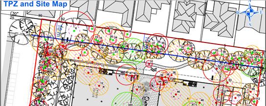
Conversely, as the vegetation on
the site is protected under Clause 52.17, there is no local planning control in
place, such as SLO, to control the removal or to force the applicant to seek
alternative building footprints. Moreover, the Tally Ho Urban Design and
Landscape Guidelines, DDO9, Tally Ho Urban Design Framework etc. have
conceptually encouraged buildings to achieve a minimum 20 metre setback from
the northern residential abuttals.
Balancing Competing Objectives
As discussed
above, the proposal has sought to achieve a reasonable balance between the
various competing provisions and policies that apply to the site. Specifically
the loss of 80 native trees and variation to building height as prescribed in
DDO9 and the site’s economic significance.
In an overall
sense, there is no dispute that the site is located in a viable economic centre
with strong competitive advantages. There was an estimate of 3750 employment
opportunities within the Tally Ho Activity Centre in 2016 with relatively
strong employment growth in the Information and Telecommunications, Scientific
and Technical Services. According to the Tally Ho Major Activity Centre Review,
this area is estimated to accommodate uses which generated $2.4 billion in
economic output and $1.2 billion in value added to the economy. This level of
output equates to approximately 6% of the output across the City of Whitehorse,
signaling that the economic activity occurring in this area is of material
significance to the municipal economy.
The proposed two,
six-storey office buildings comprising 34872 square metres of net floor area
will generate, based on The Building Code of Australia minimum space requirements,
3487 office employees. Therefore the proposed development is significant to
the local community and to achieve the strategic development aim of the Tally
Ho Activity Centre.
According to DDO9,
the required setback from the northern boundary is 10 metres. If the
development incorporated the minimum setback requirement of 10 metres from the
northern boundary, subject to changes to the building height, there would have
been a loss of at least another 8 large trees and resulting in major
encroachment into a number of others. However, according to the current design
response, as shown on the plans, there are 80 trees to be removed, in addition
to the 6 trees that have major encroachments. The Talley Ho Urban Design
Framework and Tally Ho Urban Design and Landscape Guidelines provide the
conceptual outline for the location of future buildings. Therefore there is an
expectation that overall development impacts on vegetation have been previously
considered.
However, as
discussed elsewhere in this report, the permit holder must provide an offset to
compensate for the biodiversity impact in accordance with the conditions
required by DELWP. In addition, the landscape plan proposes 83 canopy trees
including 70 trees with a minimum height of 8 metres to the north and
north-eastern corner of the site. In order to secure the landscape buffer of
those trees along the north boundary that are being retained, a building
exclusion zone is required to be applied through permit conditions.
Although the
building height is increased from the preferred 14 metres to 26.6 metres, the
side setback has increased from 10 metres to 23.5 metres (more than double the
minimum requirement) to ensure that residential amenity of the northern abuttal
is not compromised. The existing and proposed canopy trees between the proposed
building and residential area will reduce the visual bulk and other perceived
visual impacts of the buildings to the occupants of the residential land.
The loss of that
number of trees is not an outcome that would ordinarily be considered
acceptable given the emphasis otherwise placed on tree retention within the
planning scheme. In this context however, the zoning of the land, the strategic
significance of the site as a prime office precinct, and competing planning
scheme objectives for securing employment opportunities, results in the need
for a degree of compromise and pragmatism in contemplating an appropriately
balanced outcome for this site. In this case, generous building setbacks and
opportunities for increased tree planting and other landscape outcomes, coupled
with the native vegetation offsets, achieve an acceptable outcome.
Car Parking
The car parking requirements for
the proposed use and development are outlined under Clause 52.06 of the
Whitehorse Planning Scheme. The subject site falls within the Principal
Public Transport Network (PPTN) Area Map, and therefore the Column B rates
apply under Clause 52.06-5.
The application has been referred
to the Council’s Transport team for assessment. The following is a
summary of the traffic assessment and the resulting requirement for some
modifications (to be addressed via conditions of the permit).
There appears to be a contradiction in the proposed
‘Office’ floor area for the proposed land uses within the Traffix
Group Report. Page 12 of the report states that ‘The plans prepared
by Elenberg Fraser suggest an office floor area of 34,946 square metres’
while page 14 of the Traffix Group report uses a land floor area of 34,872 for
the proposed office use. For the purposes of this assessment, the larger
floor area has been adopted
|
Usage
|
Area
|
Rate
|
Required Car Parking Spaces
|
|
Shop
|
1,462 sqm
|
3.5 spaces per 100 sqm of LFA
|
51
|
|
Office
|
34,946 sqm
|
3 spaces per 100 sqm of NFA
|
1048
|
|
Total Car Parking
Spaces required
|
1,099
|
The proposal involves the removal
of 141 at grade parking spaces; therefore, the proposal requires the provision
of 1,240 parking spaces within the property.
· Adequacy
of Parking Provision
Planning permit condition 16 of
WH/2006/441 for this development site required that:
A minimum of 315 car spaces
must be made available on the subject land for the approved use and development
at all times. In the event that the at grade parking area shown on the endorsed
plans to the north of the office building is removed, appropriate parking
provision must be made elsewhere on the subject land to the satisfaction of the
Responsible Authority.
The application proposes to
provide a total of 1,250 parking spaces on the subject site, which includes
1,006 spaces within the basement car park, 29 spaces at-grade, and the 215
spaces provided in the at-grade car park in the south-eastern corner of the
site.
· Traffic
Generation
Given that the proposal seeks
approval to alter the access ways (intensification of use), the proposal was
referred to the Department of Transport. The Department is supportive of the
development subject to conditions as discussed below.
The proposed development site can
be accessed via an internal access roadway. This roadway provides direct access
to Springvale Road and to Burwood Highway via Woodvale Court (which is a
private road). The intersection of Burwood Highway and Woodvale Court provides
ease of access to Burwood Highway via existing traffic signals.
The application documents propose
changes to the traffic signal phasing at the above intersection. A preliminary
review of the proposed changes was undertaken by the Department of Transport
and was not considered to be acceptable. As such, the proposed changes to the
existing signal phasing are not approved as part of this planning permit
referral response.
In order to consider and assess
what phasing changes best suit the overall network, a post-development review
of the performance of the Burwood Highway / Woodvale Court intersection is
required. This review needs to analyse the development impacts on this
intersection and recommend appropriate changes that need to be made to address
any operational issues that may arise post-development, or through any
subsequent development on the remainder of the site. No phasing changes are
accepted as part of the current application.
· Future
access to Springvale Road
The Department of Transport has
also provided an assessment of the current access arrangements to Springvale
Road. As it stands traffic generated by the development would be able to
turn right (or go straight to the Burvale Hotel) at the Springvale Road access
point. This presents an unacceptable safety outcome for the Department;
therefore, it has been recommended that exiting traffic should be restricted to
left-out only.
Clause 22.08 (DDO9) of the
Whitehorse Planning Scheme requires new use and development to have regard to
the vision and principles of the Tally Ho Major Activity Centre Urban Design
Framework (UDF). In the UDF, a new signalised intersection on Springvale Road
near the north of the site, approximately opposite the northern Burvale Hotel
access, leading to an internal road network, is shown in “Drawing
9”. The UDF notes: “Future development of Region 1 (the subject
site) is expected to generate a significant increase in traffic and a new
signalised access arrangement should be provided at Springvale Road”. The
UDF traffic assessment adds that “signalised intersection should be
earmarked to control future traffic movements generated by future development
… so as to minimise the number of access points and impact on Springvale
Road and provide a coordinated approach” and further that “the
existing unsignalised movements at the current Springvale Road access to the
[subject site] and Burvale Hotel should be reviewed”.
It is particularly noted that the
development layout is not consistent with the access arrangements in the UDF
– an internal access road in the UDF is shown clearly running through the
location of the proposed buildings. Although this is not necessarily a
confirmed layout of the internal road network for the site, consideration of
some appropriate layout needs to be given to safeguard the ability to provide
such a connection in future as development intensifies. A preliminary plan has
been provided by the applicant’s traffic consultant as part of ongoing
discussions with the Department of Transport showing the ability of the site
overall to accommodate a future access arrangement as anticipated by the UDF. Although
this is by no means a final layout necessarily, the Department of Transport
considers it essential that this future access connection is in some way
formally established as part of this permit process so that it is clear to all
parties that as part of the development of future stages, an internal access
connection is accepted as a requirement.
The Department of Transport is
supportive of the proposal subject to conditions.
· Bicycle
Facilities
The following details the number of bicycle parking spaces required
under Clause 52.34 of the planning scheme:
|
Use
|
Size
|
Statutory
Requirement
|
Number of Bicycle
Parking Spaces Required
|
|
Office
|
34,946 sqm
|
1 to each 300 square metres of leasable floor area to
staff
1 to each 1,000 square metres of leasable floor area to
visitors
|
116 staff spaces
35 visitor spaces
|
|
Retail
|
1,462 sqm
|
1 to each 300 square metres of NFA if the NFA exceeds
1,000 square metres to staff
1 to each 500 square metre of NFA if the NFA exceeds 1,000
square metres to visitors
|
5 staff
3 staff
|
|
Total Bicycle Parking Spaces required
|
121 staff spaces
38 visitor spaces
|
The development provides for 288 bicycle spaces which
exceeds the statutory requirement by 129 spaces. The spaces
are to conform to the requirements of the planning scheme and the Australian
Standards. This alteration will be addressed via a condition of any
permit issued.
Showers and Change Rooms
|
User
|
Bicycle Spaces (staff/resident)
|
Employee/Resident
|
Visitor
|
Number Required
|
|
Shower
|
9
|
1 shower per first 5 spaces 1 per 10 spaces thereafter
|
None
|
2
|
|
Change Rooms
|
9
|
1 per shower or to a communal change room
|
None
|
1
|
The proposed shower and change room
facilities are provided within basement level 1 (adjacent to the bike
storeroom).
Subject to conditions, the
provision of bicycle facilities are in accordance with clause ‘52.34
Bicycle Facilities’ of the Whitehorse Planning Scheme.
Parking Management Plan
A parking management plan needs to
be submitted which will include the allocation of parking spaces to
individual tenancies, signing of parking spaces, line marking of parking spaces
and detail on how access will be achieved by visitors, i.e. an intercom and how
parking will be secured. This can be addressed via conditions of permit.
Clause 22.10 –
Environmentally Sustainable Development
Clause 22.10 applies throughout the
City of Whitehorse to residential and non-residential development that requires
a planning permit in accordance with the thresholds in Table 1 of the policy.
The overarching objective is that
development should achieve best practice in environmentally sustainable
development from the design stage through to construction and operation.
The Sustainability Management Plan Report (SMP Report), dated 1 November 2019,
has been assessed by Council’s ESD officer. The plan is yet to meet
the Council’s ESD Standards, therefore, amended plans and an amended SMP
Report will be addressed via conditions of the permit.
Waste Management
To ensure that the proposed
development will have sufficient capacity and capability to manage the waste
generated by future occupants, a Waste Management Plan has been
submitted. The plan confirms the following:
· The
application proposed all waste to be collected by a private contractor,
· Waste
shall be sorted on-site by cleaners and/or tenants as appropriate,
· Waste
will be stored in a specially designated waste storage room located on the
ground floor. Collections will occur on-site directly from the loading access
areas provided adjacent to each waste room at ground level, and
· At a
minimum, ventilation will be provided in accordance with Australian Standard
AS1668.
The approved Waste Management Plan
will be implemented via conditions of the permit.
Objectors Concerns
Neighbourhood Character
Concerns were raised with the
proposals response to the established neighbourhood character, excessive
building height and visual bulk and inadequate setbacks.
The preferred maximum height limit
of 14 metres is a discretionary limit, yet there needs to be exceptional
circumstances which warrant a departure from the preferred maximum
height. DDO9 especially anticipates development exceeding the
discretionary height limits by setting up a mechanism to assess such
applications. An application to exceed the preferred maximum building
height must demonstrate how the development will continue to achieve the Design
Objectives and Built Form Outcome of the Schedule and other local policy
requirements.
As discussed above, the siting of
the development (more than twice the recommended minimum distance to its
boundary) will ensure the new built form does not unreasonably impose itself to
the northern interface. This is also achieved by the retention of
existing native vegetation and further planting within this setback.
The DDO9 specifically seeks to
achieve a character for the Activity Centre that is defined by contemporary
architecture. The provisions also seek buildings to heighten the sense of
address and demarcation to the activity centre. The new office buildings
will have a visible and sheer profile; however, they are contemporary in design
and contribute towards the distinction of the activity centre.
The character of the activity
centre is evolving with built forms that are higher than the preferred heights
outlined in DDO9. Examples include:
- A
six-storey building (with a preferred 10-metre height limit) at 315-319 Burwood
Highway;
- An
eight-storey mixed-use development at 380 Burwood Highway; and
- A
range of building heights approved of up to 6 storeys through the Development
Plan at 104-168 Hawthorn Road (former Channel 10 site).
Given this context and the range of
height found in approved nearby developments, the proposed building height will
not be an unreasonable outcome within the Activity Centre.
The proposed development on the
subject site will provide a range of increased employment opportunities,
through the additional retail floor space and the substantial amount of
proposed office floor space. The extent to which the proposed development
will provide for these employment opportunities in a highly accessible locality
where residents would currently outnumber available jobs is another important
factor that supports the height and scale of the proposed development.
Traffic and Car Parking
As discussed above, subject to
conditions, the proposal provides a satisfactory provision of car parking.
Amenity Impacts
The proposed development has been
carefully designed to ensure that the potential for inappropriate overlooking
between the proposed building and existing residential properties to the north
is avoided. This has been achieved through the generous 23.5-metre
building setback from the northern boundary and the sensitive interface.
In addition to the generous setback, the existing band of significant
vegetation is to be retained which will provide a visual barrier to the north,
which will also significantly reduce any potential overlooking.
Construction Impacts
A condition of permit can address
the requirement for a Construction Management Plan. The plan will address
the potential impacts of demolition and construction.
Safety and crime
The provision of an office building
and associated uses within appropriately zoned land will not increase crime
within this area. The provision of buildings within the site will provide
activation where there currently is little, and increase the passive surveillance
offered through the uses proposed.
Infrastructure
The application has been reviewed
by the Council’s Assets Team. The proposal is not considered to
unreasonably impact on any of the existing infrastructures within the area.
CONCLUSION
The redevelopment
of this site enjoys strong policy support, at both State and Local level, and
is considered a prime redevelopment site, due to its size and location.
However, it is acknowledged that the site is not void of constraints, in
particular the existing native vegetation present along the northern and
southern boundaries. Subsequently, one of the key assessment criteria of
the proposal lies in the balancing of maintaining existing vegetation on site
and enabling for the appropriate scale of built form on the land. Overall,
officers consider that the extent of tree removal onsite is reasonable, as the
proposal provides a significant setback (20 metres) from the northern boundary,
which has enabled the retention of up to 50% of the trees located within the
proximity of the development. Furthermore, the Council’s strategic
direction provides for the retention of trees elsewhere in the municipality to
balance the intensive development of Major Activity Centres.
The proposal for
the use and development of the land for two office buildings, including
vegetation removal and alteration of access to a Road Zone is an acceptable
response that satisfies the relevant provisions contained within the Whitehorse
Planning Scheme, including the State and Local Planning Policies, the
Commercial Zone and the objectives and decision guidelines of the Design and
Development Overlay, Schedule 9.
A total of 10 objections were received as a
result of the public notice, and all of the issues raised have been discussed
as required.
It is considered that the application
should be approved, subject to conditional changes, as discussed in this
report.
Attachment
1 Architectural
Plans 
2 Landscape Plan
Council Meeting 27
January 2021
9.1.3 25-35
Prospect Street, Box Hill (CM SP 27315V, Lots 62 to 64 LP 6554) Use of the land
for accommodation (dwellings), buildings and works for a 23 storey mixed use
development, 6 levels basement and reduction to the car parking requirements.
FILE NUMBER:
WH/2019/1332
ATTACHMENT
SUMMARY
This application was advertised
and 1 objection was received, in addition to a submission from VicTrack. The
objection raised issues concerning the advertising process, tree removal,
access, traffic & parking, wind impacts, overshadowing, noise, reflective
external surfaces, limited landscaping, limited open space, pedestrian safety,
absence of shared footpaths or bicycle lanes, not aligned to Box Hill Vision,
no common laundry, traffic and noise impacts of construction period.
This report assesses the
application against the relevant provisions of the Whitehorse Planning Scheme,
as well as objector concerns. It is recommended that the application be
supported, subject to conditions.
RECOMMENDATION
That Council:
A. Being the Responsible Authority, having caused
Application WH/2019/1332 for 25-35 Prospect Street, BOX HILL (CM SP 27315V,
Lots 62 to 64 LP 6554) to be advertised and having received and noted the
objections is of the opinion that the granting of a Planning Permit for the Use
of the land for accommodation (dwellings), buildings and works for a 23 storey
mixed use development, 6 levels basement and reduction to the car parking
requirements, is acceptable and should not unreasonably impact the amenity of
adjacent properties.
B. Issue a Notice of Decision to Grant a Permit
under the Whitehorse Planning Scheme to the land described as 25-35 Prospect
Street, BOX HILL (CM SP 27315V, Lots 62 to 64 LP 6554) for the Use of the land
for accommodation (dwellings), buildings and works for a 23 storey mixed use
development, 6 levels basement and reduction to the car parking requirements,
subject to the following conditions:
1. Before the development starts, but
excluding the works detailed in the Early Works Plan, amended plans must be
submitted to and approved by the Responsible Authority in a digital format.
Once approved, the plans will be endorsed and will then form part of the
permit. The plans must be drawn to scale, with dimensions, and be generally in
accordance with the plans prepared by Peddle Thorp Architects, revision 5,
dated November 2020, but modified to show:
a) At least 250m² of communal open space
(COS) accessible to all dwellings.
b) In accordance with the recommendations of the
Wind Report referred to in Condition 14 of this permit, the entrance of the
‘lower ground floor shop’:
i. Recessed in from the front boundary by
500mm.
ii. Provided with additional vertical columns
generally in accordance with Figure 17 of the Wind Report.
c) No part of any building (includes fixtures and
excludes street level roof canopy awnings) must encroach over any property boundaries.
d) All front podium façade windows recessed
by at least 1 metre.
e) A new western pedestrian access point for the
end-of-trip facility via the external splayed wall of the ground floor rebate
area, adjacent to the ‘unsecured bike spaces’ as detailed on the
plans.
f) The roof canopy extending into the road
reserve, must be a minimum height of 3 metres above ground level, and must be
setback no closer than 750mm to the back-of-kerb of any road.
g) The entrance of the ‘lower ground floor
shop’ relocated at least 2 metres further east from the proposed
crossover.
h) All doors that open out onto the footpath (gas
meter and booster) are able to open 180 degree flat against the building wall.
i) A detailed schedule and samples of all
external cladding materials, colours and finishes, including fine grain details
of façade treatments such as door and window openings at all levels but
particularly:
i. At the ground and first floor levels
which interface with Prospect Street. Consideration must be given to
energy efficiency properties, durability and maintenance requirements of
selected colours and finishes;
ii. Appropriate external materiality to ensure
that any site services visible to the street will blend within the urban design
of the front façade of the podium;
iii. A coloured schedule of the materials, colours and
finishes to be used on the main external surfaces, including roofs, walls,
windows, doors of the proposed buildings. Issues relating to glare and
reflectivity of chosen building materials must be addressed within a
reflectivity assessment report prepared by a suitably qualified professional to
ensure that external building materials and finishes will not result in
hazardous or uncomfortable glare to pedestrians, public transport operators and
commuters, motorists, aircrafts, or occupants of surrounding buildings and
public space to the satisfaction of the responsible authority
iv. The side podium walls to be constructed of patterned
concrete;
v. The stone cladding finish for the upper floor
levels of the podium, extended down to street level (at least 30% of all ground
level vertical columns apply);
vi. Specific pattern and/or textured finishes for
external balconies and walls including soffits.
j) All dwelling private open space areas to
comply with Clause 58.
k) The 3 dwellings (2x two bedroom, and 1x one
bedroom dwellings) in the south-eastern corner of the respective floor plate
for floor levels 4-15, to have front entries no further away than 1.5 metres
from the south-east orientated main corridor. Any required floor layout
modifications resulting from this requirement, must still allow each dwelling
to comply with all provisions of Clause 58.
l) The door and associated internal wall to
the study of dwelling types 15 and 19 across all floor levels of the
development hereby approved, deleted.
m) A convex mirror located in the south-western corner
of the Residential Lobby corridor to the rear of the lift core, to enhance
sight lines within this lobby area.
n) All columns that abut car parking spaces must
be located and dimensioned so that they are not within the area shown in
‘Diagram 1’ of Clause 52.06-8 to improve access to a parked
vehicle.
o) A pedestrian sight triangle for the accessway
and the western boundary wall in accordance with Clause 52.06-08;
p) Ramp grades to be nominated on the main section
of each ramp between basement levels 1 to 6.
q) A longitudinal section of the circulation
roadway showing the headroom provided at the entry point and along the travel
path of the proposed 6.4 metre long waste collection vehicle demonstrating a
minimum vertical headroom of 3.5 metres;
r) The location of Council’s
stormwater pit in the Road Reserve that does not conflict with the proposed
vehicle crossing.
s) All necessary exhaust fans detailed in
locations that appropriately mitigate against external amenity impacts on noise
generation;
t) The locations of Tree Protection Zone
described in Condition 6, with the nominated street trees clearly notated on
both site and landscape plans, and a summary of the requirements of Conditions
6 and 7 to be annotated on the development and landscape plans.
u) Any changes required to reflect Conditions 4
(landscape plan), 11 (CPMP), 13 (SMP), and 16 (WMP) of this permit;
v) The landscape plan (Condition 4) and landscape
maintenance plan (Condition 5), SMP (Condition 13), Wind Report (Condition 14),
and WMP (Condition 16) form part of the Condition 1 endorsement.
All of the
above must be to the satisfaction of the Responsible Authority. Once approved
these plans become the endorsed plans of this permit.
2. The layout and operation of the site and the
size, design and location of the buildings and works permitted must always
accord with the endorsed plans and documents, and must not be altered or modified
without the further written consent of the Responsible Authority.
3. The use of the land for accommodation as
approved, must not commence until all of the buildings and works and
landscaping hereby approved are completed to the satisfaction of the Responsible
Authority.
Landscaping / Tree Protection
4. Prior to commencement of any approved buildings
and works, but excluding the works detailed in the Early Works Plan, a detailed
landscape plan prepared by a suitably qualified and experienced person or firm
has been submitted to and endorsed by the Responsible Authority. Once
endorsed this plan shall form part of this permit. This plan must show:
a) Planting throughout the development including
front façade treatment, balconies, terraces and various gardens,
detailing:
i. A complete garden scheme;
ii. Capacity for the planting to achieve visual
softening of building bulk;
iii. The proposed garden beds and the green walls /
facade (footprint and depth);
iv. A planting schedule of all proposed vegetation
(trees, shrubs and ground covers) which includes, botanical names, common
names, pot size, mature size and total quantities of each plant, and is
‘fit for purpose’ for the respective plants proposed location;
v. Soil depths for all planted species;
iv. Details of all suitable containerised planting
infrastructure and tree anchoring systems;
iv. All proposed services nominated.
Landscaping in accordance with
this approved plan and schedules must be completed before the development is
occupied. Once approved these plans become the endorsed plans of this permit.
5. Prior to the commencement of the development,
but excluding the works detailed in the Early Works Plan, a Landscaping
Maintenance Plan must be prepared by a suitably qualified consultant must be
submitted for approval to the satisfaction of the Responsible Authority. The
landscaping maintenance plan must include, but is not limited to:
a) Details of the ongoing maintenance procedures
to ensure that the garden areas and all plants remain healthy and well
maintained to the satisfaction of the Responsible Authority. This must include:
i. Irrigation frequency and delivery method.
ii. Drainage.
iii. Pruning and mulching.
iv. Specific procedural measures confirming how all
vertical/hanging/cascading plants will be maintained;
v. Any dead or dying plant species detailed in the landscape
plan detailed in Condition 4 of this permit to be replaced with similar plant
species as necessary to the satisfaction of the Responsible Authority.
Once approved this plan will
become part of the endorsed plans of this permit.
6. Prior to commencement of any building or works
(includes demolition and early works) on the land, a Tree Protection Zone (TPZ)
must be established on the naturestrip and maintained during, and until
completion of, all buildings and works including landscaping, around the
following trees in accordance with the distances and measures specified below,
to the satisfaction of the Responsible Authority:
a. Tree Protection Zone distances:
i. Tree 1 (Platanus x acerifolia, London
plane tree) – 3 metres from centre base of tree.
ii. Tree 2 (Platanus x acerifolia, London plane
tree) – 2.4 metres from centre base of tree.
iii. Tree 3 (Platanus x acerifolia, London plane tree)
– 4.4 metres from centre base of tree.
b. Tree Protection Zone measures are to be
established in accordance with Australian Standard 4970-2009 and are to include
the following:
i. Erection of solid chain mesh or similar
type fencing at a minimum height of 1.8 metres in height held in place with
concrete feet.
ii. Signage placed around the outer edge of
perimeter the fencing identifying the area as a TPZ. The signage should be
visible from within the development, with the lettering complying with AS 1319.
iii. Mulch across the surface of the TPZ to a depth of
100mm and undertake supplementary provide watering/irrigation within the TPZ,
prior and during any works performed.
ii. No excavation, constructions works or
activities, grade changes, surface treatments or storage of materials of any
kind are permitted within the TPZ unless otherwise approved within this permit
or further approved in writing by the Responsible Authority.
iii. All supports and bracing should be outside the TPZ
and any excavation for supports or bracing should avoid damaging roots where
possible.
iv. No trenching is allowed within the TPZ for the
installation of utility services unless tree sensitive installation methods
such as boring have been approved by the Responsible Authority.
v. Where construction is approved within the TPZ,
fencing and mulching should be placed at the outer point of the construction
area.
vi. Where there are approved works within the TPZ, it
may only be reduced to the required amount by an authorized person only during
approved construction within the TPZ, and must be restored in accordance with
the above requirements at all other times.
7. During construction of any buildings, or during
other works, the following tree protection requirements are to be adhered to,
to the satisfaction of the Responsible Authority:
a) All buildings and works for the demolition of
the site and construction of the development (as shown on the endorsed plans)
must not alter the existing ground level or the topography of the land within
2.5 metres of any street tree.
b) No roots are to be cut or damaged during any
part of the construction process.
c) Any underground services within the tree
protection zone must be bored.
d) Any excavation within the tree protection zone
of the street tree must be undertaken by hand, hydro excavation or air spading
to ensure adequate protection of the trees root network.
8. The garden and recreational areas at Levels 4
and 18, must be available for use by all residents and employees.
9. The garden areas shown on the endorsed plan
must only be used as gardens and must be maintained in a proper, tidy and
healthy condition to the satisfaction of the Responsible Authority.
Façade (Access and Strategy)
10. Before the development starts, but excluding the
works detailed in the Early Works Plan, a Façade Strategy must be
submitted to and be to the satisfaction of the Responsible Authority. When
approved this will form part of the endorsed plans. All materials, finishes and
colours must be in conformity with the approved Façade Strategy to the
satisfaction of the Responsible Authority. The Facade Strategy must detail:
a) Consistency with the Condition 1 requirements.
b) A concise description by the architect of the
building design concept and how the façade works to achieve this.
c) A schedule of colours, materials and finishes,
including the colour, type and quality of materials showing their application
and appearance. This can be demonstrated in coloured elevations or renders from
key viewpoints, to show the materials and finishes linking them to a physical
sample board with clear coding.
d) External building materials and finishes not
resulting in hazardous or uncomfortable glare to pedestrians, public transport
operators and commuters, motorists, aircraft, or occupants of surrounding
buildings and public spaces;
e) Elevation details generally at a scale of 1:50
illustrating typical podium details, entries and doors, typical privacy
screening and utilities, typical tower detail, and any special features which
are important to the building’s presentation.
f) Cross sections or other method of
demonstrating the façade systems, including fixing details indicating
junctions between materials and significant changes in form and/or material.
g) Roof canopies with screens to prevent rain
water from dripping onto pedestrians, patrons and visitors alike;
h) Information
about how the façade will be accessed and maintained and cleaned,
including planting where proposed.
i) Example prototypes and/or precedents that
demonstrate the intended design outcome indicated through plans and perspective
images to produce a high quality built form outcome in accordance with the
design concept.
Car Parking Management Plan (CPMP)
11. Before the development commences, but excluding the
works detailed in the Early Works Plan, a CPMP to the satisfaction of the
Responsible Authority must be submitted to and approved by the Responsible
Authority. When approved, the CPMP will be endorsed and will form part of
this permit. The CPMP must address, but not be limited to, the following:
a) The number, dimensions, and allocation
(including number and location) of car parking spaces for all land uses hereby
approved and visitors including the 42 unallocated car spaces allocated as
follows:
i. Office (18 additional spaces allocated,
161 spaces in total);
ii. Retail (24 additional spaces allocated, 45
spaces in total);
b) The management of any applicable visitor car
parking spaces and security arrangements (intercom etc) for occupants of the
development, including details on how residential visitors are to access car
parking;
c) Car share arrangements;
d) Management of loading bays for all retail land
uses, including all vehicular and pedestrian related activity, and any
potential traffic conflict caused by queuing instances from the mentioned
purposes;
e) Details of way-finding, cleaning and security
of the end of trip bicycle facilities;
f) The provision and allocation of usable
and secure storage space in accordance with Clause 58.05-4. All storage space
must not be constructed of any visibly transparent materials, and be provided
with heavy duty locks given their public accessible location;
g) Detail any access controls to the parking area,
such as boom gates which must take into account the required queue length
required as per section 3.4 of AS 2890.1.
h) A schedule of all proposed signage including:
i. Directional arrows and signage,
informative signs indicating location of disabled bays and bicycle parking;
ii. Exits;
iii. Restrictions;
iv. Pay parking system; and
v. Any other relevant signs;
vi. The collection of waste and garbage including the
separate collection of organic waste and recyclables, which must be in
accordance with the Waste Management Plan required by Condition 16 and
vii. Details regarding the management of loading and unloading
of goods and materials.
12. The provisions, recommendations and requirements of
the endorsed Car Park Management Plan must be implemented and complied with to
the satisfaction of the Responsible Authority.
Sustainability Management Plan (SMP)
13. Prior to commencement, but excluding the works
detailed in the Early Works Plan, an amended SMP to the satisfaction of the
Responsible Authority must be submitted to and approved by the Responsible
Authority. Once approved, the amended SMP will be endorsed and will form
part of this permit. The amended SMP must be generally in accordance with the
SMP prepared by JBA Consulting Engineers Pty Ltd, dated 18/12/2019, but
modified to include, show or address:
a) Consistency with the requirements of Condition
1.
b) A complete, ‘Published’ BESS
Report, with an acceptable overall score that exceeds 50% and exceed the
‘pass’ marks in the categories of Water, Energy Stormwater and
Indoor Environment Quality (IEQ) or that is otherwise to the satisfaction of
the Responsible Authority.
c) An Integrated Water Management Assessment
addressing stormwater quality performance in addition to ensuring that the
Responsible Authority’s collective integrated water management
expectations and requirements pursuant to Clauses 34 and 44 of the State
Environment Protection Policy (Waters) are satisfied.
d) Appropriate access indicated to maintain and
service integrated water management systems demonstrated on Development Plans.
e) An annotation on Development Plans indicating
the capacity of the rainwater tanks and that the capacities stated are
allocated exclusively for reuse/retention purposes and excludes any volume
allocated for detention.
f) The amount of toilet services and
irrigation areas that the rainwater tanks will facilitate annotated on
Development Plans.
g) Water efficient fixtures and fittings include
minimum 5 star WELS taps, 4 star WELS toilet, 3 star WELS showerheads (≤
7.5 L/min) and 4 star WELS urinals.
h) Daylight modelling assessments for residential
and non-residential areas to the satisfaction of the Responsible Authority.
i) Natural ventilation with all operable
windows, doors, terrace openings and vents provided in elevation drawings.
j) Preliminary NatHERS Energy Efficiency
Assessments for 10% of the total amount of dwellings within the
development. The assessment, as a whole, must ensure that thermally
unique dwellings have been modelled, representative of an equitable, average,
performance of the development. Each dwelling must demonstrate that the
development will achieve cooling loads ≤ 21 MJ/m2/annum.
Assessments must demonstrate an average NatHERS energy efficiency star rating
of 6.5 achieved throughout the development with no dwelling performing below
5.5 stars. Indicative commitments towards thermal performance (i.e.
R-values), artificial lighting and glazing (i.e. U- and SHGC- values) for
residential areas must be provided.
k) A Preliminary BCA Section J or JV3 Energy
Efficiency Assessment for non-residential areas indicating a 10% improvement in
energy efficiency performance with respect to the development’s
reference/base case. The assessment is required to include indicative
commitments towards thermal performance (i.e. R-values), artificial lighting
and glazing (i.e. U- and SHGC- values) for non-residential areas undertaken in
accordance with, as a minimum, the National Construction Code 2016 Building
Code of Australia standards.
l) Energy efficient heating, cooling and hot
water systems indicating the associated COP and EER values or energy efficiency
star ratings.
m) A minimum 30 kW solar photovoltaic system.
n) Exterior building services equipment including
any heating, cooling, ventilation, hot water and renewable energy systems on
Development Plans.
o) Double glazing for all external windows.
p) Car park ventilation fitted with CO sensors.
q) Car park lighting, where reasonably safe to do
so, fitted with motion sensors or timers.
r) All common, external, service and lift
area lighting fitted with sensors or timers.
s) Common, service and lift area ventilation
fitted with sensors or timers.
t) Shadows detailed for all elevations of
the building demonstrating appropriate exterior shading of windows to assist
with mitigating peak energy demand. .
u) The location of alternative transport
facilities including residential, employee and visitor secure bicycle spaces,
electric vehicle infrastructure, showers, and changing facilities demonstrated
on Development Plans.
v) A commitment to divert at least 80% of
construction and demolition waste from landfill.
w) Timber species intended for use as decking or outdoor
timber are not unsustainably harvested imported timbers (such as Merbau, Oregon,
Western Red Cedar, Meranti, Luan, Teak etc.) and meet either Forest Stewardship
Council or Australian Forestry Standard criteria with a commitment provided as
an annotation on Development Plans.
x) Where measures cannot be visually shown,
include a notes table or ‘ESD Schedule’ on Development Plans
providing details of the requirements (i.e. average energy rating for the
development’s dwellings, % energy efficiency improvement, energy and
water efficiency ratings for heating/cooling, hot water and plumbing fittings
and fixtures etc.).
Once
submitted and approved to the satisfaction of the Responsible Authority, the
SMP will form part of the endorsed plans under this permit.
The
requirements of the SMP must be demonstrated on the plans and elevations submitted
for endorsement, and the requirements of this plan must be implemented by the
building manager, owners and occupiers of the site when constructing and
fitting out the building, and for the duration of the building's operation in
accordance with this permit, to the satisfaction of the Responsible Authority.
Wind Report
14. The Wind Assessment Report prepared by VIPAC and
dated 2nd April 2020 will be endorsed and will form part of this
permit. The requirements and outcomes of the Wind Report must be demonstrated
on the development plans submitted for endorsement in accordance with Condition
1b).
The
requirements of the Wind Report must be implemented by the building manager,
owners and occupiers of the site for the duration of the building’s
operation in accordance with this permit, to the satisfaction of the
Responsible Authority.
15. The recommendations of the wind report must be
implemented such that:
a) There is no cost to the Responsible Authority.
b) There is no reliance on the provision of street
trees for wind mitigation.
c) There is no reliance on the provision of any
buildings and works on public land, except roof canopy awnings at street level,
Waste Management Plan
16. Before the development commences, but excluding the
works detailed in the Early Works Plan, an amended Waste Management Plan to the
satisfaction of the Responsible Authority must be submitted to and approved by
the Responsible Authority. When approved, the amended Waste Management
Plan will be endorsed and will form part of this permit. The amended
Waste Management Plan must be generally in accordance with the Waste Management
Plan prepared by MGA Traffic Pty Ltd, dated 16th April 2020, but
modified to include:
a) By designed to include required transportable
waste compactors.
b) Include lift equipment to suit the
transportable waste compactors as required by Condition 16(a).
c) Appropriate provision of private waste vehicle
access and a 3.5 metre ceiling height clearance to service the transportable
waste compactors as required by Condition 16(a).
The
requirements and outcomes of the amended Waste Management Plan must be
demonstrated on the plans and elevations submitted for endorsement.
Once
submitted to and approved by the Responsible Authority, the Waste Management
Plan must form part of the documents endorsed as part of this planning permit.
The
requirements of the Waste Management Plan must be implemented by the building
manager, owners and occupiers of the site for the duration of the
building’s operation in accordance
Lighting Strategy
17. Prior to the
commencement of the development, but excluding the works detailed in the Early
Works Plan, a Lighting Strategy must be prepared to the satisfaction of the
Responsible Authority. The Lighting Strategy must provide details of
proposed lighting of Prospect Street, and must be prepared in accordance with
the Safer Design Guidelines for Victoria, Department of Sustainability and
Environment, June 2005, to the satisfaction of the Responsible Authority.
This lighting
must be maintained and operated for the life of the building to the
satisfaction of the Responsible Authority.
Green Travel
Plan
18. Before the development commences, but excluding the
works detailed in the Early Works Plan, a Green Travel Plan to the satisfaction
of the Responsible Authority must be submitted to and approved by the
Responsible Authority. When approved, the Green Travel Plan will be endorsed
and will form part of this permit. The Green Travel Plan must include, but not
be limited to the following:
a) Consistency with the Condition 1 requirements
of this permit;
b) Car share arrangements;
c) Information for residents and visitors about
public transport options in the area;
d) Measures to encourage uptake of public
transport to and from the approved development.
Early Works and Construction Management Plans
19. Except with the written consent of the Responsible
Authority, prior to the commencement of any buildings or works, an Early Works
Plan must be prepared to the satisfaction of the Responsible Authority. The
Early Works Plan must include (but not necessarily be limited to) initial
demolition, bulk and detailed excavation. All appropriate approvals must be
obtained and the relevant permits in place, prior to endorsement of the Early
Works Plan.
20. Prior to the
commencement of any site works, including demolition or bulk excavation if
applicable, a detailed Construction Management Plan(s) (CMP), to the
satisfaction of the Responsible Authority must be submitted to and approved by
the Responsible Authority. When approved, the CMP will be endorsed
and will form part of this permit and must be implemented to the satisfaction
of the Responsible Authority. This CMP must be prepared by a suitably qualified person, and be in accordance with the City of Whitehorse Construction Management
Plan Guidelines.
When
approved, the CMP will be endorsed and will form part of this permit and must
be complied with, to the satisfaction of the Responsible Authority, to the
extent that this is in the control of the owner of the land. The owner of the
land is to be responsible for all costs associated with the works to be
undertaken in accordance with the requirements of the approved CMP.
21. The provisions, recommendations and requirements of
both the approved Early Works Plan and CMP and must both be implemented and
complied with to the satisfaction of the Responsible Authority.
Alterations/Reinstatement of Assets
22. Prior to commencement, but excluding the works detailed in the Early Works Plan, details of any required street frontage features and footpath areas
from the building facade to the kerb of Prospect Street. The design and
materials must be consistent with the Box Hill Urban Landscape Design
Guidelines Urban Core Treatment prepared as a Streetscape Plan, to the
satisfaction of the Responsible Authority.
23. Prior to the commencement, but excluding the works detailed in the Early Works Plan, detailed engineering drawings must be prepared to the satisfaction
of the Responsible Authority detailing works within Prospect Street. The
plans must show existing and proposed works including surface and underground
drainage, pavement and footpath details, concrete kerbs and channels and street
lighting.
24. If any works are to be undertaken in the road
reserve related to the project, the applicant is required to obtain the Consent
to Undertake Works in the Road Reserve (Road Opening Permit) for any new,
altered or deleted vehicle crossing, water or drain tapping or other opening
within a road reserve. Please note that this is a separate process to the Asset
Protection Permit.
25. The developer/contractor will be required to submit
a Report regarding any pre-existing damage to Council assets (Dilapidation
Report), prior to the Asset Protection Permit being issued and the Protection
Work Notice is signed off (if required). Please note that this Report will have
to show all of the Council assets adjoining to the property boundary, and will
be based on the approved access routes, pending on the approved Traffic
Management Plan.
26. The permit holder must be responsible to meet all
costs associated with reinstatement or alterations to Council or other Public
Authority assets deemed necessary by such Authorities as a result of the
development. The permit holder shall be responsible to obtain an “Asset
Protection Permit” from Council at least 7 days prior to the commencement
of any works on the land and obtain prior specific written approval for any works
involving the alteration of Council or other Public Authority assets.
27. Prior to the occupation of the development, all
boundary walls must be constructed, cleaned and finished to the satisfaction of
the Responsible Authority.
Asset Protection and Drainage Conditions
28. Prior to the commencement of any works, but excluding the works detailed in the Early Works Plan, the owner of the land must enter into an agreement with and
to the satisfaction of the Council’s Asset Engineering Team, in which the
owner covenants and agrees that:
a) Council will be indemnified against any loss or damage it
may incur as a result of any proposed buildings and works constructed on or
over Council owned land.
b) The owner must pay the reasonable costs of preparation, review,
execution and registration of the Agreement.
29. Detailed plans and computations for stormwater,
on-site detention and connection to the legal point of discharge must be
prepared by a registered consulting engineer (who is listed on the Engineers Australia
National Professional Engineer Register) and submitted for approval by the
Responsible Authority prior to the commencement of any works.
30. The completion of stormwater connection to the
nominated point of discharge and stormwater on-site detention must be approved
to the satisfaction of the Responsible Authority prior to the occupation of the
building.
31. Stormwater that could adversely affect any adjacent
land must not be discharged from the subject site onto the surface of the
adjacent land.
32. The qualified civil engineer when undertaking civil
design must ensure that the landscape plan/s and drainage plan/s are
compatible. The stormwater drainage and on site detention system must be
located outside the tree protection zone (TPZ) of any trees to be retained.
33. The development must be provided with external
lighting capable of illuminating access to each the basement ramp and
pedestrian areas at ground floor. Lighting must be located, directed and
shielded and of limited intensity that no direct light or glare is emitted
outside the site, to the satisfaction of the Responsible Authority.
Building
Services
34. All building plant and equipment on the roofs,
balcony areas, common areas, and public thoroughfares is to be concealed to the
satisfaction of the Responsible Authority. Noise emitting plant equipment such
as air conditioners, must be shielded with acoustic screening to prevent the
transmission of noise having detrimental amenity impacts. The
construction of any additional plant, machinery or other equipment, including
but not limited to all service structures, down pipes, aerials, satellite
dishes, air-conditioners, equipment, ducts, flues, all exhausts including car
parking and communication equipment must include appropriate screening measures
to the satisfaction of the Responsible Authority.
Acoustic
Treatment
35. The
Acoustic and Vibration Assessment prepared by Marshal Day Acoustics, dated 26
March 2020 will be endorsed and will form part
of this permit.
36. Prior to the occupation of the
development, a letter of confirmation from a suitably qualified Acoustic
Consultant must be submitted for approval by the Responsible Authority to
certify that the development has been constructed in accordance with the
updated Acoustics and Vibration Assessment.
37. Noise emissions from the site
must be limited to ensure compliance with the requirements of the State
Environmental Protection Policy (Control of Noise from Commerce, Industry and
Trade) No. N-1.
38. The amenity of the area must
not be detrimentally affected by the use of development, including through:
a) The transport of
materials, goods or commodities to or from land;
b) The appearance of any
buildings, works or materials;
c) The emission of noise,
artificial light, vibration, smell, fumes, smoke, vapour, steam, soot, ash,
dust, waste water, waste products, grit or oil; or
d) The presence of vermin;
To the
satisfaction of the responsible Authority.
General Conditions
39. Existing street trees must not be removed or damaged
except with the written consent of the Responsible Authority.
40. All pipes, fixtures, fittings and vents servicing
any building on the land must be concealed in service ducts or otherwise hidden
from view to the satisfaction of the Responsible Authority.
41. The loading and unloading of goods from vehicles
must only be carried out within the boundaries of the site or a dedicated
loading bay and must not affect the function of Prospect Street.
Department of
Transport and Vic Track Conditions
42. Before the development starts, or such other time
agreed to in writing by the Head, Transport for Victoria, amended plans to the
satisfaction of the Head, Transport for Victoria must be submitted to and
approved by the Responsible Authority. When approved, the plans will be
endorsed and will then form part of the permit. The plans must be drawn to
scale with dimensions and three copies must be provided. The plans must be
generally in accordance with the plans submitted with the application (dated November 2020, Revision 5, prepared by Peddle Thorp) but modified to show:
a) Details of fencing or similar barrier measures
to prevent illegal or unauthorised trespass of people onto railway land.
b) Screens or guards to prevent items from being
thrown or falling onto railway land from any part of the building development.
c) The designs prevent items from being thrown or
falling onto railway land from any part of the building development.
d) The development design does not require people
to access onto railway land, or breach electrical safety requirements, for the
purposes of routine cleaning, replacement, inspection, maintenance and repair
of any part of the building or development.
e) The development does not cause reflected
sunlight, or reflect or refract artificial light, such that it interferes with
train driver visibility or interpretation of rail signals. This must be
accompanied by a statement/report prepared by a suitably qualified engineering
consultant that verifies the materials will not interfere with train driver visibility
or signal recognition.
f) The development avoids use of red, green
or yellow colour schemes that may interfere with driver operations.
g) The development’s landscaping and
planting will not interfere with train driver visibility or interpretation of
rail signals upon completion or in the future.
h) The development’s landscaping and
planting will not facilitate illegal access to railway land over boundary fence
or wall via tree climbing upon completion or in the future.
i) The development’s landscaping and
planting will not cause damage to any rail assets or infrastructure, via root
or branch ingress, upon completion or in the future.
j) That any temporary or permanent ground
anchors, soil nails, reinforced earth straps or other ground stabilising devices,
do not penetrate onto railway land.
k) Any facilities intended to house and operate
electrically sensitive equipment, such as a magnetic resonance imaging (MRI)
machine and any associated electrical shielding required to facilitate its
operation.
43. Unless otherwise agreed in writing with Head,
Transport for Victoria and VicTrack, windows, doors and balconies must not be
placed on the title boundary with railway land. Such windows, doors and
balconies if permitted, must:
a) Be designed to prevent illegal trespass of
people onto railway land.
b) Be designed to prevent items from being thrown
or falling onto railway land.
c) Not open beyond the railway land title
boundary.
d) Not require people to access onto railway land
for the purposes of cleaning, replacement, inspection and maintenance.
e) Not cause reflected sunlight to interfere with
train driver visibility or interpretation of rail signals.
f) Not reflect or refract artificial light
such that it interferes with train driver visibility or interpretation of rail
signals.
44. Unless otherwise agreed in writing with Head,
Transport for Victoria and VicTrack, any windows, doors and balconies that are
set back from, and generally facing the railway land title boundary must:
a) Be designed to prevent items from being thrown
or falling onto railway land.
b) Not require people to access onto railway land
for the purposes of cleaning, replacement, inspection and maintenance.
c) Not cause reflected sunlight to interfere with
train driver visibility or interpretation of rail signals.
d) Not reflect or refract artificial light such
that it interferes with train driver visibility or interpretation of rail
signals.
45. Prior to the commencement of work on site detailed
construction / engineering plans and structural computations for any
construction abutting railway infrastructure or railway land must be submitted
and approved by VicTrack, the Head, Transport for Victoria and the Rail
Operator (RO). The plans must detail all basement excavation design, retention
works and controls of the site adjacent to the railway corridor having any
impact on railway land. The design plans must ensure compliance with:
a) The relevant Rail Transport
Operator’s engineering standard for minimum structural gauge clearances
and for minimum clearances to all electrical assets and procedures for works
adjacent
b) Energy Safe Victoria (ESV)
requirements for minimum clearances to electrical assets and works adjacent.
c) Australian Standards AS2067,
AS7000 and Electricity Safety (General) Regulations 2019 (Particularly Part 6
– 610 and 615) for clearances to electrical assets. Clearances required
include for safe working, fire life safety design, electromagnetic interference
and earthing, bonding and electrolysis mitigation design.
d) The required rail collision
loadings and collision protection measures for the building supports adjacent
the rail tracks in accordance with AS5100.1;2017 – ‘Bridge Design,
Scope and General Principals’.
e) Earthquake design loadings
for structure designated as a minimum Importance Level 2, by AS1170.4 –
‘Structural Design Actions, Earthquake Actions in Australia’.
46. Before development starts (including demolition and
bulk excavation), all necessary construction control agreements and indemnity
agreements must be prepared and entered into with the Head, Transport for
Victoria to the satisfaction of and at no cost to the Head, Transport for
Victoria and the Rail Operator.
47. Unless otherwise agreed in writing with Head,
Transport for Victoria, prior to demolition and construction commencing on
site, the permit holder must demonstrate to the satisfaction of VicTrack and
the Head, Transport for Victoria that entry onto railway land or air space over
railway land is not required for fire, light, ventilation and maintenance for
all buildings and works on site.
48. Prior to commencement of demolition or construction
works, the Rail Operator must be contacted through the email address
metrositeaccess@metrotrains.com.au to obtain the Rail Operator’s
conditions and safety requirements for works on, over or adjacent to railway
land.
49. Before development starts (including demolition and
bulk excavation), a Traffic Management Plan must be submitted to and approved
by the Head, Transport for Victoria. The Traffic Management Plan must provide
for:
a) How public transport operations, traffic,
walking and cycling movements will be managed during the demolition and
construction; and
b) How any traffic impact to the railway land and
associated infrastructure will be mitigated.
The Traffic
Management Plan must be implemented and complied with to the satisfaction of
the Head, Transport for Victoria.
All costs
associated with the preparation and implementation of the Traffic Management
Plan will be at no cost to the Head, Transport for Victoria.
The endorsed
Traffic Management Plan must not be modified without the prior written consent
of the Head, Transport for Victoria.
50. Before development starts (including demolition and
bulk excavation), separate Demolition and/or Construction Management Plan must
be submitted to and approved by the Head, Transport for Victoria, VicTrack and
the Rail Operator. When approved, the Demolition and Construction Management
Plan will form a part of this permit. The Demolition and Construction Management
Plan must include (but not be limited to) details of:
a) The buildings, works and other measures
necessary to:
i. Protect railway land, track, overhead
power and associated infrastructure;
ii. Prevent and /or minimise disruption to the
operation of the railway;
b) The remediation of any damage to railway land,
track, overhead and underground power and communication assets associated
infrastructure;
c) Details of required access to the railway land
during demolition and construction of the development with appropriate
durations and schedules;
d) Arrangements for:
i. Any hoarding associated with the
construction of the development at the railway boundary or encroaches onto or
overhangs railway land;
ii. Piling excavation, shoring, stabilising, anchoring,
filling, earthworks or construction associated with the development occurring
on or next to the boundary of the railway land;
iii. The deposit or store of waste, fill or other
materials associated with the development on the railway land;
iv Air and dust management;
vi Operating hours;
vii Noise and vibration controls; and
viii The security of the railway land and associated
infrastructure.
All
demolition and construction works must be carried out in accordance with the
approved Demolition and Construction Management Plan unless with the prior
written consent of the Head, Transport for Victoria. The Demolition and
Construction Management Plan must be prepared, implemented and monitored at no
cost to the Head, Transport for Victoria.
The
Demolition and Construction Plan must be consistent with any Construction
Management Plan required by the Responsible Authority.
51. The permit
holder must, at all times, ensure that the common boundary with railway land is
fenced to prohibit unauthorised access to the rail corridor. Any permanent
walls or fences on the common boundary with railway land must be cleaned and
finished using a graffiti proof finish or alternative measures used to prevent
or reduce the potential of graffiti as approved by the Head, Transport for
Victoria.
52. No drainage, effluent, waste soil or other materials
must enter or be directed to railway land or stored or deposited on railway
land.
53. Prior to the occupation of the development all works
outlined on the endorsed plans must be completed to the satisfaction of the
Head, Transport for Victoria & Vic Track and the Rail Operator at the full
cost to the permit holder.
54. Access to railway assets by rail staff for the
purposes of inspection, cleaning, maintenance and repair is to be maintained at
all times. Existing access routes to railway land must not be closed, diverted
or modified without prior agreement with the by the Head, Transport for
Victoria and the relevant Rail Transport Operator(s).
Time Expiry Condition
55. This permit will expire if one of the following
circumstances applies:
a) The development is not commenced within three
(3) years from the date of issue of this permit;
b) The development is not completed within five
(5) years from the date of this permit;
c) The approved use is not commenced within five
(5) years from the date of this permit.
The
Responsible Authority may extend these periods if a request is made in writing
before the permit expires or within six months afterwards for commencement or
within twelve months afterwards for completion.
Notes
General
a) The granting of this permit does not obviate
the necessity for compliance with the requirements of any other authority under
any act, regulation or local law.
Asset
Engineering
b) The design and construction of the storm water
drainage system up to the point of discharge from an allotment is to be
approved by the appointed Building Surveyor. That includes the design and
construction of any required storm water on-site detention system. The
Applicant/Owner is to submit certification of the design of any required
on-site detention system from a registered consulting engineer (who is listed
on the Engineers Australia National Professional Engineer Register or approved
equivalent) to Council as part of the civil plans approval process.
c) The requirement for on- site detention will be
noted on your storm water point of discharge report, or it might be required as
part of the civil plans approval.
d) All proposed changes to the vehicle crossing
are to be constructed in accordance with the submitted details, Whitehorse
Council’s – Vehicle Crossing General Specifications and standard
drawings
e) The Applicant/Owner is to accurately survey and
identify on the design plans all assets in public land that may be impacted by
the proposed development. The assets may include all public authority services
(i.e. gas, water, sewer, electricity, telephone, traffic signals etc.) and the
location of street trees or vegetation. If any changes are proposed to these
assets then the evidence of the approval is to be submitted to Council and all
works are to be funded by the Applicant/Owner. This includes any
modifications to the road reserve, including footpath, nature strip and kerb
and channel.
f) The Applicant/Owner must obtain a
certificate of hydraulic compliance from a suitably qualified civil engineer to
confirm that the on-site detention works have been constructed in accordance
with the approved plans, prior to Statement of Compliance is issued.
g) There is to be no change to the levels of the
public land, including the road reserve or other Council property as a result
of the development, without the prior approval of Council. All requirements for
access for all-abilities (Disability Discrimination Access) are to be resolved
within the site and not in public land.
h) No fire hydrants that are servicing the
property are to be placed in the road reserve, outside the property boundary,
without the approval of the Relevant Authority. If approval obtained, the
property owner is required to enter into a S173 Agreement with Council that
requires the property owner to maintain the fire hydrant”.
i) The property owner/ builder is to obtain
the relevant permits and consents from Council in relation to asset protection,
drainage works in easements and works in the road reserve prior to the
commencement of any works. Any modifications to the road reserve, including
footpath, nature strip and kerb and channel must be in accordance with the Box
Hill Urban Realm Treatment Guidelines (BHURT).
j) As-constructed drawings prepared by a
Licensed Land Surveyor are to be provided to Council after the completion of
civil works prior to Statement of Compliance or occupation.
k) The developer/contractor is required to submit
a Report regarding any pre-existing damage to Council assets (Dilapidation
Report), prior to the Asset Protection Permit being issued and the Protection
Work Notice is signed off (if required). Please note that this Report will have
to show all of the Council assets adjoining to the property boundary, and will
be based on the approved access routes, pending on the approved Traffic
Management Plan.
Transport
Engineering
l) The architect and/or designer must ensure
that vehicle access is to conform to the Australian Standards for Off-Street
Parking (AS/NZS 2890.1:2004)
m) Redundant vehicle crossing(s) must be removed at the
same time as the construction of any vehicle crossings(s), prior to the
completion of development works and where access to a property has been altered
by changes to the property.
Parks Wide
Arborist
n) Authorisation for removal of Tree 3
(Platanus x acerifolia, London plane tree) will be granted after payment of the
Tree Amenity Value of $27,464.00 for the tree to Council’s Parkswide
department (including removal costs+replanting+2 years maintenance on new
replanting).
o) If any damage to Council trees occurs during
the building works, full amenity value of the trees will be charged to the
applicant. If any trees have to be removed as a part of this project, amenity
value of the trees has to be paid in full to the Council Parkswide Department
prior to the commencement of works.
p) If any works are to be undertaken in the road
reserve related to the project, the applicant is required to obtain the Consent
to Undertake Works in the Road Reserve (Road Opening Permit) for any new,
altered or deleted vehicle crossing, water or drain tapping, roof
canopy/verandah or other opening within a road reserve. Please note that this
is a separate process to the Asset Protection Permit.
q) Prior to the commencement of any works,
excluding site excavation, piling and basement slab, the owner of the land must
enter into an agreement with the City of Whitehorse which will indemnify
Council against any loss or damage it may incur as a result of any proposed
buildings and works constructed on or over Council owned land.
C. Has made this decision having particular regard to the
requirements of Sections 58, 59, 60 and 61 of the Planning and Environment Act
1987.
MELWAYS REFERENCE 47 B9
|
Applicant: CBR
Development Group (Prospect) Pty Ltd
Zoning: Commercial
1 Zone
Overlays: Parking
Overlay Schedule 1
Relevant Clauses:
Clause 11 Settlement
Clause 12 Environmental
and Landscape Values
Clause 15 Built
Environment and Heritage
Clause 16 Housing
Clause 17 Economic
Development
Clause 18 Transport
Clause 19 Infrastructure
Clause 21.05 Environment
Clause 21.06 Housing
Clause 22.03 Residential
Development
Clause 22.04 Tree
Conservation
Clause 22.06 Activity
Centres
Clause 22.07 Box
Hill Metropolitan Activity Centre
Clause 22.10 Environmentally
Sustainable Development
Clause 34.01 Commercial
1 Zone (C1Z)
Clause 45.09 Parking
Overlay, Schedule 1 (PO1)
Clause 52.06 Car
Parking
Clause 52.34 Bicycle
Facilities
Clause 65 Decision
Guidelines
Ward: Sparks
|
|
|
|
Subject site
|
|
1 Objector Property
|
é
North
|
BACKGROUND
History
One (1) previous planning permit
application was lodged for the site of 31-35 Prospect Street, Box Hill for
‘Buildings and works for Construction of 25 storey building, including
use of accommodation (194 dwellings), associated retail and office space, with
basement car park, and reduction to the required car parking
requirements’. This application was subsequently withdrawn on 16/12/2019
once the property of 25-29 Prospect Street transferred into the subject site
(now forming as 25-35 Prospect Street).
The proposal has been subject to
pre-application discussions prior to the submission of the subject application.
The Site and Surrounds
The Site
The subject site is formally
identified as Strata Plan SP 27315V, and Lots 62 to 64 of Plan of Subdivision
PS 6554. The site contains no easements, and slopes east to west by 3 metres,
and south to north by up to 1.5 metres, at gradients of up to 7%. The site is
located on the southern side of Prospect Street, approximately 42 metres east
of Young Street and approximately 134 metres west of Nelson Road. The site is
rectangular in shape, has a northern frontage width of 91.44 metres (facing
Prospect Street), a maximum depth of 38.63 metres, and a total area of
2,809m².
The eastern half of the site is currently occupied by a
single storey office building at 25-29 Prospect Street with basement and ground
level car parking and an adjacent vacant lot. The western of the site at 31-35
Prospect Street is currently vacant, but utilised as a public carpark operated
by Ace Parking, with temporary offices at the rear of the site. The site
retains vehicular access to Prospect Street. The combined site is located
within the Box Hill Activity Centre and is zoned Commercial 1 Zone.
The Surrounds
Immediate Surrounds
The subject site is adjoined by Commercial 1 Zone land to
both side aspects, comprising 4 storey office buildings with front vehicular
access provided directly from Prospect Street. No. 19-23 Prospect Street
adjoins the site to the east, while No. 37-41 Prospect Street adjoins the site
to the west. The entire extent of Prospect Street is dominated by a continuous
row of established London Plane canopy trees on each side of the street,
presenting as a key landscape theme and significant feature of this streetscape.
The site is located within a commercially zoned area,
approximately 19km east of the Melbourne CBD and is within the Major
Development Precinct designated by the Box Hill Transit City Activity Centre
Structure Plan 2007. The Box Hill Metropolitan Activity Centre (Box Hill MAC)
provides retail, education, office, civic, medical, community facilities,
entertainment, dining and recreational opportunities for the regional
population, as well as a major hub for local community activities.
The subject site is located within close proximity (315
metres) of the Box Hill Train Station, which is serviced by Belgrave and
Lilydale train services, with the rail corridor adjoining the southern rear of
the site. A major bus interchange is also located at the Box Hill Train
Station, which is serviced by approximately twenty (20) bus routes. The 109
Tram Service to the Melbourne CBD also runs along Whitehorse Road, further to
the north. There are also major bus routes along Elgar Road, 156 metres west of
the site, that link into the Box Hill bus interchange and the suburban area
west of the site.
There are no major public reserves close to the site. The
narrow Whitehorse Road reserve, and the Box Hill Gardens public reserve are
both located approximately 500 metres north-east of the site, but are also
divided by the busy road junction of Whitehorse Road.
The Box Hill MAC is experiencing
significant redevelopment, with the following sites in the vicinity of the
subject land either approved, under construction, or have been completed:
· 813-823
Whitehorse Road (WH/2016/1109) – 16 storey office / residential
development.
· 820-824
Whitehorse Road (WH/2016/68/A) – 29 storey residential development.
· 3-5
Poplar Street & 837 Whitehorse Road (WH/2017/313) – 29 storey residential
development.
· 836
Whitehorse Road (WH/2014/763/F) – 36 storey and 26 storey tower mixed use
building.
· 843
Whitehorse Road (WH/2017/313) – 36 and 37 storey mixed use development.
· 845-851
Whitehorse Road (WH/2014/1223/A) – 37, 30 and 18 storey residential
development.
· 9-11
Prospect Street (WH/2015/108/A) – 25 storey residential building.
· 34-36
Prospect Street (WH/2016/1156/A) – 30 storey mixed use building.
· 26-28
Prospect Street (WH/2020/9) – 30 storey mixed use building –.
The following applications are
under consideration in proximity to the site:
· 13-17
Prospect Street (WH/2020/83) – 22 storey mixed use building.
· 22-24
Prospect Street (WH/2020/1008) – 30 storey office building.
Planning Controls
Clause 34.01-4 -- Commercial
1 Zone (C1Z)
In accordance with Clause 34.01-1
Commercial 1 Zone of the Whitehorse Planning Scheme, a Planning Permit is
required to use the land for accommodation (dwellings) where the ground floor
frontage width exceeds 2 metres.
In accordance with Clause 34.01-4
Commercial 1 Zone of the Whitehorse Planning Scheme, a Planning Permit is
required to construct and/or carry out buildings and works.
It is noted that commercial uses
(shop, retail and offices) do not require a permit as they are ‘as of
right’ in the zone.
Clauses 45.09-3 (Parking
Overlay) and 52.06-3 (Car Parking)
In accordance with Clauses 45.09-3
and 52.06-3 Parking Overlay, a Planning Permit is required for a reduction to
the required parking requirements for the residential (dwelling) visitors, retail
and office land uses.
PROPOSAL
The proposal comprises ‘use
of the land for accommodation, buildings and works for a 23 storey mixed use
development, 6 levels basement and reduction to the car parking
requirements’. The key features of the proposal include:
· Lower
ground floor level that includes a shop tenancy, main front entries for the
lower ground shop, the upper floor/mezzanine office, the commercial lobby
(access to the balance of the podium office floor levels), residential lobby
(all tower level dwellings) and the end of trip (EOT) facilities which are not
visible to the street, and provided with internal access only.
· Upper
floor ground level includes the upper ground floor/mezzanine office, 2x food
and drink tenancies, site services and street access to the end of trip
facilities.
· The
office floor space is provided over 4 levels (upper ground, first, second and
third floor levels all within the podium). The total office floor area
comprises an area of 8,055m².
· The
retail aspects (lower ground shop and 2x upper ground food and drink premises)
will total 1,687m² in area.
· 262
dwellings, located at levels 4 to 22, all within the tower element of the
building. There will be a mix of 70 X one bedroom, 165 X two bedroom, 24 X
three bedroom, and 3 X four bedroom apartments.
· Vehicular
access will be provided adjacent to the west boundary connecting the six level
basement to Prospect Street at the front of the site. The basement level
carpark will provide a total of 408 car spaces, 236 storage areas and 147
bicycle spaces (includes 127 secured spaces within the EOT area, 8 unsecured
spaces within the central rebate area of the main entry to Prospect Street, and
12 unsecured spaces within basement level 1). Waste storage and collection (‘refuse
area’) will occur on basement level 1.
· The
design provides for a four to five storey podium to the public realm and a
tower form which reaches an overall height of approximately 72 metres.
· The
architectural response incorporates curvilinear and angular forms with a range
of materials and finishes, including extensive glazed elements, textured
concrete, stone, and metal cladding. Transparent and receding balconies
particularly to the south elevation and plinths provided for ground floor
retail areas.
· The
removal of one street tree (Tree 3: London Plane, 14 metres high).
CONSULTATION
Public Notice
The application was advertised on 19th May 2020
by mail to the adjacent and nearby property owners and occupiers and by
erecting three notices across the multiple parcel frontage. Following the
advertising period one resident objection was received. The issues
identified comprise the extent of properties advertised to in the notification
process, tree removal, access, traffic & parking, wind impacts,
overshadowing, noise, reflective external surfaces, limited landscaping,
limited open space, pedestrian safety, absence of shared footpaths or bicycle
lanes, not aligned to Box Hill Vision, no common laundry and impact of
construction period.
Vic Track was also notified given the rail corridor
adjoining the site to the south, and they provided a submission in response to
the notice. Conditional consent was provided, which in turn prompted the
applicant to make additional minor changes to the plans to address Vic Track
requirements, as a Section 57 amendment. The changes include barrier measures
to prevent objects being thrown into the adjoining rail corridor from numerous
balconies on levels 5-16, which could pose as a rail safety hazard.
The Section 57 changes were not readvertised as they are
minor in nature and would not cause any detriment to the amenity of any person
in addition to the plans originally advertised on 19 May 2020.
External Referrals
|
Department
of Transport (including Vic Track)
|
The proposal was referred to
the Department of Transport who provided conditional consent.
It is noted however that
VicTrack were notified as an adjoining land owner, not as a referral
authority.
|
Internal Referrals
|
Urban Design
|
The proposal was referred to Council’s Urban Design
consultant who were generally supportive. The following summarised comments
are provided:
· The general form
and presentation of the building is generally acceptable.
· Variations in
urban design materiality is supported.
· Ideally, given
the tower width, 2 towers should be proposed.
· The capping
element is boxy and should be refined.
· Wide dominant
podium frontage, and its materiality should respond to and reinforce the existing ‘grain’ of
building sites in Prospect Street and
Box Hill in general.
· Further refined
community / shared residents’ uses into
building encouraged.
· Height of building
should be designed to avoid overshadowing to residential area to north in
Hopetoun Parade during the Spring equinox.
· Internal
functionality requires refinement (minimal use of snorkel windows, long
corridors with ‘pause areas’, inadequate POS balconies at
8m², flexibility in floor use arrangement, more generous communal open
space, larger end of trip facilities,
· Improvements on
sustainability features.
· Increased
activation of podium front façade.
· Maintenance and
appropriate infrastructure for landscaping particularly to south elevation.
|
|
Asset Engineering
|
The proposal was referred to Council’s Asset
Engineers who are generally supportive subject to conditional changes
relating to levels between the proposed building and Prospect Street, possible
building encroachment over a boundary, relative impact on a Council storm
water pit, and a required agreement for the roof canopy awning that projects
into the road reserve.
|
|
Transport Engineer
|
The proposal was referred to
Council’s Transport Engineers who provided conditional consent on
expected traffic generation levels, the end of trip facility provision,
visitor parking and access provision. Concerns were however raised about: the
car parking shortfall; access to the bicycle space provision; and car space
dimensions due to the encroachment of building columns.
Further detail was also
required concerning vehicular head room ramp clearance heights and sightline
distance requirements.
|
|
ESD Officer
|
The proposal was referred to
Council’s ESD advisor who indicated that Clause 22.10 has not yet been
met, but that the outstanding items can be addressed as permit conditions.
|
|
Waste Officer
|
The proposal was referred to
Council’s Waste officer who has not yet approved the WMP. The key issue
is that the WMP and plans have not allowed sufficient space and capacity to
store and access transportable waste compactors, including their associated
lifting equipment.
Given the 4.4 metre floor to
floor height clearance between the ground and basement 1 levels, there is
sufficient height clearance to accommodate a 2 metre high, 6.4 metre long
rear loader waste vehicle. Council’s Transport Engineer has required
via a condition of any approval, cross-section plans to demonstrate
appropriate clearance heights.
|
|
Design and Construction
Engineer & Landscape Architect
|
The proposal was referred to
Council’s Design and Construction Team who have raised concerns in
relation to floor levels, the adequate provision of DDA access, and any
public realm footpath treatment to be in accordance with the Box Hill Urban
Realm Treatment guidelines. This detail can be provided in the form of a
‘streetscape plan’ via a condition of approval.
|
DISCUSSION
Consistency with State and Local Planning Policies
Plan Melbourne – The
Metropolitan Planning Strategy identifies Box Hill as a major regional
centre and amongst Melbourne’s largest centres of
activity with a wide variety of uses and functions including commercial,
retail, housing, highly specialized personal services, education, government
and tourism. State policies encourage the intensification of Box Hill as
a commercial and employment hub, supported by one of Melbourne’s biggest
transport interchanges.
Clause 16
(Housing) of the State planning policy framework also strongly advocates the
need to provide substantial new housing (in a diversity of housing types) ensuring developments are integrated with infrastructure and
services. Higher density housing is to be located in or close to activity
centres, employment corridors and public transport. Such new development
is to match changing demand by widening housing choice, and improving
affordability.
Clause 17
(Economic development) further encourages development which meets community
needs for office and other commercial services and provides net community
benefit in relation to accessibility, efficient infrastructure use and the
aggregation and sustainability of commercial facilities within existing or
planned activity centres.
Clause 18 (Transport) has objectives to
encourage higher land use densities and mixed use developments near railway
stations, major bus terminals, transport interchanges and tramways. Clause 18.02-1 promotes the use of sustainable personal
transport, including walking and cycling whilst Clause 18.02-5
requires that an adequate supply of car parking is provided, that is appropriately designed and located to protect amenity of
residential precincts.
Clause 19.01
(Renewable energy) promotes renewable energy use in development and Clause
19-03-05 seeks to minimise waste and encourage recycling within new
development.
In terms of State planning policy,
the subject site represents a significant strategic redevelopment opportunity
to provide for a high density building comprising a strong mix in both high
density residential and commercial land uses, given its central location within
the Box Hill Metropolitan Activity Centre, its interface with the Vicinity
Centres Box Hill Shopping Centre and proximity to a broad range of urban
infrastructure including public transport services, employment opportunities
and commercial facilities.
With over 8,000m² of office
space, the proposed development will deliver a noticeable net increase in
office floor space (currently an area of approximately 200m²), while also
providing a range of retail / shop front tenancies to activate the Prospect
Street frontage. The diverse commercial aspects of the proposal in the form of
office and retail, will provide strong economic boost as part of the Box Hill
MAC, providing a net increase in employment opportunities on a local, regional
and metropolitan scale.
Local Planning Policy Framework
Clause 21.06 (Housing), notes that the City of Whitehorse is under
increased pressure to accommodate more people who are attracted to the area due
to its strategic location, high amenity residential areas and quality services
and facilities. The Box Hill Metropolitan Activity Centre is identified to accommodate increased housing growth while
providing high levels of amenity for residents. In this regard the
proposal meets the policy objectives and will contribute to the overall
diversity of housing in the area, including a mix of one, two three and four
bedroom tenures.
Council’s Housing Strategy 2014 identifies areas
of substantial, natural and limited growth. The subject site is included within
a Substantial Change area which will provide for housing growth with increased
densities, in accordance with the Box Hill Transit City Activity Centre
Structure Plan 2007 (Box Hill Structure
Plan).
Clause 21.07 (Economic
Development), identifies Box Hill as a Central Activities Area (CAA),
which provides significant opportunities for investment in terms of retail,
public transport, entertainment and higher density residential
development. Although the overall use of the site is largely residential
(262 dwellings), the re-development also provides a significant area of
commercial floor space, comprising 8,055m² (office) and 1,687m²
(retail).
Clause 22.06 (Activity Centres Policy)
includes objectives to ensure that new development maintains and enhances the
role of the activity centre as a community focus and to improve the appearance
and amenity of the activity centre.
Clause 22.07
(Box Hill Central Activities Area Policy), expands upon Clause 22.06 in
providing policy direction relating to open spaces, pedestrian mobility and
bicycle spaces, road traffic management, car parking, land use mix and built
form. The policy further seeks to implement the Box Hill Structure Plan.
The vision for the Centre is that ‘Box Hill will be sustainable, safe
and accessible to all. It will be a distinctive, vibrant, diverse, inclusive,
participatory, caring and healthy community where you live, work and enjoy
– day and night’. The subject site is located within
Activity Precinct B (Prospect Street Precinct) and Built Form Precinct F (Major
Development Precinct).
Precinct B (Prospect Street
Precinct) is identified for:
· Consolidation as the primary office precinct in the activity centre.
Precinct F (Major Development
Precinct) seeks to achieve the following:
· Major Development Precinct: Taller buildings permitted, enabling
increased density. Heights must not cause overshadowing of Key Open Spaces,
Residential Precincts A or B or residential areas beyond the study area.
Transitional heights to be provided at edges of the precinct to respect the
scale of neighbouring precincts.
In relation to
land uses for the Prospect Street precinct, the structure plan promotes the
continuance of the area as a primary office precinct, encourages retail at the
ground levels of taller buildings and promotes a mix of uses including
residential development to create a ‘24 hour precinct’. The
site and its immediate environs are also earmarked for major development with
taller buildings and increased densities. Precinct F is the only precinct
within the Box Hill MAC where no specific preferred or maximum height limit
applies. This area therefore represents a significant opportunity to
deliver the proposed mixed-use development without impacting on the amenity of
any residential neighbourhood or identified key public open space.
Built Height and Form
Height
The building form and architectural
expression will make a positive contribution to the Box Hill Activity
Centre. The built form height follows a profile between Nelson Road and
Young Street, along both Prospect Street and Whitehorse Road (north of site),
and from Whitehorse Road (north of the site) down to peripheral residential areas
of Hopetoun Parade south of the railway corridor. Buildings which have been
approved and/or constructed are considered as useful indicators for appropriate
transitional building heights as detailed in the ‘proposal’ section
earlier in this report.
The urban context indicates that
approved and/or constructed building heights are generally 30 stories to 36
stories (Whitehorse Road), 30 stories (Prospect Street – north side), and
22 stories to 25 stories (Prospect Street – south side), with peripheral
residential properties of Hopetoun Parade 80 metres further south expected to
reach 3 stories in future.
The proposed 72 metre, 23 storey
proposed building height is appropriate within Built Form Precinct F under the
Structure Plan and provides a suitable transitional building height as part of
the tower buildings approved, constructed and / or currently being considered
between (a) Young Street and Nelson Road and (b), Whitehorse Road and the
peripheral residential area of Hopetoun Parade.
Built Form Precinct F states in
summary, that heights must not cause overshadowing of Key Open Spaces,
Residential Precincts A or B or residential areas beyond the study area.
Transitional heights to be provided at edges of the precinct to respect the
scale of neighbouring precincts.
The site is situated well away from
any key open spaces but is located 80 metres north of peripheral Residential
Precinct A south of the railway. The Structure Plan requires that there should
be no overshadowing of this peripheral residential precinct during the Winter
Solstice (22 June) between 11am and 2pm. However, this margin has already been
compromised by a number of approved and/or constructed tower buildings east and
north of the site, due to both approvals issued at the direction of VCAT, and
as, guided by the ‘Draft Box Hill Metropolitan Activity Centre Built
Form Guidelines’ (Amendment C175), which was later abandoned and does
not apply under today’s planning regulations.
Most of these nearby tower buildings do however protect the
southern footpath of Hopetoun Parade and all dwellings fronting Hopetoun
Parade, from overshadow during the Spring Equinox (September 22nd).
While the proposed building will also overshadow a number of properties on
Hopetoun Parade during the Winter Solstice, all properties and the southern
footpath of Hopetoun Parade are however fully protected from overshadow on the
Spring equinox between the hours of 11am and 2pm. This consistency with tower
buildings in the surrounding area demonstrates that the transitional building
height is appropriate within the surrounding urban context of the Box Hill MAC,
as well as from an external amenity perspective.
Built Form & Massing
The tower form is broken into 3
distinguishable elements, being the 4-5 storey podium, the 19 storey tower, and
that part of the structure that includes a 5 storey capping component being the
third element. Each element is delineated from each other by variations in
architectural detail, use of landscaping and articulation.
The tower element is well
articulated as part of its curvilinear form, and contains a number of
variations in architectural detailing and materiality to provide for visual
interest. From the northern front interface, the white and grey balcony
treatment combines to appear as two key vertical elements that project out from
the clear glass curtain wall of the tower. The central dark grey glass curtain
wall, located in between the balcony treatment, provides a background effect,
resulting in a deliberate two-tower appearance (see 3D artist impression
elevations in Attachment 1).
All architectural detailing and
materiality complement each other in their delineated and integrated visual
themes, which will generate sufficient visual interest amongst the surrounding
towers once constructed. The curved capping at the top of the tower, while also
a dominant architectural feature from both side and northern front aspects of
the building, are also well integrated with the architectural detailing of the
tower form as a whole.
From the south elevation the
cascading floor level design for the top 8 floors is also a positive feature of
the building in relieving building mass to the peripheral residential area
south of the railway corridor. This stepped cascading profile is also reflected
in the upper floors of the approved tower building at 9-11 Prospect Street
further to the east of the site and thereby, providing consistency in the
emerging built form within the surrounding urban landscape. Subject to
refinement in the detail of the building, the overall built form and massing
has received general support from Council’s urban design consultant.
Overall, while recognising that a
23 storey building will be tall and prominent in its context, it will
ultimately blend within the surrounding urban landscape of the Box Hill MAC,
which is increasingly being defined by the towers that sit within the skyline,
and as are envisaged in the long term vision for the Box Hill MAC. While
acknowledging that the building in isolation may appear to be wide, the building
when viewed within the emerging built form and skyline combined with the
architectural detailing discussed above the proposal will be an acceptable
outcome
Public Realm
The 3.4 metre to 7.2 metre
articulated tower recess from the podium ensures that the podium street wall
will be the key building feature as viewed from a human scale and pedestrian
perspective, within the public realm. The four to five storey podium anchors
the site and provides a pedestrian scale at the street edges.
The podium street wall is visually
broken into four separate vertical elements separated by glazed façades
that contribute to, and are generally reflective of, the rhythm of existing
buildings along Prospect Street. The central clear glass curtain wall draws the
line of sight down to the office and residential main entries, consolidated
centrally at ground floor level. The high use of glazing along the majority of
the front façade width, anchored by vertical columns, plinths below, and
weather and wind protective roof canopy awning treatment above, will provide
for an active commercial frontage to Prospect Street.
The key concerns relate to the limited visual depth and
interest provided in the front podium facade. For the upper podium floor
levels, the use of soft, tactile, and ‘human’ materials like stone
cladding in various colours, is supported and relates to the
‘gritty’ / ‘grungy’ building grain of the Box Hill MAC
streetscape character. The window treatment, intended to read as
‘penetrations’ within the stone clad building façade, are
not set deep enough into the façade wall to achieve this effect. An
additional 500mm depth (total recess depth of 1 metre) is required to resolve
this issue, which in turn will visually break how this presents to Prospect St.
This can be addressed via a conditions of any permit issued.
This issue applies to the central
glass curtain above the main entry which also requires an additional 500mm
depth (maximum 1 metre recess) to again, visually break the podium street wall,
while celebrating both the main entries and front court area. This is where
pedestrians are likely to gather, to meet, and potentially to sit down should
potential café seating be provided in future.
Another key issue concerns the
ground floor level. The stone cladding has not extended fully down to street
level and thereby does not allow the building to visually meet the ground.
Instead, what is presented is a dominant window curtain across the entire
extensive width of the site frontage, where the shop fronts are located.
Vertical columns and plinths are provided which are generally supported,
however, the columns do not stand out within the public realm, and do not
sufficiently integrate with or relate to, the balance of the podium’s
building appearance, which is heavily defined by stone cladding. It is
recommended that at least 30% of all podium building pillars extending to
street level, be constructed of similar stone cladding to address this issue.
This issue can be addressed as a permit condition should this application
ultimately be approved.
The entry of the lower ground floor
shop is also too close to the proposed vehicle crossover, which raises safety
concerns of individuals potentially walking in front of vehicular traffic
especially given the real potential for the grouping of pedestrianised activity
to occur at this point. This issue can be addressed via a permit condition
requiring this mentioned front shop entry be relocated at least 2 metres
further east away from the proposed crossover, to address this issue.
Notwithstanding, the entire width
of the front podium wall projects into the road reserve of Prospect Street.
This has not been supported by Council’s Asset Engineer and thus, must be
set back within the property boundaries. This issue can be addressed as a
condition of any permit issued.
All site services are hidden in the
upper level basement and upper ground floor near the EOT facility, which has
resulted in only the gas meter and fire booster being exposed to Prospect
Street at ground level. This will ensure the site services will not be a
dominant element in the public realm given the extensive site width.
VicTrack and DoT have also
requested a number of changes to the interface of the south elevation including
increased setbacks to ensure that the development does not (a) preclude future
development opportunities and/or (b) present safety issues (items thrown from
balconies into the rail reserve) along the rail corridor. These changes can be
addressed via conditions of any permit issued.
Landscaping
The application includes a concept
landscape plan which shows the retention of 3 of the 4 existing London Plane street
trees (Trees 1, 2 and4). Tree 3, being located closer to the site’s
frontage, will be structurally compromised by the construction of the basement
and will need to be removed. This has been accepted by Council’s
ParksWide arborist, who has also recommended that tree protection measures be
implemented to Trees 1, 2 and 4 during the construction period, while requiring
an amenity contribution for the loss of Tree 3. These
recommendations can be addressed as permit conditions and notes should the
application ultimately be approved.
Landscape treatment is otherwise
shown in common terrace areas and planter walls particularly floor levels 4 and
18, and rear apartment balconies on the cascading floor levels 16-22 to the
soften the edges of the building. Shrubs will be provided for these landscaped
areas with small feature trees spaced apart only for communal terraced areas.
A detailed landscape design and
maintenance plan will be required to be submitted as a condition of any permit
issued. Forming part of this condition will be the requirements of
Council’s Landscape Architect, with particular emphasis on ensuring that
plant species, pot depth, and containerised infrastructure will be ‘fit
for purpose’. This will ensure that plants can thrive and feature so that
the landscape theme successfully integrates with the design intent of the
building.
Any landscape and/or paving in the
road reserve will be addressed as a ‘streetscape plan’ required by
Council’s ‘Design and Construct’ officers. The streetscape
plan must be in accordance with Council’s Box Hill Urban Realm Treatment
Guidelines, and will ensure that the integrated frontage treatment will
successfully blend the interface between the public and private realms. All
measures can be addressed as conditions of approval.
Amenity
Wind Impact
The proposal includes a Wind Impact
Assessment (pedestrian level winds & wind tunnels). There are three
relevant criteria comprising sitting comfort, standing comfort, and walking
comfort. It is noted there are no industry wide standards and no measurable
specification in the Planning Scheme on matters of wind impact or amelioration,
and as such, officers take guidance from work undertaken within the CBD. The
standards developed by expert consultants in this field, have been used to
understand the effects of wind within the CBD where large buildings have been
constructed, and use this knowledge to apply the standards of sitting, standing
and walking comfort. Planning officers have required assurances that at least
these standards must be met.
Vipac Engineers and Scientists Ltd
have carried out a wind tunnel desktop assessment for wind pedestrian comfort
levels concerning the proposed development in a report dated 2nd
April 2020. The assessment covers wind effects for the ground level entries,
adjacent pathways and adjoining properties. The Vipac report indicates that
adjacent footpaths and adjoining properties should have ‘walking’
wind comfort levels, while entries and terraces should have
‘standing’ wind comfort levels. This is to guarantee an appropriate
level of usability, functionality and safety for patrons & residents alike
so that these spaces are able to be used in the manner intended.
The report’s results indicate
that the proposal meets all required pedestrian wind comfort levels, subject to
(a) additional columns being provided for the entrance of the mezzanine office
and (b), the lower ground level shop entry being recessed from the front
boundary by 500mm. Both recommended changes can be required as permit
conditions should this application ultimately be approved.
Equitable Development
The site has no direct residential
abuttals. The proposed podium is to be situated onto both side boundaries. This
will respect the development potential of both side adjoining sites enabling
adjoining podiums to also be constructed up to 4 to 5 stories onto the
respective common boundary. This is consistent with the expectations of the
Structure Plan which seeks to eliminate requirements for side setbacks,
encourage party wall construction and prohibit side facing windows at the
podium level.
Minimum 4.5 metre side boundary
setbacks for the proposed tower element of the development will provide for
appropriate separation between both future adjoining buildings (combined
distance of 9 metres). It will help direct boundary setbacks for future
adjoining tower buildings, and as an industry-accepted separation distance,
will ensure that issues of overlooking and providing appropriate adequate
daylighting potential, are both addressed.
Environmentally Sustainable
Development (ESD)
The orientation of the building on
the lot has generally maximised available solar access. The use of shared
roofing, floors and walls also promotes energy and resource efficiency. A
Sustainability Management Plan prepared by Sustainable Design Consultants, was
submitted with the application. Subject to conditional modifications to energy
efficiency ratings, air conditioning details, ventilation, water tank sizes,
recycled water for landscaping and cladding finishes, numerous outstanding
omissions identified by Council’s ESD advisor can be addressed via
conditions of approval.
Council’s Urban Designer
Recommendations (not already discussed):
Address to Street
a. Consideration
should be given to the viability of transparent canopies – in particular
with respect to cleaning, litter and dirt accumulation and maintenance
requirements;
This is a maintenance issue for
the applicant to consider and not an issue fundamental to the outcome of this
application. No further conditional modifications are required should the
application ultimately be approved.
b. Identify
areas for residential and business signage, street address and street edge
lighting and ensure these are designed into the overall project (not considered
as ‘add-ons’);
The revised plans have since
addressed this issue showing on the plans that there is sufficient space for
signage to be incorporated at a later date should this application be approved.
This issue has been sufficiently addressed.
c. Consider
where and how services required to front the street will be incorporated into
the building façade. In particular, the fire booster cupboards may
provide an opportunity for some landscaping at the ground level;
This comment has merit and can be
addressed as a permit condition accordingly.
Street Activation
d. The
podium levels should include some outdoor balcony spaces fronting Prospect
Street. These could be ‘randomly’ located within the stone clad
elements to provide ‘pop-out’ spaces where workers can gather at
the building façade.
The applicant has chosen not to
incorporate this urban design suggestion. While this comment has merit, it is
not fundamental towards providing a visually interesting front podium building
façade that positively contributes to the surrounding public realm. Any
ventilation issues are discussed earlier under ‘Environmentally
Sustainable Development (ESD)’. However, from an urban design
perspective, the front facade of the podium has sufficient architectural merit
and generates sufficient visual interest to positively support the Prospect
Street public realm. No further modifications are warranted concerning this
matter.
e. The
glazing to the podium levels should comprise a clear transparent glass enabling
activities within the building spaces to be seen from the Prospect Street edge
(northern footpath). We would similarly encourage this to the tower element,
but do not regard this as of similar importance.
From a public realm experience
providing transparency and integration between public and private realms, and
to minimise reflectivity to building materiality, both considerations are key
issues that must be addressed. This suggestion is warranted and can be
addressed as permit conditions should this application ultimately be
approved.
f. Provide
direct access to secure bicycle storage off the street. We consider the use of
basement ramps to access bicycle storage as unacceptable.
The street ramp access to the
bicycle storage and EOT area was also a key issue raised by Council’s
Transport Engineer from a pedestrian accessibility perspective. Should ramp and
stair access prove too steep or unworkable for pedestrian with bicycles, there
must be an alternate option to access this area. It is recommended that a
western access point direct from the central court area in front of the main
ground floor entries, be provided to address this issue. This can be addressed
as a condition of any permit issued.
Address to Other Interfaces
g. Until
such time as new development occurs, exposed areas of concrete wall should be
patterned or otherwise finished to provide interest.
As
this recommendation is warranted, it is recommended that the side exposed
concreate walls of the podium be of patterned concrete accordingly. This
recommendation can be addressed as a permit condition should the application
ultimately be approved.
h. The
finish to balconies and walls may require some further refinement (eg. pattern
or texture) with the balcony soffits carefully resolved (as these are easily
viewed from the street).
This
recommendation is warranted and can be addressed as a permit condition
accordingly.
Residential Internal Amenity
i. The
provision of a lift(s) for the 3 storey townhouses in the capping of the
building is encouraged;
While this comment champions
providing ‘aging in place’ accommodation, these modifications would
result in extending the lift core beyond the top of the building, increasing
its overall maximum height and bulk, as well as its consequential overshadowing
impacts to Hopetoun Parade. This modification is not warranted given the number
of dwellings already provided with lift access, in providing the market with
sufficient housing choice.
j. Provide
dedicated spaces in basement for electric vehicle charging and shared vehicle
parking.
The plans have since been amended
and now show 2 dedicated EV charging spaces, and 2 car share spaces, which
address these recommendations.
Uses
The development is consistent with
the purpose of the Commercial 1 Zone which seeks to, ‘create vibrant
mixed use commercial centres for retail and office and provide for residential
uses at densities complementary to the role and scale of the commercial
centre’. Precinct B of the Box Hill Activity Centre Structure Plan is
identified as the primary office precinct in the activity centre. The
re-development of the site provides a significant net increase in office floor
area from approximately 200m² up to 8,055m² and activates Prospect
Street through the provision of retail shop fronts (food and drink, shop and
retail: (1,687m²) across the predominant site frontage. The apartments
located at upper levels will not undermine the commercial role the development
offers.
Planning approval is required for
the residential uses. The provision of separate, but centralised commercial and
residential ground level entries and lobbies is acceptable as it provides a
sense of address and street presentation to these uses.
The street level activation from
shop fronts is also split into lower and upper ground floor levels to address
the site’s slope constraints, which is an acceptable outcome.
Clause 58 – Apartment
Developments (not already discussed earlier)
Urban Context
Standards D1 (Urban Context) and D2
(Residential Policy) have been largely discussed earlier in this assessment
under ‘Planning Framework’, ‘Local Planning Framework’,
‘Use’ and ‘Built Form and Massing’ above.
Infrastructure (Standard D4) has
also been discussed earlier confirming that all applicable service areas have
been provided, and predominantly within the lower ground floor area to minimise
visual exposure to the street frontage.
As previously discussed, subject to
permit conditions, the development will be adequately integrated into the
street frontage providing a sense of identity to both office, dwelling and retail
land uses in accordance with Standard D5.
Site Layout
Standard D7 requires a minimum
Communal Open Space (COS) provision of 250m² be provided. On floor level
18, 215m² of COS is provided, fragmented into 4 sections, with 3 sections
ranging between 24m² and 47m² in area. Given the scale of the
proposal, this COS provision is inadequate, but can be addressed as a condition
on any permit issued.
The proposal generally provides for the safety of its future
residents and patrons. However, the EOT facility bicycle storage area is
accessible only from the street, raising concerns for the security of
residents. A required new western access into the EOT facility close to the
main entry as discussed earlier will be required as a condition of any permit
issued, which will increase pedestrian activity and improve sightlines into the
EOT facility to address this issue.
To address the security issues
concerning the residential lobby stair access, a convex mirror is recommended
to be located in the south-western corner of this area to connect view-lines
from the main lobby area. These measures can be addressed as a permit condition
should the application be approved accordingly.
Amenity Impacts
There are no internal view
conflicts between dwellings internally, side by side or floor by floor, with
suitable screen devices included. No additional modifications are required as
Standard D15 has been met. An acoustic report was submitted to address all
noise impacts external of the site particularly from the rear adjoining railway
corridor, and generated from within the development, including loading area,
refuse areas, plant rooms, site services etc. Subject to a condition requiring
confirmation that all acoustic measures have been addressed prior to
occupation, the proposal will provide an acceptable level of internal amenity in
this regards, complying with Standard D16.
Notwithstanding, the acoustic
report was referred to and assessed by Vic Track and the Department of
Transport (DoT) regarding the impacts to the railway corridor in particular.
Both referral agencies consented to the proposal subject to the inclusion of
numerous permit conditions being added to any approval.
Onsite Amenity and Facilities
All corridors are appropriate in
width and have access to at least one external wall for daylighting and
ventilation concerning the tower element. All dwellings are appropriately
accessible.
There are a number of dwellings
with poor entry profiles and sightlines particularly from extended
‘snorkel like’ corridors off the main corridor to door entries.
This design feature is evident for three dwellings per floor level (applies to
the south-eastern most dwellings on all floor levels 4-15). This design flaw
can however be corrected via permit conditions should this application
ultimately be approved to meet Standard D18.
Private open space areas
Secluded Private Open Space areas
(POS) for dwellings (excluding those dwellings with 8m² balconies) will
meet the minimum required dimensions for area and width. However, there are a
number of dwellings (dwelling types 3, 5, 12 and 13) that have 8m²
balconies with a/c units that are scaled on the plans at 7.3m² to
7.5m² and are required to have additional 1.5m² of area to account
for the a/c unit (9.5m² minimum POS area required). This currently does
not meet Standard D19 and must be modified accordingly. This issue can however
be addressed as a permit condition should the application ultimately be
approved.
Dwelling Design and
Functional Layout
All common property, corridors and
site services are adequately provided. The dwelling diversity is reasonable
with a mix of 1, 2, 3 and 4 bedroom dwellings provided in varied floor layouts
in accordance with Standard D3. The bedrooms are appropriately dimensioned in
accordance with the objectives under Table D7. The bedroom layouts are
considered to be acceptable with regards to their future level of amenity for
residents in that each room is provided with built in wardrobes.
The exception concerns dwelling
types 15 and 19 that include self-contained studies (2.5m x 3m or 7.5m²),
which could also function as substandard third bedrooms if all storage fixtures
were removed. A condition of approval will ensure that the wall and connecting
access door are both removed to provide an open plan study area, and restricts
the potential future conversation of a third bedroom.
There are a number of kitchen
layouts with butler’s kitchens, which test the room depth requirements of
Standard D25. However, overall the layouts will have designated kitchen areas,
separated from the living rooms with adequate functional spaces for residents.
It is considered that each dwelling will be provided with functional areas to
meet needs of residents.
No habitable rooms rely on borrowed
light, but do commonly utilise ‘snorkel’ arrangements for various
bedroom layouts up to 1.7 metres in depth in some instances. Despite this,
Standard D26 will generally be met.
Parking, Traffic and Access
Car Parking
The proposal would generate the following parking requirement
under Clause 45.09.
|
Use
|
Size / Number
|
Car Parking Rate Clause 45.09 Rate
|
Car Parking Demand
|
Car Space Provided
|
|
Dwellings
|
70 x one bedroom
|
0.5 spaces per dwelling
|
35 spaces
|
35 spaces
|
|
|
165 x two bedroom
|
0.75 spaces per dwelling
|
123 spaces
|
123 spaces
|
|
|
27 x three or more bedroom
|
1 space per dwelling
|
27 spaces
|
27 spaces
|
|
|
Visitor parking for 262 dwellings
|
0.2 spaces per dwelling for first 5 dwellings, and
0.1 spaces thereafter per dwelling
|
26 spaces
|
13 spaces
|
|
|
|
Total Residential parking
|
211 spaces
|
198 spaces
|
|
Retail
|
1687sqm
|
3.5 spaces / 100sqm
|
59 spaces (+ 4 accessible spaces)
|
21 spaces
|
|
Office
|
8,055 sqm
|
2 spaces / 100sqm
|
161 spaces
|
143 spaces
|
|
Total
|
|
|
431 spaces
|
408 spaces (includes
42 unallocated spaces and 4 car share spaces)
|
The proposal has a statutory
requirement for 431 car spaces (185 resident car spaces and 26 visitor spaces,
161 office spaces and 59 retail / food and drink spaces). The proposed parking
provision is 408 spaces (198 car spaces (dwellings), 143 spaces (office), 21
spaces (retail), 4 spaces (car share spaces), and 42 spaces (unallocated).
With consideration given to the
applicant’s submitted traffic report, Council’s Transport
Engineering Team’s empirical assessment results in a modified visitor
parking requirement of 13 spaces (reduced by 50%) on the basis that the
‘Office’ parking spaces are shared as visitor parking outside
business hours.
The applicant intends to allocate the 42 ‘unallocated
car spaces’ to the dwellings. Council’s Transport Engineer does not
support this approach when there is an empirical parking provision shortfall
for both proposed ‘office’ (shortfall of 18 spaces) and
‘retail’ (shortfall of 38 spaces) land uses. It is recommended that
the unallocated car spaces be reallocated as follows:
· Office
(18 additional spaces allocated, 161 spaces in total, no modified shortfall)
· Retail
(24 additional spaces allocated, 45 spaces in total, modified shortfall of 14
spaces)
The resulting reduction to the car
parking rate is 14 car spaces under the empirical assessment of Council’s
Transport Engineer. Given the highly convenient location of the proposed
development within the Box Hill MAC, including the major transport interchange,
and the Whitehorse Road tram line, this car parking shortfall is considered
acceptable, and importantly, the residential apartments have the appropriate
number of car parking spaces allocated to them.
Traffic Generation
The Traffic Engineering Assessment
has anticipated that the proposed development would generate a total of 900
trips per day (123 trips in the peak hour). Council’s traffic engineers
have identified that this will result in a 20% anticipated increase to the
current traffic generation of Prospect St and at the intersections with Nelson
Road and Elgar Road (average daily volume of 5,000 vehicles daily).
Council’s Transport Engineers have required the applicant to provide
further analysis to demonstrate that the traffic generation can be accommodated
within the surrounding road network. This requirement is not warranted for a
number of reasons that will now be discussed.
The site is located in the heart of
the Box Hill MAC, which is rapidly evolving with high density tower development
similar to the proposal, expected to dominanate the skyline for decades to come
for which the proposal is a key part of. A strong percentage of these buildings
will provide a variety of high density residential and commercial land uses,
which will have local, regional and metropolitan catchments attracting high
levels of activity and employment opportunities.
The Box Hill MAC will continue to
become a place to visit for longer periods and more frequently from a wider
range of the community. This is specifically encouraged by the Parking Overlay
(Clause 45.09) that seeks to ensure that development and use in the Box Hill
Transport and Retail Precinct are appropriate to its role and function, which
includes accommodating a more intensive and diverse range of activities that
increase choices and opportunities, support synergies between different uses,
encourage use of sustainable transport and complement surrounding areas.
Given the scale of these tower
buildings and highly accessible and convenient locations to the major transport
hub in Box Hill, multi-purpose trips will be common place, which will likely
combine with a trip to the proposed development given its mixed use nature and
employment capabilities. Alternative modes of transport use (including car
share arrangements) will also be common place, which the proposal supports through
the provision of 2 car share spaces. These characteristics are all encouraged
by Clause 52.06 (State Parking Policy).
The widespread activation of street
frontages throughout the MAC will give rise to a more pedestrian-friendly
public realm, with walking, bicycle riding and public transport being the
dominant modes of transportation within the MAC. Both Clauses 22.07 (Box Hill
MAC Policy) and 45.09 (Parking Overlay) specifically encourage this, including
activity encouraging a significant increase in the use of public transport
given the metropolitan role of the MAC, and reducing vehicle trips by
minimising parking provision were appropriate.
The Parking Overlay also seeks to improve the general
amenity for pedestrians within Box Hill to increase the willingness for
visitors and staff to walk to and within the MAC to their destination. A key
deterrent in supporting a viable and dynamic pedestrian realm from a
functionality, atmosphere and safety perspective is to minimise the extent of
vehicles required to enter the MAC.
For the above reasons, the impact
of vehicular traffic to the surrounding road networks and nearby junctions is
considered to be outweighed by the greater need to actively support a
pedestrian-friendly public realm, where the use of alternate modes of transport
is common place.
Access
The provision of access is largely
compliant against Clause 52.06. Council’s Transport Engineer did however
raise concerns on car parking facilities (columns potentially encroaching into
car spaces), carpark headroom clearance heights, sight distance splay and
access controls into the parking area from Prospect Street, which can all be
addressed as permit conditions should this application ultimately be approved.
Notwithstanding, only 1 access
point to Prospect Street will be provided to maximise safe traffic movements
and a safe pedestrian environment with the Prospect Street road reserve in
accordance with Standard D11. Parking location is consolidated as a multi-level
basement level carpark, which will be well ventilated and conveniently located
to dwellings via the use of lifts or stairs to meet Standard D12.
Bicycle Facilities
The proposal has a statutory
requirement for 133 bicycle spaces as required by Clause 52.34 (Bicycle
Facilities). The proposed bicycle allocation is 147 spaces, which meets this
requirement. The proposal also requires 4 showers for the 35
proposed staff numbers, and a change room for both males and females. The
proposal provides a separate male and female change room within the end of trip
(EOT) facility, each including 3 showers (6 in total), which satisfies this
requirement.
The end of trip facility is
intended to have a dual purpose in both serving the proposed development, but
also to be a public facility for pedestrians nearby the site. Its primary
access is from the eastern corner of the building’s Prospect Street
frontage, which is a good initiative in supporting the MAC as a key
destination, and Prospect Street functioning as a more pedestrian friendly
realm.
There are however two key issues
from an accessibility perspective. There is no convenient access from the site,
while the ramp access from the street has raised concerns from both
Council’s urban design advisor and Transport Engineer for being too
steep. To address both issues, it is recommended that a new secondary western
access point to the front ground floor rebate area beside the unsecured visitor
bicycle hoops, be provided. This access will not require steep ramping and can
address these issues as a permit condition should this application ultimately
be approved.
Waste
Collection
Waste
collection can be undertaken by private waste contractor within the dedicated
loading bay adjacent to the waste refuse area on basement level 1, accessed via
Prospect Street. Council’s waste engineer has not yet approved the WMP
requiring additional space to accommodate waste compactors and associated
lifting equipment, which can be addressed as a condition on any permit issued.
Council’s
Transport Engineer has supported the provision of access to enable the waste
vehicle to enter the site, carry out collection on site and the leave the site
accordingly. However, additional cross-section plans are required to
demonstrate 3.5 metre minimum height clearances to accommodate the waste
vehicle and compactor lifting equipment.
The applicant
intends to use a 2 metre high, 6.4 metre long mini-rear loader private waste
vehicle to collect the waste. The floor to floor cross-section plans indicate a
clearance height of 4.4 metre between the ground and basement level 1 floor
levels, which will likely be sufficient to address this issue. If any required
modifications to floor heights are required, they are expected to be minor in
nature and can be addressed as a condition of any permit issued.
Draft Box Hill Vision /
Development Plan Overlay (DPO9) / Activity Centre Zone (ACZ1)
At the Council
Meeting on 25 May 2020, Council resolved to seek authorisation from the
Minister for Planning under the Planning and Environment Act 1987 to prepare
and exhibit an amendment to the Whitehorse Planning Scheme to implement the
recommendations of the project. This completes Phase 3 of the project and
Council will now prepare an amendment to the planning scheme for exhibition and
public comment.
This will
include a revised Box Hill Structure Plan, new Urban Design Framework and draft
planning scheme controls. Although this documentation is not yet considered
‘seriously entertained’ given the status of the Planning Scheme
Amendment, it is worth providing a summarised discussion on how the proposal
compares with this policy and the proposed new zone (ACZ1) should it be
implemented in its current form.
The proposed
ACZ1 will be applicable to the site. Permit triggers would remain the same for
the proposed retail and office land uses, while a modified permit trigger for
‘accommodation’ would apply with more than 30% of the building
comprising apartment dwellings from a land use perspective. The ACZ1 would also
require 6% of the proposed 262 dwellings to be provided as affordable housing
(total of 16 dwellings), which currently is not complied with. This is also a
common feature with a number of approved and/or constructed tower buildings in
the area where residential land uses are proposed. Commonly the residential
aspect noticeably exceeds the 30% expected total, although there has to date
been a limited supply of affordable housing.
A permit would
be required for all buildings and works is it currently applies in the planning
scheme. From a buildings and works perspective the proposal generally achieves
the precinct guidelines and design and development requirements concerning
building height (below 120 metres high), street wall height (below 20 metres
high) and external overshadow impacts (residential precinct from Hopetoun
Parade is protected during the Spring Equinox). The single consolidated
vehicular access, high grade architecture, articulation cladding, and active
frontage podium floor levels are also supported under the ACZ1.
The
non-compliant items relate to tower separation internally (ideally 2 towers
should be proposed given the site’s multi parcel width) and externally
(side boundary tower setbacks of five metres at 8-15 stories, and ten metres at
15+ stories). The 0 metre podium street setback will not comply with the 3
metre minimum street setback required by the ACZ1, but it is also acknowledged
that a large central rebate area recessed 4 metres from the street frontage is
provided for meeting, gathering and café seating purposes.
Overall, while
some development components would not meet the proposed ACZ1, the proposal
would likely achieve overall support and an acceptable outcome under the ACZ1.
Integrated
Public Transport Planning
Clause 62.02-11
requires the land to be referred to Department of Transport (DoT). Consent has
been provided by DoT without the inclusion of any additional permit conditions.
Objections
Advertising Process
This issue has been discussed
earlier indicating that the application was correctly advertised in accordance
with the normal statutory requirements of Section 52 of the Planning and
Environment. One objection has been received, and in addition to a submission
from VicTrack.
Tree Removal / Landscaping
This issue has been discussed
earlier confirming that Trees 1, 2 and 4 can be retained and Tree 3 removed,
which has received conditional consent from Council’s Parks Wide
arborist. The proposal will also provide landscaping as part the communal
terrace areas of which includes numerous feature trees, as well as within
private dwelling balconies.
Traffic / Parking / Access /
Safety / Absence of Shared Footpaths or Bicycle lanes
Objection grounds have acknowledged
the pedestrian safety issues resulting from traffic and parking demands. These
issues have been discussed in detail earlier in this report. Concerning shared
footpaths and bicycle lanes, the Prospect Street footpath is at least 2 metres
in width and allows for the shared use of pedestrians and cyclists. However, as
more tower development emerges in Prospect Street, the level of bicycle and
pedestrian activity is expected to increase significantly.
Although the podium has no street
setback to maximise the future public realm width, the 4 metre deep central
rebate space in front of the main residential and office entries will ensure
that the gathering, meeting and seating of patrons/residents/visitor will
largely occur on site and away from Prospect Street pathway. This will help
relieve congestion in the public realm to enable shared pedestrian and bicycle
activity to occur in the public realm.
Wind Impacts
This issue has been discussed
earlier, confirming that the pedestrian wind comfort levels concerning the
proposal will be ‘walking’ for adjacent footpaths and adjoining
properties, and ‘standing’ for entries and terraces. This provides
certainty that there will be an appropriate level of usability, functionality
and safety for patrons & residents around and within the building so that
these spaces are used as intended.
Overshadowing/loss of
sunlight;
As stated earlier, an acceptable
level of compliance has been achieved with relevant policy on this issue.
Noise and light spill
Based on an acoustic report
submitted as part of the application, the proposal will not likely result in
unacceptable noise emissions given the location of the site away from any surrounding
residential area, and the nature of the building’s use for dwellings,
office and smaller scale retail purposes. Concerning noise generated from the
rear adjacent rail corridor to the development, Vic Track and the DoT have both
required numerous permit conditions to ensure that noise will not be an issue
for future occupants from a liability perspective.
Reflective External Surfaces
This is a key issue that has become
evident with some of the recent buildings constructed within Box Hill. As discussed
earlier in the report, this is an important element that can be managed through
appropriate conditions of any permit issued.
Limited Open Space
This issue is warranted
particularly to future residents of the 262 dwellings proposed, where the provision
of communal open space (COS) does not meet Standard D7 (COS) of Clause 58 as
previously discussed. This issue can however be addressed via a permit
condition should this application ultimately be approved.
Not Aligned with Box Hill
Vision
As discussed earlier, although some
non-compliance under the ACZ1 is evident, the proposal will achieve a good
overall level of compliance including a large net gain of office floor space
and strong street frontage activation with a variety of shopfronts provided. The
proposal will not prevent the intent of the Box Hill vision from being achieved
in the Prospect Street Precinct.
No Common Laundry
This provision may have been
required if short-term accommodation was included in the proposal, however this
is not the case in this instance. The provision of a common laundry is not
therefore warranted from a planning perspective.
Impact of Construction Period
The requirement for preparation of
a Construction Management Plan (CMP) is commonly required for large build developments
including towers, imposed through a permit condition if approved. The CMP helps
to reduce disruption to neighbouring residents and the environment during the
demolition, excavation and construction of a building site. Specific issues
addressed include matters of public safety, site security, operating hours,
noise control, air and dust management, stormwater and sediment control, waste
and traffic management and staged development. Should this application be
approved, a CMP will be required via a permit condition accordingly.
CONCLUSION
The proposal for use of the land
for accommodation (dwellings), buildings and works for a 23 storey mixed use
development, 6 levels basement and reduction to the car parking requirements,
is an acceptable response that will satisfy the relevant provisions contained
within the Whitehorse Planning Scheme, including the State and Local Planning
Policies and the Commercial 1 Zone.
The proposed design of the building
has architectural and urban design merit, and has reasonably responded to all
external overshadowing impacts from a building height transition, and external
public realm amenity perspective, respectively. The proposal does not require
an excessive reduction in car parking and thus, poor traffic congestion and traffic
safety will not directly result from the proposed development. All issues of
environmental sustainable design and waste management can be addressed as
conditions of approval.
It is therefore considered that the
application should be approved accordingly.
Attachment
1 Development
Plans 
Council Meeting 27
January 2021
Strategic Planning
9.1.4 Tally
Ho Major Activity Centre: Review of Commercial 1 Zone and consideration of
submissions
FILE
NUMBER: SF18/2614
ATTACHMENT
SUMMARY
In March 2019
Urban Enterprise and Echelon Planning were appointed by Council to undertake an
analysis of the economic performance of the Tally Ho Activity Centre and review
the suitability of its Commercial 1 Zoning. This work resulted in a report ‘Tally
Ho Commercial 1 Zone Review – July 2019.’ The report examined the
risk to the success of the business and employment role of the activity centre
if left in the current Commercial 1 Zone and recommended that the suitability
of the Commercial 3 Zone be explored as an alternative zone.
At its meeting
on 26 August 2019 Council resolved to note the ‘Tally Ho
Commercial 1 Zone Review’ report prepared by Urban Enterprise and to
publicly release the report for a period of consultation.
This report provides Council
with the results of consultation undertaken in February-April 2020 with
landowners and occupiers in the Tally Ho Activity Centre, explores the issues
raised and recommends changes via an amendment to the Whitehorse Planning
Scheme.
|
RECOMMENDATION
That Council:
1. Note the submissions received during
consultation on the Tally Ho Commercial 1 Zone Review prepared by Urban
Enterprise, July 2019.
2. Adopt the Tally Ho Commercial 1 Zone Review
(July 2019) revised December 2020 at Attachment 1, which has been updated as
outlined in this report.
3. Request Authorisation from the Minister for
Planning under Section 8 of the Planning and Environment Act 1987 to prepare
and exhibit Planning Scheme Amendment C232 to the Whitehorse Planning Scheme
as shown in the Amendment documents at Attachment 2 to:
a) Rezone
the land in the Tally Ho Major Activity Centre from the Commercial 1 Zone to
the Commercial 3 Zone and apply the schedule to the zone to:
i. Prohibit
dwellings and residential buildings in the Tally Ho Business Park.
ii. Limit
dwellings and residential buildings on the Poly Holdings site at 347-383
Burwood Highway, Forest Hill and the Crossway Baptist Church
site at 2–18 and 27-29 Vision Drive and 709 Highbury
Road, Burwood East to the default specified in the Commercial 3 Zone, being
up to 35% of the combined gross floor area of all buildings on the lot.
b) Apply a
Specific Controls Overlay (SCO) to the Crossway Baptist Church land and
insert a new associated Incorporated Document under the schedules to Clauses 45.12 and 72.04.
c) Make
consequential changes to the Tally Ho Activity Centre local policy at Clause
22.08.
4. Authorise
the General Manager City Development to make changes to the amendment to meet
any conditions of authorisation from the Department of Environment, Land,
Water and Planning (DELWP), provided these are consistent with the intent of
the amendment, prior to submitting the amendment to the Minister for Planning
for exhibition.
5. Advise
all submitters of the outcome of this report.
|
background
The Tally Ho Activity Centre is designated as a Major Activity
Centre (MAC) in the State government strategy, Plan Melbourne 2017-2050. Tally
Ho plays a very different role to that of other Major Activity Centres in the
City of Whitehorse and across Melbourne. At its core, it functions as an office
park and technology hub and provides approximately 3,500 -3,700 jobs, set in
campus style surroundings. With approximately 100,000 sqm of commercial office
space, Tally Ho accommodates in the order 10% of the commercial office space in
the outer eastern region of Melbourne, making it a significant location for
office uses. Property specialists for Melbourne’s eastern region identify
Tally Ho in Burwood East as one of 7 ‘Major Metropolitan Hubs’ in
the eastern region alongside Box Hill, Doncaster, Glen Waverley, Mulgrave,
Camberwell and Malvern.
Council actively supports maintaining and enhancing the
economic role and function of Tally Ho by encouraging businesses and services
that create jobs. This is underpinned by a range of strategies applying to the
Activity Centre including:
· The
Tally Ho Urban Design Framework (UDF) 2007 implemented through Clause
22.08 of the Whitehorse Planning Scheme – Tally Ho Activity Centre
· The
Tally Ho Activity Centre Urban Design and Landscape Guidelines
(Guidelines) 2013 implemented through the Design and Development Overlay
Schedule 9 (DDO9)
· The
Whitehorse Housing and Neighbourhood Character Review 2014 (Housing Review)
which formed the basis of the Housing Framework Plan at Clause 21.06 (Housing)
of the Planning Scheme. This identifies the preferred locations of
‘Substantial Change’ for residential development on the Burvale
Hotel site and extending along Burwood Highway, to the immediate east and west
of Tally Ho Activity Centre, and on the nearby former ATV-0 redevelopment site
approx. 300 metres to the north of the Activity Centre.
These strategies support Tally Ho as a significant ‘high
tech’ business location with a vision to maintain and enhance its primary
role as an office hub. While the UDF identifies locations suitable for
residential development within the wider UDF study area boundary, it does not
identify land in the current Commercial 1 Zone shown in Figure 1 (below) as
being suitable for residential purposes.
At a State planning level, Tally Ho has also
recently been identified as a regionally significant commercial area in the Commercial
and Industrial Land Use Plan 2020 prepared by the
Department of Environment, Land, Water and Planning (DELWP).
Planning Scheme Amendment VC100
In July 2013, as part of State-wide zone
reforms, the previous Business 1 (B1Z) and Business 2 Zone (B2Z) were combined
via Amendment VC100 by the Minister for Planning to become the Commercial 1
Zone (C1Z). This amendment fundamentally changed the purpose of the B2Z from a
zone that encouraged the development of offices and associated
commercial uses, into the C1Z that provides for a range of uses
including retail, office, business, entertainment and community and residential
uses. The zone reforms altered the planning permit trigger for
a number of uses in areas previously in the B2Z, whereby uses including shop,
retail premises and child care centre, and in particular, accommodation (above
ground level), are now as of right in the C1Z.
Prior to these zone reforms the existing
C1Z land in the Tally Ho Major Activity Centre was included in the B2Z. This
change has the potential to undermine the policy intent of the Tally Ho
Activity Centre which is not only a significant existing and future employment
node for Whitehorse but also for the wider eastern metropolitan region.
Since the 2013 reforms Council has received
enquiries for sites within the Tally Ho Activity Centre, particularly the Poly
Holdings (former Hewlett Packard owned) site at 347-383
Burwood Highway and other sites in the Tally Ho Business Park, for residential
uses. In October 2018 VCAT issued a permit (WH/2017/646) for an eight-storey mixed-use building, comprising
commercial, retail, food and drink and educational uses and including 122 residential apartments at 378-380 Burwood Highway, also known as
the ‘China Bar’ site.
These enquiries and permit applications
signal that the vision for the Tally Ho Activity Centre relating to its primary
employment strengths may become compromised if residential uses (in particular
‘dwellings’/apartments) incrementally establish in the commercial
zoned areas.
Review of the Commercial 1 Zone at Tally Ho
In March 2019 Urban Enterprise and Echelon
were appointed by Council to review the C1Z in the Tally Ho Activity Centre.
The project sought to analyse the economic characteristics and role of the C1Z
land in the Activity Centre, assess the appropriateness of the building stock
to meet the needs of potential business types, and consider the extent to which
residential development might complement or conflict with existing employment
uses. One of the key findings of the project was that while defined as
an ‘Activity Centre,’ the C1Z Study Area principally accommodates
headquarters for large corporations and government agencies, including
emergency services, and therefore has an economic role of regional
significance.
The map at Figure 1 shows the extent of land in the C1Z that
is the focus of this study (the Study Area), noting that the C1Z boundary does
not follow the existing Activity Centre boundary defined in Clause 22.08 of the
Planning Scheme (shown in Figure 2). For clarity, Figure 3 shows a combination
of both boundaries. This discrepancy between the zone boundary and the Activity
Centre boundary is addressed further in the ‘Discussion’ section of
this report, specifically in the commentary relating to Clause 22.08 of the
planning scheme.
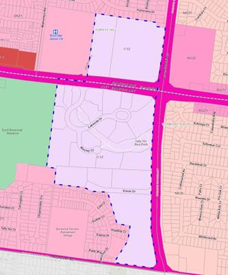
Figure 1 - Study Area includes land in the Commercial 1 Zone
(C1Z)
·
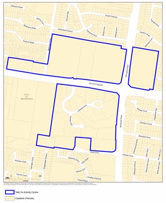
Figure 2 – Activity centre boundary (Clause 22.08
Whitehorse Planning Scheme)
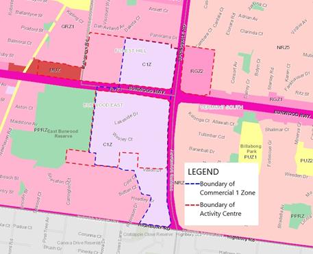
Figure 3 – Combined Activity Centre boundary and Commercial
1 Zone boundary
The aerial photograph at Figure 4 shows that the Study Area is
made up of the Poly Holdings site (A) on the north western corner of Springvale
Road and Burwood Highway, the Tally Ho Business Park (B) on the south western
corner of the intersection and a large tract of land adjoining to the south
owned by the Crossway Baptist Church (C). Other notable nearby sites include
the Burvale Hotel (D), the Peter James Centre (E) and the Quest apartments (F),
however these three nearby sites are not included in the Study Area as they are
not zoned Commercial 1.
·
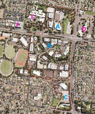
Figure 4 – Aerial photograph showing key landholdings
within and surrounding the study area
The resulting report from this work, Tally
Ho Commercial 1 Zone Review, July 2019 (the Review) confirmed that
performance indicators for the centre as an employment node are strong. There
are 3,500 jobs within the Study Area and those businesses currently located at
Tally Ho will continue to be relevant into the future, including headquarter offices
and government agencies. The Review concluded that there is a strong case for
retaining an employment focus for the Study Area. Following are the five
recommendations from the Review as presented to Council on 26 August 2019:
· Recommendation 1 - Revise
the existing Tally Ho Policy (clause 22.08) [of the Whitehorse Planning Scheme] to
make clearer the specific range of complementary uses that are supported by
Council within the Study Area (and under what conditions).
· Recommendation 2 -
Apply the Commercial 3 Zone (with a schedule which prohibits dwellings, but
which permits residential buildings with a floor area of up to 50% of the total
floor area of a building) to the entire Study Area, including the area north of
the Burwood Highway, and the Crossways Church site.
· Recommendation 3 - .
Apply a site specific control to the existing Crossways church site which
retains the same land use status for a place of worship that currently exists
under the Commercial 1 Zone.
· Recommendation 4 - In
the event that Council considers that a specific part of the Study Area needed
to be set aside for the provision of freestanding short-stay accommodation
and/or some form of a small ‘local activity centre’ comprising a small
supermarket and associated speciality shop uses, then part of the land could be
differently zoned to allow this.
· Recommendation 5 -.
Undertake a review of the existing built form controls that apply to the Study
Area in the coming years. The review should focus on ensuring that the high
quality building and landscape design vision established under the existing UDF
and Design Guidelines is achieved whilst at the same time supporting the
creation of a greater intensity and diversity of activities and also the renewal
and redevelopment of ageing building stock within the Study Area.
Recommendation 2 includes replacing the C1Z
in the Study Area with a Commercial 3 Zone (C3Z). The C3Z was introduced to the
suite of planning tools by the State government in September 2018 to help
facilitate business growth and innovation in select parts of Victoria. The
purpose of the C3Z is as follows:
· Providing for a range
of industrial, commercial, office and other employment generating uses which
support the mixed-use employment function of the area.
· Promoting
collaborative and high-quality working environments which support the area
through good urban design and high amenity, accessible and well-connected
places.
· Providing
opportunities for limited retail uses which are complementary to the role and
scale of the area.
· Providing the option
for limited residential uses that do not undermine the primary employment and
economic development focus of the zone.
· Facilitating the use,
development and redevelopment of land in accordance with the objectives
specified in a schedule to the zone
Planning Practice Note 85 – Applying
the Commercial 3 Zone (PPN85) indicates that the primary intent of the C3Z
is employment generation, and that the extent to which other land uses such as
retail and residential are accommodated, needs to be carefully managed.
The report to Council on 26 August 2019
provided a detailed outline of the key findings of the Urban Enterprise Review
report. Council resolved to note the contents of the Review and to
publicly release the report for a period of consultation.
DISCUSSION
Results of Consultation
The Review was made publicly available via Council’s
website and submissions were accepted over a six week period from 24 February
to 9 April 2020. During that period 11 submissions were received, 10 of which
were made on behalf of landowners within the Study Area and one of which was
made on behalf of a land owner elsewhere in the Tally Ho Activity Centre (refer
Figure 5). A list of submitters and their property of interest is at Attachment
3.
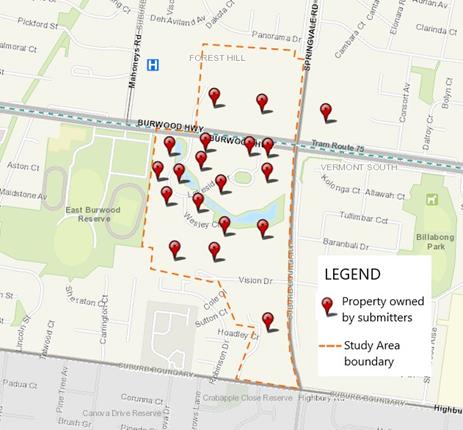
Figure 5 – Property location of submissions. Note: Some
submissions covered multiple properties
The consideration and assessment of submissions has been done
according to common issues/themes including:
· Use
of the Commercial 3 Zone (C3Z)
· The
Design and Development Overlay (DDO9)
· Status
of Tally Ho as an Activity Centre
· Crossway
Baptist Church
·
An overview of these issues, a response to each concern and a
recommended outcome is outlined below.
Use of the Commercial 3 Zone
– 10 submissions
There is concern from submitters
that the C3Z has not yet been tested in Victoria and it seems inappropriate to
test it on Tally Ho, especially while the Activity Centre is experiencing low
vacancy rates. Many submitters believe that the C3Z was introduced to
facilitate areas of growth for creative industries, small manufacturers and
start-up businesses rather than established tech companies and government
agencies.
There is a strong preference from submitters to retain the
C1Z across the Activity Centre or at least review the DDO9 as a first step in
stimulating investment and interest in the centre. Submitters generally see the
C1Z as the right zone to ensure flexibility for growth and economic viability
for the Activity Centre in the future although the suitability of the Mixed Use
Zone (MUZ) was also questioned as an alternative zoning.
Most
submitters believe that employment generating uses such as child care
facilities, gyms, short term accommodation, cafes and bars would benefit from
being co-located with offices. This would allow night-time and
after-hour activities to a commercial area that would otherwise be
‘dead’ and be at odds with the purpose of activity centre. Submitters believe that C1Z offers the greatest flexibility
for the establishment of these land uses.
Submission 2 from Tract on behalf of Welloyd Trust for the
sites at 378 and 380 Burwood Highway and 1 Lakeside Drive, Burwood East,
specifically commented that under the current C1Z there is no ability for an
applicant to propose a development entirely comprising accommodation land uses
without triggering a planning permit, and as such, Council has the ability to
facilitate and negotiate the final development outcome. The submission states
that the Review should more clearly identify and acknowledge the
‘condition’ associated with Accommodation in the land use table of
the C1Z.
Response
It is
agreed that the C3Z is a relatively new and
untested zone as it has still not been introduced
into a municipal planning scheme in Victoria. The benefits and drawbacks of the
C3Z are therefore yet to be properly tested through implementation.
Given its unfamiliarity, submitters may not be aware that
the intent of the C3Z is to foster a diversity of employment generating uses,
provide affordable floor space for such uses, and limit the displacement of
employment generating uses from productive areas. There appears to be concern
that the introduction of the zone will limit opportunities and flexibility for
uses that haven’t been part of the Tally Ho landscape previously. However
it is this desire to profit from residential development as a short sighted,
market-driven decision that may ultimately lead to the loss of commercial floor
area in Tally Ho and therefore to the detriment of its long term sustainability
for employment uses. The long term sustainability of Tally Ho was a
relevant pillar for the review and is a consideration perhaps amplified by the
anticipated changing nature of workplaces and desirability of suburban office
space in a ‘COVID-normal’ society.
Some submitters indicated that they saw the C3Z as being applied in former
industrial areas that require repurposing however, ‘Applying the
Commercial Zone Planning Practice Note’ (PPN85) indicates that a broader
application of the C3Z is possible. While former industrial precincts represent
one such area where the C3Z may be appropriate, PPN85 refers to the C3Z as a:
“New planning tool which can be applied to
help facilitate business growth and innovation in select parts of
Victoria”.
The ‘How to Apply the Zone’ section of
PPN85 references a need to:
“Evaluate the ongoing suitability of
established industrial and commercial areas for different types of
employment purposes, and determine whether such areas should be retained in an
existing industrial or commercial zone, or whether the Commercial 3 Zone
should be applied as a means of enabling broader mixed-use employment
outcomes” [emphasis added].
It can be
reasonably concluded from PPN85 that the C3Z is an appropriate zone to guide
and evolve future land use and development in an already well-established
commercial precinct. The C3Z does allow some complimentary uses (including accommodation, small-scale retailing,
places of assembly, and warehouses) that have the potential to contribute to
the amenity and economic vibrancy of the locality but with floor area
thresholds applied to reflect their role as small-scale activities within a
mixed use employment context.
The MUZ was not
considered to be a suitable option for Tally Ho. It has long been a criticism
that the MUZ is actually a residential zone and, given ‘dwelling’
is an as-of-right use, it offers limited ability to retain employment
generating uses (given the stronger market in recent years for residential
development). It was for this reason many traditional inner-employment precincts,
like Cremorne and parts of Fitzroy and Collingwood, remain in the Commercial 2
Zone, where ‘dwelling’ (and most other forms of
‘accommodation’) is a prohibited use. The C3Z is therefore considered
a more appropriate option for Tally Ho as it has a strong employment focus.
With respect to
Submission 2 it is acknowledged that accommodation uses must meet a condition
that restricts the use to above ground floor in order to not require a permit.
The nature of the issue being considered, is whether the extent of residential
development (in the form of dwellings / apartments) permissible under the
existing C1Z would support the overall economic strength and ongoing viability
of Tally Ho as a specialised office-based employment precinct. The condition is
not considered material to this question, as the opportunity to develop a
building primarily for accommodation in the zone without a permit clearly has
the potential to displace office floor space which currently occupies multiple
levels of buildings and the ability of sites to accommodate a greater amount of
office space into the future and as economic activity and businesses
re-activate post COVID19.
The conclusions
from the Review were that substantial residential development within the
precinct could materially change the role and function of the centre and risk
eroding the specialisation, value and employment role of the area. Given that
the use of land for accommodation is explicitly supported by the purpose of the
C1Z and that the use of land above the ground floor is ‘as of
right’ it would not be possible to refuse an apartment proposal under the
present zoning based on ‘use’ grounds alone. For this reason it is
considered that retaining the majority of the precinct within the Commercial 1
zone will create a significant risk that the role and function of the centre as
an employment precinct may be undermined by residential development over time.
It is acknowledged that the C1Z
retains the opportunity for the ground floor of buildings to remain
‘non-residential’. However, where land is to be used for apartments
on the upper levels, the predominant use of the land is not commercial in
nature (which is the desired outcome across the precinct). Further, the quantum
of commercial floor space that can be created on the ground floor of an
apartment building is significantly constrained by the need to set areas aside
for vehicle access, services, lobbies, waste storage, bicycle car
parking. Therefore the resulting ground floor commercial floor space
outcome associated with apartment buildings is very modest (usually catering
for retail and hospitality uses, albeit these may complement the office
functions of the centre) and will not result in the creation of the type of
commercial floor space outcomes desired under policy
for this precinct.
Subsequent to the consultation
period, the operation of the C3Z has been further clarified with DELWP to
better understand the floor area calculations. Advice from DELWP is that the
intent of the schedule is that the Gross Floor Area (GFA) percentage (%) cannot
be further broken down between ‘dwellings’ and ‘residential
buildings’ (i.e.: apportioned as a % to a dwelling and as a % to a
residential building). Only one rate (%) may be specified in a schedule to the
C3Z and it applies to both uses in totality.
However, consultants for the Review remain of the opinion
that ‘dwellings’ and ‘residential buildings’ can be
separately specified in the schedule to the C3Z. In light of the
submissions and the scope for a master-planned approach for larger
redevelopment sites, Recommendation 2 of the Review has been amended by Urban
Enterprise to allow up to 35% of the gross floor area on the Poly Holdings and
Crossway Church sites as dwellings as part of a masterplan and in locations on
the sites that transition to residential interfaces.
The updated recommendation is shown in the Tally Ho
Commercial 1 Zone Review (July 2019) revised December 2020 at Attachment
1 as follows:
Apply the Commercial 3 Zone across the study area with
schedules which apply the following controls:
· Tally Ho Business Park:
o Prohibit dwellings (i.e.
0%); and
o Permit residential
buildings (e.g. hotels, short stay accommodation) with a floor area of up to
50% of the total floor area of a building;
· Former HP [Poly Holdings] site:
o Permit residential
buildings with a floor area of up to 50% of the total floor area of a building
anywhere within the site; and
o If it is determined via
a masterplanning process that some limited residential uses might be
permissible (as a transitional use in the northern part of the site) apply the
default schedule for dwellings (35% of the floor area of a building) via a
schedule to that part of the site only.
Based on the advice from DELWP and the views of the
consultants, it is proposed to take the lower of the percentages recommended by
UE in each of the above precincts (consistent with the intent to give primacy
to employment floor space) and apply these to both dwellings and
residential buildings (consistent with DELWP’s advice) as follows:
· Set
the combined percentage of GFA for ‘dwellings’ and
‘residential buildings’ at zero (0%) in the Tally Ho Business Park (including land on the north side of
Vision Drive) to effectively prohibit these uses.
· Allow
the default in the C3Z of up to 35% of the combined GFA of all buildings on the
Poly Holdings and the Crossway Church sites to be for ‘dwellings’
and ‘residential buildings’.
Given the infancy of the C3Z it is considered appropriate
for opinion on the structure of the zone to be fully explored during exhibition
of the planning scheme amendment and at a future independent panel (should this
be required) where submitters have the opportunity to be heard.
Recommended outcome
Updates have been made to the Tally Ho Commercial 1 Zone
Review prepared by Urban Enterprise (July 2019) revised December 2020 as
noted above (refer Attachment 1).
It is considered that
Recommendation 2 of the Review to apply the C3Z to the Study Area is
appropriate but the schedule to the zone should be used to:
· Prohibit dwellings and residential buildings in the Tally
Ho Business Park, including the portion of the Crossway Baptist Church land
located north of Vision Drive.
· Limit dwellings and residential buildings to the default
total GFA of up to 35% of the total GFA of all buildings on the land for the
remainder of the Study Area being the Poly Holdings and the portion of Crossway
Baptist Church land located south of Vision Drive.
Revisions made to the Urban Enterprise report in December
2020 also include commentary on the impact of COVID-19 on the office sector and
the importance of providing flexibility
and opportunity for a range of business types, premises and developments to
occur. This further justifies use of the C3Z.
Design and Development Overlay
- 8 submissions
The land in the Study Area, excluding the Crossway Baptist
Church site, is covered by a DDO9. The DDO9 was introduced through Amendment
C110 which was approved by the Minister for Planning on 22 October 2015. The
Amendment implemented the Tally Ho Major Activity Centre Urban Design
Framework 2007 (also making it a permanent reference document in the
planning scheme) and subsequent work on the Tally Ho Urban Design and
Landscape Guidelines 2013. The DDO9 includes Development Guidelines that
provide preferred building heights (variously from 7 metres to 20 metres across
the DDO), setbacks, and preferred landscape, streetscape and fencing
treatments.
One of the most frequently raised concerns in submissions
related to DDO9. Submitters expressed that the building heights allowed under
the DDO9 are too restrictive and that they are stifling growth and investment
and discouraging development in the activity centre. Submitters are concerned
that while internal fit-outs can cater for some change, actual floor space is
limited. It is claimed that this problem is further exacerbated by the fact
that Tally Ho’s building stock is ageing and often does not meet the
needs of larger and expanding anchor tenants.
There is concern that the DDO9 is out of date and the building
heights do not align with current planning, design and development outcomes
anticipated in a Major Activity Centre. Many of the submitters believed that a
review of the DDO9 (building heights) would be more beneficial to the success
of the Activity Centre than a rezoning.
Response
The main focus of this study was
to review the suitability of the C1Z for the on-going success of land use in
the Tally Ho Activity Centre. Reviewing the DDO was not considered to be a high
priority given that the Tally Ho Urban Design and Landscape Guidelines 2013,
were prepared relatively recently and implemented in the planning scheme in
2015.
The building heights specified in the DDO9 are preferred
heights and can be increased if a permit application demonstrates how the
development will meet certain outcomes and requirements of the DDO.
It is considered that the existing DDO that applies to the
Activity Centre addresses the necessary range of design and built form
measures. Whilst at a future point further analysis of the built form framework
that applies to Tally Ho may be desirable, the suitability of using the DDO as
a tool to define the desired built form outcomes is appropriate and was
ultimately supported by the Panel for Amendment C110 which implemented DDO9. In supporting Amendment C110, the Panel agreed that the
preferred controls would allow flexibility where the built form outcome did not
compromise the integrity of the 2007 UDF and 2013 Guidelines.
The Panel noted the strategic work
underpinning the DDO9 and the consistency between the 2007 UDF and the
subsequent 2013 Guidelines, and that the amendment implemented the relevant
sections of the State and Local Planning Policy Framework. It is acknowledged
that the Panel referred to a lack of formal review of the 2007 UDF when it was
first introduced in an interim way in Clause 22.08. However the Panel also
noted that Amendment C110 “provided an opportunity to express views
about the provisions proposed to implement the 2007 UDF”[1].
The Panel suggested a future review of the 2007 UDF and any subsequent updates
to the 2013 Guidelines accordingly “to ensure that the preferred
heights are still relevant and that they align with realistic benchmarks”[2]. The
Panel viewed this as a separate process to Amendment C110.
To date, there has been very
little test of the DDO9 through subsequent planning applications to conclude
that the built form controls in the overlay are not suitable.
Recommended
Outcome
Recommendation
5 of the June 2019 Review includes undertaking a revision of the
existing built form controls that apply to the Study Area in the coming years
via a separate body of work. At this time the focus of the Review is
determining the most suitable zone to guide land use in the Study Area to ensure
the on-going economic viability of the Activity Centre. Further review of built
form may be contemplated at a future date and subject to budget approval,
however it is reiterated that the DDO9 was introduced relatively recently.
Recommendation 5 of the Review has
been amended accordingly to consider potential review of the DDO9 into the
future. This is shown in the Tally Ho Commercial 1 Zone Review prepared
by Urban Enterprise (July 2019) revised December 2020 at Attachment 1.
Status of the Tally Ho Activity
Centre / Clause 22.08 policy - 5 submissions
Tally Ho is identified in the
metropolitan planning strategy, Plan Melbourne 2017 – 2050, as a
Major Activity Centre. Clause 22.06 of the Whitehorse Planning Scheme provides
the policy basis for all of the activity centres across Whitehorse and outlines
the objectives to be achieved. Clause 22.08 specifically relates to the Tally
Ho Activity Centre and identifies the centre as a key eastern suburbs office
and technology hub with high quality built form set in extensive landscaped
gardens.
While Clause 22.08 acknowledges
Tally Ho’s economic importance and high amenity aspects, some submitters
claim that the importance of the Activity
Centre for employment could be reinforced by strengthening the Local Policy at
Clause 22.08 rather than undertaking a land rezoning. There is concern that
rezoning land to Commercial 3 Zone is contrary to the policy position at Clause
22.08 of the Whitehorse Planning Scheme in relation to Economic Sustainability
which states that it is policy to:
· Develop a greater mix of complementary uses of high need,
notably retail, business services, short term accommodation and high quality
conferencing facilities.
· Facilitate improvements to the capacity and flexibility of
building stock.
· Develop a greater range of residential opportunities.
· Prioritise affordable housing, aged-care housing,
specialist housing, serviced apartments and hotel facilities.
In this
regard, submissions expressed concern
that the recommendations of the Review are counter to Clause 22.06 and Clause
22.08 of the Whitehorse Planning Scheme which encourage a wider mix of uses
including opportunities for housing.
Response
The
submissions fail to acknowledge that while Tally Ho is identified as an
Activity Centre in both State and local planning policy it operates differently
to those other designated Activity Centres in Whitehorse including Forest Hill
Chase, the Whitehorse Road Nunawading/MegaMile and Burwood Heights. Moreover,
there are very few activity centres that are directly comparable to Tally Ho in
suburban areas and in the eastern region with a major focus on office floor
space, considerable health uses nearby, access via public transport and only
secondary retail uses present.
It
is agreed that strengthening Clause 22.08 would aid in supporting the vision
for Tally Ho. This is reflected through Recommendation 1 of the Review that is
to:
Revise the existing Tally Ho Policy (clause 22.08)
to make clearer the specific range of complementary uses that are supported by
Council within the Study Area (and under what conditions).
However strengthening the
policy alone will not address the potential loss of employment floor space
under the current C1Z where certain uses, such as accommodation, education
centre and retail premises, remain as of right.
The
submissions also overlook the Burvale Hotel site, which is included in the
Tally Ho Activity Centre, provides approximately 11 acres of land in the
Residential Growth Zone (RGZ2) and therefore has potential for future
residential development in addition to the RGZ corridor along Burwood Highway
neighbouring Tally Ho and the former ATV-0 site to the north.
Although
Tally Ho is designated as an Activity Centre its operation is quite specialised
in that it plays an important economic role in the Whitehorse and eastern
Melbourne region. Economic analysis undertaken as part of the Review has found
that the centre is performing well so any future uses shouldn’t inhibit
its specialised role.
The other
issue that should be addressed through this review process is the discrepancy
between the boundary of the commercial zone and the Activity Centre boundary.
The map in Clause 22.08 currently excludes land owned by the Crossway Baptist
Church (as shown in Figures 2 and 3). This is inconsistent with the Tally Ho
Urban Design Framework (UDF) 2007 that was implemented through Clause
22.08 and the Tally Ho Activity Centre Urban Design and Landscape Guidelines
(updated 2015) implemented through the Design and Development Overlay Schedule
9 (DDO9).
Although
there is significant discussion in the Panel Report for Planning Scheme
Amendment C110 about excluding Forest Ridge and the low density residential
areas from the Tally Ho Activity Centre the Panel did not recommend that
Crossway Church be excluded. The Panel Report stated:The Panel
believes that the Crossways Baptist Church land has more opportunities to
integrate with Precincts 3 and 4 than Forest Ridge has with other precincts.
The church land is also of a smaller scale compared to Forest Ridge.
By this
time Council had already supported a separate strategic planning exercise
through Planning Scheme Amendment C123 and the application of the Development
Plan Overlay to the Crossway Church site. However, Council submitted Amendment
C110 to DELWP for approval with the Crossway Church site included in the
Activity Centre boundary. An update to the Clause 22.08 map appears to
have inadvertently excluded the site.
Recommended
outcome
Recommendation 1 of
the Review includes revising the existing Tally Ho Policy (clause 22.08) to
make clearer the specific range of complementary uses that are supported by
Council within the Study Area (and under what conditions). Revising this local
policy would also provide an opportunity to highlight the point of difference
between Tally Ho and other Activity Centres in Whitehorse and across
Metropolitan Melbourne and provide a stronger basis for guiding discretion
around land uses under the future zone.
Revisions to
the policy at Clause 22.08 should also include updating the Tally Ho Activity
Centre Precinct Plan to correctly identify the Crossway Church site as
being in the Activity Centre.
Crossway Baptist Church
The submission from Crossway Baptist Church
focusses on the Crossway owned parcels which are located primarily between
Vision Drive and Highbury Road. These parcels make up one of the larger land
holdings within the Review covering an area of almost 15 acres. While the
Crossway Church site is not affected by the DDO9, it is covered by a
Development Plan Overlay (DPO4) gazetted via Amendment C123 in October 2013. The
DPO4 directs most future use and development to the northern (elevated portion)
of the site as well as on the allotment on the north side of Vision Drive ensuring that any development on the site is in
accordance with an approved Development Plan.
The written submission and
discussions with Crossway Church have revealed that the church would like to
retain future flexibility to develop the site for a range of church uses and
non-church related uses, including development of the lower portion of the site
closer to Highbury Road. During these discussions Council officers have
reminded church representatives that there are significant stormwater and
infrastructure constraints to development on the lower portion of the site
toward Highbury Road which would need consideration as part of any future
development aspirations.
The church
asserts that the proposed planning changes on the site would significantly
impact the long-term security of the operation and the value of the land, which
in turn would significantly constrain Crossway’s ability to borrow funds
for future development. Advice sought by the church has found that the
valuation of its land would decline by more than 30% (representing a capital
loss in the range of $25-30 million) as the
C3Z would prevent some types of residential development and most types of
retail development. Crossway Church also later submitted a valuation report
prepared by Charter Keck Cramer to substantiate their submission.
There is concern from the church that if the C1Z is
replaced with the C3Z, the existing land use as a Place of Worship would
effectively become a prohibited use with significant negative implications and
that the future of the site would also be considerably constrained. Crossway Church opposes the
proposed rezoning believing that a significant number of uses would no longer
be permitted in the new zone, such as retail and residential uses. There is
also concern that residential development would be limited in scope to a
percentage of the land area.
Response
The
Crossway Baptist Church site presents differently to the rest of the Study Area
in terms of its current land use. Discussions with the Crossway Church have
indicated that it wishes to maintain the Place of Worship function on the site
but to explore options for other land uses on the site, particularly on the
lower portion of the site on the corner of Springvale Road and Highbury Road. It
has been noted above and in the discussions with the church that use and
development of the Crossway Church site is already strongly tied to an approved
Development Plan under the existing DPO.
Prior to the
zone reforms and during the Amendment C123 process, the Crossway Church site
was zoned Business 2 (B2Z), the purpose of which was to encourage the
development of offices and associated commercial uses and required a permit for
a place of worship. The Ministerial Amendment that introduced the C1Z allowed
the church to enjoy a wider range of uses permitted than under the previous
B2Z, including retail, office, business, entertainment and community
uses.
In the
existing C1Z a Place of Worship is an as of right use conditional upon the
gross floor area of all buildings not exceeding 250 square metres. In the
proposed C3Z a Place of Worship is a permit required use and the leasable floor
area must not exceed 250 square metres.
While the church has indicated that it intends to remain on
the current site, from a strategic point of view it is important for Council to
ensure that this land is zoned appropriately for the long term future and
benefit of the Tally Ho Activity Centre. While Crossway Church is the
current landowner and occupier, this does not prevent them from deciding to
relocate or dispose of land into the future if they are not committed to their
current location or the extent of the church’s use and development of the
land. This approach, not only towards Crossway Church but also to other sites
in the study area, is a reflection of Council’s responsibilities under
the Planning and Environment Act (The Act), 1987 to establish
a framework for planning the use, development and protection of land in
Victoria in the present and long-term interests of all Victorians.
Given the sensitive residential interface to the west and
south of the site, it is considered that a zone with a major retail component
(as would be allowed under the C1Z) would be inappropriate. Also, several
substantial retail centres already service the area, including Burwood One,
Vermont South Shopping Centre and The Glen. While Crossway is part of the Study
Area (given it is C1Z), it is not part of the
Tally Ho Activity Centre (as shown on the map at Figure 2).
It is acknowledged that the church
is concerned about how a potential rezoning will impact its financial position.
Existing use rights will allow the continuation of the current uses on the
site. It is understood that the financial concerns that have been raised relate
to benefits of potential land uses under the C1Z on the value of the land,
their borrowing capacity and future income stream opportunities, rather than
any wider reaching social and economic effects.
There are many factors that
influence land value including location, amenity, recent sales results and
property improvements. Several planning panels have considered the issue
of property values, and there is a long held view in both panel reports and in
case law that property devaluation is not a valid planning consideration. Panel
reports for Amendment C3 to the Yarra Planning Scheme and Amendment C18 to the
Stonnington Planning Scheme provide examples of this.
Recommended outcome
As noted above under “Use of the Commercial 3
Zone”, it is recommended that the Crossway Church site be included in the
C3Z and limit dwellings and residential
buildings to the default total GFA of up to 35% of the total GFA of all
buildings on the lot.
The current
DPO4 should be retained to guide use and development of the land and a Specific
Controls Overlay (SCO) applied. The SCO will allow the application of specific
controls designed to achieve a particular land use or development outcome in
extraordinary circumstances. This would allow the church’s intentions for
the site in terms of the Place of Worship and associated community uses to
continue under the C3Z. This would confirm the site’s existing use rights
and confirm continued development in accordance with the intention of the
approved Development Plan.
Proposed planning controls
It is proposed to manage the
economic future and success of the study area through planning scheme changes
including rezoning land, the application of a new overlay to the Crossway
Church Site and updates to the existing policy. Planning scheme amendment documents
have been prepared for Amendment C232whse and are at Attachment 2.
Below is an outline of the proposed zone changes:
Clause 22.08 – Tally Ho
Activity Centre
The Tally Ho Activity Centre Policy
at Clause 22.08 has been strengthened by specifying that any new land uses,
particularly accommodation uses, must complement and support the primary
employment role of the activity centre. Any residential land uses in the Study
Area should serve as a secondary function of the Activity Centre, such as a residential
hotel or other visitor accommodation.
The changes to the policy better
define the commercial core that sits within the activity centre boundary and
supports small-scale
complementary uses such as convenience retailing,
child care centres and food and drink premises, especially at ground
level to supplement the primary employment function of the centre.
Another change to the Policy at
Clause 22.08 includes updating the Tally Ho Activity Centre Precinct Plan to correctly
identify the Crossway Church site as being in the Activity Centre.
Clause 34.03 - Commercial 3 Zone
The C3Z is a new planning zone that
has been included in the Victorian Planning Provisions (VPP) that has been
created to complement the existing Commercial and Industrial Zones. The C3Z was
developed to ensure the provision of a sufficient supply of commercial land to
support business growth and innovation in Victoria .The intent of the C3Z is to
foster a diversity and critical mass of employment generating uses, provide
affordable floor space for such uses, and limit the displacement of employment
generating uses from productive areas. The C3Z is considered to be the most
suitable choice for ensuring that the employment role of Tally Ho is maintained
and enhanced.
The C3Z applies a default maximum
allowable gross floor area percentage requirement for residential
‘dwellings’ and ‘residential buildings’ of 35% of the
total gross floor area of all buildings on the lot. However the schedule to the
C3Z can specify a different percentage requirement. It is proposed to have two
schedules to the C3Z; one for the core Tally Ho Business Park (as shown as Area
B in Figure 4) specifying 0% for ‘dwellings’ and ‘residential
buildings’ and a second schedule for the Poly Holdings and Crossway
Baptist Church site south of Vision Drive (as shown as Areas ‘A’
and ‘C’ respectively in Figure 4) using the default maximum
allowable gross floor area for ‘dwellings’ and ‘residential
buildings’ under the C3Z (i.e.: 35% of the GFA).
The proposed floor area percentage
proposed for the Crossway Baptist Church site is contrary to the recommendation
of Urban Enterprise. The consultants did not consider that this site was
suitable for residential uses, fearing a further erosion of commercial land
use. However given the current use of the site, and the existing Development
Plan Overlay, it is considered that the default maximum requirement for
residential uses will allow the church to provide some accommodation in
association with their existing function without overwhelming the site with
residential uses.
Clause 45.12 - Specific Controls
Overlay
The primary use of the Crossway
Baptist Church site as a Place of Worship is acknowledged and there is no
intention for this to be compromised. It is proposed to apply a Specific Controls
Overlay (SCO) to the church’s site to enable
specific controls to override other requirements of the planning scheme in
regard to Place of Worship and associated community care accommodation.
This SCO will mean that the church
site may be used or developed in accordance with a specific control contained
in an Incorporated Document that is specified in the schedule to the overlay.
The SCO may:
· Allow
the land to be used or developed in a manner that would otherwise be prohibited
or restricted.
· Prohibit
or restrict the use or development of the land beyond the controls that may
otherwise apply.
· Exclude
any other control in this scheme.
An Incorporated Document has been prepared for the Crossway
Church site and forms part of the planning scheme amendment documents at Attachment
2.
CONSULTATION
On 24 February 2020 letters were sent to approximately 90
landowners and occupiers in the Commercial 1 Zone of Tally Ho and to the
neighbouring Burvale Hotel and Peter James Centre. The letter provided a link
to access the Tally Ho Commercial 1 Zone Review on Council’s
website. The letter also invited people to a drop in session on 19 March 2020 at
the Quest in Burwood East if they had further questions or comments, however
this event was cancelled due to the impact of COVID-19. Given the cancellation
of this event the comment period was extended to Thursday 9 April 2020,
providing a consultation period of over six weeks.
If Council resolves to proceed with a planning scheme
amendment and if authorisation is granted by the Minister for Planning to
prepare and exhibit the Amendment, the statutory exhibition period will allow
for further public comment and any future panel hearing will provide
independent review of submissions received and the proposed planning controls.
Preliminary feedback from the State government
DELWP has
indicated that the C3Z may be suitable for the Study Area subject to a
planning scheme amendment process. Tally Ho is identified as a Regionally
Significant Commercial Area in DELWP’s Melbourne Industrial and
Commercial Land Use Plan 2020. The plan acknowledges that: Tally Ho Major Activity Centre acts as a regional
employment node with significant office space accommodating a range of
professional services as well as government offices and headquarters for large
corporations. These centres are supported by a range of large and small
neighbourhood activity centres.
DELWP has acknowledged that using the C3Z would assist in
protecting the Study Area for employment purposes, contributing to the longer
term aim of supplying an appropriate amount of employment generating land uses
to serve the needs of metropolitan Melbourne.
The Department has however expressed concern about the 50%
floor area proposed in the Review citing that housing capacity is being met
outside the Study Area. It is therefore proposed to limit
dwellings and residential buildings to a total gross floor area of up to 35% of
the total floor area for the Poly Holdings and Crossway Baptist Church land
being the default percentage in the C3Z.
FINANCIAL
IMPLICATIONS
|
|
Budget
|
Expenditure
|
|
Tally Ho Review of the Commercial 1 Zone prepared by Urban
Enterprise (completed)
|
$30,000
|
$29,990
|
|
|
|
|
|
Future Amendment Costs (proposed):
|
|
|
|
- Exhibition
costs
|
$4,000
|
|
|
- Statutory
Fees (consideration by the Minister for Planning)
|
$4,371
|
|
|
- Planning
Panel cost estimate (if required)
|
$20,000
|
|
|
- Expert
witness at Planning Panel (if required)
|
$15,000
|
|
|
Subtotal – Future Amendment Costs
|
$43,371
|
|
|
|
|
|
|
Total Budget
|
$73,371
|
|
POLICY IMPLICATIONS
Strategic Direction 5 of the
Council Plan 2017-2021 is to support a healthy local economy. Goal 5.1
of the Plan is to work in partnership to support a strong, active local
economic environment that attracts investment and provides economic
opportunities for businesses and employment for people. The Review of the
Commercial 1 Zone at Tally Ho recognises the strength of the centre which
contributes to economic activity and employment growth. Addressing the zoning
issues at Tally Ho will ensure that land for employment generating uses is
maintained and not lost to residential.
conclusion
While there is uncertainty about the property market and
investment in a post COVID environment, this strategic work has its sights on
the longer term vision for broader economic and community benefit. The
revisions made to the Urban Enterprise Report include a December 2020 update
reflecting on the impact of COVID-19 on the office sector and the importance of
providing flexibility and opportunity for
a range of business types, premises and developments to occur.
There has been a gradual chipping away of employment based
land in the inner and middle ring suburbs of Melbourne for the past 30 years,
which has had a significant impact on local economies. Once that land is lost
to residential there is no reclaiming it for employment generating land uses.
There have been unintended consequences of the Zone Reforms of 2013 that have
potentially contributed to this problem
The C3Z has been
studied and is considered to have merit for application to the Study Area.
Notably, the C3Z makes repeated reference to the primary purpose of the zone
being for ‘employment and economic development’ with a
‘mixed-use employment’ focus. The zone allows ‘office’
as an as of right use. It does not prohibit ‘dwelling’ or
‘residential building’ but allows the schedule to the zone to specify
a zero percentage requirement for residential uses provided there is a
strategic basis established through the planning scheme amendment process.
The C3Z is another tool in the Victorian Planning Provisions
that is available to apply to those areas seeking to maintain and better
protect employment generating land uses. While the zone is untested in Victoria
it is considered to be a sound option for Tally Ho’s economic success
into the future.
Attachment
1 Tally Ho
Commercial 1 Zone Review (July 2019) revised December 2020 
2 Planning Scheme
Amendment Documents 
3 List of
Submitters 
Council Meeting 27
January 2021
9.2 Infrastructure
9.2.1 Extension
and Amendment to Maximum Expenditure Threshold (Contract 15042) Provision of
Weed Control Services
SUMMARY
The purpose of this report is to
seek approval to extend Contract 15042 – Provision of Contract Weed
Control Services and amend the maximum expenditure threshold.
Contract 15042 Provision of Weed
Control Services is due to expire on 20 September 2021. The Contract includes
an option for Council to extend the contract until 20 September 2022
As part of the extension, approval is sought to increase
the maximum expenditure threshold that was approved by Council on 19 September
2016 from $1,125,000 to $2,000,000 excluding GST.
|
RECOMMENDATION
That Council:
1. Approves
the contract extension for Contract 15042 – Provision of Contract Weed
Control Services to 20 September 2022 with the following:
a) Telamo
Pty Ltd A.B.N. 43 088 081 869 of 11 Rowling Street Plumpton Victoria 3335
trading as “Rays Weeds Spraying Service” for Garden Beds, Items
6, 7 & 8, Block Items 15 & 16, Broadleaf Items 1, 2 & 4, Hard
Surfaces Items 9-14 and Grass Cutting Items 17, 18 & 19.
b) Harricks
Services Pty Ltd A.B.N. 83 088 248 088 of 818 Warburton Hwy Seville Vic 3139
trading as “Wipe Out Vegetation Management” for Garden Beds,
Items 6, 7 & 8, Block Items 15 & 16, Broadleaf Items 1, 2 & 4, Hard
Surfaces Items 9-14 and Grass Cutting Items 17, 18 & 19.
c) Landlinks
Environmental Services Pty Ltd A.B.N. 53 078 936 151 of 100 Morbey Rd
Gembrook 3783 Vic PO Box 277 Gembrook 3783 or Garden Beds, Items 6, 7 &
8, Block Items 15 & 16, and Broadleaf Items 1, 2 & 4.
d) Herbert
Group Holdings Pty Ltd A.B.N 80 602 813 454, 1/375 Bayswater road Bayswater
PO Box 204 Bayswater 3153 trading as “Herbert Contractors”
for Grass Cutting Items 17, 18 & 19 and Hard Surfaces Items 9-14;
and
2. Approves
a maximum expenditure threshold of $2,000,000 excl GST for Contract 15042
– Provision of Contract Weed Control Services Panel.
|
background
The Council Plan sets strategic
directions to ‘Maintain and enhance our built environment to ensure a
liveable and sustainable city’ and ‘Protect and enhance our open
space and natural environment’.
Contract 15042 – Provision of
Contract Weed Control Services Panel was awarded to Telamo Pty Ltd, Harricks
Services Pty Ltd, Landlinks Environmental Services Pty Ltd and Herbert Group Holdings
Pty Ltd at the Council Meeting in September 2016 with an initial Contract term
of five years that commenced on 20 September 2016, with an option to extend the
contract for a further one year at Council’s discretion.
This Contract is for the provision
of Weed Control Services across Council managed land. Council manages and
maintains a geographic area of 64 square kilometres with 611km sealed roads,
1,182km foot paths kerb and channel, 30.8km constructed laneways, 18km
unconstructed laneways, 86km of sealed paths, 95km of gravel paths and trails,
and 590 hectares of open space comprised of parks, bushland reserves,
landscaped gardens, recreation reserves, community centres, together with
tree-lined residential streetscapes including shops, centre medium strips,
outer separators and traffic management devices. These open space and
horticultural assets are maintained through a combination of in-house resources
and specialist contractors.
Legislation requires Council to
control a range of weed types and as such, maintenance programs have been
developed to meet this requirement. Minor and small scale weed control
works are undertaken by Council’s staff however bulk volume and large
area weed control works are outsourced to specialist weed control contractors.
This Contract is for the provision
of weed control services to Council’s entire open space network and the
provision of mowing, brush cutting and slashing services to open space, Council
maintained nature strips and laneways. It includes the use of herbicide under
best practice application methods to control environmental, noxious and general
weeds within open space.
It is recognised that some members
of the community are concerned about the use of chemicals in the environment
and alternatives continue to be explored. Whitehorse and the Municipal
Association of Victoria (MAV) have engaged Deakin University to undertake a
research project looking at the safety, effectiveness, financial implications
and potential soil impacts of alternative weed control methods. While this
research is being undertaken, Council’s use of glyphosate continues to be
guided by the Australian Pesticides and Veterinary Medicines Authority (APVMA)
and WorkSafe who are the regulatory authorities in this space. The APVMA has
clearly stated that APVMA-approved products containing glyphosate can continue
to be used safely following the directions in the Safety Data Sheet and the
labels.
DISCUSSION
The contractors currently
undertaking work under this Contract do so to a high standard in accordance
with the specification and in line with all regulatory and Occupational Health
and Safety requirements. In response to the satisfactory performance, it is
recommended that the one year extension option be granted.
The Weed Control Services contract
commenced on 20 September 2016 and the total expenditure threshold was approved
at $1,125,000 over five years. This figure was based on the total expenditure
of the previous amount of work undertaken under the weed control Services
Contract that expired in 2016.
Increasing the term of Contract
requires the maximum expenditure threshold to be increased and the amount
estimated is greater than simply adding one fifth of the original amount. Since
the original estimate of overall Contract expenditure was made, seasonal
conditions including higher rainfall (particularly over the past few years)
have resulted in an increase of weed works control across the Municipality. A
number of newly completed projects including new parks have also increased the
amount of vegetation and weed management required to be undertaken.
CONSULTATION
Staff from Council’s
Procurement team have assisted with providing current contract expenditure
details and advice on this process in line with Council’s adopted
Procurement Policy.
FINANCIAL IMPLICATIONS
There are no financial implications
associated with this report. This is a schedule of rates contract an all
expenditure incurred against this contract is in accordance with the relevant
adopted annual budgets.
Council Meeting 27
January 2021
9.3 Corporate
9.3.1 Audit and
Risk Committee: Appointment of Independent Member
FILE NUMBER: SF08/319
SUMMARY
As a result of the Local
Government Act 2020 now requiring a majority of independent members on its
Audit and Risk Committee (currently two) Council advertised and received 29
applications for the position of third independent member of the Audit and Risk
Committee (ARC). Four applications were short listed and interviewed by a
selection panel convened by an Independent Local Government Consultant and
included the current Chair and Independent Member of the ARC. The panel
recommends that Council appoint Jonathan Kyvelidis to the position.
|
RECOMMENDATION
That Council:
1. Appoint
Mr Jonathan Kyvelidis as the third independent member on the Audit & Risk
Committee for the term commencing 1 March 2021 to 31 August 2024, with
performance based options for extension for a further three year term.
2. Approve
continued remuneration for the role at $1,400 per meeting for a maximum of
five meetings per annum.
|
background
Under the terms of the Audit & Risk Charter 2020,
independent members will be appointed for an initial period not exceeding three
years after which they will be eligible for extension or re-appointment, for a
further three-year term after a formal review of their performance. The
Charter does not preclude an end-of-term member from reapplying for the
position.
Pursuant to Section 53 of the new Local Government Act
2020, Councils must establish an ARC and that committee must consist of a
majority of members who are not Councillors of the Council and who collectively
have expertise in financial management and risk; and experience in public
sector management. As a consequence of these provisions Council was required to
recruit a third independent committee member, with the composition of the
committee now being two Councillors and three independent members
An advertisement inviting applications from interested
individuals was placed in The Age on 31 October 2020 as well as
Council’s Employment Website, with a closing date of 20 November 2020.
Twenty-nine applications were received. The Independent Consultant engaged to
facilitate the recruitment process and Council’s HR Business Partner
reviewed and considered all applications after which four were short listed on
the basis of the level of their conformity with the skills matrix criteria
developed for the recruitment process as well as the following key criteria:
· Relevant
qualifications and technical expertise
· Strong
financial literacy
· Proven
experience in public sector management
· Experience
in audit and knowledge of local government
· Knowledge
of legislative compliance, risk management, public integrity and data
governance.
The four short listed applicants were subsequently
interviewed. Interviews were held by a panel convened by the Independent
Consultant and included the Chair and Independent Member of the Audit &
Risk Committee.
At interview, a ranking process was used to score each
candidate on the published selection criteria. The panel considered
Jonathan Kyvelidis to be the preferred candidate when assessed against all of
the selection criteria.
DISCUSSION
The recommended
applicant is Jonathan Kyvelidis who has qualifications including a Masters of
Business Administration, Bachelor of Commerce, Graduate Diploma - Institute of
Chartered Accountants, ASIC Registered Company Auditor and an Affiliate
Membership of the Australian Institute of Managers and Leaders. These
qualifications combined with a strong professional background including a nine
year career at the Victorian Auditor General’s Office (2011-2020)
including the position of Sector Director Local Government, make Mr Kyvelidis
an outstanding applicant.
Mr Kyvelidis
brings an excellent understanding of sector issues including governance, risk,
compliance and accountability obligations. He is also a current member of
the Baw Baw Shire ARC.
In addition, Mr Kyvelidis
demonstrated passion, energy and commitment to make a contribution to the Local
Government sector. He specifically identified Whitehorse as an ARC role he
would like, and demonstrated values and behaviours that are being sought by the
Committee and would complement other members’ skills and experience.
Finally, Mr Kyvelidis possesses
public sector management experience and a strong understanding of risk, public
integrity functions including through his previous role with VAGO and, while
there, with the Local Government Inspectorate and IBAC.
CONSULTATION
The recruitment process was
conducted by an Independent Local Government Consultant, the Chair and
Independent Member of the Audit & Risk Committee.
FINANCIAL
IMPLICATIONS
Remuneration for an independent
member of the Audit & Risk Committee was previously approved at $1,400 per
meeting (for 5 meetings) or $7,000 per annum and is recommended to continue at
this level.
The recruitment process incurred
costs for advertising and services of the Independent Consultant were
approximately $9,000.
Council Meeting 27
January 2021
9.3.2 Emergency
Management Arrangements
SUMMARY
Local
Governments are required under the Emergency Management Legislation Amendment
Act 2018 (Act) to align its Municipal Emergency Management Planning Committee
(MEMPC) with the reformed emergency management planning arrangements outlined
in the Act.
The Act also
amends a number of associated pieces of legislation and the Emergency
Management Act 2013. The legislative changes align State, Regional and
Municipal emergency management planning arrangements.
|
RECOMMENDATION
That Council:
1. Authorises the disestablishment of the
existing Municipal Emergency Management Planning Committee (MEMPC)
established under ss.21(3)-(5) of the Emergency Management Act 1986, in
recognition that on 1 December 2020 these provisions were repealed by s.82(2)
of the Act and replaced by the provision ofs.68 of the Act.
2. Authorises
the Chief Executive Officer or delegated Senior Officer to facilitate the
establishment of the Municipal Emergency Management Planning Committee
(MEMPC) in accordance with the provisions of s.68 of the Act (which inserts a
new Part 6 - Municipal Emergency Management Planning Committees into the Act
on 1 December 2020.
3. Notes
that, under Municipal Emergency Management Planning Committee (MEMPC) Terms
of Reference provided and the Act (which inserts s.59 and s.59F into the Act
as on 1 December 2020), Council’s role is to establish the
Committee. Once the established, the Committee exists separately to
Council and is not a Committee of Council.
|
background
The Act outlines a consistent
approach to municipal emergency management across the State with municipal
committees accountable to Regional Emergency Management Planning Committees
(REMPC)
The Act requires the establishment
of a new MEMPC and the development of a new Municipal Emergency Management Plan
(MEMP) and associated sub plans. Those revised Plans will be endorsed by
the Eastern Metro REMPC
The realignment of responsibilities
highlights the intent of the legislative change to move away from municipal
emergency management responsibility to an integrated and collaborative
multi-agency approach
DISCUSSION
The Whitehorse MEMP identifies nine
key emergency management risks and has developed appropriate preparedness,
response and recovery plans to address each of those risks and the consequences
aligned to each. The strategies were developed in partnership with
members of the MEMPC and reflect the emergency risks Whitehorse faces.
These plans are in place to
mitigate any adverse impacts of emergency events
Members of the Whitehorse MEMPC
include representation of the relevant response, relief and recovery agencies
including VicPol, Vic SES, DHHS, Ambulance Victoria, municipal and community
delegates, Victorian Council of Churches and Red Cross
It is proposed that the existing
members be invited to join the new MEMPC as well as other key stakeholders
As delegated by the Chief Executive
Officer, Council’s Municipal Emergency Management Officer has been
nominated to chair the new MEMPC in accordance with the Act
It is recommended that Council
adopts the recommendations to ensure compliance with the Act and Emergency
Management Act 2013
CONSULTATION
Under the relevant provisions of
the Act, Council is required to re-establish the MEMPC. Invitations have
been forwarded to existing member organisations and those organisations
nominated by the Act.
The MEMPC has been engaged through
the legislative review process and are aware of the changes.
The next MEMPC is scheduled for 9
February 2021.
FINANCIAL
IMPLICATIONS
Not applicable.
POLICY IMPLICATIONS
Not Applicable.
Council Meeting 27
January 2021
9.3.3 Proposal
to Assign Name to Unnamed Laneway at Rear of Lake Road Blackburn (running from
Wellington Avenue to Alandale Road)
SUMMARY
The purpose of
this report is to consider naming the unnamed laneway at the rear of Lake Road,
Blackburn running from Wellington Avenue to Alandale Road.
|
RECOMMENDATION
That Council:
1. Endorses
the name Yellow Box Lane for the unnamed laneway at the rear of Lake Road,
Blackburn running from Wellington Avenue to Alandale Road, for community
consultation purposes.
2. Receives
a further report, following the completion of the community consultation,
outlined in 1 above.
|
backgrounD
The
Special Committee of Council at its meeting on 9 June 2020, resolved to
commence the statutory process to name the unnamed laneway at the rear of Lake
Road, Blackburn running from Wellington Avenue to Alandale Road, Blackburn
(refer to site map - Appendix A).
DISCUSSION
Council has the power to name roads, subject
to having due regard to the naming rules provided under the Geographic Place
Names Act 1998.
The naming rules are guided by the following
12 general principles:
1. Ensuring public safety;
2. Recognising the public interest (both in the short and long term);
3. Linking the name to place (relevant to the local area);
4. Ensuring names are not duplicated;
5. Names must not be discriminatory;
6. Recognition and use of aboriginal languages in naming;
7. Dual names (not applicable to roads);
8. Using commemorative names (to commemorate an event, person or
place);
9. Using commercial and business names (not to be used);
10. Language;
11. Directional names to be avoided; and
12. Assigning extent to a road, feature or locality.
The 12 general
principles are designed to ensure that no ambiguity, confusion, errors or
discrimination results from any naming, renaming or boundary change process.
In preparation for this report,
Council officers made contact with identifiable interested parties, in order to
assemble early naming suggestions. The following table lists the suggestions
received and identifies whether they comply with the Geographic Names Victoria
database (VICNAMES), in terms of duplicate or similar sounding names.
|
Proposed name
|
Background/Meaning
|
Complies with VICNAMES
|
|
Whitehorse Historical
Society
|
|
McCubbin
|
Frederick McCubbin
|
N
|
|
Meagher
|
Name of Brownie Leader
in the 1960 tours around Blackburn lake. Members Friends of the Lake, started
Lake Education unit in 1985
|
N
|
|
A & Q Bailey
(Blackburn) and F Takes & C Bailey (Blackburn)
|
|
Tatas
|
Nickname of builder of units 8 & 10 Lake Rd
|
N
|
|
1st/8th
Blackburn Scouts Group
|
|
Swords
|
What the Scouts call their Hall
|
N
|
|
Wild
|
Led the project for upgrade of hall
|
N
|
|
Jamieson
|
Scout master in the 1930s
|
N
|
|
Wurundjeri Woi Wurrung Cultural
Heritage
|
|
Warrk-Warrk
|
Nimble
|
N
|
|
Warrawa
|
Runaway
|
N
|
|
Giya
|
Scatter
|
N
|
|
Banda
|
Sleepy
|
N
|
|
Gurnmil
|
Snake
|
N
|
|
Gurri
|
Summer
|
N
|
|
Ngamayi
|
Sunshine
|
N
|
|
Gunawarra
|
Swan
|
N
|
|
Wadjil
|
Pelican
|
N
|
|
S Casey (Blackburn
Scouts)
|
|
Lesley
|
First name of Scout Leader
|
N
|
|
Raksha
|
Scout name of Group Leader
|
N
|
|
J & D Henry
(Blackburn)
|
|
Bellbird
|
Bellbirds in the area
|
N
|
|
L Thomson (Blackburn)
|
|
Scout Hall
|
Scouts have been there since 1945
|
N
|
|
Bangalay
|
Eucalyptus botryoides, a variety of native tree, and a
number of mature trees at 6 Lake Rd
|
N
|
All of the submitted names were
assessed as non-compliant with VICNAMES, so Council Officers initiated targeted
research to identify some possible names. Clearly, one of the key objectives
with any naming exercise is to try to find a name that has relevance and
meaning to the specific location of the road/lane to be named.
Consequently, Council Officers
identified two names which have been assessed as compliant with VICNAMES. The
first preferred option is “Yellow Box”, the common name for the
Eucalyptus melliodora tree species that was found along the waterway of
Gardiner’s Creek, prior to the creation of Blackburn Lake and many are
now lining the shores of Blackburn Lake. The second option is
“Goshawk”, based on the Brown Goshawk bird found at Blackburn Lake.
CONSULTATION
As indicated earlier in this
report, Council officers made contact with interested parties including: the abutting property owners and occupiers, the Blackburn Scouts
Group, the Whitehorse Historical Society and the Wurundjeri Cultural Heritage
Aboriginal Corporation, inviting naming suggestions for the un-named
lane.
FINANCIAL IMPLICATIONS
There are no financial implications
in the preparation of this report.
POLICY
IMPLICATIONS
It is important that in carrying
out its street naming obligations, that Council does ensure that due regard is
given to the 12 general (naming) principles of the Office of Geographic Names.
APPENDIX
A
SITE
MAP
LANE
TO BE NAMED (HIGHLIGHTED) BELOW
(Rear
of Lake Road, Blackburn running from Wellington Ave to Alandale Rd)
Council Meeting 27
January 2021
10 Reports
from Delegates, Delegated Committee Recommendations and Records of Informal
Meetings of Councillors
10.1 Reports by Delegates
(NB: Reports only from Councillors appointed by Council as
delegates to community organisations/committees/groups)
|
RECOMMENDATION
That the reports from
delegates be received and noted.
|
10.2 Recommendation
from the Delegated Committee of Council Meeting
Council Meeting 27
January 2021
10.3 Record
of Informal Meeting of Councillors
|
Meeting Date
|
Matter/s Discussed
|
Councillors
Present
|
Officers Present
|
Disclosures of Conflict of Interest
|
Councillor /Officer attendance following disclosure
|
|
14.12.20
6:00-6:30pm
|
Councillor Informal Briefing Session
· 9.3.3
Floodlighting policy: Sports and Recreation
· 12.1 City
of Whitehorse Civic Awards 2021
|
Cr Munroe (Mayor & Chair)
Cr Barker
Cr Cutts
Cr Davenport
Cr Lane
Cr Liu (from 6.15pm)
Cr McNeill
Cr Massoud (from 6.25pm)
Cr Skilbeck
Cr Stennett
|
S McMillan
J Green
S White
T Wilkinson
P Smith
S Cann
J Russell
C Altan
R Johnston
A McCarthy
|
Nil
|
Nil
|
|
17.12.20
5:30-6:30pm
|
Virtual Councillor Code of Conduct
|
Cr Munroe (Mayor & Chair)
Cr Barker
Cr Carr (Deputy Mayor)
Cr Cutts
Cr Davenport
Cr Lane
Cr Liu
Cr McNeill
Cr Massoud
Cr Skilbeck
Cr Stennett
|
S McMillan
J Russell
R Anania
|
Nil
|
Nil
|
|
18.01.21
6:00-8:39pm
|
Councillor Briefing Session
·
3.1 Draft
Environmentally Sustainable Design Policy for Council Buildings and
Infrastructure
·
3.2 Financial report as at 30 November
2020
·
Draft Council Agenda 27 January 2020
|
Cr Munroe (Mayor & Chair)
Cr Barker
Cr Carr (Deputy Mayor)
Cr Cutts
Cr Davenport
Cr Lane
Cr Liu
Cr McNeill
Cr Massoud
Cr Skilbeck
Cr Stennett
|
S McMillan
(AGMCD) I Kostopoulos
S White
(AGMHS) M Hassan
(AGMCS) S Cann
J Russell
R Johnson
J Blythe
K Marriott
P Sutton
A North
I Barnes
W Tolis
M Portelli
S Morison
C Altan
|
Nil
|
Nil
|
|
RECOMMENDATION
That the record of Informal
Meetings of Councillors be received and noted.
|
Council Meeting 27
January 2021
11 Reports on
Conferences/Seminars Attendance
|
RECOMMENDATION
That the record of reports on
conferences/seminars attendance be received and noted.
|
12 Confidential
Reports
13 Close Meeting