Ordinary Council Meeting
To be held in the
Council Chamber
Nunawading Civic Centre
379 Whitehorse Road Nunawading
on
Monday 16 October 2017
at 7.00pm
Members: Cr
Denise Massoud (Mayor), Cr Blair Barker, Cr Bill Bennett,
Cr Raylene Carr, Cr Prue Cutts, Cr Andrew Davenport,
Cr
Sharon Ellis, Cr Tina Liu, Cr Andrew Munroe,
Cr
Ben Stennett
Ms Noelene Duff
Chief Executive Officer
Ordinary Council Meeting 16
October 2017
AGENDA
1 PRAYER
1a Prayer
for Council
We give thanks, O God, for the Men and Women of the past whose
generous devotion to the common good has been the making of our City.
Grant that our own generation may build worthily on the foundations
they have laid.
Direct our minds that all we plan and determine, is for the
wellbeing of our City.
Amen.
1b Aboriginal
Reconciliation Statement
“In the spirit of reconciliation, Whitehorse City Council
acknowledges the Wurundjeri people as the traditional custodians of the land we
are meeting on. We pay our respects to their Elders past and present.”
2 WELCOME
AND APOLOGIES
3 DISCLOSURE
OF CONFLICT OF INTERESTS
4 CONFIRMATION
OF MINUTES OF PREVIOUS MEETINGS
Minutes of the Ordinary Council Meeting 18 September
2017 and Confidential Ordinary Council Meeting 18 September 2017
|
RECOMMENDATION
That the minutes of the Ordinary Council Meeting
18 September 2017 and Confidential Ordinary Council Meeting 18 September 2017
having been circulated now be confirmed.
|
5 RESPONSES
TO QUESTIONS
6 Notices
of Motion
7 Petitions
8 Urgent
Business
Ordinary Council Meeting 16
October 2017
9 Council
Reports
9.1 City
Development
Statutory Planning
9.1.1 4
Longbrae Avenue, FOREST HILL (LOT 304 LP 050919)– Construction of two
detached double storey dwellings
FILE
NUMBER: WH/2016/1022
ATTACHMENT
SUMMARY
This application was advertised, and a total of thirty nine
(39) objections were received. The objections raised issues with amenity,
neighbourhood character, overshadowing, and overlooking. A Consultation Forum
was held on 22 August 2017 chaired by Councillor Bennett, at which the
issues were explored, however no resolution was reached between the parties.
This report assesses the application against the relevant provisions of the
Whitehorse Planning Scheme, as well as the objector concerns. It is
recommended that the application be supported, subject to conditions.
|
RECOMMENDATION
That Council:
A Being the Responsible Authority, having
caused Application WH/2016/1022 for 4 Longbrae Avenue, FOREST HILL (LOT 304
LP 050919) to be advertised and having received and noted the objections is
of the opinion that the granting of a Planning Permit for the Construction of
two detached double storey dwellings is acceptable and should not
unreasonably impact the amenity of adjacent properties.
B Issue a Notice of Decision to Grant a
Permit under the Whitehorse Planning Scheme to the land described as 4
Longbrae Avenue, FOREST HILL (LOT 304 LP 050919) for the Construction of two
detached double storey dwellings, subject to the following conditions:
1. Before the development starts, or
vegetation is removed, amended plans (three full size copies and one copy
reduced to A3 size) shall be submitted to and approved by the Responsible
Authority. When approved, the plans will be endorsed and will then form
part of the permit. The plans must be drawn to scale, with dimensions,
and be generally in accordance with plans DWG04-DWG10, drawn by Positive
Footprints Pty Ltd submitted 22 May 2017, but modified to show:
a) Notation on the elevation plans that the
first floor windows of Dwellings 1 and 2 are to contain obscure glazing, or
are to have sill heights of 1700mm above finished floor level, generally in
accordance with Standard B22 of ResCode.
b) Notation on site plans that all obscured
glazing be manufactured obscured glass. Obscure film being applied to clear
glazing will not be accepted.
c) The deletion of the reference to the timber
trellis proposed to be erected on top of the existing northern boundary fence
within the secluded private open space of Dwelling 2, and its replacement
with screen planting to be shown on the landscape plan required by Condition
3 of this permit.
d) Notation on the site plan indicating a corner
splay or area at least 50 per cent clear of visual obstructions extending at
least 2 metres along the frontage road from the edge of the proposed driveway
and 2.5 metres along the exit lane from the frontage, to provide a clear view
of pedestrians on the footpath of the frontage road, in accordance with
Standard 1 of Clause 52.06-8 of the Whitehorse Planning Scheme.
e) Landscape Plan in accordance with Condition
3, including the following:
i. A large canopy tree, and three medium
to small canopy trees are to be planted within the front setback of the site.
ii. A canopy tree capable of growing in excess
of 8 metres in the SPOS area of Dwelling 1.
iii. A canopy tree capable of growing in excess of 8
metres in the SPOS area of Dwelling 2.
iv. All new trees must be planted at a minimum height
of 1.5 metres.
f) The locations of Tree Protection Zones
and Structural Root Zone described in Condition 5, with all nominated trees
clearly identified and numbered on both site and landscape plans, and the
requirements of Conditions 5 and 6 to be annotated on the development and
landscape plans.
g) Locations of letter boxes and site services
including fire services, substation (if required) and utility meters.
Once approved these
plans and documents become the endorsed plans of this permit.
2. The layout of the site and the size,
design and location of the buildings and works permitted must always accord
with the endorsed plan and must not be altered or modified without the
further written consent of the Responsible Authority.
3. No building or works shall be
commenced (and no trees or vegetation shall be removed) until a landscape
plan for the containerised plantings prepared by a suitably qualified and
experienced person or firm has been submitted to and endorsed by the
Responsible Authority. This plan when endorsed shall form part of this
permit. This plan shall show -
a) A
survey of all existing vegetation, abutting street trees, natural features
and vegetation.
b) Buildings,
outbuildings and trees in neighbouring lots that would affect the landscape
design.
c) Planting
within and around the perimeter of the site comprising trees and shrubs
capable of:
i. Providing
a complete garden scheme,
ii. Softening
the building bulk,
iii. Providing
some upper canopy for landscape perspective,
iv. Minimising
the potential of any overlooking between habitable rooms of adjacent
dwellings.
d) Screen
planting to be established along the northern boundary within the secluded
private open space of Dwelling 2, that is capable of growing to a minimum
mature height of 3.0 metres.
e) Large
Canopy trees to be selected from the following species: Eucalyptus
polyanthemos Red Box, Eucalyptus melliodora Yellow Box, Cedrus
deodara Himalayan Cedar, Quercus palustris Pin Oak, Angophora
costata Smooth Barked Apple Myrtle,
f) Medium
Canopy trees to be selected from the following species: Allocasuarina
littoralis Black She-Oak, Acacia implexa Lightwood, Waterhousea floribunda Weeping
Lilly Pilly, Callistemon saligna Pink Tips, Fraxinus excelsior Golden
Ash, Betula pendula Silver Birch, Pyrus calleryana ‘Aristocrat’,
‘Capital’, or ‘Chanticleer’, Corymbia citriodora Lemon
Scented Gum, Zelkova serrata Japanese Zelkova, Tilia cordata Small
Leaf Lime, Ulmus parvifolia Chinese Elm, Allocasuarina torulosa Forest
She-Oak, Eucalyptus leucoxylon ‘Euky Dwarf’, Tristaniopsis
laurina Water Gum, Eucalyptus mannifera Little Spotty.
g) Small
Canopy trees to be selected from the following species: Acer buergeruanum Trident
Maple, Acer palmatum Japanese Maple, Callistemon viminalis Weeping
Bottlebrush, Agonis flexuosa ‘Burgundy’, Cercis
canadensis Eastern Redbud, Cercis chinensis ‘Avondale’ Chinese
Redbud, Lagerstroemia indica Crepe Myrtle, or Corymbia ficifolia
‘Baby Scarlet’ Dwarf Flowering Gum.
h) A
schedule of the botanical name of all trees and shrubs proposed to be
retained and those to be removed incorporating any relevant requirements of
condition No. 1.
i) The
proposed design features such as paths, paving, lawn and mulch.
j) A
planting schedule of all proposed vegetation (trees, shrubs and ground
covers) which includes, botanical names, common names, pot size, mature size
and total quantities of each plant.
Landscaping in
accordance with this approved plan and schedule must be completed before the
building is occupied.
Once approved these plans
become the endorsed plans of this permit.
4. The garden areas shown on the endorsed
plan must only be used as gardens and must be maintained in a proper, tidy
and healthy condition to the satisfaction of the Responsible Authority.
Should any tree or shrub be removed or destroyed it may be required to be
replaced by a tree or shrub of similar size and variety.
5. Prior to commencement of any
building or demolition works on the land, a Tree Protection Zones (TPZs) must
be established on the subject site (and nature strip if required) and
maintained during, and until completion of, all buildings and works including
landscaping, around the following trees in accordance with the distances and
measures specified below, to the satisfaction of the Responsible Authority:
a) Tree
Protection Zone distances:
i. Street
trees – 2.0 metre radius from centre base of tree.
ii. Tree
2 – 2.0 metre radius from centre base of the tree.
iii. Tree
3 – 2.0 metre radius from centre base of the tree.
iv. Tree
4 – 2.0 metre radius from centre base of the tree.
v. Tree
7 – 2.0 metre radius from centre base of the tree.
vi. Tree
8 – 2.0 metre radius from centre base of the tree.
b) Tree
Protection Zone measures are to be established in accordance with Australian
Standard 4970-2009 and are to include the following:
i. Erection
of solid chain mesh or similar type fencing at a minimum height of 1.8 metres
in height held in place with concrete feet.
ii. Signage
placed around the outer edge of perimeter the fencing identifying the area as
a TPZ. The signage should be visible from within the development, with the
lettering complying with AS 1319.
iii. Mulch
across the surface of the TPZ to a depth of 100mm and undertake supplementary
provide watering/irrigation within the TPZ, prior and during any works
performed.
iv. No
excavation, constructions works or activities, grade changes, surface
treatments or storage of materials of any kind are permitted within the TPZ
unless otherwise approved within this permit or further approved in writing
by the Responsible Authority.
v. All
supports and bracing should be outside the TPZ and any excavation for
supports or bracing should avoid damaging roots where possible.
vi. No
trenching is allowed within the TPZ for the installation of utility services
unless tree sensitive installation methods such as boring have been approved
by the Responsible Authority.
vii. Where
construction is approved within the TPZ, fencing and mulching should be
placed at the outer point of the construction area.
viii. Where
there are approved works within the TPZ, it may only be reduced to the
required amount by an authorized person only during approved construction
within the TPZ, and must be restored in accordance with the above
requirements at all other times.
6. During
construction of any buildings, or during other works, the following tree
protection requirements are to be adhered to, to the satisfaction of the
Responsible Authority:
a) All buildings and works for the demolition of the site and
construction of the development (as shown on the endorsed plans) must not
alter the existing ground level or topography of the land within 1.3m of the
south boundary fence where within the 2.0m TPZ of Tree 2.
b) All buildings and works (soft landscaping allowable) including
soil level changes, must be setback 1.3m from the south boundary fence where
within the 2.0m TPZ of Tree 2.
c) All buildings and works for the demolition of the site and
construction of the development (as shown on the endorsed plans) must not
alter the existing ground level or topography of the land within 1.5m of the
west boundary fence where within the 2.0m TPZ of Tree 4.
d) All buildings and works (soft landscaping allowable) including
soil level changes, must be setback 1.5m from the west boundary fence where
within the 2.0m TPZ of Tree 4.
The
existing street tree must not be removed or damaged.
7. All stormwater drains must be connected
to a point of discharge to the satisfaction of Responsible Authority.
8. Detailed civil plans and computations
for stormwater on-site detention (if required) and connection to the legal
point of discharge must be prepared by a suitably experienced and qualified
professional, and submitted for approval by Responsible Authority prior to
the commencement of any works.
9. Stormwater connection to the nominated
point of discharge and stormwater on-site detention (if required) must be
completed and approved to the satisfaction of the Responsible Authority prior
to the occupation of the buildings.
10. Stormwater that could adversely affect any
adjacent land shall not be discharged from the subject site onto the surface
of the adjacent land.
11. The Applicant/Owner shall be responsible to meet
all costs associated with reinstatement and/or alterations to Council or
other Public Authority assets deemed necessary by such Authorities as a
result of the development. The Applicant/Owner shall be responsible to
obtain an "Asset Protection Permit" from Council at least 7 days
prior to the commencement of any works on the land and obtain prior specific
written approval for any works involving the alteration of Council or other
Public Authority assets.
Expiry
12. This permit will expire if one of the following
circumstances applies:
a) The
development is not commenced within two (2) years from the date of issue of
this permit,
b) The
development is not completed within four (4) years from the date of this
permit.
The Responsible
Authority may extend the periods referred to if a request is made in writing
pursuant to the provision of Section 69 of the Planning and Environment Act
1987.
Permit Notes:
· All
stormwater drains must be connected to a legal point of discharge in
accordance with the requirements of Council’s Engineering Department.
· In
order to ensure that driver sight lines are not obstructed, no gate may be
constructed across the vehicle accessway.
· The
design and construction of letterboxes is to accord with Australian Standard
AS-NZ 4253-1994.
· The
property owner/ builder is to obtain the relevant permits and consents from
Council in relation to asset protection, drainage works in easements and
works in the road reserve prior to the commencement of any works.
· All
stormwater drainage within the development site and associated with the
building(s) (except for an on-site detention system and connection to the
nominated legal point of discharge within the site) must be approved and
completed to the satisfaction of the Building Surveyor prior to the
occupation of the building(s), in accordance with the provisions of the
Building Regulations (2006) section 610.
C Has
made this decision having particular regard to the requirements of Sections
58, 59, 60 and 61 of the Planning and Environment Act 1987.
|
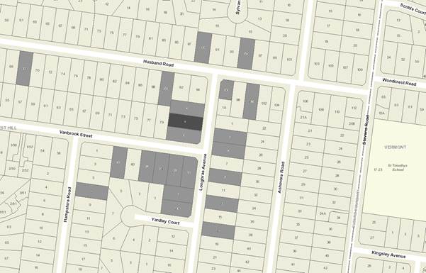
MELWAYS REFERENCE 62 G3
|
Applicant: Positive
Footprints
Zoning: General
Residential Zone Schedule 1
Overlays: N/A
Relevant
Clauses:
Clause 11 Settlement
Clause 12 Environment
and Landscape Values
Clause 15 Built
Environment and Heritage
Clause 16 Housing
Clause 21.05 Environment
Clause 21.06 Housing
Clause 22.03 Residential
Development
Clause 22.04 Tree
Conservation
Clause 32.08 General
Residential Zone Schedule 1
Clause 52.06 Car
Parking
Clause 55 Two
or More Dwellings on a Lot or Residential Buildings
Clause 65 Decision
Guidelines
Ward: Morack
|
|
|
|
|
|
Subject site
|
|
39 Objector Properties
(11 outside of map)
|
é
North
|
BACKGROUND
History
There are no previous planning
applications for the subject site.
The application was originally
lodged on 8 November 2016. Subsequent to Council’s letter seeking
additional information which was dated 29 November 2016, amended plans were
lodged on 22 May 2017 to address issues raised by Council Officers. The amended
plans removed one of the two proposed driveways, introduced articulation to the
walls of the dwellings, and reinforced the environmental sustainability of the
design of the proposed dwellings. It is these plans that form the basis of the
report below.
The Site and Surrounds
The subject site is located on the
western side of Longbrae Avenue, one house block from the intersection with
Vanbrook Street, in Forest Hill. The site is rectangular in shape with a
frontage to Longbrae Avenue of 15.24 metres, a depth of 39.93 metres, and a
total site area of 607.8sqm.
The site is occupied by a single
storey brick veneer dwelling with a tiled hip and gable roof. A separate garage
is located on the northern boundary in the rear of the site, and is accessed
via a single width crossover and driveway that extends along the northern
boundary. The dwelling is surrounded by established gardens consisting largely
of open lawn area with evergreen shrubs having a height of between 3 – 5
metres scattered around the perimeter.
In terms of topography, the site is
relatively flat, with a fall from the south to the north of approximately
400mm. A 1.83 metre wide drainage and sewerage easement extends along the rear
(western) boundary.
The surrounding properties are
residential, comprising a mix of single and double storey dwellings generally
from the 1960s-1980s set within established exotic gardens. The immediate
context comprises:
North:
· The
property at 2 Longbrae Avenue contains a single storey brick dwelling with a
hip and gable roof including eaves. The existing dwelling has a long straight
side wall constructed close to the common boundary (setback approximately 800mm
from its southern boundary). This southern wall of the dwelling contains four
habitable room windows which have outlook toward the site. The boundary is
marked by a 2.0 metre high timber paling fence.
East:
· Immediately
to the east is the Longbrae Avenue street frontage, which contains a street
tree in front of the property. On the opposite side of the street, blocks are developed
with established single storey brick veneer dwellings, which are generally
uniformly setback and contain front fencing ranging from 700mm to 1.5m in
height. Car parking structures are generally detached and located in the rear,
with a driveway located along the northern (side) boundary providing access.
South:
· The
property at 6 Longbrae Avenue is a corner allotment, and contains a single
storey brick dwelling with a hip and gable roof including eaves. The existing
dwelling is setback 1.79 metres from the common boundary to the side wall of
the dwelling, and setback 1.3m from the common boundary to the edge of the eave
line. The northern wall of the dwelling contains three habitable room windows
and a door with adjoining window which have outlook toward the site. A detached
single garage is located in the rear of the property, adjacent to the easement,
with vehicle access derived from Vanbrook Street. The boundary is marked by a
1.8 metre high timber paling fence.
West:
· To
the west, at 79 Vanbrook Street, the property is developed with a single storey
brick veneer dwelling with a hip and gable roof including eaves. The rear of
the property adjoins the subject site, and a single detached galvanised iron
garage is located on the common boundary with the subject site, accessed via a
driveway that extends along the eastern boundary of the land. A timber shed is
also located within the secluded private open space to the rear of the
dwelling. The boundary is marked by a 1.8 metre high timber paling fence.
Planning Controls
Pursuant to Clause 32.08 (General
Residential Zone Schedule 1) of the Whitehorse Planning Scheme, a planning
permit is required for the construction of two or more dwellings on a lot.
PROPOSAL
It is proposed to construct two
double storey dwellings in a lineal, one behind the other arrangement.
Dwelling 1 will face the street
(Longbrae Avenue), while Dwelling 2 will be located in the rear of the site.
A shared vehicle access arrangement
will be provided, with the proposed driveway to utilise the existing crossover
in Longbrae Avenue and extending down the northern boundary of the site.
Both dwellings include an open plan
kitchen/ living area at ground floor level and Dwelling 2 also contains a bedroom
and bathroom. The first floors of Dwelling 1 and 2 each contain two bedrooms,
shared bathroom, and a lounge area. Secluded private open space is located on
the northern side of the dwelling and has good solar access.
A 0.9 metre paling fence is
proposed along the Longbrae Avenue frontage.
The materials and colour palette
proposes lightweight cladding to the dwelling, with double glazed windows and
metal sheet roofing.
The proposed dwellings will have a
maximum overall height of 8.0 metres.
The proposed houses will both have
a minimum 8 star energy rating. The design includes passive solar design, using
windows and glazed doors for heat gain in winter and ventilation in summer,
eaves for summer shading, concrete floor for thermal mass and high levels of
insulation to the walls and roofing. Rainwater will be harvested and
reticulated for toilet flushing, and to supply laundry and garden taps. Solar
panels, ceiling fans, water efficient plumbing and appliances and energy efficient
appliances will also be included.
The development is consistent with
the guidelines for development in the Garden Suburban Precinct 6, as the
proposal will not result in the loss of any significant trees or substantial
vegetation, provides more than 30% as permeable surface (proposed to be 59%),
includes one vehicle crossover per site frontage, includes private open space
with a minimum dimension of 5 metres for each dwelling with a northern
orientation, has a front setback of 7.0 metres, is setback a minimum of 1.0
metre from the southern (side) boundary, is separated by 6.4 metres between the
two proposed dwellings, and includes articulated facades of buildings with the
use of recesses, window openings and variation in the materials and colour palette.
CONSULTATION
Public Notice
The application was advertised by
mail to the adjacent and nearby property owners and occupiers and by erecting a
notice on the front of the site. Following the advertising period, thirty nine
(39) objections were received from neighbouring and surrounding properties.
The issues raised are summarised as
follows:
Neighbourhood Character
· Building
bulk and form
· Overdevelopment
of the site
· Two
storey development
Amenity Impacts
· Overlooking
· Overshadowing
· Noise
during construction
Traffic and Car Parking
· Increased
on-street parking
· Traffic
safety impacts on the street (noise)
Landscaping
· Tree
removal
Non-planning matters
· Concerns
regarding asbestos
· Negative
impact on surrounding property values
· Set
an undesirable precedent
Consultation Forum
A Consultation Forum was held on
Tuesday, 22 August 2017. Approximately twenty three (23) objectors
attended the meeting together with the applicant, Council Officers and
Councillor Bennett.
The Chair facilitated discussions
around the themes raised in objections. The applicant provided a brief overview
and some of the key features of the application to participants. Although no
consensus was reached in terms of the issues raised, the applicant agreed to
the following:
· Extent
of overshadowing to 6 Longbrae Avenue (adjoining property to the south) to be
clarified, through the provision of overshadowing plans at a scale of 1:100
which are to show the shadow cast by the proposed development, in addition to
the extent of shadow cast by the existing boundary fence. These were provided
on 30th August 2017, and demonstrated compliance with the
requirements of ResCode.
· The
300mm trellis to be erected on the northern boundary to screen views from the
external deck to Dwelling 2 will be freestanding, and not affixed to the top of
the boundary fence.
Referrals
External
The application did not require any
external referrals under Section 55 of the Planning and Environment Act, 1987.
Internal
Planning Arborist
The plans appear to show no trees
being retained on site.
The site, landscape and drainage
plans must be amended to show the following:
· Trees
2, 3, 4, 5, 6, and 8 which are located on adjoining properties, together with
their respective TPZs and SRZs.
· No
TPZ is to be less than 2.0 metres.
A landscape plan is to be prepared
to show one large tree and three medium to small sized trees being planted
within the front setback. In addition, the plans must show shrubs and grasses
planted throughout the site. All species are to be selected from a list
provided by Council Officers.
DISCUSSION
Consistency with State and Local
Planning Policies
The State Planning
Policy Framework aims to increase the supply of housing in existing urban
areas, and to encourage well-designed infill housing which respects the
identified existing and preferred neighbourhood character, improves housing
choice, makes better use of existing infrastructure and improves energy
efficiency of housing.
The construction
of one additional dwelling on this site is consistent with State and Local
Planning Policies which encourages higher density housing development within
walking distance of shops, recreation facilities and public transport. The
proposal accords with State Planning Policies which seek to ensure housing
stock matches changing demand by widening housing choice; encourage the
development of well-designed medium-density housing that makes better use of
existing infrastructure; and that new development respects the neighbourhood
character and appropriately responds to its landscape, valued built form and
cultural context.
Clause 21.06 (Housing) identifies
three categories of ‘change’ in the municipality. The subject
site is included within a ‘natural change area’, which is
expected to ‘allow for modest housing growth and a variety of housing
types provided they achieve the preferred future neighbourhood character as
identified in Clause 22.03 – Residential Development’.
The objectives for ‘natural
change areas’ include:
· ‘Support
increased housing choice by allowing for a diversity of dwelling types, sizes
and tenures.
· Ensure
new development contributes to the preferred neighbourhood character of the precinct.
· Encourage
new development applications to include landscape guidelines that show how the
retention of existing vegetation where possible will be achieved, at the outset
of the design process.’
Under Clause 22.03 (Residential
development), strategies for ‘natural change areas’ include:
· ‘Encourage
low and medium density housing in the following forms:
o Detached houses;
o Semi-detached
dwellings, townhouses, row or terraces;
o Units or townhouses.
· Support
new medium density developments in Natural Change Areas that:
o Contribute to the
preferred neighbourhood character for the location;
o Provide a sensitive
and appropriate interface with adjoining streetscapes, buildings and
residential areas.
· Provide
a range of dwelling types, sizes and tenures, including affordable housing, in
larger developments.
· Locate
medium density housing, in the form of townhouses or units, close to transport,
activity centres and community infrastructure.
· Ensure
that the siting and design of new dwellings is respectful of surrounding
development.
· Ensure
buildings interfacing sensitive areas and uses in natural change areas are of a
scale and massing appropriate to the character and scale of their context.
· Consider
the retention of older dwellings in areas where these buildings
dominate.’
The site is included within the Garden Suburban Precinct 6. The
preferred character statement for GS6 is as follows:
“The modest, pitched roof dwelling will sit within
well-established garden settings and will not dominate the streetscape due to
consistent siting patterns and substantial planting. The rhythm of dwelling
separation will appear regular from the street, even with buildings
occasionally built to one side boundary. The streets will have spacious and
leafy feel, which is complemented by tall trees in the public and private
realm, visible from lawn areas due to the frequent lack of or low front fencing
and grass nature strips.”
The design response allows for perimeter landscaping to be provided,
and the building form is graduated in height so that the upper levels can
achieve setbacks and recession of building forms. The setbacks proposed together
with the graduation in height provides for a transition of built form to
existing abutting residential interfaces.
It is noted that a key issue raised by objectors is the introduction
of two storey form. The components of the Whitehorse Planning Scheme that seek
to manage appropriate neighbourhood character outcomes do not disregard two
storey buildings. Rather, they seek to ensure built form elements provide a
response that respects setbacks, landscape and buildings that do not dominate
in the street context. The response provided achieves a modest two storey form
that responds to these components of the neighbourhood character.
Achieving a site responsive design is further guided by the
objectives contained within the City of Whitehorse Neighbourhood Character
Study 2014, and the policy objectives of Clause 22.04 (Tree Conservation).
Clause 22.04, Tree
Conservation, seeks to encourage the retention and regeneration of significant
vegetation. The development proposes substantial in-ground landscaping
areas made available along the rear and side boundaries, and front setback to
enhance the tree coverage and landscape character.
General Residential Zone
Schedule 1
The purpose of the zone includes:
“To encourage development
that respects the neighbourhood character of the area.
To encourage a diversity of
housing types and housing growth particularly in locations offering good access
to services and transport.
To allow educational,
recreational, religious, community and a limited range of other non-residential
uses to service local community needs in appropriate locations.”
The decision guidelines for
Schedule 1 to the GRZ include:
· “Whether
the proposal provides for an appropriate built form transition to residential
properties in the Neighbourhood Residential Zone.
· Whether
the vegetation in the street setback will contribute to the preferred
neighbourhood character and the public realm.
· Whether
there is sufficient permeable space that is not encumbered by an easement to
enable the planting of canopy trees.
· Development
should provide for the retention and/or planting of trees, where these are part
of the character of the neighbourhood.”
The design response for the subject
site seeks to remove all trees from the subject site, however none of the trees
have been assessed as significant, nor do they contribute to the local
landscape character.
It is considered that the proposed
development makes adequate provision for landscaping both in the front setback
to Longbrae Avenue, and in between dwellings, and that adequate areas have been
provided on site to plant canopy trees to both soften the presentation of the
built form, and contribute to the landscape character of the area.
The proposed dwellings are
detached, with good separation at both ground floor and first floor, and
leaving sufficient space for a landscape buffer between the dwellings on the
same site, as required by the General Residential Zone Schedule 1.
Design and Built Form
The proposed development comprises
a contemporary design, however the scale and proportions of the buildings are
in keeping with the built form of developments in the area. The design of the
new dwellings does not exceed two storeys in height, and the proposed roof
forms incorporate eaves which will ensure that this new development provides a
positive interface and will not dominate the streetscape. Furthermore, building
detailing will reflect (without mimicking) the details of buildings in the area
such as the use of recesses, window openings and variations in materials and
colours.
The proposed design and siting is
consistent, subject to conditions, with the objectives and intent of
Council’s Residential Development Character Area Garden Suburban Precinct
6. In particular, the proposal retains the generous front setbacks, and
proposes to maintain a 1.2 metre setback from the southern boundary to allow
views between dwellings. Substantial landscaping opportunities have also been
incorporated throughout the site.
The proposed front setback of
Dwelling 1 is 7.0 metres from Longbrae Avenue to the front wall of the house.
The adjoining property to the south (6 Longbrae Avenue) has a front setback of
9.1 metres, while the adjoining dwelling to the north (2 Longbrae Avenue) has a
front setback of approximately 8.2 metres. In accordance with Standard B6 of
Clause 55 (ResCode), the front setback should be the average of the adjoining
properties, and therefore be 8.6m. However, the decision guidelines of Standard
B6 allow the responsible authority to consider if an alternative front setback
would be suitable, given the prevailing front setbacks in the surrounding area.
Houses located on the eastern side of Longbrae Avenue have setbacks ranging
from approximately 6.5 metres to 7.6 metres, so the proposed front setback of
7.0 metres is considered to be appropriate in the neighbourhood context.
The proposed dwellings have
sufficient space around them to be meaningfully landscaped, so that they will
sit within garden settings and will not dominate the streetscape. Tall trees in
the front setback will also assist in providing a visual break to the proposed
dwelling.
A 0.9 metre paling fence is
proposed along the Longbrae Avenue frontage, which is considered to be
appropriate to the dwelling style.
Landscaping
It is proposed to remove all
existing vegetation from the subject site. Species of trees on site, as
identified in the arborist report prepared by Tag Consulting and dated 10 March
2017, include Bird of Paradise, Chinese Elm, Photinia, Cabbage tree, and Sweet
Pittosporum. None of these species or individuals has been assessed as
significant, or contributing to local landscape character.
The street tree on Longbrae Avenue,
a 4.0 metre high Queensland Brush Box, will be unaffected by the proposed
development as the existing crossover will be utilised to service both Dwelling
1 and Dwelling 2.
Council’s Arboricultural
Assessment noted that no trees are proposed to be retained on site. It is noted
that the trees on adjoining properties, and their respective TPZs and SRZs be
shown on the development plans. Also that any landscape plan proposed should
show one large tree and three medium to small sized trees being planted within
the front setback, which would soften the appearance of the building form when
viewed from the adjoining residential street. In addition, it was requested the
landscape plans show shrubs and grasses to be planted throughout the site, with
species to be selected from a list supplied by Council.
These landscaping requirements will
meet the objectives of the Garden Suburban Precinct 6, as there will be space
provided to plant new canopy trees and substantial vegetation, footings are
located outside the root zone of established trees on adjoining properties, and
site permeability is approximately 70%. Open space areas are oriented to the
north for both Dwelling 1 and 2.
Amenity
A number of objectors raised
concerns regarding the potential impact from overlooking, overshadowing, noise
and pollution. The siting and design of the development is not considered to
give rise to any unreasonable off-site amenity impacts as follows:
· The
development achieves a ground floor setback of 1.0 metre to Dwelling 1 and 1.6
metres to Dwelling 2, and a first floor setback of 2.1 metres for Dwelling 1
and 2.6 metres to Dwelling 2. These setbacks will ensure well articulated built
forms.
· The
adjoining dwelling to the south (6 Longbrae Avenue) has north facing windows
within 3.0 metres of a boundary, and as such, the provisions at Standard B20 of
ResCode (Clause 55.04-4 North facing windows) apply. This provision
requires a formulaic setback from the boundary depending upon the height of the
dwelling. Dwelling 1, which is proposed to be constructed adjacent to the
existing dwelling at 6 Longbrae Avenue has a wall height on its southern
boundary of 5.5 metres, requiring a setback from any north facing windows of
1.0 metre increasing to 2.9 metres from the edge of each side of the window.
This setback can include land on an adjoining lot.
The ground floor plans have a
dimension of 2.8 metres between the north facing wall of 6 Longbrae Avenue, and
the southern wall of Dwelling 1. The first floor plans have a dimension of 3.8
metres between the north facing wall of 6 Longbrae Avenue, and the south facing
first floor wall of Dwelling 1. The setbacks therefore exceed the requirements.
· The
development will not cause overshadowing to its northern side, however it will
cause some shadow spill into the adjoining property to the west and to the
south. The development must therefore be tested against the measures at
Standard B21 of ResCode (Clause 55.04-5 Overshadowing open space).
At 9am on the 22 September (the date
on which the ResCode standard is measured), shadows will be cast by the
proposed development to the west (79 Vanbrook Street) In the case of the 9am
shadow, it will fall over the roof of the existing galvanised iron garage in
the rear secluded private open space, and will also fall over the driveway.
However, it will be contained within the shadow cast by the existing 1.8m high
timber paling boundary fence.
At 12pm, continuing until 3pm, some
overshadowing will occur to the adjoining property to the south (6 Longbrae
Avenue). The shadow cast will fall generally within that cast by the existing
1.8m high timber paling boundary fence, or will extend over the eaves and roof
of the northern side of the dwelling.
The property at 6 Longbrae Avenue
will receive a minimum of five hours of sunlight between 9am and 3pm on 22
September its private open space.
The extent of shadows cast is
therefore considered to be acceptable.
· With
regard to overlooking, the elevation plans are not clear on whether or not
obscure glazing is proposed to be used for first floor windows, in particular
those on the northern and southern elevations. This can be required by a
condition on planning permit, to ensure compliance with Standard B22 of ResCode
(Clause 55.04-6 Overlooking). The windows on the western elevation appear to
have sill heights of 1.7 metres above finished floor levels to ensure there
will be no unreasonable overlooking however this can also be clarified through
planning permit condition.
In relation to the north facing deck
in the secluded private open space of Dwelling 2, some concern was raised in
the Consultation Forum with regard to affixing 300mm trellis on top of the
existing 2.0 metre high common boundary fence. Given that the existing fence is
already high, the addition of trellis will create a large structure. The rear
of the dwelling at 2 Longbrae Avenue contains large shrubs/ small trees which
would screen views in the short term, but cannot be relied upon in the long
term. Therefore, in lieu of the trellis, it is considered appropriate to
require screen planting along the northern boundary which will serve the
purpose of both softening the presentation of the building, and screening any
views from the timber deck into the adjoining secluded private open space. This
will be required by planning permit condition.
· Residential
noise associated with dwelling is considered to be normal and reasonable within
the area, and the proposed setbacks will provide further mitigation of residential
noise.
· Some
noise and other off site impacts are inevitable when any construction occurs.
The developer will be required to meet relevant Building and EPA regulations
regarding construction practices to ensure these impacts are mitigated, and
that pedestrian access is maintained. A Construction Management Plan is not
warranted for the proposed development of two detached dwellings associated
with the subject proposal.
Clause 55 (ResCode)
The proposed development has been
fully assessed against and is considered, subject to conditions, to satisfy the
relevant standards and objectives of Clause 55 (ResCode) of the Whitehorse
Planning Scheme.
Car Parking
Clause 52.06 (Car Parking) is a
relevant consideration of this application and the objectors have also raised
concerns regarding potential impacts on the availability of car parking within
the area.
The purpose of Clause 52.06 includes:
· ‘To
ensure the provision of an appropriate number of car parking spaces having
regard to the demand likely to be generated, the activities on the land and the
nature of the locality.
· To
support sustainable transport alternatives to the motor car.
· To
promote the efficient use of car parking spaces through the consolidation of
car parking facilities.’
Dwelling 1 (two bedrooms) is
proposed to be provided with a single garage integrated into the ground floor
design. Dwelling 2 (three bedrooms) is proposed to be provided with a covered
car parking space adjacent to the northern boundary, and an open at grade car
parking space located on the eastern side of the dwelling. This is fully
compliant with the requirements.
It is proposed to utilise the
existing crossover to provide vehicle access for both Dwelling 1 and 2. This
will ensure that the loss of front garden space is minimised, that car parking
structures do not dominate the street frontage, and that on street parking
spaces are retained as the status quo.
Bicycle parking is not required to
be provided in association with the proposed dwellings, however any bicycles
could be stored within the dwelling, or within the garage to Dwelling 1 or the
rear yard of both dwellings.
In order to ensure compliance with
Design Standard 1 of Clause 52.06 Car Parking, a condition will be included on
any planning permit issued, requiring that a notation on the
site plan indicating a corner splay or area at least 50 per cent clear of
visual obstructions extending at least 2 metres along the frontage road from
the edge of the proposed driveway and 2.5 metres along the exit lane from the
frontage, to provide a clear view of pedestrians on the footpath of the
frontage road.
Objectors Concerns not
Previously Addressed
· Asbestos issues
Asbestos is not
dealt with under the planning provisions.
It is the
responsibility of the property owner and/or demolisher to use a licensed
asbestos removalist to deal with any asbestos products on the land in a safe
manner. There are a number of laws, compliance codes and guidance
documents that outline the obligations of a person removing asbestos, including
Occupational Health and Safety Act 2004, and Occupational Health and
Safety Regulations 2007. Worksafe also issues Compliance Codes to provide
practical guidance to those who have duties or obligations under the OHS Act.
· Negative
impact on surrounding property values
The Victorian Civil and
Adminstrative Tribunal and its predecessors have generally found subjective
claims that a proposal will reduce property values are difficult, if not
impossible to gauge and of no assistance to the determination of a planning
permit application. It is considered the impacts of a proposal are best
assessed through an assessment of the amenity implications rather than any
impacts on property values.
· Set an undesirable precedent
Each planning
permit application is decided on its own individual merits, and against the
relevant planning policies and provisions. It cannot be considered against
precedent.
CONCLUSION
The proposal for construction of
two detached double storey dwellings is an acceptable response that satisfies
the relevant provisions contained within the Whitehorse Planning Scheme,
including the State and Local Planning Policies, the General Residential Zone
Schedule 1, and Clause 55 (ResCode).
The proposed development form,
siting and overall design is considered to be acceptable and will integrate
well with the existing built form and character.
The application has been
advertised, and the concerns raised by objectors have been suitably addressed
in this report.
It is therefore considered that the
application should be approved.
Attachment
1 Advertised
Plans ⇨ 
2 Shadow Diagrams
⇨
Ordinary Council Meeting 16
October 2017
9.1.2 34-36
Prospect Street, BOX HILL (CP 161378A 5)
FILE NUMBER: WH/2016/1156
ATTACHMENT
SUMMARY
This application proposes the
use of the land for accommodation (dwellings), buildings and works for the
construction of a thirty (30) storey mixed-use building, comprising retail
premises, office, and dwellings, with basement car parking, and associated
reduction in the provision of car parking spaces, and waiver of loading and
unloading of vehicle requirements.
The application was advertised,
and a total of four (4) objections were received. The objections raised issues
with overlooking, overshadowing, traffic congestion and car parking,
residential use of land in a designated office area, overdevelopment of the
site, and oversupply of residential units in Box Hill.
This report assesses the
application against the relevant provisions of the Whitehorse Planning Scheme,
as well as the objector concerns. The statutory carparking rate required
by the planning scheme is met by the proposal with the exception of the rate
for retail premises which is an empirical assessment to the satisfaction of the
Responsible Authority. Council officers are satisfied by the number of retail
spaces provided. It is recommended that the application be supported,
subject to conditions.
|
RECOMMENDATION
That Council:
A Being the Responsible Authority, having
caused Application WH/2016/1156 for 34-36 Prospect Street, BOX HILL (CP
161378A 5) to be advertised and having received and noted the objections is
of the opinion that the granting of a Planning Permit for the Use of the land
for accommodation (dwellings), buildings and works for the construction of a
thirty (30) storey mixed use building, comprising retail premises, office,
and dwellings, with basement car parking, and associated reduction in the
provision of car parking spaces, is acceptable and should not unreasonably
impact the amenity of adjacent properties.
B Issue a Notice of Decision to Grant a
Permit under the Whitehorse Planning Scheme to the land described as 34-36
Prospect Street, BOX HILL (CP 161378A 5) for the Use of the land for
accommodation (dwellings), buildings and works for the construction of a
thirty (30) storey mixed use building, comprising retail premises, office,
and dwellings, with basement car parking, and associated reduction in the
provision of car parking spaces, subject to the following conditions:
1. Before
the use and development starts, amended plans and documents (two full size
copies and one A3 size copy) must be submitted to and approved by the
Responsible Authority. The plans must be drawn to scale generally in
accordance with plans dated 20 December 2016 and 16 March 2017 prepared by
Taouk Architects, but modified to show:
a) A
minimum of seven (7) apartments to be clearly designated as being for social/
affordable housing.
b) All
doors that open out onto Fairbank Lane over the carriageway easement must
open 180 degree flat against the building wall.
c) Corridor
widths providing access from lift lobby to the main corridor must be a
minimum of 1.8 metres in width.
d) Provision
of publically accessible artwork in the commercial and residential lobbies,
in accordance with Condition 22.
e) All
residential balconies must have a minimum area of 8 square metres
uninterrupted by any plant or equipment, such as air-conditioner external
units.
f) Provision
of play equipment or playable elements for children, such as sculpture or
seating elements in communal areas.
g) Notation
that no part of the building is to encroach into the road reserve.
h) The
provision and location of two showers and associated change rooms to be
provided for staff of the various uses.
i) Provision
of a minimum of five (5) dedicated motorcycle parking spaces within the
basement.
j) Demonstrate
that a minimum 4.0 metre height clearance is provided at the entrance to the
car park at the street level and the canopy above the entrance.
k) The
retail premises 1 south facing wall to Prospect Street on the Ground Floor
Plan is to be entirely glazed, to avoid the perception of an unsafe space at
the entrance to the services area.
l) The
office space 1 south facing wall to Prospect Street on the Level 1 Floor Plan
is to be entirely glazed, to avoid the perception of an unsafe space in the
south-western corner.
m) The provision
and location of a minimum of two car share spaces within the basement to be
made available to building residents, staff, and the public.
n) Provision
of some of the bicycle parking hoops in front of the entrances to the retail
areas.
o) Alterations
to plans to show the requirements of the approved Parking Management Plan and
Green Travel plan, where relevant.
p) A
detailed schedule and samples of all external cladding materials, colours and
finishes, including fine grain details of façade treatments such as
door and window opening at all levels but particularly at the ground and
first floor levels which interface with Prospect Street and Fairbank Lane.
Consideration should be given to energy efficiency properties, durability and
maintenance requirements of selected materials, colours and finishes.
q) Specification
of glazing materials to be used on all external walls, including details
demonstrating that they will not reflect unreasonable glare when viewed from
any nearby road network, to the satisfaction of the Responsible Authority.
r) Development
plans to reflect all sustainability features indicated in the updated
Sustainability Management Plan required by Condition 19. Where features
cannot be visually shown, include a notes table providing details of the
requirements (i.e. energy and water efficiency ratings for heating/ cooling
systems and plumbing fittings and fixtures, etc).
s) The
following reports to be amended as required will form part of the endorsed
documentation:
i. Landscape
Plan in accordance with Condition 9
ii. Landscaping
Maintenance Plan in accordance with Condition 10
iii. Amended
Sustainability Management Plan in accordance with Condition 19
iv. Art
Strategy in accordance with Condition 22
v. Lighting
Strategy in accordance with Condition 23
vi. Parking
Management Plan in accordance with Condition 27
vii. Traffic
Impact Assessment in accordance with Condition 29
viii. Green Travel
Plan in accordance with Condition 30
ix. Waste
Management Plan in accordance with Condition 32
x. Construction
Management Plan in accordance with Condition 33
xi. Detailed
Engineering Design Drawings for treatment of land within Fairbank Lane in
accordance with Condition 44
xii. Amended
Acoustic Report in accordance with Condition 58
All of
the above must be to the satisfaction of the Responsible Authority. Once
approved these plans and documents become the endorsed plans of the permit.
2. The
layout and operation of the site and the size, design and location of the
buildings and works permitted must always accord with the endorsed plans and documents,
and must not be altered or modified without the further written consent of
the Responsible Authority.
3. The
uses as approved, must not commence until all of the buildings and works and
landscaping hereby approved are completed to the satisfaction of the
Responsible Authority.
4. Notwithstanding
signage that can be displayed as of right or as approved by a planning
permit, any transparent glazing at facades of the ground floor, and Level 1
must be retained without visual obstruction, to the satisfaction of the
Responsible Authority.
5. The
communal areas, including the gardens, swimming pool, and recreational areas
must be available for use by all residents and employees of the particular
building.
6. This Planning Permit does not and should not be taken as
authorizing the occupation of or carrying out of works upon or over land or
airspace not under the ownership or control of the permit holder. The permit
holder must satisfy itself that it holds the permissions or interests
necessary to carry out the use and/or development.
Affordable Housing
7. A
minimum of seven (7) dwellings within the development are to be donated to a
registered housing association / provider for the provision of social or
affordable housing in accordance with the requirements of the Housing Act 1983 or other applicable legislation as amended
from time to time.
8. Prior
to the commencement of buildings and works the owner of the land must enter
into an agreement with the Responsible Authority under Section 173 of the
Planning and Environment Act 1987 requiring:
a) Upon
registration of the plan of subdivision for the development, the title to
seven (7) dwellings is to be donated to a registered housing association/
provider to the satisfaction of the Responsible Authority to be used for the
purpose of providing affordable housing;
b) The
dwellings are to be made available to rent to a tenant who (unless with the
further written consent of the Responsible Authority):
i. Would qualify
as an eligible tenant under the Victorian Community Housing Federation
criteria (or equivalent).
c) The
dwelling must be made available to rent at a rate that is at least 25 per
cent below the market value rent (as determined by a licensed valuer every
three years).
d) That
all dwellings will at all times be managed and tenanted in accordance with
the relevant performance standards set pursuant to Section 94 of the Housing
Act 1983 (Vic) or other applicable legislation, as amended from time to time.
e) The cost or preparing and registering the agreement is to be paid
by the permit holder.
Landscaping
9. No
building or works are to be commenced until a landscape plan prepared by a
suitably qualified and experienced person or firm has been submitted to and
endorsed by the Responsible Authority. This plan when endorsed will form part
of this permit. This plan shall show:
a) Details
of all street frontage features and footpath areas from the building
façade to the kerbs of Prospect Street. The design and materials must
be consistent with the Box Hill Urban Landscape Design Guidelines Urban Core
Treatment, to the satisfaction of the Responsible Authority.
b) Details
of all proposed landscaping within the communal area, road reserves,
pedestrian link and public open spaces.
c) Nomination
of all proposed services eg street lights and all existing infrastructure
services, street furniture, bins etc.
d) Details
of all containerized planting infrastructure.
e) Play
equipment or playable elements such as sculptures for children residing or
visiting the building.
f) Demonstration
that the garden areas are capable of holding the deep root zone of the tree
sizes shown, with details for the protection of trees during windy weather
conditions.
g) A
planting schedule of all proposed vegetation (trees, shrubs and ground covers)
which includes botanical names, common names, pot size, mature size and total
quantities of each plant.
All of the above must be to the satisfaction of the Responsible
Authority.
Once approved these plans become the endorsed plans of this
permit.
10. Prior
to the commencement of the development, a Landscaping Maintenance Plan,
prepared by a suitably qualified consultant, must be submitted to the
Responsible Authority. The landscaping maintenance plan must include, but is
not limited to:
a) Details
in relation to the transportation of substrates and proposed species for all
proposed garden or landscaping areas.
b) Irrigation
system for street trees and street level garden beds, including details of
frequency and water delivery method.
c) Details
of the ongoing maintenance procedures to ensure that the garden areas remain
healthy and well maintained to the satisfaction of the Responsible Authority.
This must include:
i. Irrigation
frequency and delivery method;
ii. Drainage;
iii. Pruning and mulching.
All of
the above must be to the satisfaction of the Responsible Authority.
Once approved these plans become the endorsed plans of this
permit.
11. The garden
and recreation areas shown on the endorsed plan and schedule must only be
used as garden and recreational areas and must be maintained in a proper,
healthy and orderly condition at all times to the satisfaction of the
Responsible Authority. Should any tree or plant be removed or destroyed it
must be replaced by a similar tree or plant of similar size and variety.
Landscaping in accordance with the approved plan and schedule shall be
completed before the building is occupied.
12. Prior to the
occupation of the approved building, the road reserve between the subject
site and the kerb along the Prospect Street must be constructed and laid out
in accordance with the endorsed plans to the satisfaction of the Responsible
Authority. The design and materials must be consistent with the Box Hill
Urban Landscape Design Guidelines Urban Core Treatment, to the satisfaction
of the Responsible Authority.
13. No street tree may be removed without the prior written consent of
the Responsible Authority.
Wind Report
14. The
recommendations of the Wind Impact Assessment, prepared by Vipac Engineers
and Scientists dated 24 January 2017 must be implemented such that:
a) There
is no cost to the Responsible Authority.
b) There
is no reliance on the provision of street trees for wind mitigation.
c) There
is no reliance on the provision of vertical baffles on public land, except
where all appropriate approvals have been obtained from all relevant
authorities and land managers and approval also granted by the Responsible
Authority.
d) Consent
and the appropriate approvals must be obtained from Whitehorse City Council
for all wind amelioration features that protrude into or over council owned
or managed land, including the road reserve.
Building
Services
15. The
development must provide the capacity for television signal distribution to
each dwelling and any satellite dish, antenna or similar structure must be
designed and located at a single point to the satisfaction of the Responsible
Authority.
16. All building
plant and equipment on the roofs, balcony areas, common areas, public
thoroughfares is to be concealed to the satisfaction of the Responsible
Authority. Noise emitting plant equipment such as air conditioners, must be
shielded with acoustic screening to prevent the transmission of noise having
detrimental amenity impacts. The construction of any additional plant,
machinery or other equipment, including but not limited to all service
structures, down pipes, aerials, satellite dishes, telecommunication
facilities, air-conditions, equipment, ducts, flues, all exhausts including
car parking and communication equipment must include appropriate screening
measures to the satisfaction of the Responsible Authority.
17. All
mechanical exhaust systems for the car park hereby approved must be located
and sound attenuated to prevent noise and general nuisance to the occupants
of the surrounding properties, to the satisfaction of the Responsible
Authority.
18. Mail boxes
are to be accessible for deliveries between the hours of 6am to 6pm Monday to
Friday.
Sustainability Management
Plan
19. Prior to the
commencement of any buildings or works, an amended Sustainability Management
Plan (SMP) must be submitted to and approved by the Responsible Authority.
Once
submitted and approved to the satisfaction of the Responsible Authority, the
Sustainability Management Plan will form part of the endorsed plans under
this permit.
The
requirements of the Sustainability Management Plan must be demonstrated on
the plans and elevations submitted for endorsement, and the requirements of
this plan must be implemented by the building manager, owners and occupiers
of the site when constructing and fitting out the residential building, and
for the duration of the building’s operation in accordance with this
permit, to the satisfaction of the Responsible Authority.
20. Prior to the
occupation of the building approved under this permit, a report from the
author of the SMP, approved pursuant to this permit, or similarly qualified
person or company, must be submitted to the Responsible Authority. The report
must be to the satisfaction of the Responsible Authority and must confirm
that all measures specified in the SMP have been implemented in accordance
with the approved plan.
21. All works
must be undertaken in accordance with the endorsed SMP to the satisfaction of
the Responsible Authority, and the approved uses and building must operate in
accordance with this Plan, to the satisfaction of the Responsible Authority.
No alterations to the SMP may occur without the prior written consent of the
Responsible Authority.
Art Strategy
22. Prior to the
occupation of all the tenancies and dwellings of this development, an Art
Strategy must be prepared to the satisfaction of the Responsible Authority.
The Art Strategy must provide details of a process to allow review of the
conceptual design of artwork by Council representatives, prior to the
installation of the artwork, in order to ensure that the artwork achieves the
following objectives:
a) To
activate the facades of the building and facilitate pedestrian activity at
the interfaces;
b) To be
constructed in a safe and structurally sound manner and of durable and
appropriate materials; and
c) To
display appropriate content.
d) To be
of high quality and demonstrate artistic excellence.
The
permit holder must convene a Review Committee comprising (but not limited to)
an Arts Officer and a Planning Officer from Whitehorse City Council, a
building surveyor/ structural engineer, and representatives of the land
owner, artist and architect. The Review Committee must review the artwork at
concept stage to ensure it will comply with the objectives listed above. The
final artwork must be consistent with Review Committee’s
recommendations, and must also achieve structural certification by a suitably
qualified structural engineer as appropriate.
The
artwork must be installed and maintained in accordance with the outcomes of
the Artwork Strategy, to the satisfaction of the Responsible Authority.
Lighting Strategy
23. Prior to the
commencement of the development, a Lighting Strategy must be prepared to the
satisfaction of the Responsible Authority. The Lighting Strategy must provide
details of proposed lighting of Prospect Street, and Fairbank Lane, and must
be prepared in accordance with the Safer Design Guidelines for Victoria,
Department of Sustainability and Environment, June 2005, to the satisfaction
of the Responsible Authority.
All
external lights must be of a limited intensity and must ensure no
unreasonable nuisance is caused to surrounding road network, adjoining
properties or nearby residents.
This lighting must be maintained and operated for the life of the
building to the satisfaction of the Responsible Authority.
Car Parking and Traffic
24. The car
parking areas and accessways as shown on the endorsed plans shall be formed
to such levels so that they may be used in accordance with the plan, and
shall be properly constructed, surfaced, drained and line-marked (where
applicable) to the satisfaction of the Responsible Authority.
25. The car park
and driveways shall be maintained to the satisfaction of the Responsible
Authority.
26. The nature
strip must be reinstated where any existing vehicle crossover is redundant,
to the satisfaction of the Responsible Authority.
27. Prior to the
commencement of buildings or works on the land, a Parking Management Plan,
detailing how car and bicycle parking areas, accessways and loading bays will
be allocated and managed, must be submitted to and approved by Council.
This plan is to be to the satisfaction of the Responsible
Authority and must include, but is not limited to, the following:
a) Provision
of a minimum of 184 car parking spaces.
b) Allocation
of spaces generally in accordance with the Traffic Impact Assessment by
Traffix Group dated November 2016.
c) Allocation
of all parking spaces (except short term, visitor and accessible and
car-share spaces) to individual dwellings and tenancies and commercial uses.
Each space within any tandem parking bays must be allocated to the same unit/
commercial tenancy.
d) Details
of car share, accessible (disabled) or motorcycle parking spaces to be
nominated within the basement car parking areas.
e) Details
of the signing and line marking of parking spaces.
f) Details
of how access to the proposed parking spaces will be secured for residential
and visitor use.
g) Detail
any access controls to the parking area, such as boom gates which shall take
into account the required queue length required as per section 3.4 of
AS2890.1.
h) Allocation
of a short term visitor drop off/ pick up/ taxi zone and details as to how
this space will be managed to allow access and advise residents and customers
as to its location.
i) Pedestrian
access and movement within the car parking areas, including strategies to
minimize the potential for conflict between pedestrians and vehicles. This may
include line marking such as hatched shared areas, directional signs and/or
physical barriers.
j) Allocation
of bicycle spaces to tenancies and visitors.
k) Provision
of some of the bicycle parking hoops in front of the entrances to the retail
areas, and gymnasium.
l) Bicycle
parking facilities are to be provided in accordance with the Australian
Standard AS2890.3:2015, Bicycle Parking Facilities are required to include a
minimum of 20% of ground level (horizontal) Bicycle Parking Devices (BPD) in
any bicycle parking facility. This is to provide for those riders unable to
lift a bicycle to a hanging BPD and for parking of non-standard bicycles.
m) Locations and
details of bicycle parking signs in accordance with Clause 52.34-5.
n) Line
marking of car parking spaces.
o) Details
of how access to car spaces, accessible (disabled) car spaces and bicycle
spaces will be achieved by visitors (i.e. an intercom) and how parking will
be secured.
p) Signage
for car and bicycle parking spaces.
q) Details
of the car share scheme.
r) Details
of how access to the waste collection area will be achieved by waste
collection vehicles (ie an intercom) and how these will be secured.
s) How the
car park will be managed to ensure that all vehicles exit the site in a
forwards direction.
t) Details
of signage or alternative measures to ensure that waste vehicles exit the
site in a forwards direction.
u) STOP/
GIVE WAY Controls are to be provided at cross intersections within the car
park, particularly at intersections with ramps where there is no control.
v) Centre
lines to be provided along curved sections of the access ramp to guide
motorists and keep vehicles to the left of the ramp.
w) Details of
the management of the shared office/ visitor spaces and details of the
enforcement of car parking allocations.
Once
submitted to and approved by the Responsible Authority the Parking Management
Plan will form part of the documents endorsed as part of this permit.
28. The proposed
ramp grade from the property line is to be a maximum of 1:10 for the first 5
metres as required by Clause 52.06-8 of the Whitehorse Planning Scheme, and
appropriately transition beyond this in accordance with AS2890.1, and/or
2890.2 for commercial vehicles.
29. Prior to the
commencement of the development and/or uses a detailed Traffic Impact
Assessment must be provided to the satisfaction of the Responsible Authority,
assessing the impact of the traffic associated with the development on:
a) Fairbank
Lane, Young Street, Prospect Street, Elgar Road, and Whitehorse Road;
b) The
intersections of:
i. Young
Street and Prospect Street
ii. Prospect
Street and Whitehorse Road
iii. Prospect
Street and Elgar Road
iv. Whitehorse
Road and Nelson Road
c) Investigate
in detail potential options to alleviate the traffic impacts of the
development to the local road network and to maintain pedestrian and cyclist
priority.
Green
Travel Plan
30. Prior to the
commencement of any buildings or works, evidence of what implementation
measures are required as contained within the Green Travel Plan, prepared by
Frater and dated 26 May 2017, and how they are to be implemented must be
provided to the satisfaction of the Responsible Authority. .
Once submitted to and approved by the Responsible Authority, the
Green Travel Plan will form part of the documents endorsed as part of this
permit.
The
requirements of this plan must be implemented by the building manager, owners
and occupiers of the site for the duration of the building’s operation
in accordance with this permit, to the satisfaction of the Responsible
Authority.
Car Share
31. A minimum of
two car-share spaces must be provided and retained on site unless otherwise
agreed in writing by the Responsible Authority. The share cars must be made
available to building residents, staff, and the public at all times. The
share cars must use fuel efficient technology. Evidence to show that a car
share agreement has been entered into must be provided to the satisfaction of
the Responsible Authority prior to occupation of the building.
Waste
Management Plan
32. Prior to the
commencement of buildings and works, the Waste Management Plan prepared by
Leigh Design and dated 21 November 2016, must be amended and submitted for
approval to the satisfaction of the Responsible Authority. The Waste
Management Plan must include:
a) The
collection vehicle must exit the development onto Fairbank Lane in an
easterly direction.
b) Allocation
of space for:
i. Bin
lifting equipment.
ii. Show
details/ locations to house this equipment.
iii. Bin washing
facilities with details/ locations/ area to house this equipment.
iv. Balers for
cardboard and soft plastic.
v. Electronic
waste disposal.
vi. Details of
how these materials will be stored/ removed from the site.
vii. Liquid waste and
charitable materials. Reference to how these materials will be handled from
within the development.
c) The
waste configuration of the development amended to implement the above waste
components/ facilities to match the scale of the development and the variety
of tenancies.
The
requirements and outcomes of the Waste Management Plan must be demonstrated
on the plans and elevations submitted for endorsement.
Once
submitted to and approved by the Responsible Authority, the Waste Management
Plan will form part of the documents endorsed as part of this permit.
The
requirements of the Waste Management Plan must be implemented by the building
manager, owners and occupiers of the site for the duration of the
building’s operation in accordance with this permit, to the
satisfaction of the Responsible Authority.
Construction
Management Plan
33. Prior to the
commencement of buildings and works on the land, a Construction Management
Plan (CMP), detailing how the owner will manage the environmental and
construction issues associated with the development, must be submitted to and
approved by Council.
The
Construction Management Plan must be prepared and managed by a suitably qualified
person who is experienced in preparing Construction Management Plans.
This
plan is to be to the satisfaction of the Responsible Authority and must be
prepared in accordance with the City of Whitehorse Construction Management
Plan Guidelines.
The CMP must
address; any demolition, bulk excavation, management of the construction
site, land disturbance, hours of construction, noise, control of dust, public
safety, traffic management, construction vehicle road routes, soiling and
cleaning of roadways, discharge of any polluted water, security fencing,
disposal of site waste and any potentially contaminated materials, location
of site offices, redirection of any above or underground services, and site
security lighting.
The CMP
must include suitable washing facilities are to be provided and utilized on
site for the cleaning of all construction vehicles prior to them exiting the
designated property so as to prevent any grease, oil, mud, clay or other
substances to fall or run off a vehicle onto a road, or into any drain under
the road.
Once
submitted to and approved by the Responsible Authority the Construction
Management Plan will form part of the documents endorsed as part of this
planning permit.
When approved the Construction Management Plan will form part of
this permit and must be complied with, to the satisfaction of the Responsible
Authority, to the extent that this is in the control of the owner of the
land. The owner of the land is to be responsible for all costs associated
with the works to be undertaken in accordance with the requirements of the
Construction Management Plan.
Alterations/
Reinstatement of Assets
34. The
developer/ contractor will be required to submit a Report regarding any
pre-existing damage to Council assets (Dilapidation Report), prior to the
Asset Protection Permit being issued and the Protection Work Notice is signed
off (if required). Please note that this Report will have to show all of the
Council assets adjoining to the property boundary, and will be based on the
approved access routes, pending on the approved Traffic Management Plan.
35. If any works
are to be undertaken in the road reserve related to the project, the
applicant is required to obtain the Consent to Undertake Works in the Road
Reserve (Road Opening Permit) for any new, altered or deleted vehicle
crossing, water or drain tapping or other opening within a road reserve or
laneway. Please note that this is a separate process to the Asset Protection
Permit.
36. If an damage
to Council trees occurs during the building works, full amenity of the trees
will be charged to the applicant. If any trees have to be removed as a part
of this project, amenity value of the trees has to be paid in full to the
Council ParksWide Department prior to the commencement of works.
Drainage
and Assets
37. Council’s
existing stormwater pipe and pits within Fairbank Lane must be protected at
all times. Any proposal to alter the Council drainage assets in any way must
be submitted to Council for approval and if approved by Council be undertaken
at the expense of the applicant.
38. All stormwater
drains must be connected to a point of discharge to the satisfaction of the
Responsible Authority.
39. Stormwater
connection to the nominated point of discharge and stormwater on-site
detention (if required) must be completed and approved to the satisfaction of
the Responsible Authority prior to the occupation of the buildings.
40. Detailed
civil plans and computations for stormwater on-site detention (if required)
and connection to the legal point of discharge must be prepared by a
registered consulting engineer (who is listed on the Engineers Australia
National Professional Engineer Register) and submitted for approval by the
Responsible Authority prior to the commencement of any works. Dual
certification by a registered consulting engineer (who is listed on the
Engineers Australia National Professional Engineer Register) for design of
the on-site detention must be provided to Council prior to the approval of
the civil plan.
41. As
constructed civil drawings that are computer drafted are to be provided to
Council after the completion of civil works prior to the occupation of the
building.
42. Stormwater
that could adversely affect any adjacent land shall not be discharged from
the subject site onto the surface of the adjacent land.
43. The Applicant/
Owner shall be responsible to meet all costs associated with reinstatement
and/or alterations to Council or other Public Authority assets deemed
necessary by such Authorities as a result of the development. The Applicant/
Owner shall be responsible to obtain an “Asset Protection Permit”
from Council at least 7 days prior to the commencement of any works on the
land and obtain prior specific written approval for any works involving the
alteration of Council and other Public Authority assets.
44. Prior to the
commencement of any works, detailed plans and specifications for the
reconstruction of Fairbank Lane shall be submitted to and approved by the
Responsible Authority. The plans must show existing and proposed works
including surface and underground drainage, pavement and footpath details,
concrete kerbs and channels and street lighting. The reconstruction of
Fairbank Lane must begin at Young Street and be constructed for the total
length of the subject property’s northern boundary.
45. Any
obstructions within the right of carriageway and/or laneway must permit
vehicles and/or articulated vehicles to travel unimpeded safely through the
rear laneway.
Amenity
46. The amenity
of the area shall not be detrimentally affected by the uses or development
allowed by this Permit through:
a) Transportation
of materials, goods or commodities to or from the land,
b) Appearance
of any building, works or materials;
c) Emission
of noise, artificial light, vibration, smell, fumes, smoke, vapour, steam,
soot, ash, dust, waste water, waste products, grit or oil.
d) Presence
of vermin, or
e) In any
other way.
To the satisfaction of the Responsible Authority.
47. The
development and use of the site must not cause nuisance or be detrimental to
the amenity of the neighbourhood by the emission of noise. In this regard the
emission of noise must comply with the provisions of the Environment
Protection Act 1970 (as amended) and the policies of the Environment
Protection Authority.
48. The
commercial use and development of the site shall be so ordered and maintained
so it will not prejudicially affect the amenity of the locality by reason of
appearance to the satisfaction of the Responsible Authority.
49. All external
lights associated with the commercial use and development of the site allow
by this Permit must be of a limited intensity to ensure no adjoining or
nearby residents and must be provided with appropriate baffles, so that no
direct light or glare is emitted outside the site to the satisfaction of the
Responsible Authority.
50. The
deliveries to the commercial tenancies must occur between the following
hours:
a) 7:00am
to 10:00pm Monday to Saturday
b) 9:00am
to 10:00pm Sundays and Public Holidays
Unless
with the further written consent of the Responsible Authority.
Glazing
51. Glazing
materials used on all external walls must be of a type that does not reflect
more than 20% of visible light when measured at an angle of 90 degrees to the
glass surface, to the satisfaction of the Responsible Authority.
Mechanical Exhaust Systems
52. All
mechanical exhaust systems for the car park hereby approved must be located
and sound attenuated to prevent noise and general nuisance to the occupants
of the surrounding properties, to the satisfaction of the Responsible
Authority.
Loading/
unloading
53. The loading
and unloading of goods from vehicles shall only be carried out within the
boundaries of the site.
Signage
Strategy
54. Prior to the
occupation of the development, a Signage Strategy shall be submitted to and
approved by the Responsible Authority. The strategy shall include details on
signage ‘zones’ and typology on the building facades including
maximum dimensions for future signage planning applications. Details are to
include wayfinding and business identification signage.
Disability
Access
55. Prior to the
commencement of development, excluding demolition, bulk excavation and site
preparation works, a detailed report on the compliance with disability access
shall be undertaken to the satisfaction of the Responsible Authority.
Public
Realm
56. Prior to any
works, design plans and specifications of the civil works within the site
associated with the development are to be prepared by a registered consulting
engineer (who is listed on the Engineers Australia National Professional
Engineer Register), and submitted to the Responsible Authority. Certification
by the consulting engineer that the civil works have been completed in
accordance with the design plans and specifications must be provided to the
Responsible Authority.
57. Prior to the
commencement of any works the owner of the land shall enter into an agreement
with the City of Whitehorse which will indemnify Council against any loss or
damage it may incur as a result of any proposed buildings and works
constructed on or over Council owned land.
Acoustic
Treatment
58. Prior to the
commencement of the development, excluding demolition, bulk excavation and
site preparation works a report generally in accordance with that prepared by
Acoustic Logic must be submitted to and be to the satisfaction of the
Responsible Authority documenting acoustic mitigation measures to be
implemented in the building to achieve compliance with the Australian
Standards.
59. Prior to the
occupation of the development, a letter of confirmation from a suitably
qualified Acoustic Consultant must be submitted for approval by the
Responsible Authority to certify that the development is designed and
constructed in accordance with the Acoustic Treatment Plan to ensure that
noise measured in the proposed dwellings and existing residential dwellings
surrounding the subject site does not exceed the levels set out under the
Australian Standard.
Expiry
60. This permit
will expire if one of the following circumstances applies:
a) The
development is not commenced within three (3) years from the date of issue of
this permit;
b) The
development is not completed within seven (7) years from the date of this
permit.
The Responsible Authority
may extend the periods referred to if a request is made in writing in
accordance with Section 69 of the Planning and Environment Act 1987.
PERMIT NOTES
Affordable
Housing
A. Prior to the certification of the plan of
subdivision, the owner of the dwellings that are nominated as affordable or
social housing must enter into an agreement with the Responsible Authority
under Section 173 of the Planning and Environment Act 1987 requiring:
a) The dwellings are to be used for the purpose
of providing social or affordable housing;
b) Unless with the further written consent of
the Responsible Authority, the dwellings are to be made available to rent to
a tenant who:
i. Would qualify as an eligible tenant
under the Victorian Community Housing Federation criteria (or equivalent).
c) Will at all times be managed and tenanted in
accordance with the relevant performance standards set pursuant to Section 94
of the Housing Act 1983 (Vic) or other applicable legislation, as amended
from time to time.
d) The
cost or preparing and registering the agreement is to be paid by the permit
holder.
Engineering and Assets
B. Soil erosion control measures must be adopted
at all times to the satisfaction of the Relevant Authority during the
construction stages of the development. Site controls and erosion
minimization techniques are to be in accordance with the EPA (Environment
Protection Authority) Victoria “Environmental Guidelines for Major
Construction Sites”. The works during and after construction must
comply with the above guidelines and in potentially high erosion areas a
detailed plan may be required to indicate proposed measures and methodology.
C. The property owner/ builder is to obtain the
relevant permits and consents from Council in relation to asset protection,
drainage works in easements and works in the road reserve prior to the
commencement of any works.
D. All stormwater drainage within the
development site and associated with the building(s)(except for an on-site
detention system and connection to the nominated legal point of discharge
within the site) must be approved and completed to the satisfaction of the
Building Surveyor prior to the occupation of the building(s), in accordance
with the provisions of the Building Regulations (2006) section 610.
E. The surface treatment and design of all
crossovers and driveways shall be of materials submitted to and approved by
the Responsible Authority and must be constructed in accordance with the
submitted details.
F. No alteration to existing interface levels
will be permitted other than to maintain or introduce adequate and consistent
road reserve crossfall and longitudinal fall to the satisfaction of the
Responsible Authority.
G. Access to the development must be resolved
within the development site. No provision for access and/or Disability
Discrimination Act (DDA) compliance will be permitted external to the site
being within any adjacent road reserve, right of way, reservation or other
land owned managed by the Responsible Authority as may be applicable.
H. Any services that need to be removed and
relocated due to the location of the proposed vehicular crossing must be
financed by the developer.
I. Any services that need to be removed
and relocated due to the location of the proposed vehicular crossing must be
approved by the Responsible Authority prior to the endorsement of the plans.
J. Any
trees that need to be removed due to the location of the proposed vehicle
crossing must be approved by ParksWide prior to endorsement of the plans.
Street Trees
K. Please
contact ParksWide Department on 9262 6289 to ensure all necessary street tree
protection measures are undertaken and inspected prior to any works
commencing. A security deposit for tree protection may be requested.
DDA Access
L. Access
to the development must be resolved within the development site. No provision
for access and/or Disability Discrimination Act (DDA) compliance will be
permitted external to the site being within any adjacent road reserve,
right-of-way, reservation or other land owned or managed by Whitehorse City
Council as may be applicable.
Property
M. This
is a town planning permit only. It does not and should not be taken as
authorising the occupation of or carrying out of works upon or over land or
airspace not under the ownership or control of the permit holder. The permit
holder must satisfy that it holds the permissions or interests necessary to
carry out the use and/or development. In respect to any intrusions into the
adjacent Road Reserve, the owner of the property may be required to enter
into a Section 173 Agreement with Council, acting as the Road Authority for
Young Street and Fairbank Lane.
Residential
Parking Permit
N. Residents
of this development and their visitors will not be eligible for Residential
Parking Permits.
C Has made this decision having particular regard to the
requirements of Sections 58, 59, 60 and 61 of the Planning and Environment
Act 1987.
|
MELWAYS REFERENCE 75 A C3
|
Applicant: Zl
Prospect Pty Ltd
Zoning: Clause
34.01 Commercial 1 Zone
Overlays: Clause
45.09 Parking Overlay
Relevant
Clauses:
Clause 11 Settlement
Clause 12 Environment
and Landscape Values
Clause 15 Built
Environment and Heritage
Clause 17 Economic
Development
Clause 18 Transport
Clause 19 Infrastructure
Clause 21.05 Environment
Clause 21.06 Housing
Clause 21.07 Economic
Development
Clause 22.06 Activity
Centres
Clause 22.07 Box
Hill Central Activities Area
Clause 34.01 Commercial
1 Zone
Clause 52.06 Car
Parking
Clause 52.34 Bicycle
Facilities
Clause 52.35 Urban
Context Report and Design Response for Residential Development of Four or
More Storeys
Clause 52.36 Integrated
Public Transport Planning
Clause 65 Decision
Guidelines
Ward: Elgar
|
|
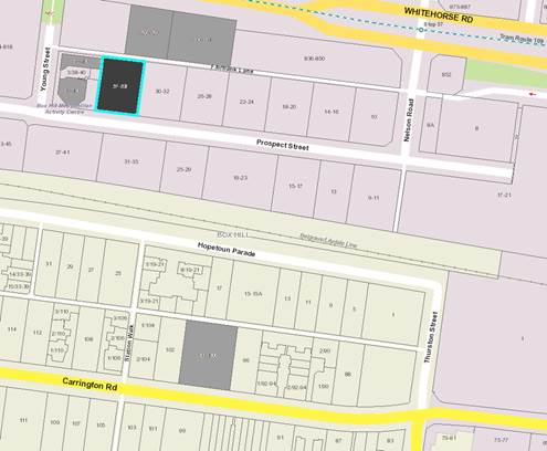
|
|
|
|
Subject site
|
|
4 Objector Properties
(0 outside of map)
|
é
North
|
BACKGROUND
The Site and Surrounds
The subject site is located
mid-block on the northern side of Prospect Street, Box Hill. It also has
frontage to Fairbank Lane to the rear (north). The site is generally
rectangular in shape, with a frontage to Prospect Street (south) of 30.48
metres, a depth of 39.62 metres, and an overall area of 1,207 square metres.
A 1.5 metre wide carriageway
easement extends along the rear (northern) boundary. The site has a fall of
approximately 4.0 metres from the south-eastern corner down to the
north-western corner.
The site is currently occupied by a
two level commercial building which is serviced by an undercroft car park,
accessible via a crossover to Fairbank Lane. The building is constructed to the
edge of the southern (front) and western (side) boundaries. It is setback more
than 4.0 metres from its eastern (side) boundary.
In terms of the immediate
interfaces:
• A
3.56m wide laneway (Fairbank Lane) extends along the northern boundary. On the
opposite side of the laneway to the north-west, at 820-824 Whitehorse Road,
Planning Permit WH/2016/68 was issued on 12 December 2016 to use the land for
accommodation, buildings and works for the construction of a 29 storey building
comprising up to 280 dwellings, with basement car parking and a reduction in
car parking requirements. This Permit was subsequently amended by VCAT Order
P273/2017, dated 7 July 2017, following an appeal against conditions. Hoarding
has been erected around the development site in preparation for construction.
On the opposite side of the laneway to the north-east, at 826-828 Whitehorse
Road, are elevated double storey office buildings. This land is the subject of
a current planning application WH/2016/1149 for Buildings and works associated
with the construction of a thirty (30) storey mixed use building, use of the
land for the purpose of accommodation where the ground floor frontage exceeds 2
metres, and reduction in the provision of car parking.
• To
the east is 30-32 Prospect Street, which is occupied by a three storey
commercial office building. This building has been constructed to the edge of
the shared boundary with the subject site, and comprises windows at each of the
three levels along this boundary.
• To
the south, the site abuts Prospect Street, which is a two-way street with
on-street parallel parking located on the northern side of the road. An
established tree canopy is planted to either side of Prospect Street. On the
opposite side of the road, at 37-41 Prospect Street, is a four storey
commercial office building. The Belgrave/ Lilydale railway line extends across
the rear of these commercial properties.
• To
the west is 38-40 Prospect Street, which is occupied by a double storey office
building. This building is constructed to the edge of the shared boundary with
the subject site and has windows for its offices in the western wall to this
abutment.
The site is a commercially zoned
area located within the Major Development Precinct designated by the Box Hill
Activity Centre Transit City Structure Plan 2007. The Box Hill Metropolitan
Activity Centre (Box Hill MAC) provides retail, education, office, civic,
medical, community facilities, entertainment, dining and recreational
opportunities for the regional population, as well as a hub for local community
activities. It is strategically located along the Melbourne to Lilydale and
Belgrave rail line, Whitehorse Road and the 109 tram route, which jointly form
the spine of an area of intensive economic activity that extends through
Melbourne’s eastern suburbs. The Box Hill Train Station and Bus
Interchange (servicing 17 bus routes) are located approximately 400 metres by
pedestrian routes to the south-east of the subject site.
Box Hill Gardens is located
approximately 400 metres to the north-east of the subject site, and Kingsley
Gardens is located approximately 300 metres to the north-west. Surrey Park,
located approximately 500 metres to the south of the site, includes both formal
and informal recreation activities.
The Box Hill MAC is experiencing
significant redevelopment, with the following sites in the vicinity of the
subject land either approved, under construction, or completed:
• 820-824
Whitehorse Road – mixed use development comprising one 29 storey tower
• 836-850
Whitehorse Road (Whitehorse Towers – “The Chen”) –
mixed use development comprising two towers of 36 storeys (114 metres) and 26
storeys (83 metres)
• 845-851
Whitehorse Road (former Spotlight) – mixed use development comprising
three towers of 17 storeys (57 metres), 30 storeys (94 metres), and 37 storeys
(117 metres)
• 913
Whitehorse Road (Australian Taxation Office) – office development of 20
storeys (81 metres)
• 545
Station Street (“Sky One”) – mixed use development of
36 storeys (123 metres)
• 12-14
Nelson Road – mixed use development of part 19 and 20 storeys (61 metres)
• 826
– 828 Whitehorse Road – 31 storey tower currently under
consideration
Planning Controls
Clause 34.01 (Commercial 1 Zone)
The site is within the Commercial 1
Zone. The purpose of the zone is to create vibrant mixed use commercial centres
for retail, office, business, entertainment and community uses, and to provide
for residential uses at densities complementary to the role and scale of the
commercial centre. Permits are required as follows:
• To
use land for the purposes of accommodation (dwellings) as the residential
component has more than 2 metres of frontage at ground level; and
• To
construct a building or construct or carry out works.
It is noted that the use of the
land for the purposes of retail, and office, do not require a permit as they
are ‘as of right’ in the Commercial 1 Zone.
Clause 45.09 (Parking Overlay)
and Clause 52.06 (Car Parking)
The site is within the Parking
Overlay. The purpose of the overlay is to facilitate an appropriate provision
of car parking spaces in an area, and to identify areas and uses where local
car parking rates apply.
The proposal generates a statutory
requirement under the Parking Overlay of 181 car parking spaces, comprising 23
spaces for the office, and 138 resident spaces and 20 visitor spaces (noting
that the use of ‘retail premises’ is not listed under the Parking
Overlay, and reference must be given to Clause 52.06 Car Parking in the
Whitehorse Planning Scheme, which has a statutory requirement of 9 car parking
spaces).
It is proposed to provide a total
of 184 car parking spaces, comprising 2 retail spaces, 23 office spaces, 138
resident spaces and 20 visitor spaces which satisfies the statutory requirement
for office spaces, resident spaces, and visitor parking spaces, but
dispensation is sought from the provision of 7 car parking spaces for the
retail premises.
This will be discussed in greater
detail later in this report.
Clause 52.07 Loading and
Unloading Facilities
Clause 52.07 (Loading and Unloading
of Vehicles) requires that no buildings or works may be constructed for the
manufacture, servicing, storage or sale of goods or materials unless space is
provided on the land for the loading and unloading of vehicles.
A permit may be granted to reduce
or waive the loading and unloading requirements.
Clause 55 (ResCode) of the
Whitehorse Planning Scheme does not apply to a development of five or more
storeys.
Clause 58 (Apartment Developments)
of the Whitehorse Planning Scheme does not apply to an application for a
planning permit lodged before the approval date of Amendment VC136 (13 April
2017).
PROPOSAL
It is proposed to construct a
mixed-use development comprising 187 apartments, commercial uses (retail and
office) within a 30 storey tower above five basement levels of car parking. The
proposed tower incorporates a podium of between approximately 19-21 metres (4
storeys). The tower form exclusively contains residential uses.
The key features of the proposal
includes:
• Two
retail premises tenancies at ground floor level. The tenancies have a combined
total leasable area of 244sqm, and direct access to the Prospect Street
frontage.
• Four
office tenancies, spread over Level 1 and 2 and located on either side of a
central lift core, with a total net floor area of 1,152sqm. A small mid-block
light court of 9m length by 2.6m width and balcony zone provide daylight to the
central area. Shared amenities including disabled facilities are provided at
each level.
• The
total commercial floor area comprises 1,396 square metres.
• A
gymnasium, swimming pool, theatre room, communal room, communal outdoor terrace
area, and change rooms are located at the southern end of Level 3. The northern
end (accessed via a swipe access security door) contains four residential
apartments each with generously scaled courtyards.
• Levels
5 to 24 adopt a common footprint. A perforated metal screen wraps around the
proposed building at its outermost edge to the south eastern corner and returns
back along the eastern frontage, resulting in a setback to the enclosed
building envelope ranging between 1.2m and 2.8m to the Prospect Street
frontage. At each level there is the provision of six two-bedroom apartments
and two one-bedroom apartments.
• An
additional outdoor communal open space terrace area is located at Level 25. At
this level, four two-bedroom apartments are proposed.
• The
apartments proposed within the development include a mix of 46 one bedroom, 138
two bedroom, and 3 three bedroom apartments, and will be located between levels
3 to 29.
• A
lobby, stairwell and two lifts provide access to all levels of the building.
• Storage
cages are provided across the basement levels, level 1 and 2.
• Each
apartment has access to a balcony, ranging in size from 8.29sqm to 68sqm.
• The
five basement car park levels contain a total of 184 car parking spaces, with
44 spaces contained within a mechanical parking system at ground floor level
which rises the equivalent of three commercial stories (extending into Levels 1
and 2). Twenty (20) visitor spaces are located in basement level 1. An
accessible car space is provided at ground level.
• The
basement will be accessed from Fairbank Lane, via two vehicle entry/ exit
points. One will provide access to the basement, and the other will provide
access to the ground floor car parking.
• Waste
management is proposed at ground floor level for both commercial and
residential areas using the same aisle for access. The application was
accompanied by a Waste Management Plan, prepared by Leigh Design and dated
November 2016, which stated that the plans indicate sufficient space for
on-site bin storage, and will comprise 12 x 1,100 litre capacity bins for
residential use (including garbage and recycling), 2 x 1,100 litre capacity
bins for commercial uses, to be collected three times per week by a private
waste contractor.
• No
loading areas are proposed.
• A
total of 64 bicycle parking spaces are provided, with eight (8) spaces provided
for the retail/ office use at ground level, and 44 spaces provided in basement
level 1. The remaining 12 spaces are located along the footpath, and will be
provided as six (6) double sided rails.
• The
design of the building incorporates a tower form, with four storey podium at
the base. The materials and colour palette includes a landscaped vertical
garden, extensive glazed elements, and feature cladding. The south elevation
and east elevations are predominantly gold coloured perforated metal screen
wraps around approximately 33% of the south elevation, returning to clad more
than 70% of the eastern elevation. The south elevation is a mixture of dark
tinted glazing and, in a stepped pattern arrangement, inclusion of what appears
to be fixed perforated screens at intervals along the façade. At podium
level, a fixed perforated screen in black metallic finish with a laser cut
arrangement indicating a landscape theme is proposed. This sits above a
relatively conventional commercial ground and first floor of concrete in situ,
described as panels. The western elevation intermixes small elements of the
perforated panels with larger expanses of a golden glass (not nominated on the
materials and finishes schedule). This lighter coloured form is framed to each
end by black composite cladding in combination with dark tinted glass.
• The
maximum overall height is approximately 94.6 metres to Fairbank Lane.
CONSULTATION
Public Notice
The application was advertised by
mail to the adjacent and nearby property owners and occupiers and by erecting
one large notice facing Prospect Street frontage. Following the advertising
period three (3) objections were received.
The issues raised in the objections
are summarised as follows:
• Overlooking
• Overshadowing
• Overdevelopment
of the site
• Increase
in local traffic congestion and pressure on existing on street car parking
spaces
• Building
to be used for the purposes of residential will undermine the precinct which is
earmarked for commercial/ office use
• Oversupply
of residential units in Box Hill
Referrals
External
VicRoads
The application was referred to Vic
Roads (under S55 of the Planning and Environment Act 1987) who advise
that they do not object to the proposal and do not require the inclusion of
conditions.
Public Transport Victoria
The application was referred to the
Director of Public Transport under S55 of the Planning and Environment Act
1987 who advise that they do not object to the proposal and do not require
the inclusion of conditions.
Internal
Engineering and Environmental
Services Department
· Transport
Engineer
The proposal was referred to
Council’s Transport Engineers who do not object subject to the inclusion
of conditions on any approval issued.
· Waste
Engineer
The proposal was referred to
Council’s Waste Services Engineers who do not object subject to the
inclusion of conditions any approval.
· Assets
Engineer
The proposal was referred to
Council’s Asset Engineers who do not object subject to the inclusion of
the conditions on any approval.
· Design
and Construction Engineer
The proposal was referred to
Council’s Design and Construction Team who do not object subject to the
inclusion of conditions on any approval issued.
ESD Advisor
The proposal was referred to
Council’s ESD Advisor who does not object subject to the inclusion of
conditions on any approval issued.
Box Hill Activity Centre Manager
The proposal was referred to the
Box Hill Activity Centre Manager. All issues raised including interface at
street level, provision of employment to the precinct, podium height along
Fairbank Lane and building entrances have been addressed by amended plans.
Urban Design Advisor
The proposal was reviewed on a
number of occasions by MGS Architects on behalf of Council with feedback
provided to both Council Officers and the Applicant’s design team. Issues
raised include setbacks of the apartment building levels 4 to 24 needing to be
increased from the north and south, inclusion of affordable and diverse housing
in the tower levels or alternatively the removal of Levels 25-29, exterior
treatments, pedestrian links at ground level, and increased diversity in the
tenure of residents within the development.
The requirement to provide a
minimum of seven (7) apartments for affordable housing will be required by way
of planning permit condition. In addition, Levels 25-29 will be retained. The
maximum overall height of the proposed building is approximately 94.6 metres to
Fairbank Lane. By way of comparison, the approved maximum overall height
of Tower 1 of the approved development at 845-851 Whitehorse Road is 117.1
metres, while the maximum height of the development at 850 Whitehorse Road is
116.75 metres to the lift over run.
Building Levels 4 to 24 are
proposed to be setback 4.5 metres from both the east and west boundaries.
Setbacks to the front (south) boundary ranges between 1.2m to 2.8 metres to
Prospect Street, increasing to 6.6m for Levels 26 to 29. Rear setbacks are more
modest, with a proposed setback to Fairbank Lane of 3.1m for its entire height,
save for the indented Level 25. The dimension of 3.1m is from the site boundary
rather than from the edge of the carriageway easement which is a further 1.5m
in width. Therefore, the proposed development will only have a 1.6m setback
from the podium level.
By way of comparison, Planning
Permit WH/2016/68 for 820-824 Whitehorse Road Box Hill which approved a thirty
storey mixed use building, is located directly opposite the site. This building
has a similar podium and tower form to that proposed on the subject site. The
podium will be four levels in height and will extend to the site boundaries.
The tower (commencing at Level 7) has setbacks of 5.0 metres from Whitehorse
Road, 8.5m from the eastern (side) boundary (except for one apartment adopting
a zero setback in the south-east corner at Level 7), and setback 4.5 metres to
the south (taken from the centre point of Fairbank Lane), which equates to
approximately 3.0 metres from the site boundary.
Property and Rates
The proposal was referred to
Council’s Property and Rates Department who do not object, and have not
sought any conditions or notes on any approval granted.
DISCUSSION
Consistency with State and Local
Planning Policies
Plan Melbourne
– The Metropolitan Planning Strategy
identifies Box Hill as a major regional centre and amongst Melbourne’s
largest centres of activity. It has a wide variety of uses and functions
including commercial, retail, housing, highly specialised medical and personal
services, education, government and tourism. State policies encourage the
intensification of Box Hill as a commercial and employment hub, supported by
one of Melbourne’s biggest transport interchanges.
Clause 16
(Housing) of the State planning policy framework also strongly advocates the
need to provide substantial new housing (in a diversity of housing types)
ensuring developments are integrated with infrastructure and services. Higher
density housing is to be located in or close to activity centres, employment
corridors and public transport. Such new development is to match changing
demand by widening housing choice, and improving affordability.
Clause 17
(Economic development) further encourages development which meets community
needs for office and other commercial services and provides net community
benefit in relation to accessibility, efficient infrastructure use and the
aggregation and sustainability of commercial facilities within existing or planned
activity centres.
Clause 18
(Transport) has objectives to encourage higher land use densities and mixed use
developments near railway stations, major bus terminals, transport interchanges
and tramways. Clause 18.02-1 promotes the use of sustainable personal
transport, including walking and cycling whilst Clause 18.02-5 requires that an
adequate supply of car parking is provided, that is appropriately designed and
located to protect amenity of residential precincts.
Clause 19.01
(Renewable energy) promotes renewable energy use in development and Clause
19-03-05 seeks to minimise waste and encourage recycling within new
development.
In terms of State
planning policy, the subject site represents a significant strategic
redevelopment opportunity to deliver higher density residential uses and
complementary commercial activity given its location within the Box Hill
Metropolitan Activity Centre. Its frontages to Prospect Street and Fairbank
Lane, and its proximity to a broad range of urban infrastructure including
public transport services, employment opportunities and commercial facilities,
further reinforce the strategic advantages of the subject site.
Local Planning
Policy Framework
Clause 21.06
(Housing), notes that the City of Whitehorse is under increased pressure to
accommodate more people who are attracted to the area due to its strategic
location, high amenity residential areas and quality services and facilities.
The Box Hill Metropolitan Activity Centre is identified to accommodate
increased housing growth while providing high levels of amenity for residents.
In this regard the proposal meets the policy objectives and will contribute to
the overall diversity of housing in the area, including a mix of one, two and
three bedroom tenures and short-term hotel accommodation. The applicant has
also agreed to include a component of ‘affordable housing’ which
will comprise seven dwellings within the residential component of the building.
This will also achieve the objective of Clause 16.01-5 (Housing affordability),
which seeks to, ‘deliver more affordable housing closer to jobs,
transport and services’.
Council’s
Housing Strategy 2014 identifies areas of substantial, natural and limited
growth. The subject site is included within a Substantial Change area which
will provide for housing growth with increased densities, in accordance with
the Box Hill Transit City Activity Centre Structure Plan 2007 (Box Hill
Structure Plan).
Clause 21.07
(Economic Development), identifies Box Hill as a Central Activities Area (CAA),
which provides significant opportunities for investment in terms of retail,
public transport, entertainment and higher density residential development.
Although the overall use of the site is largely residential, it does introduce
an office component of 1,152 square metres, in addition to retail premises at
244 square metres at ground floor level.
Clause 22.06
(Activity Centres Policy) includes objectives to ensure that new development
maintains and enhances the role of the activity centre as a community focus and
to improve the appearance and amenity of the activity centre.
Clause 22.07 (Box
Hill Central Activities Area Policy), expands upon Clause 22.06 in providing
policy direction relating to open spaces, pedestrian mobility and bicycle
spaces, road traffic management, car parking, land use mix and built form. The
policy further seeks to implement the Box Hill Structure Plan. The vision for
the Centre is that ‘Box Hill will be sustainable, safe and accessible
to all. It will be a distinctive, vibrant, diverse, inclusive, participatory,
caring and healthy community where you live, work and enjoy – day and
night’.
The structure plan
establishes precinct areas that seek to more specifically identify areas for
different forms of use and development. The subject site is located within
Activity Precinct B (Prospect Street Precinct) and Built Form Precinct F (Major
Development Precinct).
Precinct B
(Prospect Street Precinct) is identified for:
• Consolidation as the
primary office precinct in the activity centre
Precinct F
(Major Development Precinct) seeks to achieve the
following:
• Major Development Precinct:
Taller buildings permitted, enabling increased density. Heights must not cause
overshadowing of Key Open Spaces, Residential Precincts A or B or residential
areas beyond the study area. Transitional heights to be provided at edges of
the precinct to respect the scale of neighbouring precincts.
Other
Considerations
Planning Scheme
Amendment C175/ Draft Box Hill Metropolitan Activity Centre Built Form Guidelines
Amendment C175 proposes to
implement the Box Hill Metropolitan Activity Centre Built Form Guidelines
(‘the Guidelines’) into the Planning Scheme by introducing a new
schedule 6 to the Design and Development Overlay and applying it to land
identified within the Box Hill Structure Plan area. The Amendment also proposes
rezoning various sites identified within the Structure Plan and making changes
to planning policy to include the Guidelines as a reference document to the
Planning Scheme
The Amendment was
publically exhibited from 16 February 2017 to 17 March 2017. A total of 206
submissions and pro-forma responses were received. At its meeting on 15 May
2017 Council considered the submissions received and resolved to request the
Minister for Planning to appoint an Independent Panel to consider the Amendment
and submissions. An independent Planning Panel was appointed by the Minister
for Planning. The Panel Hearing was heard in July 2017, and the Panel Report
has recently been made publicly available.
The report by the
Panel highlights a number of matters for consideration by Council, and until
such time as Council has had the opportunity to thoroughly review the
recommendations made and identify its next steps, the Guidelines will continue
to give weight to the strategic guidance for built form outcomes within the Box
Hill MAC. The Amendment is considered to be a seriously entertained planning
proposal and must be given weight by decision makers until such time as Council
determines its position.
The subject site
and its immediate environs are earmarked for major development with taller
buildings and increased densities. Precinct F is the only precinct within the
structure plan where no specific preferred or maximum height limit
applies.
The Box Hill MAC
Built Form Guidelines for sites within ‘Precinct F4 –
Whitehorse Road and Prospect Street’ can be summarised as:
· 5 storey podium
· Preferred maximum building height 20 storeys
· 5m setback to all sides above podium
· 1.5m setback from laneway for vehicular access as required
· Progressive building separation:
o Up to 5 storeys – 0m
o 6 to 20 storeys – 5m
o 20 to 30 storeys – 8 metres
In terms of
compliance with current Planning Scheme Policy, the proposed development is
considered to be, in principle, appropriate for the location. The subject site
and its immediate environs are earmarked for major development with taller
buildings and increased densities. Precinct F is the only precinct within the
Box Hill MAC where no specific preferred or maximum height limit applies. This
area therefore represents a significant opportunity to deliver the proposed
mixed-use development without impacting on the amenity of any residential
neighbourhood or identified key public open space. The intensification of the
core of the Activity Centre with uses that support its strategic status and
role is supported in principle, and the proposed uses are an appropriate fit.
Design and Built Form
The applicant’s Urban Context
Report, identifies how the site acts as a ‘gateway into central Box
Hill from the west’ and is sufficiently large enough to accommodate a
mix of commercial floor space and a new residential tower. The design
sufficiently addresses each street frontage with activation including
commercial tenancies fronting Prospect Street. The height and scale of the
proposal is comparable with the recently approved development located on the
opposite side of Fairbank Lane at 820-824 Whitehorse Road with the construction
of a 30 storey mixed use building, and 826-828 Whitehorse Road where a current
planning application is contemplating a 30 storey mixed use building on the
site. These significant developments enhance the pronounced
‘gateway’ effect into the Box Hill Activity Centre.
The building form will include a
podium that extends along the Prospect Street frontage for four storeys
(varying the height between 19 and 21 metres), generally adopting a zero
setback to the streets as encouraged by the Precinct Guidelines. The ground
floor of the podium provides for commercial activities to activate the Prospect
Street frontage, with extensive use of glazed elements at the ground and first
floor level to provide for pedestrian surveillance.
The podium also has a distinctly
different architectural treatment to the tower, which serves to break up the
building bulk, provides for finer grade detailing of the streetscape, and
provides for a clear sense of address.
In terms of scale, the proposal is
considered to be consistent with the recently approved development at 820
Whitehorse Road which consists of a 30 storey tower, and the development
further east at 850 Whitehorse Road, which consists of tower of up to 36
storeys.
A 22 storey tower is found above
Level 6, with a setback of 3.0 metres from Fairbank Lane, 4.5 metres from both
the eastern and western side boundary, and 1.2 metres increasing to 2.8 metres
to the Prospect Street frontage (south). The modest setbacks to the laneway to
the north are generally not supported by Council’s Urban Design Advisor,
who views them as doing little to improve connectivity and urban quality. That
said, the proposed building has setbacks comparable to those adopted by the
adjacent development at 820-824 Whitehorse Road.
The internal amenity to be provided
to future residents is considered to be high, with the internal layout of
apartments considered to provide good daylight access. The proposal also provides
good levels of resident amenity, with facilities on Levels 3 and 25 including a
theatre, family room, gym, swimming pool, outdoor landscaping area and barbeque
facilities.
The proposed development is not
considered to have any unacceptable adverse impact on any existing significant
landmarks, views or vistas, and is therefore considered to achieve the
expectations set out in the Box Hill Structure Plan.
Services required by the proposal
are generally contained within the rear section of the podium levels within the
building and concealed from view.
The proposed plans show a variety
of construction and cladding materials. The use of composite aluminium cladding
is currently the subject of a state government taskforce due to potential high
fire risk. The use of appropriately fire rated materials will be assessed by
the Responsible Building Surveyor, it would be inappropriate for this to be
conditioned via any planning permission.
Amenity
Overlooking and access to Light
The subject site is adjoined on its
eastern and western side by an office building, and an at grade open car park
is located to the south of the site, on the opposite side of Prospect Street.
To the north-west, and located on the opposite side of Fairbank Lane, a 30
storey mixed use residential tower has been approved at 820-824 Whitehorse
Road.
In terms of equitable development,
the proposed setbacks to the tower from side and rear boundaries provide
minimum distances of 9m between the boundaries of the adjacent sites and the
edge of the balconies. This distance is acceptable and will allow for the
equitable development of this site. This will in turn avoids the need for
overlooking screening devices.
Overshadowing
The proposed building will cast
shadows across other commercial frontages. The shadow diagrams (9am to 3pm on
September 22nd) demonstrate that the shadow implications are acceptable, having
regard to the preferred built form character and streetscape vision for the
site and the surrounding area. The proposed development does not result in any
shadow being cast onto any key public open space or other spaces identified in
the Structure Plan.
The equinox shadows have a minor
impact to the established residential areas to the south, fronting Hopetoun
Parade, however this is not considered to result in any unreasonable
detrimental impact.
Wind Impact
Vipac Engineers and Scientists Ltd
have prepared a statement of wind effects for the ground level, adjacent areas,
and outdoor amenity areas of the proposed development to determine wind
conditions around the site. The results were outlined in a report dated January
2017.
Prevailing winds are noted as being
predominantly from the north, and south-west. The report finds that on the
Prospect Street frontage, the close proximity of the surrounding buildings
(currently measured as being approximately 10-20 metres in height) will shield
the proposed development from the prevailing north and south-western winds. The
setback nature of the proposed tower from the podium below also helps reduce
ground level winds, and wind conditions at footpath level will be within
walking criterion.
At Level 3, which features a Lower
Common Terrace area as well as swimming pool, is well shielded from prevailing
south-westerly winds by the location of the proposed gymnasium and the
incorporation of landscaping along the perimeter. Additionally, the featured
seating and BBQ areas are well setback from the tower above. Wind conditions
are expected to be within criterion for sitting comfort (using threshold values
for the worst annual 3-second gust velocity expected at that location in
Melbourne).
Similarly, the Common Terrace at
Level 25 is expected to be within criterion for sitting comfort due to the
shielding provided by the large canopy above, as well as landscaping along the
perimeter.
The report recommends educating
occupants about wind conditions at open terrace/ balcony areas during high-wind
events and fixing loose, lightweight furniture on the terrace.
Energy Efficiency
The orientation of the building on
the lot has maximised available solar access. The use of shared roofs, floors
and walls also promotes energy and resource efficiency.
A Sustainability
Management Plan was submitted with the application, and Council’s ESD
Officer has reviewed this. The development has been assessed as being
able to achieve an acceptable level of energy efficiency, subject to amendments
to this plan which include the provision of a Stormwater Treatment
Objective Relative Measure (STORM) Rating Report, and Built Environment
Sustainability Scorecard (BESS) report.
Internal Amenity
The development will deliver a good
level of internal amenity to future occupants of the residential apartments. At
ground floor level, separate entry to the residential building, and separate
entry to the retail and office areas are provided.
The separation achieved between the
tower and the south boundaries will provide the apartments with a satisfactory
outlook. The separation will ensure for appropriate levels of daylight and
sunlight into the apartments.
The internal layout of floors are
designed to respond to the features of the site, including the interface with
Prospect Street, and the opportunity for a northern outlook. Wherever possible,
apartments are sited with a northern, eastern or western aspect with a solely
southerly orientation limited to a small number of apartments.
Privacy between apartments, in
particular balcony locations and separation have been addressed through the
adoption of setbacks from boundaries which obviate the need to apply heavy
screening devices.
Alternate lift and stair access
linking all floor levels including the car parking is provided.
Each apartment is afforded with
generous storage areas within the secured car parking areas in the form of
cages of 6 cubic metres.
All habitable rooms have direct
access to daylight and ventilation. No habitable rooms rely on borrowed light.
The dwellings include a mix of one,
two and three bedroom dwellings. The indicative furniture layouts demonstrate
that there are a range of layout options possible for the rooms.
Each apartment is afforded an area
of private open space in the form of a balcony or terrace that all achieve an
area greater than 8 square metres in size. The areas of private open space are
further supplemented by the communal open space at Level 3, and 25. The Level 3
space contains a swimming pool and gymnasium, while Level 25 space comprises a
number of landscaped areas including seats alongside raised planter boxes and
other communal furniture.
Landscaping and Urban Art
The application includes a
landscape concept plan which shows landscaping in the form of garden areas and
within the rooftop terrace/communal open space at Level 3. It is considered
that the Level 3 podium open space requires additional infrastructure to cater
for a range of recreational purposes. The proposed development does not include
recreation space for children, and it is therefore recommended that play
equipment or playable elements such as sculpture or seating elements are
included within this open space, as listed in conditions for any approval.
is considered that in order to be
consistent with other approvals of the scale in this locality in terms of
activation of the streetscape, community benefit, and high quality built finish
outcomes, that the proposal should include an element of integrated urban art
to the ground level. As such, it is recommended that Council impose an
Integrated Art Plan by way of condition.
Uses
It is noted that the use of the
land for retail and office within the Commercial 1 Zone are as-of-right, and no
limitation is required on operating hours, although a general amenity condition
will be included on any permit issued.
Planning approval is required for
the residential uses. The provision of ground level lobby areas is acceptable,
as these provide for a sense of address and street presentation to the
residential uses.
Consistent with other recent
approvals, a condition of the permit will require the provision of seven (7)
residential apartments to be designated as ‘affordable housing
units’. This will be determined through discussions, and detailed within
conditions of any planning permit issued.
Car Parking
The site is located within the Box Hill Central Activities
Area and is therefore subject to the Box Hill Activity Centre Parking Overlay,
Clause 45.09 of the Whitehorse Planning Scheme. Accordingly, the proposal
requires the following parking provision for the proposed development:
|
Land Use
|
Number/ Area
|
Statutory Parking Rate
|
Car
Spaces Required
|
|
Dwellings:
· 1
bedroom
· 2
bedroom
· 3
bedroom
· Visitor
parking
|
|
|
|
|
46
|
0.5 spaces per dwelling
|
23
|
|
138
|
0.75 spaces per dwelling
|
103
|
|
12
|
1 space per dwelling
|
12
|
|
196
|
0.2 spaces for the first 5
dwellings plus 0.1 spaces to each subsequent dwelling
|
20
|
|
Office
|
1,152sqm
|
2 spaces per 100sqm of net floor
area
|
23
|
|
Retail*
|
244
|
No statutory parking rate provided
|
N/A
|
|
|
|
Total Parking Requirement
|
181
|
*It is noted that the proposal
includes retail floor space, for which there is no statutory rate applicable
under the planning scheme. The number of car parking spaces applied to a retail
use is to the satisfaction of the Responsible Authority.
The application proposes to include 184 parking spaces and the
allocation of the parking spaces is as follows:
|
Land
Use
|
Planning
Scheme Required Car Spaces
|
Car
Spaces Proposed
|
|
Dwellings:
· 1
bedroom
· 2
bedroom
· 3
bedroom
· Visitor
parking
|
|
|
|
23
|
23
|
|
103
|
103
|
|
12
|
12
|
|
20
|
20
|
|
Office
|
23
|
23
|
|
Retail/other
|
No statutory rate applicable
|
2 (retail) + 1 (other)
|
|
Total
|
181
|
184
|
As indicated above, the planning
scheme does not specify a parking rate for a retail use. An empirical rate has
therefore been applied to assist in the assessment of the number of car parking
spaces that may be applied as a suitable parking rate. Councils Transport
Engineers have indicated that for 244sqm of floor area, it is reasonable to
require 9 parking spaces.
That said, Council’s Traffic
Engineers have no objection to the proposed development. They note that the
proposed retail area of 244sqm is relatively small, and that the provision of
two (2) on-site staff parking spaces only is considered reasonable providing
that there is adequate parking availability in the area either on-street or
within private car parks for their customers.
The shortfall in retail customer
parking (7 car parking spaces) can be found in nearby private and public car
parking areas. The proposal also provides 1 additional space for allocation to
either residential or staff use, further reducing the parking shortfall to 6
spaces, based on the application of an empirical parking rate.
In terms of traffic generation, it
has been pointed out that a number of recent developments have either a
planning permit that involves access onto Fairbank Lane or have a planning
permit application proposing access onto Fairbank Lane. As such, a detailed
traffic impact assessment of the proposed development needs to be undertaken
which shall take into account approved developments or current development
applications that involve access onto Fairbank Lane. The report must also
detail any proposed mitigating works in the area. This will be required as a
condition on any planning permission granted.
Council’s Traffic Engineers
have recommended that, in terms of conditions to be applied to the planning permit,
similar conditions to those applied to the mixed use development at 820-824
Whitehorse Road that relate to traffic impact be placed upon this development.
These have been included in the proposed conditions on this proposal.
Bicycle Facilities
In accordance with Clause 52.34 of the Whitehorse Planning
Scheme, the number of bicycle parking spaces required is:
|
Usage
|
Number/ Area
|
Employee Rate
|
Visitor Rate
|
Required Spaces
|
|
Dwellings (4 or more storeys)
|
196 dwellings
|
1 space per 5 dwellings
|
1 space per 10 dwellings
|
58
|
|
Office >1000sqm
|
1,152sqm
|
1 space per 300sqm NFL
|
1 space per 1000sqm NFL
|
4
|
|
|
|
|
Total spaces
|
62
|
The proposal involves the provision
of 64 bicycle parking spaces which is considered satisfactory. The provision of
44 staff/ resident and 20 spaces for accessible visitor parking spaces is
considered satisfactory to meet Planning Scheme requirements.
End of trip facilities will be
provided, with a shower provided in the disabled toilet facilities on both
Level 1 and Level 2, and separate showers provided in the male and female Level
3 amenities areas. A row of lockers will be provided on Level 3, adjacent to
the amenities area.
Objectors Concerns Not
Previously Addressed
• Overdevelopment
of the site
The subject site is located within
the Box Hill Major Activity Centre, and is in a Major Development Precinct
designated by the Box Hill Activity Centre Transit City Structure Plan 2007.
The property is located close to Box Hill train station, the 109 tram route,
and Box Hill Bus Interchange (servicing 17 bus routes). In terms of planning
policy the subject site has a high degree of strategic support for an intensive,
high density development, providing retail, commercial, and residential uses.
• Increase
in local traffic congestion and pressure on existing on street car parking
spaces
The proposed development is likely
to result in an increase in local traffic. The proposal incorporates 184 car
parking spaces which will be distributed between the residential apartments,
office tenancies, and retail tenancies.
Council’s Traffic Engineers
have no objection to the proposed development.
A condition on any planning permission
issued will require a detailed traffic impact assessment of the proposed
development to be undertaken, which has regard for approved developments or
current development applications. This report is expected to detail any
proposed mitigating works in the area.
• Building
to be used for the purposes of residential will undermine the precinct which is
earmarked for commercial/ office use
The proposed development will be a
mixed use building, incorporating retail premises at ground floor, office tenancies,
and residential dwellings. It is not considered that this mixture of uses will
undermine the precinct.
The existing office building on
site provides a total area of approximately 1,200sqm of office space. The
proposal seeks to include 1,396sqm of total commercial floor area, comprising
1,152sqm of office tenancy, and 244sqm of retail tenancy.
• Oversupply
of residential units in Box Hill
The proposed development will be a
contribution to meeting Whitehorse’s future housing needs. There is
strong strategic policy support for high density housing within the Box Hill
Major Activity Centre, and the proposal is considered to be consistent with the
objectives relating to urban consolidation in the Whitehorse Planning Scheme.
CONCLUSION
The proposal for Use
of the land for accommodation (dwellings), buildings and works for the
construction of a thirty (30) storey mixed use building, comprising retail
premises, office, and dwellings, with basement car parking, and associated
reduction in the provision of car parking spaces, and waiver of loading and
unloading of vehicle requirements is an acceptable response that
satisfies the relevant provisions contained within the Whitehorse Planning
Scheme, including the State and Local Planning Policies, the Commercial 1 Zone,
and the Parking Overlay.
In addition to making a
contribution to meeting Whitehorse’s future housing needs, the proposal
provides for a mixture of uses consistent with the sites commercial zoning and
local policies applicable for the Box Hill MAC. The building has been designed
to respond to the site’s varying interfaces, to provide a high level of
amenity for future residents and to activate the street frontages. The
design of the building has been assessed by Council’s Urban Design
Consultant, and provides an appropriate built form outcome. The proposal
provides community benefits in the form of the provision of seven (7)
affordable dwellings to be given to a registered housing provider.
A total of four (4) objections were
received as a result of public notice and all of the issues raised have been
discussed as required.
It is considered that the
application should be approved.
Attachment
1 Advertised
Plans ⇨
Ordinary Council Meeting 16
October 2017
Strategic
Planning
9.1.3 Fast Track
Government Land Service - Council submission to public hearing on Box Hill
Institute sites
ATTACHMENT
SUMMARY
The Fast Track
Government Land Service is a process driven by the State Government that aims
to facilitate changes to the planning provisions for government owned sites
that have been identified as surplus to needs. This process includes public
consultation and a public hearing conducted by the Government Land Standing
Advisory Committee.
The Box Hill
Institute has determined that two sites within the Box Hill campus (eastern
part of 1000 Whitehorse Road and 16-18 Spring Street (and air rights in the
adjoining Nelson Road campus) are surplus to requirements and is using the Fast
Track process to consider amending the zoning and planning controls applying to
the sites to facilitate their disposal.
This report
outlines the Fast Track process and provides an analysis of the strategic
planning implications of rezoning the two sites. This report will form the
basis of Council’s submission to the Government Land Standing Advisory
Committee.
|
RECOMMENDATION
That Council endorse a submission to the Fast Track
Government Land Service process, including the Government Land Standing
Advisory Committee, for sites at 1000 Whitehorse Road and 16-18 Spring
Street, Box Hill that is formed on the basis of the officer assessment
contained in this report.
|
background
The Fast Track Government Land
Service (FTGLS) is a new initiative by the Victorian State Government for
surplus government owned land and aims to facilitate changes to planning
provisions or correct planning scheme anomalies for surplus government sites.
Government departments that require
planning scheme changes for their land can apply for assistance through the
FTGLS. This can include rezoning surplus government land or changes to overlay
provisions for existing sites.
The role of the FTGLS team is to facilitate
the process, provide advice to the Minister for Planning, undertake
notification to the community where necessary and prepare a planning scheme
amendment when required. The FTGLS includes preparation of standard amendment
documentation and set timeframes to complete the Fast Track process. The FTGLS
also includes public consultation and public hearings conducted by the
Government Land Standing Advisory Committee (Advisory Committee). The Advisory
Committee was established by the Minister for Planning in 2015 with the purpose
of providing independent advice on the suitability of changes to planning
provisions for land owned by the State Government.
The Box Hill Institute is seeking
to consolidate the campus footprint within the Box Hill Metropolitan Activity
Centre (MAC) to centralise their facilities and provide opportunity for the
development of future facilities. The Institute has determined that some of its
land and air rights are now surplus to requirements and seeks to use the FTGLS
to change the planning scheme provisions that apply in the Whitehorse Planning
Scheme (the Planning Scheme) to the sites to facilitate their future sale. As
part of the FTGLS, the sites will be referred to the Advisory Committee for
review.
The purpose of this report is to
provide an overview of the FTGLS process and an assessment of the implications
of rezoning the two sites. This assessment will form the basis for
Council’s submission to the Advisory Committee.
DISCUSSION
FTGLS process
The FTGLS process includes several steps which are outlined
in Table 1.
|
Step 1
|
The site
is determined to be surplus to government existing and future needs
|
Site is determined to be surplus to
requirements in accordance with the Victorian Government Landholding Policy
and Guidelines. This includes First Right of Refusal by other government
departments, agencies, Local Government and Commonwealth Government.
|
|
Step 2
|
Preliminary
assessment report is completed to recommend a Planning Stream Pathway
|
Completed by FTGLS. Consideration
of:
· Planning
controls surrounding the site
· Existing
conditions of the site and its surroundings
· Potential future
use of the site
Output: recommended Planning Stream
pathway
· any additional
reports or studies required
· indicative
timeframes and costs
|
|
Step 3
|
Implementation
of Planning Stream Pathway
|
Planning Stream A
Outcome for the site: Generally
consistent with use surrounding the site
Planning provisions: Same future
zone/planning provisions are generally the same surrounding the site
Mechanism: Planning Scheme
Amendment approved s20(4) of the Planning and Environment Act 1987
Timeframe: Considered by the
Minister for Planning 2-3 times per year
|
|
Planning Stream B
Outcome for the site: Captures a
strategic opportunity for enhanced development outcome
Planning provisions: Future
zone/planning provisions complement the surrounding area but not necessarily
the same
Mechanism: Planning Scheme
Amendment/permit considered by Advisory Committee
Timeframe: 6-8 months
|
|
Planning Stream C
Outcome for the site: All other
outcomes
Planning provisions: As
required/determined
Mechanism: Standard Planning Scheme
Amendment with either local Council or Minister for Planning as Responsible
Authority
Timeframe: 12 months
|
Table 1: Fast Track Process
Source: Fast Track Government
Land service website (www.planning.vic.gov.au/policy-and-strategy/fast-track-government-land-service/about-fast-track-government-land-service)
The FTGLS has determined that Planning Stream B is the most
appropriate planning stream pathway to implement the fast track process for the
Box Hill Institute sites.
Planning Stream B includes a consultation period (from 25
September to 3 November 2017), followed by a public hearing before the Advisory
Committee. The hearing for the Box Hill institute sites is scheduled for the 16
and 17 November 2017.
After the hearing, the Advisory Committee will deliberate on
submissions presented to them at the hearing, before submitting their
recommendation to the Minister for Planning for consideration. The Advisory
Committee timeline is outlined in Figure 1. If authorised by the Minister, a
planning scheme amendment will then be prepared to facilitate the proposed
changes to the zone and overlays affecting the sites.
Figure 1: Government Land
Standing Advisory committee timeline under
Source: Fast Track Government
Land service website (www.planning.vic.gov.au/policy-and-strategy/fast-track-government-land-service/about-fast-track-government-land-service)
Box Hill Institute sites
The following sites will be
referred to the Advisory Committee:
· Eastern
part of 1000 Whitehorse Road, Box Hill
· 16-18
Spring Street, Box Hill (including a parcel in the adjoining Nelson Road
campus)
Officers have assessed the proposed rezoning and application
of overlays, where applicable, to the two sites. An officer assessment of the
implications of the proposal is included below.
Part of 1000 Whitehorse Road, Box Hill
Subject Site
The site has frontage to Whitehorse
Road and Bank Street, Box Hill. The east part of the site is currently zoned
Public Use Zone 2 - Education (PUZ2). The site is covered by the Parking
Overlay (PO) that applies to the area covered by the Box Hill Transit City
Activity Centre Structure Plan (the Structure Plan).
The former Box Hill Girls’
Technical School is located at the front of the western part of the property
which is proposed to be retained by Box Hill Institute. This building faces
Whitehorse Road and is covered by the Heritage Overlay (HO117). A number of
multi-storey buildings are located on the remainder of the site, and along with
the former Technical School, are part of the Whitehorse campus of the Box Hill
Institute.
The site is within walking distance
to the Box Hill Transit Interchange which includes the Lilydale and Belgrave
train lines, the tram terminus on Whitehorse Road and Box Hill Gardens. The
site is also with walking distance of the core commercial and retail area of
the Box Hill MAC and is adjacent to the Box Hill Town Hall and community hub.
The eastern part of the site has
been identified as surplus to the future needs of the Box Hill Institute. The
Epworth Eastern, which is directly north of the Nelson Campus of the Box Hill
Institute, is seeking to expand its current Box Hill site. To achieve this, it
is proposed to undertake a land swap, whereby the Epworth Eastern will purchase
the site and relocate the Salvation Army’s Box Hill corps from their
existing site at 17-23 Nelson Road, Box Hill to the site at 1000 Whitehorse
Road. A concept for development of this site does not form part of the
current FTGLS process.
There is currently a plan of
subdivision lodged with Council’s Planning and Building department for
subdivision of the site and demolition of the building along the southern
boundary. The subsequent subdivision will create Lot 1 occupying an area
of 5313sqm, and Lot 2 occupying an area of 5145sqm.
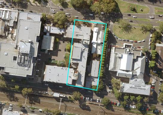
Figure 2: Box Hill Institute site at 1000 Whitehorse
Road, Box Hill
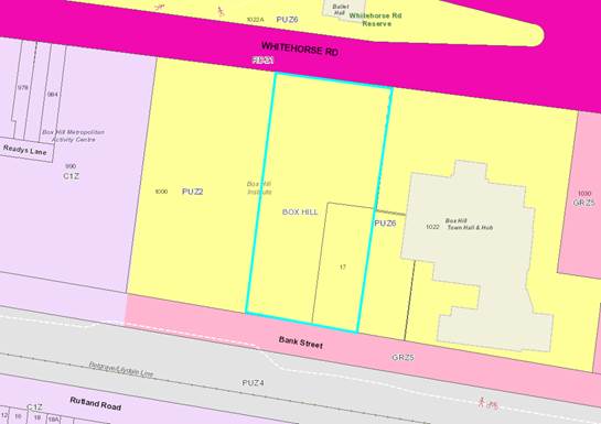
Figure 3: Current zoning of 1000 Whitehorse Road, Box Hill and surrounding
sites
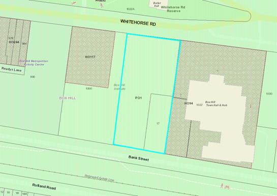
Figure 4: Current overlays on 1000 Whitehorse Road, Box
Hill and surrounding sites
Proposed changes
It is proposed that the land will
be rezoned from PUZ2 to the Commercial 1 Zone (C1Z). The purpose of the C1Z is
to:
· Create vibrant
mixed use commercial centres for retail, office, business, entertainment and
community uses.
· Provide for
residential uses at densities complementary to the role and scale of the commercial
centre.
Officer assessment
Whilst it is acknowledged that a
land swap is proposed between the Epworth Eastern, Salvation Army and Box Hill
Institute, the future use and development of this site in the longer term and
how it will relate to the surrounding area has not been identified as part of
the FTGLS process.
The C1Z zone was not envisaged for
this site by planning policy such as the Structure Plan. Whilst it is
considered logical and appropriate to rezone the site if it is no longer in
public ownership, officers have concerns with the proposed rezoning to the C1Z.
Officers are concerned that the C1Z
will allow for a greater range of as of right uses than anticipated by the
Structure Plan in this location which could undermine the intent of the precinct
and unnecessarily spread the commercial core into the civic precinct. The site
is included in Land Use Activity Precinct C in the Structure Plan, which is the
Civic and Eastern TAFE precinct and anticipates consolidation of cultural,
community and educational facilities in the precinct. These include the Box
Hill Institute, the library, the Town Hall as an arts and cultural centre and
retention of community facilities and services complementing the civic nature
of the precinct. Like other MACs in metropolitan Melbourne, such as Footscray
and Dandenong, Box Hill has a specific civic precinct which aims to support and
protect the civic function and buildings of the area.
Officers believe that an
alternative zone, such as the Mixed Use Zone (MUZ), may be a more appropriate
zone in this location. The purpose of the MUZ is
· Provide
for a range of residential, commercial, industrial and other uses which
complement the mixed-use function of the locality.
· Provide
for housing at high densities.
· Encourage
development that responds to the existing or preferred neighbourhood character
of the area.
· Facilitate
the use, development and redevelopment of land in accordance with the
objectives specified in a schedule to this zone.
While the MUZ does allow for inclusion
of objectives and clause 54 and 55 variations via the schedule, officers
believe that a Development Plan Overlay (DPO) could also be applied to the
site. This combination of controls will reinforce the objectives, intent and
expectations of the Structure Plan for this location. Planning Practice Note 23
states that a DPO is used to provide certainty about the nature of the proposed
uses and development on the site. The MUZ has also been used as a
‘transition’ from the commercial areas to the residential precincts
in the MAC.
The site is included within Built
Form Precinct E in the Structure Plan which is the Town Hall Precinct and
anticipates that civic buildings, such as the Town Hall, are given visual
emphasis and the significance of heritage buildings and related spaces are
protected. The preferred building height in the Structure Plan for this
Precinct is 4 to 6 storeys, where upper level setbacks are provided to respect
the listed heritage buildings (Box Hill Town Hall and former Technical School)
and other significant civic buildings (Box Hill Library and St Peter’s
Church). Council officers therefore have concerns with the C1Z, as this zone
does not have a mandatory height limit and any heights greater than that
included in the Structure Plan could diminish and impact on the precinct and in
particular the heritage and civic buildings and gateway to Box Hill from the
east.
Officers reiterate the application
of a DPO to this site, to provide certainty around the future use of the site.
In particular, any development on this site would need to respect the existing
heritage buildings on, and adjacent to, the site and a DPO could assist with
this and give certainty to Council and the community about how future
development would respond to these considerations.
Bank Street, directly behind the
site, is currently zoned General Residential Zone Schedule 5. Officers believe
that this should be included in the proposed rezoning to continue the zoning
along Bank Street.
Finally, officers expect that any
future development on the site respects the existing heritage buildings on, and
adjacent to, the site, such as the Box Hill Town Hall. The former school is
considered to be of outstanding historical and aesthetic significance and
demonstrates a very important phase in the history of education in Victoria.
Clause 22.01 of the Planning Scheme (Heritage Buildings and Precincts) aims
“to ensure that new land use, development, buildings and works in and
around properties subject to a Heritage Overlay is sympathetic to their
significance, character, scale, design, setbacks, form and colour
scheme”. Additionally, “the design and location of new buildings
and works should not adversely impact on the heritage value and significance of
the building(s) and/or precinct, or other features protected pursuant to the
Heritage Overlay schedule”.
16-18 Spring Street, Box Hill
(including adjacent parcel on Nelson Road campus)
Subject site
The site has frontage to Spring
Street, Box Hill. The site is approximately 2,577m2 and is currently
zoned PUZ2 and Residential Growth Zone Schedule 3 (RGZ3). The site is covered
by the PO that applies to the area covered by the Structure Plan. The site is
largely used for car parking, with trees scattered across the car park in the
southern part of the site.
The site is within walking distance
to the Box Hill Transit Interchange and the tram terminus on Whitehorse Road.
The site is also within walking distance to the Box Hill Gardens, Box Hill
Hospital, Epworth Eastern Hospital and the core commercial and retail area of
the Box Hill MAC. It is anticipated that the site will accommodate a purpose
built training facility for the Box Hill Institute to support the ongoing
training of nursing staff at the Epworth Eastern Hospital.
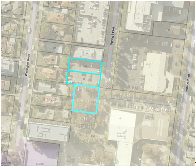
Figure 5: Box Hill Institute site at 16-18 Spring
Street, Box Hill and 853 Whitehorse Road, Box Hill

Figure 6: Current zoning of 16-18 Spring Street, Box
Hill and 853 Whitehorse Road, Box Hill

Figure 7: Current overlays on 16-18 Spring Street, Box
Hill and 853 Whitehorse Road, Box Hill
Proposed changes
It is proposed to rezone the site
from PUZ2 and RGZ3 to the MUZ and apply a new Schedule to the DPO. The purpose
of the MUZ is to:
· Provide
for a range of residential, commercial, industrial and other uses which complement
the mixed-use function of the locality.
· Provide
for housing at high densities.
· Encourage
development that responds to the existing or preferred neighbourhood character
of the area.
· Facilitate
the use, development and redevelopment of land in accordance with the
objectives specified in a schedule to this zone.
The draft Schedule to the DPO (Attachment
1) outlines the proposed requirements for the development plan and
requirements before a permit is granted. It is proposed that the development
plan must include the following requirements:
· A
site analysis that identifies existing conditions plan, showing surrounding
land uses and development, adjoining roads and pedestrian links, public
transport routes and social infrastructure.
· Concept
plans for the layout and development of the site, which show:
o The siting and
orientation of built form.
o The proposed uses of
each building.
o Three dimensional
building envelopes for new buildings, including indicative building heights,
the separation distances between buildings and the setback from street
frontages and adjoining properties.
o Shadow diagrams for the
equinox (22 September / 22 March) based on the building envelopes and
arrangements.
· Design
Guidelines for the site, which reflect the following requirements:
o The building heights
should not exceed 29 storeys in height and provide an appropriate graduation in
height.
o A mixed use podium of 4
storeys, incorporating commercial and retail uses at ground floor level and
three levels of education facilities.
o All levels above the
podium to provide for residential development.
o Car parking should be
obscured from the public realm.
o Building services,
including roof top services/elements should be screened from the public realm.
o Sustainable design
principles to address water management, solar access and energy conservation.
· An
indicative development schedule including the number, type and density of
dwellings and the floor area of any proposed non-residential uses.
· A
traffic management plan and car parking plan, which provides:
o The existing capacity of
the surrounding road network.
o An indication of roads,
pedestrian, cyclist and vehicle access locations, including parking areas both
internal and external to the site.
o An assessment of the
impact of traffic and car parking generated by the use and development upon the
surround road network.
o Car parking rates for
all uses, including visitor car parking.
o The layout of access
ways, car parking and loading areas.
o Separated areas for
pedestrian movement throughout the site and linkages to the pedestrian network.
o The provision of
convenient bicycle storage facilities.
· A
landscape concept plan for the site
The proposed development on the
site is a 29 and 24 storey building for nurse training facilities for the Box
Hill Institute in conjunction with the Epworth Eastern Hospital, and student
accommodation. It is proposed that a four storey podium will activate the
street front with retail on the ground floor and 3 levels of training
facilities above to be retained by the Box Hill Institute. The two interlocking
towers above are proposed to be set back and potentially provide for student
accommodation by developing the air rights.
Officer assessment
The MUZ was not envisaged by
planning policy such as the Structure Plan, which originally proposed that the
sites, and surrounding area, be included in the Priority Development Zone
(PDZ). The Department of Environment, Land, Water and Planning consider that
there are now more appropriate tools available within the Victoria Planning
Provisions and no longer supports the use of PDZ. Therefore the proposed zoning
to Mixed Use is consistent with the zone that is proposed to apply to the
adjacent sites to the north, east and west via Amendment C175.
Officers expect that any future
development on the site responds to the intent of the Structure Plan. The sites
are included in Land Use Activity Precinct D, which is the Hospital and Western
TAFE precinct and anticipates growth and enhancement of educational and medical
institutions and support for related businesses and services, offices, private
recreational facilities, plus high density housing (including student housing).
The proposed development responds to the intent of the Precinct D by including
training facilities for health professionals and providing student
accommodation close to the existing educational facilities. Officers are
satisfied that the proposed uses complement the land uses in the precinct.
The site is included in Built Form
Precinct F which is the Major Development Precinct and anticipates taller
buildings, enabling increased density. Heights in this precinct must not cause
overshadowing of Key Open Spaces, Residential precincts within, or beyond, the
study area. Transitional heights are to be provided at the edges of the
precinct to respect the scale of neighbouring precincts.
The proposed development has
significant building height. Recently constructed developments in the area do
not exceed 9 storeys and recently approved developments do not exceed 14
storeys. Officers are therefore concerned about the proposed heights.
The proposed development seeks a
zero/minimum setback with a hard urban edge to the ground level and podium.
Officers are therefore concerned with the proposed setbacks and site coverage
and the interface with the public realm.
Attachment 2 includes the DPO with suggested officer
revisions based on the officer assessment. Key comments regarding the DPO are
expressed below.
The proposed DPO requires that a
concept plan is prepared, showing amongst other things, shadow diagrams for the
equinox (22 September / 22 March) based on the building envelopes and
arrangements. Within Built Form Precinct F of the Structure Plan, overshadowing
of key open spaces, peripheral residential precincts or residential areas
outside the Activity Centre should be avoided between 11am-2pm on 22 June,
beyond what would result from an 11m building over the full extent of the site.
The Box Hill Gardens are identified as a key open space and are located
approximately 170m east of the site. Officers would expect any future
development to respect this open space with regards to overshadowing between
11am-2pm on 22 June.
The proposed DPO requires that
Design Guidelines are prepared for the site which reflects, amongst other
things, that all levels above the podium are to provide for residential
development. Whilst Built Form Precinct D does envisage high density
residential, the precinct also anticipates the growth and enhancement of
educational and medical institutions, related business and services, offices
and private recreational facilities. The proposed DPO should therefore reflect
this broader range of uses and remove the specific requirement for residential
development.
Council officers note that other
Schedules to the DPO in the Planning Scheme include a requirement for the
development plan to be displayed prior to approval by Council. The proposed
Schedule to the DPO does not indicate to the community what will be developed
conceptually for the site and therefore it is important to allow the community
to review the development plan, including any notice exemptions that the
Schedule allows. Officers suggest the following wording be inserted into the
proposed Schedule to the DPO:
“Before deciding whether
to approve a development plan or a substantial amendment to an approved
development plan, the responsible authority must first display the plan for
public comment for a period of at least 14 days and must consider any comments
received in response to display of the plan.
The responsible authority may
approve a minor amendment to the Development Plan without the further
requirement for a display period.”
CONSULTATION
The FTGLS and the Advisory
Committee is organising and undertaking the public consultation between Monday
25 September and Friday 3 November 2017. All inquiries during the public
consultation period are to be directed to the FTGLS.
Council has advised on the extent
of the public consultation and also provided the FTGLS with stakeholder and
interest groups that should be notified about the process. The public
consultation involves the direct notification of owners and occupiers within
the Structure Plan area and surrounding streets.
A notice about the public consultation
is scheduled to appear in the Whitehorse Leader at the commencement of the
public consultation period. A public information session is scheduled for 11
October 2017 at the Box Hill Town Hall which will be staffed by officers from
the FTGLS and the Box Hill Institute.
For the duration of the public
consultation, copies of all relevant documents will be available for viewing on
the website of the FTGLS and in hard copy at the Planning Counter at
Council’s Civic Centre in Nunawading and Council’s Box Hill
Customer Service Centre at the Box Hill Town Hall.
FINANCIAL
IMPLICATIONS
The FTGLS is covering all costs
associated with the public consultation including notification to properties,
the public notice in the Whitehorse Leader and distribution of documents.
Council will be required to pay for
all costs associated with any expert witnesses and/or representation in support
of Council at the Advisory Committee hearing. It is anticipated that Council
will call an expert witness in urban design to assist Council at the hearing
and that this expert witness can be covered by the 2017-18 budget.
POLICY IMPLICATIONS
The FTGLS supports Strategic
Direction 4 in the Council Plan (Strategic Leadership and Open and Accessible
Government).
In particular, Council is
supporting the relevant stakeholders to inform policies, projects, services and
infrastructure that deliver positive relevant outcomes for the community. The
FTGLS will deliver a transparent process that aims to facilitate the sale of
air rights at 16-18 Spring Street, Box Hill to develop new educational, health
and residential facilities for the community. Council is a party to this
process and will present at the Advisory Committee hearing.
The involvement of Council as a
party to the FTGLS process supports Strategic Direction 2 in the Council Plan
(Maintain and enhance our built environment to ensure a liveable and
sustainable city). This action is supported through Council noting its concerns
about the development proposed at 16-18 Spring Street and the proposed rezoning
of 1000 Whitehorse Road and presenting those concerns to the Advisory
Committee.
CONCLUSION
The FTGLS is an initiative by the
State Government to streamline the process of changing provisions in the
planning scheme that apply to land owned by the Government that has been
declared surplus to requirements.
The FTLGS has been utilised for two
sites within the Box Hill Institute campus footprint as they have been declared
surplus to the requirements of the Institute. Council has concerns about the
proposed changes to the planning controls for the two sites.
This report outlines implications
of the proposed changes to the two sites and recommends that this report form
the basis for Council’s submission to the FTGLS process, including the
Advisory Committee hearing.
Attachment
1 Proposed DPO
for 16-18 Spring Street, Box Hill ⇨ 
2 Revised DPO
based on officer comments for 16-18 Spring Street Box Hill ⇨ 
Ordinary Council Meeting 16
October 2017
9.2 Infrastructure
9.2.1 Tender
Evaluation Report (Contract 30001) Ballyshanassy Park Sports Fields
Reconstruction
SUMMARY
Since 2012 Council has proactively
managed the former landfill sites in the municipality with the implementation
of Landfill Management Aftercare Management Plans. To fulfil the sites
Landfill Aftercare Management Plans, and to allow Council to maintain the
sports fields to the required standards, it has been determined that the most
appropriate course of action is to reconstruct the fields. This will involve
using the latest sports field construction methods, including a substantial
drainage and irrigation system and the installation of warm season turf in line
with current Council practices. The next project is the implementation of the
Landfill Aftercare Management Plan for Ballyshanassy Park.
To consider
tenders received for Ballyshanassy Park Sports Fields Reconstruction and to
recommend the acceptance of the tender received from SJM Group Pty Ltd, trading
as SJM Turf and Civil, for the amount of $1,512,033.30, including GST and to
consider the overall project expenditure.
|
RECOMMENDATION
1. That Council accept the tender and
sign the formal contract document for Contract 30001 for the Ballyshanassy
Park Sports Fields Reconstruction received from SJM Group Pty Ltd (ABN 52 220
976 1854), of 255 Payne Rd, Beaconsfield, Victoria, 3807, trading as SJM Turf
and Civil, for the tendered amount of $1,512,033.30, including GST; as part
of the total expected project expenditure of $1,753,958.58, including GST.
2. That
Council approve the funding shortfall to be funded by the Waste Management
Reserve for the amount of $344,507, excluding GST.
|
background
Ballyshanassy Park is located on
Highbury Rd, Burwood East and is approximately 2.25 hectares in size. The
ground is predominantly used for cricket in the summer and soccer in the
winter. There is also a high amount of casual use of the park from the local
community.
The site at Ballyshanassy Park was
a former quarry from the early 1930’s to the 1960’s. Following this
the quarry was entirely filled with landfill waste, capped and converted into
soccer and cricket fields by 1972. The site has been used as sports fields
since this time and currently has no existing drainage or irrigation to allow
Council to maintain the surface to the standards required.
To fulfil the site’s Landfill
Aftercare Management Plan, and to allow Council to maintain the sports fields
to the required standards, it has been determined that the most appropriate
course of action is to reconstruct the fields. This will involve using the
latest sports field construction methods, including a substantial drainage and
irrigation system and the installation of warm season turf in line with current
Council practices. Conduits will be installed to allow for consideration of future
expanded sports field lighting at the venue.
It is proposed that the works will
start in October 2017 and be completed by end April 2018 with the ground to
remain closed to community use until 1 October 2018 to allow for full turf
establishment.
DISCUSSION
Tenders were advertised in The Age
newspaper on Saturday 12 August 2017 and were closed on Wednesday 6 September
2017. Three tenders were received.
The tenders were evaluated against
the following criteria:
a) The Tender Offer;
b) Tenderer’s knowledge and experience in
delivering similar projects on landfill sites as per set specifications within
time constraints;
c) Capacity of tenderer to undertake the works; and
d) The resources (equipment and staff) that the
contractor will be able to devote to this contract
Occupational Health & Safety
and Equal Opportunity (Pass/Fail).
SJM Turf and Civil has submitted a
tender price of $1,512,033.30 Inc GST.
From the Walker Park project
experience SJM Turf and Civil
have clearly demonstrated an excellent level of knowledge and experience in
undertaking complex sports field reconstruction projects. In addition to Walker
Park they have completed a number of turf reconstruction projects including
Gordon Barnard Reserve for Boroondara City Council, Fearon Reserve and Paisley
Oval for Hobsons Bay City Council and Flemington Reserve Oval for Melbourne
City Council. All the projects
have been undertaken to an excellent standard.
SJM Turf and Civil has demonstrated
it has the capacity and resources to perform the work within the specified
timeframes and has the
appropriate OH&S systems and EO policy in place to undertake the contract
submitted.
The submission from SJM Turf and
Civil provided a good understanding of the expected outcome including a project
plan that satisfied Council Officers that the complexities of this project are
understood. This project plan has a clear methodology and timeframes that are
realistic and achievable.
The tender received from SJM Turf
and Civil is considered to provide the best value for money for this Contract.
CONSULTATION
ParksWide Department and Parks
Planning and Recreation Unit have consulted extensively with Mitcham Baptist
Soccer Club, East Box Hill Cricket Club, Blackburn Cricket Club, Forest Hill
Cricket Club and Mitcham Cricket Club currently the tenant clubs at
Ballyshanassy Park. These clubs are fully supportive of the proposed project,
the timeframes and are looking forward to playing on a significantly improved
turf surface in the future. At the time of writing this report, it is envisaged
that all of these clubs have been able to find alternative venues for the
duration of the project.
Officers have provided an update
through a letter box drop for residents within a 400m radius of Ballyshanassy
Park.
The preferred tenderer’s
business viability has been considered.
FINANCIAL IMPLICATIONS
|
|
Budget
|
Expenditure
|
|
Capital Works Funding Account
No.(10 U424 6708)
|
$1,250,000
|
|
|
Waste
Management Reserve Account
(10
9900 9253)
|
$344,507.80
|
|
|
Total
Budget
|
$1,594,507.80
|
|
|
Preferred tenderer’s lump sum
offer (including GST)
|
|
$1,512,033.30
|
|
Less GST
|
|
-$137,457.50
|
|
Net cost to Council
|
|
$1,374,575.80
|
|
Plus Contingencies (10%)
|
|
$137,457
|
|
Plus Consultants Fees (6%)
|
|
$82,475
|
|
Total
Expenditure
|
|
$1,594,507.80
|
POLICY IMPLICATIONS
There are no Policy Implications
associated with this Report.
Ordinary Council Meeting 16
October 2017
9.2.2 Tender
Evaluation Report (Contract 30015) Koonung Creek Wetlands Boardwalk
Construction
FILE NUMBER: SF17/475
SUMMARY
Council has an ongoing program to undertake appropriate
maintenance, renewal and replacement of bridges, culverts and path structures.
Part of the program for 2017/2018 has a priority to replace the boardwalk in
the Koonung Creek Wetlands. This report is to consider tenders received for the
reconstruction of the boardwalk and to recommend the acceptance of the tender
received from Fleetwood Urban Pty Ltd, for the
amount of $470,536 including GST and to consider the overall project
expenditure.
|
RECOMMENDATION
That Council accept the
tender for the reconstruction of the boardwalk in the Koonung Creek Wetlands
received from Fleetwood Urban Pty Ltd (ABN 40 000 789 748), of 20 Sunline Drive, Truganina, VIC, 3029, for the tendered
amount of $470,536.00 including GST; as part of the total expected project
expenditure of $546,643 including GST ($513,312 excluding GST).
|
BACKGROUND
Council has an
ongoing program to undertake appropriate maintenance, renewal and replacement
of bridges, culverts and path structures. In 2013, experienced bridge
consultants undertook an inventory and structural condition assessment of all
Council road bridges, major culverts and path structures. This information was
used to develop a Council Road Bridge and Path Structure Renewal Strategy. The
Strategy is used as the basis for maintenance and renewal programs and
implementation commenced in 2015/2016.
Every two years,
experienced bridge consultants with Council officers undertake an inventory and
structural condition assessment of all Council road bridges, major culverts and
path structures. This information is used to determine priorities for the
maintenance and renewal program. The boardwalk in the Koonung Creek Wetlands
near Valda Avenue has been assessed to be in poor condition and beyond regular
maintenance and needed to be reconstructed to avoid closure due to its rapidly
deteriorating condition.
The boardwalk in
Koonung Creek Wetlands was constructed as part of the extension of the Eastern
Freeway from Doncaster Road to Springvale Road that was completed in 1997. The
Koonung Creek precinct was in recent years handed over to Council for ongoing
maintenance and renewal.
The wetlands and
the boardwalk are popular features of the Koonung Creek precinct and frequently
used by visitors to enjoy the scenery and observe local wildlife. Having a
boardwalk over a water body is a very unique feature within the municipality.
Part of the project includes an update to the current interpretive signs that
provide information on the different species of water fowl that can be found in
the wetlands.
The proposal is
to replace the old boardwalk with a new boardwalk over the wetlands and along
the same general alignment and include a ‘viewing platform’. The
new boardwalk will be approximately 2 metres wide and 112 metres long. The
design includes screw pile piles, steel structure (deck frame, stanchions and
balustrades) and Mini Mesh decking. Mini Mesh is a fibre reinforced plastic
product that has significant environmental benefits as it is durable, has good
mechanical properties and possesses high resistance to corrosion and is
relatively lightweight. The materials are more durable than the existing timber
structure and it is designed that the boardwalk will last considerably longer
and require less ongoing maintenance.
It is planned to undertake the
works during the summer months in the 2017/2018 financial year. Further notices
will be posted on site in advance of the works when the timing has been
confirmed.
DISCUSSION
Tenders were
advertised in The Age newspaper on Saturday, 26 August 2017 and were closed on
Wednesday, 20 September 2017.
A total of four
tenders were received.
The tenders were evaluated against
the following criteria:
· The
Tender Offer (price);
· Demonstrated
and relevant experience in similar work;
· Demonstrated
quality in similar work completed; and
· Availability
of the tenderer and its resources to meet required timelines.
The preferred tenderer, Fleetwood Urban Pty
Ltd, has over 45 years’ experience fabricating and installing
bridge and boardwalk works and has in-house design and manufacturing
facilities. Previous work has included the construction of pedestrian bridges
and boardwalks for estate developments in Werribee, Bendigo, Bacchus Marsh and
for Moyne Shire. This company has extensive experience and has successfully
completed a number of boardwalks in Victoria and interstate.
The tender received from Fleetwood Urban
Pty Ltd is considered to provide the best value for money for this
Contract.
CONSULTATION
The following consultation was undertaken during the design
of the boardwalk:
· The
project details were posted on social media on 2 August 2017.
· A
cover letter and the concept plan was:
o Displayed
on site on 4 August 2017
o Hand
delivered to 130 local residents on 8 August 2017
o Emailed
to Greenlink Box Hill
There were no comments received
from the cover letter and concept plan. There were 10 responses on social media
which were positive about the project.
The preferred tenderer’s
business viability has been considered.
FINANCIAL IMPLICATIONS
|
|
Budget
|
Expenditure
|
|
Capital Works Funding Account
No.U210 Footbridge and Path Structure Renewal – adopted budget
|
$ 320,000
|
|
|
Savings from other road and
footpath renewal projects
|
$ 220,000
|
|
|
Total
Budget
|
$ 540,000
|
|
|
Preferred tenderer’s lump sum
offer (including GST)
|
|
$ 470,536
|
|
Less GST
|
|
-$ 42,776
|
|
Net cost to Council
|
|
$ 427,760
|
|
Plus Contingencies
|
|
$ 42,776
|
|
Plus Project Management Fee
|
|
$ 42,776
|
|
Sub
Total Expenditure
|
|
$ 513,312
|
Ordinary Council Meeting 16
October 2017
9.3 Human
Services
9.3.1 Contract
Extension (Contract 14009) Festivals Audio Production
SUMMARY
On 12 September 2014, Council
awarded Contract 14009 for the Festivals Audio Production to Sound Solutions,
trading as Deluxe Audio following a public tender process. The original 3 year
term of the Contract will expire on 26 September 2017. The Contract allows for
a 2 year extension at Council’s discretion.
|
RECOMMENDATION
That Council extend Contract 14009 for the
Festivals Audio Production with Sound Solutions (ABN 48 258 664 107), of 9
Union Street, South Melbourne, VIC, 3205, trading as Deluxe Audio, on a
Schedule of Rates basis for a period of 2 years, commencing on 26 September
2017.
|
BACKGROUND
Each festival season, an Audio
Production Company is engaged to manage the audio production requirements of
the Festival Season and supply all audio equipment and backline. Continuity of
service is essential for the safe delivery of the festival season, and for
maintaining the high standards expected by the community. As such the provision
of this service has been tendered in order to secure a quality long term
provider. The term of the contract was three years, and the option to extend
for two years is now being sought.
DISCUSSION
On 12 September 2014, Council
awarded Contract 14009 for the Festivals Audio Production to Sound Solutions,
trading as Deluxe Audio following a public tender process. The original 3 year
term of the Contract will expire on 26 September 2017. The Contract allows for
a 2 year extension at Council’s discretion.
Deluxe Audio has delivered an
excellent standard of services over the initial term of the Contract with its
performance having been closely monitored and measured through regular
communication and meetings. The Contractor delivers Value for Money
under the Contract, and provides a high level of professionalism and service
for our festivals.
Deluxe Audio has agreed to accept
Council’s offer to extend the Contract under the current Contract terms
and conditions, subject to Council approval. The extension of this Contract
will negate the need to conduct a new tender process for these services.
CONSULTATION
Council’s Procurement
Department has been consulted with regards to the extension of this Contract.
FINANCIAL IMPLICATIONS
The contract for the provision of
Festivals Audio Production is based on an agreed Schedule of Rates. The rates
are subject to a CPI adjustment on each anniversary of the contract.
The average expenditure under this
contract over the initial contract term was $44,637, including GST per annum.
It is anticipated that the expenditure over the next 2 years will be of a
similar magnitude per annum
Ordinary Council Meeting 16
October 2017
9.3.2 Whitehorse
Health & Wellbeing Plan 2017-2021
FILE NUMBER: 17/156282
ATTACHMENT
SUMMARY
This report presents the Whitehorse Health and Wellbeing
Plan 2017-2021 (Municipal Public Health & Wellbeing Plan) for Council
adoption.
|
RECOMMENDATION
That
Council adopts the Whitehorse Health and Wellbeing Plan 2017-2021.
|
BACKGROUND
Council previously
released the draft Whitehorse Health and Wellbeing Plan 2017-2021 (the
Plan) for the purpose of undertaking further community
consultation through a public exhibition process.
DISCUSSION
The Whitehorse
Health and Wellbeing Plan 2017-2021 was developed based on three elements:
extensive community engagement, demographic information and State and Federal
policy directions.
Council has
a legislative requirement to produce the Plan and it is required to be adopted
by Council by the end October 2017. The Plan is based on a social model of
health that utilises the State Government’s Municipal Public Health
Planning Framework Environments for Health – Promoting Health and Well
Being through Built, Social, Economic and Natural Environments as the
underpinning model for the development of the Plan. It provides a
strategic planning framework, promotes partnerships and networks, highlights
local health and wellbeing issues, involves all divisions of Council, enables
the integration of wellbeing priorities and articulates links to regional,
state and national health priorities.
This iteration of the Plan has a
number of Council’s Social Plans integrated into it, providing for the
first time, a fully coordinated approach to health and wellbeing planning
across Council and the municipality, including: Diversity, Disability,
Reconciliation, Community Participation, Arts & Culture, Recreation, Early
Years, Youth and Healthy Ageing.
Comprehensive community engagement
processes informed the development of the Plan and further targeted engagement
will take place during the life of the Plan to test and confirm current
priorities and to identify new and emerging priorities. In addition, the Plan
was developed utilising an integrated planning and engagement process that also
encompassed the development of the Whitehorse Council Plan.
The following strategic directions
underpin Council’s commitment to a vibrant and prosperous community. The
goals and objectives highlighted in the Whitehorse Health and Wellbeing Plan
link to each of the Strategic Directions in the Council Plan in regard to how
Council, in partnership with the community, will respond to the
community’s priorities:
1. Support
a healthy, vibrant, inclusive and diverse community
2. Maintain and enhance our
built environments to ensure a liveable sustainable city
3. Protect and enhance our
open space and natural environments
4. Strategic leadership and
open accessible government
5. Support
a healthy local economy
A detailed analysis of the available
information/demographics, an assessment of national, state and local plans and
policies and a comprehensive engagement process, identified the following goals
for action in the Whitehorse Health and Wellbeing Plan 2017-2021:
· Connected, safe, respected and resilient
people, families and communities
· Accessible, safe and welcoming places for
all people
· A sustainable environment and shared open
spaces
· Communicating, actively engaged Council
· Economic opportunity for people
These five key thematic/priority
areas will inform and guide the development of annual action plans. The first
of these, which will be implemented throughout 2018, is attached as part of the
Whitehorse Health and Wellbeing Plan 2017-2021 (Appendix A). These yearly
Plans, developed in partnership with key partners and stakeholders, will guide
Council’s and other organisations efforts in enhancing health and
wellbeing in the municipality. Moving forward, the annual action plans under each
thematic/priority area will respond to the issues and priorities in each of the
five areas identified and respond to new and emerging priorities.
Some of the extensive breadth of
work that cross-Council departments currently carry out to respond to the needs
and priorities of the local community, will also be captured in the annual
action plans, as well as partnership work and developmental work that will
respond to new and emerging priority areas such as the prevention of violence
against women (PVAW) and so on. The Plan’s outcomes will be reported
annually to Council.
The Plan is both developed and
implemented in partnership with a diverse range of community organisations.
These partnerships include: health and wellbeing organisations, faith based organisations,
Victoria Police and many others, as well as working with other levels of
government.
As previously reported, the 2016
Census data has been gradually released during 2017 and wasn’t complete
when the Plan was presented to Council for public exhibition in August. During
the exhibition period, additional data has been received and as a result, has
now been updated in the Plan. The only demographic information that remains to
be updated is: employment, qualifications and migration. This information is
expected in November/December this year and will be subsequently reflected in
the Plan.
CONSULTATION
Whitehorse City Council recognises
and values community participation in Council’s decision-making and takes
steps to ensure that members of our community are sufficiently informed about
and are able to contribute to Council’s decision-making processes. Council’s
Community engagement in the development of the Whitehorse Health and Wellbeing
Plan ran through 2016 and 2017. Over 4,865 people from across Whitehorse
have been actively engaged and contributed to the development of the Plan,
including Councillors and Council officers.
Your Say Whitehorse
In late 2016, Whitehorse City
Council undertook an extensive community engagement process – the Your
Say Whitehorse campaign – to inform both the Whitehorse Council Plan
2017-2021 and the Whitehorse Health and Wellbeing Plan 2017-2021. Councillors and officers worked together to undertake community
workshops, pop ups, online opportunities, surveys and so forth across
the municipality, resulting in over 1,200 people participating.
A focus on health and
wellbeing
Conducted in March 2017, the Your
Say Whitehorse Health and Wellbeing survey asked the community about their main
personal health and wellbeing concerns, what helps them to feel connected to
the community, what they saw as the main health and wellbeing challenges for
people living in Whitehorse and what would have the most positive impact on
health and wellbeing. A total of 194 people participated in the survey.
Reach families and explore
specific issues
In early 2017 Council conducted
additional engagement and consultation to reach families and to explore
specific health and wellbeing issues for key groups in the community. The
findings of previous consultations and a review of the community’s health
profile informed the topics of these engagement activities.
Community Pop Ups
Community Pop Ups in high traffic
areas such as the Nunawading Library forecourt during school holidays and
Forest Hills Shopping Centre, as well as targeted focus group discussions were
held, with 349 people engaged as a result. This information has been used to
inform implementation of priority actions in the Plan that relate to people
with disabilities and their advocates, older people of culturally and
linguistically diverse backgrounds (CALD), people with mental health concerns,
people who identify as lesbian, gay, bisexual, transgender and intersex
(LGBTI), and people living in areas of socioeconomic disadvantage
Hearing from young people
In late April to early June 2017,
3,008 young people between the ages of 10 to 20 years old attending schools in
the City of Whitehorse completed a survey which measured well-being in six
empirically supported domains as important indicators of youth well-being.
Using an innovative research tool, The Well-being Profiler, Melbourne
University’s Centre for Positive Psychology conducted the study with
students from 15 different educational settings (9 primary schools and 6
secondary schools, years 5-12) across the municipality. The survey contained
additional questions about what make Whitehorse a positive place for young people,
key issues and challenges they face, local activities in which they engage and
ways in which Council could best communicate with them. Altogether, the
information from the research findings will inform planning and implementation
of a range of strategic responses to local priorities for young people, in
addition to the preliminary findings used in the development of this Plan.
Talk with stakeholders
In April 2017, a Stakeholder
Planning Workshop engaged 60 people from 40 different organisations – representing
State government, the service sector, peak bodies and local organisations and
advocates – to consider the key health and wellbeing priorities in the
City of Whitehorse and identify opportunities for collaboration and
partnerships in the implementation and evaluation of the plan. Further
discussions with partner agencies were held throughout development of the plan.
As part of the public exhibition
period, the Plan was promoted to gain further community feedback: it was
advertised in the Leader, was available at all Customer Service Centres and the
libraries, was emailed to officers to send on to their various networks and it
was also forwarded to partner agencies and the State Government. One submission
was received in response. This was from Carrington Health Services, who
specifically requested that their organisation would like to partner with
Council on initiatives relating to both social inclusion and healthy eating.
This feedback has been incorporated into the Plan. No further feedback was received.
FINANCIAL IMPLICATIONS
The financial cost to Council, in
regards to the development of the Whitehorse Health and Wellbeing Plan
2017-2021 (incorporating a number of Council’s social plans, which are
usually costed separately) is approximately $20,000.
Financial resources are also
allocated to the employment of the Health and Wellbeing Officer, whose role it
is to coordinate the development and implementation of the Plan, as well as
working on other health and wellbeing developmental initiatives.
In addition, the Community
Development Unit will:
· Explore
all external funding opportunities to progress any projects that address
priorities and issues.
· Identify priorities/issues that may fall into
the responsibility of an external service or agency
· Identify
priorities/issues that may be the current or planned responsibilities of other
Council Service Areas
POLICY IMPLICATIONS
The Whitehorse Health
and Wellbeing Plan 2017-2021 is consistent with objectives in
the Whitehorse Council Vision, the Whitehorse Council Plan and State and
Federal Government policy directions.
Attachment
1 Whitehorse
Health & Wellbeing Plan 2017-2021 ⇨
Ordinary Council Meeting 16
October 2017
9.4 Corporate
Reports
9.4.1 Annual
Report 2016-17
FILE
NUMBER:
ATTACHMENT
SUMMARY
Council’s Annual Report for the
2016-17 financial year was presented to the Minister of Local Government in
accordance with section 133 of the Local Government Act 1989 on Thursday 28
September 2017. The Annual Report 2016-17 is now presented to Council at
the Ordinary Meeting of Council on Monday 16 October 2017 in accordance with
section 134 of the Local Government Act 1989.
|
RECOMMENDATION
That Council having considered the report in
accordance with Section 134 of the Local Government Act 1989 receive and note
the Annual Report 2016-17.
|
background
Section 131 of the Local
Government Act 1989 requires Council to prepare and approve an Annual
Report containing:
a) A
report of operations of the Council;
b) An
audited performance statement;
c) Audited
financial statements;
d) A
copy of the auditor’s report on the performance statement, prepared under
section 132;
e) A
copy of the auditor’s report on the financial statements under Part 3 of
the Audit Act 1994;
f) Any
other matters required by the regulations.
Council at its meeting on Monday 21
August 2017 approved in principle the year-end financial statements and the
performance statement in advance of the Auditor-General’s consideration.
Final audit reports on the
financial statements and performance statement were received from the
Auditor-General on Tuesday 22 August 2017 and the Annual Report was submitted
to the Minister for Local Government on Thursday 28 September 2017, in
accordance with requirements of the Act.
Once submitted to the Minister of
Local Government, section 134 of the Act requires Council to consider the
Annual Report at a meeting of Council as soon as practicable. The Annual
Report will be presented to Council at the Ordinary Meeting of Council on
Monday 16 October 2017 for consideration.
Council has given public notice
that the Annual Report has been prepared and can be inspected at
Council’s customer service centres, libraries and operations centre.
DISCUSSION
In addition to fulfilling statutory
obligations, the report of Council’s performance for 2016-17 provides an
opportunity to report to the Whitehorse community about Council’s
services and initiatives during the year. The Annual Report is structured
in several sections:
- Introduction:
includes CEO’s Message, Mayor’s Message, highlights and
opportunities for 2016-17; Council’s vision, mission and values,
financial year in review and information about Council, Councillors and the
organisation.
- Our
Performance: describes Whitehorse City Council’s integrated planning and
reporting framework, and outlines the Council Plan 2013-17 strategies and
strategic indicators, Annual Plan 2016-17 major initiatives and initiatives and
Council services by the Strategic Direction as adopted in the Council Vision
2013-2023. The service performance indicators of the Local Government
Performance Reporting Framework (LGPRF) are also included in this
section.
- Governance
and Statutory Information: captures the annual statutory reporting
requirements, including reporting against various acts and regulations,
Councillor meeting attendance, documents available for inspection, audit
operations and the governance and management checklist.
- Performance
Statement: is the statement prepared under section 132 and section 133 of the
Local Government Act and reports on the Local Government Performance Reporting
Framework. The regulations require an explanation of any material variations
for all relevant indicators. Materiality thresholds have been set at +/-
10%, however commentary is given to all indicators to provide further context
to the results. The performance statement has received an unqualified
report from the Auditor-General’s office.
- Annual
Financial Report 2016-17: contains the financial statements as well as a guide
to assist readers to under their nature and content. These statements
have received an unqualified report from the Auditor-General’s office.
CONSULTATION
Under sections 131 and 134 of the Local
Government Act 1989, Council is required to advertise that the Annual
Report 2016-17 will be considered at an Ordinary Meeting of Council after the
report has been submitted to the Minister of Local Government. This was
publicised in The Age newspaper on Saturday 30 September 2017 and the
Whitehorse Leader on Monday 2 October 2017. The Annual Report 2016-17 has
also been made available at Council’s customer service centres,
libraries, operations centre and on Council’s corporate website.
FINANCIAL
IMPLICATIONS
An overview of Council’s
financial performance is presented in the Annual Report 2016-17. In the Annual
Report, there is a guide for the reader on how to understand the detailed
financial report which includes audited financial and standard
statements. The financial position of Council is strong and the audit has
been passed without qualification by the Victorian Auditor-General’s
office.
POLICY IMPLICATIONS
Publication of the Annual Report
2016-17 is a key mechanism for ensuring Council’s transparency and good
governance, and supports the achievements of objectives under strategic
direction four of the Council Vision 2013-2023 ‘Strategic leadership
and open and accessible government’.
Attachment
1 Whitehorse City
Council Annual Report 2016-17 ⇨
Ordinary Council Meeting 16
October 2017
9.4.2 2017/18
Annual Internal Audit Plan
SUMMARY
Whitehorse City Council’s 2017/18
internal audit plan has been developed by Crowe Horwath. Whitehorse City
Council’s Audit Committee charter requires approval of the annual plan by
Council.
|
RECOMMENDATION
That Council:
1. Note
the Audit Advisory Committee’s endorsement of the 2017/18 annual
internal audit plan.
2. Approve the 2017/18 annual internal audit plan.
|
background
Whitehorse City Council’s internal
audit plan is an independent, objective assurance
function designed to add value and improve Council operations. It helps Council
accomplish its objectives by bringing a systematic, disciplined approach to
evaluate and improve the effectiveness
of risk management, control, and governance processes.
Whitehorse City Council’s Audit Advisory Committee (AAC) Charter requires that an annual
internal audit plan be approved by Council each year. The role of the AAC is to
review and monitor the annual program including receiving of audit scopes and
final reports. The Chair of the AAC reports to Council on audit activities on a
six monthly basis.
DISCUSSION
The Annual Internal Audit Plan was
developed by Crowe Horwath in consultation with the Chief Executive Officer,
General Managers, selected managers and the Audit Advisory Committee.
The reviews proposed have been
nominated with consideration of the following key principles:
· To
target areas of greatest importance or concern, and/or where the potential for
improvement, or risks of failure or loss are greatest.
· To
provide a rolling program of internal audit activity that is aligned to
Council’s risk areas as noted in the risk register.
· To
take into account the nature and timing of previous internal audit activity.
· To
take into account other review activity such as VAGO’s financial and
performance audits, Independent Broad-based Anti-corruption Commission (IBAC)
reports and reports from Ombudsman Victoria relevant to Local Government.
· To
ensure an appropriate balance between compliance and process / performance
improvement focussed projects.
With these key principles in mind,
the following six areas of focus have been included in the Audit Advisory
Committee endorsed 2017/18 annual internal audit plan:
1. Procurement
2. Payroll
3. Fuel
cards
4. O
H & S
5. Former
Landfill Sites Management
6. Fraud
Management and Protection
Ordinary Council Meeting 16
October 2017
9.4.3 Domestic
Animal Management Plan
ATTACHMENT
SUMMARY
The Domestic Animals Act 1994 requires
all Victorian Councils to develop a Domestic Animal Management Plan every four
years that establishes strategies to:
· Maximise the benefits of;
· Educates the community on;
· Ensures appropriate levels of community compliance with; and
· Raise the profile of effective domestic animal management and
ownership.
This report
provides an overview of the development of the third iteration of the
Whitehorse City Council Domestic Animal Management Plan.
|
RECOMMENDATION
That Council:
1. Adopt the Domestic Animal Management Plan
2017/20 attached; and
2. Forward
a copy of the endorsed Whitehorse City Council Domestic Animal Management
Plan 2017/20 to the Secretary of Department of Economic Development, Jobs, Transport and Resources in accordance with section 68A of the Domestic Animals Act 1994.
|
background
In accordance with the section 68A
of the Domestic Animals Act 1994 (Act), Councils must now prepare and
adopt a Domestic Animal Management Plan (DAMP) every four years. The current Domestic Animal Management Plan expires in November 2017.
Whitehorse City
Council adopted its original DAMP in 2008 that had 16 key initiatives including
introducing compulsory desexing of cats and dogs, a review of dog off lead
areas, the introduction of cat curfews and the promotion of the benefits of pet
ownership.
The second DAMP endorsed in 2013, established the Domestic Animal
Management Planning Advisory Committee (DAMPAC) to consider new and emerging
issues in this area and to make recommendations to Council on domestic animal
management issues and build on the foundations established in the original plan
The Draft DAMP 2017/20 establishes
a four year Action Plan that recommends a staged approach over the life of the
Plan to review domestic animal management issues including Council’s
existing Orders made under the Act, review membership of DAMPAC and its Terms
of Reference to broaden exposure and influence and to benchmark
Whitehorse’s level of service against similar service providers to
identify opportunities
DISCUSSION
A number of key
animal management provisions established in the previous DAMPs have been in
place for up to 10 years and require review. These include:
· Off lead provisions and locations;
· The introduction of compulsory desexing of cats and dogs;
· Cat and dog prohibited areas; and
· Cat curfews
The DAMP 2017/20
will review all four Council Orders made under the Act to ensure they meet the
objectives of responsible pet ownership, meet legislative requirements and
incorporate community and stakeholder feedback
In addition, in
developing the DAMP 2017/20, consultation was conducted with stakeholders,
industry experts, the community and staff to identify key community
issues. Surveys opportunities were provided on line and promoted through
the DAMPAC network and newspaper advertising, at pop up displays in shopping
centres, parks, reserves and libraries and through one on one engagement.
The survey was a
broad based process aimed at identifying community issues to be included in the
four year DAMP Action Plan. All responses were considered and incorporated into
the process
The 96 responses
identified the following as key issues in domestic animal management:
· Enforcement of the legislation;
· Education;
· Animal registration;
· Cat curfews; and
· Off lead parks
The draft DAMP
2017/20 identifies what Council is currently doing in animal management,
recommends the retention of DAMPAC and establishes a four year action plan that
frameworks Whitehorse City Council’s activities in domestic animal
management.
Highlights of the
Action Plan include:
· A review of all Orders made under the Act relating to domestic
animal management. The process will be to carry out targeted consultation
with stakeholders, undertake a review of best practice approaches and engage
with Council departments managing open space;
· Establish a communication strategy to inform the community on key
domestic animal activities;
· Develop skills and knowledge of staff in the animal management area;
· Review DAMPAC and its Terms of Reference to ensure relevance,
stakeholder participation and its effectiveness; and
· Implement a promotion and education program to help inform our
community;
· Establish animal registration initiatives to improve reunification
levels of lost animals with their owners.
The draft DAMP 2017/20 also features Council’s
current programs and their effectiveness referencing Local Government
Victoria’s Know your Council website which demonstrates Whitehorse City
Council’s strong performance in animal management as referenced through
the Local Government Performance Reporting Framework.
Other key
statistics include:
· The high percentage of animals reunited with their owners;
· Low euthanasia rates;
· Increasing requests for services from the community;
· Nuisance management strategies;
· Our preparedness to manage animals in an emergency; and
· Responsible pet ownership incentives.
CONSULTATION
Consultation was initially carried out
through an electronic survey promoted through a series of media, holding
“pop up” displays at prominent locations including shopping
centres, Council’s Customer Service Centres, parks and libraries and
through DAMPAC membership networks.
The draft DAMP was also referred to and
considered by DAMPAC at a work shop.
FINANCIAL
IMPLICATIONS
Initiatives are expected to be
delivered through existing staff and operational budget. Annual assessment will
be made of initiatives requiring resource beyond this.
POLICY IMPLICATIONS
The DAMP 2017/20
replaces the previous 2013/16 DAMP strategy
Attachment
1 DAMP 2017-20 ⇨ 
Ordinary Council Meeting 16
October 2017
9.4.4 Supplementary
Valuation Quarterly Report - 1 July 2017 to 30 September 2017
FILE NUMBER: SF16/746#02
SUMMARY
This report
presents supplementary valuations undertaken and recommends adjustment of rate
records. The supplementary valuations have been carried out on properties in
accordance with Section 13DF of the Valuation of Land Act 1960.
|
RECOMMENDATION
That Council:
1. Note and accept the supplementary valuations
undertaken during the period commencing 1 July 2017 to 30 September 2017.
2. Authorise
the rate records being adjusted to take account of the supplementary
valuations returned.
|
background
Item 1.11 of the
Schedule of Powers contained within the Chief Executive Officer’s
Instrument of Delegation adopted by Council on 21 August 2017 states the following:
“The
delegate must not determine the issue, take the action or do the act or thing
if the issue, action, act or thing is an issue, action, act or thing which
involves:
· The return of the general valuation and any supplementary
valuations.”
This report
relates to supplementary valuations undertaken by Council in accordance with
the Valuation of Land Act 1960 for the period from 1 July 2017 to 30
September 2017.
DISCUSSION
Supplementary
valuations are conducted regularly throughout the financial year to maintain
the equity and accuracy of Council’s rating valuation base.
Supplementary
valuations are primarily due to construction, subdivision and/or planning
activities.
The supplementary
valuations undertaken are summarized in Table #1 below.
Table # 1:
Supplementary Valuations completed between: 1 July 2017and 30 September 2017
|
Supplementary Valuation Reference
|
Number of Assessments
|
SITE VALUE
|
C.I.V.
|
N.A.V.
|
|
July 2017
|
1,076
|
$401,078,000
|
$ 726,104,000
|
$36,683,400
|
|
September 2017
|
287
|
$206,811,000
|
$ 280,693,000
|
$15,764,700
|
|
Supplementary Valuations Total
|
1,363
|
$607,889,000
|
$1,006,797,000
|
$52,448,100
|
CONSULTATION
The legislative
requirement for Council to complete supplementary valuations is contained
within the Valuation of Land Act 1960. All supplementary
valuations contained in this report have been undertaken in accordance with the
2016 Valuation Best Practice Specifications Guidelines.
The supplementary
valuations in this report been certified by the Valuer- General’s office
(VGV) as being suitable for use by Council. Councils may use
supplementary valuations prior to VGV certification.
FINANCIAL IMPLICATIONS
The total change
to the Capital Improved Value (CIV) caused by the supplementary valuations
undertaken is an increase of $350,800,000.
This change in CIV
has generated an additional $588,822 of supplementary rate income.
A summary of
Council’s valuation totals for all rateable properties and non-rateable
properties are set out below in Table #2, Table #3 and Table #4.
Table #2: Valuation
totals as at 1 July 2017
|
BREAKDOWN
|
Number of Assessments
|
SITE VALUE
|
C.I.V.
|
N.A.V.
|
|
Rateable
|
71,888
|
$47,383,881,700
|
$64,528,686,500
|
$ 3,334,917,950
|
|
Non Rateable
|
1,078
|
$3,110,188,000
|
$3,519,808,500
|
$198,070,050
|
|
Municipal Total
|
72,966
|
$50,494,069,700
|
$68,048,495,000
|
$3,532,988,000
|
Table#3 Change to
valuation totals due to supplementary valuations between: 1 July 2017 to 30 September
2017
|
Supplementary Valuations
|
Assessments subject to Supplementary
Valuation
|
Change to Site Value
|
Change to CIV
|
Change to NAV
|
|
|
1,363
|
$ 7,155,500
|
$ 350,800.000
|
$19,152,800
|
Table #4: Valuation
totals as at 30 September 2017
|
NEW BREAKDOWN
|
Number of Assessments
|
SITE VALUE
|
C.I.V.
|
N.A.V.
|
|
New Rateable
|
72,484
|
$47,395,132,200
|
$64,882,466,500
|
$ 3,352,882,300
|
|
New Non Rateable
|
1,075
|
$3,106,093,000
|
$3,516,828,500
|
$199,258,500
|
|
New Municipal Total
|
73,559
|
$50,501,225,200
|
$68,399,295,000
|
$3,552,140,800
|
NB: Supplementary valuations on non-rateable properties are recorded
on Council’s rating system and their totals are included in the
supplementary valuation reports. This is because non-rateable properties
may incur a Fire Service Property Levy in accordance with the Fire Services
Property Levy Act 2012.
POLICY IMPLICATIONS
The Valuations have been undertaken
in accordance with the legislative requirements of the Valuation of Land Act
1960.
Ordinary Council Meeting 16
October 2017
9.4.5 Proposed
Sale of Strip of Council Owned Land Adjacent
55 Dorking Road, Box Hill
FILE NUMBER: SF16/746#02
SUMMARY
Section 189 the Local Government
Act 1989 restricts Council’s power to sell Council owned land.
Council at its meeting of 21 August 2017 noted that the 20m2 parcel of Council
owned land known as Lot 1 on proposed Plan of
Subdivision 812390G, being a narrow strip of land adjacent to 55
Dorking Road Box Hill was surplus to Council’s needs. Council
resolved to give public notice in accordance with Section 189 of the Local
Government Act 1989 of its intention to sell the land. Council is also
required in accordance with Section 223 of the Local Government Act 1989 to
consider any written submissions and Council is required to hear any verbal
submissions made in conjunction with any written submissions. No
submissions were received.
|
RECOMMENDATION
That Council:
1. Having
completed the public notice process in accordance with sections 189 and 223
of the Local Government Act 1989 and having received no submissions, Council
now resolves to sell the land contained within
Lot 1 on proposed Plan of Subdivision 812390G upon title release from Land
Registry by private treaty to the registered proprietors of 55 Dorking Road
Box Hill for the consideration of Sixteen Thousand Dollars ($16,000) plus GST.
2. Authorise
the Chief Executive Officer to sign all documents for the sale and transfer
of the land known as Lot 1 on proposed Plan of
Subdivision 812390G, being the land adjacent to 55 Dorking Road, Box
Hill and also authorise the affixing of the Council seal, if required, to the
documents.
|
background
At Council's
meeting of 21 August 2017 Council resolved:
That Council:
1. Note that the 25m2 of land contained
within Volume 10749 Folio 119 is surplus to Council’s requirements.
2. Acknowledge that the land contained within Volume
10749 Folio 119 has a limited market and private treaty is the preferred method
of sale.
3. Authorise
the Chief Executive Officer to commence the procedures under the Planning &
Environment Act 1987 and the Subdivision Act 1988 to subdivide the 25m2
of land contained within Volume 10749 Folio 119 into two allotments; to be
known as Lots 1 & 2 on proposed Plan of Subdivision 812390G and remove the
sewerage easement from Lot 1 on proposed Plan of Subdivision 812390G.
4. In accordance with Sections 189 and 223 of the
Local Government Act 1989, give notice of its intention to sell the 20m2
land contained within Lot 1 on proposed Plan of Subdivision 812390G upon title
release from Land Registry by private treaty to the registered proprietors of
55 Dorking Road Box Hill for the consideration of Sixteen Thousand Dollars
($16,000) plus GST.
5. Pursuant to section 223 (1) of the Local Government Act 1989
consider, and if required, hear any submissions received in regard to the
proposal to sell the land.
6. Authorise the Manager of Property & Rates to give public notice, in
accordance with Sections 189 and 223 of the Local Government Act 1989, of
Council’s intention to sell the property known as Lot 1 on proposed Plan
of Subdivision 812390G; and pursuant to Section 223 (3) of the Local Government
Act 1989, to carry out the administrative procedures to enable Council’s
Special Committee appointed to carry out its function under Section 223 of the
Local Government Act 1989 to hear and consider submissions at the meeting to be
held at Whitehorse Civic Centre Council Chamber, 379 Whitehorse Road Nunawading
on Monday 9 October 2017 at 8.00pm
7. Upon completion of the public notice process,
authorise the Manager of Property & Rates to
prepare a further Council report for Council’s consideration and
resolution.
8. Acknowledge that the 5m2 of land
contained within Lot 2 on proposed Plan of Subdivision 812390G will remain in
the name of Whitehorse City Council.
A public notice
advertising Council’s intention to sell was displayed in The Age newspaper
on Saturday 26 August 2017, in accordance with Section 189 of the Local
Government Act 1989.
The same public
notice was displayed on Council’s website for twenty-eight days in
accordance with Section 82A of the Local Government Act 1989
Council did not
receive any submissions during the submission period.
DISCUSSION
Council is the
registered proprietor of the land contained in Certificate of Title Volume
10749 Folio 119. Lot 1 on proposed Plan of
Subdivision 812390G and known as the land adjacent to
55 Dorking Road Box Hill has a narrow elongated shape and comprises 20m2 of
land.
Both the northern
and southern side boundaries of the subject land abut the property known as 55
Dorking Road, Box Hill. Potential purchasers of the land are limited to the
owner of the adjoining property at 55 Dorking Road. As
the subject land has a limited market, “private treaty” was
identified as the preferred method of sale.
The public notice
advertised by Council in The Age newspaper on Saturday 26 August 2017 stated
the proposal that Council would sell the land by “private treaty”
to the owners of the adjoining property at 55 Dorking Road, Box Hill for the
consideration of Sixteen Thousand Dollars ($16,000) plus GST,
which was established by an independent valuation dated 31 July 2017.
CONSULTATION
The formal process
regarding the selling of Council owned land is contained within Section 189 of
the Local Government Act 1989 and gives a person the right to make a
submission under Section 223 of the Local Government Act 1989.
Council is
required to give public notice that it intends to sell the subject land and
this notice gives members of the public the opportunity to make a written
submission regarding Council’s intention to sell.
In accordance with
Section 223(1) (a) a person making a written submission has the right to
request to be heard by the Committee of Council, appointed to consider and hear
submissions.
The consultation
timetable for the subject land included the following dates:
Statutory advertisements
(Public Notice): “The
Age” Saturday 26 August 2017
Closing date for
submissions: Monday 25 September 2017
Meeting to hear
submissions: Monday
9 October 2017
Public
submission/s
The closing date
for submissions was Monday 25 September 2017.
As advised no
submissions were received by the closing date.
FINANCIAL IMPLICATIONS
Gross proceeds
from the subdivision and sale of Lot 1 on proposed Plan of Subdivision
812390G will be $16,000 excluding GST.
The public notification costs and
subdivision costs are being borne by Council. After
expenses, the net proceeds to Council from the sale of Lot 1 will be
approximately $6,000 excluding GST.
Ordinary Council Meeting 16
October 2017
9.4.6 Eastern
Region Group of Councils (ERG) Future Governance Arrangements
SUMMARY
This report outlines the work undertaken
by the member Councils of the ERG in relation to:
a) Considering enhanced ERG governance
arrangements with the intention of achieving more formalised, purposeful and
impactful leverage as a distinct regional voice on matters of common
significance, importance and priority for the communities of the eastern
metropolitan region; and
b) Identifying and nominating priority actions
(strategic projects, issues and advocacy) for inclusion in the development of
an ERG 3-year strategic plan.
|
RECOMMENDATION
That Council, as a member of the eastern
regional group, endorse and approve the establishment of the Eastern Region
Group as outlined in this report including :
1. The
proposed governance arrangement as outlined in the report
2. The
proposed Council member annual financial commitment of $30,000
3. The
draft ERG Strategic Plan 2018–2020
4. The
Council’s Chief Executive Officer be authorised to oversee and approve
the ERG formal agreement
|
SUMMARY
Councils in the
eastern area of Melbourne have worked collectively over many years to advocate
on behalf of their communities. To date the Eastern Region Group (ERG) has
operated as an informal issues-based forum, managed by bi-monthly meetings of
Mayors and Chief Executive Officers (CEOs), where meeting locations and Chair
rotate between each member Council.
The eastern
councils have had a strong voice and been able to influence policy matters on a
range of issues including planning, service funding, transport, infrastructure,
affordable housing, and climate change. Examples of
this are seen in the work of the ERG as well as the Eastern Transport Coalition
(ETC), Eastern Alliance for Greenhouse Action (EAGA) and Eastern Affordable
Housing Alliance (EAHA).
In recent years
the need to respond collectively has increased in importance, particularly due
to the changing policy environment in the state and federal spheres, the
emphasis on regional planning platforms across a range of portfolio areas as
well as pressure on resources and the changing expectations of our communities.
More recent
activities including the state government review of the Local Government Act,
the MAV Act and the introduction of rate capping legislation are added
imperatives for the region to strengthen its collective effort.
This report
considers the response and deliberations of ERG Councils to the proposition
that it is timely to establish more formal arrangements that strengthen the
partnership and coordination across the eastern group of councils. It further considers the development of a 3-year strategic
plan for the region and enhanced governance arrangements to support its
implementation.
DISCUSSION
During 2014, a high-level piece of
work to review existing ERG governance arrangements was commissioned and
undertaken by Kay Rundle and Associates. This review work suggested that
increased benefits would result from a more structured approach and that a
formal governance structure would enable a co-ordinated and strategic response
across a range of regional matters.
This work further noted the extent
of other groups operating in the east, including those financially resourced by
member councils (EAHA, EAGA, ETC). It proffered that if these various groups
formed parts of one whole structure on behalf of Melbourne’s east, the
net impact would increase the profile and advocacy strength available.
Resulting from this review, in 2015
the eastern region established secretariat resources to support the ERG as an
agreed first step ahead of more structured arrangements. To this end, The
Agenda Group was contracted to supply the ERG secretariat service and assist in
the ERG’s collective work. The Agenda Group engagement as a secretariat
service to the ERG is due to conclude in December 2017.
Other changes at the regional level
include the dropping of the Regional Management Forum (RMF) model and its
replacement with a Metropolitan Partnerships arrangement introduced in June
2017. This change prompted the withdrawal of Boroondara Council from the
eastern regional group, resulting in the current ERG membership of six councils
being aligned with the Metropolitan Partnership region.
Based on the experience over the
last 2 years in having an engaged independent secretariat resource to support
co-ordination and administration of ERG work, the group has identified the
following key benefits and outcomes that can further flow from an enhanced
regional approach:
Improved visibility
Developing a
strong “regional” presence with a united view helps ensure that ERG
issues are more visible and clear to other levels of government on behalf of
our communities
Improved advocacy
Responding to
escalating pressure for councils to advocate effectively on behalf of their
communities and to achieve more meaningful influence over other levels of
government that control most of the resources which enable our communities to
function. It is vital that within a strategic and planned context that the
region agree a set of advocacy priorities.
Integrated Planning
Enhancing the
currently limited capacity to consider and pursue collaborative resource
planning across our boundaries. A more enabling environment for exploiting
integrated planning and/or service development opportunities would augment the
region’s potential to attract greater external funding and achieve better
community outcomes.
Simplified Connection to State and Federal
Government
The complexity of
demands from other levels of government can be more ably facilitated by a more
coordinated approach. A single-entry point into our region would strengthen our
capacity to respond to change at other levels of government and improve the
advocacy and planning elements.
Improved performance opportunities
The potential for councils to work
collectively at an operational level can be harnessed more readily within an
accepted regional model allowing for the assessment of economies of scale and
productivity opportunities. The current process of review of the Local
Government Act also opens opportunities which the eastern region may be able to
pursue, including establishing a more structured approach around shared
services delivery and the potential to progress entrepreneurial initiatives.
ERG Workshop of 12 July 2017
– Proposition Testing for the 2018-2020 Strategic Plan
At the request of the Mayors of the
member Councils, Councillors and Chief Executives were invited to participate
in an ERG workshop held on 12 July 2017. The core purpose of the workshop was
to test the collective appetite of ERG councils to progress more formalised,
purposeful and impactful leverage as a recognised and distinct regional voice
on matters of common significance, importance and priority for the communities
of the eastern metropolitan region.
A total of 28 workshop participants
from the six councils of the ERG, comprising 22 Councillors (including 4 Mayors
and 2 Deputy Mayors), with 5 Chief Executives and 1 Acting Chief Executive,
explored the question of whether there is a will to augment the positioning and
standing of the ERG in terms of exploiting regional leverage with the objective
of:
· Achieving
better community outcomes in a high demand environment; and
· Improving
service efficiency and effectiveness in a constrained environment.
The workshop was independently facilitated by WorkWell
Consulting. A record of the workshop proceedings was captured by
independent consultant Joe Carbone (former Chief Executive Officer of
Manningham City Council) who has been engaged to compile a Proposition Document
and the drafting of the 3 Year ERG Strategic Plan for consideration.
In summary, the Workshop process
established that there was broad willingness for the ERG to explore
collaborative approaches that augment regional leverage as a “cumulative
motive force”, whilst preserving the independence of participating
entities to use their own motive force and elect those issues on which they
believe they have substantial common interest.
The workshop proceedings reflected
a cautiously positive position on the proposition of progressing more
formalised, purposeful and impactful leverage on issues of common interest and
importance for most, if not all councils.
In reaching this position, the workshop determined some
objective guidelines around which future approaches in support of collaboration
and joint advocacy should be based. The objective guidelines and expressed
organisational tenet for the ERG going forward were collated and recorded.
This work provides a basis for
future ERG efforts, guided by a framework of desired goals, success factors
(positive conditions) and cautions (avoidance of negative conditions).
Development of Draft ERG 3 Year
Strategic Plan (2018-2020): Selection of Strategic Projects/Issues
Strategic projects and issues have
been identified and nominated for the development of the draft ERG 2018-2020
Strategic Plan.
The selected strategic projects/issues incorporated in the
draft ERG 2018-2020 Strategic Plan align with the guiding framework of desired
goals, success factors and cautions expressed in the ERG Proposition Document
as follows:
1. Contribute to the goal of creating a recognised
multi-council future vision by exploiting the opportunity to achieve greater
“net community benefit” across the region from improved returns on
capital and/or service effectiveness, including enhanced likelihood of attracting
greater external funding;
2. Support the goal of whole region integrated planning
which facilitates opportunities to:
a) Pursue advantageous planning across municipal
boundaries covering the dimensions of social and/or infrastructure planning on
a regional level;
b) Exploit possible advantages of:
i. Pooled resourcing (specialist staff)
ii. Information sharing and common systems
development
iii. Joint research effort
iv. Developing common operational tools and standards
v. Aligning work with existing plans and groups that
are already making progress across municipal boundaries
3. Strengthen external advocacy and promotion of an ERG
single identified voice for the region;
4. Achieve positive outcomes for the benefit of the
region and its communities that can be quantified and evaluated; and
5. Avoid negative conditions such as duplication,
“relevance deprivation” and competing interests between councils.
Draft ERG 2018–2020 Strategic Plan
The framework of the developed draft ERG Strategic Plan is
built around 3 core elements as set out in the table below:
Whilst the above strategic plan model represents the
structured approach for the next recommended iteration of the ERG, it is also
pertinent for the ERG to be continually and actively responsive to emerging
sector issues of significance as they arise as has been past practice.
Collaborative monitoring and assessment of political, service
and financial impacts of proposed public policy changes driven by State and/or
Federal government as affects Local Government, particularly as may
specifically impact the eastern region Councils, should continue to be under
ongoing watch by the ERG. It is proffered that this needs to be a continuing
core component of the ERG role and more particularly in the current environment
where potential changes to MAV are yet to play out.
This report recommends that the
draft ERG Strategic Plan 2018–2020 be adopted by Council as a member of
the ERG. The ERG is to further refine the draft Strategic Plan in terms of
assessing and agreeing the achievable work schedule for the three years.
ERG relationship with existing regional groups functioning
in the eastern metropolitan region
The significant work of the
following 3 key regional issues based groups is recognised:
· Eastern
Transport Coalition (ETC);
· Eastern
Affordable Housing Alliance (EAHA); and
· Eastern
Alliance for Greenhouse Action (EAGA)
These groups have been effective in
their areas of focus but to date there has been no clear alignment between
their operation and the ERG. The Report of May 2014 recommended the linking of
these groups with the eastern metropolitan Mayors and CEOs forum similar to the
way in which some other established regions work with subject matter sub-groups
through formal structures e.g. G21, IMAP, NorthLink and LeadWest.
As an initial step towards testing
and pursuing a clearer and more meaningful connection between the above groups
and the ERG, a reporting relationship development approach is suggested which
facilitates shared reporting as well as strategic alignment on agreed/common
priorities. In so pursuing such a development path, there would be the
opportunity to enhance and better co-ordinate the advocacy effort of the
region.
The ERG councils currently commit
funding and resources to the ETC, EAHA and EAGA as follows:
· ETC
- $8,000 annual fee plus $14,000 for a 3-year advocacy campaign per member
council. Current membership comprises all ERG councils plus Greater Dandenong
· EAHA
- $7,000 p.a. per member council for a 0.4 EFT administrative resource. Current
membership comprises all ERG councils.
· EAGA
- $20,000 p.a. per member council. Current membership comprises all ERG
councils except Manningham, plus Boroondara, Stonnington and Glen Eira.
The financial commitment by
member councils to the ERG currently is a total of $30,000 p.a. This funding is
largely allocated to the contracted secretariat support service. The current
secretariat service is provided by The Agenda Group, whose service contract
expires in December 2017. For the last 3 years, ERG funding included the
contribution of Boroondara Council which is now no longer part of the ERG.
Given the significant cumulative
investment of eastern region councils in support of regional advocacy and
political lobbying activity, it is imperative for the region to optimise such
resources and energy through the opportunity of improved collaboration and
integration of effort. The development path suggested in this report commences
with the establishment of agreed reporting relationships between the key
regional groups and the ERG. It is recommended that this development approach
form part of the year 1 agenda of the ERG in collaboration with the ETC, EAGA
and EAHA.
ERG Governance
The formal governance model
proposed for the ERG is in the form of an Eastern Regional Group of Councils
Agreement made pursuant to s. 193 of the Local Government Act 1989.
In future, changes to the Local
Government Act may provide some opportunities or alternate legal options that
can be explored such as the Incorporated Associations Act and/or extended
entrepreneurial provisions. The Local Government Act review may indeed
reinforce the need for stronger regional partnerships of Councils.
Membership of the ERG is open to the
six councils of the eastern metropolitan region of Melbourne comprising Knox,
Manningham, Maroondah, Monash, Whitehorse and Yarra Ranges.
Each participating council would be
an entity member of the ERG and would contribute financially towards the
secretariat and administrative function of the ERG in overseeing the
implementation of the adopted regional strategic plan.
Included in the role and function
of the ERG is the development of appropriate reporting and working relationship
links with existing regional groups i.e. ETC, EAGA and EAHA to ensure their
alignment with the work and supported priorities of the region and their
ongoing momentum in their focus areas.
The Mayor from each member council
forms the overarching eastern region entity which is to be supported by
secretariat support resources as well a range of collaborative sub-committees
established based on strategic need as determined in the adopted strategic
regional plan.
The Mayors group would elect a
chair who would preside over the ERG for that full year commencing in December
of each year.
In addition to the membership of
the Mayors, the ERG would also include membership of a further nominated
Councillor from each member council. Council Chief Executives and the
secretariat representative are ex-officio attending members of the ERG, thereby
voting rights are held by Councillor members only.
It is envisaged that the ERG would
meet bi-monthly to oversee the implementation of the adopted strategic plan.
Chief Executive Officers would continue to ensure that key emerging issues
affecting the local government sector are raised and addressed by the ERG.
In view of the current review of
the Municipal Association of Victoria (MAV) Act, and in association with
providing input to the further review processes underway by the MAV, the ERG
will need to raise the question of MAV regional boundaries and their
non-alignment with any existing state or federal boundaries.
Corporate service operational
support provided to the ERG by any member council in terms of human resource
management, financial operations, IT and/or office accommodation services is to
be reimbursed at cost.
It is anticipated that Mayors and
CEOs of the ERG would provide quarterly feedback to their respective councils
on the progress of the ERG and status of strategic plan implementation.
The financial commitment of member
councils is proposed to be maintained at the current level of $30,000 per
council per annum. The level of annual contribution per council would be
subject to annual review and approval.
CONSULTATION
As outlined in this report, there
has been a high level of engagement across the region over a period of years,
including the most recent July workshop where all councillors from the eastern
region were invited to participate. The current Eastern Region Mayors and
CEO’s group have also played a leadership role in guiding the work
leading to this proposal during the past year.
FINANCIAL IMPLICATIONS
The primary direct resource to
support the operation of the ERG is a secretariat that provides an executive
officer function for meetings, communications and co-ordination of follow up
ERG business.
As part of the implementation
process of the ERG Strategic Plan 2018-2020, councils will deploy existing
resources that are already committed to regionally based collaborative projects
and activities. Opportunities will also emerge to consider the potential
pooling of specialist resources across the region as well as joint resourcing
of research efforts for greater mutual benefit to all member councils.
CONCLUSION
This report reflects a considered
motivation on the part of the member councils of the ERG to augment its
standing and positioning as a stronger, more identifiable and influential voice
in the face of greater emphasis on regional planning platforms by state and
federal government in a changing policy environment across a range of portfolio
areas.
Essential to progressing the ERG
from its current standing as an informal collegiate based issues forum, to a
more formalised, purposeful and united representative body for the eastern
metropolitan region of Melbourne, is the development and adoption of a
formative 3-year strategic plan for the regional group.
In addition to recommending to
Council that it approve and adopt the draft ERG 2018-2020 Strategic Plan
developed in line with guidelines proposed from workshop consultation involving
member councils, the report further recommends the approval of proposed formal
ERG governance arrangements and Council financial commitment.
Ordinary Council Meeting 16
October 2017
9.4.7 Meeting
Cycle January to December 2018
SUMMARY
This report is to set the meeting dates
for the period January to December 2018. It is recommended that Council
continue with the current meeting cycle which provides for meetings to take
place on Monday nights as follows:
Week 1 – Strategic Planning
Session
Week 2 – Councillor Briefing and
Special Committee Meeting.
Week 3 – Council Meeting
|
RECOMMENDATION
That:
1. The report be received and noted and the
Meeting Cycle for the period January to December 2018 as detailed in Appendix
A to this report be adopted.
2. Meetings of the Council and Special Committee
of Council be held in the Council Chamber, 379 Whitehorse Road, Nunawading,
with the exception of the first Ordinary Council Meeting of the year Monday
29 January 2018 which will be held in the Council Chamber Box Hill Town Hall.
3. Public
notice of Council’s meeting schedule be given as required by Section 89
(4) of the Local Government Act 1989.
|
background
The Council Meeting Cycle is currently as follows:
|
Week 1
|
Week 2
|
Week 3
|
|
6.30pm
Strategic Planning Session
(not a formal or public meeting)
|
6.30 - 8.00pm
Councillor Briefing
Information gathering for briefing on agenda for Council
Meeting on Week 3
(not a formal or public meeting)
8.00pm
Special Committee of Council Meeting
|
7.00pm
Council Meeting
|
This report is to set meeting dates for the period January
to December 2018 as listed in Appendix A to this report.
It is recommended that Council continue with the current
meeting cycle which provides for meetings to take place on Monday nights as
follows:
Week 1 – Strategic Planning Session
Week 2 – Councillor Briefing and Special Committee
Meeting
Week 3 – Council Meeting
· Meetings
will take place on Monday nights in a four weekly cycle, with Week 4 (and Week
5 in those months with a fifth Monday) being a meeting free night, to schedule
other matters for consideration as necessary. Where Monday is a public
holiday the meeting will take place on the Tuesday night immediately following.
· During
January the Councillor Briefing will be held on Monday 22 January and the first
Ordinary Council Meeting for 2018 will be held Week 4 of January (nb the
Ordinary Council meeting Monday 29 January 2018 will be held at the Box Hill
Town Hall)
· The
meeting cycle has been adjusted in June due to the Australian Local Governance
Association National General Assembly being scheduled for June 2018.
· Strategic
Planning Sessions will be held from February to October 2018 inclusive.
· Special
Committee of Council meetings will be held from February to December 2018
inclusive.
· All
meetings will be conducted in accordance with the Charters and Council’s
Meeting Procedure and Common Seal Local Law 2013.
CONSULTATION
Councillors are familiar with the meeting cycle, structure
and Council meeting processes.
FINANCIAL IMPLICATIONS
There are no financial implications associated with this
report.
POLICY IMPLICATIONS
There are no policy implications associated with this
report.
MEETING
CYCLE 2018 – Public
|
January
|
|
Ordinary Council Meeting
|
29
|
|
February
|
|
Special Committee
Ordinary Council Meeting
|
12
19
|
|
March
|
|
Special Committee
|
13 (Tues)
|
|
Ordinary Council Meeting
|
19
|
|
April
|
|
Special Committee
|
16
|
|
Ordinary Council Meeting
|
23
|
|
May
|
|
Special Committee
|
14
|
|
Ordinary Council Meeting
|
21
|
|
June
|
|
Special Committee
|
12 (Tues)
|
|
Ordinary Council Meeting1
|
25 1
|
|
July
|
|
|
Special Committee
|
9
|
|
Ordinary Council Meeting
|
16
|
|
August
|
|
|
Special Committee
|
13
|
|
Ordinary Council Meeting
|
20
|
|
September
|
|
|
Special Committee
|
10
|
|
Ordinary Council Meeting
|
17
|
|
October
|
|
|
Special Committee
|
8
|
|
Ordinary Council Meeting
|
15
|
|
Special (Statutory) Council Meeting –Election
of the Mayor
|
29
|
|
November
|
|
|
Special Committee
|
12
|
|
Ordinary Council Meeting
|
19
|
|
December
|
|
|
Special Committee
|
3
|
|
Ordinary Council Meeting
|
10
|
· Additional meetings may be called as required and will
be advertised in local newspapers when possible and/or by notice on the public
noticeboards at Civic Offices.
· All meetings to be held in the Council Chamber,
Whitehorse Civic Centre, 379 Whitehorse Rd, Nunawading, with the exception of
the meeting scheduled for *Monday 29 January 2018, which will be held in the
Council Chamber, Box Hill Town Hall*
· Council Meetings commence at 7.00pm unless otherwise
advised. Special Committee of Council Meetings commence at 8.00pm unless
otherwise advised. All meetings open to the public, unless Council
resolves to close the meeting to the public to consider an item ‘in
camera’.
· Meetings subject to change as necessary, changes to the
meeting cycle will be advised by public notice as appropriate.
1 Meeting
schedule adjusted due to ALGA National Conference scheduled 17-20 June 2018
Ordinary Council Meeting 16
October 2017
9.4.8 Adoption
of Instrument of Appointment and Authorisation under the Planning and
Environment Act 1987
SUMMARY
The purpose of this report is to
recommend approval of Instrument of Appointment and Authorisation under the
Planning and Environment Act 1987, from the Council to positions in the
organisation.
|
RECOMMENDATION
That Council approve the proposed appointment of
authorised officers pursuant to the Planning and Environment Act 1987 as
attached to this report.
|
background
The proposed Instrument of
Appointment and Authorisation (pursuant to the Planning and Environment Act
1987) has been prepared following advice received from Council’s
solicitors Maddocks and is similar to that used by many Victorian
municipalities.
The Instrument of Appointment and
Authorisation allows Council officers to conduct their normal business in
relation to enforcement of the Planning and Environment Act 1987 and to
act and commence proceedings in Council’s name.
These appointments
must be made by resolution of the Council; section 3(6) of the Local Government
Act 1989 defines ‘resolution of the council’ as including a
power exercised under delegation (ie: by the Chief Executive Officer), however
section 188 (2) (c) of the Planning and Environment Act 1987 prohibits
authorisations being made under delegation.
The Instruments of Appointment and
Authorisation would come into force once the common seal is affixed to the
Instrument.
CONSULTATION
Relevant staff including General
Manager City Development and Manager Planning and Building were consulted
during the preparation of the proposed Instrument of Appointment and
Authorisation.
FINANCIAL
IMPLICATIONS
There are no financial
implications.
POLICY IMPLICATIONS
There are no policy implications.
Whitehorse
City Council
Instrument
of Appointment and Authorisation
under
the Planning and Environment Act 1987
|
STAFF
|
|
Surname
|
Given
name
|
|
KILLIN
|
Emily
|
|
WELLS
|
Natalie
|
|
SINNATT
|
Sue
|
Instrument of Appointment and Authorisation
(Planning and Environment Act 1987)
In this
instrument "officer" means:
a) Emily Killin;
b) Natalie Wells;
c) Sue Sinnatt.
By this
instrument of appointment and authorisation Whitehorse City Council:
a) Under section 147(4) of the Planning
and Environment Act 1987 - appoints the officer(s) to be an
authorised officer(s) for the purposes of the Planning and Environment Act
1987 and the regulations made under that Act; and
b) Under section 232 of the Local
Government Act 1989 authorises the officer(s) generally to institute
proceedings for offences against the Acts and regulations described in this
instrument.
It is declared that
this instrument -
a) Comes into force immediately upon its
execution; and
b) Remains
in force until varied or revoked.
This
instrument is authorised by a resolution of the Whitehorse City Council on
17 October 2017
|
THE
COMMON SEAL OF THE WHITEHORSE CITY COUNCIL was hereunto affixed this
day
of October 2017 in the presence of:
______________________
Councillor
______________________
Chief
Executive Officer
|
)
)
)
)
)
)
)
)
)
)
)
)
)
|
Ordinary Council Meeting 16
October 2017
9.4.9 Delegated
Decisions August 2017
SUMMARY
The following activity was undertaken by officers under
delegated authority during August 2017.
|
RECOMMENDATION
That the report of decisions made by officers under
Instruments of Delegation for the month of August 2017 be noted.
|
|
DELEGATION
|
FUNCTION
|
Number for August 2016
|
Number for August 2017
|
|
Planning and Environment Act
1987
|
Delegated Decisions
|
190
|
133
|
|
Strategic Planning Decisions
|
Nil
|
Nil
|
|
Telecommunications Act 1997
|
|
Nil
|
Nil
|
|
Subdivision Act 1988
|
|
30
|
34
|
|
Gaming Control Act 1991
|
|
Nil
|
Nil
|
|
Building Act 1993
|
Dispensations & Applications to
Building Control Commission
|
92
|
94
|
|
Liquor Control Reform Act 1998
|
Objections and Prosecutions
|
Nil
|
Nil
|
|
Food Act 1984
|
Food Act Orders
|
6
|
7
|
|
Public Health & Wellbeing Act
2008
|
Improvement /
Prohibition Notices
|
1
|
3
|
|
Local Government Act 1989
|
Temporary Road Closures
|
17
|
4
|
|
Other Delegations
|
CEO Signed Contracts between $150,000 -
$500,000
|
1
|
1
|
|
Property Sales and Leases
|
15
|
7
|
|
Documents to which Council seal affixed
|
1
|
5
|
|
Vendor Payments
|
940
|
1114
|
|
Parking Amendments
|
8
|
7
|
|
Parking Infringements written off (not
able to be collected)
|
550
|
290
|
DELEGATED DECISIONS MADE ON PLANNING APPLICATIONS AUGUST
2017
All
decisions are the subject of conditions which may in some circumstances alter
the use of development approved, or specific grounds of refusal is an
application is not supported.
|
Appl
No.
|
Dec. Date
|
Decision
|
Street Address
|
Ward
|
Proposed Use or Development
|
Application
Type
|
|
WH/2017/221
|
31-08-17
|
Application Lapsed
|
7 James Avenue MITCHAM VIC 3132
|
Springfield
|
Construction of Secondary (double storey)
dwelling
|
Multiple Dwellings
|
|
WH/2017/358
|
24-08-17
|
Application Lapsed
|
78 Middleborough Road BURWOOD EAST VIC 3151
|
Riversdale
|
Display of major promotion signage
|
Advertising Sign
|
|
WH/2017/417
|
08-08-17
|
Application Lapsed
|
9 Boongarry Avenue BLACKBURN
VIC 3130
|
Central
|
Construction of buildings and works
(verandah) in Significant Landscape Overlay (SLO1)
|
Special Landscape Area
|
|
WH/2017/426
|
24-08-17
|
Application Lapsed
|
5 Crest Grove NUNAWADING VIC 3131
|
Springfield
|
Construction of four double storey
dwellings
|
Multiple Dwellings
|
|
WH/2014/1243/A
|
09-08-17
|
Delegate Approval - S72 Amendment
|
16 La Frank Street BURWOOD VIC 3125
|
Riversdale
|
Construction of one double storey
dwelling to the rear of the existing dwelling
|
Permit Amendment
|
|
WH/2014/271/A
|
22-08-17
|
Delegate Approval - S72 Amendment
|
5 Belmont Street SURREY HILLS VIC 3127
|
Riversdale
|
Construction of three double storey
dwellings
|
Permit Amendment
|
|
WH/2014/528/A
|
30-08-17
|
Delegate Approval - S72 Amendment
|
38 Killara Street BOX HILL NORTH VIC 3129
|
Elgar
|
The development of the land for two
dwellings comprising one double storey dwelling to the rear of the existing
single storey dwelling
|
Permit Amendment
|
|
WH/2015/1030/A
|
30-08-17
|
Delegate Approval - S72 Amendment
|
23 Clifton Street BOX HILL SOUTH VIC 3128
|
Riversdale
|
Amendment to Planning Permit WH/2015/1030
(Construction of two (2) double storey dwellings) to amend plans and
condition 1.a) to allow direct access to dwelling entrances off Clifton
Street and the relocation of garages further forward to Clifton Street
|
Permit Amendment
|
|
WH/2015/1084/B
|
22-08-17
|
Delegate Approval - S72 Amendment
|
3-5 Springfield Road BLACKBURN NORTH VIC 3130
|
Central
|
Amendment to Planning Permit WH/2015/1084
issued for Buildings and works associated with an existing place of worship
and use of the land for a car park
|
Permit Amendment
|
|
WH/2015/341/A
|
18-08-17
|
Delegate Approval - S72 Amendment
|
11 Newbigin Street BURWOOD VIC 3125
|
Riversdale
|
Construction of three double storey
dwellings
|
Permit Amendment
|
|
WH/2015/530/B
|
01-08-17
|
Delegate Approval - S72 Amendment
|
19 Premier Avenue MITCHAM VIC 3132
|
Springfield
|
Amendment To Planning Permit Wh/2015/530
(Issued On 12 January 2016 For The Construction Of Two Double Storey
Dwellings) To Extend Bedrooms 3 And 4 Of Unit 2 One Metre North-East
|
Permit Amendment
|
|
WH/2015/715/B
|
10-08-17
|
Delegate Approval - S72 Amendment
|
12-14 Nelson Road BOX HILL VIC 3128
|
Elgar
|
Construction of a Part 19, Part 20 storey
building, comprising dwellings, retail space and offices, with basement car
park, use of the building for accommodation (dwellings), and reduction of the
parking requirements of Clause 52.06 of the Whitehorse Planning Scheme to
alter configuration of apartments and parking layout.
|
Permit Amendment
|
|
WH/2015/860/A
|
30-08-17
|
Delegate Approval - S72 Amendment
|
7 Unley Court VERMONT VIC 3133
|
Morack
|
Construction of one (1) double storey
dwelling to the rear of an existing dwelling
|
Permit Amendment
|
|
WH/2016/562/A
|
18-08-17
|
Delegate Approval - S72 Amendment
|
11 Peacock Street BURWOOD VIC 3125
|
Riversdale
|
Construction of three (3) double storey
dwellings
|
Permit Amendment
|
WH/2016/996/A
|
17-08-17
|
Delegate Approval - S72 Amendment
|
613 Whitehorse Road MITCHAM VIC 3132
|
Springfield
|
Change of use to a minor sports and
recreation facility (badminton courts) and associated display of a floodlit
business identification sign and a waiver of bicycle facilities requirements
|
Permit Amendment
|
|
WH/2016/1024
|
31-08-17
|
Delegate NOD Issued
|
425 Mitcham Road MITCHAM VIC 3132
|
Springfield
|
The construction of three (3) double
storey dwellings, alterations of access to a road in a Road Zone Category 1
|
Multiple Dwellings
|
|
WH/2016/1161
|
25-08-17
|
Delegate NOD Issued
|
127 Springfield Road BLACKBURN NORTH VIC
3130
|
Central
|
Construction of three (3) double storey
dwellings
|
Multiple Dwellings
|
|
WH/2016/1200
|
22-08-17
|
Delegate NOD Issued
|
81 Broughton Road SURREY HILLS VIC 3127
|
Riversdale
|
To construct two double storey dwellings
and to subdivide the land into two lots
|
Multiple Dwellings
|
|
WH/2016/1205
|
28-08-17
|
Delegate NOD Issued
|
33 Lasiandra Avenue FOREST HILL VIC 3131
|
Springfield
|
Construction of two dwellings comprising
one double storey dwelling and one single storey dwelling to the rear
|
Multiple Dwellings
|
|
WH/2016/138
|
04-08-17
|
Delegate NOD Issued
|
13 Hopetoun Parade BOX HILL VIC 3128
|
Elgar
|
Construction of a 5 storey residential
development plus basement
|
Multiple Dwellings
|
|
WH/2016/644
|
07-08-17
|
Delegate NOD Issued
|
2 Shaun Avenue BLACKBURN SOUTH VIC 3130
|
Riversdale
|
The construction of two (2) double storey
dwellings
|
Multiple Dwellings
|
|
WH/2016/724
|
23-08-17
|
Delegate NOD Issued
|
19 Arnold Street BOX HILL VIC 3128
|
Elgar
|
Buildings and works for the construction
of a 14 storey building (plus basement) containing two or more dwellings and
a medical centre, use of land for medical centre and reduction of statutory
car parking requirements
|
Multiple Dwellings
|
|
|
|
|
|
|
|
|
|
WH/2016/733
|
25-08-17
|
Delegate NOD Issued
|
66 Springfield Road BOX HILL NORTH VIC
3129
|
Elgar
|
Construction of three double storey
dwellings
|
Multiple Dwellings
|
|
WH/2016/762
|
24-08-17
|
Delegate NOD Issued
|
60 Heatherdale Road MITCHAM VIC 3132
|
Springfield
|
Construction of two double storey
dwellings and two lot subdivision
|
Multiple Dwellings
|
|
WH/2016/829
|
02-08-17
|
Delegate NOD Issued
|
63 Severn Street BOX HILL NORTH VIC 3129
|
Elgar
|
Construction of a three (3) storey
building comprising twelve dwellings
|
Multiple Dwellings
|
|
WH/2016/875
|
07-08-17
|
Delegate NOD Issued
|
7 Eustace Street BLACKBURN VIC 3130
|
Central
|
Removal of tree and construction of
buildings and works associated with the construction of a double carport and
verandah
|
Special Landscape Area
|
|
WH/2016/93
|
24-08-17
|
Delegate NOD Issued
|
13 Spence Street BURWOOD VIC 3125
|
Riversdale
|
Buildings and works associated with four
dwellings (one existing)
|
Multiple Dwellings
|
|
WH/2017/158
|
04-08-17
|
Delegate NOD Issued
|
205 Springfield Road BLACKBURN NORTH VIC
3130
|
Central
|
Construction of two (2) double storey
dwellings
|
Multiple Dwellings
|
|
WH/2017/166
|
31-08-17
|
Delegate NOD Issued
|
1 Corlett Street MONT ALBERT NORTH VIC
3129
|
Elgar
|
Construction of two double storey
dwellings
|
Multiple Dwellings
|
|
WH/2017/300
|
31-08-17
|
Delegate NOD Issued
|
10/494-498 Mitcham Road MITCHAM VIC 3132
|
Springfield
|
Buildings and works on a lot less than
300 sqm (Retrospective)
|
Single Dwelling< 300m2
|
|
WH/2017/331
|
07-08-17
|
Delegate NOD Issued
|
18 High Street MONT ALBERT VIC 3127
|
Elgar
|
Buildings and works including demolition
in a Heritage Overlay (HO102)
|
Heritage
|
|
WH/2017/406
|
25-08-17
|
Delegate NOD Issued
|
12 Meerut Street MITCHAM VIC 3132
|
Springfield
|
Removal of trees (3) and construction of
an extension to existing dwelling in an Significant Landscape Overlay
|
Special Landscape Area
|
|
WH/2017/92
|
24-08-17
|
Delegate NOD Issued
|
395 Middleborough Road BOX HILL VIC
3128
|
Elgar
|
Building and works to construct a fence
and vegetation removal
|
Heritage
|
|
WH/2015/840
|
28-08-17
|
Delegate Permit Issued
|
537 Elgar Road MONT ALBERT NORTH VIC 3129
|
Elgar
|
Construction of two attached double storey
dwellings and alteration of access to a road in a Road Zone Category 1
|
Multiple Dwellings
|
|
WH/2016/1047
|
31-08-17
|
Delegate Permit Issued
|
33 Meldan Street BURWOOD VIC 3125
|
Riversdale
|
Two unit development - construction of
two double storey dwellings with garage
|
Multiple Dwellings
|
|
WH/2016/1053
|
31-08-17
|
Delegate Permit Issued
|
2 Cyril Street BOX HILL SOUTH VIC 3128
|
Riversdale
|
Twenty (20) lot subdivision of an
existing building
|
Subdivision
|
|
WH/2016/1059
|
31-08-17
|
Delegate Permit Issued
|
36 Penrose Street BOX HILL SOUTH VIC 3128
|
Riversdale
|
Construction of a second dwelling (retain
existing)
|
Multiple Dwellings
|
|
WH/2016/1094
|
21-08-17
|
Delegate Permit Issued
|
41 Betula Avenue NUNAWADING VIC 3131
|
Springfield
|
Construction of two (2) double storey
dwellings
|
Multiple Dwellings
|
|
WH/2016/1104
|
17-08-17
|
Delegate Permit Issued
|
25/137-145 Rooks Road NUNAWADING VIC 3131
|
Springfield
|
Extension of mezzanine floo and new
windowr for existing office use and reduction in car parking
|
Industrial
|
|
WH/2016/1125
|
31-08-17
|
Delegate Permit Issued
|
9 Havelock Street BURWOOD VIC 3125
|
Riversdale
|
The Construction of Three Double Storey
Dwellings
|
Multiple Dwellings
|
|
WH/2016/1136
|
24-08-17
|
Delegate Permit Issued
|
84 Whitehorse Road BLACKBURN VIC 3130
|
Central
|
Construction four (4) double storey
dwellings and alteration of access to a road in a Road Zone 1
|
Multiple Dwellings
|
|
|
WH/2016/1167
|
31-08-17
|
Delegate Permit Issued
|
37 Woodleigh Crescent VERMONT SOUTH VIC
3133
|
Morack
|
Two double storey townhouses
|
Multiple Dwellings
|
|
|
WH/2016/464
|
15-08-17
|
Delegate Permit Issued
|
8 Lyndhurst Crescent BOX HILL NORTH VIC 3129
|
Elgar
|
Construction of two (2) double storey
dwellings
|
Multiple Dwellings
|
|
|
WH/2016/49
|
17-08-17
|
Delegate Permit Issued
|
1/53 Station Street BURWOOD
VIC 3125
|
Riversdale
|
Construction of a three storey building
(plus basement) comprising dwellings and alteration of access to a road in a
Road Zone Category 1
|
Multiple Dwellings
|
|
|
WH/2016/797
|
16-08-17
|
Delegate Permit Issued
|
1/249 Springvale Road NUNAWADING VIC 3131
|
Springfield
|
Construction of two double storey
dwellings to the front of the existing dwelling
|
Multiple Dwellings
|
|
|
WH/2016/818
|
25-08-17
|
Delegate Permit Issued
|
34 Asquith Street BOX HILL SOUTH VIC 3128
|
Riversdale
|
Construction of two double storey
dwellings
|
Multiple Dwellings
|
|
|
WH/2016/861
|
14-08-17
|
Delegate Permit Issued
|
109 Woodhouse Grove BOX HILL NORTH VIC 3129
|
Elgar
|
Development of three (3) double storey
dwellings
|
Multiple Dwellings
|
|
|
WH/2016/932
|
31-08-17
|
Delegate Permit Issued
|
13 Browns Road NUNAWADING VIC 3131
|
Springfield
|
The construction of two (2) double storey
dwellings
|
Multiple Dwellings
|
|
|
WH/2017/118
|
22-08-17
|
Delegate Permit Issued
|
255 Burwood Highway BURWOOD EAST VIC 3151
|
Morack
|
To display business identification
signage (internally illuminated) and to create access to a road in a Road
Zone, Category 1.
|
Advertising Sign
|
|
WH/2017/123
|
14-08-17
|
Delegate Permit Issued
|
18 Beech Street SURREY HILLS VIC 3127
|
Riversdale
|
Construction of two double storey
dwellings
|
Multiple Dwellings
|
|
WH/2017/200
|
17-08-17
|
Delegate Permit Issued
|
31 Grange Road BLACKBURN SOUTH VIC 3130
|
Riversdale
|
Construction of two (2) double storey
dwellings
|
Multiple Dwellings
|
|
WH/2017/222
|
18-08-17
|
Delegate Permit Issued
|
7 Adley CourtVERMONT SOUTH VIC 3133
|
Morack
|
Construction of two (2) double storey dwellings
|
Multiple Dwellings
|
|
WH/2017/253
|
24-08-17
|
Delegate Permit Issued
|
52 Menin Road FOREST HILL VIC 3131
|
Springfield
|
Works (paving associated with an existing
dwelling) under SLO6
|
Special Landscape Area
|
|
WH/2017/286
|
31-08-17
|
Delegate Permit Issued
|
8/60-62 South ParadeBLACKBURN VIC 3130
|
Central
|
To build a verandah on the north yard of
our property
|
Single Dwelling < 300m2
|
|
WH/2017/307
|
25-08-17
|
Delegate Permit Issued
|
225 Canterbury Road BLACKBURN VIC 3130
|
Central
|
Display a Business Identification sign in
a Residential Zone
|
Advertising Sign
|
|
WH/2017/308
|
5-08-17
|
Delegate Permit Issued
|
40 Fulton Road BLACKBURN SOUTH VIC 3130
|
Riversdale
|
Construction of one double storey
dwelling on a lot less than 500 sqm & fence.
|
Single Dwelling < 300m2
|
|
WH/2017/329
|
07-08-17
|
Delegate Permit Issued
|
403 Mont Albert Road MONT ALBERT VIC 3127
|
Elgar
|
Extension to existing dwelling within
Heritage Overlay
|
Heritage
|
|
WH/2017/349
|
02-08-17
|
Delegate Permit Issued
|
7 Ashburn Place BLACKBURN VIC 3130
|
Central
|
Change of use to a dance studio
|
Industrial
|
|
WH/2017/360
|
14-08-17
|
Delegate Permit Issued
|
11A Nash Road BOX HILL SOUTH VIC 3128
|
Riversdale
|
Buildings and works on a lot less than
300sqm
|
Single Dwelling< 300m2
|
|
WH/2017/387
|
28-08-17
|
Delegate Permit Issued
|
19 Alexander Street BOX HILL VIC 3128
|
Elgar
|
Partial demolition and construction of
buildings and works to a single dwelling
|
Heritage
|
|
WH/2017/399
|
17-08-17
|
Delegate Permit Issued
|
1 Alfred Street BLACKBURN VIC 3130
|
Central
|
Display of business identification
signage, including one (1) internally illuminated sign
|
Advertising Sign
|
|
WH/2017/439
|
18-08-17
|
Delegate Permit Issued
|
36 Barry Road BURWOOD EAST VIC 3151
|
Morack
|
Development of land for two dwellings
(retrospective permit).
|
Residential (Other)
|
|
WH/2017/440
|
23-08-17
|
Delegate Permit Issued
|
12 Loraine Avenue BOX HILL NORTH VIC 3129
|
Elgar
|
Four (4) lot subdivision
|
Subdivision
|
|
WH/2017/441
|
24-08-17
|
Delegate Permit Issued
|
26 Fuller Street MITCHAM VIC 3132
|
Springfield
|
Addition to existing dwelling within 4m
of a tree
|
Special Landscape Area
|
|
WH/2017/460
|
23-08-17
|
Delegate Permit Issued
|
152 Middleborough Road BLACKBURN SOUTH
VIC 3130
|
Riversdale
|
Two (2) lot subdivision
|
Subdivision
|
|
WH/2017/461
|
30-08-17
|
Delegate Permit Issued
|
9 Silver Grove NUNAWADING VIC 3131
|
Springfield
|
Use of the land for an Indoor Recreation
Facility (Dancing School)
|
Industrial
|
|
WH/2017/462
|
24-08-17
|
Delegate Permit Issued
|
836-850 Whitehorse Road BOX HILL VIC 3128
|
Elgar
|
527 lot subdivision
|
Subdivision
|
|
WH/2017/466
|
21-08-17
|
Delegate Permit Issued
|
2A-2B Milne Road MONT ALBERT NORTH VIC 3129
|
Elgar
|
Building & works in C1Z and car
parking reduction
|
Vegetation Protection Overlay
|
|
WH/2017/467
|
23-08-17
|
Delegate Permit Issued
|
410 Belmore Road MONT ALBERT NORTH VIC 3129
|
Elgar
|
Three (3) lot subdivision
|
Subdivision
|
|
WH/2017/472
|
21-08-17
|
Delegate Permit Issued
|
14/127 Highbury Road BURWOOD VIC 3125
|
Riversdale
|
The construction of buildings and works
(retrospective mezzanine) and a reduction of the car parking rate
|
VicSmart - General Application
|
|
WH/2017/476
|
25-08-17
|
Delegate Permit Issued
|
3 Tennyson Street BURWOOD VIC 3125
|
Riversdale
|
Three (3) lot subdivision
|
Subdivision
|
|
WH/2017/481
|
31-08-17
|
Delegate Permit Issued
|
17 Oliver Avenue BLACKBURN VIC 3130
|
Central
|
Removal of four trees in a Significant
Landscape Overlay, Schedule 2
|
Special Landscape Area
|
|
WH/2017/485
|
24-08-17
|
Delegate Permit Issued
|
17 Acacia Street BOX HILL VIC 3128
|
Elgar
|
Two (2) lot subdivision
|
Subdivision
|
|
WH/2017/486
|
23-08-17
|
Delegate Permit Issued
|
64 Springfield Road BOX HILL NORTH VIC 3129
|
Elgar
|
Two (2) lot subdivision
|
Subdivision
|
|
WH/2017/487
|
08-08-17
|
Delegate Permit Issued
|
17 Cameron Road
BOX HILL NORTH VIC 3129
|
Elgar
|
Remove one tree
|
VicSmart - General Application
|
|
WH/2017/495
|
31-08-17
|
Delegate Permit Issued
|
660 Whitehorse Road
MONT ALBERT VIC 3127
|
Elgar
|
Two (2) lot subdivision
|
Subdivision
|
|
WH/2017/499
|
02-08-17
|
Delegate Permit Issued
|
7-13 Carrington Road
BOX HILL VIC 3128
|
Elgar
|
Buildings and works to an existing
premise in a Commercial zone
|
VicSmart - General Application
|
|
WH/2017/512
|
29-08-17
|
Delegate Permit Issued
|
5 Shields Court
BLACKBURN SOUTH VIC 3130
|
Central
|
Two (2) lot subdivision
|
Subdivision
|
|
WH/2017/514
|
16-08-17
|
Delegate Permit Issued
|
15 Wolseley Close
MONT ALBERT VIC 3127
|
Elgar
|
Alterations to an outbuilding in a
Heritage Overlay
|
Heritage
|
|
WH/2017/519
|
31-08-17
|
Delegate Permit Issued
|
1 Victory Street
MITCHAM VIC 3132
|
Springfield
|
Two (2) lot subdivision
|
Subdivision
|
|
WH/2017/522
|
29-08-17
|
Delegate Permit Issued
|
7 Harcourt Street
BLACKBURN NORTH VIC 3130
|
Central
|
Two (2) lot subdivision
|
VicSmart - Subdivision
|
|
WH/2017/523
|
08-08-17
|
Delegate Permit Issued
|
29 Norma Road FOREST HILL VIC 3131
|
Morack
|
Two (2) lot subdivision
|
VicSmart - Subdivision
|
|
WH/2017/530
|
25-08-17
|
Delegate Permit Issued
|
1 Graham Place BOX HILL VIC 3128
|
Elgar
|
Business Identification Signage (School
Car Park)
|
Advertising Sign
|
|
WH/2017/537
|
21-08-17
|
Delegate Permit Issued
|
30 Ashlar Crescent BLACKBURN VIC 3130
|
Central
|
We require a permit to prune a tree
listed on the significant trees of blackburn registry and remove another tree
|
VicSmart - General Application
|
|
WH/2017/546
|
24-08-17
|
Delegate Permit Issued
|
41 Jeffery Street BLACKBURN VIC 3130
|
Central
|
Removal of tree in SLO1
|
VicSmart - General Application
|
|
WH/2017/564
|
28-08-17
|
Delegate Permit Issued
|
8A Victoria Avenue MITCHAM VIC 3132
|
Springfield
|
New front fence
|
VicSmart - General Application
|
|
WH/2017/571
|
31-08-17
|
Delegate Permit Issued
|
43 Katrina Street BLACKBURN NORTH VIC 3130
|
Central
|
Two (2) lot subdivision
|
Subdivision
|
|
WH/2017/579
|
09-08-17
|
Delegate Permit Issued
|
1/378 Station Street
BOX HILL SOUTH VIC 3128
|
Riversdale
|
Two (2) lot subdivision
|
VicSmart - Subdivision
|
|
WH/2017/580
|
31-08-17
|
Delegate Permit Issued
|
16 Karen Street
BOX HILL NORTH VIC 3129
|
Elgar
|
Two (2) lot subdivision
|
Subdivision
|
|
WH/2017/583
|
08-08-17
|
Delegate Permit Issued
|
24 Hawkins Avenue MONT ALBERT NORTH VIC 3129
|
Elgar
|
Two (2) lot subdivision
|
VicSmart - Subdivision
|
|
WH/2017/589
|
08-08-17
|
Delegate Permit Issued
|
610 Station Street BOX HILL VIC 3128
|
Elgar
|
Construction of buildings and works (flu
and rear door) in Commercial 1 Zone
|
VicSmart - General Application
|
|
WH/2017/591
|
31-08-17
|
Delegate Permit Issued
|
19 Peter Avenue BLACKBURN NORTH VIC 3130
|
Central
|
Two (2) lot subdivision
|
Subdivision
|
|
WH/2017/592
|
31-08-17
|
Delegate Permit Issued
|
65 Heathfield Rise BOX HILL NORTH VIC
3129
|
Elgar
|
Two (2) lot subdivision
|
Subdivision
|
|
WH/2017/593
|
31-08-17
|
Delegate Permit Issued
|
4 Burch Street
BLACKBURN NORTH VIC 3130
|
Central
|
Two (2) lot subdivision
|
Subdivision
|
|
WH/2017/596
|
18-08-17
|
Delegate Permit Issued
|
28 Laburnum Street
BLACKBURN VIC 3130
|
Central
|
Boundary Re-alignment
|
VicSmart - Subdivision
|
|
WH/2017/600
|
29-08-17
|
Delegate Permit Issued
|
13 Loddon Street
BOX HILL NORTH VIC 3129
|
Elgar
|
Two (2) lot subdivision
|
VicSmart - Subdivision
|
|
WH/2017/614
|
21-08-17
|
Delegate Permit Issued
|
1A Thomas Street
MITCHAM VIC 3132
|
Springfield
|
Installation of a roller door to existing
garage in association with a dwelling in a Heritage Overlay
|
VicSmart - General Application
|
|
WH/2017/628
|
18-08-17
|
Delegate Permit Issued
|
124-126 Canterbury Road
BLACKBURN SOUTH VIC 3130
|
Central
|
Dispensation for reduction in car parking
for Education Centre
|
VicSmart - General Application
|
|
WH/2017/629
|
31-08-17
|
Delegate Permit Issued
|
7 Orchard Crescent MONT ALBERT NORTH VIC 3129
|
Elgar
|
Removal of three (3) trees within a
Vegetation Protection Overlay (VPO2)
|
Vegetation Protection Overlay
|
|
WH/2017/631
|
22-08-17
|
Delegate Permit Issued
|
29 Faulkner Street BLACKBURN SOUTH VIC
3130
|
Central
|
Extension and alteration to existing
dwelling and construction of new garage in the Special Building Overlay
|
VicSmart - General Application
|
|
WH/2017/633
|
24-08-17
|
Delegate Permit Issued
|
21 Hartigan Street
BLACKBURN VIC 3130
|
Central
|
Construction of a single dwelling and
garage in a Special Building Overlay
|
VicSmart - General Application
|
|
WH/2017/638
|
29-08-17
|
Delegate Permit Issued
|
10 Black Street
MONT ALBERT VIC 3127
|
Elgar
|
Partial demolition and buildings and
works in the form of external alterations to an existing dwelling in a
Heritage Overlay.
|
VicSmart - General Application
|
|
WH/2017/645
|
29-08-17
|
Delegate Permit Issued
|
8A Second Avenue BOX HILL NORTH VIC 3129
|
Elgar
|
Two (2) lot subdivision
|
VicSmart - Subdivision
|
|
WH/2017/68
|
28-08-17
|
Delegate Permit Issued
|
15 Cameron Road BOX HILL NORTH VIC 3129
|
Elgar
|
Construction of two(2) double storey dwellings
|
Multiple Dwellings
|
|
WH/2016/1045
|
24-08-17
|
Delegate Refusal Issued
|
14 Sweetland Road BOX HILL VIC 3128
|
Elgar
|
Construction of three (3) double storey
dwellings
|
Multiple Dwellings
|
|
WH/2016/1105
|
24-08-17
|
Delegate Refusal Issued
|
874-878 Whitehorse Road BOX HILL VIC 3128
|
Elgar
|
Construct a 24 storey residential
building (residential hotel and retail premise), use of land for
accommodation, reduction in car parking and provision of spaces on another
site, reduction in bicycle parking.
|
Multiple Dwellings
|
|
WH/2016/809
|
03-08-17
|
Delegate Refusal Issued
|
40 Francesca Street MONT ALBERT NORTH VIC
3129
|
Elgar
|
Development of twenty-five double and
triple storey dwellings
|
Multiple Dwellings
|
|
WH/2016/935
|
02-08-17
|
Delegate Refusal Issued
|
25 Redhill Avenue BURWOOD EAST VIC 3151
|
Morack
|
Construction of two (2) dwellings on a
lot, and removal of Covenant C921978 which restricts development of the land
to one (1) private dwelling together without houses and garage.
|
Multiple Dwellings
|
|
WH/2017/142
|
08-08-17
|
Delegate Refusal Issued
|
5 Patricia Street BOX HILL VIC 3128
|
Elgar
|
Removal of restrictive convenant no
1077412 applicable to lot 28 on LP7776 (4671/120)
|
Subdivision
|
|
|
WH/2017/298
|
15-08-17
|
Delegate Refusal Issued
|
545 Mitcham Road VERMONT VIC 3133
|
Springfield
|
Works (paving) associated with an
existing dwelling
|
Special Landscape Area
|
|
|
WH/2017/379
|
31-08-17
|
Delegate Refusal Issued
|
406 Burwood Highway VERMONT SOUTH VIC 3133
|
Morack
|
Two double storey dwellings on a lot
|
Multiple Dwellings
|
|
|
WH/2017/42
|
07-08-17
|
Delegate Refusal Issued
|
641 Canterbury Road VERMONT VIC 3133
|
Springfield
|
Use and development of a child care
centre, tree removal and alteration of access to a Road Zone (Category 1)
|
Child Care Centre
|
|
|
WH/2017/525
|
04-08-17
|
Delegate Refusal Issued
|
76 Churchill Street MONT ALBERT VIC 3127
|
Elgar
|
Construction of a front fence
|
VicSmart - General Application
|
|
|
WH/2017/86
|
09-08-17
|
Delegate Refusal Issued
|
154 Junction Road NUNAWADING VIC 3131
|
Springfield
|
Removal of passage way easement
|
Other
|
|
|
WH/2017/576
|
25-08-17
|
No Permit Required
|
14/2 Chippewa Avenue MITCHAM VIC 3132
|
Springfield
|
Proposed veranda to the rear of unit 14
|
Single Dwelling < 300m2
|
|
WH/2016/676/A
|
03-08-17
|
Withdrawn
|
8 Alexander Street MITCHAM VIC 3132
|
Springfield
|
Construction of two double storey
dwellings
|
Permit Amendment
|
|
WH/2016/981
|
11-08-17
|
Withdrawn
|
2 Dale Court BLACKBURN NORTH VIC 3130
|
Central
|
Place of assembly
|
Residential (Other)
|
|
WH/2017/587
|
23-08-17
|
Withdrawn
|
285-301 Warrigal Road BURWOOD VIC 3125
|
Riversdale
|
Signage for the church and school
|
Heritage
|
BUILDING
DISPENSATIONS/APPLICATIONS AUGUST 2017
|
Address
|
Date
|
Ward
|
Result
|
|
27 The Ridge, BLACKBURN
|
29-08-17
|
Central
|
Amendment Approved R420
|
|
34 Brendale Avenue, BLACKBURN NORTH
|
18-08-17
|
Central
|
Amendment Approved R424
|
|
47 Bindy Street, FOREST HILL
|
29-08-17
|
Central
|
Amendment Approved R409
|
|
1 Lavelle Street, BLACKBURN SOUTH
|
04-08-17
|
Central
|
Consent Granted R414
|
|
1 Wreford Road, BLACKBURN SOUTH
|
11-08-17
|
Central
|
Consent Granted R424, R426, R430
|
|
11 Yorkshire Street, BLACKBURN NORTH
|
15-08-17
|
Central
|
Consent Granted R411, R412
|
|
12 Essex Street, BLACKBURN NORTH
|
24-08-17
|
Central
|
Consent Granted R416
|
|
18 Gordon Crescent, BLACKBURN
|
01-08-17
|
Central
|
Consent Granted R414
|
|
21 Bindy Street, BLACKBURN SOUTH
|
24-08-17
|
Central
|
Consent Granted R424
|
|
24 Harold Street, BLACKBURN
|
09-08-17
|
Central
|
Consent Granted R410, R415
|
|
37 Devon Drive, BLACKBURN NORTH
|
10-08-17
|
Central
|
Consent Granted R424, R427
|
|
4 Tara Avenue, BLACKBURN
|
25-08-17
|
Central
|
Consent Granted R424
|
|
83 Surrey Road, BLACKBURN NORTH
|
29-08-17
|
Central
|
Consent Granted R604
|
|
84 Railway Road, BLACKBURN
|
21-08-17
|
Central
|
Consent Granted R604
|
|
9 Charlotte Street, BLACKBURN SOUTH
|
01-08-17
|
Central
|
Consent Granted R424
|
|
16 Katrina Street, BLACKBURN NORTH
|
01-08-17
|
Central
|
Consent Refused R409
|
|
35 Ashley Street, BOX HILL NORTH
|
18-08-17
|
Elgar
|
Amendment Approved R424
|
|
1 Hogan Court, BOX HILL NORTH
|
10-08-17
|
Elgar
|
Consent Granted R409
|
|
1/411 Elgar Road, MONT ALBERT
|
04-08-17
|
Elgar
|
Consent Granted R415
|
|
104 Woodhouse Grove, BOX HILL NORTH
|
28-08-17
|
Elgar
|
Consent Granted R424
|
|
109 Carrington Road, BOX HILL
|
14-08-17
|
Elgar
|
Consent Granted R604
|
|
11 Bass Street, BOX HILL
|
01-08-17
|
Elgar
|
Consent Granted R415
|
|
17 Orchard Crescent, MONT ALBERT NORTH
|
01-08-17
|
Elgar
|
Consent Granted R414
|
|
19 Acacia Street, BOX HILL
|
15-08-17
|
Elgar
|
Consent Granted R414
|
|
1A Agnes Street, MONT ALBERT
|
02-08-17
|
Elgar
|
Consent Granted R415
|
|
49 Brougham Street, BOX HILL
|
16-08-17
|
Elgar
|
Consent Granted R427, R424
|
54 Watts Street, BOX HILL
|
21-08-17
|
Elgar
|
Consent Granted R414, R420, R409, R410
|
|
66 Rostrevor Parade, MONT ALBERT NORTH
|
01-08-17
|
Elgar
|
Consent Granted R424
|
|
8 Nan Street, BOX HILL NORTH
|
15-08-17
|
Elgar
|
Consent Granted R424
|
|
1/411 Elgar Road, MONT ALBERT
|
04-08-17
|
Elgar
|
Consent Refused R409
|
|
75 Valda Avenue, MONT ALBERT NORTH
|
16-08-17
|
Elgar
|
Consent Refused R425, R427, R424
|
|
10 Redhill Avenue, BURWOOD EAST
|
16-08-17
|
Morack
|
Consent Granted R414, R415, R416
|
|
16 Barnesdale Drive, VERMONT
|
10-08-17
|
Morack
|
Consent Granted R411
|
|
4 Ballantyne Street, BURWOOD EAST
|
28-08-17
|
Morack
|
Consent Granted R409
|
|
5 Talarno Avenue, VERMONT SOUTH
|
15-08-17
|
Morack
|
Consent Granted R414
|
|
10 Redhill Avenue, BURWOOD EAST
|
15-08-17
|
Morack
|
Consent Refused R409
|
|
16 Barnesdale Drive, VERMONT
|
10-08-17
|
Morack
|
Consent Refused R424, R409
|
|
10 Gracehill Avenue, BURWOOD
|
29-08-17
|
Riversdale
|
Amendment Approved R409
|
|
15 Cooinda Court, BURWOOD EAST
|
29-08-17
|
Riversdale
|
Amendment Approved R409
|
|
19 Iris Street, BURWOOD
|
01-08-17
|
Riversdale
|
Consent Granted R424
|
|
Address
|
Date
|
Ward
|
Result
|
|
27 Asquith Street, BOX HILL SOUTH
|
15-08-17
|
Riversdale
|
Consent Granted R424
|
|
32 Jenner Street, BLACKBURN SOUTH
|
04-08-17
|
Riversdale
|
Consent Granted R409, R414
|
|
4 Gardner Street, BOX HILL SOUTH
|
15-08-17
|
Riversdale
|
Consent Granted R424
|
|
44 Samuel Road, BLACKBURN SOUTH
|
15-08-17
|
Riversdale
|
Consent Granted R414
|
|
51 Sugarloaf Close, BURWOOD EAST
|
24-08-17
|
Riversdale
|
Consent Granted R410, R414
|
|
57 Dorothy Street, BURWOOD EAST
|
04-08-17
|
Riversdale
|
Consent Granted R424
|
|
63 Cadorna Street, BOX HILL SOUTH
|
18-08-17
|
Riversdale
|
Consent Granted R409
|
|
9 Venice Street, BOX HILL SOUTH
|
01-08-17
|
Riversdale
|
Consent Granted R409
|
|
12 Oakham Avenue, BURWOOD EAST
|
11-08-17
|
Riversdale
|
Consent Refused R414
|
|
1B Scottsdale Street, SURREY HILLS
|
25-08-17
|
Riversdale
|
Consent Refused R414, R415, R420
|
|
20 Monica Street, BURWOOD
|
04-08-17
|
Riversdale
|
Consent Refused R424
|
|
61 Lenna Street, BURWOOD EAST
|
10-08-17
|
Riversdale
|
Consent Refused R409
|
|
10 Wattlebird Court, BURWOOD
|
29-08-17
|
Riversdale
|
Withdrawn R414
|
|
25 Glen Valley Road, FOREST HILL
|
18-08-17
|
Springfield
|
Amendment Refused R409
|
|
12 Grace Court, MITCHAM
|
09-08-17
|
Springfield
|
Consent Granted R411, R415, R414, R409
|
|
19 Walwa Street, MITCHAM
|
02-08-17
|
Springfield
|
Consent Granted R414
|
|
20 Blue Hills Avenue, NUNAWADING
|
15-08-17
|
Springfield
|
Consent Granted R414
|
|
20 Blue Hills Avenue, NUNAWADING
|
15-08-17
|
Springfield
|
Consent Granted R412, R411
|
|
20 Menin Road, NUNAWADING
|
25-08-17
|
Springfield
|
Consent Granted R424
|
|
21 Walwa Street, MITCHAM
|
10-08-17
|
Springfield
|
Consent Granted R411, R414
|
|
24 Hedge End Road, NUNAWADING
|
01-08-17
|
Springfield
|
Consent Granted R415
|
|
257 Springfield Road, NUNAWADING
|
18-08-17
|
Springfield
|
Consent Granted R409
|
|
3 High Street, NUNAWADING
|
16-08-17
|
Springfield
|
Consent Granted R409, R411
|
|
55 Scott Street, VERMONT
|
18-08-17
|
Springfield
|
Consent Granted R409
|
|
11 Walwa Street, MITCHAM
|
15-08-17
|
Springfield
|
Consent Refused R415
|
|
18 Glen Road, MITCHAM
|
15-08-17
|
Springfield
|
Consent Refused R414
|
|
2 Longland Road, MITCHAM
|
24-08-17
|
Springfield
|
Consent Refused R414
|
|
3 High Street, NUNAWADING
|
15-08-17
|
Springfield
|
Consent Refused R414, R415
|
|
44 Alwyn Street, MITCHAM
|
01-08-17
|
Springfield
|
Consent Refused R424
|
DELEGATED
DECISIONS MADE ON STRATEGIC PLANNING MATTERS – AUGUST 2017
Under the Planning and Environment Act 1987
REGISTER OF CONTRACTS SIGNED BY CEO DELEGATION AUGUST
2017
|
Contract
|
Service
|
|
Contract 20047
|
Provision of Cloud-Based
Sustainability Engagement & Recognition Platform
|
REGISTER OF PROPERTY
DOCUMENTS EXECUTED AUGUST 2017
|
Property Address
|
Document Type
|
Document
Detail
|
|
Leases
|
|
|
|
636 Burwood Highway, Vermont South - Axicom Pty Ltd
|
Telecommunications lease (land only)
|
Whitehorse City Council as Landlord (expires 26-Mar-23)
|
|
659 Elgar Road, Mont Albert North - Elgar Park Regional
Hockey Association
|
Variation of Lease
|
Whitehorse City Council as Landlord (expires 30-Nov-25)
|
|
37 Bennett Street, Forest Hill - Uniting (Victoria and
Tasmania) Limited
|
Assignment of Lease
|
Whitehorse City Council as Landlord (expires 31-Dec-18)
|
|
Land Transfers
|
|
|
|
4/21 Severn Street, Box Hill North
|
Transfer of Land
|
Sale of Discontinued Road
Section 207D Local Government Act 1989
|
|
Fires Services Property Levy
(FSPL)
|
|
|
|
Reconciliation and Remittance of Fire Services Property
Levy
|
Electronic Funds Transfer
|
Remittance of Fire Services Property Levy collected
|
|
Agreements
|
|
|
|
Morton Park Partial Acquisition
|
Settlement Deed
|
Yarra Valley Water
|
|
Rates Refund/Write off
|
|
|
|
Refund of overpayment of Rates - 7 Aberdeen Road,
Blackburn South
|
Vendor Payment Authorisation Form
|
Ratepayers Name withheld for privacy reasons
|
REGISTER OF DOCUMENTS AFFIXED WITH THE COUNCIL SEAL
– AUGUST 2017
Instrument of Appointment of Authorised Officer under the
Planning and Environment Act 1987 (Resolution 21.08.17)
Instrument of Delegation Council to
Special Committee of Council (Resolution 21.08.17)
Instrument of Delegation Council to
Chief Executive Officer (Resolution 21.08.17)
Instrument of Deleagtion Council to
Staff under the Planning and Environment Act 1987, Planning and Environment
Regulations 2015, planning and Environment (Fees) Regulations 2016 (Resolution
21.08.17)
Instrument of delegation Council to
Staff under Various Acts (Resolution 21.08.17)
PARKING RESTRICTIONS APPROVED BY DELEGATION AUGUST 2017
Address: Salisbury Avenue, Blackburn:
from Middleborough Road to 15m east of
Middleborough Road – north side
Previously: 1 ‘2-Hour,
8am to 6pm, Monday to Friday’ parking space
Now: 1
‘No Stopping’ parking space
Address: Salisbury Avenue, Blackburn:
from Middleborough
Road to 15m east of Middleborough Road – south
side
Previously: 1 ‘Unrestricted’ parking space
Now: 1
‘No Stopping’ parking space
Address: Scott Street, Vermont: from
southern boundary of 75 Scott Street to northern boundary of 55 Scott Street
– east side
Previously: 6 ‘Unrestricted’ parking
spaces
Now: 6
‘No Stopping’ parking spaces
Address: Scott Street, Vermont: from northern boundary of 70 Scott Street to 82m south of Erilyn
Court – east side
Previously: 5 ‘Unrestricted’ parking
spaces
Now: 5
‘No Stopping' parking spaces
Address: Scott Street, Vermont: from Canterbury Road to 15 north of Canterbury Road – east
side
Previously: 1 ‘Unrestricted’ parking space
Now: 1
‘No Stopping' parking space
Address: Scott Street, Vermont: from
Canterbury Road to 15 north of Canterbury Road
– west side
Previously: 1 'Unrestricted' parking space
Now: 1
‘No Stopping’ parking space
Mont Albert: Owen
Street, Mitcham: from Mitcham Road to 15m west of Mitcham Road – north side
Previously: 1 'Unrestricted’ parking space
Now: 1
'No Stopping’ parking space
VENDOR PAYMENT SUMMARY
– SUMS PAID DURING AUGUST 2017
|
Date
|
Total
Issued
|
Payments (direct debit, cheques or electronic funds
transfer)
|
Transaction Type EFT/CHQ/DD
|
|
03/08/2017
|
$905,204.58
|
1
|
EFT
|
|
03/08/2017
|
$3,676.23
|
6
|
EFC
|
|
03/08/2017
|
$45,202.32
|
41
|
CHQ
|
|
03/08/2017
|
$121,969.88
|
21
|
EFT
|
|
04/08/2017
|
$11,495.00
|
1
|
EFT
|
|
08/08/2017
|
$450.30
|
1
|
EFT
|
|
10/08/2017
|
$6,453.81
|
14
|
EFC
|
|
10/08/2017
|
$1,536,850.85
|
293
|
EFT
|
|
10/08/2017
|
$24,628.24
|
30
|
CHQ
|
|
17/08/2017
|
$69,153.00
|
1
|
EFT
|
|
17/08/2017
|
$10,473.64
|
10
|
EFC
|
|
17/08/2017
|
$329,348.43
|
50
|
EFT
|
|
17/08/2017
|
$111,918.18
|
47
|
CHQ
|
|
24/08/2017
|
$2,498.80
|
6
|
EFC
|
|
24/08/2017
|
$28,450.69
|
22
|
CHQ
|
|
24/08/2017
|
$497,993.22
|
53
|
EFT
|
|
31/08/2017
|
$10,566.60
|
11
|
EFC
|
|
31/08/2017
|
$118,673.92
|
32
|
CHQ
|
|
31/08/2017
|
$4,702,689.62
|
472
|
EFT
|
|
31/08/2017
|
$3,181.80
|
1
|
EFC
|
|
31/08/2017
|
$546.49
|
1
|
EFT
|
|
Monthly
Lease
|
$82,700.00
|
|
|
|
Gross
|
$8,551,125.60
|
1114
|
|
|
Cancelled
Payments
|
-$9,494.36
|
-23
|
|
|
Nett
|
$8,541,631.24
|
1091
|
|
Ordinary Council Meeting 16
October 2017
10 Reports
from Delegates, Special Committee Recommendations and Assembly of Councillors
Records
10.1 Reports
by Delegates
|
RECOMMENDATION
That the reports
from delegates be received and noted.
|
10.2 Recommendation
from the Special Committee of Council Meeting of 9 October 2017
Ordinary Council Meeting 16
October 2017
10.3 Record
of Assembly of Councillors
|
Meeting Date
|
Matter/s
Discussed
|
Councillors
Present
|
Officers Present
|
Disclosures of Conflict of Interest
|
Councillor
/Officer attendance following disclosure
|
|
18-09-17
10.30-12.00pm
|
Audit Advisory Committee
· Strategic Internal Audit plan 2017-2020
· Procurement & payroll Review IA Scopes
· Progress on internal Audit Report Recommendations
· Protected Disclosure Procedures
· Draft Annual Report of Operations 2016/17
· Corporate Policies Review
· Child Safe Standards Update
· Audit Advisory Committee meeting Schedule 2018
|
Cr Massoud (Mayor & Chair)
Cr Stennett
|
N Duff
P Smith
S Cann
|
|
|
|
18-09-17
6.30-7.00pm
|
Councillor Informal Briefing Session
· 9.1.2 Forest Ridge Development Plan – 104 -168 Hawthorn Road,
Forest Hill
· State Proposal to move to Annual & General
Property
Revaluations
· 12.1 Contractual Matter – Confidential
|
Cr Massoud (Mayor & Chair)
Cr Barker
Cr Bennett
Cr Carr
Cr Cutts
Cr Davenport
Cr Ellis
Cr Liu
Cr Munroe
Cr Stennett
|
N Duff
J Green
P Warner
T Wilkinson
P Smith
A De Fazio
S Freud
J Russell
|
N Duff declared a conflict of interested
in Item 12.1 Contractual Matter
|
Having declared a conflict of interest in
Item 12.1 Contractual Matter N Duff, left the meeting at 6.45pm and did not
return.
|
|
02-10-17
6.30-11.00pm
|
Strategic Planning Session
· Freedom of Information
· Fast Track Government Land Services – Box Hill
Institute
· GIS Strategy
· Domestic Animal Management Plan
· Whitehorse Health & Wellbeing plan 2017-2021
· Financial Report August 2017
· Capital Works Update
· Eastern Region Group Update
· Briefing regarding Operational Matter
|
Cr Massoud (Mayor & Chair)
Cr Barker
Cr Bennett
Cr Carr
Cr Cutts
Cr Davenport -arrived at 7.00pm
Cr Ellis
Cr Liu
Cr Munroe-arrived at 8.00pm
|
N Duff
J Green
P Warner
T Wilkinson
(AGMCS) T Peak
A De Fazio
K Marriot
A Egan
V McLean
J Paoletti
S Morison
D Seddon
D Logan
|
Nil
|
Nil
|
|
04-10-17
10.00-1.00pm
|
Whitehorse Disability Advisory Committee
· Changing
places, facilities in Whitehorse
· Registration
of Disability workforce
· Reflection
on terms of reference
· NDIS
Update
|
Cr Massoud (Mayor & Chair)
|
M Darcy
|
Nil
|
Nil
|
|
09-10-17
6.30-7.55pm
|
Councillor Briefing Session
· Special Committee Agenda/Other Business
· Draft Council Agenda
16 October 2017
|
Cr Massoud (Mayor & Chair)
Cr Barker
Cr Bennett
Cr Carr
Cr Cutts
Cr Davenport
Cr Ellis
Cr Liu
Cr Munroe
Cr Stennett –arrived at 6.45pm
|
N Duff
J Green
P Warner
T Wilkinson
(AGMCS) T Peak
A De Fazio
S Freud
J Russell
K Marriot
A Egan
J Hansen
V McLean
M Tate
|
Nil
|
Nil
|
|
RECOMMENDATION
That the record of Assembly of Councillors be
received and noted.
|
Ordinary Council Meeting 16
October 2017
11 Reports on
Conferences/Seminars Attendance
|
RECOMMENDATION
That the record of reports on
conferences/seminars attendance be received and noted.
|
12 Confidential
Reports
Nil
13 Close Meeting