Council
Meeting
In
accordance with the COVID-19 Omnibus (Emergency Measures) Bill 2020 –
Amendment of Local Government Act 2020.
Our
Council meetings remain open to the public via Live Stream only, Please do
not attend in person.
Meetings
can be viewed via Council’s live stream platform https://webcast.whitehorse.vic.gov.au/video.php.
on
Monday 25 May 2020
at 7:00pm
Members: Cr
Sharon Ellis (Mayor), Cr Blair Barker, Cr Bill Bennett,
Cr Raylene Carr, Cr Prue Cutts, Cr Andrew Davenport, Cr Tina
Liu,
Cr
Denise Massoud, Cr Andrew Munroe, Cr Ben Stennett
Mr Simon McMillan
Chief
Executive Officer
|
Recording of Meeting and Disclaimer
Please
note every Council Meeting (other than items deemed confidential under
section 3(1) of the Local Government Act 2020) is being recorded and streamed
live on Whitehorse City Council’s website in accordance with Council's
Live Streaming and Recording of Meetings Policy. A copy of the policy can
also be viewed on Council’s website.
The recording will be archived and made publicly
available on Council's website within 48 hours after the meeting on
www.whitehorse.vic.gov.au for a period of three years (or as otherwise agreed
to by Council).
Live streaming allows everyone to watch and listen to
the meeting in real time, giving you greater access to Council debate and
decision making and encouraging openness and transparency.
All
care is taken to maintain your privacy; however, as a visitor in the public
gallery, your presence may be recorded. By remaining in the public gallery,
it is understood your consent is given if your image is inadvertently
broadcast.
Opinions expressed or
statements made by individual persons during a meeting are not the opinions
or statements of Whitehorse City Council. Council therefore accepts no
liability for any defamatory remarks that are made during a meeting.
|
Council Minutes 25
May 2020
TABLE OF CONTENTS
1 PRAYER. 3
2 WELCOME
AND APOLOGIES. 3
3 DISCLOSURE
OF CONFLICT OF INTERESTS. 3
4 CONFIRMATION
OF MINUTES OF PREVIOUS MEETINGS. 3
5 RESPONSES
TO QUESTIONS. 3
6 Notices
of Motion.. 4
6.1 Notice
of Motion No 130 Cr Davenport. 4
6.2 Notice
of Motion No 131: Cr Bennett. 4
6.3 Notice
of Motion No 132 Cr Davenport. 6
7 Petitions. 6
7.1 Glenburnie
Road between Langford Avenue Mitcham and Canterbury Road Vermont. 6
8 Urgent
Business. 6
9 Council
Reports. 7
9.1 City
Development. 7
Statutory
Planning
9.1.1 201
Canterbury Road, Blackburn (Lot 1 LP 87509) Use and Development of Land for the
Purpose of a Medical Centre, Removal of Vegetation and Alteration of Access to
a Road in a Road Zone, Category 1 7
9.1.2 26-28
Wellington Road, BOX HILL (LOT 1 & 2 LP 1974 4)– Development of the
land for a 17 storey building containing dwellings and ground floor Food and
Drinks Premises (Cafe) and associated buildings and works. 29
9.1.3 37-39 Harrow
Street, BOX HILL (LOT 85 LP 2004 28B and LOTS 1-2 TP 678857 28B) Use and
Buildings and Works to Construct a Residential Hotel (including associated food
and drink premise, retail/office and vegetation removal) and reduction of the
car and bicycle requirements. 63
9.1.4 13-25
Strabane Avenue, Mont Albert North: Buildings and works for the staged
redevelopment and extension of the existing residential aged care facility and
associated tree removal and lopping. 91
Strategic
Planning
9.1.5 Building
Reflectivity: Preliminary Findings. 129
9.1.6 Tree Assistance
Fund Guidelines. 137
9.1.7 Box Hill
Metropolitan Activity Centre: Implementing a revised Structure Plan and Urban
Design Framework 140
9.2 Corporate. 151
9.2.1 Quarterly
Performance Report January to March 2020. 151
9.2.2 Intention to
Lease Land 96-106 Springvale Road, Nunawading. 153
9.2.3 Intention to
Lease Land to East Burwood Tennis Club and Mitcham Tennis Club. 155
9.2.4 Intention to
Lease Land 653-661 Elgar Road, Mont Albert North. 157
9.2.5 Intention to
Lease Land 379-399 Whitehorse Road, Nunawading. 159
9.2.6 Electoral
Representation Review –Single Wards/Ward Names. 161
9.2.7 Delegated
Decisions March 2020. 164
10 Reports
from Delegates, Special Committee Recommendations and Assembly of Councillors
Records 185
10.1 Reports
by Delegates. 185
10.2 Recommendation
from the Special Committee of Council Meeting of 11 May 2020. 187
10.3 Record
of Assembly of Councillors. 187
11 Reports
on Conferences/Seminars Attendance. 189
12 Confidential
Reports. 190
12.1. legal
privileged information, being information to which legal professional privilege
or client legal privilege applies
13 Close
Meeting. 190
Council Minutes 25
May 2020
Meeting opened at 7:00pm
Present: Cr Ellis (Mayor), Cr Barker, Cr
Bennett, Cr Carr, Cr Cutts, Cr Davenport
Cr
Liu, Cr Massoud, Cr Munroe, Cr Stennett
1 PRAYER
1a Prayer
for Council
We give thanks, O God, for the Men and
Women of the past whose generous devotion to the common good has been the
making of our City.
Grant that our own generation may build
worthily on the foundations they have laid.
Direct our minds that all we plan and
determine, is for the wellbeing of our City.
Amen.
1b Aboriginal
Reconciliation Statement
“In the spirit of reconciliation
Whitehorse City Council acknowledges the Wurundjeri people as the traditional
custodians of the land we are meeting on. We pay our respects to their
Elders past and present.”
2 WELCOME
AND APOLOGIES
The Mayor welcomed all
APOLOGIES: Nil
3 DISCLOSURE
OF CONFLICT OF INTERESTS
None disclosed
4 CONFIRMATION
OF MINUTES OF PREVIOUS MEETINGS
Minutes of the Council Meeting 20 April 2020 and
Confidential Council Meeting 20 April 2020.
5 RESPONSES TO QUESTIONS
None
6 Notices
of Motion
6.1 Notice
of Motion No 130 Cr Davenport
|
MOTION
Moved by Cr Davenport,
Seconded by Cr Barker
That Council request Officers to prepare a
report for the September Council Meeting cycle on the feasibility and
practicality of making the South Side of Eyre Street 2hr parking (local
permits excepted) for Council’s further consideration.
LOST
|
|
A Division was called.
Division
|
For
Cr
Barker
Cr
Davenport
Cr
Ellis
|
Against
Cr
Bennett
Cr
Carr
Cr
Cutts
Cr Liu
Cr
Massoud
Cr
Munroe
Cr
Stennett
|
On
the results of the Division the motion was declared lost
|
6.2 Notice of Motion No 131:
Cr Bennett
|
That Council:
1. Having
supported removal of the redundant Public Acquisition Overlay from the former
Healesville Freeway reservation by the Minister for Planning at its meeting
on the 18 March 2019 and having originally resolved on 21 February 2011 to
request the Victorian government to provide the land as open space for the
community, seek the Minister’s urgent attention to appropriate zoning
of the land including adjoining parcels forming the broader land corridor and
in accordance with the Minister’s letter dated 30 June 2019.
2. Request
that the boundary of the future regional park from Springvale Road, Forest
Hill to Boronia Road, Vermont, in particular the section east of Terrara
Road, be identified without delay and in consultation with Council.
3. Request
the Minister for Planning to intervene by urgently preparing and approving an
amendment to the Whitehorse Planning Scheme under section 20 (4) of the
Planning and Environment Act 1987:
a) To
give proper recognition to the intentions of State government by rezoning the
future park to the Public Park and Recreation Zone
b) To
rezone any residual land parcels east of Terrara Road, Vermont obtained for
the Healesville Freeway project from General Residential Zone, Schedule 5 to
Neighbourhood Residential Zone, Schedule 3.
4. Request
that the properties at 42-50 and 37-43 Moore Road, Vermont be removed from
public sale immediately until the land use zoning in item 3 is resolved.
5. Request
that 42-50 Moore Road, Vermont be included in the future park for the
community.
|
|
COUNCIL RESOLUTION
Moved
by Cr Bennett, Seconded by Cr Cutts
That
Council:
1. Having
supported removal of the redundant Public Acquisition Overlay from the former
Healesville Freeway reservation by the Minister for Planning at its meeting
on the 18 March 2019 and having originally resolved on 21 February 2011 to
request the Victorian government to provide the land as open space for the
community, seek the Minister’s urgent attention to appropriate zoning
of the land including adjoining parcels forming the broader land corridor and
in accordance with the Minister’s letter dated 30 June 2019.
2. Request
that the boundary of the future regional park from Springvale Road, Forest
Hill to Boronia Road, Vermont, in particular the section east of Terrara
Road, be identified without delay and in consultation with Council.
3. Request
the Minister for Planning to intervene by urgently preparing and approving an
amendment to the Whitehorse Planning Scheme under section 20 (4) of the
Planning and Environment Act 1987:
a) To
give proper recognition to the intentions of State government by rezoning the
future park to the Public Park and Recreation Zone
b) To
rezone any residual land parcels east of Terrara Road, Vermont obtained for
the Healesville Freeway project from General Residential Zone, Schedule 5 to
Neighbourhood Residential Zone, Schedule 3.
4. Request
that the properties at 42-50 and 37-43 Moore Road, Vermont be removed from
public sale immediately until the land use zoning in item 3 is resolved.
5. Request
that 42-50 Moore Road, Vermont be included in the future park for the
community.
6. Undertake
the necessary strategic work and seek authorisation from the Minister for
Planning under Section 8(a) of the Planning and Environment Act 1987 to
prepare and exhibit an amendment to the Whitehorse Planning Scheme to
implement the above rezoning of the former Healesville Freeway corridor, if
the Minister does not progress the request in item 3b.
|
|
CARRIED UNANIMOUSLY
|
6.3 Notice of Motion No 132 Cr
Davenport
|
Council
Resolution
Moved by Cr Davenport,
Seconded by Cr Cutts
That Council in developing further its webchat,
customer engagement and artificial intelligence solutions, request a report
from officers on the practicality and feasibility of any offering that can be
made by Deakin University to these solutions.
Carried
Unanimously
|
7 Petitions
7.1 Glenburnie
Road between Langford Avenue Mitcham and Canterbury Road Vermont
A petition signed by 73 signatories has been received
requesting Council increase safety for pedestrians using Glenburnie Road
between Langford Avenue, Mitcham and Canterbury Road, Vermont. This 620m
section is a shared roadway used by pedestrians, cyclists, and motor vehicles.
8 Urgent
Business
None
Council Minutes 25
May 2020
9 Council
Reports
9.1 City
Development
Statutory Planning
9.1.1 201
Canterbury Road, Blackburn (Lot 1 LP 87509) Use and Development of Land for the
Purpose of a Medical Centre, Removal of Vegetation and Alteration of Access to
a Road in a Road Zone, Category 1
FILE NUMBER: WH/2019/112
ATTACHMENT
SUMMARY
This application was advertised
on 12 June 2019, following which a total of twenty six (26) objections were
received. The objections raised issues relating to removal of vegetation, poor
landscaping opportunities, extent of hard paving, traffic and parking impacts
and lack of consistency with the Planning Scheme.
A Consultation Forum was held on
30 July 2019 and chaired by Councillor Munroe, during which the issues
were explored, however no resolution was reached between the parties.
A Section 57A amendment to the
application was lodged on 16th October 2019 which sought to address
arboricultural and transport recommendations. The Section 57A amendment was
readvertised to affected parties and objectors, with a further 1 submission
received.
Following completion of
re-advertising it was identified that the application did not seek approval for
use of land for the purpose of a medical centre and as such a further Section
57A Amendment to the application was lodged on 11 February 2020 which sought to
amend the application to include use of land for a medical centre and included
further changes to achieve a better landscape response. This second Section 57A
amendment was readvertised to affected properties and objectors with a further
2 objections being lodged. As a result of this third advertising period, a
total of twenty-nine (29) objections have been received.
This report assesses the
application against the relevant provisions of the Whitehorse Planning Scheme
as well as the objector concerns. It is recommended that the application
be supported and a Notice of decision to Grant a Permit be granted, subject to
conditions.
RECOMMENDATION
That Council:
A Being the Responsible Authority, having
caused Application WH/2019/112 for 201 Canterbury Road, BLACKBURN (LOT 1 LP
87509) to be advertised and having received and noted the objections is of the
opinion that the granting of a Planning Permit for the ‘Use
and Development of Land for the Purpose of a Medical Centre, Removal of
Vegetation and Alteration of Access to a Road in a Road Zone, Category 1’ is acceptable and should not unreasonably impact the amenity of
adjacent properties.
B Issue a Notice of Decision to Grant a
Permit under the Whitehorse Planning Scheme to the land described as 201
Canterbury Road, BLACKBURN (LOT 1 LP 87509) for the ‘Use
and Development of Land for the Purpose of a Medical Centre, Removal of
Vegetation and Alteration of Access to a Road in a Road Zone, Category 1’, subject to the following conditions:
1. Before any trees or vegetation is removed,
amended plans must be submitted to and approved by the Responsible Authority in
a digital form. The plans must be drawn to scale, with dimensions, and be
generally in accordance with the plans submitted with the application but
modified to show:
a) The
provision of a ‘No Right Turn’ sign located at the site frontage,
adjacent to the access way.
b) An
amended landscape plan showing the provision of at least two (2) Silver-leafed Stringybarks, (Eucalyptus cephalocarpa) in
place of two (2) Lightwoods (Acacia
implexa).
All to
the satisfaction of the Responsible Authority.
2. The
layout of the site and the size, design and location of the buildings and works
permitted must always accord with the endorsed plan and must not be altered or
modified without the further written consent of the Responsible Authority.
Landscaping
3. The
provisions, recommendations and requirements of the landscape plan must be implemented
and complied with to the satisfaction of the Responsible Authority.
4. Prior to
the occupation of the approved building, a Landscaping Maintenance Plan,
prepared by a suitably qualified consultant, must be submitted and approved by
the Responsible Authority. The landscaping maintenance plan must include,
but is not limited to:
a) Irrigation
system/program for street trees and street level garden beds, including details
of frequency and water delivery method.
b) Details
of the ongoing maintenance procedures to ensure that the garden areas are
healthy and well maintained to the satisfaction of the Responsible
Authority. This must include:
i. Irrigation
frequency and delivery method.
ii. Drainage.
5. Before
the building is occupied, or by a specified later date, as approved in writing
by the Responsible Authority, the landscaping works shown on the endorsed
Landscape Plan must be carried out and completed to the satisfaction of the
Responsible Authority. The landscaping shown on the endorsed Landscape Plan
must achieve at all times:
a) Compliance
with the provisions, recommendations and requirements of the endorsed Landscape
Plan;
b) Compliance
so that areas set aside on the endorsed Landscape Plan for landscaping are not
be used for any other purpose; and
c) Replacement
of any dead, diseased, dying or damaged plants, to the satisfaction of the
Responsible Authority.
At all
times, the landscaping must be maintained to the satisfaction of the
Responsible Authority.
6. Prior to the commencement of any building and
or demolition works on the land, a Tree Protection Zone (TPZ) must be
established and maintained during and until completion of all buildings and
works including landscaping, around the following trees in accordance with the
distances and measures specified below, to the satisfaction of the Responsible
Authority:
a) Tree
protection zone distances:
i. Tree
3 – 4.9 metre radius from the centre of the tree base.
ii. Tree 5
– 2.8 metre radius from the centre of the tree base.
iii. Tree 6
– 3.0 metre radius from the centre of the tree base.
iv. Tree 7 –
2.6 metre radius from the centre of the tree base.
v. Tree 8
– 2.0 metre radius from the centre of the tree base.
vi. Tree 9 –
2.0 metre radius from the centre of the tree base.
vii. Tree 10 – 12.0
metre radius from the centre of the tree base.
viii. Tree 12 – 6.7
metre radius from the centre of the tree base.
ix. Tree 13
– 3.6 metre radius from the centre of the tree base.
b) Tree
protection zone measures are to be established in accordance to Australian
Standard 4970-2009 and including the following:
i. Erection
of solid chain mesh or similar type fencing at a minimum height of 1.8 metres
held in place with concrete feet.
ii. Signage
placed around the outer edge of perimeter fencing identifying the area as a
TPZ. The signage should be visible from within the development, with the
lettering complying with AS 1319.
iii. Mulch across
the surface of the TPZ to a depth of 100mm and undertake supplementary watering
in summer months as required.
iv. No excavation,
heavy machinery, constructions works or activities, grade changes, surface
treatments or storage of materials of any kind are permitted within the TPZ
unless otherwise approved within this permit or further approved in writing by
the Responsible Authority.
v. All
supports, and bracing should be outside the TPZ and any excavation for supports
or bracing should avoid damaging roots where possible.
vi. No trenching
is allowed within the TPZ for the installation of utility services unless tree sensitive
installation methods such as boring have been approved by the Responsible
Authority.
vii. Where construction
is approved within the TPZ, fencing and mulching should be placed at the outer
point of the construction area.
viii. Where there are approved
works within the TPZ, it may only be reduced to the required amount by an
authorised person only during approved construction within the TPZ and must be
restored in accordance with the above requirements at all other times.
7. During the construction of any buildings or
works, the following tree protection requirements must be carried out to the
satisfaction of the responsible Authority:
a) A project
arborist must be appointed by the applicant or builder and Council must be
informed in writing of who the project arborist is and their qualifications.
Any Qualifications must read ‘Arboriculture’ for example
‘Diploma in Horticulture (Arboriculture)’. The project arborist
must have a minimum Diploma qualification in arboriculture to be appointed as
the project arborist. The qualifications of the project arborist must be to the
satisfaction of the Responsible Authority (RA).
b) The
Project Arborist must supervise all approved works within the TPZs of Trees 3,
5, 6, 7, 8, 9, 10, 12 and 13. The project Arborist must ensure that all
buildings and works (including site demolition) within the TPZs of the trees do
not adversely impact their health or stability now or into the future.
c) All
buildings and works for the demolition of the site and construction of the
development (as shown on the endorsed plans) must not alter the existing ground
level or topography of the land within greater than 10% of the TPZs of Trees 3,
5, 6, 7, 8, 9, 10, 12 and 13.
d) Any root
severance must be approved and undertaken by the Project Arborist using clean,
sharp and sterilised tree root pruning equipment. There must be no root
severance within the SRZ of any tree shown on the endorsed plans.
e) The
project arborist and builder must ensure that TPZ Fencing Conditions are being
adhered to throughout the entire building process, including site demolition,
levelling and landscape works.
8. Provision must be made for the drainage of the
land including landscaped and pavement areas, to the satisfaction of the
Responsible Authority.
Car Parking
9. Prior to the commencement of any buildings or
works, a Car Parking Management Plan, detailing how car and bicycle parking
areas, accessways and waste collection bays will be allocated and managed, must
be submitted to and approved by Responsible Authority.This
plan is to be to the satisfaction of the Responsible Authority and must
include, but is not limited to, the following:
a) Allocation
of all parking spaces (except visitor spaces) to individual dwellings and
procedures to allocate disabled car spaces to residents/visitors as
required.
b) Pedestrian
access and movement within the car parking areas, including strategies to
minimise the potential for conflict between pedestrians and vehicles.
This may include line marking such as hatched shared areas, direction signs
and/or physical barriers.
c) Allocation
of bicycle spaces to tenancies and visitors.
d) Directional
signs to car and bicycle parking spaces and facilities.
e) Location
of bicycle parking signs in accordance with Clause 52.34-5.
f) Line
marking of parking spaces.
g) How
parking will be secured and details of how access to car spaces, disabled car
spaces and bicycle spaces will be achieved by visitors and delivery vehicles as
required (via an intercom).
h) Details
of how access to the waste collection areas will be achieved by waste
collection vehicles and how these areas will be secured.
i) Advise
where delivery vehicles and moving vans serving the dwellings will park.
These vehicles must be able to park for a reasonable period of time in
convenient locations.
j) How
the car park will be managed to ensure that all vehicles exit the site in a
forwards direction.
Once submitted to and approved
by the Responsible Authority, the Car Parking Management Plan will form part of
the documents endorsed as part of this planning permit.
The requirements of the Car
Parking Management Plan must be implemented by the building manager, owners and
occupiers of the site for the life of the building, to the satisfaction of the
Responsible Authority.
10. Before the building is occupied, the areas set-aside
for the parking of vehicles, together with associated driveways and access
lanes as shown on the endorsed plans must be:
a) Constructed
in accordance with the endorsed plans.
b) Properly
formed to such levels that they can be used in accordance with the plans.
c) Surfaced
with an all-weather sealcoat.
d) Drained
to the legal point of discharge.
e) Line-marked
to indicate each car space and all access lanes.
11. Car parking spaces, access lanes and driveways must
be maintained (including line marking) and kept available for these purposes at
all times.
12. The car parking spaces for disabled persons
designated on the endorsed plans must be clearly set aside for such a purpose
and must not be used for any other purpose.
13. The medical centre operator under this permit must
make all reasonable attempts to ensure that no vehicles under their control, or
those of medical centre staff, are parked in the streets near the land, to the
satisfaction of the Responsible Authority.
14. The car parking provided on the land must always be
available for use by persons employed on, or visiting, the premises. Access to
the car park must not be restricted for such persons.
15. The car parking area must be lit if in use during
hours of darkness. All lights must be designed, fitted with suitable baffles
and located to prevent any adverse effect outside of the boundaries of the land
to the satisfaction of the Responsible Authority.
16. In areas set aside for car parking, measures must be
taken to prevent damage to landscaped areas, to the satisfaction of the
Responsible Authority.
Department of
Transport Condition (Department of Transport Reference: 29739/19-A)
17. All vehicles must enter and exit the site in a
forward direction at all times.
Waste Management Plan
18. Prior to the commencement of any buildings or works,
an amended Waste Management Plan (WMP) must be submitted to and approved by the
Responsible Authority. This WMP must be generally in accordance with the WMP
submitted with the application but amended to show:
a) MGB
that allows access to all of the bins.
b) Adequate
size to allow easy movement/transfer of the required number of MGBs.
c) Adequate
space for MGB’s and for bulk items cardboard etc).
d) Secure
location.
e) Vermin
proof.
f) Adequate
lighting.
g) Adequate
drainage.
h) MGB
washing facilities.
i) Storage
for MGB tug device.
19. The requirements of the endorsed Waste Management
Plan, forming part of this permit, must be implemented by the building manager,
owners and occupiers of the site for the life of the building, to the
satisfaction of the Responsible Authority.
Amenity
20. The amenity of the area shall not be detrimentally
affected by the use or development, through:
a) Transportation
of materials, goods or commodities to or from the land.
b) Appearance
of any building, works or materials.
c) In
any other way.
21. The development and use of the site must not cause
nuisance or be detrimental to the amenity of the neighbourhood by the emission
of noise. Noise emissions from the proposed development must not exceed
the limits set out in the Environmental Protection Authority’s State
Environment Protection Policy (Control of Noise from Commerce, Industry and
Trade) No-N1. (Sepp N1).
Medical Centre
Use
22. The use of land for the purpose of a medical centre
can occur only between the following hours:
a) 9.00am
to 7.00pm Monday to Friday.
b) 9.00am
to 1.00pm Saturday and Sundays.
23. The maximum number of practitioners permitted on
site at any one time is four (4).
Expiry
24. This permit will expire if one of the following
circumstances applies:
a) The
development is not commenced within two (2) years from the date of issue of
this permit;
b) The
use is not commenced within two (2) years from the date of issue of this
permit;
The development is not
completed within five (5) years from the date of this permit;
C Has made this decision having particular
regard to the requirements of Sections 58, 59, 60 and 61 of the Planning and
Environment Act 1987.
|
Council Resolution
Moved by Cr Massoud, Seconded by Cr
Munroe
That
Council:
A Being the Responsible Authority, having caused
Application WH/2019/112 for 201 Canterbury Road, BLACKBURN (LOT 1 LP 87509)
to be advertised and having received and noted the objections is of the
opinion that the granting of a Planning Permit for the ‘Use and
Development of Land for the Purpose of a Medical Centre, Removal of
Vegetation and Alteration of Access to a Road in a Road Zone, Category
1’ is acceptable and should not unreasonably impact the amenity of
adjacent properties.
B Issue a Notice of Decision to Grant a Permit
under the Whitehorse Planning Scheme to the land described as 201 Canterbury
Road, BLACKBURN (LOT 1 LP 87509) for the ‘Use and Development of Land for the Purpose of a Medical
Centre, Removal of Vegetation and Alteration of Access to a Road in a Road
Zone, Category 1’, subject to the following conditions:
1. Before any trees or vegetation is removed,
amended plans must be submitted to and approved by the Responsible Authority
in a digital form. The plans must be drawn to scale, with dimensions, and be
generally in accordance with the plans submitted with the application but
modified to show:
a) The provision of a ‘No Right Turn’
sign located at the site frontage, adjacent to the access way.
b) The provision of a 600mm wide landscape buffer
adjoining the western title boundary between car parking spaces 1 to 7.
c) All car parking spaces (excluding the two
disabled parking spaces) to be formed on a permeable surface.
d) An amended landscape plan showing:
i.
The
provision of at least two (2) Silver-leafed Stringybarks, (Eucalyptus
cephalocarpa) in place of two (2) Lightwoods (Acacia implexa).
ii.
The removal
of Tree 8 – Pittosporum undulatum (Sweet Pittosporum) and replacement
planting of an Acacia melanoxylon (Blackwood)
iii.
The
provision of a 600mm wide landscape buffer adjoining the western title
boundary between car parks 1 to 7, provisional with screening vegetation
capable of growing to a height of 1.8 metres at maturity.
iv.
All car parking
spaces (excluding the two disabled parking spaces) to be formed on a
permeable surface.
All to the satisfaction of the Responsible Authority.
2. The layout of the site
and the size, design and location of the buildings and works permitted must always
accord with the endorsed plan and must not be altered or modified without the
further written consent of the Responsible Authority.
Landscaping
3. The provisions,
recommendations and requirements of the landscape plan must be implemented
and complied with to the satisfaction of the Responsible Authority.
4. Prior to the occupation
of the approved building, a Landscaping Maintenance Plan, prepared by a
suitably qualified consultant, must be submitted and approved by the
Responsible Authority. The landscaping maintenance plan must include,
but is not limited to:
a) Irrigation system/program for street
trees and street level garden beds, including details of frequency and water
delivery method.
b) Details of the ongoing maintenance
procedures to ensure that the garden areas are healthy and well maintained to
the satisfaction of the Responsible Authority. This must include:
i. Irrigation frequency and
delivery method.
ii. Drainage.
5. Before the building is
occupied, or by a specified later date, as approved in writing by the
Responsible Authority, the landscaping works shown on the endorsed Landscape
Plan must be carried out and completed to the satisfaction of the Responsible
Authority. The landscaping shown on the endorsed Landscape Plan must achieve at
all times:
a) Compliance
with the provisions, recommendations and requirements of the endorsed
Landscape Plan;
b) Compliance
so that areas set aside on the endorsed Landscape Plan for landscaping are
not be used for any other purpose; and
c) Replacement
of any dead, diseased, dying or damaged plants, to the satisfaction of the
Responsible Authority.
At all times, the landscaping must be maintained to the
satisfaction of the Responsible Authority.
6.
Prior to the commencement of any building and
or demolition works on the land, a Tree Protection Zone (TPZ) must be
established and maintained during and until completion of all buildings and
works including landscaping, around the following trees in accordance with
the distances and measures specified below, to the satisfaction of the
Responsible Authority:
a) Tree protection zone distances:
i. Tree 3 – 4.9 metre radius from the centre of the tree base.
ii. Tree 5 – 2.8 metre radius from the centre of the tree base.
iii. Tree 6 – 3.0 metre radius from the centre of the tree base.
iv. Tree 7 – 2.6 metre radius from the centre of the tree base.
v. Tree 9 – 2.0 metre radius from the centre of the tree base.
vi. Tree 10 – 12.0 metre radius from the centre of the tree
base.
vii. Tree 12 – 6.7 metre radius from the centre of the tree base.
viii. Tree 13 – 3.6 metre radius from the centre of the tree base.
7.
During the construction of any
buildings or works, the following tree protection requirements must be
carried out to the satisfaction of the responsible Authority:
a)
A project arborist must be appointed
by the applicant or builder and Council must be informed in writing of who
the project arborist is and their qualifications. Any Qualifications must
read ‘Arboriculture’ for example ‘Diploma in
Horticulture (Arboriculture)’. The project arborist must have a minimum
Diploma qualification in arboriculture to be appointed as the project
arborist. The qualifications of the project arborist must be to the
satisfaction of the Responsible Authority (RA).
b)
The Project Arborist must
supervise all approved works within the TPZs of Trees 3, 5, 6, 7, 9, 10, 12
and 13. The project Arborist must ensure that all buildings and works
(including site demolition) within the TPZs of the trees do not adversely
impact their health or stability now or into the future.
c)
All buildings and works for the
demolition of the site and construction of the development (as shown on the
endorsed plans) must not alter the existing ground level or topography of the
land within greater than 10% of the TPZs of Trees 3, 5, 6, 7, 9, 10, 12 and
13.
d)
Any root severance must be
approved and undertaken by the Project Arborist using clean, sharp and
sterilised tree root pruning equipment. There must be no root severance
within the SRZ of any tree shown on the endorsed plans.
e)
The project arborist and builder
must ensure that TPZ Fencing Conditions are being adhered to throughout the
entire building process, including site demolition, levelling and landscape
works.
8. Provision must be made for the drainage of
the land including landscaped and pavement areas, to the satisfaction of the
Responsible Authority.
Car
Parking
9. Prior to the commencement of any buildings or
works, a Car Parking Management Plan, detailing how car and bicycle parking
areas, accessways and waste collection bays will be allocated and managed,
must be submitted to and approved by Responsible Authority.This
plan is to be to the satisfaction of the Responsible Authority and must
include, but is not limited to, the following:
a) Allocation
of all parking spaces (except visitor spaces) to individual dwellings and
procedures to allocate disabled car spaces to residents/visitors as
required.
b) Pedestrian
access and movement within the car parking areas, including strategies to
minimise the potential for conflict between pedestrians and vehicles.
This may include line marking such as hatched shared areas, direction signs
and/or physical barriers.
c) Allocation
of bicycle spaces to tenancies and visitors.
d) Directional
signs to car and bicycle parking spaces and facilities.
e) Location
of bicycle parking signs in accordance with Clause 52.34-5.
f) Line
marking of parking spaces.
g) How
parking will be secured and details of how access to car spaces, disabled car
spaces and bicycle spaces will be achieved by visitors and delivery vehicles
as required (via an intercom).
h) Details
of how access to the waste collection areas will be achieved by waste
collection vehicles and how these areas will be secured.
i) Advise
where delivery vehicles and moving vans serving the dwellings will
park. These vehicles must be able to park for a reasonable period of
time in convenient locations.
j) How
the car park will be managed to ensure that all vehicles exit the site in a
forwards direction.
Once submitted to and
approved by the Responsible Authority, the Car Parking Management Plan will
form part of the documents endorsed as part of this planning permit.
The requirements of the
Car Parking Management Plan must be implemented by the building manager,
owners and occupiers of the site for the life of the building, to the
satisfaction of the Responsible Authority.
10. Before the building is occupied, the areas
set-aside for the parking of vehicles, together with associated driveways and
access lanes as shown on the endorsed plans must be:
a) Constructed
in accordance with the endorsed plans.
b) Properly
formed to such levels that they can be used in accordance with the plans.
c) Surfaced
with an all-weather sealcoat.
d) Drained
to the legal point of discharge.
e) Line-marked
to indicate each car space and all access lanes.
11. Car parking spaces, access lanes and driveways
must be maintained (including line marking) and kept available for these
purposes at all times.
12. The car parking spaces for disabled persons
designated on the endorsed plans must be clearly set aside for such a purpose
and must not be used for any other purpose.
13. The medical centre operator under this permit must
make all reasonable attempts to ensure that no vehicles under their control,
or those of medical centre staff, are parked in the streets near the land, to
the satisfaction of the Responsible Authority.
14. The car parking provided on the land must always
be available for use by persons employed on, or visiting, the premises.
Access to the car park must not be restricted for such persons.
15. The car parking area must be lit if in use during
hours of darkness. All lights must be designed, fitted with suitable baffles
and located to prevent any adverse effect outside of the boundaries of the
land to the satisfaction of the Responsible Authority.
16. In areas set aside for car parking, measures must
be taken to prevent damage to landscaped areas, to the satisfaction of the
Responsible Authority.
Department
of Transport Condition (Department of Transport Reference: 29739/19-A)
17. All vehicles must enter and exit the site in a
forward direction at all times.
Waste Management Plan
18. Prior to the commencement of any buildings or
works, an amended Waste Management Plan (WMP) must be submitted to and
approved by the Responsible Authority. This WMP must be generally in
accordance with the WMP submitted with the application but amended to show:
a) MGB
that allows access to all of the bins.
b) Adequate
size to allow easy movement/transfer of the required number of MGBs.
c) Adequate
space for MGB’s and for bulk items cardboard etc).
d) Secure
location.
e) Vermin
proof.
f) Adequate
lighting.
g) Adequate
drainage.
h) MGB
washing facilities.
i) Storage
for MGB tug device.
19. The requirements of the endorsed Waste Management
Plan, forming part of this permit, must be implemented by the building
manager, owners and occupiers of the site for the life of the building, to
the satisfaction of the Responsible Authority.
Amenity
20. The amenity of the area shall not be detrimentally
affected by the use or development, through:
a) Transportation
of materials, goods or commodities to or from the land.
b) Appearance
of any building, works or materials.
c) In
any other way.
21. The development and use of the site must not cause
nuisance or be detrimental to the amenity of the neighbourhood by the
emission of noise. Noise emissions from the proposed development must
not exceed the limits set out in the Environmental Protection Authority’s
State Environment Protection Policy (Control of Noise from Commerce, Industry
and Trade) No-N1. (Sepp N1).
Medical Centre Use
22. The use of land for the purpose of a medical
centre can occur only between the following hours:
a) 9.00am
to 7.00pm Monday to Friday.
b) 9.00am
to 1.00pm Saturday and Sundays.
23. The maximum number of practitioners permitted on
site at any one time is four (4).
Expiry
24. This permit will expire if one of the following
circumstances applies:
a) The
development is not commenced within two (2) years from the date of issue of
this permit;
b) The
use is not commenced within two (2) years from the date of issue of this
permit;
The development is not
completed within five (5) years from the date of this permit;
C Has made this decision having particular
regard to the requirements of Sections 58, 59, 60 and 61 of the Planning and
Environment Act 1987.
Carried
Unanimously
|
MELWAYS REFERENCE 62 B1
|
Applicant: Ario
Arc Pty Ltd
Zoning: Neighbourhood
Residential Zone – Schedule 1 (NRZ1)
Overlays: Significant
Landscape Overlay – Schedule 2 (SLO2)
Relevant Clauses:
Clause 11 Settlement
Clause 12 Environment
and Landscape Values
Clause 15 Built
Environment and Heritage
Clause 17 Economic
Development
Clause 18 Transport
Clause 19 Infrastructure
Clause 21.03 A
Vision for the City of Whitehorse
Clause 21.03 Strategic
Directions
Clause 21.05 Environment
Clause 22.04 Tree
Conservation
Clause 22.05 Non-Residential
Uses in Residential Areas
Clause 32.09 Neighbourhood
Residential Zone – Schedule 1
Clause 42.03 Significant
Landscape Overlay – Schedule 2
Clause 52.06 Car
Parking
Clause 52.29 Land
Adjacent to a Road in a Road Zone, Category 1
Clause 65 Decision
Guidelines
Ward: Central
|
BACKGROUND
History
Planning Permit application WH/2017/856
was lodged on 23 October 2017 and sought approval for the ‘Construction
of Three (3) Double Storey Dwellings, Alterations of Access to a Road Zone,
Category 1 and Vegetation Removal. ’This application was subsequently
withdrawn on 18 April 2018 at the request of the applicant.
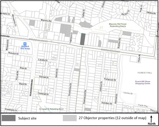
The Site and Surrounds
The subject site is located on the
north side of Canterbury Road in Blackburn, approximately 320 metres east of
the intersection with Blackburn Road and 1.1 kilometres west of intersection
with Springvale Road. The Forest Hill Chase Shopping Centre is located on
Canterbury Road, approximately 250 metres to the east of the site.
The site has a total site area of
1,457 square metres with a frontage of 20.534 metres to Canterbury Road and a
maximum depth of 71.27 metres. The site maintains a moderate slope of
approximately 3 metres from front (south) to rear (north) and is encumbered by
a 2.44 metre wide drainage easement located along the eastern boundary of the
property.
The site currently contains a detached,
single storey brick dwelling with a pitched tile roof, located towards the rear
of the site, as well as a number of detached outbuildings and in-ground
swimming pool. The site is accessed via an existing crossover located centrally
to the frontage, with a gravel permeable driveway into Canterbury Road.
The Masons Road Flood Retarding
Basin adjoins the site to the immediate north (rear) comprising a significant
open space area running from Lagoona Court in the west to Forest Road in the
east. The Masons Road Flood Retarding Basin contains a significant number
of indigenous plant species and canopy trees.
The surrounding properties are
residential in nature comprising of single and double storey dwellings set on
large allotments with the majority of these containing relatively substantive
canopy trees and canopy coverage.
The arborist report prepared for
the applicant by Tree Space in July 2019 provides an assessment of fourteen
(14) trees. Of these eleven (11) trees are located within the subject site, and
these are mainly of good health and fair structure. Two trees are in excess of
20 metres in height which are as follows:
· Tree 1 - Corymbia maculata (Spoted Gum)
– 27 metres in height, 20+ years ULE, located within the site frontage.
· Tree 12 - Eucalutpus tricarpa (Red Iron
Bark) – 20 metres in height, 20+ years ULE, located within the site
frontage.
Three (3)
canopy trees are located on adjoining residential properties. Most notably
there is a well-established Eucalyptus botryoides (Southern Mahogany)
located within the south-western quadrant of No. 203 Canterbury Road.
Trees numbered 1, 2, 3 (adjoining
property), 4, 5, 6, 7, 8, 9, 10 (adjoining property), 12 and 13 (adjoining
property) are protected under the Significant Landscape Overlay- Schedule
2. A table summarising the affected trees on the subject site and
adjacent lots are included under the Planning Controls heading below.
Planning Controls
The proposal triggers the need for
a Planning Permit under the following clauses of the Whitehorse Planning
Scheme:
Neighbourhood Residential Zones
(Schedule 1)
Pursuant to Clause 32.09-2
(Neighbourhood Residential Zone) a permit is required to use land for the
purpose of a medical centre.
Significant Landscape Overlay
(Schedule 2)
Pursuant to Clause 42.03:
· A
permit is required to remove, destroy or lop a tree (subject to exemptions);
· A
permit is required to construct a front fence that is within 4 metres of any
protected vegetation (subject to exemptions); and
· A
permit is required to construct or carry out buildings and works (subject to
exemptions).
The proposal impacts protected trees as summarised in the
table below:
|
Tree No.
|
Botanical Name
|
Common Name
|
Height
|
Trigger under SLO2
|
|
1
|
Corymbia maculata
|
Spotted Gum
|
27m
|
Removal
|
|
2
|
Pittosporum undulatum
|
Sweet Pittosporum
|
6m
|
Removal
|
|
3
|
Eucalyptus leucoxylon
|
Yellow Gum
|
7m
|
Buildings and works within 4m (adjoining property)
|
|
4
|
Eucalyptus botryoides
|
Southern Mahogany
|
9m
|
Removal
|
|
5
|
Eucalyptus floribunda
|
Rough Barked Apple
|
5m
|
Buildings and works within 4m
|
|
6
|
Eucalyptus botryoides
|
Southern Mahogany
|
12m
|
Buildings and works within 4m
|
|
7
|
Eucalyptus botryoides
|
Southern Mahogany
|
14m
|
Buildings and works within 4m
|
|
8
|
Pittosporum undulatum
|
Sweet Pittosporum
|
4m
|
Buildings and works within 4m
|
|
10
|
Eucalyptus botryoides
|
Southern Mahogany
|
22m
|
Buildings and works within 4m (adjoining property)
|
|
12
|
Eucalyptus tricarpa
|
Red Ironbark
|
20m
|
Buildings and works within 4m
|
|
13
|
Lophostemon confertus
|
Brush Box
|
12m
|
Buildings and works within 4m (adjoining property)
|
|
14
|
Lophostemon confertus
|
Brush Box
|
5m
|
Removal
|
Schedule 2 to the Significant Landscape Overlay, as well as
triggers for impacts to vegetation, sets out a number of permit triggers for
buildings and works,
The following triggers are relevant to the current application
|
Permit
trigger
|
Proposal
|
|
The building
is no higher than two storeys or 9 metres.
|
The new building
addition is no higher than two storeys or 9 metres.
No permit required.
|
|
The building
is set back at least 9 metres from the front boundary for a single storey
building or 11 metres for a two-storey building.
|
The new building
addition is setback in addition of 11 metres from street frontage.
No permit required.
|
|
The building (except for
a garage) is set back at
least 1.2 metres from any other boundary for a building wall height of no
more than 3.6 metres or 1.5 metres plus half the building wall height if the
building wall height is more than 3.6 metres
|
The new building
addition is setback 1.2 metres from the side boundary.
No permit required.
|
|
The building is less
than 33 per cent of the site
area at ground level and 25 per cent of the site area at first floor level,
excluding hard surfaces and impervious areas.
|
The building (inclusive
of addition) is less than 33 per cent of the site area.
No permit required.
|
|
Hard surfaced
and impervious areas (including tennis courts and swimming pools, but
excluding buildings) are less than 17 per cent of the site area.
|
Hard
surfacing and impervious areas (excluding buildings) exceed 17 per cent of the
site area
Permit required.
|
|
The total
area of all buildings and hard surfaces and impervious areas (including
tennis courts and swimming pools are less than 50 per cent of the site area.
|
The total area of all
buildings and hard surfaces exceeds 50 per cent of the site area.
Permit required.
|
Road Zone, Category 1
Pursuant
to Clause 52.29 (Land Adjacent to a Road Zone, Category 1) a permit is required
to create or alter access to a road in a Road Zone, Category 1.
PROPOSAL
The application proposes the use of
the land for a medical centre, the extension to the existing building, the
provision of hard-stand for car parking, the removal of trees from the site,
other buildings and works and associated landscaping.
Use
The application seeks to convert
the existing dwelling into a medical centre, comprising of four practitioners
at any given time, as well as two receptionists. The medical centre will
operate Monday to Friday 9:00am to 6:00pm and Saturday and Sunday 9:00am to
1:00pm.
The medical centre will provide
general physician services, as well as offering on site specialist services.
Buildings and Works
The application proposes a variety
of buildings and works across the site, including:
· Alterations
and additions to the existing building, including the provision of an exercise
and physiotherapist room; a ramp and refined entry point and internal
alterations to cater for the proposed medical centre land use;
· The
provision of 12 car parking spaces (including two disabled spaces) to the site
frontage and rear, with associated access way and turning areas;
· The
provision of a bicycle parking space to the northern side of the building; and
· The
provision of a permeable pedestrian pathway and timber sleeper retaining wall
to the eastern side of the building. The application seeks to retain the
existing swimming pool at the rear of the site.
The proposed works maintain
existing building setbacks from the site frontage, with the northern boundary
hard stand being located 7.62 metres from the frontage; the southern boundary
hardstand being located 19.81 metres from the frontage and the proposed
building extension being 27.87 metres from the frontage.
Tree Removal and Landscaping
The application proposes the
removal of four (4) trees from the site, each requiring a planning permit for
removal under the Significant Landscape Overlay – Schedule 2. The trees
are nominated as follows:
· Tree
01 – Corymbia maculata
· Tree
02 – Pittosporum undulatum
· Tree
04 – Eucalyptus botryoides
· Tree
14 – Lophostemon confertus
The application proposes revegetation of the site through
the provision of significant canopy and shrubbery landscaping. This includes a
number of large trees with established heights in excess of 15 metres as well
as some small and medium height shrubbery with established heights between 1
metre and 3 metres at maturity.
CONSULTATION
Public Notice
This application was advertised on
12 June 2019, following which a total of twenty six (26) objections were
received. The objections raised issues relating to:
· Removal
of vegetation,
· Landscaping
opportunities,
· Extent
of hard paving,
· Traffic
and parking impacts; and
· Lack
of consistency with the Significant Landscape Overlay – Schedule 2.
A Consultation Forum was held on
30th July 2019 and chaired by Councillor Munroe, at which the issues were
explored, however no resolution was reached between the parties.
Following this, a Section 57A
amendment to the application was lodged on 16th October 2019 which sought to
address recommendations made by Council’s arborist and concerns raised by
Council’s transport department. The Section 57A amendment and relevant
documentation was renotified to affected parties with one (1) additional
objection and further submissions from existing objectors. The additional objection
and further submissions received did not raise additional issues from those
originally raised however expressed significant concern toward the proposed
removal of Tree 1.
Following completion of
re-notification it was identified that the application did not seek approval
for use of land for the purpose of a medical centre and as such a further
Section 57A Amendment to the application was lodged on 11 February 2020 which
sought to amend application so as to allow for use of land for the purpose of a
medical centre and a greater landscape response. The Section 57A amendment and
relevant documentation and relevant documentation was renotified to affected
parties with two (2) additional objections and further submissions received,
taking the total number of objections received against application to
twenty-nine (29) objections.
Referrals
External
VicRoads
No objections, subject to planning
permit conditions
Internal
Transport
No objections, subject to planning
permit conditions
Planning Arborist
No objections, subject to planning
permit conditions
DISCUSSION
Clause 71.02-3 recognises that
planning aims to meet the needs and expectations of societies by addressing
aspects of economic, environmental and social wellbeing affected by land use
and development.
Planning and responsible
authorities should endeavour to integrate the range of planning policies
relevant to the issues to be determined and balance conflicting objectives in
favour of net community benefit and sustainable development for the benefit of
present and future generations.
The application has been assessed
against the relevant objectives of the Planning Policy Framework and on
balance, with consideration of all relevant policies and provisions, plus
objectives received through the notification period, is considered to respond
appropriately to the key objectives within the policy context.
Consistency with Planning Policy
Framework and Local Planning Policy Framework
Planning
Policy Framework
The
policy at Clause 11.01-1S (Settlement) seeks to promote sustainable growth and
development of Victoria and deliver choice and opportunity for all Victorians
through a network of settlements. To achieve this objective, the policy has
developed strategies that seeks to promote and capitalise on opportunities for
urban renewal and infill redevelopment as well as ensure retail, office-based
employment, community facilities and services are concentrated in central
locations.
Important
to this application are the objectives of Clause 12.05-2S (Landscapes) which
seek to protect and enhance significant landscapes and open spaces that
contribute to character, identity and sustainable environments. To achieve this
objective, the policy has developed strategies that seek to ensure that
development does not detract from the natural qualities of significant
landscape areas and recognise the natural landscape for its aesthetic value and
as a fully functioning system.
The
retention of existing trees and additional canopy planting proposed around the
sites front and rear setback areas improves upon the landscape value attributed
to the site and surrounds recognised under Clause 12.05-2S and the Significant
Landscape Overlay.
Clause
15.01-1S (Urban Design) and Clause 15.01-2S (Building Design) both seek to
ensure that the built environment contributes positively to the local context
and public realm. Important to this objective are strategies that seek to
protect sensitive environs from inappropriate development, and encourage new
development to retain existing vegetation.
Clause
17.01-1S (Diversified Economy) seeks to strengthen and diversify the economy by
facilitating growth in a range of employment sections, which includes health as
well as improving access to jobs closer to where people live.
At a
local level, the proposal responds to the policy objectives at Clause 17.01-1S
by facilitating growth in the health sector and providing potential local job
opportunities for the municipality.
Clause
18.02-4S (Car Parking) seeks to ensure an adequate supply of car parking that
is appropriately design and located. This is of particular importance for this
application, noting that the car park must be designed to minimise the impact
of existing vegetation whilst provide an adequate supply of spaces that are
safe and efficient to manoeuvre.
The
proposal seeks to supply the required number of car parking spaces on the site
in association with a medical centre, meeting the objective of Clause 18.02-4S.
Finally,
Clause 19.02-1S (Health Facilities) seeks to assist the integration of health
facilities with local and regional communities. To achieve this objective, the
policy has developed strategies that seek to facilitate the location of health
and health-related facilities taking into account demographic trends, the existing
and future demand requirements and the integration of services into communities
as well as provide adequate car parking for staff and visitors of health
facilities.
The
proposal seeks to provide health services through the provision of a medical
facility along a key arterial road (Canterbury Road), improving access to
health facilities within the local community in accordance with Clause
19.02-1S.
Local
Planning Policy Framework
The
Strategic Framework Plan at Clause 21.04 (Strategic Directions) of the Municipal
Strategic Statement (MSS) identifies the site and its surrounds as being within
a ‘significant landscape area’
Clause
21.05 (Environment) sets out a number of strategies in respect of the
environment. Amongst others, these seek to ensure that development is of
a high quality design that is compatible with the character of the area;
adequate open space and landscaping is provided for new development; and that
upper canopy trees are planted to enhance the character. Appropriate
development which responds to environmental characteristics is encouraged.
The
MSS addresses non-residential uses at Clause 21.06-7 (Non-Residential
Uses). The key issues include ensuring development is designed in a
manner which integrates the use and the built form into the residential
environment, and ensuring there is no detriment to the community or surrounding
residential amenity. The objectives refer to buildings integrating with
and respecting the surrounding neighbourhood character. A related strategy
is to apply the Neighbourhood Character Precinct Brochures with Preferred
Character Statements and Design Guidelines to provide guidance for future
non-residential development in residential areas
The Whitehorse Neighbourhood
Character Study (2014) includes the site within a Bush Environment
Precinct. The preferred character statement for this precinct reads:
The streetscapes will be dominated by vegetation with
subservient buildings frequently hidden from view behind vegetation and tall
trees. The buildings will nestle into the topography of the landscape and be
surrounded by bush-like native and indigenous gardens, including large
indigenous trees in the private and public domains. Buildings and hard surfaces
will occupy a very low proportion of the site. They will be sited to reflect
the prevailing front, rear and side setbacks. The larger rear setbacks will
accommodate substantial vegetation including large canopy trees. The bushy
environs are complemented by a lack of front fencing and street trees.
Properties abutting and close to creeks and lake environs will contain more
indigenous trees and shrubs that act in part as wildlife corridors. This
precinct is identified for the lowest scale of intended residential growth in
Whitehorse (Limited Change area) and the preservation of its significant
landscape character and environmental integrity is the highest priority
The Tree
Conservation Policy at Clause 22.04 (Tree Conservation) in its objectives refer
to minimising the loss of significant trees; ensuring new development does not
detract from the natural environment and ecological systems; and promoting the
regeneration of tall trees through the provision of adequate open space and
landscaping areas in new development. Policy and performance standards in
respect of tree retention and tree regeneration are provided within the Clause
and will be discussed within the assessment section of this report.
The
removal of Tree 1, has been assessed as acceptable on the basis that it results
in an improved car parking layout; improved area for substantial planting and
lastly the retention of tree 12, which is considered to offer moderate amenity
value and achieves the objectives outlined under Clause 22.04. It is this
balance between tree retention, appropriate buildings and works and replanting
that the Clause seeks to achieve.
Direction
for non-residential uses in the municipality’s residential areas is
provided at Clause 22.05 (Non-Residential Uses in Residential
Areas). The objectives of this policy are:
· To
make provision for services and facilities demanded by local communities in a
way that does not detract from the amenity of the area.
· To
avoid the concentration of non-residential uses where it would:
o Have
off-site effects which are detrimental to residential amenity.
o Create
a defacto commercial area.
o Isolate
residential properties between non-residential uses.
o To
ensure that the design, scale and appearance of non-residential premises
reflects the residential character and streetscape of the area.
o To
ensure that the location of the use is appropriate to the role and function of
the road network and that adequate provision is made for onsite car parking.
The
significant front and rear setbacks proposed on the site maintain a sense of
spaciousness around the periphery of the site, ensuring that the building
responds positively to the existing low-scale context of the ‘bush
environs’ precinct whilst providing opportunity for substantial planting,
all in accordance with the policy provisions of Clause 22.05.
Upon maturity the proposed tree
canopy, together with the existing tree canopy, will create a native bushland
garden setting and soften the built form from the streetscape, achieving
consistency with Clause 21.06-4, Clause 22.04 and Clause 22.05 by meeting the
preferred character statement which seeks to hide building form behind
vegetation and tall trees, ensuring that visual amenity impacts to the street
are mitigated.
Buildings and Works
The
proposal includes various works associated with the medical centre land use on
the site.
The works specifically include the following:
· Alterations
and additions to the existing building, including the provision of an exercise
and physiotherapist room; a ramp and refined entry point and internal
alterations to cater for the proposed medical centre land use;
· The
provision of 12 car parking spaces (including two disabled spaces) to the site
frontage and rear, with associated access way and turning areas;
· The
provision of a bicycle parking space to the northern side of the building; and
· The
provision of a permeable pedestrian pathway and timber sleeper retaining wall
to the eastern side of the building.
Overall,
it is considered that the works proposed are suitable for the site within the
SLO2, with the building maintaining a significant front setback from the
frontage and inconspicuous profile due to the contemporary form and single
storey height of the proposed extension to limit dominance within the existing
landscaping setting.
The
proposed access way and car parking area within the site frontage and rear has
been sited appropriately to minimise impact to vegetation where possible, with
the removal of three (3) trees from the frontage only. Whilst this includes the
removal of a large Corymbia maculata (identified as a Corymbia citriodora by
the Blackburn and District Tree Preservation Society Inc.), this is not
considered unreasonable as it allows for the retention of the mature Eucalyptus
tricarpa. Further, the replanting response as demonstrated within the landscape
plan includes the provision of significant canopy replacement across the site
within well-proportioned setback areas to improve growth to maturity.
Whilst
the proposed car parking and access way exceeds the minimum permit trigger
threshold for permeability, this is not considered unreasonable on the basis
that the spaces are sited to avoid excessive dominance to the streetscape and
to the rear boundary interface with the retarding basin.
The impact of tree removal and proposed landscaping will be discussed
separately below.
Tree Removal
The application proposes the
removal of three trees from the site, each requiring a planning permit for
removal under the SLO2. The trees are nominated as follows:
· Tree
01 – Corymbia maculata;
· Tree
02 – Pittosporum undulatum
· Tree
04 – Eucalyptus botryoides
· Tree
14 – Lophostemon confertus
The specific details of each tree (based on the submitted
arborist report) is identified below:
|
Tree
|
Botanical
name
|
DBH
(cm)
|
Height
(m)
|
Canopy
Width
|
Age / ULE
|
Health
|
Structure
|
Condition/
Description
|
Amenity
value
|
|
1
|
Corymbia
maculate
(Spotted
gum)
|
76
|
27m
|
10m
|
Mature
20+
|
Good
|
Good/fair
|
Irregular
form. Numerous large failures.
|
High-Moderate
|
|
2
|
Pittosporum
Undulatum
(Sweet
Pittosporum)
|
37
|
6m
|
8m
|
Mature
0
|
Good
|
Fair
|
Self-seeded
weed species located beside west boundary and Tree 1 within site.
|
Low
|
|
4
|
Eucalytpus
botryoides
(Southern
Mahogany)
|
51
|
9m
|
6m
|
Over-mature
1-5
|
Fair
|
Poor
|
Poorly formed tree with numerous failures located
beside entry.
|
Medium
|
|
14
|
Lophostemon
confertus
(Brush
Box)
|
20
|
5m
|
3m
|
Semi-mature
20+
|
Good
|
Good
|
Centrally located within the site adjacent to
northern side of dwelling.
|
Moderate
|
These trees are all located within
the site frontage, and required for removal due to the works proposed for the
car park and access way. Trees 2 and 4 are not considered to be of high amenity
value, and are much smaller in height and spread, thus not providing a density
in foliage that would enhance or form part of the significant landscape
character of the wider area and streetscape setting.
Tree 1 however is of particular
significance due to its high-moderate amenity value, 27m height and 10m spread.
Tree 1 is a native species that forms part of the significant landscape
character of the wider area and streetscape setting.
Council’s arborist has noted
that tree 1 has experienced large tree failures in the past resulting in a top
heavy structure with a portion of the upper canopy being made up of epicormic
growth. It is further explained that the epicormic growth will increase the
likelihood of branch failures and together with the encroachment into the TPZ,
will only further increase risk associated with retention.
Council’s arborist has
recommended greater effort should be placed into protecting tree 12, a
Eucalyptus tricarpa, with a height of 20m and spread of 13m, and moderate
amenity value. It has been suggested that with an appropriate layout, this tree
could last for a period of 30+ years, providing ongoing character and
ecological benefits.
Officers recognise and acknowledge
that Tree 1 is of particular significance to objectors, and this has been
strongly stated in submissions. It is further acknowledged that the retention
of this tree would be preferable if it were of a health and structure that
enabled its long term growth and retention. In this circumstance, officers, on
arboricultural advice, also consider that tree 12 offers the greater long term
landscape impact and efforts to ensure its retention outweigh the ability to
retain Tree 1, given its assessment rating.
With the provision of additional
replanting and growth, this is considered an appropriate outcome that achieves
consistency with the landscape character outcomes sought under the Significant
Landscape Overlay (Schedule 2) for vegetation density and protection of
habitat.
Landscaping
As described above, the application proposes a number of
replacement canopy trees across the site. The table below indicates the tree
species proposed for the site, including the quantity and mature height and
spread, taken from the proposed landscape plan:
At the frontage, the two (2) Acacia
melanoxylon (Blackwood) trees proposed are considered to be adequate
replacement trees with mature height of up to 15 metres, which is generally
consistent with the height and scale of the Eucalyptus tricarpa tree proposed
to be retained as well as others within the streetscape of Canterbury Road at
maturity. Notwithstanding this and to ensure an even greater species diversity,
a condition will be placed on permit requiring the provision of at least two
(2) Silver-leafed Stringybarks, (Eucalyptus cephalocarpa) which are native to
the Blackburn area, in place of two (2) of the four (4) Lightwoods (Acacia
implexa) proposed to be planted.
At the rear, the two (2) Eucalyptus
radiata (Narrow Leaved Peppermint) and one (1) Elaeocarpus reticulatus (Dwarf
Blueberry Ash) proposed are appropriate canopy additions where there was
previously no significant landscaping at the rear of the site. These
trees are located to form a nexus between the site and abutting retarding
basin, creating a distinct spine of open space with native species. The
proposed trees maintain a consistent height and scale to those within the
retarding basin to form a distinct canopy view line from the Canterbury Road streetscape
at maturity.
In addition to the larger sized
canopy trees, the proposal also affords a number of other tree species such as
the Lightwood or Bottlebrush, with an understorey layer of small to medium
sized shrubbery. These are all located within well-proportioned setback areas,
to improve growth to maturity.
The proposal meets the tree density
guideline under the Significant Landscape Overlay, with 9 trees over 15 metres
in height required and 10 trees over 15 metres provided. Whilst it is noted
that not all trees are proposed to be planted within an area that is capable of
providing for a planting envelope of 50sqm as sought under Clause 22.04 of the
Whitehorse Planning Scheme, the landscape plan provides for a well-designed
bushland environment with adequate planting envelopes provided throughout the
site and a planting scheme that significantly improves the existing landscaping
and tree canopy on site.
Car Parking and Road Zone Access
Pursuant to Clause 52.06-5, the car
parking rate for a medical centre located within the Principal Public Transport
Network is 3.5 spaces to each 100sqm of leasable floor area. As such, a total
of 8 car parking spaces are required, with a total of 12 provided on the site
(including the provision of two DDA compliant disabled spaces). The proposal
exceeds the minimum requirement for car parking under Clause 52.06, and no
planning permit is required.
Council’s Transport Engineers
have reviewed the submitted plans and assessed that compliance is achieved with
the design standards outlined at Clause 52.06-9, ensuing that vehicles can
appropriately manoeuvre through the site and enter / exit in a forwards
direction.
The provisions of Clause 52.29
applies to land adjacent to a Road Zone, Category 1. The purpose outlined at
Clause 52.29 is nominated as follows:
· To
ensure appropriate access to identified roads.
· To
ensure appropriate subdivision of land adjacent to identified roads.
A permit is required to create or
alter access to a road in a road zone, category 1. In Peninsula Blue
Developments Pty Ltd v Frankston CC, VCAT considered that clause 52.29 not
only applied to a physical change to access, but also to any change to the use
or development that may result in changes to the opportunity for traffic to
approach or enter the road differently.
This has been a long-standing
precedence that is still currently applicable. Whilst the application does not
seek to physically alter the current site access, the change in opportunity for
traffic to approach or enter the site in terms of volume and frequency due to
the proposed medical centre use triggers consideration and thus a planning
permit pursuant to Clause 52.29.
The alteration to the site access
resultant from the proposal has been reviewed by VicRoads, with no concerns
raised subject to planning permit conditions.
CONCLUSION
The proposal for Use and
Development of Land for the Purpose of a Medical Centre, Removal of Vegetation
and Alteration of Access to a Road in a Road Zone, Category 1 is an acceptable
response that satisfies the relevant provisions contained within the Whitehorse
Planning Scheme, including the Planning Policy Framework, Local Planning
Policies and the Significant Landscape Overlay – Schedule 2.
The application is consistent with
the relevant objectives and Decision Guidelines of clauses 22.04 and 42.03. The
trees to be removed have been assessed as acceptable for removal based on poor
health, structure or amenity value, noting that the loss of Tree 1 will have an
impact on how the site presents to Canterbury Rd. The proposal seeks to
maintain other significant vegetation on the site, with adequate replanting of
large canopy trees, ensuring that the proposal will contribute in the medium to
longer term to the existing landscape setting of the bush environment area.
A total of twenty-nine (29)
objections were received as a result of public notice and all of the issues
raised have been discussed in the report as required.
It is considered that the application
should be approved.
Attachment
1 Architectural
Plans 
2 Landscape Plans

Council Minutes 25
May 2020
9.1.2 26-28
Wellington Road, BOX HILL (LOT 1 & 2 LP 1974 4)– Development of the
land for a 17 storey building containing dwellings and ground floor Food and
Drinks Premises (Cafe) and associated buildings and works.
FILE NUMBER: WH/2018/743
ATTACHMENT
SUMMARY
This application was advertised, and a total of 7
objections were received. The objections raised issues with overdevelopment of
the site; traffic impacts; overshadowing; overlooking & loss of privacy;
wind impacts; impact on existing services; noise associated with construction
and glare from building materials. A Consultation Forum was held on 18/12/2019
chaired by Councillor Barker, at which the issues were explored, however no
resolution was reached between the parties. This report assesses the application
against the relevant provisions of the Whitehorse Planning Scheme, as well as
the objector concerns. It is recommended that the application be
supported, subject to conditions.
|
Motion
Moved by Cr Liu, Seconded by Cr Barker
That Council:
A Being the Responsible Authority, having
caused Application WH/2018/743 for 26-28 Wellington Road, BOX HILL (LOT 1
& 2 LP 1974 4) to be advertised and having received and noted the
objections is of the opinion that the granting of a Planning Permit for the Development
of the land for a 17 storey building containing dwellings and ground floor
Food and Drinks Premises (Cafe) and associated buildings and works is
acceptable and should not unreasonably impact the amenity of adjacent
properties.
B Issue a Notice of Decision to Grant a
Permit under the Whitehorse Planning Scheme to the land described as 26-28
Wellington Road, BOX HILL (LOT 1 & 2 LP 1974 4) for the Development of
the land for a 17 storey building containing dwellings and ground floor Food
and Drinks Premises (Cafe) and associated buildings and works subject to the
following conditions:
1. Before the development starts, but excluding
the works detailed in the Early
Works Plan, amended plans must be submitted to and approved by the
Responsible Authority in a digital format. Once approved, the plans
will be endorsed and will then form part of the permit. The plans must
be drawn to scale, with dimensions, and be generally in accordance with the
decision plans but modified to show:
a) The following changes as shown in the
discussion plans from Peddle Thorp Architects dated February, 2020 (Revision
4):
i. Communal laundry facilities located in
Basement level 1;
ii. Provision for informal delivery
arrival/parking areas adjacent to southern laneway;
iii. Communal space at rooftop level amended to
include meeting room space;
iv. HVAC systems provided for levels 10-15;
v. Six electric vehicle parking bays and
associated charging facilities;
vi. Revised colours and materials schedule.
But further modified to show:
b) The northern boundary delineated with a 1.8m
high, visual solid fence;
c) East-facing bedroom windows associated with
the north-western corner of the development treated with fixed, obscure
glazing to a height of 1.7m or otherwise designed to avoid unreasonable
overlooking to the satisfaction of the Responsible Authority;
d) At first floor and above, any north-facing
habitable room windows or balconies located less than 4.5m from the northern
boundary treated with 1.7m high, fixed obscure glazing or other treatments to
avoid unreasonable overlooking to the satisfaction of the Responsible
Authority;
e) At first floor and above, any south-facing
habitable room windows or balconies located less than 4.5m from the center
line of the adjoining laneway treated with 1.7m high, fixed obscure glazing
or other treatments to avoid unreasonable overlooking to the satisfaction of
the Responsible Authority;
f) At first floor and above, any
east-facing habitable room windows or balconies located less than 4.5m from
the eastern boundary treated with 1.7m high, fixed obscure glazing or other
treatments to avoid unreasonable overlooking to the satisfaction of the
Responsible Authority;
g) Balconies to meet the dimensions under
Standard D19 – Private open space at clause 58 of the Whitehorse
Planning Scheme. Any changes required to achieve compliance with this
condition must not result in living room areas which trigger a variation to
Standard D24 – Functional layout to the satisfaction of the Responsible
Authority;
h) No additional overshadowing to the concrete
footpath on the western side of Wellington Road by 10:00am on the 22nd of
September to the satisfaction of the Responsible Authority. The changes to
achieve this outcome must not result in the loss of any communal facilities
from the building;
i) All tandem car parking spaces being
allocated to a single tenancy or dwelling;
j) Detailed drawings, reports or other
material for the north-facing, on-boundary wall to demonstrate a high-quality
outcome which may include, but is not necessarily limited to murals or mosaic
treatments;
k) Any changes required to reflect the approved
Façade Strategy under condition 6 of this permit;
l) Any changes required to reflect the
approved Wind Impact Assessment under condition 9 of this permit;
m) Development plans to reflect all sustainability
features indicated in the submitted amended Sustainability Management Plan
(SMP). Where features cannot be visually shown, include a notes table /
‘ESD Schedule’ providing details of the requirements. The
plans are to be generally in accordance with the plans submitted with the
application but modified to show:
i. Water-sensitive urban design measures
as required to achieve a STORM Rating of at least 100% or equivalent,
including a rainwater tank sufficiently sized, plumbed to all toilets and
laundry areas, as well as, indicative pump and maintenance access shown on
Development Plans.
ii. Design measures as identified in the BESS
Report, as required to exceed an acceptable overall 50% score and exceed the
‘pass’ marks in the categories of Water, Energy Stormwater and
Indoor Environment Quality (IEQ).
iii. Floor plans for all floors.
iv. All operable windows, doors, winter garden
openings and vents in elevation drawings.
v. Include glazing specifications for all
residential glazing, including solar heat gain coefficient (SHGC), visual
light transmittance (VLT) and U-value. Ensure that such values are
consistent with Daylight Modelling, Preliminary Section J / JV3 and
Preliminary NatHERS Energy Efficiency Modelling inputs.
vi. Any exterior building services equipment,
including any heating, cooling, ventilation, hot water and renewable energy
systems.
viii. Include an annotation of the timber species intended for use
as decking or outdoor timber, noting that unsustainably harvested imported
timbers must not be used.
2. The use and development as shown on the
endorsed plans must not be altered (unless the Whitehorse Planning Scheme
specifies that a permit is not required) without the prior written consent of
the Responsible Authority.
Landscaping
3. Before the building is occupied, or by such
later date as approved in writing by the Responsible Authority, the
landscaping works shown on the endorsed Landscape Plan must be carried out
and completed to the satisfaction of the Responsible Authority. The
landscaping shown on the endorsed Landscape Plan must be maintained by:
a) Implementing and complying with the
provisions, recommendations and requirements of the endorsed Landscape Plan;
b) Not using the areas set aside on the endorsed
Landscape Plan for landscaping for any other purpose; and
c) Replacing any dead, diseased, dying or
damaged plants,
to the satisfaction of the Responsible Authority.
Car Park Management Plan
4. Before the development commences, but excluding the works detailed
in the Early Works Plan, a Car Park Management Plan to the satisfaction of
the Responsible Authority must be submitted to and approved by the
Responsible Authority. When approved, the Car Park Management Plan will
be endorsed and will form part of this permit. The Car Park Management
Plan must address, but not be limited to, the following:
a) Parking allocations to demonstrate no
reduction to car parking rates under clause 52.06 or Schedule 1 to the Parking
Overlay under clause 45.09 of the Whitehorse Planning Scheme for the approved
development;
b) Identifying (including number and location)
any tandem parking spaces which must be allocated to a single tenancy or
dwelling;
c) The management of visitor car parking spaces
and security arrangements for occupants of the development, including details
on how residential visitors are to access car parking;
5. The
provisions, recommendations and requirements of the endorsed Car Park
Management Plan must be implemented and complied with to the satisfaction of
the Responsible Authority.
Façade
strategy
6. Prior
to the endorsement of plans under condition 1, a Façade Strategy must
be submitted to and be to the satisfaction of the Responsible Authority. When
approved this will form part of the endorsed plans. All materials, finishes
and colours must be in conformity with the approved Façade Strategy to
the satisfaction of the Responsible Authority. The Facade Strategy for the
development must be generally in accordance with plans prepared by Peddle
Thorp Architect dated June 2019 and detail:
a) A concise description by the architect of the
building design concept and how the façade works to achieve this.
b) Schedule of colours, materials and finishes,
including the colour, type and quality of materials showing their application
and appearance. This can be demonstrated in coloured elevations or renders
from key viewpoints, to show the materials and finishes linking them to a
photographic quality sample board with clear coding.
c) External building materials and finishes not
resulting in hazardous or uncomfortable glare to pedestrians, public
transport operators and commuters, motorists, aircraft, or occupants of
surrounding buildings and public spaces to the satisfaction of the
Responsible Authority;
i. Issues relating to glare and
reflectivity of chosen building materials must be addressed within a report
prepared by a suitably qualified engineer to qualify the outcomes under
condition 6(c) of this permit.
d) Elevation details generally at a scale of
1:50 illustrating typical podium details, entries and doors, typical privacy
screening and utilities, typical tower detail, glazing, soffit details,
window detail and any special features which are important to the building’s
presentation.
e) Cross sections or other method of
demonstrating the façade systems, including fixing details indicating
junctions between materials and significant changes in form and/or material.
f) Information about how the façade
will be accessed and maintained and cleaned, including planting where
proposed.
g) Example prototypes and/or precedents that
demonstrate the intended design outcome indicated on plans and perspective
images to produce a high quality built outcome in accordance with the design
concept.
Sustainability
Management Plan
7. Prior to the endorsement of plans under
Condition 1 of this permit, an amended Sustainability Management Plan to the
satisfaction of the Responsible Authority must be submitted to and approved
by the Responsible Authority. Once approved, the amended Sustainable
Design Assessment will be endorsed and will form part of this permit. The
amended Sustainability Management Plan must be generally in accordance with
the Sustainability Management Plan prepared by Sustainable Built Environments
and dated 24/6/2019, but modified to include, show or address:
a) A STORM Rating Report or equivalent with a
score of at least 100% or equivalent.
b) A complete, published BESS Report, with an
acceptable overall score that exceeds 50% and exceed the ‘pass’
marks in the categories of Water, Energy Stormwater and Indoor Environment
Quality (IEQ).
c) Provide Preliminary NatHERS Assessments for
10% of the total amount of dwellings a part of the development.
d) Preliminary NatHERS performance to indicate
that maximum cooling loads are ≤ 21 MJ/m2/annum per dwelling.
e) Preliminary BCA Section J / JV3 modelling
indicating a commitment to achieve at least a 10% improvement on minimum
energy efficiency requirements with respect to non-residential areas.
f) Provide glazing specifications
including SHGC, VLT and U-values and ensure that such values are consistent
with Daylight Modelling, Preliminary Section J / JV3 and Preliminary NatHERS
Energy Efficiency Modelling inputs, as well as, Development Plans.
g) Control car park ventilation with CO sensors.
h) Control car park lighting (at least 75% of
lighting fixtures) with motion sensors.
i) Commit to controlling all common,
service and lift area lighting with sensors/timers.
j) Commit to controlling common, service
and lift area ventilation with sensors/timers.
k) Commit to the inclusion of improved energy
efficient heating, cooling and hot water systems indicating the associated
COP and EER values and star ratings.
l) Commit to the inclusion of water
efficient fixtures and appliances indicating the associated WELS ratings.
m) Connect the rainwater tanks to 50% of toilet
flushing systems (approximately 130 bedrooms and all non-residential areas)
throughout the development.
n) Commit to diverting at least 80% of
construction/demolition waste from landfill.
o) Submit a water balance calculation
considering integrated water management which justifies the rainwater tank
capacity, based on long-term average rainfall data, collection areas and expected
end uses, which is in compliance with AS/NZS 6400:2016 of 1 full- and 4
half-flushes per person per day (providing 17.5 L/person/day for a 4 star
WELS rated toilet).
i. Rainwater tank size must be selected
based on calculations, ensuring adequate reliability of supply is maintained
with respect to managing potential overflow and considering the
development’s potable water demand, as well as, facilitating
requirements for on-site detention to control peak discharge and flow.
The rainwater tank must cater for at least 50% of toilet flushing systems
– approximately 130 bedrooms and non-residential systems.
8. The provisions, recommendations and
requirements of the endorsed Sustainability Management Plan must be
implemented and complied with to the satisfaction of the Responsible
Authority.
Wind impact assessment
9. Prior to the endorsement of plans under
Condition 1 of this permit, a Wind Assessment Report to the satisfaction of
the Responsible Authority must be submitted to and approved by the Responsible
Authority. Once approved, the amended Wind Assessment Report will be
endorsed and will form part of this permit. The report must include
Wind tunnel testing to demonstrate the approved design achieving:
a) Walking comfort along Wellington Road and the
adjoining laneway;
b) Standing comfort at relevant entrances along
Wellington Road;
c) Sitting comfort at where seating is or
intended to be provided – particularly at the retail tenancy food and
drink area at ground floor;
10. The recommendations within the Wind
Impact Assessment Report must be implemented to the satisfaction of the
Responsible Authority such that:
a) There is no cost to the Responsible
Authority.
b) There is no reliance on the provision of
street trees for wind mitigation.
c) There is no reliance on the provision of
baffles on public land, except where all appropriate approvals have been
obtained from all relevant authorities and land managers and approval also
granted by the Responsible Authority.
11. The provisions, recommendations and requirements
of the endorsed Wind Assessment Report must be implemented and complied with
to the satisfaction of the Responsible Authority.
Lighting plan
12. Before the development commences, a Public
Lighting Plan to the satisfaction of the Responsible Authority must be
submitted to and approved by the Responsible Authority. The Public
Lighting Plan must address lighting along the southern adjoining laneway
between Wellington Road and the south-eastern corner of the subject site.
When approved, the Public Lighting Plan will be endorsed and will form part
of this permit. The Public Lighting Plan must provide for:
a) Lighting to the adjoining laneway for the
length of the subject site;
b) A lighting scheme designed for both public
highway and new open public area/road/open space within the curtilage of the
property that complies with uniformity requirements as per standard
AS1158.3.1;
c) The control of light spillage into the
windows of existing and proposed residences to comply with the requirements
of AS 4282 – 1997,” Control of the obtrusive effects of outdoor
lighting”;
d) Lighting to all pedestrian access points to a
residential property to satisfy at least level P4 as per AS 1158.3.1;
e) A maintenance regime for the lighting scheme
within the curtilage of the property.
f) The use of energy efficient luminaries
and/or solar lighting technologies to reduce carbon emission if possible.
13. The provisions, recommendations and requirements
of the endorsed Public Lighting Plan must be implemented and complied with at
no cost to Council and to the satisfaction of the Responsible Authority.
Waste
Management Plan
14. Before the development commences, a Waste
Management Plan to the satisfaction of the Responsible Authority must be
submitted to and approved by the Responsible Authority. Once approved,
the Waste Management Plan will be endorsed and will form part of this permit.
Use
conditions
15. Except with the prior written consent of the
Responsible Authority the Food and drinks premises authorised by this permit
may only operate between the hours of 7:00am to 10:00pm – Monday to
Sunday.
16. The amenity of the area must not be detrimentally
affected by the use or development, including through:
a) The transport of materials, goods or
commodities to or from land;
b) The appearance of any buildings, works or
materials;
c) The emission of noise, artificial light,
vibration, smell, fumes, smoke, vapour, steam, soot, ash, dust, waste water,
waste products, grit or oil, or
d) The presence of vermin;
to the satisfaction
of the Responsible Authority.
17. The use must comply at all times with the State
Environment Protection Policy – Control of Noise from commercial,
Industry and Trade (SEPP N-1).
General
conditions
18. Before the development is occupied, or by such
later date as approved in writing by the Responsible Authority, all screening
and other measures to prevent overlooking as shown on the endorsed plans must
be installed to the satisfaction of the Responsible Authority. Once
installed the screening and other measures must be maintained to the
satisfaction of the Responsible Authority.
19. The development must be provided with external
lighting capable of illuminating access to each the basement ramp and
pedestrian areas at ground floor. Lighting must be located, directed and
shielded and of limited intensity that no nuisance or loss of amenity is
caused to any person within and beyond the site.
20. The Applicant/Owner must be responsible to meet
all costs associated with reinstatement and/or alterations to Council or
other Public Authority assets deemed necessary by such Authorities as a
result of the development. The Applicant/Owner shall be responsible to
obtain an “Asset Protection Permit” from Council at least 7 days
prior to the commencement of any works on the land and obtain prior specific
written approval for any works involving the alteration of Council or other
Public Authority assets.
21. Treatments to prevent overlooking must not include
‘Translucent film’ on windows and must be generally in line with
the treatments under Standard B22 – Overlooking of Clause 55.
22. Prior to the occupation of the development, all
boundary walls must be constructed, cleaned and finished to the satisfaction
of the Responsible Authority.
23. Before the buildings are occupied, or by such
later date as approved in writing by the Responsible Authority, any redundant
vehicular crossing must be demolished and re-instated as standard footpath
and kerb and channel:
a) At the permit holder's cost; and
b) To the satisfaction of the Responsible
Authority.
24. All pipes, fixtures, fittings and vents servicing
any building on the land must be concealed in service ducts or
otherwise hidden from view to the satisfaction of the Responsible Authority.
25. Except with the prior written consent of the
Responsible Authority, council assets must not be altered in any way.
26. Existing street trees must not be removed or
damaged except with the written consent of the Responsible Authority.
27. The subject land must be drained to the
satisfaction of the Responsible Authority.
28. All stormwater drains and on-site detention
systems are to be connected to the legal point of discharge to the
satisfaction of the Responsible Authority prior to the occupation of the
building/s. The requirement for on- site detention will be noted on
your stormwater point of discharge report, or it might be required as part of
the civil plans approval.
29. Detailed stormwater drainage and/or civil design
for the proposed development are to be prepared by a suitably qualified civil
engineer and submitted to the Responsible Authority for approval prior to
occupation of the development. Plans and calculations are to be
submitted with the application with all levels to Australian Height Datum
(AHD). All documentation is to be signed by the qualified civil
engineer.
30. Stormwater that could adversely affect any
adjacent land shall not be discharged from the subject site onto the surface
of the adjacent land.
31. Prior to works commencing the Applicant/Owner is
to submit design plans for all proposed engineering works external to the
site. The plans are to be submitted as separate engineering drawings
for assessment by the Responsible Authority.
Early
works plan
32. Except with the prior written consent of the
Responsible Authority, prior to the commencement of any buildings and works,
an Early Works Plan must be prepared to the satisfaction of the Responsible
Authority. The Early Works Plan must provide details of all works which
comprise the ‘early works’, including but not limited to:
a) Piling works (Bored Piers), including Capping
Beams;
b) Retention system including structural
columns, shotcrete walls and rock anchors;
c) Bulk excavation;
d) Detailed excavation;
e) Excavation and pouring of pad footings, pile
caps and basement slabs;
f) Civil drainage retention system; and
g) Crane pad footing system.
Green Travel Plan
33. Before the development commences, but excluding
the works detailed in the Early Works Plan, A Green Travel Plan to the
satisfaction of the Responsible Authority must be submitted to and approved
by the Responsible Authority. When approved, the Green Travel Plan will be
endorsed and will form part of this permit. The Green Travel Plan must
include, but not be limited to the following:
a) Information for residents and visitors about
public transport options in the area;
b) Measures to encourage uptake of public
transport to and from the approved development.
Construction Management
34. Prior to the commencement of buildings or works on
the land, a Construction Management Plan, detailing how the owner will manage
the environmental and construction issues associated with the development,
must be submitted to and approved by Council.
The
Construction Management Plan must be prepared and managed by a suitably
qualified person who is experienced in preparing Construction Management
Plans in accordance with the City of Whitehorse Construction Management Plan
Guidelines.
When
approved the Construction Management Plan will form part of this permit and
must be complied with, to the satisfaction of the Responsible Authority, to
the extent that this is in the control of the owner of the land. The owner of
the land is to be responsible for all costs associated with the works to be
undertaken in accordance with the requirements of the Construction Management
Plan
35. The provisions, recommendations and requirements
of the endorsed Construction Management Plans must be implemented and
complied with to the satisfaction of the Responsible Authority.
Expiry
36. This permit will expire if one of the following
circumstances applies:
a) The development is not commenced within three
(3) years from the date of issue of this permit;
b) The development is not completed within five
(5) years from the date of this permit;
c) If the approved use is not commenced within
five (5) years from the date of this permit.
The
Responsible Authority may extend the periods referred to in Condition 35 if a
request is made in writing before the permit expires or within six months
afterwards for commencement or within twelve months afterwards for
completion.
C Has
made this decision having particular regard to the requirements of Sections
58, 59, 60 and 61 of the Planning and Environment Act 1987.
|
|
AMENDMENT
Moved by Cr Bennett, Seconded by Cr
Davenport
That Council:
A.
Being the Responsible Authority, having caused Application WH/2018/743
for 26-28 Wellington Road, BOX HILL (LOT 1 & 2 LP 1974 4) to be
advertised and having received and noted the objections is of the opinion
that the granting of a Planning Permit for the Development of the land for a
17 storey building containing dwellings and ground floor Food and Drinks
Premises (Cafe) and associated buildings and works is acceptable and should
not unreasonably impact the amenity of adjacent properties.
B.
Issue a Notice of Decision to Grant a Permit under the Whitehorse
Planning Scheme to the land described as 26-28 Wellington Road, BOX HILL (LOT
1 & 2 LP 1974 4) for the Development of the land for a 17 storey building
containing dwellings and ground floor Food and Drinks Premises (Cafe) and
associated buildings and works subject to the following conditions:
1.
Before the development starts, but excluding
the works detailed in the Early Works Plan, amended plans must be submitted
to and approved by the Responsible Authority in a digital format. Once
approved, the plans will be endorsed and will then form part of the permit.
The plans must be drawn to scale, with dimensions, and be generally in
accordance with the decision plans but modified to show:
a) The following changes as shown in the
discussion plans from Peddle Thorp Architects dated February, 2020 (Revision
4):
i. Communal laundry facilities located in
Basement level 1;
ii. Provision for informal delivery arrival/parking
areas adjacent to southern laneway;
iii. Communal space at rooftop level amended to
include meeting room space;
iv. HVAC systems provided for levels 10-15;
v. Six electric vehicle parking bays and
associated charging facilities;
vi. Revised colours and materials schedule.
But further modified to show:
b) The northern boundary delineated with a 1.8m
high, visual solid fence;
c) East-facing bedroom windows associated with
the north-western corner of the development treated with fixed, obscure glazing
to a height of 1.7m or otherwise designed to avoid unreasonable overlooking
to the satisfaction of the Responsible Authority;
d) At first floor and above, any north-facing
habitable room windows or balconies located less than 4.5m from the northern
boundary treated with 1.7m high, fixed obscure glazing or other treatments to
avoid unreasonable overlooking to the satisfaction of the Responsible
Authority;
e) At first floor and above, any south-facing
habitable room windows or balconies located less than 4.5m from the center
line of the adjoining laneway treated with 1.7m high, fixed obscure glazing
or other treatments to avoid unreasonable overlooking to the satisfaction of
the Responsible Authority;
f) At first floor and above, any
east-facing habitable room windows or balconies located less than 4.5m from
the eastern boundary treated with 1.7m high, fixed obscure glazing or other
treatments to avoid unreasonable overlooking to the satisfaction of the
Responsible Authority;
g) Balconies to meet the dimensions under
Standard D19 – Private open space at clause 58 of the Whitehorse
Planning Scheme. Any changes required to achieve compliance with this
condition must not result in living room areas which trigger a variation to
Standard D24 – Functional layout to the satisfaction of the Responsible
Authority;
h) No additional overshadowing to the concrete
footpath on the western side of Wellington Road by 10:00am on the 22nd of
September to the satisfaction of the Responsible Authority. The changes to
achieve this outcome must not result in the loss of any communal facilities
from the building;
i) All tandem car parking spaces being
allocated to a single tenancy or dwelling;
j) Detailed drawings, reports or other
material for the north-facing, on-boundary wall to demonstrate a high-quality
outcome which may include, but is not necessarily limited to murals or mosaic
treatments;
k) Any changes required to reflect the approved
Façade Strategy under condition 6 of this permit;
l) Any changes required to reflect the
approved Wind Impact Assessment under condition 9 of this permit;
m) Development plans to reflect all sustainability
features indicated in the submitted amended Sustainability Management Plan
(SMP). Where features cannot be visually shown, include a notes table /
‘ESD Schedule’ providing details of the requirements. The
plans are to be generally in accordance with the plans submitted with the
application but modified to show:
i. Water-sensitive urban design measures
as required to achieve a STORM Rating of at least 100% or equivalent,
including a rainwater tank sufficiently sized, plumbed to all toilets and
laundry areas, as well as, indicative pump and maintenance access shown on
Development Plans.
ii. Design measures as identified in the BESS
Report, as required to exceed an acceptable overall 50% score and exceed the
‘pass’ marks in the categories of Water, Energy Stormwater and
Indoor Environment Quality (IEQ).
iii. Floor plans for all floors.
iv. All operable windows, doors, winter garden
openings and vents in elevation drawings.
v. Include glazing specifications for all
residential glazing, including solar heat gain coefficient (SHGC), visual
light transmittance (VLT) and U-value. Ensure that such values are
consistent with Daylight Modelling, Preliminary Section J / JV3 and
Preliminary NatHERS Energy Efficiency Modelling inputs.
vi. Any exterior building services equipment,
including any heating, cooling, ventilation, hot water and renewable energy
systems.
viii. Include an annotation of that the timber species intended
for use as decking or outdoor timber are not unsustainably harvested imported
timbers (such as Merbau, Oregon, Western Red Cedar, Meranti, Luan, Teak etc.)
and meet either Forest Stewardship Council or Australian Forestry Standard criteria
with a commitment provided as an annotation on Development Plans.
2. The use and development as shown on the
endorsed plans must not be altered (unless the Whitehorse Planning Scheme
specifies that a permit is not required) without the prior written consent of
the Responsible Authority.
Landscaping
3. Before the building is occupied, or by such
later date as approved in writing by the Responsible Authority, the
landscaping works shown on the endorsed Landscape Plan must be carried out
and completed to the satisfaction of the Responsible Authority. The
landscaping shown on the endorsed Landscape Plan must be maintained by:
a) Implementing and complying with the
provisions, recommendations and requirements of the endorsed Landscape Plan;
b) Not using the areas set aside on the endorsed
Landscape Plan for landscaping for any other purpose; and
c) Replacing any dead, diseased, dying or
damaged plants,
to the satisfaction of the Responsible Authority.
Car Park Management Plan
4. Before the development commences, but excluding the works detailed
in the Early Works Plan, a Car Park Management Plan to the satisfaction of
the Responsible Authority must be submitted to and approved by the
Responsible Authority. When approved, the Car Park Management Plan will
be endorsed and will form part of this permit. The Car Park Management
Plan must address, but not be limited to, the following:
a) Parking allocations to demonstrate no
reduction to car parking rates under clause 52.06 or Schedule 1 to the
Parking Overlay under clause 45.09 of the Whitehorse Planning Scheme for the
approved development;
b) Identifying (including number and location)
any tandem parking spaces which must be allocated to a single tenancy or
dwelling;
c) The management of visitor car parking spaces
and security arrangements for occupants of the development, including details
on how residential visitors are to access car parking;
5. The
provisions, recommendations and requirements of the endorsed Car Park
Management Plan must be implemented and complied with to the satisfaction of
the Responsible Authority.
Façade
strategy
6. Prior
to the endorsement of plans under condition 1, a Façade Strategy must
be submitted to and be to the satisfaction of the Responsible Authority. When
approved this will form part of the endorsed plans. All materials, finishes
and colours must be in conformity with the approved Façade Strategy to
the satisfaction of the Responsible Authority. The Facade Strategy for the
development must be generally in accordance with plans prepared by Peddle
Thorp Architect dated June 2019 and detail:
a) A concise description by the architect of the
building design concept and how the façade works to achieve this.
b) Schedule of colours, materials and finishes,
including the colour, type and quality of materials showing their application
and appearance. This can be demonstrated in coloured elevations or renders
from key viewpoints, to show the materials and finishes linking them to a
photographic quality sample board with clear coding.
c) External building materials and finishes not
resulting in hazardous or uncomfortable glare to pedestrians, public
transport operators and commuters, motorists, aircraft, or occupants of
surrounding buildings and public spaces to the satisfaction of the
Responsible Authority;
i. Issues relating to glare and
reflectivity of chosen building materials must be addressed within a report
prepared by a suitably qualified engineer to qualify the outcomes under
condition 6(c) of this permit.
d) Elevation details generally at a scale of
1:50 illustrating typical podium details, entries and doors, typical privacy
screening and utilities, typical tower detail, glazing, soffit details,
window detail and any special features which are important to the building’s
presentation.
e) Cross sections or other method of
demonstrating the façade systems, including fixing details indicating
junctions between materials and significant changes in form and/or material.
f) Information about how the façade
will be accessed and maintained and cleaned, including planting where
proposed.
g) Example prototypes and/or precedents that
demonstrate the intended design outcome indicated on plans and perspective
images to produce a high quality built outcome in accordance with the design
concept.
Sustainability
Management Plan
7. Prior to the endorsement of plans under
Condition 1 of this permit, an amended Sustainability Management Plan to the
satisfaction of the Responsible Authority must be submitted to and approved
by the Responsible Authority. Once approved, the amended Sustainable
Design Assessment will be endorsed and will form part of this permit. The
amended Sustainability Management Plan must be generally in accordance with
the Sustainability Management Plan prepared by Sustainable Built Environments
and dated 24/6/2019, but modified to include, show or address:
a) A STORM Rating Report or equivalent with a
score of at least 100% or equivalent.
b) A complete, published BESS Report, with an
acceptable overall score that exceeds 50% and exceed the ‘pass’
marks in the categories of Water, Energy Stormwater and Indoor Environment
Quality (IEQ).
c) Provide Preliminary NatHERS Assessments for
10% of the total amount of dwellings a part of the development.
d) Preliminary NatHERS performance to indicate
that maximum cooling loads are ≤ 21 MJ/m2/annum per dwelling.
e) Preliminary BCA Section J / JV3 modelling
indicating a commitment to achieve at least a 10% improvement on minimum
energy efficiency requirements with respect to non-residential areas.
f) Provide glazing specifications
including SHGC, VLT and U-values and ensure that such values are consistent
with Daylight Modelling, Preliminary Section J / JV3 and Preliminary NatHERS
Energy Efficiency Modelling inputs, as well as, Development Plans.
g) Control car park ventilation with CO sensors.
h) Control car park lighting (at least 75% of
lighting fixtures) with motion sensors.
i) Commit to controlling all common,
service and lift area lighting with sensors/timers.
j) Commit to controlling common, service
and lift area ventilation with sensors/timers.
k) Commit to the inclusion of improved energy
efficient heating, cooling and hot water systems indicating the associated
COP and EER values and star ratings.
l) Commit to the inclusion of water
efficient fixtures and appliances indicating the associated WELS ratings.
m) Connect the rainwater tanks to 50% of toilet
flushing systems (approximately 130 bedrooms and all non-residential areas)
throughout the development.
n) Commit to diverting at least 80% of
construction/demolition waste from landfill.
o) Submit a water balance calculation
considering integrated water management which justifies the rainwater tank
capacity, based on long-term average rainfall data, collection areas and expected
end uses, which is in compliance with AS/NZS 6400:2016 of 1 full- and 4
half-flushes per person per day (providing 17.5 L/person/day for a 4 star
WELS rated toilet).
i. Rainwater tank size must be selected
based on calculations, ensuring adequate reliability of supply is maintained
with respect to managing potential overflow and considering the
development’s potable water demand, as well as, facilitating
requirements for on-site detention to control peak discharge and flow.
The rainwater tank must cater for at least 50% of toilet flushing systems
– approximately 130 bedrooms and non-residential systems.
8. The provisions, recommendations and
requirements of the endorsed Sustainability Management Plan must be
implemented and complied with to the satisfaction of the Responsible
Authority.
Wind impact assessment
9. Prior to the endorsement of plans under
Condition 1 of this permit, a Wind Assessment Report to the satisfaction of
the Responsible Authority must be submitted to and approved by the Responsible
Authority. Once approved, the amended Wind Assessment Report will be
endorsed and will form part of this permit. The report must include
Wind tunnel testing to demonstrate the approved design achieving:
a) Walking comfort along Wellington Road and the
adjoining laneway;
b) Standing comfort at relevant entrances along
Wellington Road;
c) Sitting comfort at where seating is or
intended to be provided – particularly at the retail tenancy food and
drink area at ground floor;
10. The recommendations within the Wind Impact
Assessment Report must be implemented to the satisfaction of the Responsible
Authority such that:
a) There is no cost to the Responsible
Authority.
b) There is no reliance on the provision of
street trees for wind mitigation.
c) There is no reliance on the provision of
baffles on public land, except where all appropriate approvals have been
obtained from all relevant authorities and land managers and approval also
granted by the Responsible Authority.
11. The provisions, recommendations and requirements
of the endorsed Wind Assessment Report must be implemented and complied with
to the satisfaction of the Responsible Authority.
Lighting plan
12. Before the development commences, a Public
Lighting Plan to the satisfaction of the Responsible Authority must be
submitted to and approved by the Responsible Authority. The Public
Lighting Plan must address lighting along the southern adjoining laneway
between Wellington Road and the south-eastern corner of the subject site.
When approved, the Public Lighting Plan will be endorsed and will form part
of this permit. The Public Lighting Plan must provide for:
a) Lighting to the adjoining laneway for the
length of the subject site;
b) A lighting scheme designed for both public
highway and new open public area/road/open space within the curtilage of the
property that complies with uniformity requirements as per standard
AS1158.3.1;
c) The control of light spillage into the
windows of existing and proposed residences to comply with the requirements
of AS 4282 – 1997,” Control of the obtrusive effects of outdoor
lighting”;
d) Lighting to all pedestrian access points to a
residential property to satisfy at least level P4 as per AS 1158.3.1;
e) A maintenance regime for the lighting scheme
within the curtilage of the property.
f) The use of energy efficient luminaries
and/or solar lighting technologies to reduce carbon emission if possible.
13. The provisions, recommendations and requirements
of the endorsed Public Lighting Plan must be implemented and complied with at
no cost to Council and to the satisfaction of the Responsible Authority.
Waste
Management Plan
14. Before the development commences, a Waste
Management Plan to the satisfaction of the Responsible Authority must be submitted
to and approved by the Responsible Authority. Once approved, the Waste
Management Plan will be endorsed and will form part of this permit.
Use
conditions
15. Except with the prior written consent of the
Responsible Authority the Food and drinks premises authorised by this permit
may only operate between the hours of 7:00am to 10:00pm – Monday to
Sunday.
16. The amenity of the area must not be detrimentally
affected by the use or development, including through:
a) The transport of materials, goods or
commodities to or from land;
b) The appearance of any buildings, works or
materials;
c) The emission of noise, artificial light,
vibration, smell, fumes, smoke, vapour, steam, soot, ash, dust, waste water,
waste products, grit or oil, or
d) The presence of vermin;
to the
satisfaction of the Responsible Authority.
17. The use must comply at all times with the State
Environment Protection Policy – Control of Noise from commercial,
Industry and Trade (SEPP N-1).
General
conditions
18. Before the development is occupied, or by such
later date as approved in writing by the Responsible Authority, all screening
and other measures to prevent overlooking as shown on the endorsed plans must
be installed to the satisfaction of the Responsible Authority. Once
installed the screening and other measures must be maintained to the
satisfaction of the Responsible Authority.
19. The development must be provided with external
lighting capable of illuminating access to each the basement ramp and
pedestrian areas at ground floor. Lighting must be located, directed and
shielded and of limited intensity that no nuisance or loss of amenity is
caused to any person within and beyond the site.
20. The Applicant/Owner must be responsible to meet
all costs associated with reinstatement and/or alterations to Council or
other Public Authority assets deemed necessary by such Authorities as a
result of the development. The Applicant/Owner shall be responsible to
obtain an “Asset Protection Permit” from Council at least 7 days
prior to the commencement of any works on the land and obtain prior specific
written approval for any works involving the alteration of Council or other
Public Authority assets.
21. Treatments to prevent overlooking must not include
‘Translucent film’ on windows and must be generally in line with
the treatments under Standard B22 – Overlooking of Clause 55.
22. Prior to the occupation of the development, all
boundary walls must be constructed, cleaned and finished to the satisfaction
of the Responsible Authority.
23. Before the buildings are occupied, or by such
later date as approved in writing by the Responsible Authority, any redundant
vehicular crossing must be demolished and re-instated as standard footpath
and kerb and channel:
a) At the permit holder's cost; and
b) To the satisfaction of the Responsible
Authority.
24. All pipes, fixtures, fittings and vents servicing
any building on the land must be concealed in service ducts or
otherwise hidden from view to the satisfaction of the Responsible Authority.
25. Except with the prior written consent of the
Responsible Authority, council assets must not be altered in any way.
26. Existing street trees must not be removed or
damaged except with the written consent of the Responsible Authority.
27. The subject land must be drained to the
satisfaction of the Responsible Authority.
28. All stormwater drains and on-site detention
systems are to be connected to the legal point of discharge to the
satisfaction of the Responsible Authority prior to the occupation of the building/s.
The requirement for on- site detention will be noted on your stormwater point
of discharge report, or it might be required as part of the civil plans
approval.
29. Detailed stormwater drainage and/or civil design
for the proposed development are to be prepared by a suitably qualified civil
engineer and submitted to the Responsible Authority for approval prior to
occupation of the development. Plans and calculations are to be
submitted with the application with all levels to Australian Height Datum
(AHD). All documentation is to be signed by the qualified civil
engineer.
30. Stormwater that could adversely affect any
adjacent land shall not be discharged from the subject site onto the surface
of the adjacent land.
31. Prior to works commencing the Applicant/Owner is
to submit design plans for all proposed engineering works external to the
site. The plans are to be submitted as separate engineering drawings
for assessment by the Responsible Authority.
Early
works plan
32. Except with the prior written consent of the
Responsible Authority, prior to the commencement of any buildings and works,
an Early Works Plan must be prepared to the satisfaction of the Responsible
Authority. The Early Works Plan must provide details of all works which
comprise the ‘early works’, including but not limited to:
a) Piling works (Bored Piers), including Capping
Beams;
b) Retention system including structural
columns, shotcrete walls and rock anchors;
c) Bulk excavation;
d) Detailed excavation;
e) Excavation and pouring of pad footings, pile
caps and basement slabs;
f) Civil drainage retention system; and
g) Crane pad footing system.
Green Travel Plan
33. Before the development commences, but excluding
the works detailed in the Early Works Plan, A Green Travel Plan to the
satisfaction of the Responsible Authority must be submitted to and approved
by the Responsible Authority. When approved, the Green Travel Plan will be
endorsed and will form part of this permit. The Green Travel Plan must
include, but not be limited to the following:
a) Information for residents and visitors about
public transport options in the area;
b) Measures to encourage uptake of public
transport to and from the approved development.
Construction Management
34. Prior to the commencement of buildings or works on
the land, a Construction Management Plan, detailing how the owner will manage
the environmental and construction issues associated with the development,
must be submitted to and approved by Council.
The
Construction Management Plan must be prepared and managed by a suitably
qualified person who is experienced in preparing Construction Management
Plans in accordance with the City of Whitehorse Construction Management Plan
Guidelines.
When
approved the Construction Management Plan will form part of this permit and
must be complied with, to the satisfaction of the Responsible Authority, to
the extent that this is in the control of the owner of the land. The owner of
the land is to be responsible for all costs associated with the works to be undertaken
in accordance with the requirements of the Construction Management Plan
35. The provisions, recommendations and requirements
of the endorsed Construction Management Plans must be implemented and
complied with to the satisfaction of the Responsible Authority.
Expiry
36. This permit will expire if one of the following
circumstances applies:
a) The development is not commenced within three
(3) years from the date of issue of this permit;
b) The development is not completed within five
(5) years from the date of this permit;
c) If the approved use is not commenced within
five (5) years from the date of this permit.
The
Responsible Authority may extend the periods referred to in Condition 35 if a
request is made in writing before the permit expires or within six months
afterwards for commencement or within twelve months afterwards for
completion.
C Has
made this decision having particular regard to the requirements of Sections
58, 59, 60 and 61 of the Planning and Environment Act 1987.
|
|
The
amendment was put and CARRIED which became the motion
|
|
The
motion moved by Cr Liu, seconded by Cr Barker (as amended) was then put and
CARRIED UNANIMOUSLY
|
MELWAYS REFERENCE 75A
D2
|
Applicant: ProUrban
Planning
Zoning: Residential
Growth Zone
Overlays: Parking
Overlay – Schedule 1 (PO1);
Significant
Landscape Overlay – Schedule 9 (SLO9);
Vegetation
Protection Overlay – Schedule 3 (VPO3).
Relevant
Clauses:
Clause 11 Settlement
Clause 12 Environment
and Landscape Values
Clause 15 Built
Environment and Heritage
Clause 17 Economic
development
Clause 18 Integrated
transport
Clause 19 Infrastructure
Clause 21.05 Environment
Clause 21.06 Housing
Clause 22.04 Tree
Conservation
Clause 22.05 Non-residential
uses in residential areas
Clause 22.06 Activity
centres
Clause 22.07 Box
Hill Metropolitan Activity Centre
Clause 32.07 Residential
Growth Zone – Schedule 3
Clause 42.02 Vegetation
Protection Overlay
Clause 42.03 Significant
Landscape Overlay
Clause 45.09 Parking
Overlay
Clause 52.06 Car
Parking
Clause 52.34 Bicycle
Facilities
Clause 58 Apartment
development
Clause 65 Decision
Guidelines
Ward: Elgar
|
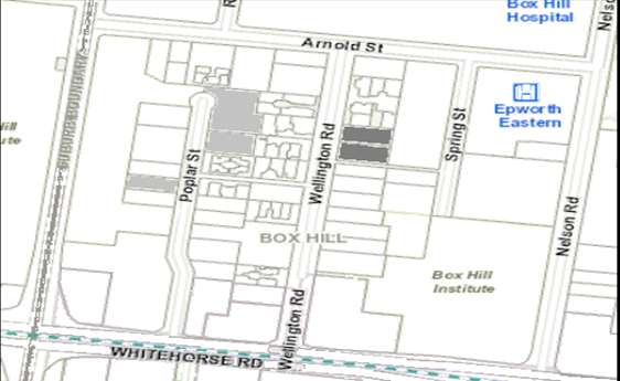
|
|
|
Subject site
|
|
6 Objector Properties
(3 outside of map)
|
North
|
BACKGROUND
History
There are no previous planning applications
from the subject site which are relevant to the proposed development.
Discussion plans
A set of ‘discussion
plans’ (Peddle Thorp Architects, February, 2020
(Revision 4) were provided by the applicant following the
consultation forum in December 2019. These plans were not formally submitted as
part of the application but will be referred to in this report to assist with
forming conditions for changes to the building.
The changes shown in these plans
can be summarised as follows:
a) Communal
laundry facilities within Basement level 1;
b) Delivery
parking area adjacent to laneway;
c) Communal
facilities at rooftop level amended to include a meeting room;
d) Air-conditioning
services location clarified, including associated increase to balcony sizes for
levels ground to 9 and provision of HVAC systems for levels 10-17
e) Electronic
vehicle charging stations (six spaces total) in basement levels 2 and 4;
f) Revised
colours and materials.
The Site and Surrounds
Subject site
The subject site consists of two
allotments relating to the land and No’s 26 and 28 Wellington Road, Box
Hill. These two lots are located on the eastern side of Wellington Road,
approximately 190m north of Whitehorse Road. Of note, Wellington Road is
blocked to vehicle access at its southern end, creating a ‘court
bowl’ end to the street.
The combined area of the two lots
has a frontage to Wellington Road of approximately 38m, with a depth of 38.8m
and covering an area of approximately 1,470sqm.
Each of the two lots contain a single-storey,
detached dwelling orientated west towards Wellington Road and set behind
landscaped front setbacks.
The property at No.26 Wellington
Road contains three canopy trees within the front setback, one of which is
dead. The areas to the rear of No.26 Wellington Road contain canopy trees and
lower level plantings behind the existing dwelling in areas which are currently
utilised as private open space.
The southern boundary of No.26
Wellington Road abuts a laneway which runs east-to-west between Spring Street
and Wellington Road. Bollards have been utilised to close this laneway to
vehicular traffic.
Box Hill Activity Centre
The Box Hill Metropolitan Activity
Centre (MAC) provides retail, education, office, civic, medical, community
facilities, entertainment, dining and recreational opportunities for the
regional population, as well as a hub for local community
activities.
The site is included within the Box
Hill Activity Centre Structure Plan Built Form – Precinct F ‘Major
Development Precinct’ which currently accommodates a mix of developments
including single storey dwellings and more recent multi-level commercial and
mixed use developments. This precinct to the west of Nelson Road is
geared towards medical uses established around the Box Hill Hospital and
education uses associated with the TAFE campus sites between Nelson Road and
Elgar Roads.
Adjoining lots
North – No’s 4, 5, 6
& 7 of 30 Wellington Road
These adjoining lots to the north
each contain a single-storey dwelling. Units 4, 5 each contain areas of
secluded private open space (SPOS) adjoining the northern boundary of the
subject site while No. 7 has its SPOS located approximately 3m further north,
with an on-boundary garage located on its southern boundary.
Unit 6 is located to the north of
Unit 7 and does not have a direct interface with the subject site.
East – No.8 Spring Street
This property contains a
multi-storey car park which is orientated east towards Spring Street. Areas to
the rear (west) of the building contain some landscaping areas adjoining the
eastern boundary shared with the subject site.
South-east – No.14 Spring
Street
The land at No.14 Spring Street
contains a multi-storey apartment building which is orientated east towards
Spring Street but with the north and west elevations also containing balconies
associated with the dwellings.
South – No.22 Wellington
Road
Immediately to the south of the
subject site is a pedestrian laneway which runs east-to-west between Spring
Street and Wellington Road, beyond this laneway is the property at No.22
Wellington Road which is currently vacant.
This lot, along with No’s 18,
16 & 14 Wellington Road have all been cleared of the single dwellings which
previously occupied these lots and are now vacant.
These lots form a parcel which is
currently being considered under Planning Permit Application WH/2018/856 for
development of the land for use and development of the land for a 16-18 storey
building, including residential hotel, medical centre, food and drink premises
and dwellings, reduction in car parking requirements and removal of trees.
This application is under
assessment at the time of writing this report.
- No’s
12 – 16 Wellington Road
Planning permit WH/2016/202 was
issued on the 28th of November, 2016 for the construction of a
fourteen storey building, containing 133 dwellings. This permit expired on the
28th of November, 2019 but an application to extend the permit may
still be considered at the time of writing this report.
West – opposite side of
Wellington Road
On the opposite side of Wellington
Road from the subject site are No’s 25 and 27 Wellington Road which
contain single-storey unit developments which are orientated east towards the
street.
Planning Controls
Residential Growth Zone –
Schedule 3
Pursuant to clause 32.07-5 of the
Whitehorse Planning Scheme (the Scheme) a permit is required to construct two
or more dwellings on a lot.
An apartment development of five or
more storeys, excluding a basement must meet the requirements of clause 58.
Pursuant to the Table of Uses at
clause 32.07-2 of the Scheme, a Food and Drinks Premises is a Section 2, permit
required use. Buildings and works associated with a Section 2 Use trigger the
need for a planning permit pursuant to clause 32.07-8.
Vegetation Protection Overlay
The Vegetation Protection Overlay
has been applied to the land at No.26 Wellington Road only and does not apply
to the land at No.28.
Pursuant to clause 42.02-2 of the
Scheme, a permit is required to remove, destroy or lop any vegetation specified
in a schedule to this overlay.
Pursuant to the Incorporated
Document No.11 – City of Whitehorse – Statement of Tree
Significance (2006), only one tree is included on the Significant Tree
Register, being the Red Iron Bark located within the front setback of No.26
Wellington Road.
This tree is dead and therefore is
exempt for removal under Section 3.0 to the Vegetation Protection Overlay.
Significant Landscape Overlay
– Schedule 9
Pursuant to clause 42.03-2 of the
Scheme, a permit is required to construct a building or construct or carry out
works. This does not apply if a schedule to this overlay specifically states
that a permit is not required.
Section 3 under Schedule 9 to the SLO
states:
A permit is not required to
construct a building or carry out works provided the building or works are set
back at least 4 metres from the base of any tree protected under the provisions
of this schedule.
A permit is required to remove,
destroy or lop a tree.
This does not apply to:
• A
tree less than 5m in height and having a single trunk circumference of 1.0
metre or less at a height of one metre above ground level; or
• The
pruning of a tree for regeneration or ornamental shaping; or
• A
tree which is dead or dying or has become dangerous to the satisfaction of the
responsible authority; or
• A
tree outside the Minimum Street Setback in the Residential Growth Zone.
The proposed development is not
subject to any ‘minimum street setback’ and therefore no permit is
triggered for the removal of trees from the subject site.
Parking Overlay and Clause 52.06
– Car Parking
The Planning Scheme sets out at
Clause 52.06, the car parking rates required for a number of different land
uses. These rates apply except where land is covered by a Parking Overlay. If
the parking rate is not provided then this requires a waiver in the number of
parking spaces to be sought.
The subject site is affected by the Parking Overlay, which
attributes a reduced parking rate to many different uses, including those being
sought under this planning application. The table below outlines the uses
proposed and the number of car parking spaces specified under the Parking
Overlay.
|
Use
|
Rate
|
No. required
|
No. provided
|
|
Dwellings
|
0.5 Resident spaces to each one-bedroom dwelling.
0.75 Resident spaces to each two-bedroom dwelling.
1 Resident space to each three bedroom dwelling (with studies or
studios that are separate rooms counted as a bedroom); plus
0.2 Visitor spaces to each dwelling for the first five dwellings.
0.1 Visitor spaces for each dwelling for any subsequent dwelling
|
94
|
103 total
|
|
Food and drinks premises
|
Per 100sqm of leasable floor area.
|
3
|
3 total
|
|
Total
|
-
|
97 spaces required.
|
106 spaces provided.
|
As indicated in the table above, the
proposed development provides a surplus of nine (9) car parking spaces above
the requirements of the Whitehorse Planning Scheme.
Clause 52.34 – Bicycle
Parking
The application would provide a
total of forty (40) bicycle parking spaces and the end of trip facilities
required. The provision of bicycle facilities exceeds the requirement for
thirty-three (33) spaces under the Whitehorse Planning Scheme.
PROPOSAL
The application proposes a 17
storey mixed-use tower containing dwellings and a food and drinks premises
(café). The facets of the development can be summarised as follows:
Dwellings
A total of 108 dwellings including:
a) 5
x one-bedroom dwellings;
b) 85
x two-bedroom dwellings;
c) 14
x three-bedroom dwellings; and
d) 4
x four-bedroom dwellings.
A total of 106 car parking spaces
would be provided within 4 levels of basement car parking. Of these 106 spaces,
thirty-six (36) would be provided in a tandem arrangement.
40 residential storage cages would
be located within the basement levels.
A total of 40 bicycle parking
spaces would be provided across basements 1-2 and ground floor.
Approximately 420sqm of
communal/recreational space would be provided for residents at roof top level.
These areas would include a gymnasium and outdoor terrace space.
Food and drinks premises
A total of 102sqm of floor area is
proposed in association with a Food and Drinks Premises at ground floor.
Development
The proposed development would
provide 17 levels with the lower four (4) levels forming a ‘podium’
arrangement presenting to Wellington Road.
The ‘tower’ levels
above the podium are recessed to provide delineation from the upper portion of
the tower which is proposed to reach a maximum overall height of 56.6m.
The residential lobby which is
located centrally within the subject site would be accessed via Wellington
Road. With the south-western corner of the building occupied by a 100sqm
Food and Drinks Premises.
All vehicle access for parking
areas, waste collection and maintenance purposes is located via its own
entrance to Wellington Road at the north-west corner of the lot.
While the podium levels utilise a
variety of materials including glazing, perforated mesh and timber finishes,
the tower element of the building would consist mostly of dark tint glazing
which presents as a ‘dark blue’ colour.
CONSULTATION
Public Notice
The application was advertised by
mail to the adjacent and nearby property owners and occupiers and by erecting
notices to the Wellington Road frontage. Following the advertising period
7 objections were received.
The issues raised are summarised as
follows:
· Overdevelopment;
· Traffic
impacts;
· Overshadowing;
· Overlooking/loss
of privacy;
· Wind
impacts;
· No
need for proposed café;
· Impact
on existing services;
· Impacts
associated with construction phase;
· Noise
impacts;
· Glare
from building materials;
Consultation Forum
A Consultation Forum was held on 18th
December, 2019. The meeting was chaired by Councillor Barker and attended
by the applicant, planning officer and one objector.
While no resolutions were reached
at the meeting a number of issues were discussed which resulted in the
applicant providing discussion plans as detailed earlier in this report. These
discussion plans are those referred to in this report for the purpose of
forming conditions.
Referrals
External
Public Transport Victoria
The application was referred to
Public Transport Victoria who did not object to the proposal and did not seek
to include any conditions.
Internal
Urban design
Council engaged MGS Architects to
provide urban design advice on the proposed development on the originally
lodged material which consisted of a taller, 21 level building, to which
substantial concerns were raised regarding the height, massing and its response
to the surrounding area.
The concerns raised by MGS largely
related to the scale of the building and the impact this had on interfaces with
the street and the ability of the development to integrate with the emerging
character of the area.
Through the application process,
the height of the building has been reduced to 17 levels (reduced height from
69.4m to 56m) and with the podium height revised down to level 4 (from level
10).
Further formal comments were not
sought on the advertised material as the changes made by the applicant in
response to the original MGS comments substantially addressed the concerns as
will be discussed in the assessment section of this report.
Engineering and Environmental
Services Department
· Transport
Engineer
Council’s Traffic Engineering
Unit were generally supportive of the proposed development with regards to car
parking numbers and traffic generation but cited the need for conditions
relating to car parking allocation and some minor configuration details within
the basement levels.
· Assets
Engineer
The Assets Engineering Unit are
generally supportive of the proposed development subject to the inclusion of
standard conditions.
Planning Arborist
Council’s arborist has
expressed that trees within the lot’s frontage to Wellington Road should
be retained but otherwise suggested that vegetation to the rear of the site can
be removed due to its low retention value.
No concerns were raised with
regards to the protection of neighbouring vegetation.
Parkswide
Council’s Parkswide
Department have reviewed the proposed development and have no objections
subject to the implementation of tree protection measures/conditions for trees
within the adjacent road reserve.
ESD Advisor
Council’s ESD advisor has
reviewed the proposal and concluded that the proposed development falls short
of compliance with council’s ESD policy under clause 22.10 of the Scheme.
Conditions have been provided which would address this issue.
DISCUSSION
Consistency with State and Local
Planning Policies
The subject site
is zoned Residential Growth which contains planning objectives geared towards
increased built form and use density/activity in areas well serviced by public
transport and other services. The proposal complies with this general direction
under the purpose of the zone by providing a range of residential and
commercial uses for the site in a more intensive form to facilitate greater
residential density and employment opportunities in the area.
Acknowledging that
the zone suggests a preferred maximum height of 13.5m, this is a discretionary
measure and must be balanced in line with the site’s location within a
Metropolitan Activity Centre, and that which has an emerging character based on
buildings, both constructed and approved, that substantially exceed this
discretionary height.
The site is well
connected to the public transport systems and road network supporting efficient
uptake of both tram, train, walking and cycling routes to and from the subject
site. State policy encourages the intensification of employment generating uses
in areas with these locational characteristics close to where people live
(clauses 11.03-1S - Activity Centres and 15.01-4R - Healthy
Neighborhoods – Metropolitan Melbourne).
By reference to
State planning policy in general, the subject site represents a significant
redevelopment opportunity to deliver higher density residential uses and
complementary commercial activity given its location within the Box Hill
Metropolitan Activity Centre, its accessibility to Whitehorse Road to the south
and its proximity to a broad range of urban infrastructure including public
transport services, employment opportunities and commercial facilities.
Similarly, local
planning policy identifies the vibrant and mixed use nature of activity centres
as an important attribute of the municipality and seeks to encourage their long
term viability through development and land uses that contribute to their
adaptation, redevelopment and economic growth. Clause 21.07 - Economic
Development, also seeks to increase the number and diversity of employment
opportunities, specifically identifying retail and office activities as an area
where opportunities have been created, particularly in redevelopment sites.
While this may be the case, the subject site is limited in the ability to
provide a variety of land uses given the residential zoning in which many
commercial uses are either capped in terms of the square meterage that can be
proposed or are outright prohibited.
The proposed
density of the development is consistent with both State and Local Policies
such as clauses 16.01-1S - Integrated Housing, 17.01-1R - Diversified
Economy – Metropolitan Melbourne, 18.01-1S - Land Use and
Transport Planning which encourages concentration of development and
employment opportunities in and around activity centres and intensifying
development on sites well connected to public transport. This enables more
efficient use of existing infrastructure.
The policy under
clause 22.07 – Box Hill Metropolitan Activity Centre promotes
design excellence in new developments through encouraging built form which
provides for increased height which is sensitive to adjoining residential areas
and which provides activated and functional interfaces with the public realm to
enhance walkability.
Overall, the
proposed re-development of the site for increased residential density is
considered to have a strong level strategic planning support subject to
appropriate contextual design and absence of unreasonable amenity impacts to
the surrounding area.
Land uses
As discussed earlier, the site is
located within a Metropolitan Activity Centre (MAC) which is of importance not
only to the municipality, but also to the broader metropolitan region given its
capacity for change and connections to other Activity Centres, residential
areas and multiple public transport options.
The proposed food and drinks
premises would be a modest addition of commercial activity in the context of
the MAC and would be generally acceptable subject to standard conditions which
require the operation to avoid unreasonable amenity impacts through noise,
odours and storage of goods/waste. These conditions would provide for an
outcome which is generally consistent with the policy under clause 22.05
– Non-residential uses in residential areas of the Whitehorse
Planning Scheme.
Design and Built Form
In assessing the appropriateness of
the proposed built form, planning officers refer to the decision guidelines of
the Commercial 1 Zone, the objectives and strategies outlined under Clause
15.01-1S - Urban Design and Clause 15.01-2S - Building Design and
where relevant the policy documents relating to Urban Design Guidelines for
Victoria (Department of Environment, Land, Water and Planning, 2017) and
Apartment Design Guidelines for Victoria (Department of Environment, Land,
Water and Planning, 2017).
It should again be acknowledged
there is a strong level of policy support for an intensive development of the
subject site, subject to an appropriate design response to sensitive interfaces
and an appropriate level of architectural merit to warrant the proposed
building’s scale.
The following sections of this
report will assess the key areas of the proposal’s design against the
relevant criteria under the Whitehorse Planning Scheme.
Entries and street interfaces
Wellington Road
The proposed lobby would be
orientated west towards the street and would be clearly identifiable in views
along Wellington Road. The double-height overhang to the lobby, which is
recessed approximately 8m from the street frontage provides both a transitional
space and weather shelter which is appropriately scaled for the number of
residences who would gain access to the building from the street. While the
lobby areas are recessed into the site, these are sufficiently legible even in
views from the north along Wellington Road providing appropriate identification
to the building entrance from close up and further distanced from the site.
The lobby itself provides adequate
circulation space in addition to the outdoor area with provision for mail
delivery and lift access. The 2.3m corridor width adjacent to the lift entries
is suitable for pedestrian movements and functional matters such as furniture
manoeuvring for arriving residents.
While the corridors of each level
would not provide access to natural daylight and ventilation opportunities,
this is in itself not fatal to the application where the lobby and circulations
spaces are otherwise generally sufficient to meet the objectives under Standard
D18 – Building entry and circulation objectives.
The treatment to the north-facing,
on-boundary walls at ground floor to level 3 would be subject to a condition
for its detail to be provided prior to the endorsement of plans with its
treatment currently nominated as ‘custom art boundary wall’.
Subject to further detail being provided to the satisfaction of council, there
is no objection to the use of this wall for artwork, murals or other high quality
design which would provide visual interest and acceptable architectural
treatment adding to the presentation of the development to Wellington Road.
The planter areas at ground across
the frontage, including the bicycle storage area would soften the presentation
of the building at pedestrian level and would integrate with the more generous
planter areas within the south-western corner to achieve an acceptable
landscaping outcome for the site. Service cupboards have been shown along the
Wellington Road frontage, integrated into the building’s facade which
indicates an appropriate level of consideration has been afforded to site
services to satisfy objectives under Standard D22 – Site services.
In the context of the MAC setting
of the subject site, the requirement for ‘deep soil’ planting under
Standard D10 areas is considered onerous in this case and would reduce the
efficient development of the subject site. The landscaping detail shown in the
plans prepared is generally acceptable to meet the objectives under Standard
D10 – landscaping which requires development to respect the
(landscape) character of the area.
The landscaping visible from the
public realm that is proposed for the development would include planter areas
at both ground floor and atop level 4 above the buildings podium. Planting
areas on the western boundary to Wellington Road would sit forwards of the
service cupboard and bicycle parking areas, while more generous plantings would
be located in the south-western corner in the open areas associated with access
to the residential lobby and Food and Drinks premises.
With the Box Hill Transit City
Activity Centre Plan (2007) recommending buildings in Precinct ‘F’
be constructed to street frontage, the landscaping areas strike an appropriate
balance between the efficient development of the subject site and the need to
provide an urban design outcome which ameliorates the overall scale of the building
to provide an acceptable streetscape outcome.
The plantings to the sides and rear
of the proposed building would include mid-height canopy species including
Jacaranda, Capital Pear, Luscious Water Gum and Native Frangipani which would
provide visual relief to the adjoining dwellings to the north and a combined
landscaping strip with the commercial car park to the west which contains other
canopy trees adjoining the boundary with the subject site.
The landscaping areas at upper
levels would be provided along the perimeter of terrace areas and provide some
softening of the building when viewed from a distance but are not integral to
the overall design of the building.
Overall, the proposed landscaping
response is an acceptable response to the objectives under Standard D10 –
Landscaping.
Overshadowing to Wellington Road
While the proposed building form is
considered to provide an acceptable podium height and interface at ground
level, the overall scale and massing of the building would cast significant
shadow to Wellington Road including to its opposite (western) side which is
undesirable given the street is nominated as a Pedestrian Priority Corridor
under the Structure Plan (2007).
The extent of shadowing cast by the
proposed development to the western side of Wellington Road is a matter which
council’s urban design consultant was particularly critical of, notably,
the level of shadowing cast after 10:00am on the September Equinox as it
conflicts with a raft of planning policies and established urban design
principles.
The applicant has provided images
which detail the level of shadowing to the western side of Wellington Road
reducing to a point where by 10:20am on the September Equinox, a pedestrian may
receive some direct sunlight when standing on the footpath on the western side
of the street (See Drawing TP-108).
Achieving no additional shadowing
by 10:00am would be readily achieved through modest alterations to either the
buildings height or setback and would be addressed through a condition.
Southern laneway
The interface with the adjoining
laneway would be substantially improved from the existing condition where
paling fences close the laneway from passive surveillance.
The erosion of the south-western
corner of the proposed building would afford a direct line of sight through the
development into the opening of the laneway which would increase both its
legibility and safety. While the three (3) dwellings located within the
south-eastern corner of the development would contain 1.8m high fencing to the
southern boundary, this outcome is considered to be acceptable in light of the
increased surveillance added to the laneway from the dwellings atop and the
need to provide security for the ground floor residences.
The above outcomes are generally in
line with Objective 5.1.5 of the Urban Design Guidelines for Victoria
(Department of Environment, Land, Water and Planning, 2017) which aims to
maximise safety through informal surveillance of streets and public spaces from
within buildings in activity centres.
The introduction of a
‘lighting plan’ through condition will further address the use of
the laneway and its safety and legibility. This condition was discussed with
the applicant at the consultation forum in December, 2019 who advised that the
provision of lighting to the southern interface was not objectionable.
Additional lighting to the laneway would be generally in line with the
objectives under Standard D9 – Safety of clause 58 of the Scheme
which requires developments to ensure the layout provides for the safety and
security of residents.
The lighting plan will ensure
lighting at appropriate levels to illuminate the laneway while protecting the
amenity of residences on either side of the lane from excessive light spill.
Overall, the proposed development
would provide acceptable outcomes to both the Wellington Road and laneway
interfaces, through appropriately scaled and legible entrance points and
improvements to the safety and presentation of the lane. The development would
be integrated with these two interfaces, consistent with the objectives under
Standard D5 – Integration with the street, under clause 58 of the
Scheme.
Podium design
At four levels (approximately 14m
in height) the podium scales appropriately to Wellington Road which has a width
of approximately 19m between boundaries. The wall to width ratio allows the
development to sit within a 1:1 ratio of wall height to street width as a
readily accepted urban design outcome for creating pedestrian appropriate streetscapes.
The use of two distinctive framing
elements to the Wellington Road façade would reference the two
allotments consolidated to form the subject site and would assist with
retaining a sense of grain and rhythm to the street.
While the podium levels (ground to
level 4) would hold the street edge, the remaining sections of the podium are
set back from boundaries to avoid sensitive interfaces with adjoining lots to
the north and create better integration with the laneway to the south as
discussed earlier in this report.
Overall, the podium form of the
building is generally appropriate in both is design and function to create an
outcome which addresses the amenity of the streetscape and through provision of
a level of architectural quality sought under clause 22.07 – Box Hill
Metropolitan Activity Centre.
Upper levels and design quality
As mentioned above, the policy at
clause 22.07-3 of the Scheme details that the Responsible Authority will
encourage development (that amongst other things) promotes design excellence
and contributes to Box Hill’s sense of place. Earlier sections of this
report have detailed the location of the subject site in the Box Hill MAC and
the policy setting which encourages significant development in terms of density
and building height.
In this regard, the significant
level of change proposed through the development is consistent with this policy
vision and also in line with the objectives under Standard D1 – Urban
context which requires development to be appropriate to the urban context.
While the proposed building would
be highly prominent in the short to medium term, the upper levels of the
proposed building have been designed to be viewed in the round and include
appropriate levels of articulation and setbacks at varying levels to give
visual interest to the structure.
Façade
treatments/materials
The upper levels while proposing
substantial use of glazing, are legible as residential uses through the
considered level of articulation provided in balcony areas and other openings
across the façade that are well documented in the render images provided
with the application material.
Ensuring the same level of
architectural detail is carried across from the renders to the approved
development, a ‘façade strategy’ would be required through
conditions. This Strategy would include reports, detailed images of specific
architectural outcomes such as window openings and soft details which are not
typically attached to elevation drawings.
The façade strategy would
also require the application to address any significant amenity impacts arising
from glare/reflectivity of the chosen materials through an engineering report.
The discussion plans (February
2020) provided by the applicant removed some of the more reflective and bright
façade materials in an attempt to ensure the building is appropriately
subdued in its presentation to the area. While the removal of some gold
coloured treatments is an appropriate choice, the final detail will need to be
fully resolved in line with the requirements of the façade strategy
condition discussed above.
While planning officers are
generally supportive of the overall design of the tower element above the
podium in terms of its form and choice of materials and inclusion of conditions
to reduce shadowing to Wellington Road as discussed earlier in this report
Amenity
Visual bulk and overlooking
Standard D14 – Building
setbacks under clause 58 of the Scheme requires development to be set back
from boundaries as to respond to the context of the surrounding area, provide
adequate amenity and daylight into dwellings and avoid unreasonable overlooking
to neighbouring lots.
While properties to the east
contain commercial car parking structures and are not particularly sensitive,
consideration must be provided for any further/future development of this site
and whether the proposed development has appropriately responded to the
development potential of this adjoining lot.
The properties to the north and
south contain dwellings and residential land which must be appropriately
responded to as either existing or future interfaces which contain open space
areas and other habitable areas.
North
At ground floor, the proposed
north-facing walls would be set back between 5.4m to 6.3m to accommodate
private open space and landscaping areas associated with the adjoining
dwellings. The exception to this is the on-boundary length of wall associated
with the bike storage area which continues up to level 4.
The on-boundary section of wall
would be set forwards of the neighbouring dwelling, adjacent to car
parking/access areas and would therefore not provide any unreasonable visual
bulk impacts. The east-facing, habitable room windows associated with bedrooms
behind this north-facing wall would require screening or other treatments to
avoid unreasonable overlooking into the adjoining dwellings further east. This
issue can be addressed through conditions.
The remaining north-facing walls,
being set back from the boundary would provide an appropriate level of
separation from the more sensitive interfaces with dwellings to the north,
which in the context of their location in the Box Hill Metropolitan Activity
Centre, is not unreasonable.
With regards to overlooking and
privacy issues, a condition will require the northern boundary to be treated
with 1.8m high, visually solid fencing to address overlooking generally in line
with the overlooking standard at clause 55 of the Scheme. While ‘ResCode’
is not strictly applicable for the proposed development which is to be assessed
against the Clause 58 – Apartment development provisions, this is
seen as a suitable guide in the absence of any prescriptive overlooking
standards under clause 58.
At the levels above, the
north-facing balconies and habitable room windows would be required through
condition to provide overlooking treatments in line with the recommendations
under clause 55 of the Whitehorse Planning Scheme where protruding within 4.5m of
the northern boundary.
Where habitable room windows or
balconies are set back beyond this 4.5m distance, this is an equitable response
to overlooking and privacy issues in the context of the MAC. This approach is
reflected in the objectives of Standard D14 – Building separation of
the Scheme which contains the objective to limit views into habitable room
windows and private open space of new and existing dwellings.
South
As detailed earlier in this report,
the properties to the south, on the opposite side of the adjoining laneway are
currently vacant, with all buildings demolished from the lots. These lots have
approval for a fourteen (14) storey apartment building and another live
application proposing a multi-storey mixed use building.
While overshowing and visual bulk
would result in some impact on either of these developments, these would not be
unacceptable in the MAC context.
With regards to overlooking, a
condition will require any habitable room window or balcony perimeter not set
back 4.5m to the centre-line of the adjoining laneway to be treated with
overlooking treatments in the same manner as the northern elevation discussed
earlier.
East
Similar to assessment of the north
and southern interfaces, the development has provided a series of setbacks from
the eastern boundary which generally allow the development to be set back more
than 4.5m from the boundary but not in all instances. These areas would be
addressed through a condition.
While the eastern interface abuts a
commercial car park, this approach is necessary to ensure the proposed
development would not unreasonably impact on any future development of this
adjoining site for residential use.
Internal amenity
Internal layouts and access to
dwellings
The proposed layouts of the various
dwellings types are generally compliant with the Standards relating to access
and internal design/circulation standards.
The living areas have been
demonstrated to meet standards relating to function layout for both living area
and bedroom dimensions. Notably, the majority of dwellings in the development
are provided with multiple aspects which provide for acceptable access to
daylight, meeting standards D26 & 26 for daylight and window design
respectively.
Balcony areas
As detailed earlier in this report,
the applicant has supplied discussion plans (Feb 2020) which detail provision
of centralised HVAC systems for dwellings on levels 10 and above and the levels
below containing air-conditioning systems on individual balconies. This detail
was provided by the applicant following concerns being raised by planning
officers regarding the dimensions of balcony areas and their ability to contain
air-conditioning units.
The discussion plans detail some
increased balcony sizes to accommodate the air-conditioning units while
complying with the balcony dimensions under Standard D19 – Private
open space which suggests: ‘If a cooling or heating unit is
located on a balcony, the balcony should provide an additional area of 1.5
square metres’.
In principle the increased balcony
sizes is supportable but there are a number of dwelling floor templates where
this would result in a loss of internal living areas which would translate into
a substantial variation under Standard D24 – Functional layout by
reducing the 12sqm living room areas to gain increased balcony space. While the
reduction to living areas to achieve the increased balcony space varies from
dwelling to dwelling, these reduction generally relate to a 1 to 1.5sqm area.
This issue relates to the floor
templates for Dwelling: 1B, 1C, 1D, 8A, 8B, 12 & 15A which equates to 13
dwellings at levels 1-9.
With the subject site being
relatively unconstrained, these variations are not an acceptable design
response to the amenity of future residents and would result in an unacceptable
number of dwellings providing poor amenity outcomes.
While resolving this issue may
impact on the yield of the development, there is scope to undertake these
changes internally without significant alteration to the building envelope and
would be addressed through conditions which require dwellings to have compliant
balcony and living area dimensions.
Storage
Of the proposed 108 dwellings, 92
would meet the suggested storage areas under Standard D20 – Storage and
16 of these would trigger a variation.
Of the 16 dwellings which trigger a
variation, this is due to the ‘internal’ storage areas within the
dwelling itself falling short of the volume but the ‘total’ volume
would be met through additional storage space being provided within the basement
areas. The variations sought vary between dwelling to dwelling but are
typically less than 1 cubic metre.
With only a limited number of the
dwellings proposing a modest variation to this Standard, this is considered to
be acceptable in this particular case.
Car Parking and Traffic
As outlined earlier in this report,
the application does not trigger a reduction to car parking requirements under
the Whitehorse Planning Scheme and is therefore considered to be acceptable in
this regard.
The Cardno Traffic Report (June
2019) submitted with the application provided SIDRA analysis of the anticipated
future traffic volumes of Arnold Street and Wellington Road to determine the
future performance of the intersection, concluding that the intersection would
continue to operate satisfactorily for the anticipated future traffic volumes
and that the proposed development ‘would have a negligible impact on the
operation of the intersection’.
The Cardno report has been reviewed
by council’s Transport Unit who generally agree with the findings and are
satisfied that the proposed development would not result in unreasonable traffic
impacts to the surrounding street network.
With regards to the proposed car
parking access and arrangement, Council’s Transport Unit have suggested
some improvements which can readily be addressed through conditions.
With regards to car parking
allocation, it is significant that the Parking Overlay requires less than whole
numbers of car parking for single-bedroom dwellings and therefore it becomes an
academic task to allocate spaces to individual, single-bedroom dwellings. As
such, while tandem spaces will be allocated to a single dwelling or tenancy
through condition, the spaces will not be specifically allocated beyond
requiring the application to demonstrate that there would be no reduction in
spaces triggered under the requirements of the Parking Overlay.
Overall, subject to conditions the
parking and associated traffic conditions are acceptable when measured against
the decision guidelines of clause 52.06 – Car Parking and the Parking
Overlay.
Objectors Concerns not
Previously Addressed
Overdevelopment;
The proposed built
form has been assessed as an acceptable outcome earlier in this report with
regards to the context of the subject site being within a Metropolitan Activity
Centre, with conditions recommended to reduce shadowing impacts to the street,
avoid unreasonable overlooking and other impacts.
Overall, the
proposed development is not considered to be an overdevelopment for these
reasons.
Traffic
impacts;
As discussed
earlier in this report, the application has provided detailed traffic analysis
of the proposed development which has been reviewed and supported by
council’s Transport Unit.
The proposed
development would not result in material impacts to the surrounding street
network.
Overshadowing
Subject to the
conditions for the reduction of overshadowing to Wellington Road, the amount of
shadowing cast to neighboring lots is not unreasonable as assessed earlier in
this report.
Overlooking/loss
of privacy
Conditions have
been suggested to ensure no unreasonable loss of privacy as assessed earlier in
this report.
Wind impacts
A Wind Impact
Assessment report, including model testing has been required for submission and
approval by the Responsible Authority prior to the endorsement of plans as
discussed earlier in this report.
No need for
proposed café
The role of a
planning permit application is not to assess the ‘need’ for a food
and drinks premises of this scale but whether it would result in unreasonable
amenity impacts and otherwise complies with the objectives under the Residential
Growth Zone.
Subject to
standard conditions, the proposed café would provide for a modestly
scaled premises which would service the needs of the local community without
any unreasonable impact through noise, traffic or other amenity impacts. This is
generally in line with the local policy at clause 22.05 – Non-residential
uses in residential areas as assessed earlier in this report.
Impact on
existing services
The subject site
is located in an area which is provided with all reticulated services and there
is no material provided to council that the proposed development would result
in an unreasonable strain on these services.
Impacts
associated with construction phase
A Construction
Management Plan (CMP) would be required through a condition of permit.
Noise impacts
The CMP would
address noise impacts during the construction phase in line with the relevant
requirements. This document must be provided to and approved by the responsible
authority prior to commencement of any works.
Noise associated
from the dwellings would not result in unreasonable impacts, being residential
in nature.
Glare from
building materials
A ‘façade
strategy’ including an engineering report would be required for approval,
prior to the endorsement of plans to ensure the selected materials would avoid
glare impacts (amongst other issues) as discussed earlier in this report.
CONCLUSION
The proposal for construction of
Development of the land for a 17-storey storey building containing dwellings
and ground floor Food and Drinks Premises (Cafe) and associated is an
acceptable response that satisfies the relevant provisions contained within the
Whitehorse Planning Scheme, including the State and Local Planning Policies,
the Residential Growth Zone and Clause 58, Apartment development.
Subject to the conditions discussed
throughout this report, the proposed building is considered to provide a level
of intensification envisaged under the guidance of the Residential Growth Zone
and Structure Plan (2007) and achieves an acceptable level of architectural
quality to justify the built form.
A total of 7 objections were
received as a result of public notice and all of the issues raised have been
discussed as required.
It is considered that the
application should be approved.
Attachment
1 Plans and
perspective images 
2 Discussion
plans 
Council Minutes 25
May 2020
9.1.3 37-39
Harrow Street, BOX HILL (LOT 85 LP 2004 28B and LOTS 1-2 TP 678857 28B) Use and
Buildings and Works to Construct a Residential Hotel (including associated food
and drink premise, retail/office and vegetation removal) and reduction of the
car and bicycle requirements
SUMMARY
This application was advertised,
and a total of 29 objections were received. The objections raised issues with
regard to building mass and scale, neighbourhood character, height, boundary
setbacks, parking/access/traffic and safety, land use composition, overlooking,
overshadowing, property devaluation and air pollution. A Consultation Forum was
held on Wednesday 19 February 2020 and was chaired by Councillor Barker, at
which the issues were explored, however no resolution was reached between the
parties.
Following the Consultation Forum, revised plans, a
written assessment and traffic statement were submitted, tabled as
‘without prejudice plans and documentation’, seeking to address
outstanding concerns of Council and issues raised by objecting parties. These
amended plans have not been formally re-advertised as the changes do not result
in additional material detriment to adjoining owners and occupiers but were
circulated to objectors for additional comment. No additional issues were
raised by objectors.
The without prejudice plans introduce a number of
improvements to the proposal, namely: a 900mm maximum building height
reduction, increased level 1 articulation to the eastern side elevation and
increased setbacks from the southern street frontage at level 4.
This report assesses the application against the relevant
provisions of the Whitehorse Planning Scheme, as well as objector concerns. It
is recommended that the application be supported, subject to conditions.
|
RECOMMENDATION
That Council:
A. Being the Responsible Authority, having
caused Application WH/2019/938 for 37-39 Harrow Street, BOX HILL (LOT 85 LP
2004 28B and LOTS 1-2 TP 678857 28B) to be advertised and having received and
noted the objections is of the opinion that the granting of a Planning Permit
for the Use and Buildings and Works to Construct a Residential Hotel
(including associated food and drink premise, retail/office and vegetation
removal), and reduction of the car and bicycle requirements is acceptable and
should not unreasonably impact the amenity of adjacent properties.
B. Issue a Notice of Decision to Grant a Permit
under the Whitehorse Planning Scheme to the land described as 37-39 Harrow
Street, BOX HILL (LOT 85 LP 2004 28B and LOTS 1-2 TP 678857 28B) for the Use
and Buildings and Works to Construct a Residential Hotel (including
associated food and drink premise and vegetation removal), and reduction of
the car and bicycle requirements, subject to the following conditions:
1. Before the development starts, but
excluding the works detailed in the Early Works Plan, amended plans must be
submitted to and approved by the Responsible Authority in a digital format.
Once approved, the plans will be endorsed and will then form part of the
permit. The plans must be drawn to scale, with dimensions, and be generally
in accordance with the plans prepared by Ascui & Co Architects, revision
C, dated 24/3/2020, but modified to show:
a) The ground
floor ‘retail/office’ deleted and converted back into residential
hotel related purposes in accordance with the Residential Growth Zone. This
requirement also includes any consequential changes to the car park
arrangements on the plans, the Car Parking Management Plan (CPMP) and Green
Travel Plan (GTP) as referred in Condition 1;
b) The fifth floor level deleted, with the sixth
floor level becoming the new fifth floor level in its current format and
layout;
c) The rear loading bay to have the following
amendments:
i. To also be used as a drop off-pick up
facility for patrons and visitors;
ii. To have direct pedestrian access into the
rear of the building, to the common internal corridor;
d) The eastern external kitchen door of the food
and drink premises deleted, and a suitable internal connection provided to
the common corridor;
e) A passing area at the accessway ramp entrance
at least 6.1 metres wide and 7 metres long in accordance with Clause 52.06;
f) A 2.8 metre ramp clearance height at the
basement entry for commercial vehicles;
g) The ‘stop-go’ signal in the rear
laneway must be relocated on site.
h) 2 additional car spaces (31 car spaces in
total) provided for staff associated with the food and drink premises;
i) 6 visitor bicycle spaces (15 bicycle
spaces in total) provided either in the front setback area or in the ground
floor foyer area;
j) A pedestrian sight triangle for the
accessway at the rear property boundary;
k) Locations identified in the urban design of
the front façade for future business signage;
l) All necessary exhaust fans detailed in
locations that appropriately mitigate against external amenity impacts on
noise generation;
m) Any changes required to reflect Conditions 3
(landscape plan), 4 (streetscape plan), 6 (CPMP), 8 (SMP), 9 (wind report),
10 (WMP) and 12 (GTP) of this permit;
n) A GTP in accordance with Condition 12 of this
permit;
o) An updated CPMP accordance with Condition 6
of this permit.
All of
the above must be to the satisfaction of the Responsible Authority. Once
approved these plans become the endorsed plans of this permit.
2. The development as shown on the endorsed
plans must not be altered (unless the Whitehorse Planning Scheme specifies
that a permit is not required) without the prior written consent of the
Responsible Authority.
Landscaping
3. No building or works must be commenced,
excluding the works detailed in the Early Works Plan, until a landscape plan
prepared by a suitably qualified and experienced person or firm has been
submitted to and endorsed by the Responsible Authority. Once endorsed
this plan shall form part of this permit. This plan must show:
a) Planting throughout the development including
front façade treatment, balconies, terraces and vertical gardens,
comprising vertical shrubs capable of:
i. Providing a complete garden scheme; and
ii. Softening the building bulk;
iii. Nomination of proposed services;
iv. A maintenance schedule including;
v. Specific procedural measures confirming how
all vertical/hanging/cascading plants will be maintained, particularly
planting in the southern laneway being on the south side of the building;
vi. Ongoing maintenance plan;
vii. Detailed on how the ‘integrated planters’
will work;
viii. Soil depths for all planted species;
ix. Irrigation system/program for all common property
landscaping and containerised plantings, including details of frequency and
water delivery method;
x. Any dead or dying plant species detailed in
the landscape plan detailed in Condition 3 of this permit to be replaced with
similar plant species as necessary to the satisfaction of the Responsible
Authority.
Landscaping in accordance
with this approved plan and schedule must be completed before the development
is occupied. Once approved these plans become the endorsed plans of this
permit.
4. Prior to the commencement of works, excluding
site excavation, piling and basement slab, detailed streetscape plans must be
prepared to the satisfaction of the Responsible Authority detailing works and
treatments that are to take place within the road reserves between the front
boundary and back of road kerb, addressing the following:
a) Finished levels that maintain appropriate
interface levels to surrounding land for safe and functional pedestrian
movements;
b) Maintenance/replacement of pedestrian and
cyclist infrastructure and/or linkages;
c) Existing assets in the road reserve;
d) Consideration of landscaping and public realm
treatment requirements of other conditions of this permit;
e) Design and materials must be consistent with the
Box Hill Urban Realm Treatment Guidelines;
f) Existing street trees must not be
removed or damaged except with the written consent of the Responsible
Authority.
5. The garden areas shown on the endorsed plan
must only be used as gardens and must be maintained in a proper, tidy and
healthy condition to the satisfaction of the Responsible Authority.
Should any tree or shrub be removed or destroyed it may be required to be
replaced by a tree or shrub of similar size and variety.
Car Parking Management Plan
6. Before the development commences, but
excluding the works detailed in the Early Works Plan, a Car Park Management
Plan to the satisfaction of the Responsible Authority must be submitted to
and approved by the Responsible Authority. When approved, the Car Park
Management Plan will be endorsed and will form part of this permit. The
Car Park Management Plan must address, but not be limited to, the following:
a) The number, dimensions, and allocation
(including number and location) of car parking spaces for the residential
hotel and visitors;
b) The location of at least 1 car space for
shared use, made available to patrons and staff 24 hours a day;
c) At least 1 electric charging station and
hours provided of available use;
d) The management of any applicable visitor car
parking spaces and security arrangements for occupants of the development,
including details on how residential visitors are to access car parking;
e) Management of rear loading bay both (a)
servicing the food and drink premises kitchen and (b), the drop off / pick up
facility, including all vehicular and pedestrian related activity, and any
potential traffic conflict caused by queuing instances from either or both
mentioned purposes;
f) Details of way-finding, cleaning and
security of the end of trip bicycle facilities;
g) The number and allocation of storage spaces;
h) Policing arrangements and formal agreements;
i) Detail any access controls to the
parking area, such as boom gates which must take into account the required
queue length required as per section 3.4 of AS 2890.1.
j) A schedule of all proposed signage
including:
i. Directional arrows and signage,
informative signs indicating location of disabled bays and bicycle parking;
ii. Exits;
iii. Restrictions;
iv. Pay parking system; and
v. Any other relevant signs;
vi. The collection of waste and garbage including the
separate collection of organic waste and recyclables, which must be in
accordance with the Waste Management Plan required by Condition 10; and
vii. Details regarding the management of loading and
unloading of goods and materials.
7. The provisions, recommendations and
requirements of the endorsed Car Park Management Plan must be implemented and
complied with to the satisfaction of the Responsible Authority.
Sustainability Management Plan (SMP)
8. Prior to the endorsement of plans under
Condition 1 of this permit, an amended SMP to the satisfaction of the
Responsible Authority must be submitted to and approved by the Responsible
Authority. Once approved, the amended SMP will be endorsed and will
form part of this permit. The amended SMP must be generally in accordance
with the SMP prepared by ADP Consulting, dated 19/12/2018, but modified to
include, show or address:
a) Consistency with Condition 1.
b) A STORM Assessment or equivalent addressing
stormwater quality performance, in addition to ensuring that the Responsible
Authority’s collective integrated water management expectations and
requirements pursuant to Clauses 34 and 44 of the State Environment Protection
Policy (Waters), are satisfied.
c) A STORM Assessment or equivalent addressing
stormwater quality performance, in addition to ensuring that the Responsible
Authority’s collective integrated water management expectations and
requirements pursuant to Clauses 34 and 44 of the State Environment
Protection Policy (Waters), are satisfied.
d) A complete, published BESS Report, with an
acceptable overall score that exceeds 50% and exceed the ‘pass’
marks in the categories of Water, Energy Stormwater and Indoor Environment
Quality (IEQ) to the satisfaction of the Responsible Authority.
e) Preliminary NatHERS Energy Efficiency
Assessments for 10% of dwellings a part of the development reflecting that
the residential portion of the development achieves an average minimum 6.5
star rating and whereby no apartment achieves below a 5.5 star rating.
Maximum cooling loads must be ≤ 21 MJ/m2/annum.
f) A Preliminary BCA Section J or JV3
Energy Efficiency Assessment for non-residential areas indicating a 20%
improvement in energy efficiency performance with respect to the
development’s reference/base case. The assessment is required to
include indicative commitments towards thermal performance (i.e. R-values),
artificial lighting and glazing (BCA Glazing Calculator indicating U- and
SHGC- values) for non-residential areas.
g) Daylight modelling assessment for residential
and non-residential areas to the satisfaction of the Responsible Authority.
h) Double glazing for all external windows.
i) Control car park ventilation with CO sensors.
j) Control all common, external, service
and lift area lighting with sensors or timers.
k) Control common, service and lift area
ventilation with sensors or timers.
l) Provide energy efficient heating,
cooling and hot water systems indicating the associated COP and EER values or
energy efficiency star ratings.
m) Include a minimum 10 kW renewable energy
photovoltaic system.
n) Provide water efficient fixtures and
appliances indicating the associated WELS ratings.
o) Provide secure bicycle storage areas for both
residents and visitors.
p) Divert at least 70% of construction and
demolition waste from landfill.
The
provisions, recommendations and requirements of the endorsed Sustainability
Management Plan Assessment must be implemented and complied with to the
satisfaction of the Responsible Authority.
Wind Report
9. Prior to the endorsement of plans under
Condition 1 of this permit, an amended Wind Assessment Report to the
satisfaction of the Responsible Authority must be submitted to and approved
by the Responsible Authority. Once approved, the amended Wind
Assessment Report will be endorsed and will form part of this permit.
The amended Wind Assessment Report must be generally in accordance with the
Wind Assessment Report prepared by VIPAC and dated 8th November
2019, but modified to include (or show):
a) Wind tunnel testing to demonstrate:
i. Walking comfort along the Harrow Street
frontage;
ii. Standing comfort at the southern front and
eastern rear entrances, communal open areas, terraces and balconies.
Waste Management Plan
10. Before the development commences, but excluding
the works detailed in the Early Works Plan, an amended Waste Management Plan
to the satisfaction of the Responsible Authority must be submitted to and
approved by the Responsible Authority. When approved, the amended Waste
Management Plan will be endorsed and will form part of this permit. The
amended Waste Management Plan must be generally in accordance with the Waste
Management Plan prepared by Salt Engineers, dated 26th August
2019, but modified to include:
a) Updated in accordance with the Without
Prejudice Plans referenced in Condition 1;
b) Reconfirming the same capacities and access
arrangements as specified in the WMP dated 26th August 2019.
c) Private waste collection.
d) How all incidents of external vehicular
conflicts are managed including when queuing occurs on the rear laneway and
Harrow Street during peak periods.
Section 173 Agreement
11. Prior to commencing any buildings and works, the
owner of the Subject Land must enter into an Agreement pursuant to Section
173 of the Planning and Environment Act 1987 with and to the satisfaction of
the Council, in which the owner covenants and agrees that:
a) Except with the prior
written consent of Council, the owner must not use, authorise or permit use
of any unit shown as ‘serviced apartment’ or the like on the
Endorsed Plans for any purpose other than a ‘Residential Hotel’
as defined in the Planning Scheme;
b) Serviced Apartments must not be
occupied by any person as their primary place of residence;
c) Serviced Apartments must be
managed by a single management entity and shall not be leased or otherwise
managed for any other form of occupation (except the provision of a
manager’s residence if required); and;
d) Both ground floor conference
rooms must remain ancillary to the residential hotel and must not be
available for hire to external parties that are not patrons of this approved
use.
e) The owner must pay the
reasonable costs of preparation, review, execution and registration of the
section 173 Agreement.
Green
Travel Plan
12. Before the development commences, but excluding
the works detailed in the Early Works Plan, a Green Travel Plan to the
satisfaction of the Responsible Authority must be submitted to and approved
by the Responsible Authority. When approved, the Green Travel Plan will be
endorsed and will form part of this permit. The Green Travel Plan must
include, but not be limited to the following:
a) Consistency with the Condition 1 requirements
of this permit;
b) Appropriate use of the loading bay as a drop
off-pick up facility;
c) Possible car share arrangements;
d) Information for residents and visitors about
public transport options in the area;
e) Measures to encourage uptake of public
transport to and from the approved development.
Early Works Condition
13. Except with the prior written consent of the
Responsible Authority, prior to the commencement of any buildings and works,
an Early Works Plan must be prepared to the satisfaction of the Responsible
Authority. The Early Works Plan must provide details of all works which
comprise the ‘early works’, including but not limited to:
a) Piling works (Bored Piers), including Capping
Beams;
b) Retention system including structural
columns, shotcrete walls and rock anchors;
c) Bulk excavation;
d) Detailed excavation;
e) Excavation and pouring of pad footings, pile
caps and basement slabs;
f) Civil drainage retention system; and
g) Crane pad footing system.
Construction Management Plans
14. Before the development starts, a Construction
Management Plan to the satisfaction of the Responsible Authority, detailing
how the owner will manage the environmental and construction issues
associated with the development, must be submitted to and approved by the
Responsible Authority.
The
Construction Management Plan must be prepared and managed by a suitably
qualified person who is experienced in preparing Construction Management
Plans in accordance with the City of Whitehorse Construction Management Plan
Guidelines.
When
approved, the Construction Management Plan will be endorsed and will form
part of this permit and must be complied with, to the satisfaction of the
Responsible Authority, to the extent that this is in the control of the owner
of the land. The owner of the land is to be responsible for all costs
associated with the works to be undertaken in accordance with the
requirements of the approved Construction Management Plan.
15. The provisions, recommendations and requirements
of the approved Construction Management Plan must be implemented and complied
with to the satisfaction of the Responsible Authority.
Amenity
Conditions
16. The permitted Food and Drink Premises, to the
satisfaction of the Responsible Authority, must only operate between the hours
of:
a) 7am to 10:30pm Mondays to
Saturdays
17. Alarms must be directly connected to a security
service and must not produce noise beyond the premises, to the satisfaction
of the Responsible Authority.
18. All external lighting must be of a limited intensity
to ensure no nuisance is caused to adjoining or nearby residents and must be
provided with approved baffles so that no direct light or glare is emitted
outside the site, to the satisfaction of the Responsible Authority.
19. Noise emissions from the site must be limited to
ensure compliance with the requirements of the State Environmental Protection
Policy (Control of Noise from Commerce, Industry and Trade) No. N-1.
20. Noise emissions from the site must be limited to
ensure compliance with the requirements of the State Environmental Protection
Policy (Control of Music Noise from Public Premise) No. N-2.
21. The amenity of the area must not be detrimentally
affected by the use or development, including through:
a) The transport of materials, goods or
commodities to or from land;
b) The appearance of any buildings, works or
materials;
c) The emission of noise, artificial light,
vibration, smell, fumes, smoke, vapour, steam, soot, ash, dust, waste water,
waste products, grit or oil; or
d) The presence of vermin;
to the satisfaction of the Responsible Authority.
22. All building plant and equipment on the roofs,
balcony areas, common areas, and public thoroughfares is to be concealed to
the satisfaction of the Responsible Authority. Noise emitting plant equipment
such as air conditioners, must be shielded with acoustic screening to prevent
the transmission of noise having detrimental amenity impacts. The
construction of any additional plant, machinery or other equipment, including
but not limited to all service structures, down pipes, aerials, satellite
dishes, air-conditioners, equipment, ducts, flues, all exhausts including car
parking and communication equipment must include appropriate screening
measures to the satisfaction of the Responsible Authority.
Asset Protection and Drainage Conditions
23. The development must be provided with external
lighting capable of illuminating access to each the basement ramp and
pedestrian areas at ground floor. Lighting must be located, directed and
shielded and of limited intensity that no nuisance or loss of amenity is
caused to any person within and beyond the site.
24. Detailed stormwater drainage and/or civil design
for the proposed development are to be prepared by a suitably qualified civil
engineer and submitted to the Responsible Authority for approval prior to
occupation of the development. Plans and calculations are to be
submitted with the application with all levels to Australian Height Datum
(AHD). All documentation is to be signed by the qualified civil
engineer.
25. Stormwater that could adversely affect any adjacent
land must not be discharged from the subject site onto the surface of the
adjacent land.
26. Prior to works commencing the Applicant/Owner is
to submit design plans for all proposed engineering works external to the
site. The plans are to be submitted as separate engineering drawings
for assessment by the Responsible Authority.
27. The Applicant/Owner is responsible to pay for all
costs associated with reinstatement and/or alterations to Council or other
Public Authority assets as a result of the development. The
Applicant/Owner is responsible to obtain all relevant permits and consents
from Council at least 7 days prior to the commencement of any works on the
land and is to obtain prior specific written approval for any works involving
the alteration of Council or other Public Authority assets. Adequate
protection is to be provided to Council’s infrastructure prior to works
commencing and during the construction process.
28. The qualified civil engineer when undertaking
civil design must ensure that the landscape plan/s and drainage plan/s are
compatible. The stormwater drainage and on site detention system must
be located outside the tree protection zone (TPZ) of any trees to be
retained.
General Conditions
29. All pipes, fixtures, fittings and vents servicing
any building on the land must be concealed in service ducts or otherwise
hidden from view to the satisfaction of the Responsible Authority.
30. All buildings and works must be maintained in good
order and appearance to the satisfaction of the Responsible Authority.
Time Condition
31. This permit will expire if one of the following
circumstances applies:
a) The development is not commenced within three
(3) years from the date of issue of this permit;
b) The development is not completed within five
(5) years from the date of this permit;
c) The approved use is not commenced within five
(5) years from the date of this permit.
The
Responsible Authority may extend these periods if a request is made in
writing before the permit expires or within six months afterwards for
commencement or within twelve months afterwards for completion.
Notes
a) All stormwater drains must be connected to a
legal point of discharge in accordance with the requirements of Council's
Engineering Department.
b) The granting of this permit does not obviate
the necessity for compliance with the requirements of any other authority
under any act, regulation or local law.
c) The design and construction of the storm
water drainage system up to the point of discharge from an allotment is to be
approved by the appointed Building Surveyor. That includes the design and
construction of any required storm water on-site detention system. The
Applicant/Owner is to submit certification of the design of any required
on-site detention system from a registered consulting engineer (who is listed
on the Engineers Australia National Professional Engineer Register or
approved equivalent) to Council as part of the civil plans approval process.
d) The requirement for on- site detention will
be noted on your storm water point of discharge report, or it might be
required as part of the civil plans approval.
e) All proposed changes to the vehicle crossing
are to be constructed in accordance with the submitted details, Whitehorse
Council’s – Vehicle Crossing General Specifications and standard
drawings
f) The Applicant/Owner is to accurately
survey and identify on the design plans all assets in public land that may be
impacted by the proposed development. The assets may include all public
authority services (i.e. gas, water, sewer, electricity, telephone, traffic
signals etc.) and the location of street trees or vegetation. If any changes
are proposed to these assets then the evidence of the approval is to be
submitted to Council and all works are to be funded by the
Applicant/Owner. This includes any modifications to the road reserve,
including footpath, nature strip and kerb and channel.
g) No alteration to existing interface levels
will be permitted other than to maintain or introduce adequate and consistent
road reserve crossfall and longitudinal fall all to the satisfaction of the
Responsible Authority. The developer is requested to provide existing levels
on the surrounding road reserve and footpath areas to show how exiting and
entering the development will be undertaken with the proposed floor levels
shown on the plans.
All requirements for access
for all-abilities (Disability Discrimination Access) are to be resolved
within the site and not in public land.
h) The property owner/ builder is to obtain the
relevant permits and consents from Council in relation to asset protection,
drainage works in easements and works in the road reserve prior to the
commencement of any works. Any modifications to the road reserve, including
footpath, nature strip and kerb and channel must be in accordance with the
Box Hill Urban Realm Treatment Guidelines (BHURT).
i) As-constructed drawings prepared by a
Licensed Land Surveyor are to be provided to Council after the completion of
civil works prior to Statement of Compliance or occupation.
j) The Applicant/Owner must obtain a
certificate of hydraulic compliance from a suitably qualified civil engineer
to confirm that the on-site detention works have been constructed in
accordance with the approved plans, prior to Statement of Compliance is
issued.
k) The architect and/or designer must ensure
that vehicle access is to conform to the Australian Standards for Off-Street
Parking (AS/NZS 2890.1:2004)
l) Redundant vehicle crossing(s) must be
removed at the same time as the construction of any vehicle crossings(s),
prior to the completion of development works and where access to a property
has been altered by changes to the property.
C. Has made this decision having particular regard to the
requirements of Sections 58, 59, 60 and 61 of the Planning and Environment
Act 1987.
|
|
COUNCIL RESOLUTION
Moved by Cr Liu, Seconded by Cr
Cutts
That Council:
A.
Being the Responsible Authority,
having caused Application WH/2019/938 for 37-39 Harrow Street, BOX HILL (LOT
85 LP 2004 28B and LOTS 1-2 TP 678857 28B) to be advertised and having
received and noted the objections is of the opinion that the granting of a
Planning Permit for the Use and Buildings and Works to Construct a
Residential Hotel (including associated food and drink premise, retail/office
and vegetation removal), and reduction of the car and bicycle requirements is
not acceptable and will likely unreasonably impact the amenity of adjacent
properties.
B.
Issue a Notice of Decision to
Refuse to Grant a Permit under the Whitehorse Planning Scheme to the land
described as 37-39 Harrow Street, BOX HILL (LOT 85 LP 2004 28B and LOTS 1-2
TP 678857 28B) for the Use and Buildings and Works to Construct a Residential
Hotel (including associated food and drink premise and vegetation removal),
and reduction of the car and bicycle requirements, subject to the following
grounds:
1.
The ground floor Retail Premises and Office
Land Uses are prohibited under the Residential Growth Zone (RGZ2).
2.
The extent of proposed commercial activity for
the site is not of a limited capacity that will fit within the residential
streetscape of Harrow Street. The commercial nature, scale, intensity and
location of the proposal will not comply with the key purposes of the
Residential Growth Zone (RGZ2), the Box Hill Transit
City Activity Centre Structure Plan, or Clause 22.05 (Non-Residential Uses in
Residential Areas).
3.
The proposed six storey building is contrary
to the objective of Clause 32.07 of the Whitehorse Planning Scheme to provide housing at increased densities (four storey preferred
height limit) in buildings and to encourage a scale of development that
provides a suitable interface to, and transition between, areas of more
intensive use and development, and areas of restricted housing growth.
4. The proposed building height exceeds the preferred 4 storey
maximum height limit preferred in Clause 22.07 (Box Hill Metropolitan
Activity Centre) and The Box Hill Transit City Activity Centre Structure
Plan, within the Mid-Rise Commercial and Mixed Use Precincts (Built Form
Precinct D).
5. The proposal fails to respond to Clause 22.07 (Box Hill Central
Activities Area Policy) of the Whitehorse Planning Scheme, and The Box Hill
Transit City Activity Centre Structure Plan as it does not provide an
acceptable transition in building height down to the lower-order Built Form
Precinct ‘Low Rise Higher Density Residential Precinct (3 stories
maximum height limit is preferred).
6. The development proposes excessive building height, bulk, scale
and width, which will result in an inappropriate and incongruous built form
that will dominate the streetscape and surrounding properties. This would be
contrary to Clauses 15.01 (Built Environment), 21.06 (Housing) and 22.03
(Residential Development Policy).
7. The proposed development is contrary to Clauses 18.02-5 (Car
Parking), 22.07 (Box Hill Central Activities Area), 45.09 (Parking Overlay)
and 52.06 (Car Parking) of the Whitehorse Planning Scheme as it does not
provide an adequate on-site supply of car parking, does not provide an
on-site drop off / pick up facility, does not provide a passing area, or
appropriate sightlines.
8. A 2.8 metre basement ramp clearance height is not provided for the
proposed 6.4 rigid vehicle (private waste truck) preventing waste collection
from occurring on site in the basement. This will be contrary with Australian
Standard AS 2890.2:2018 and Cause 52.06 (Parking Provisions).
9. The proposed development does not comply with the provision of
Clauses 15.02 (Sustainable Development), 15.02-1S (Energy and Resource
Efficiency), 21.05, (Environment) and 22.10 (Environmentally Sustainable
Development) of the Whitehorse Planning Scheme for a development of its size
and potential environmental impact.
10. The proposed development does not comply with the intent and
provisions of Clause 22.10 (Environmentally Sustainable Development).
11. The proposed development does not comply with the requirements of
Clause 52.34-3 (Bicycle Facilities) of the Whitehorse Planning Scheme as the
provision of bicycle spaces and end of trip facilities are insufficient in
their respective capacities.
C.
Has made this decision having particular regard
to the requirements of Sections 58, 59, 60 and 61 of the Planning and
Environment Act 1987.
Carried
|
|
A Division was called.
Division
|
For
Cr Bennett
Cr Carr
Cr Cutts
Cr Ellis
Cr Liu
Cr Massoud
Cr Stennett
|
Against
Cr Barker
Cr Davenport
Cr Munroe
|
On the results of the Division the motion was declared carried
|
MELWAYS REFERENCE 75A H6
|
Applicant: Xie
Unit Trust
Zoning: Residential
Growth Zone Schedule 2 (RGZ2)
Overlays: Significant
Landscape Overlay Schedule 9 (SLO9)
Relevant Clauses: Clause
11 Settlement
Clause 12 Environmental
and Landscape Values
Clause 15 Built
Environment and Heritage
Clause 16 Housing
Clause 17 Economic
Development
Clause 18 Transport
Clause 21.05 Environment
Clause 21.06 Housing
Clause 22.03 Residential
Development
Clause 22.04 Tree
Conservation
Clause 22.05 Non
Residential Uses in Residential Areas
Clause 22.06 Activity
Centres
Clause 22.07 Box
Hill Metropolitan Activity Centre
Clause 22.10 Environmentally
Sustainable Development
Clause 32.07 Residential
Growth Zone, Schedule 2
Clause 42.03 Significant
Landscape Overlay, Schedule 9
Clause 52.06 Car
Parking
Clause 52.34 Bicycle
Facilities
Clause 65 Decision
Guidelines
Ward: Elgar
|
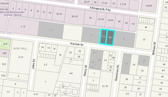
|
|
|
Subject site
|
|
29 Objector Properties (multiple
objectors in Nos 33 and 41 Harrow Street)
(1 objector outside of map)
|
é
North
|
BACKGROUND
History
One (1) previous planning permit
application was lodged and subsequently approved by Council in relation to the
subject site (the site). On 1st May 2017, Planning Permit
WH/2015/1148 was issued for Construction of a four storey building with
basement and a front fence. On 3rd July 2019, an approved extension
of time request was issued, extending the commencement expiry date to 1st May
2021, and the completion expiry date to 1st May 2023. This permit
remains active.
The Site and Surrounds
The Site
The site is located on the north
side of Harrow Street, between Henry Street and Glenmore Street in Box Hill. It
is rectangular in shape and is a consolidated block of 3 parcels (LOT 85 LP
2004 28B and LOTS 1-2 TP 678857 28B) with a frontage width of 33.22 metres, a
maximum depth of 36.53 metres, and a total site area of approximately
1214m².
The site is occupied by two
dwellings comprising a double storey dwelling on No. 37 Harrow Street and a
single storey dwelling on No 39 Harrow Street, including associated sheds and
ornamental trees. Both dwellings have vehicle crossovers from Harrow Street, as
well as access from the northern rear laneway for No 37 Harrow Street. There
are 2 street trees adjacent the site including an established paperbark tree
adjacent No 39 Harrow Street. The site has a gentle cross fall from south-east
to north-west of approximately 1.2 metres. The site has a rear laneway
providing access to the lots fronting both Harrow Street and Ellingworth Parade
to the north.
Zoned Residential Growth Zone
(RGZ2), the site is located within ‘Activity Precinct F’ (Southern
& Eastern Precincts), and ‘Built Form Precinct D’ (Mid-Rise
Commercial and Mixed Use Precincts) of the Box Hill Metropolitan Activity
Centre (‘MAC’), as identified in the Box Hill Structure Plan.
The Surrounds
Immediate Surrounds
· Land
north of the adjoining laneway is contained within the Commercial 1 Zone and
developed with two storey office and commercial buildings.
· To
the east, at 41 Harrow Street, is a three-storey apartment building, setback a
minimum of 5.13 metres from Harrow Street, 3.58 metres from the common side
boundary, and located on the northern boundary to the rear laneway.
· To
the west, at 31-35 Harrow Street, is a five storey mixed use (dwellings and
retail) building. This building is located on all property boundaries; and has
a maximum building height varying between 15.14 metres and 19.04 metres.
Parking is accessed via the northern rear laneway.
· Due
to Harrow Street being designated as a precinct for 3 to 4 storey high
development, the northern side of the street is evolving into apartment style
development with a number of 3 to 5 storey apartment buildings evident.
The southern side of the street is mainly developed with lower scale townhouse
development. However, located within Precinct B of the Box Hill Structure Plan,
the south side of Harrow Street will expect 3 storey apartment development
occurring in future.
Surrounding Area - Greater Urban
Context
The site is located within a Major
Development Precinct designated by the Box Hill Activity Centre Transit City
Structure Plan 2007. The Box Hill Metropolitan Activity Centre (MAC)
provides retail, education, office, civic, medical, community facilities,
entertainment, dining and recreational opportunities for the regional
population, as well as a hub for local community activities.
The subject site is located 370
metres from the Box Hill Train Station, which is serviced by Belgrave and
Lilydale train services. A bus interchange is also located at the Box Hill
Train Station, which is serviced by approximately twenty (20) major bus routes
and the 109 Tram Service towards the Melbourne CBD running along Whitehorse
Road. There are also major bus routes along Ellingworth Parade, William Street
and Rutland Road close to the site that link up to this mentioned major bus
interchange.
There are no major public reserves
close to the site. 50 metres west of the site is the Ellingworth car park. The
Box Hill Structure Plan identifies this land as ‘key open space’.
The Box Hill MAC is experiencing
significant redevelopment, with the following sites in the vicinity of the
subject land either approved or constructed:
· 9-11
Ellingworth Parade (WH-2014/43) – 12 storey office building
· 8
Ellingworth Parade (WH/2011/128) – 5 storey office / dwelling development
· 2-10
Harrow Street – 5 Storey public car park
· 15-21
Harrow Street (WH/2009/250) – 5 storey dwelling development
· 31-35
Harrow Street (WH/2011/566) – 5 storey dwelling development
· 22
Rutland Road (WH/2013/559) – 6 storey office / dwelling development
· 38
Rutland Road (WH/2019/440) – 13 storey office tower
· 545
Station Street (WH/2011/986) – 36 storey mixed use (retail and apartment)
tower (“Sky One”)
· 21
Ellingworth Parade (WH/2019/526) – 8 storey officer tower
There has also been demand for
residential hotels / residential serviced apartments with the Box Hill MAC as
follows:
· 12-14
Nelson Road – approved mixed use development part 19 and 20 storeys (61
metres).
· 702-706
Station Street – approved 13 storey residential hotel.
· 874-878
Whitehorse Road – approved 25 storey residential hotel.
· 3-5
Poplar Street & 837 Whitehorse Road – Approved 15, 31 and 20 level
high towers that include a residential hotel.
Planning Controls
Residential Growth Zone (RGZ2)
Pursuant to the table of uses under
Clause 32.07-2 of the RGZ2, a ‘Residential Hotel’ is a Section 2
(permit required) use, nested under ‘accommodation’. A planning
permit is also triggered under Clause 32.07-8 of the Scheme to construct a
building and / or construct or carry out works for a use in Section 2 of Clause
32.07-2.
As the proposed residential hotel
does not include the provision of dwellings and is not defined as an
‘apartment’ building under Clause 73.01, Clause 58 (Apartment
Developments) is not applicable. Consideration can be given to the general
principles of Clause 58 as part of this assessment as discussed later in this
report.
Pursuant to the Table of Uses at
Clause 32.07-2 of the RGZ2, a Food and Drinks Premises is a Section 2, permit
required use.
Pursuant to the Table of Uses at
Clause 32.07-2 of the RGZ2, an ‘office’ is a Section 2, permit
required land use, provided that it is ‘within 100 metres of a
commercial zone; must have the same street frontage as the land in the
commercial zone; and must have a leasable floor area not exceeding 250m²
in area’. A ‘retail premises’ is prohibited under Clause
32.07-2, other than ‘Food and drink premises’,
‘Market’, ‘Plant nursery’ and ‘Shop’. A
shop also must have the same street frontage to, and a 100 metre maximum
distance from, land in a commercial or mixed use zone.
There is Commercial 1 Zone (C1Z)
land that shares the same Harrow Street frontage, 150 metres west of the site,
while Mixed Use Zone (MUZ) land exists 281 metres west of the site, but not on
Harrow Street. The C1Z and MUZ land are both either located too far away from
the site, and/or do not share the same street frontage. As the mandatory
conditions of the zone cannot be satisfied, office, retail premises and shop
land uses are all prohibited under the RGZ, and cannot be supported as part of
this application.
As the proposed retail / office
leasable floor space is limited in scale, its deletion and use instead for
residential hotel-related purposes, will not affect the overall layout of the
residential hotel and can be addressed as a permit condition should this
application be approved.
Significant Landscape Overlay
– Schedule 9
Pursuant to Clause 42.03-2 of the
Scheme, a permit is required to construct a building or construct or carry out
works. This does not apply if a schedule to this overlay specifically states
that a permit is not required.
Section 3 under Schedule 9 to the
SLO states:
A permit is not required to
construct a building or carry out works provided the building or works are set
back at least 4 metres from the base of any tree protected under the provisions
of this schedule.
A permit is required to remove,
destroy or lop a tree.
This does not apply to:
• A
tree less than 5m in height and having a single trunk circumference of 1.0
metre or less at a height of one metre above ground level; or
• The
pruning of a tree for regeneration or ornamental shaping; or
• A
tree which is dead or dying or has become dangerous to the satisfaction of the
responsible authority; or
• A
tree outside the Minimum Street Setback in the Residential Growth Zone.
The proposed development is not
subject to any ‘minimum street setback’ and therefore no permit is
triggered for the removal of trees from the subject site.
Clauses 52.06 (Car Parking)
A permit is required under Clause
52.06 (Car Parking Provisions) to reduce the car parking requirements.
Clauses 52.34 (Bicycle
Facilities)
A permit is required under Clause
52.34 (Bicycle Facilities) to waive any of the requirements under this Clause.
The proposal results in a shortfall of the provision for bicycle spaces and end
of trip facilities, and will require a permit under this Clause.
PROPOSAL
The proposal seeks use and
buildings and works to construct a residential hotel (including associated food
and drink premise, retail/office and vegetation removal), and reduction of the
car and bicycle facility requirements.
Residential Hotel (Serviced
Apartments) and Associated Commercial Land Uses
The layout of the building is
primarily intended to function as serviced apartments. Eighty eight (88)
serviced apartments are proposed providing between 1 to 4 beds, along with bathrooms
and living areas in numerous suite configurations. Numerous suites include
private open space balconies.
The building configuration
comprises 6 levels of serviced apartments on top of 1 basement level. There
will be 440m² of associated commercial floor area, including a 71m²
space identified for both retail and office, a food and drink premises
(120m²) with external courtyard for seating, two conference rooms
(75m²) on the ground floor, and one conference room (89m²) on level
4. The basement will accommodate 29 car spaces, 9 bicycle spaces and refuse
area, accessed via the rear laneway. There is also a ground floor loading bay
serviced by the rear laneway, and communal terrace areas on levels 4 and 5.
Development (Buildings and
Works)
The proposed building would consist
of a six (6) storey, 19.99 metre high building, and would have minimum boundary
setbacks of 1.9 metres (front), 2 metres (west) to 3 metres (east) side
boundaries, 1 metre (rear).
The building will be constructed of
metal cladding and battens for external walls in either a dark or light grey
finish. Screened plant areas are shown on the roof level adjacent to the lift
overrun, with utility booster and meter boxes located within the front setback
area. Vertical and horizontal landscaping is provided throughout all
elevations/aspects of the building as part of the proposed building’s
urban design.
The proposal includes removal of
Tree 4 (Sweet Pittosporum, 5 metres) in the front setback, which is not
protected under the SLO9.
CONSULTATION
Public Notice
The application was advertised by
mail to the adjacent and nearby property owners and occupiers and by erecting a
notice on each lot as part of the site facing the Harrow Street frontage.
Following the advertising period 29 objections were received.
The issues raised in the objections
are summarised as follows:
· Building
Massing / scale
· Neighbourhood
Character
· Height
· Setbacks
· Traffic
/ Parking / Access / Safety
· Land
Use Composition
· Extent
of retail floor area
· Possible
bar
· Inappropriate
social behaviour (drinking related behaviour: noise (streetscape), crime,
rubbish, vandalism)
· Non-residential
pedestrian activity
· Overlooking
· Overshadowing
· Property
Devaluation
· Air
pollution
Consultation Forum
A Consultation Forum was held on
Tuesday 19th February 2020. Twelve (12) objectors attended the meeting, in
addition to Councillor Barker, planning officers and the applicant.
The Consultation Forum was chaired
by Councillor Barker and concerns/objections with the proposal were grouped
under broad categories with all parties afforded the opportunity to provide
commentary on each concern. The permit applicant was also given an opportunity
to respond to objector concerns.
The following additional objections
were raised:
· Illumination
/ light spill by night.
· Noise
(from eastern kitchen door and pathway to rear loading area, and external
seating within eastern court yard ancillary to food and drink premises).
· Trading
and delivery hours
· Access
to goods lift
· Land
use
· Waste
A number of potential resolutions
were discussed between parties however no agreements were reached on the night.
Without Prejudice Plans
Subsequent to the Consultation
Forum, on 26/3/2020 informal ‘without prejudice’ amended plans were
submitted by the applicant intended to address issues raised by both Council
officers and objectors. These informal amended plans have been circulated to
all objectors and Ward Councillors. A summary of the changes has been provided
by the applicant, and the following key changes apply:
· Terraces 101 &
120 have been removed
· The Level 4
conference room and terrace has been removed and replaced with serviced
apartments and serviced apartment terraces. Level 4 now has 13 serviced
apartments (increase of 1 serviced apartment)
· The Level 5 street
setback has been increased.
· Level 5 now has
seven serviced apartments (reduction of one serviced apartment).
· Ceiling heights of
Levels 1 to 5 now reduced by between 100mm and 300mm
· The total wall
height on the boundary of Harrow Street has now been reduced by 900mm (17.1
metres reduced to 16.4 metres).
· The maximum
building height has been reduced from 19.99 metres down to 19.49 metres.
Objectors were given the
opportunity to provide additional comment on the amended documentation.
Following this period, there were no new issues raised. Whilst the without
prejudice plans were not advertised, they will form the basis of the assessment
for this report.
Referrals
External
|
Department
of Transport (DoT)
|
The application was referred to the Department of
Transport (DoT) under Section 66.02-11 of the Planning Scheme who advise that
they do not object to the proposal with no conditions required.
|
Internal
|
Transport Engineer
|
Council’s Transport Engineering team have
reviewed the proposal and object to the proposal, unless 4 outstanding issues
are addressed. They include provision of sufficient on-site parking for the
food and drink premises, an onsite pick up or drop off area, and a 6.1 metre
wide passing area to avoid off site laneway vehicle queuing, to meet Clause
52.06 of the Planning Scheme.
|
|
Waste Engineer
|
Council’s Waste Engineering team have reviewed
the proposal and provided unconditional support.
|
|
Assets Engineer
|
Council’s Asset Engineering team have reviewed
the proposal and do not object to the proposal, subject to standard
conditions and notes.
|
|
ESD Officer
|
Council’s ESD officer has reviewed the proposal
and confirmed that the plans, the Sustainable Management Plan, the BESS
assessment and integrated water management plan currently do not comply with
the ESD provision of the Planning Scheme, particularly Clause 22.10. Proposed
conditions have been provided to address non-compliances.
|
|
Design and Construction
|
Council’s Design and Construction officer has
reviewed the proposal and has provided consent subject to the conditional
submission of a streetscape plan which ensures that the building can
adequately present to the public realm of Harrow Street.
|
DISCUSSION
Consistency with Planning Policy
Framework (PPF) and Local Planning Policy Framework (LPPF)
In terms of
State planning policy, the subject site, being located within the Box Hill
Metropolitan Activity Centre (MAC), represents a strategic redevelopment opportunity
to deliver higher density residential uses and complementary commercial
activity.
The development is
consistent with both State and Local Policies such as Clauses 16.01-1S
(Integrated Housing), 17.01-1R (Diversified Economy – Metropolitan Melbourne),
18.01-1S (Land Use and Transport Planning) which encourages
concentration of development and employment opportunities in and around
activity centres and intensifying development on sites well connected to public
transport. This enables more efficient use of existing infrastructure.
The proposed
development will be located within the Box Hill Metropolitan Activity Centre
(MAC) close to employment corridors and public transport in accordance with
Clauses 11.03-1S (Activity Centre Planning) and Clause
18 (Transport).
The proposed development will also
provide for additional commercial services that offer community benefit within
existing or planned activity centres in accordance with Clause 17 (Economic
Development). Clause 21.07 (Economic Development), also seeks
to increase the number and diversity of employment opportunities, specifically
identifying retail and office activities as an area where opportunities have
been created, particularly in redevelopment sites.
While this may be
the case, the subject site is limited in its ability to provide a variety of
land uses given the residential zoning in which many commercial uses are either
capped in terms of the square meterage that can be proposed, or are outright
prohibited. This is relevant to the site given that the proposed office and
retail premises land uses are prohibited under the RGZ2, as discussed in detail
later in this report.
Clause 22.06 (Activity Centres Policy) includes objectives
to ensure that new development maintains and enhances the role of the activity
centre as a community focus and to improve the appearance and amenity of the
activity centre. The subject site is included within a
Substantial Change area which will provide for housing growth with increased
densities, in accordance with the Box Hill Transit City Activity Centre
Structure Plan 2007 (Box Hill Structure Plan).
The policy under
Clause 22.07 – Box Hill Metropolitan Activity Centre promotes
design excellence in new developments through encouraging built form which
provides for increased height, but which is sensitive to adjoining residential
areas and provides activated and functional interfaces with the public realm to
enhance walkability.
Clause 22.05 recognises
non-residential land uses that have potential to adversely impact upon the
amenity of residential areas if they are poorly designed or located. This
policy recognises that there is also a legitimate need for non-residential uses
in residential areas to serve the needs of the local community. Although
classed as a ‘residential building’, a residential hotel is
commercially managed and operated. The residential hotel is appropriately located
within the Box Hill MAC and subject to permit conditions, will be compatible to
the role and function of Harrow Street within the MAC as defined by the
Structure Plan below. All amenity impacts can be suitably addressed as permit
conditions as discussed in detail later in this report.
The Box Hill Transit City
Activity Centre Structure Plan is referenced in Clause 22.07 (Box Hill
Central Activities Area Policy). The subject site is located within Activity
Precinct F (Southern & Eastern Precincts) and Built Form Precinct D
(Mid-rise Commercial and Mixed Use Precincts). Activity Precinct F is
identified for: accommodation of growth in the local supply of office space;
continuation of the precinct’s role in supporting some retail activity;
office and retail activities that respond to prominent Whitehorse Road and
Station Street frontages; mixed uses including higher density residential as a
buffer to established residential precincts.
Being located
within the MAC ‘Activity Precinct F’, the proposed development is
adequately located in principal. The subject site and its immediate environs
are earmarked for a substantially increased shift in the diversity and density
of use and development in future. This area therefore represents a good
opportunity to deliver the proposed mixed-use development, while managing
external amenity impacts to the surrounding residential neighbourhood and
identified key public open space areas nearby.
A 4-storey
preferred height limit is given to this MAC Precinct D, while it is expected
that building height must transition down to the ‘Low-Rise, Higher
Density Residential Precinct B’ for properties on the south side of
Harrow Street (3-storey preferred height limit). This will be discussed in
detail under ‘Urban Context and Building Massing’ later in this
report.
The proposal at
6 stories high (19.4 metres) does not represent a building mass that will
appropriately fit within Built Form Precinct D, nor will it provide adequate
transitional building height down to the lower order residential precinct (MAC
Built Form Precinct B). The proposed building will also stand above both
adjoining 3 stories and 5 storey apartment buildings, and forward of the
adjoining 3 storey apartment at 41 Harrow Street in particular. This will give
the proposed building a dominant appearance within the streetscape.
However, as
expanded on later in this report, the proposed street setbacks have struck an
acceptable balance between the expectations of the Structure Plan and the existing
prevailing street setbacks. As also discussed later in the report, a reduction
in building height particularly including the loss of the fifth floor level can
address all building height, scale and massing issues and amenity impacts via
permit conditions without resulting a major transformation of the proposal.
Overall, the nature and location of
the proposed use and development aligns with the expectations of Planning
Policy Framework and Local Planning Policy Framework in terms of supporting the
role of diversifying the MAC from an economic and street activation
perspective. All relevant amenity impacts can be adequately managed via permit
conditions should this application be approved.
Urban
Context
Building Height, Massing and
Scale
From an
existing urban context perspective, the site is located within the Box Hill
MAC, but also within an enclosed residential streetscape context where a higher
level of amenity exists within the public realm, despite the recent emergence
of larger scale residential development occurring in the area.
The RGZ2 provides the first
layering of preferred character expectations by setting expectations of
substantial change residential development up to four storeys in height
(between 13.5 metres and 14.5 metres high based on land slope). There is a
clear indication that density and built form will be increased, and that the
departure from the existing character will be substantial. Located within the
Box Hill MAC, the proposal is also subject to the expectations of the Structure
Plan.
Like the RGZ2, a preferred building
height of 4 stories (14 metres high) applies, reflected in the Built Form
Activity Precinct D ‘Mid-rise Commercial and Mixed Use Precincts’.
It is important to recognise that these maximum height limits are preferred
only. The location of the proposed building is a key determining factor in how
its height ultimately transitions down from the MAC core (no specific height
limit), to lower order MAC precincts and residential areas. The most immediate
lower order precinct south of the site is the ‘Low-Rise,
Higher Density Residential Precinct B’ (3 storey preferred height
limit).
One key indicator within the
surrounding transitional area between the MAC core and residential areas is the
heights of buildings constructed and approved as part of the surrounding urban
context. Another key indicator is the extent of overshadow cast into (a) key
public spaces, (b) peripheral residential precincts and (c), residential areas
outside the Activity Centre.
In this instance, the proposed
development will not overshadow the nearest: (a) key public space (Ellingworth
carpark, 20-24 Ellingworth Parade, 50 metres west of the site), (b) peripheral
residential precinct (Precinct A, east of Glenmore Street approximately 31 metres
south-east of the site) and (c), residential area outside the MAC (east of
William Street, approximately 110 metres east of the site). Consequently, the
impact of overshadow will have no genuine influence when determining
appropriate transitional building height.
When reviewing
the existing public realm, it is acknowledged that 5 storey buildings have
already been constructed on Harrow Street, west of the site at Nos 2-10 (public
carpark), 15-21 (apartment building), and 31-35 (apartment building). 8
Ellingworth Parade (8 storey building) is also located within the same Built
Form Activity Precinct D ‘Mid-rise Commercial and Mixed Use
Precincts’.
There have also
been a number of recently constructed apartment buildings approved east of the
site on Harrow Street varying between 3 and 4 stories in height within the same
Built Form precinct. To put this into perspective, there is no recently
approved or constructed development within the southern portions of Major
Development Precinct F interfacing or within immediate proximity to the site
that could inform how the proposed development should transition.
The recently
approved 8 storey building at 21 Ellingworth Parade has set the mark for
building height within the centre of Activity Precinct F and Built Form
‘Major Development Precinct’ F, which also transitions down to the
key public space of the Ellingworth carpark. This building is however too
removed from the site, situated 100 metres away to the north-west. This
approved building can only partially inform building height transitioning down
from the Major Development Precinct to the Mid-rise Commercial and Mixed Use
Precincts’, which the site is located within.
Also
acknowledged is the recently approved 13 storey building at 38 Rutland Road
(100 metres north of the site) that sets transitional height expectations for
development closer to the railway corridor. The partly constructed 12 storey
building at 9-11 Ellingworth Parade (170 metres north-west of the site) will
also set transitional building height expectations closer to the MAC core,
immediately east of Station Street. Both these buildings again are well removed
from the context of the site from a building height perspective. With all
factors considered above, it is considered that the public realm reflects a 4
to 5 storey high development for the site.
Upper floor
recession above 3 to 4 stories from lower floors is a common expectation of the
Structure Plan. This is to create a street wall podium that provides for an
appropriate human scale experience at street level. The ‘Mid-Rise
Commercial and Mixed Use Precinct’ does not include a preference for
upper floor recession as buildings are not expected to exceed 4 stories.
From this perspective, the proposal could align with the public realm and
expectations of the Structure Plan, provided that only 4 stories are visible to
the street (fifth floor genuinely recessed off lower floor levels).
The proposed 6
storey building will be 5 stories in appearance from street view with the sixth
floor recessed from lower floor levels, which does not align with the
surrounding public realm, nor the expectations of the RGZ or the Structure
Plan. The applicant has also relied upon multiple vertical and horizontal
landscape themes, extensive balcony treatment and transitioning building height
down the east elevation, to reduce building mass. The effect of these measures
will improve visual interest, but will not sufficiently reduce the dominance of
the overall building height, scale andmassing from the street. This proposed
building sits well above the 3 to 5 storey high buildings on the north side of
Harrow Street, and the 3 storey buildings expected on the south side of Harrow
Street.
The reduction
in height by one floor will resolve this issue and will not result in requiring
a major redesign to the proposed layout. As such, it is recommended that the
fifth floor be deleted. The sixth floor then becomes the fifth floor, being already
recessed from street view. The resulting 5 storey building, presenting as 4
stories to Harrow Street, would sufficiently fit within the surrounding public
realm, the preferred character of Harrow Street, and align with the Structure
Plan. The dominance of the building from its mass, scale and height can be
sufficiently relieved from a noticeable loss in building height as a result of
the deletion of the fifth floor as discussed. From this perspective, subject to
permit conditions, the issues relating to height, scale and massing of the
proposed building can be adequately resolved.
Street
Setbacks
The Structure
Plan encourages front street setbacks to activate street frontages with (a) the
use of glazing at ground and first floor levels for transparency and
surveillance purposes and (b) encourage the provision of some ancillary ground
floor retail land uses. The public realm concerning both adjoining apartment
buildings provides a slight increase in the street setback expectations from
the Structure plan. While the west adjoining apartment building (No 31-35
Harrow Street) has a front setback of zero metres, the eastern adjoining
apartment building (No 41 Harrow Street) has an increased front setback varied
between 5.1 metres and 7.4 metres.
The proposed development
provides an appropriate balance between the zero metre front boundary setback
expectations the Structure Plan, and the existing prevailing street setback in
Harrow Street with front setbacks varying between 1.9 metres and 4.1 metres. It
is acknowledged that the east adjoining 3 storey apartment building at 41
Harrow Street is unlikely to be redeveloped in future, meaning that the
proposed building’s projection forward of this adjoining building will
remain for years to come.
However, the
lesser zero metre front setback of the west adjoining 5 storey apartment
building at 31-35 Harrow Street will provide the backdrop to the proposed
building for west-bound traffic passing the site. From this perspective,
subject to conditions of height reduction as discussed earlier, the dominance
of the building, will not be excessive or undermine the building delivering an
appropriate building massing of human scale from a pedestrian street level
experience.
The landscaping
will complement and visually softening the architectural themes of the front
building façade. The landscaping will not screen the building as a whole
to the street frontage. Consequently, subject to conditions of reducing overall
building height, mass and scale as discussed earlier, this will result in the
building having attractive, visible main entries to all proposed land uses on
site.
Public Realm
Shop and business signage opportunity
Erecting signage on the front
building façade can often be an afterthought and have the potential to
conflict with the building’s urban design in due course, at times looking
‘cluttered’. It is a priority the urban design incorporate a
prescribed space where future signage can be located to better integrate with,
not undermine or discredit, the architectural appearance of the
building’s front facade. This issue can be addressed as a permit
condition should this application be ultimately approved.
Vehicular Access, car
parking, bin enclosures and service facilities
·
The Structure Plan encourages vehicular
access, bin enclosures and service facilities to largely be provided to the
rear laneway if applicable, and/or in a basement into car parking areas, being
out of sight to the main street public realm. This is to assist in creating
safety and better activated street frontages. Subject to permit conditions, the
refuse area, all car parking, loading and the drop off / pick up facility can
be provided in the basement and/or at the rear of the building accessed via the
rear laneway away from the site’s frontage. A limited supply of service
and utility boxes are provided in the front setback, but are excessive in their
footprint and appearance.
·
Public Realm Construction works
Despite the
landscape works proposed within the front setback area, there are also
requirements that relate to carrying out pavement construction within the
public realm between the front building and the back of road kerb, in
accordance with the Box Hill Urban Realm Treatment Guidelines (BHURT), to the
satisfaction of Council’s Design and Construct Team. This detail is
normally provided as part of a streetscape plan that can be addressed as a
permit condition, should this application ultimately be approved.
Land Uses
As discussed earlier, the site is located
within the Box Hill Metropolitan Activity Centre (MAC) which is of importance
not only to the municipality, but also to the broader metropolitan region given
its capacity for change and connections to other Activity Centres, residential
areas and multiple public transport options.
The residential hotel is not a
modest addition of commercial activity within the RGZ, but aligns with the
expectations of the Structure Plan in diversifying land use within the MAC. The
nature of this land use is acceptable provided conditions that require the
operation of this residential hotel to mitigate any unreasonable amenity
impacts through noise, light-spill, odours and storage of goods/waste. These
conditions would provide for an outcome which is generally consistent with the
policy under Clause 22.05 (Non-residential uses in residential areas).
From a noise generation
perspective, non-residential activity (including outdoor seating, loading bay
and footpaths), and exhaust fans must be compliant with the SEPP N-1 EPA
standard for commercial noise, while ensuring the exhaust fans are
appropriately located to minimise noise spill, can both be addressed as permit
conditions should this application be approved.
The introduction of a
‘lighting plan’ via a permit condition will also ensure lighting at
appropriate levels to illuminate the laneway and northern footpath of Harrow
Street while protecting the amenity of residences on either side of the
laneway, the main road and adjoining apartment buildings, from excessive light
spill. This will provide a greater safety and security of residents.
Overall, the proposed development
would provide acceptable outcomes to both the Harrow Street and laneway
interfaces, through appropriately scaled and legible entrance points and improvements
to the safety and presentation of the lane. The traffic activity generated from
the proposed residential hotel will likely be greater in intensity and
frequency than the apartment development and detached dwellings within Harrow
Street, but comparable to the public carpark west of the site at No 2-10 Harrow
Street.
The proposed development does not
provide an on-site drop off-pick up area that will potentially disrupt parking
and traffic conditions on Harrow Street, and is not a preferred outcome. This
is an issue also recognised by Council’s Transport Engineer. It is
considered that the ground floor rear loading bay, currently proposed to
service the kitchen of the food and drink premises, can also function as an
onsite drop off / pick up facility for guests and patrons.
The Car Parking Management Plan
sets out clear expectations of managing both roles and minimising traffic
disturbance in the rear laneway, while a direct pedestrian connection into the
rear of the building can greatly reduce noise generation to adjoining and
nearby residential properties. These measures can be addressed as permit
conditions should this application be approved and in turn, address the issues
raised by objectors and Council’s Transport Engineer.
The proposed ancillary food and
drink retail premises will likely attract small gatherings of patrons during
key meal periods, with the greater anticipated patronage from the users of the
hotel itself, while the ground floor conference rooms will not be available to
the public as they are strictly ancillary to the residential hotel. Again
permit conditions can require the operation of the food and drink premise in
particular to avoid unreasonable amenity impacts.
As mentioned earlier, both the
proposed office and retail premises are prohibited under the RGZ2 and must be
deleted, converted back into floor used for residential hotel-related purposes.
This can be addressed as a permit condition should this application be
approved.
Overall, despite introducing
non-residential activity to a residential street context within the MAC, all
amenity impacts can be sufficiently resolved via permit conditions to ensure
that the proposed residential hotel’s location receives full policy
support under the Planning Scheme.
Section 173 Agreement
As stated earlier, a residential
hotel is not bound by the provisions of Clause 58 (Apartment Development) as
part of this assessment. This has resulted in numerous non-compliances with
standards pertaining to internal amenity that could be reasonably expected to
be met in permanent dwellings. For example, elements such as providing adequate
bedroom, shower and private open space dimensions, adequate communal area, deep
soil planting, external storage, energy efficiency outcomes and waste access, have
not been met in accordance with numerous Standards of Clause 58.
Should this application be
ultimately approved, this issue can be addressed through permit conditions
requiring a Section 173 Agreement to be registered to the land to ensure that
the residential hotel (a) is operated by one management entity/body and (b), to
exclude the use of the hotel suites as dwellings in the future.
External Amenity
Overshadow / Overlooking /
Daylight access
The most applicable policy is the
Structure Plan, which focuses on protecting key public spaces, peripheral
residential precincts within the MAC, and residential areas outside the MAC
from overshadow during the winter solstice (June 22nd). The winter
solstice shadow diagrams submitted demonstrate that the proposed building will
have no overshadow impacts on the Ellingworth Carpark (nearest key public space
west of the site), to any peripheral residential precinct within the MAC or any
residential areas outside the MAC. The proposal therefore addresses all the key
external amenity impacts covered within Precinct D of the Structure Plan.
Unfortunately, there is a lack of
policy requirements in the Planning Scheme addressing external overshadowing,
overlooking and daylight access to buildings adjoining and immediately opposite
on the south side of Harrow Street. Despite the extent of overshadow caused by
the proposed development to those nearest properties, the proposal has achieved
compliance against all applicable requirements of the Structure Plan, the RGZ2
and Clause 58 from an overshadowing perspective.
The RGZ2 includes various amenity
Standards of Res Code to be met when a site interfaces with a lower-order
residential zone, which does not apply to the site in this instance. Clause 58
seeks to limit views into proposed and existing buildings, but is silent on
protecting adjoining sites from external overshadow or daylighting impacts. The
proposal has two sensitive side boundary interfaces by abutting apartment
buildings to the east and west. Both apartment buildings adjoining to the east
(41 Harrow Street, 3 storey building) and west (31-35 Harrow Street, 5 storey
building) have numerous side-facing windows and POS balcony treatment sited up
to 1 metre from the respective common boundaries with the site.
Proposed screening devices
(vertical screens, obscured glazing and planter boxes) are included to ensure
that any potential overlooking generated from side facing habitable room
windows are mitigated.
To ensure that equitable
development opportunity of adjoining properties are protected and to
subsequently protect these properties from external amenity impacts, Clause 58
and the Structure Plan both encourage proposed buildings to be sited onto side
boundaries. If not located onto side boundaries, the industry accepted setback
is 4.5 metres (to provide an overall 9 metre setback between habitable room
windows of both adjoining buildings to mitigate against overlooking, but to
provide sufficient spacing between buildings to allow for adequate
daylighting). Both adjoining apartment buildings are already built,
unlikely to be redeveloped, and their development potential consequently
realised. The 4.5 metre side boundary setback is not therefore applicable in
this instance.
Wind Impact
A Wind Impact
Assessment report has been required for submission and approval by the
Responsible Authority prior to the endorsement of plans as discussed earlier in
this report.
Internal Amenity
Environmentally
Sustainable Development (ESD)
Redevelopment
of the site, located in an existing residential area, makes more efficient use
of existing infrastructure and services, and the proximity of the subject site
to numerous public transport modes which reduce employees and visitors from
relying on private vehicles. Policy at Clauses 15.02 (Sustainable
Development), 15.02-1S (Energy and Resource Efficiency), 21.05, (Environment)
and 22.10 (Environmentally Sustainable Development) of the Planning Scheme,
encourage ecologically sustainable development, with regard to water and energy
efficiency, building construction and ongoing management.
Council’s
ESD Officer has advised that the submitted Sustainability Management Plan (SMP)
has not yet achieved compliance with the Environmental Sustainable Design (ESD)
standards contained within Clause 22.10. However, Council’s ESD officer
has also confirmed that these outstanding matters can be addressed as permit
conditions should the application ultimately be approved.
Car Parking, Traffic &
Access
The site is located within the Box
Hill Central MAC and is therefore subject to the Box Hill Activity Centre
Parking Overlay (Clause 45.09). With the retail/office required to be deleted
as a permit condition, the resulting proposal will require the following
parking provision for the proposed development:
|
Land Use
|
Number
/ Area
|
Statutory
Parking Rate
|
Required Car Spaces
|
Proposed
Car Spaces
|
Difference
|
|
Accommodation (Residential
hotel / Serviced Apartments)
|
88
|
To the satisfaction of the
Responsible Authority [0.5 spaces per room]
|
[44]
|
28
|
[-16]
|
|
Food and Drink
|
120m2
|
3.5 spaces per 100m2
[2 spaces per 100m2]
|
7 [4]
|
1
|
-6 [-3]
|
|
Total Car Parking
|
|
|
51
|
29
|
-22 [-19]
|
Table 1: Parking provision
and requirements. Figures in brackets ‘[...]’ indicates the
modified empirical parking requirement based on a reduced parking rates for
both residential hotels and retail premises being deemed acceptable by Council’s
Transport Engineering officers.
As stated above, the required 51
spaces under Clause 45.09 will result in a shortfall under the Planning Scheme
of 22 spaces, and a shortfall of 19 spaces based on the empirical rates adopted
by Council’s Transport team. The car parking rate for the residential
hotel is to the satisfaction of Council under Clause 52.06. Council’s
Transport Engineer has adopted a parking rate of 0.5 spaces per patron, which
has been adopted by other serviced apartment building in Box Hill. The applicant’s
proposed parking provision is based on a reduced parking rate of 0.3 spaces per
patrons, which has resulted in the parking shortfall of 16 spaces under the
empirical rate.
Importantly, Council’s
Transport Engineer does however support the traffic generated indicating that
levels ‘will be small and can be accommodated by the surrounding road
network without adverse impacts. The basement car park will be directly
accessed via the laneway at the rear of the subject site which is considered
satisfactory.’
Additionally, Council’s
Transport Engineer has raised concerns that no on-site drop off / pick up
facility is provided. As discussed earlier, the preference is to provide an
on-site drop-off / pick up facility to minimise the impact to existing traffic
conditions in Harrow Street, in the form of the rear loading bay via a permit
condition if this application is approved. The Car Parking Management Plan can
set the expectations for how both purposes will be managed together. However,
given that any potential conflict will occur to the rear of the site in a
double width laneway where vehicles can pass and not be inconvenienced,
addressing this issue as a permit condition is an acceptable outcome, should
this application be approved.
Overall, it is acknowledged that
the traffic generation impacts are not detrimental to Harrow Street and that
the conditioned on-site drop off-pick up facility from the rear loading bay
will draw short term parking demands away from Harrow Street. It is therefore
considered that despite exceeding the adopted empirical rate of Council’s
Transport Engineer, the resulting car parking shortfall will not have a
detrimental impact to the parking and traffic conditions of the external street
network, namely Harrow Street. It is also considered that any amenity traffic
and parking-related impacts can be mitigated via permit conditions should this
application be approved.
Concerning the food and drink
premises, Council’s Transport Engineer requires that 2 additional car
spaces be provided for staff who will require long-term parking, which is not
compatible with the Harrow Street two-hour parking restrictions. This issue can
be addressed as a condition of approval should this application be approved.
Notwithstanding, Council’s
Transport Engineer has also supported the ramp gradients, turning areas and
widths of the proposed access. The proposed ‘stop-go’ traffic
management devices at the top and bottom of the basement ramp will adequately
address visibility and safety related traffic issues internal to the site
provided that there is also the potential for external vehicle queuing on the
laneway, which must be minimised.
Providing a 6.1 metre wide passing
area at the ramp entry from the rear boundary, complete with adequate
sightlines where the accessway meets the laneway, will address the issue raised
by Council’s Transport Engineer, and achieve compliance with Clause
52.06. These measures can be addressed as permit conditions should this
application be approved.
It is also noted that the ‘stop-go’
device at the top of the accessway ramp projecting into the laneway must be
fully located on site, which can be addressed as a permit condition.
Bicycle Facilities –
Clause 52.34
Nine bicycle spaces are proposed
within the basement floor level, resulting in a shortfall of 11 bicycle spaces
(20 spaces required or 10 staff and 10 visitor spaces in accordance with Clause
52.34). Additionally, no shower or change room facilities are provided (2
showers and 1 change room per shower required under Clause 52.34). A waiver of
the bicycle facilities requirements (provision for bicycle, shower and change
rooms) is therefore required.
Although within the MAC, the site
is separated from the MAC core by the major road of Station Street. A stronger
provision of bicycle spaces and end of trip facilities for visitors is
therefore encouraged. At least 6 additional visitor bicycle spaces in the front
setback area or ground floor lobby can be provided to partially reduce this
shortfall to 5 spaces, instead of 11 spaces. This issue can be addressed as a
permit condition should this application be approved.
Waste
Collection
Council’s
Waste Engineers have consented to the proposal in accordance with submitted
Waste Management Plan (WMP) indicating that the refuse area is of sufficient
capacity to support the residential hotel and associated retail/office land
uses.
Council’s
transport engineer has not supported the proposed 2.4 metre minimum ramp head
clearance, which should be at least 2.8 metres high to adequately enable waste
vehicles to enter and exit the basement safely. The above issues can however be
addressed as permit conditions should this application ultimately be approved.
Integrated
Public Transport Planning
Clause 66.02-11
requires the land to be referred to the Head of Transport for Victoria (TfV).
TfV has since been consolidated under the Department of Transport (DoT), who
has reviewed the application and provided unconditional consent.
Objections
Building
Mass / Scale / Setbacks
This key issue
has been discussed in detail earlier in the report. No changes have been
recommended to the proposed building boundary setbacks, as the proposed
building reflects the setbacks of both adjoining apartment buildings, and
achieves general policy support under the Planning Scheme, and particularly
with the Structure Plan.
Traffic / Parking / Access /
Safety
Objection grounds have acknowledged
the parking restrictions as well as the already saturated parking conditions on
Harrow Street; the absence of a proposed on-site drop off / pick up facility;
and pedestrian safety issues resulting from traffic and parking. All issues
have been discussed in detail earlier in this report.
Land Use
Objection
grounds indicate that there is too much retail floor space proposed, which
could lead to future licenced premises attracting non-residential pedestrian
activity and lead to inappropriate, alcohol influenced behaviour. As indicated
earlier, both office and retail premises land uses are prohibited and must be
converted back into residential hotel purposes to comply with the RGZ2 via
permit conditions should this application be approved..
As discussed
earlier, the proposed food and drink premises is limited in floor area and
aligned with both the Structure Plan and the RGZ, which both encourage small
amounts of retail use within a residential streetscape context.
Noise
As stated
earlier, the operation and management of non-residential activity (including
outdoor seating, loading bay, footpaths and exhaust fans) can be addressed via
permit conditions to achieve general compliance with Clause 22.05 (Non-residential
uses in residential areas).
Also
recommended was a direct pedestrian connection from the loading bay / drop
off-pick up facility and deletion of the eastern kitchen door associated with
the food and drink premise. These conditional measures will greatly reduce
noise impacts generated from site particularly to the eastern adjoining
apartment building at 41 Harrow Street.
The CMP would also
address noise impacts during the construction phase in line with the relevant
requirements. This document must be provided to and approved by the responsible
authority prior to commencement of any works.
Overlooking
Issues around
overlooking have been discussed earlier in this report and found that the
building’s setbacks are adequate to protect the amenity of the
surrounding area and neighbouring lots. This has been discussed in detail
earlier in this report.
Overshadowing/loss
of sunlight;
As stated
earlier, an acceptable level of compliance with relevant policy on this
external amenity issue, particularly concerning the Structure Plan and the
RGZ2.
Impact on
property values
The devaluation
of property values is not an issue identified in the planning scheme, nor is a
relevant planning consideration as commonly confirmed by VCAT.
Associated
pollution impacts;
The development
does not propose any uses that include any industrial-related activities which
are typically associated with possible pollution/emission impacts.
Trading Hours and Unreasonable
light spill
A permit condition can be included
to restrict trading hours for the food and drink premises to no later than
10:30pm to address this issue, should this application be approved.
Concerning unreasonable light spill
beyond property boundaries, a permit condition can be added to ensure that all lighting is of a limited intensity and appropriately baffled to
avoid direct light or glare emissions outside the site, to resolve this issue.
Access to Goods Lift
The functionality of the goods lift
has no bearing from an amenity perspective. It is acknowledged that the goods
lift is adjacent to the residential hotel lift as part of the ‘lift
core’. There will be no noise related issues with the location of the
goods lift, or visual amenity given that the lift overrun is central enough
within the building footprint not to dominate any aspect of the building from
the street or boundary interfaces.
CONCLUSION
The proposal for use and buildings
and works to construct a residential hotel (including associated food and drink
premise and vegetation removal), and reduction of the car and bicycle
requirements is an adequate response that satisfies the relevant provisions
contained within the Whitehorse Planning Scheme, including the State and Local
Planning Policies and the Residential Growth Zone (RGZ2).
Subject to the conditions discussed
throughout this report, the proposed building is considered to provide a level
of intensification envisaged under the guidance of the Residential Growth Zone
and Structure Plan (2007) and achieves an acceptable level of architectural
quality to justify the built form.
Subject to conditions, the proposal
provides for a mixture of uses consistent with the policies applicable for the
Structure Plan and RGZ2 in the Box Hill MAC. The building has been
designed to respond to the site’s varying interfaces, to provide an
adequate level of amenity protection for future residents and to activate the
street frontages.
A total of 29 objections were
received as a result of public notice and all of the issues raised have been
discussed as required.
It is considered that the
application should be approved.
Attachment
1 Without
Prejudice Plans 
2 Advertised
Plans 
Council Minutes 25
May 2020
9.1.4 13-25
Strabane Avenue, Mont Albert North: Buildings and works for the staged
redevelopment and extension of the existing residential aged care facility and
associated tree removal and lopping
FILE NUMBER: WH/2019/812
ATTACHMENT
SUMMARY
This application was advertised,
and a total of 15 objections were received. The objections raised issues with
amenity impacts, car parking, traffic, neighbourhood character, landscaping,
internal amenity and discrepancies in the submitted documents. A Consultation
Forum was held on 18 February, 2020 chaired by Councillor Barker, at which the
issues were explored, however no resolution was reached between the parties.
The applicant lodged a Section 79 Appeal (failure to
determine within prescribed time frame) with VCAT on 12 March, 2020. This
report assesses the application against the relevant provisions of the
Whitehorse Planning Scheme, as well as the objector concerns. It is
recommended that this application is supported, subject to conditions.
|
Council Resolution
Moved by Cr Barker, Seconded by Cr Liu
That Council:
A Being the Responsible Authority, having
caused Application WH/2019/812 for 13-25 Strabane Avenue, MONT ALBERT NORTH
(Lots 1 of TP 171463M, TP 171464K, TP 171465H, TP 171466F and TP 171467D) to
be advertised and having received and noted the objections is of the opinion
that the granting of a Planning Permit for the Buildings and works for the
staged redevelopment and extension of the existing residential aged care
facility and associated tree removal and lopping is acceptable and should not
unreasonably impact the amenity of adjacent properties..
B Has formed a position to support the
application in relation to the land described as 13-25 Strabane Avenue, MONT
ALBERT NORTH (Lots 1 of TP 171463M, TP 171464K, TP 171465H, TP 171466F and TP
171467D) for the Buildings and works for the staged redevelopment and
extension of the existing residential aged care facility and associated tree
removal and lopping, and notification to be given to VCAT, subject to the
following conditions:
1. Before
the development tarts, or vegetation is removed, amended plans for each stage
must be submitted to and approved by the Responsible Authority in a digital
format. When approved, the plans will be endorsed and will then form
part of the permit. The plans must be drawn to scale, with dimensions,
and be generally in accordance with the plans submitted with the application
but modified to show:
a) First
and second floor balconies on the south elevation that are located within 9
metres of the south boundary to be screened to 1.7 metres above the finished
floor level, in accordance with the requirements of Clause 53.17.
b) The
rendered balustrades of balconies at the eastern façade to be replaced
with frosted glass consistent with other balustrades on the building.
c) The
façade detailing to be amended to create more vertical elements in the
façade and a more varied skyline.
d) The
metal picket front fence at the north-west corner of the lot to be relocated
southwards to adjacent to the north side of the pedestrian path in the
frontage.
e) The
main pedestrian entrance door to be more prominently expressed architecturally,
in order to assist way finding.
f) Temporary
pedestrian building entrance for Stage 1 from Strabane Avenue;
g) The
rain garden relocated to be east of the semi-circular accessway.
h) The
locations of Tree Protection Zones described in condition 6, with all
nominated trees clearly identified and numbered on both ground floor plan and
landscape plan, and the requirements of conditions 6 and 7 to be annotated on
the development and landscape plans.
i) The
location of all service trenches to serve the dwellings (for example: gas,
water, electricity, stormwater, sewerage, telecommunications), including the
extent of trenching required in easements over adjoining lots (if any) and
the locations of protected trees within 4 metres of these trenches (if any).
The service trenches must be located and dug (including boring or hand
digging) to ensure that protected trees are not damaged, to the satisfaction
of the Responsible Authority.
j) Development
plans to reflect all sustainability features indicated in the amended
Sustainability Management Plan (SMP) required by condition
17. Where features cannot be visually shown, include a notes table
providing details of the requirements (i.e. energy and water efficiency
ratings for heating/cooling systems and plumbing fixtures, etc.).
k) Development
plans to reflect requirements of amended Waste Management Plan (WMP) required
by condition 19.
l) Notation
on site plans indicating that all obscured glazing be manufactured obscured
glass. Obscure film being applied to clear glazing will not be accepted.
m) Landscape
Plan in accordance with Condition 3, including the following:
i. No
trees to be planted within the easement, and the realignment of the
pedestrian path along the rear boundary in order to maintain reasonable separation
between trees and the building.
ii. The
planting of additional upper canopy trees within the site frontage, clear of
the canopies of existing trees.
iii. Canopy
trees to be positioned, or be species such that no more than 25% of the
mature canopy will overhang neighbouring residential properties.
iv. The
internal courtyard areas and communal upper level terraces to:
§ Be provided with
circular walking routes without steps
§ Be provided with more
seating/rest points
§ Provide for a diverse
range of users and social groups to utilise these areas, including visitors
and solitary residents.
§ Replace flagstone
pavers with a more even paving treatment
§ Ensure all features
are safe and suitable for residents
v. External walking
paths to be provided with more seats/rest points.
vi. Seating
to be provided with arms to assist residents to lower and raise themselves.
vii. All
new trees must be planted at a minimum height of 1.5 metres.
All of the above must be
to the satisfaction of the Responsible Authority. Once approved these plans
become the endorsed plans of this permit.
2. The
layout of the site and the size, design and location of the buildings and
works permitted must always accord with the endorsed plan and must not be
altered or modified without the further written consent of the Responsible
Authority.
Landscaping and Tree
Protection
3. No
building or works must be commenced for any stage (and no trees or vegetation
are to be removed) until a landscape plan prepared by a suitably qualified
and experienced person or firm has been submitted to and endorsed by the
Responsible Authority. This plan when endorsed shall form part of this
permit. This plan shall show:
a) A
survey of all existing vegetation, abutting street trees, natural features
and vegetation.
b) Buildings,
outbuildings and trees in neighbouring lots that would affect the landscape
design.
c) Planting
within and around the perimeter of the site comprising trees and shrubs
capable of:
i. Providing
a complete garden scheme,
ii. Softening
the building bulk,
iii. Providing
some upper canopy for landscape perspective,
iv. Minimising
the potential of any overlooking between habitable rooms of adjacent
dwellings.
d) A
schedule of the botanical name of all trees and shrubs proposed to be
retained and those to be removed incorporating any relevant requirements of
condition No. 1.
e) The
proposed design features such as paths, paving, lawn and mulch.
f) A
planting schedule of all proposed vegetation (trees, shrubs and ground
covers) which includes, botanical names, common names, pot size, mature size
and total quantities of each plant.
Landscaping in
accordance with this approved plan and schedule must be completed before the
development is occupied.
Once approved these
plans become the endorsed plans of this permit.
4. The
garden areas shown on the endorsed plan must only be used as gardens and must
be maintained in a proper, tidy and healthy condition to the satisfaction of
the Responsible Authority. Should any tree or shrub be removed or
destroyed it may be required to be replaced by a tree or shrub of similar
size and variety.
5. Prior
to the commencement of the development, a Landscaping Maintenance Plan,
prepared by a suitably qualified consultant, must be submitted to the
Responsible Authority. The landscaping maintenance plan must include, but is
not limited to:
a) Irrigation
system/program for ground level landscape areas and containerised plantings
above ground level, including details of frequency and water delivery method.
b) Details
of the ongoing maintenance procedures to ensure that the containerised
plantings remain healthy and well maintained to the satisfaction of the
Responsible Authority.
The approved landscaping must be maintained in accordance
with the Landscape Maintenance Plan for the life of the development, to the
satisfaction of the Responsible Authority.
6. Prior to commencement of any
building or demolition works on the land for any stage, Tree Protection
Zones (TPZs) must be established on the subject site (and nature strip if
required) and maintained during, and until completion of, all buildings and
works including landscaping, around the following trees in accordance with
the distances and measures specified below, to the satisfaction of the
Responsible Authority:
a) Tree
Protection Zone distances:
i. Tree
2 (Quercus coccinea)– 2.0 metre radius from the centre of the tree
base.
ii. Tree
3 (Quercus coccinea)– 2.0 metre radius from the centre of the tree
base.
iii. Tree
4 (Quercus coccinea)– 2.0 metre radius from the centre of the tree
base.
iv. Tree
5 (Quercus coccinea)– 2.0 metre radius from the centre of the tree
base.
v. Tree
6 (Corymbia citriodora)– 9.9 metre radius from the centre of the tree
base.
vi. Tree
9 (Eucalyptus camaldulensis)– 11.9 metre radius from the centre of the
tree base.
vii. Tree
10 (Corymbia citriodora)– 5.9 metre radius from the centre of the tree
base.
viii. Tree
23 (Eucalyptus cladocalyx 'Nana')– 7.3 metre radius from the centre of
the tree base.
ix. Tree
26 (Corymbia citriodora)– 6.4 metre radius from the centre of the tree
base.
x. Tree
27 (Agonis flexuosa)– 2.5 metre radius from the centre of the tree
base.
xi. Tree
28 (Pittosporum tenuifolium 'Variegata')– 2.3 metre radius from the centre
of the tree base.
xii. Tree
34 (Pittosporum eugenioides)– 2.0 metre radius from the centre of the
tree base.
xiii. Tree
35 (Pittosporum undulatum)– 2.0 metre radius from the centre of the
tree base.
xiv. Tree
36 (Pittosporum undulatum)– 2.0 metre radius from the centre of the
tree base.
xv. Tree
38 (Fraxinus angustifolia) – 3.5 metre radius from the centre of the
tree base.
xvi. Tree
39 (Corymbia citriodora)– 5.2 metre radius from the centre of the tree
base.
xvii. Tree
40 (Eucalyptus leucoxylon 'Rosea')– 2.0 metre radius from the centre of
the tree base.
xviii.Tree
41 (Melaleuca styphelioides)– 2.0 metre radius from the centre of the
tree base.
xix. Tree
42 (Callistemon salignus)– 3.5 metre radius from the centre of the tree
base.
xx. Tree
43 (Melaleuca styphelioides)– 2.3 metre radius from the centre of the
tree base.
xxi. Tree
44 (Melaleuca armillaris)– 3.2 metre radius from the centre of the tree
base.
b) Tree
Protection Zone measures are to be established in accordance with Australian
Standard 4970-2009 and are to include the following:
i. Erection
of solid chain mesh or similar type fencing at a minimum height of 1.8 metres
in height held in place with concrete feet.
ii. Signage
placed around the outer edge of perimeter the fencing identifying the area as
a TPZ. The signage should be visible from within the development, with the
lettering complying with AS 1319.
iii. Mulch
across the surface of the TPZ to a depth of 100mm and undertake supplementary
provide watering/irrigation within the TPZ, prior and during any works
performed.
iv. No
excavation, constructions works or activities, grade changes, surface
treatments or storage of materials of any kind are permitted within the TPZ
unless otherwise approved within this permit or further approved in writing
by the Responsible Authority.
v. All
supports and bracing should be outside the TPZ and any excavation for
supports or bracing should avoid damaging roots where possible.
vi. No
trenching is allowed within the TPZ for the installation of utility services
unless tree sensitive installation methods such as boring have been approved
by the Responsible Authority.
vii. Where
construction is approved within the TPZ, fencing and mulching should be
placed at the outer point of the construction area.
viii. Where
there are approved works within the TPZ, it may only be reduced to the
required amount by an authorized person only during approved construction
within the TPZ, and must be restored in accordance with the above
requirements at all other times.
7. During
construction of any buildings, or during other works for any stage, the
following tree protection requirements are to be adhered to, to the
satisfaction of the Responsible Authority:
a) A
project arborist must be appointed by the applicant or builder. Project
arborist qualifications must read ‘Arboriculture’ for example
‘Diploma in Horticulture (Arboriculture)’. The project arborist
must have a minimum Diploma qualification in arboriculture to be appointed as
the project arborist.
b) The
Project Arborist must supervise all approved works within the TPZs of Trees 2, 3, 4, 5, 6, 9, 10, 27,
28, 34, 35, 36, 37, 38, 39, 40, 41, 42, 43 and 44. The project Arborist must
ensure that all buildings and works (including site demolition) within the
TPZs of the trees do not adversely impact their health or stability now or
into the future.
c) The
Project Arborist must ensure that all buildings and works for the demolition
of the site and construction of the development (as shown on the endorsed
plans) must not alter the existing ground level or topography of the land
within greater than 10% of the TPZs of Trees 2, 3, 4, 5, 6, 9, 10, 27, 28,
34, 35, 36, 37, 39, 40, 41, 42, 43 and 44.
d) For
Trees 2, 3, 4, 5, 6, 9, 10, 27, 28, 34, 35, 36, 37, 39, 40, 41, 42, 43 and 44
no roots greater than 40mm in diameter are to be cut or damaged
during any part of the construction process.
e) The
Paved Path where within the TPZs of Trees 23 and 26 must be constructed above
the existing soil grade using porous materials that allows water to penetrate
through the surface and into the soil profile. There must be no grade change
within greater than 10% of the TPZs and no roots greater than 40mm in
diameter are to be cut or damaged during any part of the construction
process.
f) Any
root severance within the TPZ of Tree 38 must be approved and undertaken by
the Project Arborist using clean, sharp and sterilised tree root pruning
equipment. The Project Arborist must ensure that any root pruning does not
adversely impact the health or stability of Tree 38 now or into the future.
g) The
project arborist and builder must ensure that TPZ Fencing Conditions are
being adhered to throughout the entire building process, including site demolition,
levelling and landscape works.
h) Any
tree pruning is to conform to AS4373-2007 Pruning of Amenity Trees and the
work is to be performed by a suitably qualified arborist (AQF Level 3,
minimum).
8. The
existing street trees must not be removed or damaged except with the written
consent of the Responsible Authority (refer Permit Notes).
Building Services and
Amenity
9. The
development and use of the site must not cause nuisance or be detrimental to
the amenity of the neighbourhood by the emission of noise. In this
regard the emission of noise must must comply with the provisions of the
Environment Protection Act 1970 (as amended) and the policies of the
Environment Protection Authority.
10. All
building plant and equipment on the roofs, balcony areas, common areas,
public thoroughfares is to be concealed to the satisfaction of the
Responsible Authority. Noise emitting plant equipment such as air
conditioners, must be shielded with acoustic screening to prevent the
transmission of noise having detrimental amenity impacts. The
construction of any additional plant, machinery or other equipment, including
but not limited to all service structures, aerials, satellite dishes,
air-conditioners, equipment, flues, all exhausts including car parking and
communication equipment must include appropriate screening measures to the
satisfaction of the Responsible Authority.
11. Any
mechanical exhaust systems for the car park hereby approved must be located
and sound attenuated to prevent noise and general nuisance to the occupants
of the surrounding properties, to the satisfaction of the Responsible
Authority.
12. The
amenity of the area must not be detrimentally affected by the use or
development, through:
a) Transportation
of materials, goods or commodities to or from the land,
b) Appearance
of any building, works or materials,
c) Emission
of noise, artificial light, vibration, smell, fumes, smoke, vapour, steam,
soot ash, dust, waste water, waste products, grit or oil,
d) Presence
of vermin
e) In
any other way.
Lighting Strategy
13. Prior
to the commencement of the development for any stage, a Lighting Strategy
must be prepared to the satisfaction of the Responsible Authority. The
Lighting Strategy must provide details of lighting of the internal roadways,
car parks and pedestrian paths, and must be prepared in accordance with the
Safety By Design Guidelines and the relevant Australian Standards, and
utilise energy efficient fittings, to the satisfaction of the Responsible
Authority.
All external lights must ensure no unreasonable nuisance
or lighting spill is caused to adjoining or nearby residents, and details of
measures to prevent lighting spill must be provided in the Strategy.
This lighting must be maintained and operated for the
life of the development to the satisfaction of the Responsible
Authority.
Car Parking and Access
14. A
minimum of 33 car parking spaces must be provided on the site.
15. The
car parking areas and accessways as shown on the endorsed plans must be
formed to such levels so that they may be used in accordance with the plan,
and shall be properly constructed, surfaced, drained and line-marked (where
applicable). The car park and driveways must be maintained to the
satisfaction of the Responsible Authority.
16. Prior
to the commencement of buildings or works on the land for any stage, a
Parking and Access Management Plan, detailing how car and bicycle parking
areas and accessways will be allocated and managed, must be submitted to and
approved by Council.
This plan is to be to the satisfaction of the Responsible
Authority and must include, but is not limited to, the following:
a) Details
of how access to visitor car spaces in the basement will be achieved by
visitors and delivery/waste vehicles (i.e. if an intercom is required) and
how parking will be secured.
b) Details
of signage and/or alternate measures to be utilised to deter resident/visitor
parking within the loading area.
c) The
six tandem car spaces to be allocated to staff.
d) Signing
of car and bicycle parking spaces.
e) Location
and face of bicycle parking signs in accordance with Clause 52.34-5
f) Line
marking of parking spaces and accessways.
g) Management
of conflict between the waste collection area and access to adjacent car
spaces.
h) The
loading and unloading of goods from vehicles must only be carried out within
the boundaries of the site.
i) Take
into consideration the proposed staging of the development.
Once submitted to and approved by the Responsible
Authority the Parking and Access Management Plan will form part of the
documents endorsed as part of this planning permit.
When approved the Parking and Access Management Plan will
form part of this permit and must be implemented to the satisfaction of the
Responsible Authority.
Sustainability Management
Plan
17. Prior
to the commencement of any building or demolition works, an amended
Sustainability Management Plan (SMP) must be submitted to and approved by the
Responsible Authority. The SMP must be generally in accordance with the
SMP submitted with this application but amended to include the following:
a) A
complete, ‘Published’ BESS Report, with an acceptable overall
score that exceeds 50% and exceed the ‘pass’ marks in the
categories of Water, Energy Stormwater and Indoor Environment Quality (IEQ)
or that is otherwise to the satisfaction of the Responsible Authority.
b) An
Integrated Water Management Assessment addressing stormwater quality
performance in addition to ensuring that the Responsible Authority’s
collective integrated water management expectations and requirements pursuant
to Clauses 34 and 44 of the State Environment Protection Policy (Waters) are
satisfied.
c) Appropriate
access indicated to maintain and service integrated water management systems
demonstrated on Development Plans.
d) An
annotation on Development Plans indicating the capacity of the rainwater
tanks and that the capacities stated are allocated exclusively for
reuse/retention purposes and excludes any volume allocated for detention.
e) The
amount of toilet and laundry services, as well as, irrigation areas that the
rainwater tanks will facilitate annotated on Development Plans.
f) Water
efficient fixtures and fittings include minimum 5 star WELS taps, 4 star WELS
toilet and 3 star WELS showerheads (≤ 7.5 L/min).
g) Daylight
modelling assessment to the satisfaction of the Responsible Authority.
h) Natural
ventilation with all operable windows, doors, terrace openings and vents
provided in elevation drawings.
i) Thermal
comfort demonstrated through preliminary NatHERS Energy Efficiency
Assessments for 10% of the total amount of accommodation rooms and 20% of the
total amount of apartment units within the development. The assessment,
as a whole, must ensure that thermally unique dwellings have been modelled,
representative of an equitable, average, performance for the
development. Each dwelling must demonstrate that the development will
achieve cooling loads ≤ 23 MJ/m2/annum.
j) A
Preliminary BCA Section J or JV3 Energy Efficiency Assessment for the
development indicating a 20% improvement in energy efficiency performance
with respect to the development’s reference/base case. The
assessment is required to include indicative commitments towards thermal
performance (i.e. R-values), artificial lighting and glazing (i.e. U- and
SHGC- values) for non-residential areas undertaken in accordance with, as a
minimum, the National Construction Code 2016 Building Code of Australia
standards.
k) Energy
efficient heating, cooling and hot water systems indicating the associated
COP and EER values or energy efficiency star ratings.
l) Exterior
building services equipment including any heating, cooling, ventilation, hot
water and renewable energy systems on Development Plans.
m) Double
glazing for all external windows.
n) Car
park ventilation fitted with CO sensors.
o) Common,
external, service and lift area lighting fitted with sensors or timers.
p) Common,
service and lift area ventilation fitted with sensors or timers.
q) Shadows
on elevation drawings demonstrating exterior shading through the use of
shading devices and features to east, north and west facing windows greater
than 1.5 square metres. Glazing must be sufficiently shaded between
11am to 3pm on 1 February to assist with mitigating peak energy demand.
Otherwise, incorporate a sufficiently sized solar photovoltaic system.
r) The
location of alternative transport facilities including employee and visitor
secure bicycle spaces, electric vehicle infrastructure, showers, and changing
facilities demonstrated on Development Plans.
s) A
commitment to divert at least 70% of construction and demolition waste from
landfill.
t) Timber
species intended for use as decking or outdoor timber are not unsustainably
harvested imported timbers (such as Merbau, Oregon, Western Red Cedar,
Meranti, Luan, Teak etc.) and meet either Forest Stewardship Council or
Australian Forestry Standard criteria with a commitment provided as an
annotation on Development Plans.
u) Where
measures cannot be visually shown, include a notes table or ‘ESD
Schedule’ on Development Plans providing details of the requirements
(i.e. % energy efficiency improvement, energy and water efficiency ratings
for heating/cooling, hot water and plumbing fittings and fixtures etc.).
Once submitted and approved to the satisfaction of the
Responsible Authority, the SMP will form part of the endorsed plans under
this permit.
18. The
requirements of the SMP must be demonstrated on the plans and elevations
submitted for endorsement, and the requirements of this plan must be
implemented by the building manager, owners and occupiers of the site when
constructing and fitting out the building, and for the duration of the
building's operation in accordance with this Permit, to the satisfaction of
the Responsible Authority.
Waste Management Plan
19. Prior
to the commencement of any building or demolition works for any stage, an
amended Waste Management Plan (WMP) must be submitted to and approved by the
Responsible Authority. The WMP must be generally in accordance with the
WMP submitted with this application but amended to include the following:
a) Provision
of adequate space for bulk/hard waste items. This can be located in a
reconfigured waste bin store or located in a separately located room/storage
area.
b) Collection
hours to avoid visiting hours as far as practical without causing nuisance by
way of noise to surrounding properties in order to avoid obstruction of
disabled car space during potential periods of peak demand.
Once submitted and approved to the satisfaction of the
Responsible Authority, the WMP will form part of the endorsed plans under
this permit.
20. Waste
collection vehicles must enter and leave the developed site in a forward
direction.
21. Mobile
Garbage Bin usage is to be shared by the occupiers of the development.
22. The
approved WMP will be the model for adoption in this development and the
design & as-built aspects must account for what is approved in the
WMP. Any revision of the WMP or changes to the approved waste system of
the development requires Council approval.
23. The
requirements of the WMP must be implemented by the building manager, owners
and occupiers of the site when constructing and fitting out the building, and
for the duration of the building's operation in accordance with the endorsed
WMP, to the satisfaction of the Responsible Authority.
Asset
Engineering
24. All
stormwater drains and on-site detention systems are to be connected to the
legal point of discharge to the satisfaction of the Responsible Authority
prior to the occupation of the Stage One (1) building/s. The
requirement for on- site detention will be noted on your stormwater point of
discharge report, or it might be required as part of the civil plans
approval.
25. Detailed
stormwater drainage and/or civil design for the proposed development are to
be prepared by a suitably qualified civil engineer and submitted to the
Responsible Authority for approval prior to occupation of each stage of the
development. Plans and calculations are to be submitted with the
application with all levels to Australian Height Datum (AHD). All
documentation is to be signed by the qualified civil engineer.
26. Stormwater
that could adversely affect any adjacent land must not be discharged from the
subject site onto the surface of the adjacent land.
27. Prior
to works commencing for any stage the Applicant/Owner is to submit design
plans for all proposed engineering works external to the site. The
plans are to be submitted as separate engineering drawings for assessment by
the Responsible Authority.
28. The
Applicant/Owner is responsible to pay for all costs associated with
reinstatement and/or alterations to Council or other Public Authority assets
as a result of the development. The Applicant/Owner is responsible to
obtain all relevant permits and consents from Council at least 7 days prior
to the commencement of any works on the land and is to obtain prior specific
written approval for any works involving the alteration of Council or other
Public Authority assets. Adequate protection is to be provided to Council’s
infrastructure prior to works commencing and during the construction process.
29. The
qualified civil engineer when undertaking civil design must ensure that the
landscape plan/s and drainage plan/s are compatible. The stormwater
drainage and on site detention system must be located outside the tree
protection zone (TPZ) of any trees to be retained.
30. Macerator
pumps are to be utilised to ensure that waste from the development does not
block the sewerage system.
Construction
Management Plan
31. Prior
to the commencement of buildings or works on the land for any stage, a
Construction Management Plan, detailing how the owner will manage the
environmental and construction issues associated with the development, must
be submitted to and approved by Council.
The Construction Management Plan must be prepared and
managed by a suitably qualified person who is experienced in preparing
Construction Management Plans in accordance with the City of Whitehorse
Construction Management Plan Guidelines.
When approved the Construction Management Plan will form
part of this permit and must be complied with, to the satisfaction of the
Responsible Authority. The owner of the land is to be responsible for
all costs associated with the works to be undertaken in accordance with the
requirements of the Construction Management Plan.
Expiry
32. This
permit will expire if one of the following circumstances applies:
a) The
development of Stage One (1) is not commenced within two (2) years from the
date of issue of this permit;
b) The
development of Stage Two (2) is not commenced within three (3) years from the
date of issue of this permit; and
c) The
development is not completed within five (5) years from the date of this
permit.
The Responsible Authority may extend the periods referred
to if a request is made in writing pursuant to the provisions of Section 69
of the Planning and Environment Act 1987.
Permit
Notes:
A. The
following documents are required to be endorsed in association with the plans
for this permit:
· Landscape
Plan in accordance with Condition 3.
· Landscape
Maintenance Plan in accordance with Condition 5.
· Lighting
Strategy in accordance with Condition 13.
· Parking
Management Plan in accordance with Condition 16.
· Amended
Sustainable Design Assessment in accordance with Condition 17.
· Amended
Waste Management Plan in accordance with Condition 19.
· Construction
Management Plan in accordance with Condition 31.
B. The
design and construction of letterboxes is to accord with Australian Standard
AS-NZ 4253-1994.
Street
Tree
C. The
easternmost street tree (Tree 1 - Quercus coccinea) may be removed and
replaced by Council subject to the payment of the Amenity Value of this tree
to Council’s Parkswide department. All works for removal of the
street tree and any re-planting must be undertaken by Parkswide. Please
contact Parkswide on 9262 6289 to arrange for a tax invoice to be sent.
Tree removal by Council can be co-ordinated promptly following payment.
Waste
Engineering
D. Waste
collections for this development are to be completed internally by Private
waste collection contractor.
E. Council
issued bins will not be required for this development.
F. All
aspects of the waste management system including the transfer on bins for
collection is to be the responsibility of the occupiers, caretaker, manager
and/or the body corporate – not the collection contractor
Asset
Engineering:
G. The
design and construction of the stormwater drainage system up to the point of
discharge from an allotment is to be approved by the appointed Building
Surveyor. That includes the design and construction of any required
stormwater on-site detention system. The Applicant/Owner is to submit
certification of the design of any required on-site detention system from a
registered consulting engineer (who is listed on the Engineers Australia
National Professional Engineer Register or approved equivalent) to Council as
part of the civil plans approval process.
H. The
requirement for on- site detention will be noted on your stormwater point of discharge
report, or it might be required as part of the civil plans approval.
I. All
proposed changes to the vehicle crossing are to be constructed in accordance
with the submitted details, Whitehorse Council’s – Vehicle
Crossing General Specifications and standard drawings
J. Report
and consent – Any proposed building over the easement is to be approved
by the Responsible Authority prior to approval of the building permit. If
Report and Consent contradicts with the Planning Permit, amendment of the
Planning Permit might be required.
K. The Applicant/Owner is to
accurately survey and identify on the design plans all assets in public land
that may be impacted by the proposed development. The assets may include all
public authority services (i.e. gas, water, sewer, electricity, telephone,
traffic signals etc.) and the location of street trees or vegetation. If any
changes are proposed to these assets then the evidence of the approval is to
be submitted to Council and all works are to be funded by the Applicant/Owner.
This includes any modifications to the road reserve, including footpath,
naturestrip and kerb and channel.
L. There
is to be no change to the levels of the public land, including the road
reserve or other Council property as a result of the development, without the
prior approval of Council. All requirements for access for all-abilities
(Disability Discrimination Access) are to be resolved within the site and not
in public land.
M. No
fire hydrants that are servicing the property are to be placed in the road
reserve, outside the property boundary, without the approval of the Relevant
Authority. If approval obtained, the property owner is required to enter into
a S173 Agreement with Council that requires the property owner to maintain
the fire hydrant”
N. Redundant
vehicle crossing(s) must be removed at the same time as the construction of
any new vehicle crossing(s), prior to the completion of development works and
where access to a property has been altered by changes to the property.
O. The
architect and/or designer must ensure that vehicle access is to conform to
the Australian Standards for Off-Street Parking (AS/NZS 2890.1:2004)
P. Planning
Permit is required for works near significant trees. Please contact
Council Planning Department on 9262 6303 for information.
Health
Q. The proprietor is required to
register the kitchen under the Food Act 1984, and detailed plans must be
submitted to Council’s Health Department for assessment.
C Has formed this position having
particular regard to the requirements of Sections 58 and 60 of the Planning
and Environment Act 1987.
Carried
|
|
A Division was called.
Division
|
For
Cr
Barker
Cr
Bennett
Cr
Cutts
Cr
Davenport
Cr
Ellis
Cr Liu
Cr
Massoud
Cr
Munroe
Cr
Stennett
|
Against
Cr
Carr
|
On
the results of the Division the motion was declared carried
|
MELWAYS REFERENCE 47 B6
|
Applicant: MECWA
Zoning: General
Residential Zone Schedule 4
Overlays: Vegetation
Protection Overlay, Schedule 3 (VPO3)
Significant
Landscape Overlay, Schedule 9 (SLO9)
Relevant Clauses:
Clause 11 Settlement
Clause 12 Environment
and Landscape Values
Clause 15 Built
Environment and Heritage
Clause 16 Housing
Clause 19 Infrastructure
Clause 21.05 Environment
Clause 21.06 Housing
Clause 22.03 Residential
Development
Clause 22.04 Tree
Conservation
Clause 22.01 Heritage
Buildings and Precincts
Clause 32.09 Residential
Zone Schedule 4
Clause 42.02 Vegetation
Protection Overlay, Schedule 3
Clause 42.03 Significant
Landscape Overlay, Schedule 9
Clause 52.06 Car
Parking
Clause 53.17 Residential
Aged Care Facility
Clause 65 Decision
Guidelines
Ward: Elgar
|
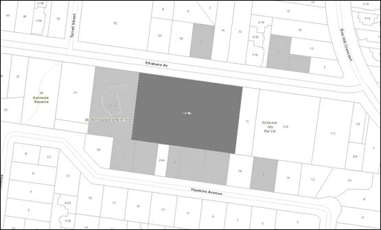
|
|
|
Subject site
|
|
13 Objector Properties for 15
objections
(3 outside of map)
|
é
North
|
BACKGROUND
History
Several Planning Permits were
issued to this site between 1974 and 1982, establishing the use as an aged care
facility.
The Site and Surrounds
The subject site is located on the
south side of Strabane Avenue, 50 metres west of the intersection with Box Hill
Crescent. The site comprises five lots, with a total site frontage of 94.48
metres to the north, with a maximum depth of 60.96 metres and a site area of
5767.5m2. The site has a slope of approximately 7 metres from the
west side of the site down to the east side of the site. A 2.44 metre wide
drainage easement is located along the rear (southern) boundary of all five
lots.
The site currently contains a
predominantly single story brick and concrete building utilised as the
Mecwacare Simon Price Centre Aged Care Facility, which comprises 53 lodging
rooms. The building is sited adjacent to the western boundary with a 20 space
car park located to the east of the site behind a landscaped garden. A
circular driveway traverses the site frontage, served by two crossovers, and an
additional single width vehicle crossover serves a short accessway adjacent to
the western boundary. There is a traffic calming speed hump within Strabane
Avenue to the north of the site. Five Council street trees (Tree 1 to 5) are
located within the road verge.
The arborist report submitted with
the application and prepared by Tree Logic provides an assessment of 46 trees
and 30 of these trees are located on the subject site. A table
summarising the affected trees on the subject site and adjacent lots is
included under the Planning Controls heading below.
The immediately adjacent properties are as follows:
· To
the north across Strabane Avenue there are five detached brick and render
dwellings with a mix of single and double storey forms, hipped and pitched tile
roofs with a consistent front setback of 9-10 metres.
· The
site adjacent to the east is vacant. Planning Permit WH/2014/801 was
issued for construction of three double storey dwellings on this site in 2015.
There are no trees within this site. A site visit has determined construction
has not commenced.
· To
the south there are seven (including two partial) adjacent lots including
detached and semi-detached dwellings abutting the common boundary as follows:
28 Hawkins Avenue
– part abuttal – multi storey brick and render dwelling with north
facing habitable room windows, setback 9.3 metres from the boundary.
26 Hawkins Avenue
– single storey brick dwelling, north facing habitable room windows
setback a minimum of 4.1 metres from the boundary. Trees 34, 35 and 36
are located within this site.
24A Hawkins Avenue
– semi-detached – multi storey brick and render dwelling, north
facing habitable room windows setback 5.29 metres from the common boundary
24 Hawkins Avenue
– semi-detached – multi storey brick and render dwelling, with
north facing habitable room windows setback 5.29 metres from the subject
site. Tree 28 is located within this site.
22 Hawkins Avenue
– multi storey brick and render dwelling, north facing habitable room
windows setback 5.01 metres from the boundary. The arboricultural assessment
identifies Tree 27 within this site
20 Hawkins Avenue
– single storey brick dwelling with a northern façade set back
9.35 metres from the boundary.
18 Hawkins Avenue
– part abuttal – single storey brick dwelling, northern
façade 9.97 metres from the boundary.
· There
are parking restrictions in place on one side of Hawkins Avenue.
· The
adjacent lot to the west accommodates St Joseph’s Hall (which is
protected by Heritage Overlay 263). This is a Council owned community facility
and the U3A is a primary tenant of this building during the week, with other
community groups using the hall on weekends. Trees 37, and 39-43 are
located within this site.
Further to the east, Strabane
Heights Retirement Village at 5-9 Strabane Avenue is a contemporary three
storey building clad with render and brick, and Strabane Gardens Supportive
Care for the Elderly at 1-3 Strabane Avenue is a two storey 1980s era brown
brick building.
Within the wider area, the subject
site is located within a Garden Suburban residential precinct, which supports
predominantly single and double storey detached dwellings, including some
infill medium density development.
The site is located 1.4 kilometres
north-west of Box Hill Train Station, 950 metres north of Tram Route 109 and
1.3 kilometres south of the Eastern Freeway. There are a number of public open
spaces within walking distance of the site, which is 350 metres south east of
Gawler Chain, 165 metres north east of Mont Albert Reserve, 70 metres east of
Ashmole Reserve and 185 metres west of Box Hill Cr Reserve.
Planning Controls
The proposal triggers the need for
a Planning Permit under the following clauses of the Whitehorse Planning
Scheme:
General Residential Zone
Schedule 4
Pursuant to Clause 32.08-8 a permit
is required to construct a building or construct or carry out works for a
residential aged care facility. A development must meet the requirements of
Clause 53.17 Residential Aged Care Facility.
The Garden Area requirement is not
applicable to this development as a Residential Aged Care Facility is not
nested within the Residential Building definition at Clause 73.04-1.
Vegetation Protection Overlay
Schedule 3
In accordance with Clause 42.02-2
of the Vegetation Protection Overlay 3 (VPO3), a
permit is required to remove, destroy or lop vegetation included in
Incorporated Document No. 11 - City
of Whitehorse - Statements of Tree Significance, 2006.
Two trees on the subject site
located adjacent to the northern (front) boundary are protected by the VPO3:
Tree 6 (17 metre high Corymbia citriodora) and Tree 9 (19 metre high Eucalyptus
camaldulensis). Refer to the table below for a summary of tree
impacts.
Significant Landscape Overlay
Schedule 9
Pursuant to Clause 42.03-2 a
Planning Permit is required for the removal or lopping of protected trees
and/or for works within 4 metres of protected trees. The proposed impacts
to protected trees are summarised in the table below:
|
Tree No.
|
Species and
Common Name
|
Height
|
Condition
|
Permit Trigger
|
|
6
|
Corymbia
citriodora
Lemon
Scented Gum
|
17m
|
Mature
tree with fair health and structure
|
VPO3 & SLO9
Crown uplift (lopping) required to clear the proposed
building.
Works within 4m (removal of the existing accessway,
front fence and landscaping)
|
|
8
|
Acacia
Sp
Wattle
|
6m
|
Over
mature tree with fair-poor structure
|
SLO9
Removal
|
|
9
|
Eucalyptus
Camaldulensis
River
Red Gum
|
19m
|
Mature
tree with fair health and structure
|
VPO3 & SLO9
Works
within 4m (removal of existing accessway)
|
|
10
|
Corymbia
citriodora
Lemon
Scented Gum
|
16m
|
Mature
tree with fair health and structure
|
SLO9
Works within 4m (removal of the existing accessway, and
landscaping)
|
|
11
|
Pittosporum
undulatum
Sweet
Pittosporum
|
6m
|
Weed
species
|
SLO9
Removal
|
|
12
|
Melaleuca
styphelioides
Prickly-leaved
Paperbark
|
5m
|
Mature
tree with multiple stems
|
SLO9
Removal
|
|
14
|
Eucalyptus
elata
River
Peppermint
|
8m
|
Multiple
stems and asymmetrical form
|
SLO9
Removal
|
|
15
|
Eucalyptus leucoxylon
'Rosea'
Pink-flowered
Yellow Gum
|
8m
|
Fair
health with a slightly asymmetrical form
|
SLO9
Removal
|
|
16
|
Eucalyptus
elata
River
Peppermint
|
14m
|
Poor
structure, including a cavity at the base of the southern and western leader
branches
|
SLO9
Removal
|
|
17
|
Pittosporum
undulatum
Sweet
Pittosporum
|
6m
|
Weed
species
|
SLO9
Removal
|
|
Tree No.
|
Species and
Common Name
|
Height
|
Condition
|
Permit
Trigger
|
|
18
|
Eucalyptus leucoxylon
'Rosea'
Pink-flowered
Yellow Gum
|
10m
|
Fair-poor
structure. The eastern leader branch has been removed
|
SLO9
Removal
|
|
19
|
Eucalyptus leucoxylon
'Rosea'
Pink-flowered
Yellow Gum
|
10m
|
Mature
tree with fair-poor structure.
|
SLO9
Removal
|
|
20
|
Grevillea
robusta
Silky
Oak
|
12m
|
Mature
tree with fair-poor structure.
|
SLO9
Removal
|
|
22
|
Eucalyptus cladocalyx
'Nana'
Bushy
Sugar Gum
|
8m
|
Basal
wound to the trunk and a fair-poor structure
|
SLO9
Removal
|
|
24
|
Acacia
mearnsii
Late
Black Wattle
|
11m
|
Over-mature
and in decline
|
SLO9
Removal
|
|
25
|
Acacia
mearnsii
Late
Black Wattle
|
10m
|
Fair-poor
structure and galls present throughout the crown
|
SLO9
Removal
|
|
26
|
Corymbia
citriodora
Lemon-scented
Gum
|
16m
|
Moderate
rating. Minor deadwood present
|
SLO9
Works within 4m (pathway and landscaping)
|
|
29
|
Eucalyptus cladocalyx
'Nana'
Bushy
Sugar Gum
|
8m
|
Poor
structure, with a basal cavity
|
SLO9
Removal
|
|
30
|
Melaleuca
linariifolia
Snow in
Summer
|
6m
|
Fair-poor
structure and Moderate rating
|
SLO9
Removal
|
|
31
|
Melaleuca
styphelioides
Prickly-leaved
Paperbark
|
5m
|
Fair-poor
structure
|
SLO9
Removal
|
|
32
|
Melaleuca
linariifolia
Snow in
Summer
|
5m
|
Central
leader branch has been removed
|
SLO9
Removal
|
|
35
|
Pittosporum
undulatum
Sweet
Pittosporum
|
5m
|
Weed
species
|
SLO9
Works
within 4m (pathway)
|
|
38
|
Fraxinus
angustifolia
Narrow-leaved
Ash
|
9m
|
Fair
structure and Moderate rating
|
SLO9
Works
within 4m (pathway and terrace)
|
|
39
|
Corymbia
citriodora
Lemon-scented
Gum
|
12m
|
Mature
tree with fair structure. Included bark in primary union. Moderate
rating.
|
SLO9
Works within 4m (pathway and landscaping)
|
|
Tree No.
|
Species and
Common Name
|
Height
|
Condition
|
Permit
Trigger
|
|
40
|
Eucalyptus leucoxylon
'Rosea'
Pink-flowered
Yellow Gum
|
5m
|
Asymmetric
form with fair-poor structure.
|
SLO9
Works
within 4m (pathway)
|
|
42
|
Callistemon
salignus
Willow
Bottlebrush
|
5m
|
Mature
tree with fair-poor structure
|
SLO9
Works within 4m (pathway and landscaping)
|
|
43
|
Melaleuca
styphelioides
Prickly-leaved
Paperbark
|
6m
|
Semi-mature
tree with fair-poor structure
|
SLO9
Works within 4m (pathway and landscaping)
|
|
44
|
Melaleuca
armillaris
Bracelet
Honey-myrtle
|
5m
|
Fair-poor
structure, with a crown bias to the north-east and a branch tear out at base
|
SLO9
Works within 4m (pathway and landscaping)
|
|
Tree No.
|
Species and
Common
Name
|
Height
|
Condition
|
Permit
Trigger
|
|
45
|
Melaleuca
armillaris
Bracelet
Honey-myrtle
|
5m
|
Sparse
crown
|
SLO9
Removal
|
Historic aerial photography shows
that the subject land was cleared of trees in 1960, and it appears that all of
the trees on site have been planted. As such, Clause 52.17 Native
Vegetation controls do not apply.
PROPOSAL
The application proposes buildings
and works for the staged redevelopment and extension of the existing
residential aged care facility and associated tree removal and lopping.
It is proposed to redevelop the
entire site in stages, to increase the number of beds from 53 to 100 beds,
within a 3-5 storey building. The proposed building is arranged in a
figure-eight shape, containing two internal courtyard gardens at the ground
level. The car parking on site is proposed to increase from 19 to 33 car
spaces.
Demolition of the eastern portion
of the existing facility has already occurred, and works have been undertaken
to shore up the remaining buildings to the west of the site. A Planning
Permit was not required for demolition or excavation, and Council Officers have
confirmed that the works undertaken to date did not require planning approval.
The proposed aged care facility
redevelopment is summarised as follows:
· Lower
Ground Level (partial basement) comprising:
o 33 car spaces comprising
27 visitor spaces in the basement and six staff spaces in a tandem arrangement
at the south-east corner of the lot, all accessed via a new crossover to
Strabane Avenue and a driveway along the east site boundary.
o Access is provided to
the basement via two roller doors, allowing a circular path of travel for waste
and delivery trucks.
o 25,000 litre detention
tank
o Kitchen
o Laundry room
o Waste storage and waste
truck loading area
o Maintenance room
o Bicycle parking for 8
bicycles
o A substation is located
on the site frontage near the north-west corner of the site.
· Ground
Floor:
o Porte cochère to
main entrance doors and lobby, serving a semi-circular accessway utilising two
new vehicle crossovers to Strabane Avenue.
o Reception, staff offices
and meeting room
o 35 lodging rooms with
private balconies
o Resident facilities,
including theatre, gym, café, hairdresser
o Consulting suite
o Lounge
o Internal courtyard
gardens
· First
Floor:
o 43 lodging rooms with
private balconies
o Club lounge
o Lounge
o Dining area
o Private dining room
o Internal gardens
· Second
Floor:
o 22 lodging rooms that
include separate living rooms and private balconies
o Dining area with siting
rooms with internal terraces
o Internal terraces
· Roof
:
o Staff room and lockers
o Storage room
o Services room
o Archive room
· The
front façade of the building is approximately 80 metres long, becoming
higher from west to east relative to the ground. The façade at ground
floor and lower ground floor levels is face brick. The brickwork extends
to the first floor around the windows. The façade at first floor is
predominantly a rendered finish. The top floor is clad with medium grey
Colorbond. Balcony balustrades are either toughened frosted glass or
white render.
· The
maximum height is 15.2 metres above natural ground level at the eastern end,
with the maximum building height towards the western end 10.6 metres, owing to
the slope of the land.
· The
building site coverage is 54.76%.
· 31.3%
of the site will remain permeable.
· 1.5
metre high steel picket front fencing is proposed:
o Around the substation
setback 2.95 metres from the front boundary towards the eastern end of the
frontage, and
o On the front boundary
for a length of 17 metres at the north-west corner of the lot.
· The
trees to be removed are:
o Protected Trees 8, 11,
12, 14-20, 22, 24, 25, 29-32 and 45 (total of 18 trees).
o Trees not protected by
the SLO9 or VPO3: Trees 1 (street tree), 7, 13, 21, 33 and 46 (total of six
trees).
· The
trees on the subject site to be retained are:
o SLO9 protected Trees 6
(VPO3), 9 (VPO3), 10, 23, 26 and 38 (total of six trees).
Construction is proposed in two
stages as follows:
· Stage
1 (east of the existing building) will comprise 85 lodging rooms comprising 45
existing and 40 new lodging rooms comprising:
o Basement – 33 car
spaces; kitchen and laundry
o Ground Floor – 16
lodging rooms
o First Floor – 16
lodging rooms
o Second Floor – 8
lodging rooms
· Stage
2 (west above the existing building) will complete the proposed 100 lodging rooms
including the 40 lodging rooms constructed in Stage 1 and 60 new lodging rooms
comprising:
o Ground Floor – 19
lodging rooms
o First Floor – 27
lodging rooms
o Second Floor – 14
lodging rooms
CONSULTATION
Public Notice
The application was advertised by
mail to the adjacent and nearby property owners and occupiers and by erecting
one large notice to the Strabane Avenue frontage. Following the
advertising period 15 objections (from 13 properties) were received.
The issues raised are summarised as follows:
· Amenity
impacts:
o Overlooking and loss of
privacy from facing windows and decks
o Behaviour of dementia
patients
o Overshadowing of
surrounding residential lots and solar panels on adjacent dwellings
o Loss of views
o Noise from plant
equipment, waste collection, deliveries, visitors, staff and dementia patients
o Light spill from both
internal and security lighting to adjoining residential lots.
o Potential to attract
vermin
· Neighbourhood
Character:
o Building bulk and form
(3-4 storeys high and 75 metres long) is out of keeping with surrounding
residential area.
· Car
parking and traffic:
o Insufficient on-site
parking proposed for staff and visitors
o Traffic and on-street
parking levels on Strabane Avenue are already very high.
o The traffic report does
not provide sufficient parking survey data or include documentation for the
existing or proposed staff numbers, working hours or deliveries
o The accessway for
delivery vehicles is difficult for large trucks to manoeuvre.
· Landscaping:
o Tree removal and loss of
landscape character and habitat.
o Plantings on the
embankment beside U3A are difficult to maintain
· Internal
amenity
o A high number of south
facing resident rooms will not provide any solar access
o West facing rooms and
balconies should be provided with sun protection.
· Discrepancies
on plans:
o Discrepancies between
plans and Waste, Planning and Traffic Reports
· Non-planning
matters:
o Construction worker
parking and noise impacts
o Impact on surrounding
property values
o Increased load on
utilities infrastructure
o Increased runoff to
surrounding residential lots
Consultation Forum
A Consultation Forum was held on 18
February, 2020. Eight objectors, three representatives for the applicant and
the Planning Officer attended the meeting, which was chaired by Councillor
Barker. The Forum included discussion of the objectors’ concerns,
expanding on the objections received. Additional concerns raised by
objectors included:
· Strabane
Gardens to the east is not currently occupied, and will likely contribute to
on-street parking demand in the future.
· One
objector had commissioned shadow diagrams showing the extent of overshadowing
at June 22 (Winter Solstice), and these were displayed at the Forum.
These are discussed further in the Amenity section below. Objectors
considered that the proposed extent of Winter overshadowing is excessive.
· The
proposed Waste Management Plan lists the EPA requirements, rather than
indicating compliance with these guidelines.
· The
objector at No, 20 Hawkins Avenue indicated that solar panels were installed on
this dwelling after the site survey had been undertaken, but prior to the
lodgement of this Planning Permit application, and raised concern with the
overshadowing impacts to these panels.
· A
representative of the U3A indicated a preference for the steep, landscaped
interface between the subject site and St Joseph’s Hall to the west to be
heavily landscaped and fenced for safety and to soften the visual impact of the
proposed built form.
· It
was acknowledged that the on-street parking in the vicinity is in high demand
from St Joseph’s Hall users, and nearby hospital, TAFE, and the subject
site.
· Objectors
were concerned that the submitted Traffic Report does not cover off on delivery
vehicles, waste trucks and ambulances.
· Concern
regarding the location and construction of the proposed rain garden at the
south-east corner of the site, and the potential for flooding of adjoining lots
should the overflow system fail.
The applicant provided the
following advice:
· The
ratio of car spaces to lodging rooms is less for the proposal than the existing
conditions as there are economies of scale associated with increased beds- for
example, additional administration staff may not be required for the extended
facility.
· The
evergreen trees (Banksia marginata) proposed within the landscape strip along
the eastern boundary beside the vehicle accessway are suitable for this
constrained location.
· Residents
at all levels of the proposed building will have access to fresh air without
having to leave the proposed facility, with the use of internal courtyards and
terraces.
· The
building is intended to accommodate a proportion of dementia patients, who will
be accommodated on the lower levels in the first instance. Dementia
patients will be allowed to traverse the continuous internal corridors and
access the internal courtyards/terraces, but will be prevented from wandering
through the use of electronic locking doors. It is anticipated that they
would be barred from external balconies due to the hazard these present.
· Rooms
with kitchenettes and separate living areas at the top floor are anticipated to
accommodate residents who do not suffer from dementia. Married couples
may also be accommodated.
· Paths
around the external perimeter of the building will be used by some patients for
accompanied walks.
· The
applicant (planning consultant) has advised the operator of the existing
facility that the waste collections and deliveries occurring before 6am are in
contravention of EPA requirements and must cease.
· The
applicant acknowledged discrepancies between the submitted plans, Waste
Management Plan and Traffic Report, and confirmed that waste is proposed to be
collected from within the basement at the designated loading bay.
· The
applicant has designed the basement layout to allow waste and delivery vehicles
to travel in a forwards direction throughout, to limit the use of reversing
beepers.
· The
noise of roller doors to basement will adhere to EPA Noise emission
requirements.
· The
architect advised that plant equipment has been centrally located on the roof
and is largely screened by rooms and roof forms to provide additional acoustic
buffering.
· In
response to objectors’ concerns regarding noise emissions from dementia
patients, the applicant advised that the Sustainability Management Plan
requires the utilisation of glazing with acoustic screening properties.
· The
applicant acknowledged that the sewer serving the existing facility is in poor
condition and has failed several times recently. The proposed building
will utilise macerator pumps which will ensure that waste does not block the
sewerage system. A condition will be included to this effect.
· Currently
there are 30 existing residents, who will be accommodated throughout the
construction process.
Referrals
External
Transport for Victoria
The Head, Transport for Victoria
does not object to the proposal.
Internal
Engineering and Environmental
Services Department
· Transport
Engineer
Council’s Transport Engineer
has advised:
· The
parking provision of 33 spaces exceeds the minimum requirement by 3 spaces.
· The
traffic generated by the proposal can be accommodated within the surrounding
road network, including service vehicles.
· The
bicycle space provision is in excess of planning scheme requirements and layout
is satisfactory.
· Sight
lines, head clearance and aisle widths are satisfactory
· Waste
collection not to take place during visiting hours so as to not obstruct
disabled car space.
· Waste
Engineer
The submitted Waste Management Plan
is not satisfactory. The bin storage area requires adequate space for the
storage of bulk and hard waste items. The space required for bulk/hard
waste items can be located in a reconfigured waste bin store or located in a
separately located room/storage area.
· Assets
Engineer
Council’s Assets Engineer has
advised:
· No
trees are permitted to be planted within the easement.
· The
rain garden is not permitted to be constructed within the easement.
· Standard
conditions and notes must be included in the permit
Planning Arborist
Council’s Planning Arborist
has raised concerns regarding potential impacts the demolition works currently
occurring may have on retained trees, and Council’s Planning Enforcement
Officers have raised this with the site operator.
There is no objection to the
proposed removal of Trees 8, 11, 12, 14-20, 22, 24, 25, 29-32 and 45.
Some are weed species and others are poor in health and/or structure.
The proposed buildings and works
encroachments into the TPZs of retained trees on the subject site and adjoining
lots can be supported, subject to tree protection and management condition
requirements.
Parkswide Arborist
Tree 1 is a
semi-mature Quercus coccinea (Scarlet oak) located on the nature strip
outside the subject site. This tree must be removed due to the location of the
proposed crossover. This tree can be removed after the applicant has paid for
the full cost of removal (Amenity Value).
Tree’s 2-5
are all Quercus coccinea (Scarlet oak) of various age and size. The
demolition and development of this site is outside the trees’ TPZ and is
not expected to impact on tree health and longevity.
ESD Advisor
The submitted Sustainability
Management Plan does not meet Council's Environmentally Sustainable Design
standards for a development of this scale, and conditions will require the
submission of an amended and compliant Sustainability Management Plan.
Urban Design
Council’s Urban Designer is
broadly supportive of the proposed built form and layout. Urban Design
comments are included within the discussion below.
Heritage Advisor
Council’s Heritage Advisor
has provided the following comments:
· The
subject site is adjacent to HO263, the former St Joseph’s Chapel at 27
Strabane Avenue, which is also included on the Victorian Heritage Register
(H2351).
· The
provisions of Cl.22.01 of the Whitehorse planning Schemes apply to development
on properties adjacent to properties in a heritage overlay that require a
Planning Permit.
· The
proposed development maintains a similar front setback and side setback at the
western end of the lot as the existing building.
· The
lowest level of the proposed development is to be set at a similar level as the
existing, i.e. well below the ground level of the heritage property at 27
Strabane Avenue. The roof of the 3rd level will be a similar height as the
highest point of the former St Joseph’s Chapel. The significant eucalypt
(Tree 6) in the front setback at the west end of the subject lot is to be
retained, and the existing trees on the eastern boundary of 27 Strabane Ave are
to be protected.
· Notwithstanding
the scale of the new proposal, due to the retention of the existing front and
side setbacks and the height of the proposed building relative to the former St
Joseph’s Chapel, the proposed building will not have a direct impact on
the former St Joseph’s Chapel. The existing views to the entry ramp of
the heritage building will continue to be screened by the existing mature boundary
planting, while the western end of the new building will be sufficiently
removed from the eastern side of the heritage building to retain the existing
open setting of the latter.
· Concerns
were raised however, with the nature and extent of the articulation of the street
elevation relative to the domestic scale and built form of the vernacular
architecture in Strabane Avenue from which the architect Peter Corrigan drew
his design response for St Joseph’s Chapel. While it is not
practical for a building of this scale to respond directly to the local
vernacular, a more respectful response to the streetscape would be desirable,
particularly with respect to its relationship to the former Chapel of St
Joseph.
Health
The size of the kitchen must be
able to accommodate the number of residents. Any noise generated from the
production in the kitchen (such as the canopy exhaust) should be minimal and
not impacting on the neighbouring properties.
Landscape Advisor
Council’s Landscape Advisor
has recommended amendments to the submitted landscape plans, generally to
improve the amenity and safety of outdoor spaces for residents. These
will be discussed further in the Landscaping and Tree Impacts section below
DISCUSSION
Consistency with State and Local
Planning Policies
Clause 21.06 Housing
This clause states that housing in
the City of Whitehorse should provide for a wide range of household types, ages
and cultural groups. The population is slightly older than the metropolitan
average, indicating an ageing population.
Planning Policy for Residential Aged Care
Facilities (Clause 16.01-7S)
The planning policy objective for
residential aged care facilities is ‘to facilitate the development of
well-designed and appropriately located residential aged care
facilities’.
In response to the policy, the
proposal comprises staged development where the east of the building is
proposed to be constructed as Stage 1 and the west of the building is proposed
to be constructed as Stage 2. The purpose of the staging is to enable the
construction of 40 rooms and then for an occupancy permit to be issued for the
new building enabling the residents living in the existing facility to be moved
into the new building prior to construction of Stage 2 in the location of the
existing building.
If Stage 2 is not constructed, the
failure of this construction must not inhibit the function of building
constructed as Stage 1. The assessment conducted in Clause 53.17 considers the
building as a whole; therefore it is important to establish that Stage 1 can
function as its own facility. Stage 1 contains all the facilities which are
vital for the function of the building such as the kitchen, roof plant, lifts,
dining halls and basement car parking. Stage 2 contains facilities which are
non-critical to the function of the building such as meeting rooms, secondary
lounges, recreation and dining spaces, and commercial spaces such as
hairdressers and cafes.
A staged development is necessary
in order to enable existing residents to be accommodated during the
redevelopment, with the submitted staging plan reflecting how this would occur;
but that also the design is functional as in independent facility if, for some
reason, the construction of Stage 2 is delayed.
The General Residential Zone
provisions anticipate different types of residential uses, and the new building
is suitably located in line with the objectives of the planning policy and
particular provisions to integrate aged care in residential areas. Whilst it is
acknowledged that the new facility has a larger form that the adjacent St
Joseph’s Hall and surrounding dwellings, policy at Clause 16.01-7S
indicates, not all appropriate residential uses will have the scale of the
detached dwelling.
The proposed building does not seek
to replicate the existing built form and provides a new and upgraded design
which enhances the facility to be more aesthetically interesting. The
colour palette with natural and pale colours seeks to reduce the visual impact
of the structure as discussed below.
The development provides for a mix
of housing for older people with different levels of mobility and appropriate
access to care and support services by providing both higher care units at the
lower levels and independent living apartments at the second floor with
kitchenettes and private living areas within self-contained units. The
subject site is included in the Principal Public Transport Network and located
in close proximity to the Box Hill Metropolitan Activity Centre and within
walking distance of buses that travel along Elgar Road.
As such, the proposal is considered
to comply with the requirements of Clause 16.01-7S Residential Aged Care
Facilities Policy.
Design and Built Form
Clause 53.17 Residential Aged
Care Facility
Clause 53.17 Residential Aged Care
Facility provisions apply to applications for buildings and works for a
residential aged care facility within the General Residential Zone, and this
Clause prevails over any other provisions in the Planning Scheme which may be
inconsistent. The Development Requirements include a broad range of
design criteria set out in the table below:
Design Criteria
|
Requirement (summary of provisions)
|
Proposal
|
|
Building Height
|
Maximum building height
must not exceed 16 metres
|
Maximum height is 15.2
metres above natural ground level, at the south-east corner of the building.
Complies
|
|
Street Setback
|
The same as the setback
of the front wall on the adjacent lot or 9 metres, whichever is the
lesser.
As St Joseph’s
Hall is set back 12.26 metres from Strabane Avenue, a 9 metre front setback
is required
|
Proposed
front setback is 9 metres.
Complies
|
|
Side and Rear Setbacks
|
Buildings not on the
boundary should be set back from side or rear boundaries by 1 metre,
plus s 0.3 metres for every metre of height over 3.6 metres up to 6.9 metres,
plus 1 metre for every metre of height over 6.9 metres. Some building
elements may encroach into these setbacks.
|
The proposal is
compliant with the side and rear setback requirements with the exception of a
small area of the top corner of the south-east corner where the rear wall is
set back 9.0m from the rear boundary, and rises 14.2m above the proposed
ground level.
The required setback at
this point is 9.29 metres.
Council’s Urban
Designer has provided the adjacent diagram showing the extent of
non-compliance in red. This is a minor incursion, and a condition to
address this issue is not required.
Does not comply
|
|
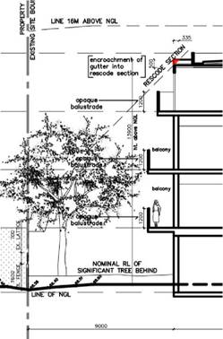
|
|
Walls on Boundaries
|
A new wall constructed
on a side or rear boundary or a carport constructed on or within 1 metre of a
side or rear boundary of lot should not abut the boundary for a length of
more than 10 metres plus 25% of the remaining length of the boundary of an
adjoining lot. This can be extended where there are existing or
simultaneously constructed walls or carports on an abutting lot.
|
There are no walls
proposed on boundaries.
Not applicable
|
|
Daylight to Existing
Windows
|
Buildings opposite an
existing habitable room window should provide for a light court to the
existing window that has a minimum area of 3 square metres and minimum
dimension of 1 metre clear to the sky. The calculation of the area may
include land on the abutting lot.
Walls or carports more
than 3 metres in height opposite an existing habitable room window should be
set back from the window at least 50 per cent of the height of the new wall
if the wall is within a 55 degree arc from the centre of the existing window.
The arc may be swung to within 35 degrees of the plane of the wall containing
the existing window.
Where the existing
window is above ground floor level, the wall height is measured from the
floor level of the room containing the window.
|
The land to the east is vacant and St Joseph’s Hall
to the west is not a residential building.
Therefore this standard pertains to the dwellings to the
south only. The windows of dwellings to the south are all setback over 3.0
metres from the common boundary, therefore this standard is not applicable.
Not applicable
|
|
North-facing Windows
|
If a north-facing
habitable room window of an existing dwelling is within 3 metres of a
boundary on an abutting lot, a building should be setback from the boundary 1
metre, plus 0.6 metres for every metre of height over 3.6 metres up to 6.9
metres, plus 1 metre for every metre of height over 6.9 metres, for a
distance of 3 metres from the edge of each side of the window.
|
The proposed development
complies for all north-facing habitable windows of adjacent dwellings on
Hawkins Avenue, taking into account the varying building heights above NGL
and the varied setbacks of the adjacent dwellings.
Complies
|
|
Over-shadowing Open
Space
|
Where sunlight to the
secluded private open space of an existing dwelling is reduced, at least 75%,
or 40m2 with minimum dimension of 3 metres, whichever is the
lesser area, of the secluded private open space should receive a minimum of
five hours of sunlight between 9 am and 3 pm on 22 September.
If existing sunlight to
the secluded private open space of an existing dwelling is less than the
requirements of this standard, the amount of sunlight should not be further
reduced.
|
Due
to the generous rear setback of 4.7 to 9 metres, the extent of overshadowing
of residential lots to the south is generally contained within the boundary
fence shadows between 9am and 3pm at the Equinox. This will be
discussed further in the amenity section below.
Complies
|
|
Over- shadowing solar
energy systems
|
Buildings should be
sited and designed to ensure that the performance of existing rooftop solar
energy systems on dwellings on adjoining lots in a General Residential Zone,
Neighbourhood Residential Zone or Township Zone are not unreasonably reduced.
The existing rooftop solar energy system must exist at the date the
application is lodged.
|
The objector at 20
Hawkins Avenue has advised that solar panels were installed on this dwelling
prior to the lodgement of this Planning Permit application.
The shadow diagrams for
the Equinox show no overshadowing of the roof of this dwelling between 9am
and 3pm.
The Winter Solstice
shadow diagrams provided by an objector show some shadowing of this dwelling
(at the ground level), but given the height of the solar panels above the ground,
it is anticipated that the solar panels will not be significantly
overshadowed between 9am and 3pm at the Winter Solstice. This is
considered to be satisfactory.
Complies
|
|
Over- looking
|
A habitable room window,
balcony, terrace, deck or patio should be located and designed to avoid
direct views into the secluded private open space of an existing dwelling
within a horizontal distance of 9 metres of the window, balcony, terrace,
deck or patio. Views should be measured within a 45 degree angle from the
plane of the window or perimeter of the balcony, terrace, deck or patio, and
from a height of 1.7 metres above floor level.
A
habitable room window, balcony, terrace, deck or patio with a direct view
into a habitable room window of existing
dwelling within a horizontal distance of 9 metres (measured at ground level)
of the window, balcony, terrace, deck or patio should be either:
· Offset
a minimum of 1.5 metres from the edge of one window to the edge of the other.
· Have
sill heights of at least 1.2 metres above floor level.
· Have
fixed, obscure glazing in any part of the window below 1.2 metres above floor
level.
· Have
permanently fixed external screens to at least 1.2 metres above floor level
and be no more than 25 per cent transparent.
Obscure glazing in any
part of the window below 1.2 metres above floor level may be openable
provided that there are no direct views as specified in this standard.
|
As the east is vacant and the land to the west is not
residential, the overlooking standard is only applicable to the south facing
façade facing to the adjacent Dwellings on Hawkins Avenue.
Council’s Urban Designer has provided diagrams
demonstrating where proposed balconies are within 9 metres of adjacent
secluded private open space areas (See Attachment).
To comply with Cl. 53.17-3, these balconies should be
screened to a minimum of 1.7 m above floor level, or set back at least 9 m
from the rear boundary. (Note that a 1.2 m sill height only applies if the
balcony is within 9m of an existing habitable room window.) A condition
will give effect to this.
Non-compliant, addressed by condition
|
|
Noise Impacts
|
Noise sources, such as
mechanical plant, should not be located near bedrooms of immediately adjacent
existing dwellings.
|
The plant equipment is centrally located on the roof and
will be further screened by the building and roof forms.
Complies
|
|
Daylight to New Windows
|
A window in a habitable
room should be located to face:
· An
outdoor space clear to the sky or a light court with a minimum area of 3
square metres and minimum dimension of 1 metre clear to the sky, not
including land on an abutting lot, or
· A
verandah provided it is open for at least one third of its perimeter, or
· A
carport provided it has two or more open sides and is open for at least one
third of its perimeter.
|
All units have an external interface or an interface to
the internal light court with a minimum area of 3.0 square metres and minimum
dimension of 1.0 metre clear to the sky.
Complies
|
|
Site Coverage
|
The site area covered by
buildings should not exceed 80 percent.
|
The
site coverage proposed is 54.76%.
Complies
|
|
Access
|
Access ways should be
designed to:
· Provide
direct access to on-site designated areas for car and bicycle parking.
· Provide
direct access to the building for emergency vehicles.
· Provide
access for service and delivery vehicles to on-site loading bays and storage
areas.
· Ensure
vehicles can enter and exit a development in a forward direction.
· Provide
a carriageway width of at least 5.5 metres and an internal radius of at least
4 metres at a change of direction.
· The
number and location of access points from streets to the site and the design
of crossovers must be to the requirements of the relevant road authority.
· Shared
access ways or car parks should be located at least 1.5 metres from the
windows of habitable rooms. This setback may be reduced by 1 metre where
there is a fence at least 1.5 metres high or where window sills are at least
1.4 metres above the access way.
|
A minimum 6 metre wide
two-way accessway serving the car park and delivery areas is provided along
the eastern boundary. Vehicles can follow a circular route, so that
reversing movements are minimised and vehicles can enter and exit the site in
a forwards direction.
A semi-circular
accessway serves the porte-cochere. The existing site has three vehicle
crossovers and the proposal also has three crossovers, all of which are to be
relocated. This is appropriate for a site of this scale.
Habitable room windows
and balconies beside the vehicle accessways are located at the upper levels.
Complies
|
|
Building Entry
|
The main pedestrian
entry to a building should:
· Have
convenient access from a street.
· Be
sheltered from the weather.
· Have
convenient access from on-site car parking.
· Have
a designated vehicle standing area suitable for use by a community bus and a
disabled parking area should be provided in an area that is convenient for
the drop-off and pick-up of residents.
|
Pedestrian access to the
front door is provided by the porte-cochere accessway. It is considered
that pedestrians are likely to approach the front door obliquely, and the
driveway provides for this.
While a separate
footpath would offer superior pedestrian access, access via the driveway is
considered acceptable, noting that many visitors will drive to the site and
utilise the lift access from the basement car park.
Complies
|
|
Communal Open Space
|
Accessible and useable
communal open space should be provided for residents and staff.
|
There
are two large internal open space areas with facing terraces at all levels
throughout the building that will be accessible by all residents.
Residents who do not need to be confined (ie do not have dementia) will also
have access to a circulation path around the south and west perimeter of the
building.
The
layout and landscaping of the internal courtyards requires updating to
improve accessibility and amenity, as recommended by Council’s
Landscape Advisor.
Non-compliant, addressed by conditions
|
|
Front Fence
|
A front fence within 3
metres of a street should not exceed:
· 2
metres in height in streets in a Road Category 1; and
· 1.5
metres in height on all other streets.
|
The
frontage is partially fenced to the west of the circular driveway to a height
of 1.5 metres, staggered with the topography of the land.
Council’s
Urban Designer has commented that this fence should either be no higher than
1.2m, or set back behind the north-west corner of the building, to be more in
keeping with the existing and preferred Garden Suburban character of the
area.
Non- compliant, addressed by condition
|
The above table demonstrates that
the development achieves a high level of compliance with Clause 53.17
Residential Aged Care Facilities.
Building Form, Layout and
Presentation
Council’s Urban Designer has
acknowledged that the development is a large building with a correspondingly
large visual bulk. The recessed top level helps to reduce the apparent
bulk, as does the general articulation and the visually lighter top two levels.
The medium grey Colorbond walls on the top level assists with making the upper
level visually recessive and so reduce the apparent bulk.
The building is long compared to
most buildings in the vicinity, and appears very horizontal.
Council’s Urban Designer considers the proposed architectural expression
emphasizes the horizontal, with few elements breaking the continuous
horizontality of the brickwork and the flat roof form, which should be
compensated for by creating vertical elements in the façade and creating
a more varied skyline, using the architectural expression to emphasise these
elements. This will form a condition of approval, and it is considered
that the additional detailing to the façade will address Council’s
Heritage Advisor’s concerns regarding the responsiveness of the design to
the surrounding streetscape.
Council’s Urban Designer has
also expressed concern regarding the balconies at the eastern façade,
which are visually solid, with a rendered finish making them look like cubes
pushed out from the building, presenting as a very prominent visual element on
the east elevation. In response the use of less monolithic and less prominent
balcony details is recommended. This will be achieved by requiring the
balustrade material to be frosted glass, which will be consistent with other
proposed balustrades on the building.
Subject to these conditions,
Council’s Urban Designer considers the visual bulk of the proposed
development is acceptable.
The building is proposed to be clad
with brown face brick, cream render, and grey Colorbond at the upper
level. Brown brick and cream render are materials commonly used in the
area, and Council’s Urban Designer considers the building’s
external materials and colours complement the surrounding buildings and are
acceptable on this site.
The main pedestrian entrance faces
Strabane Avenue and is delineated by a thin canopy above the front door.
The current proposal does not include signage to identify the facility, and
this main entrance is difficult to identify. Council’s Urban
Designer has recommended that the main entrance is more prominently expressed
architecturally. This could be achieved through a thicker
canopy, or making the canopy a different colour, giving it a different shape,
or adding vertical elements such as flagpoles. This will form a condition of
approval.
Clause 22.03 Residential
Development
Despite the development of a large
scale aged care facility being guided primarily by the specific provision in
Clause 53.17, at a more localised level, this clause aims to ensure that any
development is consistent with the envisaged built form, ensure that
development contributes to the preferred neighbourhood character, protects
vegetation, does not detract from the natural environment and ecological
systems, and ensures that development meets the trend of increased
population in the municipality. As such, there is still a need for the
building to acknowledge its location within a residential area. The subject
site is located within the Garden Suburban Precinct 8.
Within this Precinct, the preferred
neighbourhood character is for well-articulated dwellings within open garden
settings incorporating a mix of native and exotic vegetation and large
trees. Front and side boundary setbacks are to be maintained, with new
buildings setback at upper levels to minimise their dominance within the
streetscape. Informal, open streetscapes are to be enhanced by low or open
style front fences.
As noted above, Clause 53.17
overrides other provisions of the Planning Scheme in relation to the built form
elements in the table above and recognises that aged care facilities will have
a different scale and building form to surrounding residential areas. However
consideration of the preferred and prevailing neighbourhood character has been
undertaken by Council’s Urban Designer, who found that the development
does not need to be in keeping with the preferred neighbourhood character in
its scale and built form, but should otherwise be more in keeping with the preferred
character than the current design is. Approaches to achieve this have
been referenced in the above recommended alterations to the building
presentation. Council’s Urban Designer has also recommended the
planting of additional trees, as is the setback of the 1.5 metre high steel
picket fence proposed around the mass plantings at the north-west corner.
Conditions will give effect to these requirements.
Amenity
Overlooking
As per the table above, the
proposed development requires the provision of additional overlooking screening
to a number of balconies on the south elevation at the first and second floor
levels.
Overshadowing
As indicated in the Clause 53.17
assessment table above, the extent of overshadowing of residential lots to the
south is generally contained within the existing boundary fence shadows between
9am and 3pm at the Equinox, and is compliant with the Standard.
The Winter Solstice shadow diagrams
commissioned by one of the objectors and submitted at the Forum indicate a far
greater extent of overshadowing on 21 June, with shadows cast over the secluded
private open space areas of No.s 18-28 Hawkins Avenue at some time between 9am
and 3pm, and No.s 22 and 24 Hawkins Avenue experiencing virtually complete
overshadowing of secluded private open space areas between 9am and 3pm.
It is acknowledged that the Winter
Solstice shadow diagrams indicate considerable impacts to the adjoining lots to
the south of the subject site, however it is important to note that this is one
day of the year, and the worst case scenario, and shadows will reduce
incrementally before and after 21 June each year. The Planning Scheme
utilises the Equinox shadows (21 March/22 September) as an mid-point on the
range of overshadowing that will occur throughout the year, and that shadows at
the Summer Solstice (22 December) will be even less than the Equinox.
In addition, it is noted that there
are a number of existing trees located along the south boundary of the subject
site and nearby on the adjacent residential lots, and these trees (most of
which are evergreen), with heights of 4-16 metres, also contribute to an
existing extent of overshadowing of the adjacent residential lots throughout
the year.
The Purpose of Clause 53.17 is to
ensure residential aged care facilities do not unreasonably impact on the
amenity of adjoining dwellings. This does not preclude any impacts, and
the Standards set out above provide guidance to decision makers regarding
reasonable outcomes.
The significant rear boundary
setbacks of the proposed development ensure that the overshadowing of adjacent
residential lots to the south is negligible at the Equinox, and it is
acknowledged that the objectors’ concerns regarding the Winter Solstice
shadowing are genuine. However the requirements of Clause 53.17
Residential Aged Care Facility do not provide Council with the scope to require
or justify further reductions in a compliant building form in order to mitigate
the extent of overshadowing cast at the Winter Solstice.
Noise
It is noted that objectors stated
at the Forum that proposed Waste Management Plan lists the EPA requirements,
rather than indicating compliance with these guidelines, however review of this
document indicates that Section 3.1 states that Victorian EPA Noise Control
Guidelines will be observed, which is acceptable.
Standard noise conditions will be
included to ensure that plant and equipment such as roller doors comply with
the relevant standards and do not unreasonably impact the amenity of the
surrounding residents. Visitor parking, waste collections and deliveries
are to occur within the basement, which will provide a solid barrier to screen
noise transmission from these activities to surrounding residential lots.
Several objectors have expressed
concern that dementia patients can make quite noisy verbalisations. The
applicant advises that dementia patients will not be allowed outside the
external perimeter of the building unaccompanied. As the use is ‘as
of right’ it is beyond the scope of what can be mandated by permit conditions
to control how patients are managed. Council’s ESD Advisor has
required the Sustainability Management Plan to be updated to provide double
glazing to all external windows, which will provide for acoustic screening of
the interior of the aged care facility.
Landscaping and Tree Impacts
Council’s Planning and
Parkswide Arborists have not objected to the proposed removal of trees, and the
landscape plan shows that new trees and landscaping will be planted around the
perimeter of the building to screen and soften the presentation of the building
form and contribute to the Garden Suburban character of the streetscape.
A condition will be imposed to ensure that service trenches for utilities do
not further impact protected trees. Potential impacts to retained trees
will be managed through tree protection conditions.
Council’s Landscape Advisor has
provided the following comments on the proposed landscape plan:
· Canopy
trees proposed around the perimeter of the site should be positioned, or be
planted with species such that no more than 25% of the mature canopy overhangs
neighbouring lots, to ensure that neighbours do not have an unreasonable
maintenance burden placed upon them.
· The
internal courtyard areas and communal upper level terraces are generously
sized, but do not provide sufficient amenity for future users in their
currently proposed form. The provision of circular walking routes without
steps and more seating/rest points is recommended so that these areas can be
utilised as extensions to adjacent internal communal living areas.
Provision should be made for a diverse range of users and social groups to
utilise these areas, including visitors and solitary residents.
· External
walking paths should also be provided with more seats/rest points.
Seating should be provided with arms to assist residents to lower and raise
themselves.
· Steps
and trip hazards should be removed from courtyards. Where steps are
provided for residents (the proposed “log steppers” and
“balancing log”), these should meet relevant standards for safety.
· Flagstone
pavers proposed would be a trip hazard and a more even paving treatment is
recommended.
The above requirements will be
included as conditions.
As discussed at the Consultation
Forum, the landscape plan proposes the planting of additional trees along the
south boundary, between retained trees, to provide for an upper canopy
landscape screen to soften the building presentation at this interface, however
it is noted that the proposed trees are all to be planted within the existing
2.44 metre wide drainage and sewerage easement that runs along the south
boundary. Therefore, the proposed trees must be relocated clear of this
easement, which may require the realignment of the pedestrian path in order to
achieve a reasonable separation distance between the proposed trees and the
built form.
Car Parking
The proposal has been reviewed by
Council’s Transport Engineers who advised that the provision of 33 car
spaces exceeds the minimum amount required by Clause 52.06 of the Planning
Scheme by three places. It should be noted however that these spaces will
not be available until the completion of Stage One (1), so there will be a
period of time during construction whereby the spaces will not be available for
use by existing residents remaining in the original part of the building.
This is considered to be a temporary situation.
Council’s Transport Engineers
have also advised that anticipated traffic generation, car park and access
layout, and bicycle facilities are satisfactory. Conditions for a Parking
Management Plan are recommended.
Objectors Concerns not
Previously Addressed
· Potential for flooding from the rain garden.
Council’s ESD
Advisor has recommended the rain garden is relocated east of the semi-circular
accessway in order to limit the impacts of any overspill of water from the rain
garden, and this will form a condition of Permit
· Loss
of views.
Views are not protected by the
Planning Scheme.
· Light
spill from both internal and security lighting to adjoining residential lots.
A condition will require a
lighting strategy to be prepared, which will include requirements to limit
light spill to surrounding residential lots.
· Potential
to attract vermin
A condition will be included
requiring the amenity of the area to me maintained, including limiting the
presence of vermin.
· Traffic
and on-street parking levels on Strabane Avenue are already very high.
· The
traffic report does not provide sufficient parking survey data or include
documentation for the existing or proposed staff numbers, working hours or
deliveries
· The
accessway for delivery vehicles is difficult for large trucks to manoeuvre.
The application including the
traffic report has been reviewed by Council’s Transport Engineers who
advise that the application has the required amount of parking, that the local
road network can accommodate the proposed development, and that access aisle
dimensions and turning areas are satisfactory.
· Plantings
on the embankment beside U3A are difficult to maintain.
The maintenance of the subject site
along the west boundary interface will be the responsibility of the applicant,
should a Permit issue. This application cannot address or alter the
circumstances of the adjacent lot.
· A
high number of south facing resident rooms will not provide any solar access.
· West
facing rooms and balconies should be provided with sun protection.
Council’s ESD Advisor has
reviewed the submitted Sustainability Management Plan and required conditions
to achieve a compliant outcome. It is noted that for a development of
this scale, the provision of a proportion of south facing rooms is
inevitable.
· Construction
worker parking and noise impacts.
A Construction Management Plan
will be required to be prepared, should a Permit issue.
· Impact
on surrounding property values
The Victorian Civil
and Administrative Tribunal and its predecessors have generally found
subjective claims that a proposal will reduce property values are difficult, if
not impossible to gauge and of no assistance to the determination of a planning
permit application. It is considered the impacts of a proposal are best
assessed through an assessment of the amenity implications rather than any
impacts upon property values. This report provides a detailed assessment of the
amenity impact of this proposal.
· Increased
load on utilities infrastructure
· Increased
runoff to surrounding residential lots
This application has been assessed
by Council’s Asset Engineers, who have required standard conditions to
manage potential runoff. Should a Permit issue, the Building Permit
process will manage utilities connections and capacity requirements.
CONCLUSION
The proposed extension of the
existing residential aged care facility and associated works is an acceptable
response that satisfies the relevant provisions contained within the Whitehorse
Planning Scheme, including the State and Local Planning Policies, the General
Residential Zone Schedule 4, Significant Landscape Overlay Schedule 9,
Vegetation Protection Overlay Schedule 3 and Clause 53.17 Aged Care
Facilities.
A total of 15 objections were
received as a result of public notice and all of the issues raised have been
discussed as required.
It is considered that the
application should be approved.
Attachment
1 Streetscape
elevations, demolition and staging plan 
2 Plans and
elevations 
3 Equinox Shadow
Diagrams
4 Landscape Plan
5 Overlooking
Diagram 
Council Minutes 25
May 2020
Strategic Planning
9.1.5 Building
Reflectivity: Preliminary Findings
FILE NUMBER: SF19/1729
ATTACHMENT
SUMMARY
Preliminary work has been
carried out to investigate issues around building reflectivity, prompted by
recent developments in Box Hill. The first stage of the study has been
completed and included review of planning controls regulating reflectivity,
local, national and global precedent review, identification of other matters of
a legal or planning nature that should be considered and areas for further
investigation, if desired.
Findings are summarised in this
report and recommendations are provided for how to progress the study.
|
RECOMMENDATION
That Council:
1. Note
the findings of this report.
2. Prepare
a brief to seek information regarding technical engineering advice, including
Environmentally Sustainable Design (ESD) considerations.
3. Refer
funding for this advice to a future budget process.
|
|
CoUNCIL RESOLUTION
Moved by Cr Barker,
Seconded by Cr Davenport
That Council:
1. Note
the findings of this report.
2. Advise
the Department of Environment, Land, Water and Planning (DELWP) of the
preliminary findings about building reflectivity outlined in this report and
recommend investigation of the matter at State level with a view to inclusion
of planning controls to limit building reflectivity in all planning schemes
across Victoria.
3. Prepare
a brief to seek information regarding technical engineering advice, including
Environmentally Sustainable Design (ESD) considerations.
4. Include
funding of $20,000 for this advice in the 2020/2021 budget
Carried
|
background
Investigation into the reflectivity
of high rise buildings is an initiative in the 2019/20 budget. The direction
for this study involves seeking advice to explore existing approaches to
building reflectivity with the view of developing planning mechanisms for Box
Hill. The study seeks legal and planning input in the first instance and stems
from the perspective of visual impact (near and far views) and glare safety
issues. Planology was engaged to carry out the study and produce a report.
The scope of the legal and planning
investigation includes:
· Review
literature in relation to the planning controls regulating the reflectivity of
buildings from both Australian and international jurisdictions;
· Identify
relevant precedents dealing with building reflectivity from the Victorian Civil
and Administrative Tribunal (Tribunal) and Planning Panels Victoria; and
· Identify
any other matters of a legal or planning nature that Council should consider
when contemplating addressing this issue through a planning policy or control.
Outside of the scope of the project
and consultant’s expertise and not forming part of the Planology report
is the technical scientific and engineering aspects of solar glare, including
theoretical modelling and assessment techniques and considerations relating to
environmentally sustainable design including the urban heat island effect.
Preliminary research on these matters has been gathered through existing local
and international examples.
DISCUSSION
The Whitehorse City Council Reflectivity
and Building Design Report November 2019 (the Report) by Planology, at Attachment
1, found that with the increased use of highly reflective materials in the
built environment, there is a growing awareness of the potential for adverse
impacts on motorists, pedestrians, cyclists, train drivers and the occupants of
neighbouring buildings. New buildings with extensive areas of glazing, highly
reflective glass or metal cladding, or areas of sloping glass present the
potential for solar glare and adverse visual impacts.
Despite this potential, there is
surprisingly little guidance regarding building reflectivity and a lack of
accepted criteria from the scientific community defining the acceptable limits.
There are limited examples of guidance in Victorian planning schemes. Planology
considers that the issue needs to be appropriately managed to protect amenity,
maintain a high quality public realm and ensure transport safety. Without good
guidance, opportunities to assess and manage the impact of a building’s
reflectivity often arise only after it has been constructed.
For the purpose of this report, the
term ‘solar glare’ will be used. There are two types of solar
glare, namely:
1. Discomfort
glare, which causes visual discomfort without necessarily affecting the ability
to see; and
2. Disability
glare, which scatters a bright source of light in the eye, impairing the vision
of other objects.
The Report identifies a number of
precedents, namely:
The Melbourne City Council
Reflectivity Study 1987
The topic of disability glare first
gained traction in the 1980’s with the advent of glazed curtain walls
with significant reflectivity. Over time, some local government authorities and
planning bodies have sought to regulate the problem by controlling the use of
building materials based on their reflectivity, namely a reflectivity limit for
façade glazing at 20%.
VCAT Cases
The effect of solar glare from
buildings has not been widely considered or subject to detailed analysis by the
Tribunal. Planology identified and reviewed five key Tribunal decisions canvassing
issues relating to building reflectivity. In summary, the cases demonstrate
that solar glare is a relevant planning consideration that may arise
irrespective of whether the issue is expressly called up as a specific planning
control or policy. Assessing the relative detriment caused by solar glare in a
particular case will be influenced by the relevant planning controls and
policies, the potential impact of the glare, the duration of the solar glare
and its severity.
The issue arose in the five key
cases examined because it had been specifically identified by the relevant
council and ventilated before the Tribunal. In other words, solar glare has
been considered by the Tribunal when councils have been vigilant and attuned to
the issue.
Existing Planning Controls
and Provisions
In Victoria, building reflectivity
has been addressed in planning schemes through the use of the Design and
Development Overlay (DDO).
Amendment C125 to the
Melbourne Planning Scheme
In 2009, the Minister for Planning
appointed the Planning and Advisory Committee (PAC) to consider a proposal at
312-332 St Kilda Road, Southbank. A question considered by the PAC was whether
glare from the proposed building would have an adverse impact on the Shrine of
Remembrance (the Shrine) and activities occurring at the Shrine and environs.
The building façade included a range of glazing types to the tower
portion.
The PAC’s discussion on the
building reflectivity issue is extracted below:
In the knowledge of the PAC, no
Australian standard exists for design guidance or the regulation of reflected
glare from building facades.
The PAC endorses the
recommendation contained in the Facade Reflectivity Report that to reduce the
intensity of sun reflections from the tower in general, glass of a reflectivity
of less than 20% be adopted for use.
In the PAC’s view, the effect
of glare during the ceremonies and services on the Shrine environs is
potentially an unwelcome intrusion.
Amendment C308 to the
Melbourne Planning Scheme
The Panel considering Amendment
C308 to the Melbourne Planning Scheme released its report on 16 May 2019 and
recommended a replacement Schedule to Clause 43.02, Design and Development
Overlay, Schedule 1 (DDO1), consolidating urban design policies and controls to
guide the delivery of a high standard of urban design and architecture in
Central Melbourne. In its report, the Panel supported a design requirement
under the heading Façade Expression and Finishes:
· Facades
should avoid unacceptable glare to the public realm.
Also before the Panel was the draft
Central Melbourne Design Guide November 2018. This document mirrors the
structure of the proposed DDO1 and is intended to support the use and
interpretation of the control. In relation to the design detail, the draft
guide provides the following:
49. Avoid visually exposed
towers with low façade quality.
Avoid façade surfaces
which result in unacceptable levels of glare to the public realm.
Amendment C308 and the Central
Melbourne Design Guide were endorsed by Council on 26 November 2019.
In summary, subject to providing
sufficient strategic justification for controls regulating solar glare,
planning panels have supported such controls in planning schemes. If Council
decides to pursue planning controls or policies to regulate solar glare,
questions will likely arise regarding the adequacy of any technical
justification, the benchmarks that are adopted and the circumstances in which
the controls are intended to apply.
Other Jurisdictions
Australian examples
The New South Wales, State
Environmental Planning Policy No 65 – Design Quality of Residential
Apartment Development incorporates the document titled Apartment Design
Guides 2017 published by the Department of Planning and Environment.
The Apartment Design Guide
contains objective 4 A-3 that “design incorporates shading and glare
control, particularly in warmer months”. The design guidance is as
follows:
A number of the following design
features are used:
· Balconies or sun shading that extend far enough to shade
summer sun, but allow winter sun to penetrate living areas
· Shading devices such as eaves, awnings, balconies,
pergolas, external louvres and planting
· Horizontal shading to north facing windows
· Vertical shading to east and particularly west facing
windows
· Operable shading to allow adjustment and choice
· High performance glass that minimises external glare off
windows, with consideration given to reduce tint glass or glass with a
reflectance level below 20% (reflective films are avoided). [Emphasis
added]
More detailed design and planning
requirements are provided in local councils’ Development Control Plans.
For example, section 3.2.7 of the City of Sydney Development Control Plan 2012
regarding ‘Reflectivity’ provides:
·
Reflective materials used on the
exterior of buildings can result in undesirable glare for pedestrians and on
occupants of other buildings and potentially hazardous glare for motorists.
·
Objectives
a) Minimise
the reflection of sunlight from buildings to surrounding areas and buildings.
b) Ensure
that building materials do not lead to hazardous, undesirable or uncomfortable
glare to pedestrians, motorists or occupants of surrounding buildings.
·
Provisions
1. A
Reflectivity Report that analyses potential solar glare from the proposed
building design may be required for tall buildings.
2. Generally,
light reflectivity from building materials used on facades must not exceed 20%.
International examples
Singapore
In Singapore, the Building and
Construction Authority imposes requirements on control of daylight reflectance
of materials used on the exterior of buildings. The Building Control
Regulations 2003 provide:
Objective
48. The objective of paragraph
49 is to protect occupants of buildings in the vicinity of a building from loss
of amenity caused by the reflection of sunlight off the external surface of
that building, arising from the use of materials with high daylight
reflectance.
Performance requirement
49. The
external surface (including a roof) of a building must be designed and
constructed in a manner such that any reflection of sunlight off the external
surface of the building does not result in loss of amenity to occupants of
other buildings in the vicinity of that building.
44. To comply with this requirement, the
Acceptable Solution contained in the ‘Acceptable Solutions Approved
Document is:
Acceptable Solution
The requirement in paragraph
P.2.1 is deemed to be satisfied if the specifications set out in paragraphs
P.3.2 to P.3.3 are complied with.
P.3.2 The
material used for the building work is deemed acceptable if –
a) The
glass for the building work has a daylight reflectance not exceeding 20% [Emphasis added]
b) Any
material, other than glass, for the building work on -
i. The
façade of the building has a specular reflectance not exceeding 10%
ii. The
roof of the building, inclined at an angle not exceeding 20 degrees from the
horizontal plane, has a specular reflectance not exceeding 10%
iii. The
roof of the building, inclined at an angle more than 20 degrees from the
horizontal plane, has a daylight reflectance not exceeding 20% and a specular
reflectance not exceeding 10%
c) Emulsion
paint on plastered or concrete surfaces has a specular reflectance not
exceeding 10%
London
The City of London ‘Planning
Advice Note – Solar Glare 2017’ and ‘Planning Advice
Note – Solar Convergence 2017’ form part of a series of advice
notes regarding microclimatic issues. These documents provide guidance about
the assessment of solar glare and outline mitigation measures as follows:
46.1 Reducing areas
of glazing and using matt cladding instead;
·
46.2 Reorienting
elements of the building to avoid reflection;
46.3 Replacing areas
of tilted glass by either vertical or nearly horizontal glazing;
46.4 Changing the
glazing or cladding to a less reflective type;
46.5 Using special
low reflectance glass, low reflectance film or fritting (a ceramic coating on
the glass);
46.6 Using
sandblasted or other diffusing glass, for example for balustrades;
46.7 Using external
shading such as louvers or motorised blinds, or vertical fins where the sun
is reflected off a building at a glancing angle;
46.8 Using some form
of opaque screening at street level, though this will usually need to be
large; and
46.9 Planting trees,
although the type of tree will depend on the times of year when glare occurs.
Matters for Considering
Controls
In both Australian and
international jurisdictions, the typical approach is to adopt a benchmark for
building materials’ reflectance properties. The research undertaken as
part of the report indicates that light reflectivity from building material
used on facades must typically not exceed 20%.
However, adopting this measure
alone will not necessarily prevent or mitigate adverse solar glare. A range of
variables will affect the intensity of reflections and their impact, including:
· The
angle of reflection
· The
building’s shape, design and orientation
· The
topography and geographical location
· The
season and time of the day at which the building is observed; and
· The
observers’ tolerance for glare.
The Reflectivity and Building
Design Report concludes that solar glare is an issue requiring careful
attention from concept development to detailed delivery. At design stage, it is
possible to address the potential for solar glare by:
· Building
form and orientation
· Façade
articulation
· Choosing
matt or diffusing materials
· Choosing
low reflectance glazing
Once the building or structure has
been constructed, the issue is naturally more difficult to manage and solutions
are typically limited to retrofitting external shading like louvres or fins or
external blinds to intercept the sunlight and prevent its reflection or
modifying the building material to reduce its reflectivity.
Adopting a control or policy that
will facilitate the assessment of solar glare at the planning stage will assist
project proponents, designers, planners and Council officers alike. Importantly,
it will avoid the need to retrospectively address unforeseen impacts.
If Council wishes to pursue
specific planning controls or policies to regulate solar glare, it is
recommended that Council engages a consultant to provide technical advice supporting
benchmarks and their formulation.
Planology identified the following
matters that will likely influence the development of a planning control:
· Identifying
building designs, orientation and materials that are more likely to cause
potential solar glare issues;
· Developing
and justifying benchmarks against which planning permits applications can be
assessed;
· Ensuring
benchmarks have the sophistication to respond to the various circumstances in
which the proposed control seeks to regulate solar glare, noting the
inadequacies of adopting reflectivity limits alone;
· Exploring
the use of modelling tools;
· Identifying
potential mitigation measures;
· Recognising
the inherent benefits associated with reflective materials in terms of thermal
efficiency and interplay with other planning objectives such as the internal
environmental performance of buildings and the urban heat island effect;
· Balancing
the interplay between solar glare the other planning outcomes sought for an
area; and
· Ascertaining
the characteristics of new buildings that would be captured by the control,
noting that the literature concludes that solar glare is not necessarily a
function of height.
Because Council’s
consideration of these matters will likely be influenced by a range of factors,
an estimate was sought to provide technical information as recommended, noting
there are a limited number of consultants in this field.
The scope of work to provide the
supporting technical information would include:
· Gaining
an understanding of Council’s requirements and constraints with regard to
the reflectivity issue.
· Discussing
the technical aspects of the reflectivity in the built environment.
· Reviewing
Council’s objectives and determine suitable planning conditions related
to reflectivity in the municipality.
· Providing
technical assistance in relation to the reflectivity compliance requirements as
part of the planning requirements,
It is estimated that this technical information would cost
up to $20,000 (excluding GST).
CONSULTATION
As part of scoping the study,
preliminary investigation and informal consultation was carried out to gain an
understanding of the issues, work being done by others in this field and any
other factors impacting building reflectivity. Below is a summary of the
consultation carried out:
City of Melbourne
–Coordinator Green Infrastructure Urban Sustainability
Green Our City Strategic Action
Plan 2017 – 2021 (GOCSAP). This work aims to increase the
understanding of the need and value of green infrastructure to help adapt
Melbourne to the impacts of climate change, specifically around urban heat
reduction (as it relates to building reflectivity) and encouraging buildings
and/or landscape elements that reduce the impact of the urban heat island effect.
City of Melbourne
–Urban Designer
Building reflectivity has been a
consideration for the City of Melbourne in the planning of Fisherman’s
Bend. The issues stem from construction industry trend towards substantial
glass curtain wall buildings, often with heavily tinted and reflective glass to
address solar heat gain. This is compounded by the preference of investors for
curved glass buildings which tend to exaggerate the effects of glare.
City of Whitehorse
–Team Leader Statutory Planning
843 Whitehorse Road Box Hill
Planning Permit, issued 25 November 2019.
Wording around glare was recently
included in permit condition requiring a Façade Strategy to be submitted
and be to the satisfaction of the Responsible Authority. This included the
following wording;
c) External
building materials and finishes not resulting in hazardous or uncomfortable
glare to pedestrians, public transport operators and commuters, motorists,
aircraft, or occupants of surrounding buildings and public spaces to the
satisfaction of the Responsible Authority;
i. Issues
relating to glare and reflectivity of chosen building materials must be
addressed within a report prepared by a suitably qualified engineer to qualify
the outcomes under condition 8(c) of this permit.
City of Whitehorse –ESD
Advisor
Council’s ESD Advisor
outlined that there is no formal path to assess building reflectivity concerns
but rather a range of possibilities that are not fully adequate. A precise
method to demonstrate performance is Daylight Glare modelling which could be
requested as part of a Sustainability Management Plan. It was noted that any
action taken to address building reflectivity issues should be balanced with
ESD considerations like internal environmental performance of buildings and the
urban heat island effect.
FINANCIAL
IMPLICATIONS
Funding included in this year’s budget has been
insufficient to deliver both planning/legal input and engineering advice.
To undertake the latter, additional funds would need to be included in a future
budget.
|
|
Future
estimate
|
Budget
|
Expenditure
|
|
|
|
|
|
|
Budget
19/20 financial year
|
|
10,000
|
6,000
|
|
Additional
engineering advice / future financial year.
|
Up to
20,000
|
|
|
|
|
|
|
|
|
Total
Expenditure
|
|
10,000
|
6,000
|
POLICY IMPLICATIONS
Council Plan
The study of building reflectivity
supports Strategic Direction 2 within the current Council Plan 2017-2021 Year
3. Strategic Direction 2 is to “Maintain and enhance the built
environment to ensure a liveable and sustainable city”
Whitehorse Planning Scheme
The work in the area of building
reflectivity aligns with policy at:
Clause 22.07-3 for the Box Hill
Metropolitan Activity Centre to “encourage use and development that;
promotes sustainable building design and construction and promotes design
excellence.”;
Clause 22.10 Environmentally
Sustainable Design to “encourage innovative technology, design and
processes in all development, which positively influence the sustainability of
buildings”.
The work also aligns with State
Planning Policy in the Whitehorse Planning Scheme at:
Clause 15.01-2S Building Design.
Objective – To achieve
building design outcomes that contribute positively to the local context and
enhance the public realm.
Strategy – Ensure the
form, scale and appearance of development enhances the function and amenity of
the public realm.
Clause 15.02-1S Energy and resource
efficiency
Objective – To encourage
land use and development that is energy and resource efficient, supports a
cooler environment and minimises greenhouse gas emissions.
Strategy – Improve the energy,
water and waste performance of buildings and subdivisions through
environmentally sustainable development.
CONCLUSION
In line with budget provided by
Council around building reflectivity issues, the first stage of investigation
was completed by obtaining legal and planning advice. The Report identifies
that, in Victoria, information around building reflectivity is fragmented and
further steps are required to formalise the information and fill knowledge
gaps. It is recommended that additional funding be referred to a future
budget for technical /engineering advice.
Attachment
1 City of
Whitehorse, Reflectivity and Building Design, November 2019 (Planology)
Council Minutes 25
May 2020
9.1.6 Tree
Assistance Fund Guidelines
FILE NUMBER: SF19/2256
ATTACHMENT
SUMMARY
Establish a
Tree Assistance Fund to support the retention of trees identified by the
Vegetation Protection Overlay (VPO) as significant to our community and support
home owners in the cost of managing these trees. This recognises the
contribution made to the community by large trees and Council’s role in
supporting their care.
|
RECOMMENDATION
That Council:
1. Approves the Whitehorse Tree Assistance Fund
Policy and Guidelines.
2. Continues
to allocate funds for Tree Assistance Fund.
|
|
COUNCIL RESOLUTION
Moved by Cr Davenport,
Seconded by Cr Stennett
That Council:
1. Amend
the Whitehorse Tree Assistance Fund Policy and Guidelines to have two Councillors
on the ‘Decision Panel’.
2. Approves
the Whitehorse Tree Assistance Fund Policy and Guidelines.
3. Continues
to allocate funds for Tree Assistance Fund.
Carried
Unanimously
|
background
At the Special Committee meeting of
Council on 12 November 2018, it was resolved:
That Council:
1. Recognises
that Whitehorse Residents are impacted by the significant tree register;
2. Consider
guidelines for providing grants to owners of properties which have a tree on
the significant tree register to assist with maintenance of those trees;
3. Refer
the matter to the 2019/2020 Budget.
In the 2019-20 Budget, Council
approved $40,000 for the current financial year to assist residents with
maintenance of significant trees, being those trees covered by the Vegetation
Protection Overlay (Schedules 1, 3 and 5) in the Whitehorse Planning Scheme.
Council also approved funding ($14,120 per annum, ongoing) for staff resources
to administer the fund.
DISCUSSION
Whitehorse City Council recognises
the value of our significant trees and in supporting and assisting the
maintenance of significant trees within private gardens. The Tree
Assistance Fund aims to provide funding to support such homeowners access
professional assistance in the care and maintenance of trees listed in the VPO
(Schedules 1, 3 and 5). These trees are generally large in size and make
a contribution to the local neighbourhood.
Council’s Tree Education
Officer, in collaboration with planning staff and Council’s consultant
arborist, has drafted the ‘Whitehorse Tree Assistance Fund –
Policy and Guidelines’ (‘the Guidelines’) (attachment 1)
to administer the funds which cover application requirements, the criteria for
assessment of applications and the process for distribution of funds.
Homeowners whose properties are
covered by the VPO (Schedules 1, 3 and 5) under the Whitehorse Planning Scheme
would be eligible for funding in the form of grants up to $1000.
Funding must be used to support the
health of the individual tree that has triggered the application of a VPO to
that property. Works that would be eligible for the fund include:
· Arborist
assessment to confirm the health status and ULE (useful life expectancy) of the
tree and details management strategies to optimise tree health
· Weight
reduction pruning where limbs are at risk of failure
· Formative
pruning that results in improved aesthetics or health
· Cable
bracing to reduce the risk to property of limb failure
· Removal
of heavy climbing plants that may be damaging the tree
· Treatment
of severe insect pests such as Elm Leaf Beetle where habitat value for native
species is not impacted.
· Treatment
of fungal diseases
· In
the case of dead or dying trees, pruning to form a stable stag tree for habitat
The following projects would not be
eligible:
· Removal
of the tree
· Pruning
for purely aesthetic reasons unless the tree is listed because of its
outstanding aesthetic or unusual form
· Pruning
to accommodate hard surfaces or buildings
· Any
lopping that is not to Australian Standards
The Guidelines propose that funding
allocation would be managed via a similar process to Council’s Heritage
Assistance Fund, whereby landowners are contacted once a year to apply for
funding. Notification of when applications can be made would be advertised each
year through a direct mail-out to those properties covered by a VPO. Generally,
the Fund will be open for applications each August, consideration of
applications would occur during September and October and successful grant
recipients will be notified by early November. Unsuccessful applicants
will be notified at the same time and given a brief explanation as to why
funding was not granted.
A decision panel will be formed by
a mixture of officers, an arborist, a Councillor and a community member. The
Guidelines set out assessment criteria and weighting. Any formal permissions
would be required to be sought prior to seeking funding.
The development of this project also requires the
development of brochures, new web-pages and advertisements.
CONSULTATION
The community consultation
conducted during the period of the Planning Scheme Amendment relating to the
Significant Landscape Overlay, schedule 9 identified the general recognition by
the community that canopy trees are an asset that contributes to the broader
community but that there is a financial cost involved in the management of
particularly older trees.
FINANCIAL
IMPLICATIONS
There has been no current year expenditure of the $40000 grant
money due to the need to thoroughly develop the Guidelines and program in this
current financial year. The Guidelines and a mock panel have reviewed the
Guidelines, assessment criteria and example applications to establish the
program’s correct application, prior to report to Council as per the
original Council Motion. The fund will be ready to commence as per the timing
above in this report, in August 2020.
This year’s financial outlay has been through the use of
existing staff members in the Planning and Building Department with additional
advice from the Department’s consultant arborist.
|
|
Budget
|
Expenditure
|
|
Budget
19/20 financial year
|
$40 000
|
|
|
Development
of guidelines
|
|
$2000
|
|
|
|
|
|
Total
Expenditure
|
|
$2000
|
POLICY IMPLICATIONS
The Council Vision 2013-2023
includes Strategic Direction #3 to protect and enhance our open spaces and
natural environment. The value of the Urban Forest in supporting neighbourhood
character, liveability and resilience is increasingly gaining recognition.
The administration of the Tree
Assistance Fund will follow the example of the Heritage Assistance Fund which
has successfully supported maintenance and improvements to built-form assets
that have been identified as having heritage significance within the
municipality.
The value of large trees extends to
the broader community but as trees age, their maintenance costs increase.
Supporting homeowners to retain trees acknowledges the value they provide to
the neighbourhood.
The tree canopy
cover in Whitehorse is declining with some estimates suggesting a decline at
the rate of 2.5% every 5 years. Tree protection controls in the form of the
VPO are more inclusive than tree protection controls in some of our
neighbouring municipalities, so assistance in tree maintenance will help reduce
any burden to residents. The possibility of financial assistance may also
give residents confidence in choosing larger tree species to plant in their
gardens and thus support the Urban Forest of the future.
Currently there
are approximately 800 properties in Whitehorse that are included in the VPO
(Schedules 1, 3 and 5) with the first study of trees of significance carried
out in 2006 and revisions conducted twice. With grants capped at $1000,
the fund would have capacity to assist 5% of those households each
year.
Limiting the
eligibility for the funding to trees that are listed in the VPO (Schedules 1, 3
and 5) may create demand from residents for an update to the VPO to include
more trees. This would provide greater protection to those trees and
allow an opportunity to celebrate their contribution to the landscape.
Attachment
1 Tree Assistance
Fund General Policy and Guidelines 
Council Minutes 25
May 2020
9.1.7 Box
Hill Metropolitan Activity Centre: Implementing a revised Structure Plan and
Urban Design Framework
ATTACHMENT
SUMMARY
Further work has been undertaken
to progress the longer term strategic vision to 2036 for the Box Hill
Metropolitan Activity Centre (MAC). The project has included community
consultation, analysis of growth and built form and 3D modelling of
development.
The consultant team has prepared
a draft Structure Plan and draft Urban Design Framework for the Box Hill MAC
which includes a revised vision, strategic objectives and built form controls,
plus draft planning provisions.
This report provides a summary
of the draft Structure Plan and draft Urban Design Framework for Box Hill, and
recommends that the draft documents be placed on display for community
comment.
The report also recommends that Council seek authorisation
from the Minister for Planning to prepare an amendment to the Whitehorse
Planning Scheme to implement the project and seek interim planning controls to
be put in place while the planning scheme amendment process for permanent
planning controls is undertaken. It is proposed that the draft documents
and the planning scheme amendment be exhibited concurrently.
|
MOTION
Moved by Cr Liu, Seconded
by Cr Bennett
That Council:
1. Note
the Box Hill Metropolitan Activity Centre draft Structure Plan (Attachment 1)
and draft Urban Design Framework (Attachment 2) for the purpose of community
consultation.
2. Seek
authorisation from the Minister for Planning under the Planning and
Environment Act 1987 (Section 8[a]) to prepare and exhibit an amendment to
the Whitehorse Planning Scheme to implement the recommendations of the
project.
3. Request the Minister for Planning prepare and approve an amendment
to the Whitehorse Planning Scheme under the Planning and Environment Act 1987
(Section 20[4]) to implement the recommendations of the project on an interim
basis until the amendment to implement the recommendations on a permanent
basis has been finalised.
4. Authorise the General Manager City Development to make changes to
the amendment to meet any conditions of authorisation from the Department of
Environment, Land, Water and Planning (DELWP), as well as minor editorial
changes, prior to submitting the amendment to the Minister for Planning for
exhibition.
|
|
Amendment
Moved by Cr Davenport
That Council:
1. Note the Box Hill Metropolitan Activity Centre draft Structure
Plan (Attachment 1) and draft Urban Design Framework (Attachment 2) for the
purpose of community consultation.
2. Seek authorisation
from the Minister for Planning under the Planning and Environment Act 1987 (Section 8[a]) to prepare and
exhibit an amendment to the Whitehorse Planning Scheme to implement the
recommendations of the project.
3. Request the
Minister for Planning prepare and approve an amendment to the Whitehorse
Planning Scheme under the Planning
and Environment Act 1987 (Section 20[4]) to implement the recommendations of the
project on an interim basis until the amendment to implement the
recommendations on a permanent basis has been finalised.
4. Authorise the
General Manager City Development to make changes to the amendment to meet any
conditions of authorisation from the Department of Environment, Land, Water
and Planning (DELWP), as well as minor editorial changes, prior to submitting
the amendment to the Minister for Planning for exhibition.
5. Amend the draft
planning controls in Attachment 3 to:
a) Delete
“Unless otherwise agreed to by the Responsible Authority, the
Affordable Housing dwellings should be Social Housing”.
b) Clarify
that affordable housing includes social housing.
c) Allow
an increase of up to 10% to the preferred building height at sub-clause 4.4-2
in areas where height is 28 m or less, when a building is constructed of
sustainable timber, to recognise that the depth of a timber floor system will
generally be deeper than those required for a concrete floor system.
The Amendment LASPED for want of a
Seconder
|
|
The Motion moved
by Cr Liu, seconded by Cr Bennett was then put and CARRIED UNANIMOUSLY
|
background
In late 2018 Council initiated a
review of the vision and strategic direction for Box Hill. This was intended to
update the existing 2007 Box Hill Transit City Activity Centre Structure Plan
(the 2007 Structure Plan) for the Box Hill Metropolitan Activity Centre (MAC).
The project commenced with the
appointment of MGS Architects and its project team. Appointment of the
consultants followed careful consideration of the findings of the Independent
Panel for Amendment C175 (abandoned by Council on 25 June 2018), discussions
with the State Government, the Victorian Planning Authority and the Box Hill
First Group.
Initial consultation with the
broader community took place in February 2019, concurrent with background
investigation of the MAC by the project team. A Stakeholder Reference Group
(SRG) was formed comprising Government, landowner and community representatives
and met regularly to discuss key issues and workshop concepts relating to the
vision and built form of the MAC. An Analysis and Options Report was
released for a second round of consultation from 15 July until 2 August 2019.
The consultants then prepared a draft Structure Plan and draft Urban Design
Framework (UDF) for Box Hill based on the background work and community
engagement.
The draft documents were peer
reviewed in December 2019. Feedback from the peer review was addressed and the
consultant team has now issued a final draft Structure Plan (Attachment 1) and
draft Urban Design Framework (UDF) (Attachment 2). It is proposed to embed the
documents and their provisions in the Whitehorse Planning Scheme through a
statutory planning scheme amendment process.
DISCUSSION
The draft Box Hill Metropolitan
Activity Centre to 2036 Structure Plan (March 2020) at Attachment 1 is
accompanied by a suite of documents:
· Box
Hill Metropolitan Activity Centre Urban Design Framework (March 2020)
· Box
Hill Metropolitan Activity Centre Analysis and Options Report (April 2020)
· Box
Hill Activity Centre Demand Report (April 2020)
Draft Structure Plan
The draft Structure Plan comprises
a brief overview of the project, community engagement, strategic context,
population projections, employment forecasts and key built form issues. It also
presents a revised vision for Box Hill along with centre-wide and neighbourhood
specific strategic objectives, strategies and actions.
Vision
The Vision for Box Hill was revised
and updated through the background work and community engagement:
“Box Hill is the
pre-eminent urban centre for Melbourne’s east. The centre supports a
regionally significant focus for health, education and employment serviced by a
major public transport hub. It provides a diverse and growing range of business,
retail, entertainment, community and living opportunities.
An interconnected network of
complementary and distinctive, accessible and vibrant neighbourhoods respond to
the diverse community’s desire for sustainable, engaging, safe, caring
and healthy places. Future change in Box Hill will deliver a people-friendly
environment with open and welcoming public spaces for all”.
Strategic Response
The centre-wide objectives,
strategies and actions are grouped into four elements:
· Land
use and development objectives seek to support the continued development of Box
Hill as a regionally significant centre for health, education and employment.
o Objective 1: Develop Box
Hill as the pre-eminent urban centre for Melbourne’s east with a
wide range of uses and activities
o Objective 2: Provide for
future employment growth and rebalance future residential growth in preferred
locations
o Objective 3: Encourage
well-designed medium to high density mixed-use development with a range of
community, employment and accommodation uses that provide diversity of housing
choices and affordable housing
o Objective 4: Support a
regionally significant role as a focus for health, education, employment and
enterprises
o Objective 5: Encourage a
diverse range of retail, entertainment, community and cultural services and
facilities
· Built
form and design objectives seek to ensure that the quality of the public realm
is protected and enhanced by built form responses underpinned by design
excellence.
o Objective 6: Encourage
the development of an interconnected network of distinctive, accessible and
vibrant neighbourhoods and ensure development responds to the defined character
of each neighbourhood
o Objective 7: Protect the
amenity of key public spaces from overshadowing and wind impacts
o Objective 8: Ensure a
high quality interface between buildings and the street at ground and lower
levels, and reduce the impact of vehicle access and loading on footpaths and
the public realm
o Objective 9: Provide for
clear views to the sky from the street
o Objective 10: Relate
building height to the height of neighbouring buildings and site size, and the
preferred character of the precinct
o Objective 11: Ensure
buildings demonstrate high levels of sustainability and architectural merit
· Transport
and movement objectives are underpinned by a hierarchy of transport modes that
ensure the creation of a people-friendly pedestrian environment within a major
mixed used centre and public transport hub.
o Objective 12: Improve
Box Hill’s role and function as a public transport hub of metropolitan
significance
o Objective 13: Prioritise
and encourage walking, bicycle riding and use of public transport, including
interchange between modes
o Objective 14: Allow for
through traffic movement in a manner that is controlled and managed, and ensure
the function of Box Hill as a destination is not adversely impacted by through
traffic
o Objective 15: Encourage
more efficient use of car parking spaces in and around the centre, including
providing for consolidated and publicly accessible parking within buildings
· Public
realm and open space objectives seek to support the delivery of a people
friendly environment with open and welcoming public spaces.
o Objective 16: Deliver
high quality urban spaces that promote social interaction and are engaging,
safe, open and welcoming spaces for all
o Objective 17: Create
streets, laneways and widened footpaths that promote walking and footpath
activity
o Objective 18: Provide
ample, abundant public open spaces for people to gather that are designed for
people first
o Objective 19: Provide
for trees, landscape and greening within the public realm that reflects the
landscape character of each neighbourhood
o Objective 20: Encourage
the incorporation of landscape opportunities within private land that makes a
contribution towards the landscape character of the area
Neighbourhoods of Box Hill
The draft Structure Plan includes a
precinct plan for each of the seven neighbourhoods – Central, Health
& Education, Prospect, Garden, Civic & Cultural, Enterprise, and
Northern and Southern Residential Transition.
Each neighbourhood plan includes a
map and precinct guidelines relating to:
· Built
form and amenity
· Transport
and movement
· Public
realm and open space.
The precinct plans should be read
in conjunction with the UDF.
Implementation
The draft Structure Plan includes
43 implementation actions, which can be grouped under the following different
categories:
· Action
Type
o Deliver (28 actions):
Council delivers projects such as preparation of planning scheme amendments or
public realm upgrades.
o Partner (8 actions):
Council partners with stakeholders, the community and Government to achieve
preferred outcomes and projects.
o Advocate (7 actions):
Council advocates to government agencies and stakeholders to achieve key
outcomes.
· Timeframe
o Immediate: 0-2 years
o Short term: 3-5 years
o Medium term: 6-9 years
o Long term: 10 + years.
Draft Urban Design Framework
The draft UDF provides guidance to
address key issues, implement the neighbourhood visions and recommend a
preferred land use control approach. It responds to the key messages from
community and stakeholder consultation.
The UDF also includes a brief
overview of existing built form controls and issues, and provides the overall
built form and amenity outcomes underpinning the combination of proposed
planning controls (discussed later in this Council report).
The desired built form and amenity outcomes are to be achieved
by requiring development to meet centre wide built form provisions relating to:
|
Built form control
|
Recommendation
|
|
Overshadowing
|
Introduce mandatory overshadowing controls to key public spaces and
streets which determine maximum building heights to ensure that solar access
is maintained across the centre and to the pedestrian network and existing
and future public spaces
|
|
Street wall height and upper level setbacks
|
Introduce maximum street wall heights that relate to the width of
streets and laneways to deliver appropriately scaled public spaces that
encourage pedestrian activity and provides access to sunlight and views of
the sky. Street wall heights will be discretionary but must not exceed a
height to street width ratio of 2:1 in any location. Upper level setbacks
consist of both mandatory minimum and preferred heights.
|
|
Preferred maximum building height
|
Introduce preferred maximum building heights that respond to the
vision and preferred character of each neighbourhood, as well as work
together with the overshadowing controls to protect key public spaces and the
pedestrian network from overshadowing
|
|
Wind effects
|
Introduce wind effects controls to provide clear and measurable
guidelines for comfortable wind conditions for sitting, standing and walking
areas
|
|
Building separation, side and rear setbacks
|
Introduce building separation, and side and rear setback controls to
provide clear views to the sky and ensure sufficient sunlight and privacy to
habitable rooms and private open space
|
|
Street wall setback
|
Define the setbacks at ground level to improve the quality of the
building at the ground level and the amenity of the adjoining public realm,
as well to provide adequate space for planting of street canopy trees in the
public realm
|
|
Active street frontages
|
Provide guidance on the preferred outcomes for active street frontages
and public realm interfaces to provide high levels of interaction between
people in the public realm and adjoining buildings
|
|
Vehicle access, car parking and loading
|
Provide guidance on the design of vehicle access and car parking to
ensure high levels of amenity at the street level and improve the safety of
pedestrians and cyclists
|
|
Building services
|
Provide guidance on the design of building services (such as service
cabinets, waste collection, substations) to assist with the creation of high
quality and safe interfaces between the public realm and buildings at street
level
|
|
Architecture, articulation and materials and finishes
|
Provide guidance on building materials, finishes and articulation to
ensure that buildings contribute positively to their interface with the
public realm, as well as providing durable and sustainable developments
|
|
Landscape contribution
|
Provide guidance on landscape that contributes to increased greenery
and landscape character in the public realm
|
|
Pedestrian links
|
Provide guidance to co-ordinate new pedestrian links with future
development in preferred locations to increase the overall permeability of
the pedestrian network within the activity centre.
|
More specific guidance is provided
in the draft UDF for individual precincts to give effect to the built form
outcomes that are envisioned for each neighbourhood.
The UDF tested the overall planning
outcomes for the MAC based on the proposed vision and land use framework, as
well as estimating yield over the next 20 years. 3D modelling produced an
initial maximum planning envelope for sites across the centre that were derived
from the proposed built form controls, including preferred maximum building
height, street wall height and upper level setbacks, side and rear setbacks,
and overshadowing controls.
The yield of the planning envelope
was then reduced by 50% to provide an estimate for the lower Gross Floor Area
resulting from likely developable floorplates resulting from applying the
proposed controls. This provided an estimated yield of a development envelope.
Further, to determine the
feasibility of the proposed controls, the project team prepared a high level
estimation of indicative yield, which along with the reduction of the planning
envelope assumed that:
· Only
65% of the available development envelope will be developed
· All
developments currently under construction and approved permits will be
constructed
· Buildings
4 storeys and lower were not modelled and instead a general assumption of low
rise developments across the MAC was applied based on analysis of planning
permits.
Between 8,100 and 10,900 additional
jobs are anticipated in the MAC by 2036, and the resident population is
anticipated to grow to between 12, 700 and 14,000 people by 2036. Overall, the
3D modelling and indicative yield estimates strongly suggest that the proposed
built form controls will comfortably accommodate the forecast demand for
additional floor space for residential and employment uses that is required to
accommodate the projected level of growth in Box Hill. The estimates also
suggest that future growth would occupy 74% of available yield if 65% of sites
were developed in accordance with the estimated development envelope.
Proposed planning controls
It is proposed that the Activity
Centre Zone (ACZ) (Attachment 3) is applied to land within the activity centre
boundary to embed the UDF into the Planning Scheme. Planning Practice Note
56: Activity Centre Zones states that the ACZ is the preferred zone for
implementing Structure Plans across Melbourne and allows a tailored suite of
‘Table of uses’ and planning permit requirements. It was developed
specifically for application in activity centres and its purpose is to
encourage a mix of uses, to deliver a diversity of housing at higher densities
and to create an attractive, pleasant, walkable and safe environment. All the
built form and amenity requirements for development expressed in the UDF will
be contained within a schedule to the ACZ, which will require permit
applications to be considered against centre wide built form and amenity
provisions.
The background analysis
demonstrated that there is currently an oversupply of accommodation
(residential) land uses compared to employment uses. If all current permits and
planning applications under consideration were constructed they would deliver
18-20 years’ worth of housing demand but only 4-6 years’ worth of
employment floor space demand. This will result in a lower level of activity
and undermine the preferred neighbourhood character and role of the MAC to
deliver future jobs and economic activity. A key facet of the draft Structure
Plan is setting a maximum allowable percentage of gross floor area (GFA) for
accommodation uses to allow the growth of employment in certain neighbourhoods.
Currently, planning applications strongly favour accommodation (70%) rather
than employment GFA (30%), whereas the Structure Plan is seeking a 50:50
balance overall across the MAC.
The maximum allowable GFA of
accommodation uses for each neighbourhood will be established in the schedule
to the ACZ. The ‘Table of uses’ will allow appropriate uses to be
directed to the preferred neighbourhood/s in the MAC and mean each development
site should provide a contribution towards both employment and residential
demand. The percentages have been tailored to align with the vision statements
for each neighbourhood and vary from 30% in the Health and Education Precinct
to 100% in the Garden Precinct. This means that a development must not provide
more than the maximum residential GFA to allow the prioritisation of employment
floor space that supports the role of the precinct. The variations will
encourage a broader range of non-residential uses to establish in precincts
where employment is the primary function of the Precinct. This means that Box
Hill will continue to develop as a genuine mixed-use centre that remains
regionally significant for health, education and employment.
It is proposed to apply a
Development Plan Overlay (DPO) to the sites known as Box Hill Central (North
and South). The purpose of the DPO is to facilitate the use and development of
the land in accordance with the revised Structure Plan and would contain
requirements unique to these significant redevelopment sites. The DPO would
require the preparation of a development plan prior to the approval of any
planning applications.
It is proposed to delete Clause
22.07 (Box Hill Metropolitan Activity Centre) which outlines the ambitions and
objectives of the current 2007 Structure Plan. The peer review of the revised
Structure Plan concluded that there is no need for a local policy for the MAC
as the relevant provisions can be embedded within the schedule to the ACZ.
Clause 21.07 (Economic Development)
highlights the importance of the Box Hill MAC to the local economy. The
amendment proposes to update this Clause to reference the revised Structure
Plan and UDF. Clause 22.06 (Activity Centres) outlines the hierarchy of
activity centres in the municipality and it is proposed to be updated to
reference the MAC given the deletion of Clause 22.07.
Next steps
A planning scheme amendment is
required to apply the ACZ and embed the Structure Plan and UDF in the
Whitehorse Planning Scheme. Officers have reviewed similar amendments
undertaken by other metropolitan municipalities, as well as discussed different
options available with the Department of Environment, Land, Water and Planning
(DELWP) to help guide development of the planning tools that would be most
appropriate for Box Hill.
It is recommended that consultation
on the draft Structure Plan and UDF be undertaken in parallel with exhibition
of an amendment to the Whitehorse Planning Scheme. This poses a low risk of
“consultation fatigue” to the community, which is also providing
input to related, and concurrent, projects such as the Box Hill Integrated
Transport Strategy. DELWP is also amenable to this approach as it allows for
all potential issues to be thoroughly considered through a “full”
amendment process. This is compared to a “fast track” amendment,
which would have a shorter timeframe, but no opportunity for stakeholder
participation during the statutory process.
It is also recommended that Council
concurrently request interim planning controls in accordance with Section 20(4)
of the Planning and Environment Act 1987 and Planning Practice Note 29:
Ministerial Powers of Intervention in Planning and Heritage Matters. This
has been raised with DELWP who are generally supportive of Council pursuing
interim planning controls. It is expected that the interim planning provisions
contained in the schedule to the ACZ will provide a level of certainty for
landowners and the community about the preferred built form and development in
the MAC while the amendment for the permanent planning provisions is pursued.
The request for interim controls can highlight:
· The
significance of Box Hill in the broader context of Plan Melbourne
· The
extensive consultation undertaken so far for the project
· The
importance of facilitating growth that protects the amenity of the public realm
CONSULTATION
Initial community consultation took
place in February 2019, which included an online survey and publicity on
Council’s web site, Facebook page and in the Whitehorse Leader.
Phase 2 consultation on the Analysis
and Options Report took place from Monday 15 July until Friday 2 August
2019. This included a mail out, information sessions in the Box Hill Mall and
Box Hill Town Hall, a bi-lingual survey in English and Mandarin and publicity
on Council’s website, Facebook page and in the Whitehorse Leader.
Outcomes of this consultation were summarised in a report presented to the
Council meeting on 21 October 2019. The consultation demonstrated broad support
for the vision and distinctive neighbourhoods.
The survey results provided clear
support for a wide range of uses and activities across Box Hill that are
prioritised across the different neighbourhoods. The Phase 2 survey responses
generally reinforced the results from the Phase 1 community consultation.
A Stakeholder Reference Group (SRG)
was formed at the beginning of the project, which comprised State Government,
landowner, community and agency representatives. Ward Councillors and the Mayor
were also part of the group. The SRG had its first meeting on 5 March 2019,
followed by subsequent meetings on 26 March, 30 April 2019, 29 July 2019 and 23
October 2019. Positive feedback was received from the members of the SRG about
the consultation process and the operation of the SRG.
It is proposed that exhibition of
the draft documents and the planning scheme amendment will take place
concurrently once the Minister for Planning has authorised Council to prepare
and exhibit the amendment to the Planning Scheme.
It is noted that the current State of Emergency relating to
the Coronavirus pandemic will alter Council’s normal consultation
process. The community can still engage with Council and provide meaningful
input to a project such as this, however elements of Council’s typical community
engagement process would need to be modified in response to the pandemic.
At the time of this report, the ability to undertake a mail
out to owners and occupiers in the MAC and surrounding area is still available,
however Council has been advised that the Whitehorse Leader has suspended the
publishing of its print and digital editions. Under the Planning and
Environment Act 1987 Council is still required to publish a notice of any
amendment in a newspaper generally circulating in the area to which the
amendment applies.
Online engagement through Council’s website, social
media and OurSay is still available. However it is noted that not all members
of the community have access to information online and/or have the ability to
participate electronically in the statutory amendment process. Additionally,
Council has suspended face to face meetings, such as drop-in sessions.
However, a meeting of the SRG and with other groups could occur via the
internet and phone, were possible, with those that have limited or no access to
the internet.
While hard copies of amendment documents are usually
distributed to Council customer service centres and libraries in Whitehorse
(currently closed), the documents can still be made available on
Council’s website or hard copies mailed on request where the internet is
unavailable.
Notwithstanding the above, the draft documents will become
available for public viewing once minutes of this Council meeting are published
and will allow for review of the documents by interested parties prior to
commencement of any formal amendment process.
It is recommended that Council proceed with the request to
the Minister for Planning to authorise and exhibit the Amendment. Subject to
authorisation of the amendment by the Minister, and any directive issued by the
Minister or DELWP about satisfying the statutory process during the COVID19
pandemic, officers will commence exhibition of the amendment once authorisation
is received.
FINANCIAL
IMPLICATIONS
The project was a major initiative in the 2018/2019 budget
which allocated $375,000 towards the review. In order to undertake additional
consultation on the Analysis and Options Report in July/August 2019, the
project was extended into the 2019/2020 financial year. Council approved an
extension to the project timeframe and additional budget at its meeting on 27
May 2019. $160,550 of the overall project budget was allocated to the
2019/2020 budget year to complete the project. This resulted in a negligible
increase in the overall project expenditure of $550.
Costs associated with the planning
scheme amendment process, such as exhibition costs and statutory fees, are
typically covered by the ongoing operational budget of Council. This includes a
fee to the Minister for Planning to consider a request for interim controls, as
well as a fee to the Minister to consider a request to approve the amendment
for permanent controls.
Charges for the independent panel
vary depending on the duration of the panel hearing and the number of Panel
members appointed. Charges typically cover any travel or accommodation required
by panel members and project support from Planning Panels Victoria. If a
planning panel is required, legal representation and advice would be covered by
Council’s operational budget. If expert witnesses are required these may
require a separate budget allocation.
Refer to the table below for
financial details:
|
Budget
Item
|
Budget
(excl.
GST)
|
Expenditure:
Existing & Future Estimates
(excl. GST)
|
|
1. Consultant
fees - agreed
contract
(2018/2019 and 2019/2020)
|
$375,
550.00
|
$375,
550.00*
|
|
- agreed
variations
(2019/2020)
|
$14,
850.00
|
$14,
850.00*
|
|
2. Study
consultation costs to date
|
$15,000.00
|
$15,000.00*
|
|
3. Future
exhibition costs (operational budget)
|
|
Direct notification
|
|
$14,000.00
|
|
Publicity material and social
media
|
|
$2200.00
|
|
Government Gazette
|
|
$200.00
|
|
4. Future
statutory fees (operational budget)
|
|
Consideration by Minister for a request for interim
controls
|
|
$3,
998.70
|
|
Consideration by the Minister of a request to approve the
amendment
|
|
$481.30
|
|
5. Future
planning panel charges (operational budget)
|
|
Charges
from Planning Panels Victoria, including panel member fees, travel, accommodation
and project support
|
|
$80,000.00
|
|
6. Future
council planning panel representation
|
|
Includes
expert witness, legal representation and advice
|
$50,000.00
|
$50,000.00
|
|
TOTAL
|
$455,400
(Excl operational budget items)
|
$556,280
(Approx. Incl operational budget items)
|
|
* Expended to date
|
POLICY IMPLICATIONS
Plan Melbourne has
designated Box Hill as a Metropolitan Activity Centre and a Health and
Education precinct. The project outcomes therefore seek to ensure Box Hill
continues to perform its role as a significant centre for health, education,
commercial, retail and residential development by providing relevant guidance
and policy for development. The updated draft Structure Plan, draft UDF and
supporting planning controls aim to enhance access to employment closer to
residential areas and combine high frequency multi-modal transport with a range
of major retail, community, government, cultural and civic services to support Plan
Melbourne.
The project sought to review the
vision for Box Hill and update the 2007 Structure Plan to ensure it is relevant
and current. This supports Strategic Direction 2 and Strategic Direction 5
within the current Council Plan 2017-2021. Strategic Direction 2 is to “Maintain
and enhance the built environment to ensure a liveable and sustainable
city” and Strategic Direction 5 is to “Support a healthy
local economy”. The MAC is a regional education, training and health
hub with several large employers. The updated draft Structure Plan and draft
UDF will direct the rebalancing of residential and employment land uses to
support the local and regional economy of Box Hill, while providing for housing
growth.
The project looks to achieve Goal
2.1: “A well connected City with a balanced approach to growth
supported by infrastructure and development that respects our neighbourhood
character” as well as Goal 5.1 which is to “…support a
strong, active local economic environment that attracts investment and provides
economic opportunities for businesses and employment for people”. The
updated draft Structure Plan and draft UDF build on the individual strengths of
economic sectors in Box Hill and supports their future growth and development.
The project outcomes also provide guidance on enriching the public realm and
built environment to ensure that the MAC is accessible, welcoming and
attractive.
Undertaking an Amendment to embed
the draft Structure Plan and draft UDF in the Scheme will result in an updated
and contemporary framework to guide the growth and development of the MAC to
ensure it is an attractive, safe and liveable centre that continues to develop
as the pre-eminent centre in Whitehorse and the eastern metropolitan region of
Melbourne.
Attachment
1 Draft Box Hill
MAC Structure Plan
2 Draft Box Hill
MAC Urban Design Framework
3 Draft Box Hill
MAC Planning Controls
Council Minutes 25
May 2020
9.2 Corporate
9.2.1 Quarterly
Performance Report January to March 2020
FILE NUMBER: 20/72279
ATTACHMENT
SUMMARY
The purpose of this report is to brief
Council on the performance against the Council Plan 2017-2021 and the Annual
Budget 2019/20 for the quarter ended 31 March 2020.
background
Pursuant to
sections 131(3) (a)(ii) and 138 of the Local Government Act 1989, the
Quarterly Performance Report provides a high level summary of Council’s
performance against major initiatives, initiatives, and services identified in
the Annual Plan, which is part of the Adopted Budget 2019/20. These are
significant projects that will directly contribute to the achievement of the Council
Plan 2017-21 and have a major focus on the budget. They may include actions
that are once-off in nature and/or lead to improvements in services.
The financial section of the Quarterly
Performance Report for quarter ended 31 March 2020 has been prepared on an
accruals basis to ensure accurate matching of income and expenditure, both
operating and capital, for the year-to-date ended 31 March 2020. Furthermore,
the financial section is prepared on the basis of year-to-date, year-end
projection, cash and key balance sheet items, and analysing trends against
budget.
DISCUSSION
Performance against Council Plan
The Annual Plan, which is part of the Adopted Budget
2019/20, identifies 29 significant initiatives that contribute to the
achievement of the strategic directions and goals of Council Plan 2017-21.
Of the 29 initiatives being reported on this quarter, three are complete, 21
are on track, and five are behind schedule.
Highlights for the quarter include:
§ Whitehorse
Home and Community Services – Following
the COVID-19 pandemic, the team responded to a significant increase in phone
calls (29%) from consumers requesting information and support. They
further responded to an increase in requests for support from clients for meals
on wheels and support with shopping.
§ Play Space Renewal
Program – Play space upgrades
were completed at Fulton Woorall, Furnes Park, Yaminga, Charlton, Ashmole,
Naughton Patch and Vermont Recreation Reserve (Stage 2).
§ Swimming Pool and
Spa Safety – Building services
team set up and started online
registration of swimming pools and spas in line with the regulatory
requirements for Building Amendment (Swimming Pool) Regulations 2019.
§ Municipal Wide Tree
Study – At its meeting on 16
March 2020, Council resolved to adopt Amendment C219 with minor changes.
Amendment C219 has been sent to the Minister for Planning for approval.
§ Local Government Act
2020 - The Local Government Act
2020 received Royal Assent on 24 March 2020. The Act has a staged implementation
commencing 6 April 2020 through to 1 July 2021.
Performance against Annual Budget
The year to date financial result at 31 March was a surplus
of $54.78m which was $1.99m favourable to budget. This primarily reflects
favourable variances in employee costs ($1.21m) and materials and services
expenditure ($1.98m).
The last review of the year-end result was completed at 31
January and was projected to be a surplus of $24.83m, $265k lower than budget. Given the high level of uncertainty about the impacts
and duration of the pandemic a further forecast review has been deferred with
Council focusing on its response to the coronavirus pandemic, including a range
of community hardship support and stimulus measures to be implemented over the
coming months. A full assessment of the impact will be undertaken prior to
the next quarterly report.
Attachment
1 Quarterly
Performance Report 2019-20 - Quarter 3 January - March 2020
Council Minutes 25
May 2020
9.2.2 Intention
to Lease Land 96-106 Springvale Road, Nunawading
FILE NUMBER: SF08/271
SUMMARY
Council resolved on 16 March 2020 to
commence the statutory procedures under Section 190 and Section 223 of the
Local Government Act 1989 give notice of Council’s intention to grant a
further term of twenty (20) years via a “Deed of Variation” to the
existing thirty (30) year lease for part of the land known as 96-106 Springvale
Road, Nunawading to United Energy Distribution Pty Ltd with a nominal annual
rental of one dollar ($1), if demanded.
A public notice of Council’s
proposal was placed in The Age on Saturday 21 March 2020 and displayed for
twenty eight (28) days on Council’s Website. No submissions were
received.
|
Council
Resolution
Moved by Cr Cutts,
Seconded by Cr Barker
That Council:
1. Having completed the public notice process in
accordance with Sections 190 and 223 of the Local Government Act 1989 and
having received no submissions, resolve to grant a further term of twenty
(20) years via a “Deed of Variation” to the existing thirty (30) year
lease for part of the land known as 96-106 Springvale Road, Nunawading to
United Energy Distribution Pty Ltd with a nominal annual rental of one dollar
($1), if demanded, and with a commencement date of 22 March 2049.
2. Authorise
the Manager of Property & Rates to sign the “Deed of
Variation”.
Carried Unanimously
|
background
Council resolved on 16 March 2020
to commence the statutory procedures under Section 190 and Section 223 of the
Local Government Act 1989 (the Act) to grant a further term of twenty (20)
years via a Deed of Variation to an existing thirty (30) year lease for part of
the Council owned land located at 96-106 Springvale Road, Nunawading to United
Energy Distribution Pty Ltd.
United Energy Distribution Pty Ltd
are the electricity distribution company for Nunawading, they constructed the
substation.
Ownership of the substation remains
with the United Energy Distribution Pty Ltd.
DISCUSSION
As advised in the 16 March 2020 Council
report, Sections 190 and 223 of the Act apply because the further term of
twenty (20) years exceeds the ten (10) year threshold.
It is important to note that
Section 190 and Section 223 of the Act have not been repealed and replaced in
stages #1 or #2 of the Local Government Act 2020 implementation process.
CONSULTATION
On Saturday 21 March 2020, Council
published a public notice in The Age Newspaper advising the Whitehorse
community of Council’s intention to grant a further twenty (20) year
term.
No submissions were received.
Key dates:
· Saturday
21 March 2020: Public
Notice advertisement (In The Age newspaper and
on Council’s website)
· Monday
20 April 2020: Public
submissions close
· Monday
11 May 2020: Special
Committee to hear any submission/s
· Monday
25 May 2020: Report
to Council for consideration
FINANCIAL
IMPLICATIONS
Even though the proposed substation may distribute
electricity supply in the wider Nunawading area, it was constructed at
Council’s request, meaning that Council is the primary beneficiary of the
substation.
Consequently, it is deemed appropriate that the rent payable
under lease, for the duration of the full lease term, including the further
twenty (20) year term, is a nominal rent of one dollar ($1) per annum, if demanded.
All expenses associated with the lease and the statutory
process will be borne by the Property & Rates Department 2019/20 recurrent
budget and these expenses are estimated to be approximately $5,000 + GST.
POLICY IMPLICATIONS
The granting of
this lease is undertaken in accordance with Council’s “Property
Lease and Licence Policy”.
Council Minutes 25
May 2020
9.2.3 Intention
to Lease Land to East Burwood Tennis Club and Mitcham Tennis Club
FILE NUMBER: SF08/271
SUMMARY
Council resolved on 16 March 2020 to
commence the statutory procedures under Section 190 and Section 223 of the
Local Government Act 1989, to give notice of Council’s intention to grant
new leases for the East
Burwood Tennis Club located at 300 Burwood Highway, Burwood East, and Mitcham
Tennis Club located at 68 Dunlavin Road, Nunawading and to authorise the
commencement of the statutory process in accordance with Section 190 of the
Local Government Act 1989.
A public notice of Council’s
proposal was placed in The Age on Saturday 21 March 2020 and displayed for
twenty eight (28) days on Council’s website. No submissions were
received.
|
Council
Resolution
Moved by Cr Stennett,
Seconded by Cr Carr
That Council:
1. Having
completed the public notice process in accordance with Sections 190 and 223
of the Local Government Act 1989 and having received no submissions, resolve
to grant a lease for the Council owned land known as East Burwood Tennis Club
located at 300 Burwood Highway, Burwood East, for
a total lease term of eleven years and four months with no further option
periods, with a proposed commencement date of 1 June 2020.
2. Having
completed the public notice process in accordance with Sections 190 and 223
of the Local Government Act 1989 and having received no submissions, resolve
to grant a lease for the Council owned land known as Mitcham Tennis Club
located at 68 Dunlavin Road, Nunawading, for
a total lease term of eleven years and four months with no further option
periods, with a proposed commencement date of 1 June 2020.
3. Authorise
the Manager of Property & Rates to sign both leases.
Carried Unanimously
|
background
Council has two
tennis club leases, East Burwood Tennis Club and Mitcham Tennis Club, which
have expired and are currently in overholding.
Draft leases were
prepared and provided to both clubs for their review and comment.
DISCUSSION
There are currently ten active
tennis clubs and one combined tennis and bowls club operating on Council land
across the municipality.
East Burwood
Tennis Club and Mitcham Tennis Club are the only two tennis clubs without a
current lease and the proposed leases will align these two clubs with the other
tennis clubs that were granted leases by Council in September 2016.
The proposed and recommended rent
charges are contained within Table #1 below.
Table #1: Proposed and
Recommended Rent Charges:
|
|
East
Burwood Tennis Club
|
Mitcham
Tennis Club
|
|
Year
1*
|
$185
|
$110
|
|
Year
2*
|
$370
|
$220
|
|
Year
3
|
$560
|
$330
|
|
Year
4
|
$580
|
$340
|
|
Year
5
|
$600
|
$350
|
|
Year
6
|
$625
|
$370
|
|
Year
7
|
$650
|
$390
|
|
Year
8
|
$675
|
$410
|
|
Year
9
|
$700
|
$430
|
|
Year
10
|
$725
|
$450
|
|
Year
11
|
$750
|
$500
|
*Year 1 and 2 are phased rates.
CONSULTATION
On Saturday 21 March 2020, Council
published a public notice in The Age Newspaper advising the Whitehorse
community of Council’s intention to grant leases to the two tennis
clubs.
No submissions were received.
Key dates:
· Saturday
21 March 2020: Public
Notice advertisement (In The Age newspaper and
on Council’s website)
· Monday
20 April 2020: Public
submissions close
· Monday
11 May 2020: Special
Committee to hear any submission/s
· Monday
25 May 2020: Report
to Council for consideration
FINANCIAL
IMPLICATIONS
All expenses associated with the lease and the statutory
process will be borne by the Property & Rates Department 2019/20 recurrent
budget and these expenses are estimated to be approximately $5,000 + GST.
POLICY IMPLICATIONS
The granting of this lease is
undertaken in accordance with Council’s “Property Lease and
Licence Policy”.
Council Minutes 25
May 2020
9.2.4 Intention
to Lease Land 653-661 Elgar Road, Mont Albert North
FILE NUMBER: SF08/271
SUMMARY
Council resolved on 16 March 2020 to
commence the statutory procedures under Section 190 and Section 223 of the
Local Government Act 1989 to give notice of Council’s intention to grant
a new lease for a proposed “pole-mounted” substation over part of
the Council owned land known as Elgar Park located at 653-661 Elgar Road, Mont
Albert North and to authorise the commencement of the statutory process in
accordance with Section 190 of the Local Government Act 1989.
A public notice of Council’s
proposal was placed in The Age on Saturday 21 March 2020 and displayed for
twenty eight (28) days on Council’s website. No submissions were
received.
|
Council
Resolution
Moved by Cr Barker,
Seconded by Cr Liu
That Council:
1. Having
completed the public notice process in accordance with Sections 190 and 223
of the Local Government Act 1989 and having received no submissions, grant a
single term fifty (50) year lease for a “pole-mounted” substation
over part of the Council owned land known as 653-661 Elgar Road, Mont Albert
North to United Energy Distribution Pty Ltd with a nominal annual rental of
one dollar ($1), if demanded, and with a likely commencement date of 1 June
2020.
2. Authorise the Manager of Property & Rates to sign the lease.
Carried Unanimously
|
background
Council resolved on 16 March 2020
to commence the statutory procedures under Section 190 and Section 223 of the Local
Government Act 1989 (the Act) to grant a single term fifty (50) year lease
for a “pole-mounted” substation over part of the Council owned land
known as 653-661 Elgar Road, Mont Albert North to United Energy Distribution
Pty Ltd.
United Energy Distribution Pty Ltd
are the electricity distribution company for Mont Albert North.
DISCUSSION
As advised in the 16 March 2020
Council report, Sections 190 and 223 of the Act apply because the lease term of
fifty (50) years exceeds the ten (10) year threshold.
It is important to note that
Section 190 and Section 223 of the Act have not been repealed and replaced in
stages #1 or #2 of the Local Government Act 2020 implementation process.
The location of the substation in
Elgar Park is not impacted by any works associated with the North East Link
Project.
CONSULTATION
On Saturday 21 March 2020, Council
published a public notice in The Age Newspaper advising the Whitehorse
community of Council’s intention to grant a lease with a fifty (50) year
term.
No submissions were received.
Key dates:
· Saturday
21 March 2020: Public
Notice advertisement (In The Age newspaper and
on Council’s website)
· Monday
20 April 2020: Public
submissions close
· Monday
11 May 2020: Special
Committee to hear any submission/s
· Monday
25 May 2020: Report
to Council for consideration
FINANCIAL
IMPLICATIONS
Even though the proposed substation may distribute
electricity supply in the wider Mont Albert North area, it was constructed at
Council’s request, meaning that Council is the primary beneficiary of the
substation.
Consequently, it is deemed appropriate that the rent payable
under lease, for the duration of the full lease term of fifty (50) years, is a
nominal rent of one dollar ($1) per annum, if demanded.
All expenses associated with the lease and the statutory
process will be borne by the Property & Rates Department 2019/20 recurrent
budget and these expenses are estimated to be approximately $7,500 + GST.
POLICY IMPLICATIONS
The granting of this lease is
undertaken in accordance with Council’s “Property Lease and
Licence Policy”.
Council Minutes 25
May 2020
9.2.5 Intention
to Lease Land 379-399 Whitehorse Road, Nunawading
FILE NUMBER: SF08/271
SUMMARY
Council resolved on 16 March 2020 to
commence the statutory procedures under Section 190 and Section 223 of the
Local Government Act 1989, to give notice of Council’s intention to grant
a new lease for a proposed substation over part of the Council owned land
located at 379-399 Whitehorse Road, Nunawading and to authorise the
commencement of the statutory process in accordance with Section 190 of the
Local Government Act 1989.
A public notice of Council’s
proposal was placed in The Age on Saturday 21 March 2020 and displayed for
twenty eight (28) days on Council’s website. No submissions were
received.
|
Council
Resolution
Moved by Cr Stennett,
Seconded by Cr Cutts
That Council:
1. Having
completed the public notice process in accordance with Sections 190 and 223
of the Local Government Act 1989 and having received no submissions, grant a
single term fifty (50) year lease for a substation over part of the Council
owned land known as 379-399 Whitehorse Road, Nunawading to United Energy
Distribution Pty Ltd with a nominal annual rental of one dollar ($1), if
demanded, and with a likely commencement date of 1 June 2020.
2. Authorise the Manager of Property & Rates to sign the lease.
Carried Unanimously
|
background
Council resolved on 16 March 2020
to commence the statutory procedures under Section 190 and Section 223 of the Local
Government Act 1989 (the Act) to grant a single term fifty (50) year lease
for a substation over part of the Council owned land known as 379-399
Whitehorse Road, Nunawading to United Energy Distribution Pty Ltd.
United Energy Distribution Pty Ltd
are the electricity distribution company for Nunawading.
DISCUSSION
As advised in the 16 March 2020
Council report, Sections 190 and 223 of the Act apply because the lease term of
fifty (50) years exceeds the ten (10) year threshold.
It is important to note that
Section 190 and Section 223 of the Act have not been repealed and replaced in
stages #1 or #2 of the Local Government Act 2020 implementation process.
CONSULTATION
On Saturday 21 March 2020, Council
published a public notice in The Age Newspaper advising the Whitehorse
community of Council’s intention to grant a lease with a fifty (50) year
term.
No submissions were received.
Key dates:
· Saturday
21 March 2020: Public
Notice advertisement (In The Age newspaper and
on Council’s website)
· Monday
20 April 2020: Public
submissions close
· Monday
11 May 2020: Special
Committee to hear any submission/s
· Monday
25 May 2020: Report
to Council for consideration
FINANCIAL
IMPLICATIONS
Even though the proposed substation may distribute
electricity supply in the wider Nunawading area, it was constructed at
Council’s request, meaning that Council is the primary beneficiary of the
substation.
Consequently, it is deemed appropriate that the rent payable
under lease, for the duration of the full lease term of fifty (50) years, is a
nominal rent of one dollar ($1) per annum, if demanded.
All expenses associated with the lease and the statutory process
will be borne by the Property & Rates Department 2019/20 recurrent budget
and these expenses are estimated to be approximately $7,500 + GST.
POLICY IMPLICATIONS
The granting of this lease is
undertaken in accordance with Council’s “Property Lease and
Licence Policy”.
Council Minutes 25
May 2020
9.2.6 Electoral
Representation Review –Single Wards/Ward Names
ATTACHMENT
SUMMARY
The purpose of
this report is to respond to the Minister for Local Government’s letter
of 6 May 2020 where he advised Council that Whitehorse will be moving to single
wards, the structure of those wards for the 2020 Council elections and then
inviting Council to name the 11 Wards by the deadline of 25 May 2020.
|
Council
Resolution
Moved by Cr Stennett,
Seconded by Cr Munroe
That Council advise the Minister for Local
Government:
1. That
Council receives and notes the single Ward electoral structure as proposed by
the Minister for the 2020 General Council elections (Attachment 1) and
expresses its disappointment that Council’s and the Victorian Electoral
Commission’s (VEC) multimember option was not endorsed by the Minister.
Furthermore, Council is disappointed with the time constraint imposed by the
Minister which has limited proper and effective community involvement and
consultation for the Minister’s proposed single Ward option and the assigning
of Ward names.
2. That
given the limited time for consideration of Ward names in meeting the
Minister’s deadline of the 25 May, the following are the names proposed
by Council for the respective 11 Wards which are based on The Origin of
Parks’ Names of the City of Whitehorse:
a) Elgar;
b) Cootamundra;
c) Lake;
d) Walker;
e) Kingsley;
f) Sparks;
g) Simpson;
h) Wattle;
i) Eley;
j) Mahoney;
and
k) Terrara
3. That
post the 2020 General Elections Council will seek permission to run a public consultation
process for new Ward names in readiness for the 2024 Council elections.
Carried Unanimously
|
BACKGROUND
The VEC initiated its electoral representation review of
Whitehorse City Council in early July 2019.
Council at its meeting held 15 July, endorsed its
preliminary submission that highlighted a preferred option of 5 wards with 4
wards represented by 2 councillors and 1 ward represented by 3 councillors; and
an alternative option of 4 wards with 3 wards represented by 3 councillors and
1 ward represented by 2 councillors. In addition, three other
non-favoured options were also identified, including an 11 single member ward
option.
In its preliminary report on the
representation review for Whitehorse, the VEC identified that its preferred
option was for 11 Councillors elected from five wards (four two-councillor
wards and one three-councillor ward; and an alternative option of 10
Councillors elected from five two-councillor wards, with adjustments to the current
ward boundaries.
As a result, Council at its
meeting held 16 September 2019, adopted a response submission which fully
supported the VEC’s preferred option of 11 Councillors across 5 wards.
The VEC in its Final Report reiterated this, as its recommended option to the
Minister.
Subsequently, the Minister for
Local Government did not adopt the VEC’s recommendation and with the
passage of the new Local Government Act 2020, has directed a shift to single
member wards. Consequently, in addition to Whitehorse, the
Minister has determined that 7 other metropolitan Councils (Bayside, Cardinia,
Darebin, Greater Dandenong, Kingston, Manningham and Maroondah) would change
from multi-member to single member wards for the 2020 elections.
The Minister wrote to Council on 6 May 2020, inviting it to
provide names for the 11 wards that will apply for the general elections in
October 2020. Council has sought and has been granted a one-day extension
to provide its submission to the Minister by the close of business on Tuesday
26 May, in order that Council can formally consider this matter at its meeting
on Monday 25 May 2020.
DISCUSSION
The Ministerial adopted ward structure
The Minister in his letter (6 May 2020), also enclosed a map
showing the boundaries of the 11 new wards (refer to Attachment 1).
As Council is receiving this information for the first time, officers have
taken the opportunity to provide some general comments on this adopted option
and the 11-ward option included by Council, as part of its preliminary
submission to the VEC’s electoral representation review. Such
observations include:
The respective ward boundaries for both options are
completely different, but generally made good use of main roads.
The adopted option has a strong vertical and north/south
orientation, with all of Middleborough Road and also Blackburn/Surrey Road plus
substantial parts of Elgar and Springvale Road being used as boundaries, whereas
Council’s option has a more local cluster approach;
The Box Hill Activity Centre has not been successfully
captured in one ward, with the majority resting in Ward F;
This VEC model will do for the 2020 elections, however as
you can see with % variations - ward A and ward G are near 5% while ward J is
at 7.75 %. Which of course is the weakness of any single member ward
structure - as in instances of rapid voter population change in one area of the
municipality the boundaries simply do not cope. They will need to be
tweaked for each election. Council previously expressed concerns in its
preliminary submission on single member wards, on the basis of uneven
population growth; the increasing need to constantly monitor for average ward
variances and the inability to properly capture communities of interest eg Box
Hill Activity Centre.
Assigning of ward names
Given the extremely tight time-lines imposed by the Minister
for ward naming suggestions, Council has limited scope to sponsor genuine
community consultation on this issue, including with the indigenous community
and elders. Notwithstanding this difficult situation, officers have
considered that it may be more preferable that Council takes the positive lead
to endorse new ward names, rather than deferring this to a later date, or by
default, allowing the Minister to retain the current alpha reference or
assigning a numeric (1-11) or directional (north, south, central etc) reference
for identification purposes. Clearly, such an outcome would have
undesirable negative community strengthening and recognition impacts, for our
community going forward.
Prior to initiating any action, it is paramount that there
is clarity for all parties, on the basis upon which naming suggestions will be
made. To this end, officers have adopted as the key guiding principle,
that the suggested names should have a high level of relevance and connection
with the ward area and/or the natural features or physical structures within
the ward itself. Importantly, the adoption of such an approach should be
easily understood and embraced by our community. Conversely, an unstructured
approach may invariably engender an undesirable or unwanted outcome that the
community doesn’t understand or support. Accordingly, officers have
reviewed accessible historical data and other information, including assigning
names that the community is readily familiar with, such as the names of
prominent parks or reserves within local communities.
Council may be interested to note that contact was made with
the other 7 metropolitan Councils moving to single member wards, to gauge their
approach to this ward naming request from the Minister. All were
endeavouring to have this matter duly considered by Council, and were utilising
historical, site-specific and other information to arrive at suggested names,
for their respective Council’s consideration.
CONSULTATION
Due to the time constraints for a response to be provided to
by the Minister, no level of community consultation has been possible,
including with the indigenous community and elders. Council officers have
as an urgent measure, sought feedback on possible naming options from our
Historical Societies and other community groups and individuals and are
thankful for their contributions.
Councillors at their informal Assembly of Councillors
meeting Monday 18 May 2020 considered all of the available information and
indicated a preference for the names of prominent parks within the wards as
listed in the recommendation.
FINANCIAL
IMPLICATIONS
There are no financial implications arising from the
preparation of this report.
POLICY IMPLICATIONS
There are no policy implications arising from the
preparation of this report.
Attachment
1 Whitehorse City
Council New Single Ward Boundaries 
Council Minutes 25
May 2020
9.2.7 Delegated
Decisions March 2020
SUMMARY
The following activity was undertaken by officers under
delegated authority during March 2020.
|
DELEGATION
|
FUNCTION
|
Number for March 2019
|
Number for March 2020
|
|
Planning and Environment Act
1987
|
Delegated Decisions
|
127
|
118
|
|
Strategic Planning Decisions
|
Nil
|
Nil
|
|
Telecommunications Act 1997
|
|
Nil
|
Nil
|
|
Subdivision Act 1988
|
|
17
|
5
|
|
Gaming Control Act 1991
|
|
Nil
|
Nil
|
|
Building Act 1993
|
Dispensations & Applications to Building Control
Commission
|
41
|
59
|
|
Liquor Control Reform Act 1998
|
Objections and Prosecutions
|
1
|
Nil
|
|
Food Act 1984
|
Food Act Orders
|
2
|
9
|
|
Public Health & Wellbeing
Act 2008
|
Improvement /
Prohibition Notices
|
2
|
5
|
|
Local Government Act 1989
|
Temporary Rd. Closures
|
10
|
6
|
|
Other Delegations
|
CEO Signed Contracts between $150,000 - $750,000
|
4
|
4
|
|
Property Sales and Leases
|
4
|
23
|
|
Documents to which Council seal affixed
|
1
|
Nil
|
|
Vendor Payments
|
1506
|
1343
|
|
Parking Amendments
|
8
|
4
|
|
Parking Infringements
Withdrawn
|
191
|
242
|
DELEGATED DECISIONS MADE ON PLANNING APPLICATIONS MARCH
2020
All decisions are the subject of conditions which may in
some circumstances alter the use of development approved, or specific grounds
of refusal is an application is not supported.
|
Appl No.
|
Date
|
Decision
|
Street
Address
|
Ward
|
Proposed Use or Development
|
Application
Type
|
|
WH/2017/711/A
|
19.03.20
|
Application Lapsed
|
41-51 Burwood Highway
Burwood Vic 3125
|
Riversdale
|
Amendment to Planning Permit WH/2017/711 to allow changes to the
endorsed plans for additional buildings and works in association with an
existing indoor recreation facility
|
Permit Amendment
|
|
WH/2019/1251
|
11.03.20
|
Application Lapsed
|
7 Marian Court
Blackburn Vic 3130
|
Central
|
Construction of two double storey dwellings and tree removal
|
Multiple Dwellings
|
|
WH/2019/1290
|
11.03.20
|
Application Lapsed
|
56 Philip Street
Vermont Vic 3133
|
Morack
|
Buildings and works (associated with a new dwelling) within 4 metres
of protected trees.
|
Special Landscape Area
|
|
WH/2019/1322
|
02.03.20
|
Application Lapsed
|
84 Windsor Crescent
Surrey Hills Vic 3127
|
Elgar
|
Removal of a Grevillea robusta/Silky Oak tree pursuant to Schedule 9
to the Significant Landscape Overlay
|
VicSmart - Tree
|
|
WH/2019/1336
|
10.03.20
|
Application Lapsed
|
11 Wellington Avenue
Blackburn Vic 3130
|
Central
|
Removal of 12 trees protected SLO2 trees
|
Special Landscape Area
|
|
WH/2020/36
|
20.03.20
|
Application Lapsed
|
21 Richmond Street
Blackburn South Vic 3130
|
Riversdale
|
Two lot Subdivision
|
Subdivision
|
|
WH/2020/54
|
24.03.20
|
Application Lapsed
|
104-168 Hawthorn Road
Forest Hill Vic 3131
|
Morack
|
Construct and Display Signage
|
Advertising Sign
|
|
Appl No.
|
Date
|
Decision
|
Street
Address
|
Ward
|
Proposed Use or Development
|
Application
Type
|
|
WH/2020/76
|
06.03.20
|
Application Lapsed
|
7 Gallus Close Vermont Vic 3133
|
Morack
|
Removal of one (1) SLO9 tree
|
VicSmart - Tree
|
|
WH/2012/511/A
|
17.03.20
|
Delegate Approval - S72 Amendment
|
2/11 Renown Street Burwood Vic 3125
|
Riversdale
|
Amendment to plans under S72 for the removal of Tree 2
|
Permit Amendment
|
|
WH/2014/1235/C
|
20.03.20
|
Delegate Approval - S72 Amendment
|
800 Station Street Box Hill North Vic 3129
|
Elgar
|
Development and use of a Child Care Centre, buildings and works in a
Heritage Overlay, building and works within 4 of a tree and reduction in car
parking requirements
|
Permit Amendment
|
|
WH/2016/489/B
|
31.03.20
|
Delegate Approval - S72 Amendment
|
315 Burwood Highway Burwood East Vic 3151
|
Morack
|
Amendment to plans and permit conditions to Planning Permit
WH/2016/489 for the use of a restricted recreation facility and signage
|
Permit Amendment
|
|
WH/2017/700/A
|
26.03.20
|
Delegate Approval - S72 Amendment
|
14 Parkside Avenue Box Hill Vic 3128
|
Elgar
|
Construction of Two (2) Double Storey Dwellings & Removal of
Vegetation within the Significant Landscape Overlay - Schedule 9
|
Permit Amendment
|
|
WH/2017/924/A
|
02.03.20
|
Delegate Approval - S72 Amendment
|
11 Scott Grove Burwood Vic 3125
|
Riversdale
|
The construction of a double storey dwelling at the rear of the
existing dwelling and vegetation removal
|
Permit Amendment
|
|
WH/2017/929/A
|
23.03.20
|
Delegate Approval - S72 Amendment
|
19 Baratta Street Blackburn South Vic 3130
|
Central
|
Construction of two (2) double storey dwellings
|
Single Dwelling < 300m2
|
|
Appl No.
|
Date
|
Decision
|
Street
Address
|
Ward
|
Proposed Use or Development
|
Application
Type
|
|
WH/2018/21/A
|
06.03.20
|
Delegate Approval - S72 Amendment
|
399 Springfield Road Nunawading Vic 3131
|
Springfield
|
Development of an additional dwelling with garage and carport to
existing residence and tree removal
|
Permit Amendment
|
|
WH/2018/255/A
|
31.03.20
|
Delegate Approval - S72 Amendment
|
2 Elmhurst Road Blackburn Vic 3130
|
Central
|
The construction of two double storey dwellings, buildings and works
within 4 metres of vegetation and vegetation removal.
|
Permit Amendment
|
|
WH/2019/122/A
|
23.03.20
|
Delegate Approval - S72 Amendment
|
14 Fisher Street Forest Hill Vic 3131
|
Springfield
|
Tree removal and buildings and works within 4 metres of protected
trees
|
Permit Amendment
|
|
WH/2016/771/A
|
24.03.20
|
Delegate NOD - S72 Amendment
|
436 Canterbury Road Forest Hill Vic 3131
|
Morack
|
Amendment of plans to planning permit WH/2016/771 to include internal
and external alterations to unit 2
|
Permit Amendment
|
|
WH/2012/440/C
|
11.03.20
|
Delegate NOD Issued
|
193-195 Springvale Road Nunawading Vic 3131
|
Springfield
|
Amendment to plans, permit preamble and conditions of planning permit
WH/2012/440/B (issued for the Construction of a six storey building for a
supermarket, shop, cafe and 86 dwellings, use of the land for sale of liquor,
and reduction in car parking) to include use and development for a place of
assembly deletion of use of a supermarket, deletion of use for sale of liquor
(supermarket), business identification signage and amendments to condition 7
(deletion of condition 7 a, b, c) and deletion of condition 10.
|
Permit Amendment
|
|
Appl No.
|
Date
|
Decision
|
Street
Address
|
Ward
|
Proposed Use or Development
|
Application
Type
|
|
WH/2016/1149/B
|
12.03.20
|
Delegate NOD Issued
|
826-834 Whitehorse Road Box Hill Vic 3128
|
Elgar
|
Buildings and works to construct a building comprising 30 storeys plus
five levels of basement car parking (including dwellings and commercial
uses), use of land for accommodation, and associated reduction of car parking
requirements
|
Permit Amendment
|
|
WH/2018/40
|
05.03.20
|
Delegate NOD Issued
|
10 Court Street Box Hill Vic 3128
|
Elgar
|
Construction of four dwellings and works within 4 metres of SLO9
protected tree
|
Multiple Dwellings
|
|
WH/2018/727
|
11.03.20
|
Delegate NOD Issued
|
55 Boronia Road Vermont Vic 3133
|
Morack
|
Construction of three dwellings, comprising two new double storey
dwellings behind the existing dwelling, associated tree removal and
alteration (intensification) of access to a road in a Road Zone Category 1
|
Multiple Dwellings
|
|
WH/2019/1008
|
18.03.20
|
Delegate NOD Issued
|
4 Aberdeen Road Blackburn South Vic 3130
|
Central
|
Construction of two residential dwellings, removal of vegetation and
buildings and works within 4m of trees
|
Multiple Dwellings
|
|
WH/2019/1132
|
23.03.20
|
Delegate NOD Issued
|
16 Meerut Street Mitcham Vic 3132
|
Springfield
|
Building and works to existing dwelling including proposed alfresco,
garage, pergola and in ground swimming pool
|
Single Dwelling < 300m2
|
|
WH/2019/1173
|
10.03.20
|
Delegate NOD Issued
|
302 Whitehorse Road Nunawading Vic 3131
|
Springfield
|
Use the land for restricted recreation facility (gymnasium) and
display of signs (business identification)
|
Change of Use
|
|
Appl No.
|
Date
|
Decision
|
Street
Address
|
Ward
|
Proposed Use or Development
|
Application
Type
|
|
WH/2019/305
|
17.03.20
|
Delegate NOD Issued
|
209 Canterbury Road Blackburn Vic 3130
|
Central
|
Construction of two double storey dwellings, building and works within
the Special Building Overlay, front fence, tree removal and buildings and
works within the Significant Landscape Overlay Schedule 2 and alteration of access
to a road in a Road Zone Category 1.
|
Multiple Dwellings
|
|
WH/2019/311
|
26.03.20
|
Delegate NOD Issued
|
2a Grove Street Vermont Vic 3133
|
Springfield
|
Buildings and works for the construction of a toilet block and access
ramp, demolition of carport, outbuilding and weatherboard dwelling to create
a new driveway, alteration of access to a road zone (RDZ1) including
associated vegetation removal and buildings and works within 4 metres of
protected trees
|
Other
|
|
WH/2019/39
|
17.03.20
|
Delegate NOD Issued
|
730 Canterbury Road Surrey Hills Vic 3127
|
Riversdale
|
Buildings and Works (in association with use of land for the purpose
of a Telecommunications Facility) and Vegetation Removal/Lopping
|
Telecommunications
|
|
WH/2019/508
|
19.03.20
|
Delegate NOD Issued
|
17 Douglas Street Blackburn North Vic 3130
|
Central
|
The development of the land for two (2) double storey dwellings,
removal of a tree and buildings and works within 4 metres of protected trees
|
Multiple Dwellings
|
|
Appl No.
|
Date
|
Decision
|
Street
Address
|
Ward
|
Proposed Use or Development
|
Application
Type
|
|
WH/2019/511
|
26.03.20
|
Delegate NOD Issued
|
6 Centre Road Vermont Vic 3133
|
Morack
|
Construction of two double storey dwellings, tree removal and
buildings and works within four metres of protected trees.
|
Multiple Dwellings
|
|
WH/2019/526
|
31.03.20
|
Delegate NOD Issued
|
21 Ellingworth Parade Box Hill Vic 3128
|
Elgar
|
Buildings and works for the Construction of an eight storey office
tower, basement, and reduction of the car parking rate
|
Business
|
|
WH/2019/539
|
17.03.20
|
Delegate NOD Issued
|
8 Flora Grove Forest Hill Vic 3131
|
Central
|
Construction of two single storey dwellings within the Significant
Landscape Overlay Schedule 9
|
Multiple Dwellings
|
|
WH/2019/725
|
25.03.20
|
Delegate NOD Issued
|
179 Mahoneys Road Forest Hill Vic 3131
|
Morack
|
Use and development for the purpose of a childcare centre, display of
internally illuminated business identification signage, associated tree
removal and buildings and works within 4 metres of protected trees, generally
in accordance with the endorsed plans and subject to the following
conditions.
|
Child Care Centre
|
|
WH/2019/791
|
23.03.20
|
Delegate NOD Issued
|
13 Rosalind Crescent Blackburn Vic 3130
|
Central
|
Construction of a two storey dwelling on a lot including tree removal,
buildings and works and construction of a front fence within the Significant
Landscape Overlay Schedule 2
|
Single Dwelling < 300m2
|
|
WH/2018/621
|
27.03.20
|
Delegate Permit Issued
|
22 Howard Street Box Hill Vic 3128
|
Elgar
|
Construction of Three (3) Dwellings on a Lot and Removal of Vegetation
|
Multiple Dwellings
|
|
Appl No.
|
Date
|
Decision
|
Street
Address
|
Ward
|
Proposed Use or Development
|
Application
Type
|
|
WH/2019/1021
|
17.03.20
|
Delegate Permit Issued
|
2 Cameron Road Box Hill North Vic 3129
|
Elgar
|
Buildings and works within 4 metres of protected trees and tree
removal
|
Special Landscape Area
|
|
WH/2019/1072
|
11.03.20
|
Delegate Permit Issued
|
78 Middleborough Road Burwood East Vic 3151
|
Riversdale
|
Creation of a Reserve and Easement
|
Subdivision
|
|
WH/2019/1087
|
02.03.20
|
Delegate Permit Issued
|
1 Wilton Street Blackburn North Vic 3130
|
Central
|
Buildings and works within 4 metres of protected trees
|
Special Landscape Area
|
|
WH/2019/1177
|
17.03.20
|
Delegate Permit Issued
|
44 Williams Road Blackburn Vic 3130
|
Central
|
Works associated with a widened vehicle crossover within 4 metres of a
protected street tree.
|
Special Landscape Area
|
|
WH/2019/1220
|
23.03.20
|
Delegate Permit Issued
|
820-824 Whitehorse Road Box Hill Vic 3128
|
Elgar
|
Subdivision of building in accordance with the Section 32A provisions
, Variation of Easement E-1 and Removal of Easement E-2, both on PS 418535
|
Subdivision
|
|
WH/2019/1232
|
23.03.20
|
Delegate Permit Issued
|
31 Beaver Street Box Hill South Vic 3128
|
Riversdale
|
The development of the land for two double storey dwellings, buildings
and works within 4 metres of protected vegetation and the removal of
vegetation
|
Multiple Dwellings
|
|
WH/2019/1253
|
24.03.20
|
Delegate Permit Issued
|
21 Wattle Valley Road Mitcham Vic 3132
|
Springfield
|
Buildings and works for the development of a park including removal of
vegetation and construction of gravel path within 4m of trees protected under
SLO9
|
Special Landscape Area
|
|
Appl No.
|
Date
|
Decision
|
Street
Address
|
Ward
|
Proposed Use or Development
|
Application
Type
|
|
WH/2019/1284
|
10.03.20
|
Delegate Permit Issued
|
Vodafone 636 Burwood Highway Vermont South Vic 3133
|
Morack
|
Works (path, bridge and retaining walls) associated with construction
of a shared use path for informal outdoor recreation (shared bicycle and
pedestrian path)
|
Public Open Space
|
|
WH/2019/1299
|
31.03.20
|
Delegate Permit Issued
|
16 David Street Box Hill South Vic 3128
|
Riversdale
|
Buildings and works associated with a new dwelling within 4 metres of
a protected tree.
|
Single Dwelling < 300m2
|
|
WH/2019/1302
|
06.03.20
|
Delegate Permit Issued
|
38 Gillard Street Burwood Vic 3125
|
Riversdale
|
Two lot subdivision
|
Subdivision
|
|
WH/2019/1320
|
23.03.20
|
Delegate Permit Issued
|
77 Laburnum Street Blackburn Vic 3130
|
Central
|
Three lot subdivision
|
Subdivision
|
|
WH/2019/1325
|
26.03.20
|
Delegate Permit Issued
|
27 Doncaster East Road Mitcham Vic 3132
|
Springfield
|
alterations and additions to the existing hospital building, removal
of protected trees and buildings and works within 4 metres of protected trees
|
Residential (Other)
|
|
WH/2019/553
|
24.03.20
|
Delegate Permit Issued
|
19 Christine Street Blackburn South Vic 3130
|
Central
|
Construction of two dwellings and Buildings and works within a Special
Building Overlay(SBO)
|
Multiple Dwellings
|
|
WH/2019/689
|
23.03.20
|
Delegate Permit Issued
|
6 Ryan Grove Blackburn South Vic 3130
|
Central
|
Construction of second (double storey) dwelling and buildings and
works within 4m of protected trees
|
Multiple Dwellings
|
|
Appl No.
|
Date
|
Decision
|
Street
Address
|
Ward
|
Proposed Use or Development
|
Application
Type
|
|
WH/2019/690
|
05.03.20
|
Delegate Permit Issued
|
1/811 Whitehorse Road Mont Albert Vic 3127
|
Elgar
|
Use of the land for accommodation, buildings and works for the
construction of a mixed use tower building, basement, reduction of the car
parking requirements, and variation of access road within a Road Zone
Category 1
|
Business
|
|
WH/2019/768
|
10.03.20
|
Delegate Permit Issued
|
56 Eley Road Burwood East Vic 3151
|
Riversdale
|
2 lot subdivision
|
Subdivision
|
|
WH/2019/811
|
03.03.20
|
Delegate Permit Issued
|
Lg 1/21 Queen Street Blackburn Vic 3130
|
Central
|
Construct and display internally illuminated business identification
signage
|
Advertising Sign
|
|
WH/2019/875
|
30.03.20
|
Delegate Permit Issued
|
11 Mccomas Grove Burwood VIC 3125
|
Riversdale
|
Construction of Two (2) Double Storey Dwellings
|
Multiple Dwellings
|
|
WH/2020/1
|
05.03.20
|
Delegate Permit Issued
|
7 Bedford Street Box Hill Vic 3128
|
Elgar
|
Removal of vegetation and buildings and works within 4 metres of
protected vegetation within SLO9
|
Special Landscape Area
|
|
WH/2020/108
|
23.03.20
|
Delegate Permit Issued
|
24 Central Avenue Burwood Vic 3125
|
Riversdale
|
Subdivision into two lots
|
Subdivision
|
|
WH/2020/113
|
16.03.20
|
Delegate Permit Issued
|
1/1035 Riversdale Road Surrey Hills Vic 3127
|
Riversdale
|
To re-subdivide Lots 1, 2,3 and Common Property on SP23483U and Lot 1
on TP842411T to create Lots 1, 2,3 and Common Property No.1
|
Subdivision
|
|
WH/2020/118
|
02.03.20
|
Delegate Permit Issued
|
11 Huskey Court Vermont South Vic 3133
|
Morack
|
Removal of one protected tree in the Significant Landscape Overlay
Schedule 9
|
VicSmart - Tree
|
|
Appl No.
|
Date
|
Decision
|
Street
Address
|
Ward
|
Proposed Use or Development
|
Application
Type
|
|
WH/2020/141
|
06.03.20
|
Delegate Permit Issued
|
46 Menin Road Forest Hill Vic 3131
|
Springfield
|
Removal of 1 tree
|
VicSmart - Tree
|
|
WH/2020/143
|
04.03.20
|
Delegate Permit Issued
|
97 Nelson Road Box Hill North Vic 3129
|
Elgar
|
Three (3) lot subdivision
|
Subdivision
|
|
WH/2020/150
|
02.03.20
|
Delegate Permit Issued
|
45 Meldan Street Burwood Vic 3125
|
Riversdale
|
Removal of one tree protected under the Significant Landscape Overlay
Schedule 9
|
VicSmart - Tree
|
|
WH/2020/152
|
12.03.20
|
Delegate Permit Issued
|
2/315 Mont Albert Road Mont Albert Vic 3127
|
Elgar
|
Buildings and works in an Overlay (veranda).
|
VicSmart - General Application
|
|
WH/2020/165
|
27.03.20
|
Delegate Permit Issued
|
2a Norvel Street Blackburn Vic 3130
|
Central
|
Construction of a front fence including associated buildings and works
within 4 metres of protected SLO9 tree
|
VicSmart - General Application
|
|
WH/2020/166
|
12.03.20
|
Delegate Permit Issued
|
38 Marama Street Blackburn South Vic 3130
|
Central
|
Buildings and works on lot under 500m2 (front fence)
|
VicSmart - General Application
|
|
WH/2020/168
|
16.03.20
|
Delegate Permit Issued
|
28 Margaret Street Box Hill Vic 3128
|
Elgar
|
Three lot subdivision
|
Subdivision
|
|
WH/2020/169
|
20.03.20
|
Delegate Permit Issued
|
51 Glen Ebor Avenue Blackburn Vic 3130
|
Central
|
Removal of one tree
|
VicSmart - Tree
|
|
WH/2020/170
|
17.03.20
|
Delegate Permit Issued
|
47 Romoly Drive Forest Hill Vic 3131
|
Central
|
Subdivision of land into 2 lots
|
Subdivision
|
|
WH/2020/175
|
05.03.20
|
Delegate Permit Issued
|
9 Monash Street Box Hill South Vic 3128
|
Riversdale
|
Removal of a Liquidambar styraciflua (Sweet Gum) tree pursuant to
Schedule 9 to the Significant Landscape Overlay
|
VicSmart - Tree
|
|
Appl No.
|
Date
|
Decision
|
Street
Address
|
Ward
|
Proposed Use or Development
|
Application
Type
|
|
WH/2020/176
|
13.03.20
|
Delegate Permit Issued
|
70 Baratta Street Blackburn South Vic 3130
|
Central
|
Removal of one tree and buildings and works within 4 metres of
protected trees
|
VicSmart - Tree
|
|
WH/2020/177
|
04.03.20
|
Delegate Permit Issued
|
33 Creek Road Mitcham Vic 3132
|
Springfield
|
Two lot subdivision
|
Subdivision
|
|
WH/2020/178
|
03.03.20
|
Delegate Permit Issued
|
388 Station Street Box Hill South Vic 3128
|
Riversdale
|
Two (2) lot subdivision
|
Subdivision
|
|
WH/2020/183
|
16.03.20
|
Delegate Permit Issued
|
27 Livingstone Close Burwood Vic 3125
|
Riversdale
|
Removal of Vegetation (One Tree) within the Significant Landscape
Overlay - Schedule 9
|
VicSmart - Tree
|
|
WH/2020/185
|
20.03.20
|
Delegate Permit Issued
|
3/518 Mitcham Road Mitcham Vic 3132
|
Springfield
|
Removal of acacia melanoxylon - Blackwood tree pursuant to Schedule 9
to the Significant Landscape Overlay
|
VicSmart - Tree
|
|
WH/2020/19
|
25.03.20
|
Delegate Permit Issued
|
37 Glen Valley Road Forest Hill Vic 3131
|
Springfield
|
Removal of 2 trees protected under the Significant Landscape Overlay 9
|
Special Landscape Area
|
|
WH/2020/193
|
20.03.20
|
Delegate Permit Issued
|
264-272 Springvale Road Nunawading Vic 3131
|
Springfield
|
Removal of a protected (Ulmus parvifolia -Chinese Elm) tree in the
Significant Landscape Overlay Schedule 9
|
VicSmart - Tree
|
|
WH/2020/194
|
16.03.20
|
Delegate Permit Issued
|
23 Baldwin Road Blackburn Vic 3130
|
Central
|
Removal of one (1) tree
|
VicSmart - Tree
|
|
WH/2020/197
|
20.03.20
|
Delegate Permit Issued
|
27 Hunter Drive Blackburn South Vic 3130
|
Central
|
Removal of protected tree (SLO9)
|
VicSmart - Tree
|
|
WH/2020/198
|
13.03.20
|
Delegate Permit Issued
|
1/21 Creek Road Mitcham Vic 3132
|
Springfield
|
Removal of one tree
|
VicSmart - Tree
|
|
Appl No.
|
Date
|
Decision
|
Street
Address
|
Ward
|
Proposed Use or Development
|
Application
Type
|
|
WH/2020/199
|
20.03.20
|
Delegate Permit Issued
|
27 Hunter Drive Blackburn South Vic 3130
|
Central
|
Removal of protected tree (SLO9)
|
VicSmart - Tree
|
|
WH/2020/202
|
05.03.20
|
Delegate Permit Issued
|
1/41 Grandview Road Box Hill South Vic 3128
|
Riversdale
|
Two (2) lot subdivision
|
Subdivision
|
|
WH/2020/203
|
20.03.20
|
Delegate Permit Issued
|
10 Cantley Lane Vermont Vic 3133
|
Morack
|
Buildings and Works (Construction of a Fence) within the Significant
Landscape Overlay - Schedule 9
|
VicSmart - General Application
|
|
WH/2020/204
|
16.03.20
|
Delegate Permit Issued
|
29 Meldan Street Burwood Vic 3125
|
Riversdale
|
Construction of front fence within 4 metres of a tree within SLO9
|
VicSmart - General Application
|
|
WH/2020/209
|
24.03.20
|
Delegate Permit Issued
|
21 Dawe Road Mitcham Vic 3132
|
Springfield
|
Removal of vegetation (One Tree) within the Significant Landscape
Overlay - Schedule 6
|
VicSmart - Tree
|
|
WH/2020/210
|
10.03.20
|
Delegate Permit Issued
|
32 Mill Avenue Forest Hill Vic 3131
|
Morack
|
Two lot subdivision
|
VicSmart - Subdivision
|
|
WH/2020/212
|
30.03.20
|
Delegate Permit Issued
|
13 Frances Avenue Vermont Vic 3133
|
Morack
|
Lopping of one tree (tree 1) in SLO9
|
VicSmart - Tree
|
|
WH/2020/216
|
20.03.20
|
Delegate Permit Issued
|
11 Elm Street Surrey Hills Vic 3127
|
Riversdale
|
Buildings and works (front fence) within 4 metres of protected SLO9
trees
|
VicSmart - General Application
|
|
WH/2020/220
|
20.03.20
|
Delegate Permit Issued
|
23 Bass Street Box Hill Vic 3128
|
Elgar
|
Removal of one (1) tree
|
VicSmart - Tree
|
|
WH/2020/221
|
23.03.20
|
Delegate Permit Issued
|
3 Pontin Court Burwood East Vic 3151
|
Riversdale
|
Removal of Vegetation (One Tree) within the Significant Landscape
Overlay - Schedule 9
|
VicSmart - Tree
|
|
Appl No.
|
Date
|
Decision
|
Street
Address
|
Ward
|
Proposed Use or Development
|
Application
Type
|
|
WH/2020/225
|
16.03.20
|
Delegate Permit Issued
|
2 Homewood Street Nunawading Vic 3131
|
Springfield
|
Two lot subdivision
|
VicSmart - Subdivision
|
|
WH/2020/231
|
26.03.20
|
Delegate Permit Issued
|
1/21 Creek Road Mitcham Vic 3132
|
Springfield
|
Removal of one (1) tree
|
VicSmart - Tree
|
|
WH/2020/232
|
26.03.20
|
Delegate Permit Issued
|
1/21 Creek Road Mitcham Vic 3132
|
Springfield
|
Removal of one (1) tree
|
VicSmart - Tree
|
|
WH/2020/233
|
30.03.20
|
Delegate Permit Issued
|
143 Mahoneys Road Forest Hill Vic 3131
|
Morack
|
Construct a front fence within 4 metres of protected trees in the Significant
Landscape Overlay
|
VicSmart - General Application
|
|
WH/2020/244
|
20.03.20
|
Delegate Permit Issued
|
5 Nurlendi Road Vermont Vic 3133
|
Morack
|
Two lot subdivision
|
Subdivision
|
|
WH/2020/259
|
26.03.20
|
Delegate Permit Issued
|
6 Kiama Close Vermont South Vic 3133
|
Morack
|
Removal of one protected tree in the Significant Landscape Overlay
Schedule 9
|
VicSmart - Tree
|
|
WH/2020/277
|
26.03.20
|
Delegate Permit Issued
|
12 Eram Road Box Hill North Vic 3129
|
Elgar
|
Two (2) lot subdivision
|
VicSmart - Subdivision
|
|
WH/2020/47
|
05.03.20
|
Delegate Permit Issued
|
15 Glenburnie Road Mitcham Vic 3132
|
Springfield
|
Buildings and works within 4 metres of protected vegetation within
SLO9
|
Special Landscape Area
|
|
WH/2020/98
|
02.03.20
|
Delegate Permit Issued
|
13 Graham Place Box Hill Vic 3128
|
Elgar
|
To subdivide the title to create three lots and common property
|
Subdivision
|
|
WH/2018/1341
|
16.03.20
|
Delegate Refusal Issued
|
76 Foch Street Box Hill South Vic 3128
|
Riversdale
|
Buildings and works for Construction of 4 double storey dwellings and associated
tree removal
|
Multiple Dwellings
|
|
Appl No.
|
Date
|
Decision
|
Street
Address
|
Ward
|
Proposed Use or Development
|
Application
Type
|
|
WH/2019/1225
|
25.03.20
|
Delegate Refusal Issued
|
12 Laurel Grove North Blackburn Vic 3130
|
Central
|
Buildings and works for the construction of a double storey dwelling
including associated buildings and works within 4 metres of protected SLO2
trees and vegetation removal
|
Single Dwelling < 300m2
|
|
WH/2019/359
|
10.03.20
|
Delegate Refusal Issued
|
18 Murray Drive Burwood Vic 3125
|
Riversdale
|
Buildings and works to construct four double storey dwelling on a lot
within four metres of a protected tree and vegetation removal on a lot
subject to a significant landscape overlay SLO9
|
Multiple Dwellings
|
|
WH/2019/61
|
05.03.20
|
Delegate Refusal Issued
|
12 Cyril Street Box Hill South Vic 3128
|
Riversdale
|
The construction of two double storey dwellings and buildings and
works within 4 metres of a protected tree
|
Multiple Dwellings
|
|
WH/2019/789
|
05.03.20
|
Delegate Refusal Issued
|
20 Piedmont Street Box Hill South Vic 3128
|
Riversdale
|
Buildings and works for Construction of 4 double storey dwellings and
associated vegetation removal
|
Multiple Dwellings
|
|
WH/2019/954
|
16.03.20
|
Delegate Refusal Issued
|
1 Orient Avenue Mitcham Vic 3132
|
Springfield
|
Construction of Six (6) Double Storey Dwellings and Vegetation Removal
|
Multiple Dwellings
|
|
WH/2019/996
|
05.03.20
|
Delegate Refusal Issued
|
10 Elm Street Blackburn Vic 3130
|
Central
|
Buildings and works for the construction of 3 dwellings and associated
vegetation removal
|
Multiple Dwellings
|
|
WH/2020/117
|
02.03.20
|
Delegate Refusal Issued
|
11 Maculata Walk Vermont South Vic 3133
|
Morack
|
Removal of one tree
|
VicSmart - Tree
|
|
Appl No.
|
Date
|
Decision
|
Street
Address
|
Ward
|
Proposed Use or Development
|
Application
Type
|
|
WH/2020/179
|
16.03.20
|
Delegate Refusal Issued
|
26 Glenmore Street Box Hill Vic 3128
|
Elgar
|
Removal of one (1) tree
|
VicSmart - Tree
|
|
WH/2020/196
|
24.03.20
|
Delegate Refusal Issued
|
7 Opal Street Forest Hill Vic 3131
|
Morack
|
Removal of one tree protected under the Significant Landscape Overlay
9
|
VicSmart - Tree
|
|
WH/2020/241
|
27.03.20
|
Delegate Refusal Issued
|
214 Dorking Road Box Hill North Vic 3129
|
Elgar
|
Removal of one (1) tree
|
VicSmart - Tree
|
|
WH/2020/30
|
25.03.20
|
Delegate Refusal Issued
|
5 Fankhauser Drive Vermont South Vic 3133
|
Morack
|
Removal of three (3) SLO9 trees
|
Special Landscape Area
|
|
WH/2020/160
|
16.03.20
|
No Permit Required
|
2 Rosemont Street Surrey Hills Vic 3127
|
Elgar
|
Buildings and works (verandah)
|
Single Dwelling < 300m2
|
|
WH/2020/230
|
30.03.20
|
No Permit Required
|
234 Blackburn Road Blackburn South Vic 3130
|
Central
|
Replace new for old front property fence.
|
VicSmart - General Application
|
|
WH/2016/991/A
|
16.03.20
|
Withdrawn
|
6 Nelson Road Box Hill Vic 3128
|
Elgar
|
Buildings and works to construct an eleven storey building, use of
land for education centre, office and food and drink premises (cafe), and
reduction in car parking
|
Permit Amendment
|
|
WH/2019/1116
|
10.03.20
|
Withdrawn
|
666 Whitehorse Road Mitcham Vic 3132
|
Springfield
|
Remove existing building for a replacement part double storey
building, display of signage, alteration of access to a road zone category 1
and reduction in statutory car parking rate.
|
Other
|
|
Appl No.
|
Date
|
Decision
|
Street
Address
|
Ward
|
Proposed Use or Development
|
Application
Type
|
|
WH/2019/649
|
17.03.20
|
Withdrawn
|
15 Adele Street Vermont Vic 3133
|
Springfield
|
Construction of two double storey dwellings and associated tree
removal
|
Multiple Dwellings
|
|
WH/2019/807
|
18.03.20
|
Withdrawn
|
34a Somers Street Burwood Vic 3125
|
Riversdale
|
Construction of a verandah on a lot less than 300sqm in General
Residential Zone 1.
|
Single Dwelling < 300m2
|
|
WH/2020/192
|
11.03.20
|
Withdrawn
|
20 Cottage Street Blackburn Vic 3130
|
Central
|
Buildings and works in an Industrial zone
|
VicSmart - General Application
|
|
WH/2020/195
|
11.03.20
|
Withdrawn
|
36/31-37 Norcal Road Nunawading Vic 3131
|
Springfield
|
Construction of internal mezzanine floor within the warehouse
|
Other
|
|
WH/2020/50
|
29.03.20
|
Withdrawn
|
53 Windsor Crescent Mont Albert Vic 3127
|
Elgar
|
Partial demolition, alterations and additions to a dwelling in a
Heritage Overlay
|
Heritage
|
|
WH/2020/89
|
30.03.20
|
Withdrawn
|
46 Albany Crescent Surrey Hills Vic 3127
|
Elgar
|
Buildings and works in Heritage Overlay (HO243)
|
VicSmart - General Application
|
BUILDING
DISPENSATIONS/APPLICATIONS MARCH 2020
|
20 Stanley Grove, Blackburn
|
12.03.20
|
Central
|
Consent Granted 74
|
|
3 Reuben Court, Blackburn South
|
18.03.20
|
Central
|
Consent Granted 76
|
|
1 Norfolk Street, Blackburn North
|
12.03.20
|
Central
|
Consent Refused 76
|
|
18 Shawlands Avenue, Blackburn South
|
30.03.20
|
Central
|
Consent Refused 82,79
|
|
3 Reuben Court, Blackburn South
|
20.03.20
|
Central
|
Consent Refused 80
|
|
1/380 Belmore Road, Mont Albert North
|
05.03.20
|
Elgar
|
Consent Granted 89
|
|
120 Albion Road, Box Hill
|
06.03.20
|
Elgar
|
Consent Granted 97
|
|
2 Campaspe Street, Box Hill North
|
13.03.20
|
Elgar
|
Consent Granted 79
|
|
21 Tyrrell Street, Mont Albert North
|
12.03.20
|
Elgar
|
Consent Granted 79
|
|
22 Simmons Street, Box Hill North
|
27.03.20
|
Elgar
|
Consent Granted 79
|
|
329 Middleborough Road, Box Hill
|
06.03.20
|
Elgar
|
Consent Granted 97
|
|
43 Saxton Street, Box Hill North
|
20.03.20
|
Elgar
|
Consent Granted 79
|
|
729 Canterbury Road, Surrey Hills
|
17.03.20
|
Elgar
|
Consent Granted 77
|
|
981a Canterbury Road, Box Hill
|
06.03.20
|
Elgar
|
Consent Granted 97
|
|
1/40 Eram Road, Box Hill North
|
16.03.20
|
Elgar
|
Consent Refused 82
|
|
2/40 Eram Road, Box Hill North
|
16.03.20
|
Elgar
|
Consent Refused 82
|
|
40 Eram Road, Box Hill North
|
16.03.20
|
Elgar
|
Consent Refused 82
|
|
40 Moselle Street, Mont Albert North
|
25.03.20
|
Elgar
|
Consent Refused 74
|
|
43 Saxton Street, Box Hill North
|
20.03.20
|
Elgar
|
Consent Refused 74
|
|
1 Blanche Drive, Vermont
|
24.03.20
|
Morack
|
Consent Granted 74
|
|
16 Barnesdale Drive, Vermont
|
05.03.20
|
Morack
|
Consent Granted 74
|
|
190 Hawthorn Road, Vermont South
|
20.03.20
|
Morack
|
Consent Granted 79
|
|
1 Raven Court, Blackburn South
|
18.03.20
|
Riversdale
|
Consent Granted 76
|
|
13 Asquith Street, Box Hill South
|
06.03.20
|
Riversdale
|
Consent Granted 89
|
|
14 Penrose Street, Box Hill South
|
20.03.20
|
Riversdale
|
Consent Granted 76
|
|
24 Wellard Road, Box Hill South
|
12.03.20
|
Riversdale
|
Consent Granted 74
|
|
26 Douglas Avenue, Box Hill South
|
05.03.20
|
Riversdale
|
Consent Granted 74, 89
|
|
26 Witchwood Crescent, Burwood East
|
19.03.20
18.03.20
|
Riversdale
|
Consent Granted 74
Consent Granted 76
|
|
3 Gardner Street, Box Hill South
|
16.03.20
|
Riversdale
|
Consent Granted 89
|
|
40 Beaver Street, Box Hill South
|
18.03.20
|
Riversdale
|
Consent Granted 90
|
|
41 Grange Road, Blackburn South
|
20.03.20
|
Riversdale
|
Consent Granted 74
|
|
58 Glengarry Avenue, Burwood
|
20.03.20
|
Riversdale
|
Consent Granted 74
|
|
8 Erasmus Street, Surrey Hills
|
17.03.20
|
Riversdale
|
Consent Granted 89, 92
|
|
14 Penrose Street, Box Hill South
|
20.03.20
|
Riversdale
|
Consent Refused 74
|
|
41 Grange Road, Blackburn South
|
06.03.20
|
Riversdale
|
Consent Refused 74
|
|
83 Roslyn Street, Burwood
|
06.03.20
|
Riversdale
|
Consent Refused 74
|
|
10 Meerut Street, Mitcham
|
20.03.20
|
Springfield
|
Consent Granted 89
|
|
12 Bristow Drive, Forest Hill
|
24.03.20
|
Springfield
|
Consent Granted 76
|
|
16 Good Governs Street, Mitcham
|
18.03.20
|
Springfield
|
Consent Granted 79, 74
|
|
297a Springfield Road, Nunawading
|
24.03.20
|
Springfield
|
Consent Granted 79
|
|
6 Cook Road, Mitcham
|
06.03.20
|
Springfield
|
Consent Granted 79
|
|
75 Betula Avenue, Vermont
|
06.03.20
30.03.20
|
Springfield
|
Consent Granted 80,75, 76
Consent Granted 74
|
|
Address
|
Date
|
Ward
|
Result
|
|
80 Glenburnie Road, Vermont
|
18.03.20
|
Springfield
|
Consent Granted 74
|
|
82 Quarry Road, Mitcham
|
19.03.20
|
Springfield
|
Consent Granted 79
|
|
1 Cecil Court, Mitcham
|
12.03.20
|
Springfield
|
Consent Refused 74
|
|
12 Bristow Drive, Forest Hill
|
24.03.20
|
Springfield
|
Consent Refused 80
|
|
2 Dunlavin Road, Nunawading
|
25.03.20
|
Springfield
|
Consent Refused 74
|
|
297a Springfield Road, Nunawading
|
16.03.20
|
Springfield
|
Consent Refused 79
|
|
54 Scott Street, Vermont
|
20.03.20
|
Springfield
|
Consent Refused 74
|
|
92 Junction Road, Nunawading
|
27.03.20
|
Springfield
|
Consent Refused 79, 83
|
DELEGATED DECISIONS
MADE ON STRATEGIC PLANNING MATTERS MARCH 2020
Under the Planning and Environment Act 1987: Nil
REGISTER OF CONTRACTS
SIGNED BY CEO DELEGATION MARCH 2020
|
Contract
Number
|
Service
|
|
30240
|
ERM Retail Electricity Agreement - Large Markets &
Small Markets
|
|
30195
|
Construction Services for Minor Building Works
|
|
30189
|
Provision of Consultancy Services - Quantity Surveying
|
|
30222
|
Insurance Broking Services
|
REGISTER OF PROPERTY
DOCUMENTS EXECUTED MARCH 2020
|
Property Address
|
Document Type
|
Document Detail
|
|
Leases
|
|
|
|
1 /470 Station Street, Box Hill
|
Lease
|
A community art shop
|
|
Rear 320 Burwood Highway, Burwood East
|
Notice to vacate
|
Notice to vacate to be served to tenant
|
|
20 Neil Court, Blackburn South
|
Lease
|
Temporary storage
|
|
Fire Services Property Levy (FSPL)
|
|
|
|
Fire Services Property Levey Quarterly Payment Number
3
|
Vendor Payment Authorisation Form
|
State Revenue Office
|
|
14-16 Simla Street, Mitcham
|
Not applicable
|
Land use changed from 'Industrial' to
'Vacant Land' for FSPL purposes
|
|
1-2/4 Solwood Lane, Blackburn
|
Not applicable
|
Land use changed from 'Industrial' to
'Commercial' for FSPL purposes
|
|
3/4 Solwood Lane, Blackburn
|
Not applicable
|
Land use changed from 'Industrial' to
'Commercial' for FSPL purposes
|
|
730 Canterbury Road, Surrey Hills
|
Not applicable
|
Land use changed from 'Non Leviable' to
'Industrial' for FSPL purposes
|
|
179-181 Surrey Road, Blackburn
|
Not applicable
|
Land use changed from 'Non Leviable' to
'Industrial' for FSPL purposes
|
|
709-711 Station Street, Box Hill
|
Not applicable
|
Land use changed from 'Public Benefit' to
'Residential' for FSPL purposes
|
|
690 Elgar Road, Box Hill North
|
Not applicable
|
Land use changed from 'Commercial' to 'Residential'
for FSPi. purposes
|
|
Property Address
|
Document Type
|
Document Detail
|
|
Rateability Changes
(Section 154 of the Local Government Act 1989)
|
|
|
|
33 Nara Road, Mitcham
|
|
Former VicRoads land sold
|
|
Level
1, 353 Whitehorse Road Nunawading
|
|
Former charitable tenant has vacated
|
|
709-711 Station Street, Box Hill
|
|
Former Church has been sold and has now
been vacated
|
|
713 Station Street, Box Hill
|
Property Now Rateable
|
Former Manse has been sold and has now
been vacated
|
|
690 Elgar Road, Box Hill North
|
Property Now Rateable
|
Property owned by Royal District Nursing
Service (RDNS) has been vacated
|
|
1/5 Court Street, Box Hill
|
Property Now Rateable
|
Former charitable tenant has vacated
|
|
2/5 Court Street, Box Hill
|
Property Now Rateable
|
Former charitable tenant has vacated
|
|
3/5 Court Street, Box Hil
|
Property Now Rateable
|
Former charitable tenant has vacated
|
|
4/5 Court Street, Box Hill
|
Property Now Rateable
|
Former charitable tenant has vacated
|
|
5/5 Court Street, Box Hill
|
Property Now Rateable
|
Former charitable tenant has vacated
|
|
6/5 Court Street, Box Hill
|
Property Now Rateable
|
Former charitable tenant has vacated
|
|
7 /5 Court Street, Box Hill
|
Property Now Rateable
|
Former charitable tenant has vacated
|
REGISTER OF DOCUMENTS AFFIXED
WITH THE COUNCIL SEAL MARCH 2020
Nil
PARKING
RESTRICTIONS APPROVED BY DELEGATION MARCH 2020
Address: Faelen
Street, Burwood: Puerta Street to15m north of Puerta Street (east
side)
Previously: 1 ‘Unrestricted’ parking space
Now: 1 ‘No Stopping’ parking space
Address: Arnold
Street, Box Hill: Western boundary of 17 Arnold Street to eastern
boundary of 17 Arnold Street (south side)
Previously: 5 ‘2-hour, Ticket, 8.30am to 9pm, Monday to Saturday’
parking spaces
Now: 5 ‘Works Zone, 7am to 5pm, Monday to Saturday’ parking
spaces
Address: Canterbury
Road, Surrey Hills: Beatrice Avenue to eastern boundary of 677
Canterbury Road (north side)
Previously: 7 ‘Unrestricted’ parking spaces
Now: 7 ‘2-Hour, 8am to 4pm, Monday to Friday' parking spaces
Address: Mitcham
Road, Mitcham: Delhi Street to 25m south of
Delhi Street (west side)
Previously: 2 ‘Unrestricted’ parking spaces
Now: 2 ‘No Stopping’ parking spaces
VENDOR PAYMENT SUMMARY
– SUMS PAID DURING MARCH 2020
|
Date
|
Total
Issued
|
Payments
(direct debit, cheques or electronic funds transfer)
|
Transaction Type EFT/CHQ/DD
|
|
04/03/2020
|
$569.83
|
1
|
EFT
|
|
05/03/2020
|
$22,110.37
|
49
|
EFC
|
|
05/03/2020
|
$393,463.25
|
107
|
CHQ
|
|
05/03/2020
|
$1,339,851.62
|
222
|
EFT
|
|
05/03/2020
|
$46,370.50
|
1
|
EFT
|
|
12/03/2020
|
$14,294.80
|
23
|
EFC
|
|
12/03/2020
|
$5,385.07
|
13
|
CHQ
|
|
12/03/2020
|
$1,336,160.13
|
200
|
EFT
|
|
17/03/2020
|
$6,270.00
|
1
|
EFT
|
|
17/03/2020
|
$6,270.00
|
1
|
EFT
|
|
19/03/2020
|
$7,804,563.32
|
1
|
EFT
|
|
19/03/2020
|
$1,400.00
|
1
|
EFT
|
|
19/03/2020
|
$175,721.10
|
80
|
CHQ
|
|
19/03/2020
|
$1,775,645.01
|
203
|
EFT
|
|
20/03/2020
|
$42,630.10
|
51
|
EFC
|
|
20/03/2020
|
$22,319.00
|
1
|
EFT
|
|
20/03/2020
|
$14,922.05
|
1
|
EFT
|
|
23/03/2020
|
$2,955.00
|
1
|
EFT
|
|
24/03/2020
|
$108.37
|
1
|
EFT
|
|
26/03/2020
|
$45.07
|
1
|
EFT
|
|
26/03/2020
|
$17,811.06
|
22
|
EFC
|
|
26/03/2020
|
$6,564,356.91
|
337
|
EFT
|
|
26/03/2020
|
$35,650.26
|
22
|
CHQ
|
|
26/03/2020
|
$42,575.00
|
1
|
EFT
|
|
30/03/2020
|
$1,459,561.68
|
1
|
EFT
|
|
31/03/2020
|
$12,730.65
|
1
|
EFT
|
|
Gross
|
$21,143,740.15
|
1343
|
|
|
|
|
|
|
Monthly
Lease Payments
|
$34,777.65
|
|
|
|
Direct
Debit Payments
|
$178,077.27
|
|
|
|
Cancelled
Payments
|
-$20,122.10
|
-13
|
|
|
Nett
|
w$21,336,472.97
|
1330
|
|
Council Minutes 25
May 2020
10 Reports
from Delegates, Special Committee Recommendations and Assembly of Councillors
Records
10.1 Reports by Delegates
(NB: Reports only from
Councillors appointed by Council as delegates to community
organisations/committees/groups)
|
10.1.1 Cr Massoud reported on her
attendance at the:
· Eastern Region Group
meeting held on the 30 April 2020.
·
Major Projects Councillor Reference Group held on the 18 May 2020.
· Whitehorse Sports
& Recreation Network meeting held on the 21 May 2020.
· Audit Advisory
Committee meeting held on the 25 May 2020.
|
|
10.1.2 Cr Bennett reported on his
attendance at the:
· Victorian Local
Governance Association Councillor Advisory Network meeting held on 1 May 2020
· Whitehorse
Sports & Recreation Network meeting held on the 21 May 2020.
|
|
10.1.3 Cr Cutts reported on her attendance at the Major Projects
Councillor Reference Group meeting held on 18 May 2020.
|
|
10.1.4 Cr Liu reported on her
attendance at the:
·
Whitehorse Business Group board meeting held on the 12 May 2020.
·
Eastern Alliance for Greenhouse Action joint Executive and Steering
Committee meeting held on the 14 May 2020.
·
Major Projects Councillor Reference Group meeting held on 18 May 2020.
·
Stakeholder Reference Group – Box Hill Integrated Transport
Strategy held on the 20 May 2020.
·
Eastern Transport Coalition held on the 21 May 2020.
|
|
10.1.5 Cr Carr reported on her
attendance at the Audit Advisory Committee meeting held on the 25 May 2020.
|
|
10.1.6 Cr Davenport reported on
his attendance at the Metropolitan Transport Forum held via Zoom on the 6 May
2020.
|
|
10.1.7 Cr Stennett mentioned his
attendance at the Major Projects Councillor Reference Group meeting held on
the 18 May 2020.
|
|
10.1.8 Cr Barker reported on his
attendance at the:
·
Stakeholder Reference Group – Box Hill Integrated Transport
Strategy held on the 20 May 2020.
|
|
10.1.9 Cr Ellis reported on her
attendance at the:
·
Municipal Association of Victoria (MAV) Metro East meeting held on
the 5 May 2020.
·
Eastern Region Group meeting held on the 30 April 2020.
·
MAV Mayor’s Forum held on the 5 May 2020.
·
Major Projects Councillor Reference Group meeting held on the 18 May
2020.
|
10.2 Recommendation
from the Special Committee of Council Meeting of 11 May 2020
10.3 Record
of Assembly of Councillors
|
Meeting Date
|
Matter/s Discussed
|
Councillors
Present
|
Officers Present
|
Disclosures of Conflict of Interest
|
Councillor /Officer attendance following disclosure
|
|
20.04.20
6:30-7:00pm
|
Councillor Informal Briefing Session
· 9.2.2
Upgrade of Whitehorse SES Office Accommodation
· 9.3.1
Draft Proposed Budget 2020/21
· 9.3.3
Pandemic Response Policy
|
Cr Ellis (Mayor & Chair)
Cr Barker
Cr Bennett
Cr Carr
Cr Cutts
Cr Davenport
Cr Liu
Cr Massoud
Cr Munroe
Cr Stennett
|
S McMillan
J Green
S White
T Wilkinson
P Smith
A De Fazio
J Russell
C Altan
|
Nil
|
Nil
|
|
30.04.20
4:00-5:00pm
|
Councillor Update
· Update
on service provision and current state during the State of Emergency
· Update
on staffing of services.
· Update
on Working for Victoria and any future opportunity for local government.
· Update
on Budget and budget impacts as a result of COVID-19
· Major
Project and Capital delivery for current financial year.
· Update
on Legal Matter
|
Cr Ellis (Mayor & Chair)
Cr Barker
Cr Bennett
Cr Carr
Cr Cutts
Cr Davenport
Cr Liu
Cr Massoud
Cr Munroe
|
S McMillan
|
Nil
|
Nil
|
|
04.05.20
5:00-6:00pm
|
Box Hill Structure Plan and Urban Design
Framework
|
Cr Ellis (Mayor & Chair)
Cr Barker
Cr Bennett
Cr Carr
Cr Cutts
Cr Davenport
Cr Liu
Cr Massoud
Cr Munroe
Cr Stennett
|
S McMillan
J Green
S White
A De Fazio
K Marriott
A Egan
J Hansen
V McLean
|
Nil
|
Nil
|
|
Meeting Date
|
Matter/s Discussed
|
Councillors
Present
|
Officers Present
|
Disclosures of Conflict of Interest
|
Councillor /Officer attendance following disclosure
|
|
11.05.20
5:30-6:20pm
|
Cr Briefing Session
· Special
Committee
Agenda 11 May 2020
· Other
Business Motions
· Noted list of Submissions
· Draft
Council Agenda 25 May 2020
|
Cr Ellis (Mayor & Chair)
Cr Barker
Cr Bennett
Cr Carr
Cr Cutts
Cr Davenport
Cr Liu
Cr Massoud
Cr Munroe
Cr Stennett
|
S McMillan
J Green
S White
T Wilkinson
P Smith
A De Fazio
J Russell
C Altan
K Marriott
J Hansen
A Egan
V McLean
B Moodie
M Ackland
R Johnson
|
Nil
|
Nil
|
|
18.05.20
5:30-9:36pm
|
Virtual Major Projects Councillor
Reference Group: Capital Works: Finance via Zoom
· Major
Projects Quarterly Update
· Capital
Works Program Update: Quarter Three
· Community
Recovery: Economic Stimulus Package
· COVID
19 Finance Update
· Quarterly
Performance Update 2019-20: Quarter Three January to March 2020
· Electoral
Representation Review –Single Wards and Ward Names
|
Cr Ellis (Mayor & Chair)
Cr Barker
Cr Bennett
Cr Carr
Cr Cutts
Cr Davenport
Cr Liu
Cr Massoud
Cr Munroe
Cr Stennett
|
S McMillan
J Green
S White
T Wilkinson
P Smith
A De Fazio
S Belmore
M Ackland
N Brown
D Comazzetto
C Gipps
D Seddon
D Shambrook
S Cann
S Smith
|
Nil
|
Nil
|
Council Minutes 25
May 2020
11 Reports
on Conferences/Seminars Attendance
11.1 Cr
Davenport reported on his attendance at the:
·
Effective
Meetings during COVID-19 webinar hosted by Australian Institute of Company
Directors held on the 5 May 2020.
·
Whitehorse
Business Group COVID-19 and working from home webinar held on the 8 May 2020.
·
Driving Engagement
and Results in a virtual world webinar hosted by Whitehorse Business Group on
15 May 2020.
·
Scenario
Planning - Financial, Hibernation and Rebuilding Strategies webinar hosted by
Australian Institute of Company Directors 20 May 2020.
·
COVID-19 - Financial
Considerations for NFP Survival webinar hosted by Australian Institute of
Company Directors held on the 21 May 2020.
11.2 Cr
Massoud reported on her attendance at:
·
Whitehorse
Business Group Mental Health webinar held on the 1 May 2020.
·
Waste
Management Resource Recovery WMRR) Waste 2020: Keynote Address webinar held 6
May 2020.
·
Whitehorse
Business Group COVID-19 and Working from Home webinar held on the 8 May 2020.
·
A session run
by the Victorian Auditor General’s Office through Australian Local
Government Women’s Association on 11 May 2020, re a Sexual Harassment survey
they are conducting across the sector.
·
WMRR Waste
2020: Organics &
FOGO webinar held on the 13 May 2020.
·
Child Wise Webinar:
How to create conditions of safety in your organisation held on the 13 May 2020.
·
Victorian
Local Government Association Smart City: opportunities and challenges
associated with digital governance in a smart city and ensuring privacy and
data protection is balanced with the need to uphold principles of transparency
and accountability held on the 18 May 2020.
·
WMRR Waste
2020: Social Enterprise in A Circular Economy Webinar held on the 20 May 2020.
·
AHURI Research
Australian Home Ownership: Past Reflections, Future Directions webinar held on
the 20 May 2020.
·
AICD Scenario Planning:
Financial, Hibernation and Rebuilding strategies held on the 20 May 2020
11.3 Cr
Ellis reported on her attendance at the AHURI Research Australian Home ownership:
Past Reflections, Future Directions webinar held on the 20 May 2020.
12 Confidential
Reports
|
Council Resolution
Moved by Cr Bennett,
Seconded by Cr Munroe
That in accordance with Section 3 (1) e of the
Local Government Act 2020 the Council should resolve to go into camera and
close the meeting to the public as the matters to be dealt with relate to
legal privileged information, being information to which legal professional
privilege or client legal privilege applies.
Carried
Unanimously
|
The meeting was closed to the
public at 9:45pm.
The meeting was reopened to the
public at 9:49pm.
13 Close
Meeting
Meeting closed at 9:51pm
Confirmed this 22nd day
of June 2020
_______________________________
CHAIRPERSON