Council
Meeting
To be held in the
Council Chamber
Nunawading Civic Centre
379 Whitehorse Road Nunawading
on
Monday 30 November 2020
at 7:00pm
Members: Cr
Munroe (Mayor), Cr Barker, Cr Carr (Deputy Mayor) Cr Cutts
Cr
Davenport, Cr Lane, Cr Liu, Cr McNeill, Cr Massoud, Cr Skilbeck, Cr
Stennett
Mr Simon McMillan
Chief
Executive Officer
|
Recording of Meeting and Disclaimer
Please
note every Council Meeting (other than items deemed confidential under
section 3 (1) of the Local Government Act 2020) is being recorded and
streamed live on Whitehorse City Council’s website in accordance with
Council's Live Streaming and Recording of Meetings Policy. A copy of the
policy can also be viewed on Council’s website.
The recording will be archived and made publicly
available on Council's website within 48 hours after the meeting on
www.whitehorse.vic.gov.au for a period of three years (or as otherwise agreed
to by Council).
Live streaming allows everyone to watch and listen to
the meeting in real time, giving you greater access to Council debate and
decision making and encouraging openness and transparency.
All
care is taken to maintain your privacy; however, as a visitor in the public
gallery, your presence may be recorded. By remaining in the public gallery,
it is understood your consent is given if your image is inadvertently
broadcast.
Opinions expressed or
statements made by individual persons during a meeting are not the opinions
or statements of Whitehorse City Council. Council therefore accepts no
liability for any defamatory remarks that are made during a meeting.
|
Council Meeting 30
November 2020
AGENDA
1 PRAYER
1a Prayer
for Council
We give thanks, O God, for the Men
and Women of the past whose generous devotion to the common good has been the
making of our City.
Grant that our own generation may build worthily on the foundations
they have laid.
Direct our minds that all we plan and determine, is for the
wellbeing of our City.
Amen.
1b Aboriginal
Reconciliation Statement
“In the spirit of reconciliation, Whitehorse City Council acknowledges
the Wurundjeri people as the traditional custodians of the land we are meeting
on. We pay our respects to their Elders past and present.”
2 WELCOME
AND APOLOGIES
3 DISCLOSURE
OF CONFLICT OF INTERESTS
4 CONFIRMATION
OF MINUTES OF PREVIOUS MEETINGS
Minutes of the virtual Council Meeting and
Confidential Meeting 21 September 2020, Statutory Council Meeting to
Elect Mayor and Deputy Mayor 18 November 2020 and Council Meeting Annual Report
for the Financial Year 2019/20 23 November 2020.
|
RECOMMENDATION
That the minutes of the virtual Council and
Confidential Meeting 21 September 2020, Statutory Council Meeting to
Elect Mayor and Deputy Mayor 18 November 2020 and Council Meeting Annual
Report for the Financial Year 2019/20 23 November 2020 having been circulated
now be confirmed.
|
5 RESPONSES TO QUESTIONS
6 Notices
of Motion
6.1 Notice
of Motion No 135: Cr Davenport
|
That
Council:
1. Discontinues
membership of the Victorian Local Governance Association (VLGA) effective 30
June 2021.
2. Informs the VLGA of Council’s
decision before 30 December 2020.
3. Refers to the 2021/2022 budget
a reallocation of the $40,000 saved VLGA membership fee to the following
activities:
a) Walk for Community Connections
($5K).
b) Provision of additional
investment to support cycling and walking within the municipality by $30K.
c) Increase allocation to the Public Art Program by
$5K.
|
7 Petitions
8 Urgent
Business
Council Meeting 30
November 2020
9 Council
Reports
9.1 City
Development
Statutory Planning
9.1.1 654 Mitcham
Road, Vermont (Lot 34 PS 413983C) Construction of a Telecommunications Facility
with Equipment Shelter
FILE NUMBER:
WH/2019/1083
ATTACHMENT
SUMMARY
This application was advertised, and a total of eight (8)
objections from seven objector properties were received. The objections
raised issues with health and safety, location of facility, increased
industrial activity, visual amenity, overshadowing and loss of property
values. A Consultation Forum was held on 2 September 2020
chaired by Councillor Cutts, at which the issues were explored, however no
resolution was reached between the parties. The application was called
into Council for resolution by Councillor Cutts. This report assesses the
application against the relevant provisions of the Whitehorse Planning Scheme,
as well as the objector concerns. It is recommended that the application
be supported, subject to conditions.
RECOMMENDATION
That Council:
A Being the Responsible Authority, having
caused Application WH/2019/1083 for 654 Mitcham Road, VERMONT (LOT 34 PS
413983C) to be advertised and having received and noted the objections is of
the opinion that the granting of a Planning Permit for the Development of a
telecommunications facility is acceptable and should not unreasonably impact
the amenity of adjacent properties.
B Issue a Notice of Decision to Grant a
Permit under the Whitehorse Planning Scheme to the land described as 654
Mitcham Road, VERMONT (LOT 34 PS 413983C) for the Development of a
telecommunications facility, subject to the following conditions:
1. Before the development starts amended plans
(three copies) must be submitted to and approved by the Responsible Authority.
The plans must be drawn to scale, with dimensions, and be generally in
accordance with the plans submitted with the application but modified to show:
a) Finished floor levels in accordance with Report
and Consent – Land Liable to Flooding issued by Engineering and
Environmental Services, dated 2 January 2020.
b) Elevations to include clearance from ground
level.
c) External colours and materials chart.
2. The layout of the site and the size,
design and location of the buildings and works permitted must always accord
with the endorsed plan and must not be altered or modified without the further written
consent of the Responsible Authority.
3. The amenity of the area must not be
detrimentally affected by the use or buildings and works, through:
a) Transportation of materials, goods or
commodities to or from the land,
b) Appearance of any building, works or materials;
c) Emission of noise, artificial light, vibration,
smell, fumes, smoke, vapour, steam, soot ash, dust, waste water, waste
products, grit or oil;
d) Presence of vermin or
e) In any other way.
4. The telecommunications cabinets and equipment
must be visually maintained and kept free from vandalism and graffiti to the
satisfaction of the Responsible Authority.
5. The monopole must be built in a way so that it
can support the future co-location of equipment from additional carriers/operators
to the satisfaction of the Responsible Authority.
6. No additional structures can be placed on the
monopole other than those exempt under the Telecommunications (low impact
facilities) Determination 1997 unless with the written consent of the Responsible
Authority.
7. Any communications infrastructure
decommissioned and no longer required at the telecommunications
facility must be removed from the site in one month of being
decommissioned and no longer required to the satisfaction of the Responsible Authority.
8. If the telecommunications facility hereby
approved becomes redundant, all above ground infrastructure associated with the
telecommunication facility must be removed and the area reinstated to the
satisfaction of the Responsible Authority. All works to comply with this
condition must be completed within three months of the facility ceasing to
operate and must be at the expense of the permit holder.
9. This permit will expire if one of the following
circumstances applies:
a) The development is not commenced within two (2)
years from the date of issue of this permit; or
b) The development is not completed within four
(4) years from the date of this permit.
The
Responsible Authority may extend the periods referred to if a request is made
in writing pursuant to the provisions of Section 69 of the Planning and
Environment Act 1987.
Permit Notes
A. Prior to any building and works on the subject
land, approvals may be required from Council departments in relation to :
· Transport (Ph 9262 6177) – construction vehicles access
routes, type of vehicles, peak delivery times, frequency and dates, any
proposed partial/ full road/ footpath closures, nb. additional approvals may
also be required from Department of Transport and VicRoads, closure of vehicle
accessways (including Right of Ways), annexing/ leasing of car spaces
associated with construction workers street parking permits for construction
worker vehicles, pedestrian management (during construction and after hours).
· Asset Management (Ph 9262 6177) – Asset Protection
permits and bonds, consent to undertake works in the road reserve (including
new/temporary crossovers), temporary drainage discharge pipes, works protection
notices and bonds.
· Community Laws (Ph 9262 6394) – street parking permits for
construction workers vehicles, leasing of car spaces, soiling and cleaning of
roadways, hours of operation, emissions of noise, smoke vapours etc. ( also
relevant to Environment Protection Authority and Health Act legislation)
storage of rubbish skips, building materials etc. off site, cutting of grass re
vermin and fire safety, Code of Practice for behaviour of contractors,
tradespersons regarding dogs, radios, rubbish and public relations with local
residents.
· Building (Ph 9262 6421) – hoarding permits for site
fencing/barriers, lighting, location of site offices, material storage, spoil
stock-piling, asset protection permits and bonds, review of Occupational health
and Safety approvals.
· All operational equipment must comply with the Australian
Communications and Media Authority, ARPANSA and Electromagnetic Energy &
Radiation requirements.
Please ensure
the landowner, permit applicant, project manager and/ or site supervisor is
aware of the above requirements. Please also note that relevant approval
application forms are available on the Council web site.
C Has made this decision having particular
regard to the requirements of Sections 58, 59, 60 and 61 of the Planning and
Environment Act 1987.
MELWAYS REFERENCE 62 K1
|
Applicant: Service
Stream Limited
Zoning: Industrial
3
Overlays: Nil
Relevant Clauses: Clause
19.03-04S Telecommunications
Clause 21.05 Environment
Clause 22.02 Visual
Amenity and Advertising Signs
Clause 22.16 Industrial
Areas Design Guidelines
Clause 33.03 Industrial
3 Zone
Clause 52.19 Telecommunications
Facility
Clause 65 Decision Guidelines
Ward: Mahoneys
|
|
|

|
|
|
Subject site
|
|
7 Objector Properties
(1 outside of map)
|
é
North
|
BACKGROUND
History
The subject site began as part of a
brickworks site, which spanned between Mitcham Road (east), Carinya Road
(south), Rooks Road (west) and Rostrevor Crescent (north). The site was
slowly remediated and subdivided into large industrial parcels with many planning
permits for industrial uses, the earliest being 1984. The subject site
arose from a later three lot subdivision.
Council approved permit
WH/1998/9793 for use as a self-storage warehouse complex (Kennards) on the
subject site, which is the current use of the site. Numerous subsequent
planning permits have been issued for the self-storage (Kennards) use.
The most recent being permit WH/2016/1008 for the construction of a
freestanding canopy (for weather protection).
There have been no recent policy
changes applicable to the subject site.
The Site and Surrounds
The subject site is located on the
western side of Mitcham Road, 325 metres north of the intersection with
Canterbury Road. The site is an L-shape with a frontage of approximately
25 metres, a depth of approximately 131 metres and 46.61 metres and comprises
an overall area of approximately 10,389 square metres.
The site contains an existing
self-storage business (Kennards) that consists of five single storey buildings,
administration office and onsite car parking facilities. To the north and
west of the subject site are industrial lots with industrial uses. The
Wunderlich Terra Cotta Tile Works (heritage site HO5) is located 160 metres
west of the subject site. To the immediate east are industrial factory
and warehouse uses and south of the site are residential properties.
Residential properties are also on the east side of Mitcham Rd. The
existing vehicle crossover is located along the frontage (north-east) and
provides access to the site via a service lane from Mitcham Road.
The site has a rise of
approximately four metres from the north-west to the south-east. The site
has a T-shaped easement running through the centre and is subject to localised
flooding.
PROPOSAL
The proposal is to remove an
existing (decommissioned) roof top facility and equipment shelter (currently on
the subject site) and replace it with a 30 metre high monopole and equipment
shelter within a 40 square metre compound, towards the north western corner of
the property.
The works include:
· Construction
of a new 30 metre high monopole. The overall height from the head frame
(where the antennas are mounted) will sit between 30.5 metres and 31.3 metres.
· Six
2680 millimetre long by 355 millimetre wide by 165 millimetre deep, and three
827 millimetre long by 415 millimetre wide by 263 millimetre deep panel
antennas to be mounted on to a triangular headframe attached to the top of the
monopole.
· Ancillary
equipment including six tower mounter amplifiers (TMAs), six remote radio units
(RRUs) to be mounted behind the antennas, feeders and cabling.
· An
equipment shelter on a concrete footing within a 40.05 square metre compound
area surrounded by safety bollards.
· Associated
works including a retaining wall and minor earth works.
· Facilities
will be constructed in neutral, non-reflective materials, colours and finishes.
The applicant advises that the
telecommunication facility is required as capacity limits have been reached on
existing (Telstra) sites, increased demand on the (Telstra) network (due to a
huge growth in ‘smart” mobile handsets and working from home) and
the existing facilities being shared across too many customers.
Planning Controls
A planning permit is required
pursuant to Clause 52.19-1 to construct a building or construct or carry out
works for a telecommunications facility. A planning permit is required
because a monopole is not listed as a Low Impact Facility under the
Telecommunication (Low Impact Facilities) Determination 1997.
A planning permit is required
pursuant to Clause 33.03-1 to construct a building or construct or carry out
works for a Telecommunications facility.
CONSULTATION
Public Notice
The application was advertised by
mail to the adjacent and nearby property owners and occupiers and by erecting
notices to the Mitcham Road frontage. Following the advertising period
eight (8) objections from seven objector properties were received.
The issues raised are summarised as
follows:
· Health
and Safety of Electro-magnetic Emissions (EME)
· Location
of facility
· Increased
industrial activity
· Visual
Amenity
· Overshadowing
· Loss
of Property Value
Consultation Forum
An online Consultation Forum was
held on 2 September 2020 (via Zoom). The meeting was chaired by Cr Cutts and
was attended by 2 planning officers and three objectors.
The following topics were covered:
Health and Safety of
Electro-magnetic Emissions (EME)
The applicant organised an
independent electromagnetic emissions (EME) expert (Michael Bangay) to present
at the forum on the effects of EME. The information provided discussed
the Australian Standard for Maximum Exposure Levels to Radiofrequency Fields
and that this standard is governed by the Australian Radiation Protection and
Nuclear Safety Agency (ARPANSA).
At the end of the presentation, one
of the Telstra representatives reached out to the objectors and advised they
(Telstra) would undertake EME readings from any concerned residents homes and
that they were happy to provide further information or answer their questions.
Location of Facility
The applicant advised that a
coverage deficit (slow connection, internet speeds etc.) had been identified in
Vermont, which is driving the need for an upgraded facility. A graphic
(slide) was provided for the forum, which indicated 10 potential sites that
their client had looked at. This also provided an overview of what
telecommunication facilities currently exist within the area.
Visual Amenity
The applicant provided before and
after photo montages of the proposed monopole on the site, (refer to Appendix
2). It was then discussed that the monopole design had been chosen as it
was less obtrusive than a lattice tower. The colour palette chosen was to
blend in with the surrounds.
Over Shadowing
Concerns were raised regarding the
monopole overshadowing residential properties along Mitcham Road.
Residential properties to the east are 173.7 metres from the monopole and 189.4
metres to the south.
Loss of Property Values
Concerns were raised with
properties close to the utility station losing value. It was explained
that this is not a planning consideration.
At the completion of the forum no
agreements had been reached. The objectors were satisfied with the
information provided however not with the proposed location and development of
the telecommunications facility.
Referrals
External
The application was not required to
be externally referred in accordance with Section 55 of the Act.
Internal
Engineering and Environmental
Services Department
· Assets
Engineering
The application was referred to assets
engineering due to localised flooding. The plans were unable to be
assessed due to inconsistencies between finished floor levels on the plans and
no dimension provided from finished floor level.
Written confirmation of the required
finished floor levels for the site were provided to Assets Engineering by the
applicant, after initial comments were received. This confirmed that
Condition 1 requirements could be included on the permit ensuring consistency
between the flood level assessment and plans to be endorsed.
ASSESSMENT
Consistency with State and Local
Planning Policies
The proposal will see the
construction of a streamline monopole and maintenance shelter containing up to
date telecommunications facilities, which is consistent with the objective and
strategies of Clause 19.03-4 (Telecommunications) of the Whitehorse Planning
Scheme. These seek to facilitate the maintenance and upgrading of
facilities and infrastructure, and to ensure that the communication technology
needs of business, domestic, entertainment and community services are
met. This clause outlines that use of land for a telecommunications
facility it not to be prohibited in any zone, highlighting the emphasis at a
State Level, on the importance of the provision of these facilities.
Clause 22.02 (Visual Amenity and
Advertising Signs) includes an objective ‘To ensure that the need for
modern communication facilities and services is balanced against the visual and
health implications of the community.’ Application of the
principle of ‘prudent avoidance’ and the requirement under this
clause to consider three alternative locations identified a number of sites
that location wise could fit the needs of the service provider. These
sites were explored and the subject site provided by the applicant along with
justification regarding why it was chosen.
As previously discussed, at the
Forum the applicant provided advice that they had considered 11 other sites
within the area, along with why these sites were not suitable.
With regards to the proposed 30
metre monopole at 654 Canterbury Road, the applicant advised that the height is
to meet technical requirements, for increased service and coverage provisions
for the area. Essentially the local topography necessitates the
requirement for a telecommunication facility at this height and location to
better service the area and the broader network.
Clause 22.16 (Industrial Areas
Design Guidelines) includes an objective to ‘establish standard of
design and development that promotes industry whilst not adversely impacting on
surrounding residential and public uses’. It has been
established that the location of the monopole is within an existing industrial
site, which is surrounded by industrial uses. It is not transforming the
existing use, rather consolidating it with a preferred use for the zone, which
does not require increased infrastructure such as a dedicated crossover,
chainmail fencing or external lighting (for security). Due to being out
of the ‘general public’ domain yet still accessible at all times
and under passive surveillance by those accessing their self-storage
lockers.
The equipment shelter and the
majority of the monopole will be obscured due to existing industrial built
form. In addition, it is located over 100 metres from any public open
space and residential properties.
Victorian Code of Practice
‘A Code of Practice for
Telecommunications Facilities in Victoria (Department of Sustainability and
Environment, 2004)’ is referenced as a document to be considered as
relevant in consideration of applications for Telecommunication Facilities in
both Clauses 19.03-4 (Telecommunications) and 52.19 (Telecommunication
Facilities) of the Whitehorse Planning Scheme.
The Code of Practice contains four
principles for design, siting, construction and operation of telecommunications
facilities:
· A
telecommunications facility should be sited to minimise visual impact.
As previously discussed, the monopole
is to be located within 654 Mitcham Road, towards the rear (north western)
corner of the subject site. To the north, the subject site shares a
boundary with 632 Mitcham Road (Industrial 3 Zone), which includes a wall along
the length of the boundary. To the west the subject site shares a boundary
with 656 Mitcham Road (Industrial 1 Zone), which is the Monier Brickworks
landscape buffer between the administrative buildings and the manufacturing
component of the site. As previously discussed at the forum, a monopole
will be less visually obtrusive than a lattice tower.
The siting allows for use of the
existing crossover, which provides for continued safe and convenient access for
maintenance and servicing. Location at the rear of the site provides
interrupted views of the structure from the public domain.
· Telecommunications
facilities should be co-located wherever practical.
Co-location requires an existing
facility that is both sited in a location that allows for coverage to be
achieved, as well as being high enough and structurally capable of accommodating
additional antenna structures. There were no sites identified that met
these objectives. Co-location of facilities by different providers can be
facilitated at this site in the future if required, providing an opportunity
for consolidation of telecommunication infrastructure.
· Health
Standards for exposure to radio emissions will be met.
The applicant has provided independent
advice indicating that the emissions are well below the acceptable standards
set out by the Australian Communications and Media Authority (ACMA), and
ARPANSA.
The information provided indicated
that although the proposed facility was not a low impact facility, the effects
from it were still 1,000 times below the Radiation Protection Series 3 (RPS3)
GP limit.
The applicant’s expert advised
that this is due to 5G technology being more efficient and having lower average
EME levels, which significantly reduces the amount of radio waves. Whilst
increasing the efficiency of how the network is used/ operates. The EME
expert explained that the 5G network only switches on when someone is using
it. Whereas radio waves from digital radio and television are present all
the time and at much higher levels/ values.
It was explained that all case studies
take into account best case scenarios for signal transmission and worst case
results for EME output. This means measurements of EME are taken from a
base station, where there is a clear line of sight to the transmission target
area. Whereas in reality, EME is easily affected/ weakened by external
environmental factors such as topography, buildings, tinted glass, landscaping
and canopy trees. This indicates EME results produced for a facility are
over estimations.
The EME levels for the proposed
monopole indicated that the highest level of exposure was within 50 to 100
metres of the monopole at 2.23 percent. The percentage drops to 1.59
percent within 100-200 metres, which is where the closest residents (east and
south) to the subject site are located.
· Disturbance
and risk relating to the siting and construction should be minimised.
Construction activity and site location should comply with State environment
protection policies and best practice environmental management guidelines.
A Construction Management Plan (CMP)
for this site is assessed as unreasonable considering the works are located at
the rear of the subject site. However permit notes will be included for
any approval granted.
The area of the site where the works
are to take place is relatively flat and has existing vehicle access from a
service lane on Mitcham Road. The site is not located in an area of
significance with respect to environmental, built or cultural heritage.
No canopy trees will be required to be removed to accommodate the
monopole. Whilst Mitcham Road has residential zoning on the eastern side,
the subject site does not abut a residential zone and any construction will be
entirely abutted by other industrially zoned land.
Federal Telecommunications Legislation
Federal Legislation (Telecommunications
Act 1991) and determinations (Telecommunications (Low-impact) Determination
1997) are in place with regard to telecommunication facilities. These set
out what constitutes high and low impact facilities, and acceptable standards
of EME emissions. The ‘Telecommunications (Low-impact) Facilities
Determination, 1997’ is a reference document to Clause 52.19
(Telecommunication Facilities) of the Whitehorse Planning Scheme.
The new mobile telecommunications facility
(monopole) is not listed as a low impact facility under the determination,
however as previously discussed the EME output is well below the permissible
maximums under the standard.
Clause 52.19 –
Telecommunications Facilities
The proposal is considered to be
consistent with the purpose of this clause which includes:
· The
principles for the design, siting, construction and operation of a
Telecommunications facility set out in A ‘Code of Practice for
Telecommunications Facilities in Victoria, July2004.
The information provided by the
applicant demonstrates 11 sites have been investigated and identified as
unsuitable, for the needs of the network/ provider. A breakdown of the
sites is provided below along with reasons as to why they were unsuitable:
Upgrade of
existing facility not possible
o Telstra Utility Pole – 485
Mitcham Road
o Telstra Rooftop – 170-180
Rooks Road
o Telstra Timber Pole (small cell) - 8
Denis Street
o Telstar pole with co-location for
Optus/VHA/eJV - 8 Boronia Road
Tenure not
possible
o Monier Brickworks – 656
Mitcham Road
o Rooftop – 630 Mitcham Road
Coverage not
achievable
o Roof top on future factory –
30 Redland Drive
o Optus/VHA/eJV Tower – 194
Rooks Road
o 1-34 Redland Drive
o 630 to 646-652 Mitcham Road
Site not yet built
o Optus/VHA/eJV Pole – 190 Rooks
Road
The location of the proposed
telecommunications facility meets the principles set out under the ‘Code
of Practice’. The monopole design although quite tall is assessed
as appropriate for the location, taking up minimal space. The
construction and operation of the telecommunications facility is able to be
facilitated within the site, whilst taking advantage of the existing
crossover.
· The
effect of the proposal on adjacent land.
As established, the subject site is
within industrial zoned land, with existing industrial uses surrounding
it. The proposed facility is located in an industrial zone, surrounded by
industrial uses and is an additional 90 metres further from residential
properties to the east, than the existing now decommissioned roof top facility
currently on the subject site.
There are some visual impacts however
they are limited due to the existing built form within and surrounding the
subject site. The EME health implications have been discussed at length
and are well under the prescribed maximum allowable thresholds. Therefore
the effects of the proposed telecommunications facility on adjacent land is
assessed as minimal.
With regard to overshadowing of
residential properties to the east and Mitcham Road (which is 145 meters to the
east), it would be minor and in the afternoon. It is acknowledged that no
overshadowing diagrams were provided, however considering the closest
residential property is approximately 173 metres away, any overshadowing would
have the same amount of impact as an electricity pole (if any).
It is acknowledged that the
telecommunications facility will provide increased/ improved access to the
National Broadband Network (NBN) and telecommunications services to the
adjacent properties (and surrounding residences in the area).
· If
the Telecommunications facility is located in an Environmental Significance
Overlay, a Vegetation Protection Overlay, a Significant Landscape Overlay, a
Heritage Overlay, a Design and Development Overlay or an Erosion Management
Overlay, the decision guidelines in those overlays and the schedules to those
overlays.
The subject site is not located within
any overlays and does not require the removal of trees or vegetation, however
it is subject to localised flooding. Requirements with regard to this
will be included as Condition 1 requirements on the permit.
Design and Built Form
The installation of a new
telecommunications monopole will have a degree of visibility as it is required
to sit, in part, above the roofs of surrounding buildings to achieve necessary
coverage requirements. The ambit of discretion therefore, sits in the
ability of the proposal to be reasonably well designed and sited to reduce
impacts to adjoining properties.
The construction of a monopole,
being slimline in its design, will reduce the extent to which the structure is
obvious in the skyline, having regard to surrounding buildings and other
existing urban infrastructure. In terms of providing a balance between the
visual impact upon immediately surrounding properties, and servicing the
communication needs of the broader community, including emergency service
providers, the proposal is considered to be an acceptable outcome as it is well
away from residential properties, and sits within an established industrial
area.
The monopole is proposed to be
located towards the north western corner of the subject site and will be
setback 18.5 metres from the western boundary fence, which is behind the
building line of storage units along the western boundary and 6.1 metres from
the northern boundary. The northern boundary includes built form along
its entirety. This is an appropriate location to enable the telecommunications
facility to provide increased coverage to Vermont to service the needs of
business and residential users.
The monopole will cast minimal
shadow over the adjoining industrial buildings to the east and west, as the
pole width is graduated from one metre at the base to 600 millimetres to the
top. The detriment to the adjoining lots due to overshadowing is assesses
as acceptable.
The maintenance shelter has a maximum
height of 2.97 metres and the outdoor equipment cabinets have a maximum height
of one metre. None of which will be visible from the public domain, given
the location of the monopole at the rear of the subject site.
Amenity
The proposal has been accompanied
by an Environmental Electromagnetic Energy (EME) Report that has been prepared
in accordance with the relevant Federal Legislation. The new facility
will be well inside the permissible exposure limits as set out by ARPANSA.
Whilst a number of objectors have
expressed concerns about the way in which EME is calculated and the possible
effects of mobile phone towers, the Victorian Civil and Administrative Tribunal
(VCAT) have ruled on a number of occasions that applications must be assessed
against the relevant legislatively adopted standards, rather than pioneer their
own standards.
Objectors Concerns not
Previously Addressed
Increased Industrial Activity
Concerns were raised with regard to
increased industrial activity in the area, rather than land being available for
increased residential purposes. It is well documented that industrial
zoned land has been diminishing across metropolitan Melbourne. The
subject site is an example of this, as it is one of only four large areas zoned
Industrial 3 within the municipality. It is also acknowledged that
industrial zoned land holds an important role for the municipality, in creating
and attracting industry/ business. This in turn creates and increases
local employment, whilst adding diversity and vibrancy to the local
community.
It is noted that the proposed
telecommunications facility does not seek to alter or change the nature of the
existing industrial land use, rather consolidate it.
Loss of Property Values
As was raised and discussed at the
consultation forum, the proposed monopole is within an existing industrial site
and is surrounded by industrial uses. It is located over 100 metres from
public open space and residential properties. It is a preferred use for the
zone and is consolidating rather than transforming the existing industrial use
of the site.
It must be noted that loss of
property value is not a planning consideration under the Act.
CONCLUSION
The proposal for construction of a
telecommunications facility is an acceptable one that satisfies the relevant
provisions contained within the Whitehorse Planning Scheme, including the
Planning and Local Planning Policies, Clause 52.19 and the Industrial 3
Zone.
The proposal is for a 30 metre
monopole and maintenance shelter. The applicant has demonstrated that a
telecommunications facility is required within this area, and that the subject
site most appropriately meets the topographical requirements for a facility
such as this, as well and being able to meet the increasing demand for
communication services across metropolitan Melbourne. Telecommunication
facilities have become part of the urban landscape and are necessary in
providing increased connectivity to local industry, commercial businesses and
domestic users.
A total of seven (7) objections
were received as a result of public notice and all of the issues raised have
been discussed as required.
It is considered that the
application should be approved.
Attachment
1 Working Plans 
2 Photo Montage
Council Meeting 30
November 2020
9.1.2 1 Andrew Street, Forest
Hill (Lot 39 LP 40154) Construction of one (1) dwelling on a lot and removal of
vegetation within the Significant Landscape Overlay - Schedule 6
FILE NUMBER: WH/2020/229
ATTACHMENT
SUMMARY
This application was advertised, and a total of twenty (20)
objections were received. The objections raised issues with historical and
proposed removal of vegetation, provision of high front fencing and the
proposed development’s consistency with neighbourhood character. A
Consultation Forum was held on 30 July 2020 and chaired by
Councillor Stennett, during which the issues were explored, however no
resolution was reached between the parties. This report assesses the
application against the relevant provisions of the Whitehorse Planning Scheme,
as well as the objector concerns. It is recommended that the application
be supported, subject to conditions.
RECOMMENDATION
That Council:
A. Being the Responsible Authority, having caused
Application WH/2020/229 for 1 Andrew Street, FOREST HILL (LOT 39 LP 40154) to
be advertised and having received and noted the objections, is of the opinion
that the granting of a Planning Permit for the Construction of One (1) Dwelling
on a Lot and Removal of Vegetation - is acceptable and should not unreasonably
impact the amenity of adjacent properties.
B. Issue a Notice of Decision to Grant a Permit
under the Whitehorse Planning Scheme to the land described as 1 Andrew Street,
FOREST HILL (LOT 39 LP 40154) for the Construction of One (1) Dwelling on a Lot
and Removal of Vegetation, subject to the following conditions:
1. Before
the development starts, amended plans must be submitted to and approved by the
Responsible Authority in a digital format. When approved, the plans will
be endorsed and will then form part of the permit. The plans must be
drawn to scale and be generally in accordance with the plans submitted with the
application but modified to show:
a) The
locations of the Structural Root Zone and Tree Protection Zones described in
Condition 5, with all nominated trees clearly identified and numbered on both
the site plan and landscape plans and the requirements of Conditions 5 and 6 to
be annotated on the development plan and landscape plan.
b) The
location of all service trenches to serve the dwellings (for example: gas,
water, electricity, stormwater, sewerage, telecommunications), including the
extent of trenching required in easements over adjoining lots (if any) and the
location of protected trees within 4 metres of these trenches (if any).
The service trenches must be located, hand dug or bored to ensure that
protected trees are not damaged, to the satisfaction of the Responsible
Authority.
c) Details
of all external services (i.e. service metres, heating, cooling and hot water
services, etc.).
d) Replacement
of the two (2) Lightwood Wattles (Acacia implexa) with two (2) Blackwood
Wattles (Acacia melanoxylon) on the landscape plan.
e) Provision
of one additional Silver-leaf Stringybark (Eucalyptus cephalocarpa) on the
landscape plan.
f) Provision
of increased landscaping and groundcovers alongside rear boundaries with a
fast-growing native/indigenous species selection.
g) Front
fencing in accordance with concept fence elevation prepared by Axiomplus
Architects Rev A dated 15 October 2020 – however be amended to be setback
0.5 metres from street frontage with landscaping in front and to show wrought
iron infill in front of proposed dwellings entire frontage .
h) Landscape
plan updated to include all Condition 1 requirements.
All of the
above must be to the satisfaction of the Responsible Authority. Once approved
these plans become the endorsed plans of this permit.
2. The
layout of the site and the size, design and location of the buildings and works
permitted must always accord with the endorsed plan and must not be altered or
modified without the further written consent of the Responsible Authority.
3. Unless
with the prior written consent of the Responsible Authority, all tree planting
and landscaping as shown on the endorsed landscaping plan must be completed
prior to the occupation of the development, to the satisfaction of the
Responsible Authority.
4. The
garden areas shown on the endorsed plan must only be used as gardens and must
be maintained in a proper, tidy and healthy condition to the satisfaction of
the Responsible Authority. Should any tree or shrub be removed or
destroyed it must be replaced by a tree or shrub of similar size and variety.
5. Prior
to commencement of any building or demolition works on the land, the Tree
Protection Zones (TPZs) must be established on the subject site and nature
strip and maintained during, and until completion of, all buildings and works
including landscaping, around the following trees in accordance with the
distances and measures specified below, to the satisfaction of the Responsible
Authority:
a) Tree
Protection Zone distances:
i. Tree
2 – 5.2 metre radius from the centre of the tree base.
ii. Tree
3 – 2.5 metre radius from the centre of the tree base.
iii. Tree
4 – 2.4 metre radius from the centre of the tree base.
iv. Tree
5 – 2.0 metre radius from the centre of the tree base.
v. Tree
8 – 5.8 metre radius from the centre of the tree base.
vi. Tree
9 – 2.3 metre radius from the centre of the tree base.
vii. Tree
10 – 2.3 metre radius from the centre of the tree base.
viii. Tree
11 – 2.0 metre radius from the centre of the tree base.
ix. Tree
13 – 2.0 metre radius from the centre of the tree base.
x. Tree
14 – 2.0 metre radius from the centre of the tree base.
xi. Tree
16 – 2.5 metre radius from the centre of the tree base.
b) Tree
Protection Zone measures are to be established in accordance with Australian
Standard 4970-2009 and are to include the following:
i. Erection
of solid chain mesh or similar type fencing at a minimum height of 1.8 metres
in height held in place with concrete feet.
ii. Signage
placed around the outer edge of perimeter the fencing identifying the area as a
TPZ. The signage should be visible from within the development, with the
lettering complying with AS 1319.
iii. Mulch
across the surface of the TPZ to a depth of 100 millimetres and undertake/
provide supplementary watering/ irrigation within the TPZ, prior and during any
works performed.
iv. No
excavation, constructions works or activities, grade changes, surface
treatments or storage of materials of any kind are permitted within the TPZ
unless otherwise approved within this permit or further approved in writing by
the Responsible Authority.
v. All
supports and bracing should be outside the TPZ and any excavation for supports
or bracing should avoid damaging roots where possible.
vi. No
trenching is allowed within the TPZ for the installation of utility services
unless tree sensitive installation methods such as boring have been approved by
the Responsible Authority.
vii. Where
construction is approved within the TPZ, fencing and mulching should be placed
at the outer point of the construction area.
viii. Where
there are approved works within the TPZ, it may only be reduced to the required
amount by an authorized person only during approved construction within the
TPZ, and must be restored in accordance with the above
requirements at all other times.
6. During
construction of any buildings, or during other works, the following tree
protection requirements are to be adhered to, to the satisfaction of the
Responsible Authority:
a) The
paved area where within the TPZ of Tree 16, must be constructed above the
existing soil grade using porous materials that allows water to penetrate
through the surface and into the soil profile. There must be no grade change
within the TPZ, and no roots are to be cut or damaged during any part of
the construction process.
b) For
Trees 2, 3, 4, 5, 8, 9, 10, 11, 13, 14 and 15 no roots greater than 40mm in
diameter are to be cut or damaged during any part of the construction
process.
c) All
buildings and works for the demolition of the site and construction of the
development (as shown on the endorsed plans) must not alter the existing ground
level or topography of the land (which includes trenching and site scrapes)
within greater than 10% of the TPZs of Trees 2, 3, 4, 5, 8, 9, 10, 11, 13, 14
and 15.
d) The
builder / site manager must ensure the TPZ Fencing Conditions and the Tree
Protection Conditions for Trees 2, 3, 4, 5, 8, 9, 10, 11, 13, 14, 15 and 16 are
being adhered to throughout the entire building process, including site
demolition, levelling, and landscape works.
7. The
development must be provided with external lighting capable of illuminating
access to each garage and car parking space. Lighting must be located,
directed and shielded and of limited intensity so that no nuisance or loss of
amenity is caused to any person within and beyond the site.
8. All
stormwater drains and on-site detention systems are to be connected to the
legal point of discharge to the satisfaction of the Responsible Authority prior
to the occupation of the building/s. The requirement for on-site
detention will be noted on the stormwater point of discharge report, or it
might be required as part of the civil plans approval.
9. Detailed
stormwater drainage and/ or civil design for the proposed development are to be
prepared by a suitably qualified civil engineer and submitted to the
Responsible Authority for approval prior to occupation of the
development. Plans and calculations are to be submitted with the
application with all levels to Australian Height Datum (AHD). All
documentation is to be signed by the qualified civil engineer.
10. Stormwater
that could adversely affect any adjacent land must not be discharged from the
subject site onto the surface of the adjacent land.
11. Prior
to works commencing the Applicant/ Owner is to submit design plans for all
proposed engineering works external to the site. The plans are to be
submitted as separate engineering drawings for assessment by the Responsible
Authority.
12. The
Applicant/ Owner is responsible to pay for all costs associated with
reinstatement and/or alterations to Council or other Public Authority assets as
a result of the development. The Applicant/ Owner is responsible to
obtain all relevant permits and consents from Council at least seven (7) days
prior to the commencement of any works on the land and is to obtain prior
specific written approval for any works involving the alteration of Council or
other Public Authority assets. Adequate protection is to be provided to
Council’s infrastructure prior to works commencing and during the
construction process.
13. The
qualified civil engineer when undertaking civil design must ensure that the
landscape plan/s and drainage plan/s are compatible. The stormwater
drainage and on site detention system must be located outside the tree
protection zone (TPZ) of any trees to be retained.
14. This
permit will expire if one of the following circumstances applies:
a) The
development is not commenced within two (2) years from the date of issue of
this permit;
b) The
development is not completed within four (4) years from the date of this
permit.
The
Responsible Authority may extend the periods referred to if a request is made
in writing pursuant to the provisions of Section 69 of the Planning and
Environment Act 1987.
Permit Notes:
A. The
design and construction of letterboxes is to accord with Australian Standard
AS-NZ 4253-1994.
Asset Engineer:
B. The
design and construction of the stormwater drainage system up to the point of
discharge from an allotment is to be approved by the appointed Building
Surveyor. That includes the design and construction of any required
stormwater on-site detention system. The Applicant/ Owner is to submit
certification of the design of any required on-site detention system from a
registered consulting engineer (who is listed on the Engineers Australia National
Professional Engineer Register or approved equivalent) to Council as part of
the civil plans approval process.
C. The
requirement for on- site detention will be noted on the stormwater point of
discharge report, and be required as part of the civil plans approval.
D. All
proposed changes to the vehicle crossing are to be constructed in accordance
with the submitted details, Whitehorse Council’s – Vehicle Crossing
General Specifications and standard drawings.
E. The
Applicant/ Owner is to accurately survey and identify on the design plans all
assets in public land that may be impacted by the proposed development.
The assets may include all public authority services (i.e. gas, water, sewer,
electricity, telephone, traffic signals etc.) and the location of street trees
or vegetation. If any changes are proposed to these assets then the
evidence of the approval is to be submitted to Council and all works are to be
funded by the Applicant/Owner. This includes any modifications to the road
reserve, including footpath, nature strip and kerb and channel.
F. The
Applicant/ Owner must obtain a certificate of hydraulic compliance from a
suitably qualified civil engineer to confirm that the on-site detention works
have been constructed in accordance with the approved plans, prior to Statement
of Compliance is issued.
G. There
is to be no change to the levels of the public land, including the road reserve
or other Council property as a result of the development, without the prior
approval of Council. All requirements for access for all-abilities
(Disability Discrimination Access) are to be resolved within the site and not
in public land.
H. No
fire hydrants that are servicing the property are to be placed in the road
reserve, outside the property boundary, without the approval of the Relevant
Authority. If approval obtained, the property owner is required to enter into a
Section 173 Agreement with Council that requires the property owner to maintain
the fire hydrant.
I. Floor
levels need to be amended if vehicle access to the garage cannot be achieved.
J. The
architect and/or designer must ensure that vehicle access is to conform to the
Australian Standards for Off-Street Parking (AS/NZS 2890.1:2004).
K. No
trees are permitted within the easement. Any planting must not affect the
stormwater pipe within the easement, must have shallow roots that do not impact
upon the functionality of the stormwater pipe and must be reflected on the
landscaping plans. Council’s arborist must approve the landscaping
plans.
C. Has made this decision having particular regard
to the requirements of Sections 58, 59, 60 and 61 of the Planning and
Environment Act 1987.
MELWAYS REFERENCE 62 F1
|
Applicant: Axiom
Plus Pty Ltd
Zoning: Neighbourhood
Residential Zone – Schedule 1
Overlays: Significant
Landscape Overlay – Schedule 6
Relevant Clauses:
Clause 11 Settlement
Clause 12 Environment
and Landscape Values
Clause 15 Built
Environment and Heritage
Clause
16 Housing
Clause 21.05 Environment
Clause 21.06 Housing
Clause 22.03 Residential
Development
Clause 22.04 Tree
Conservation
Clause 32.09 Neighbourhood
Residential Zone – Schedule 1
Clause
42.03 Significant Landscape Overlay
– Schedule 6
Clause 52.06 Car
Parking
Clause 55 Two
or More Dwellings on a Lot
Clause 65 Decision
Guidelines
Ward: Mahoneys
|

|
|
|
Subject site
|
|
8 Objector Properties
(12 outside of map)
|
é
North
|
BACKGROUND
History
There are no previous planning
permits that apply to the subject site.
The Site and Surrounds
The subject site is located on the
east side of Andrew Street, approximately 90 metres north of the intersection
with Shady Grove and 60 metres south of the intersection with Menin Road.
The site is irregular in shape with a frontage of 42.67 metres to Andrew
Street, a depth of 34.64 metres, and a total site area of 739 square
metres.
The site is vacant after demolition
of a single storey detached dwelling, following a house fire in 2019. Access to
the site is via a standard width crossover located at the site’s
southernmost frontage to Andrew Street. The site is relatively flat and
contains a 1.83 metre wide easement running along the length of the
site’s rear boundary.
The arborist report submitted with
the application, prepared by Evergreen Tree Consulting, dated 30 November 2019,
provides an assessment of sixteen (16) trees, of which ten (10) are
located within the subject site. These include:
|
Tree No.
|
Name
|
Height x Width (m)
|
DBH (cm)
|
Retention Value
|
Recommendation
|
|
1
|
Eucalyptus leucoxylon (Yellow Gum)
|
8 x 4
|
22
|
Low
|
Shown as
removed. Triggers need for permit for removal.
|
|
6
|
Acacia
dealbata
(Silver
Wattle)
|
13 x 5
|
37
|
Low
|
Shown as
removed. Triggers need for permit for removal.
|
|
7
|
Eucalyptus cephalocarpa (Mealy Stringybark)
|
13 x 10
|
57
|
Medium
|
Shown as
removed. Triggers need for permit for removal.
|
|
8
|
Eucalyptus goniocalyx
(Long Leaved Box)
|
12 x 8
|
48
|
Medium
|
Shown as
retained within development. Triggers need for permit to undertake buildings
and works within 4 metres of.
|
|
9
|
Hakea salicifolia
(Willow Leaved Hakea)
|
7 x 4
|
19
|
Medium
|
Shown as
retained within development. Triggers need for permit to undertake buildings
and works within 4 metres of.
|
|
10
|
Eucalyptus ovata
(Swamp Gum)
|
8 x 2
|
19
|
Medium
|
Shown as
retained within development. Triggers need for permit to undertake buildings
and works within 4 metres of.
|
|
11
|
Jacaranda mimosifolia* (Jacaranda)
|
5 x 4
|
10/9
|
Low
|
Shown as
retained within development. Triggers need for permit to undertake buildings
and works within 4 metres of.
|
|
12
|
Eucalyptus cephalocarpa (Mealy Stringybark)
|
12 x 6
|
38
|
Low
|
Shown as
removed. Triggers need for permit for removal.
|
|
13
|
Acacia
dealbata
(Silver
Wattle)
|
7 x 4
|
14
|
Low
|
Shown as
retained within development. Triggers need for permit to undertake buildings
and works within 4 metres of.
|
|
14
|
Dead
Tree
|
20
|
10 x 5
|
Low
|
Shown as
retained within development. Triggers need for permit to undertake buildings
and works within 4 metres of.
|
The subject site is located in a
primarily residential area and is within a Bush Environment/Limited Change
Neighbourhood Character Precinct.
Within the immediate context, the
following is noted:
· To
the north-east, at 40 Menin Road is a detached single storey dwelling fronting
Menin Road.
· To
the east, at 40 – 46 Menin Road are detached single storey dwellings on a
lot, each with secluded private open space at the rear adjoining the subject
site.
· To
the south, at 3 Andrew Street is a detached single storey dwelling with
secluded private open space at rear adjoining the subject site.
Within the remainder of Andrew
Street, the predominant housing style is that of single storey detached
dwellings on a lot. Most roof styles are pitched, with some evidence of flat
roof forms. Most dwellings are of brick construction (some with rendered
finishes) with some examples of weatherboard cladding. The appearance of
vegetated garden areas around buildings is an important feature of the
area.
Planning Controls
Neighbourhood
Residential Zone – Schedule 1 (NRZ1)
Under Schedule 1 of the
Neighbourhood Residential Zone a permit is not required to construct a single
dwelling on a lot as the lot is greater than 500 square metres.
Further, an application to
construct a dwelling must provide a minimum garden area of 35 % (based on
overall size). The development plans indicate an area of 418 square metres,
equating to 56 % of the site which complies with this clause.
Significant Landscape
Overlay – Schedule 6 (SLO6)
Under schedule 6 of the Significant
Landscape Overlay, a permit is required to remove, destroy or lop a tree and to
construct a front fence that is within four metres of any vegetation that
requires a permit to remove, destroy or lop a tree. This application triggers
an application for:
· The
removal of Trees 1, 6, 7 and 12 all of which are protected under Schedule 6 to
the Significant Landscape Overlay.
· The
construction of a front fence within 4 metres of Trees G1, 8, 9, 10, 11 13 and
14 all of which are protected under Schedule 6 to the Significant Landscape
Overlay.
A permit is also required to construct a building or construct
or carry out works as the proposed dwelling does not meet the relevant exemptions
for buildings and works outlined within Section 3 of SLO6 (see table below):
|
Permit
Trigger Exemption
|
Proposal
|
Exemption
Met
|
|
The
total area covered by buildings does not exceed 35% of the site area.
|
The
total area covered by buildings equates to 38.5% of the site area.
|
No
|
|
The
works, comprising hard surfaced and impervious areas (including tennis courts
and swimming pools, but excluding buildings) are less than 15 per cent of the
site area.
|
The
works comprising hard surfaces and impervious areas (excluding buildings)
equates to 5.5% of the site area.
|
Yes
|
|
The
buildings and works are set back more than 4 metres from any vegetation that
requires a permit to remove, destroy or lop under the provisions of this
schedule.
|
The
buildings and works are not set back more than four metres from Tree’s
3, 4, 8, 9, 10, 11 and 16 which require a permit to remove, destroy or lop.
|
No
|
PROPOSAL
The application proposes the
construction of a single storey dwelling on the site and removal of vegetation.
The key features of the proposal include:
· The
new dwelling is proposed to be set back between 4.94 and 6.02 metres to Andrew
Street, a minimum of 1.5 metres from its side (southern) boundary and between
2.44 and 3.84 metres from its rear (eastern) boundary.
· The
dwelling contains an open-plan kitchen, meals and living area and four bedrooms
(three of which are to be located at the front of site and one at rear).
· The
existing crossover and driveway will provide access to a new double garage
setback of 5.9 metres from Andrew Street and located along the sites southern
boundary.
· The
dwelling proposes a contemporary residential design with a pitched skillion
roof forms. External materials include face brickwork, select render and
metal cladding in muted (grey) tones and cladding and selected sheet metal
roofing.
· The
overall height of the proposed dwelling is 5.645 metres.
· The
total site coverage for the dwelling is 38.5 % and including hard paved
surfaces is 44 %.
· Trees
1, 6, 7 and 12 (protected under the SLO6) are proposed for removal;
· Trees
8, 9, 10, 11, 13 and 14 (protected under SLO6) (all located on subject site)
are proposed to be retained.
· A 1.8
metre high sheet metal fence is also proposed along the sites frontage with
Andrew Street.
For further details of the
proposal, refer to the decision plans, prepared by Axiomplus Architects, dated
issue C 26 March 2020. The application was accompanied by:
· Landscape
Plan, prepared by Infinity Landscape Architects, dated 01 May 2020.
· Arborist
Report, prepared by Evergreen Tree Consulting, dated 30 November 2019.
CONSULTATION
Public Notice
The application was advertised by
mail to adjoining property owners and occupiers and by erecting notices to the
Andrew Street frontage. Following the advertising period twenty (20)
objections were received.
The issues raised are summarised as
follows:
· The
development is not sympathetic to the purpose and objectives of the applicable
planning controls;
· Consistency
with neighbourhood character objectives;
· Over-development
of the site;
· Excessive
site coverage;
· Proposed
and historical removal of vegetation; and
· Provision
of high solid front fencing along street frontage.
Consultation Forum
An online Consultation Forum was
held on 30 July 2020, chaired by Councillor Stennett. Approximately 12
objectors, the applicant and Council planning officers attended the meeting,
during which the issues were explored. Key points discussed during the forum
meeting surrounded the removal of vegetation, available room for landscaping
and provision of high solid front fencing, however no resolution was reached
between the parties.
Referrals
External
The application was not required to
be referred under Section 55 of the Act to any relevant external departments in
accordance with Clause 66 of the Whitehorse Planning Scheme.
Internal
Planning Arborist
The application was referred to and
reviewed by Council’s consulting arborist, who provided the following response:
· The
removal of Trees 1, 6, 7 and 12 is supported; as the trees are either poor in
health and / or structure and as such, they are no longer worthy of retention.
· The
proposals impact on Trees 8, 9, 10, 11, 13 and 14 (all located on the subject
site) is minimal with only the TPZ of Tree 8 being encroached into for a total
of 7% which is considered acceptable and can be supported subject to
conditions.
The proposal’s impact on Trees
2, 3, 4, 5 and 16 (all located on adjoining properties to the east or south) is
minimal with only the TPZ of Tree 16 being encroached into for a total of 34.9%
which is considered acceptable and can be supported subject to conditions.
· Tree
15 located on the adjoining property to the south (3 Andrew Street) had been removed
following the granting of Planning Permit WH/2020/80.
Tree Education Officer
The application was referred to
Councils Tree Education Officer, whom supported the proposal subject to
provision of additional replanting and improved species selection.
DISCUSSION
Policy Context
The central issue surrounding this
application focuses on whether the proposal appropriately responds to State and
Local planning policy, which seeks consolidation within existing urban
boundaries, particularly within proximity to the Principal Public Transport
Network (PPTN) and activity centres, with that of local policy which, in this
area, seeks minimal change in a landscape setting. Such policy does not
envisage no development, but rather, development that has minimal impact on the
existing preferred neighbourhood character and the key elements that define
this character.
The following provides an outline
of the relevant local planning provisions.
Clause 21.06 (Housing) is informed
by Council’s Housing Strategy, 2014. It outlines how the
municipality will contribute to the State’s housing objectives for
Metropolitan Melbourne. It identifies three categories of housing
change. The subject site placed within a ‘limited change’
area. Limited change areas enable specific characteristics of the
neighbourhood, environment or landscape to be protected through greater control
over new housing development. These areas represent the lowest degree of
intended residential growth in Whitehorse.
Clause 22.03 (Residential
Development) seeks to ensure new development reflects the minimal change
designation of housing policy and contributes to the preferred character for
this neighbourhood.
Clause 22.04 (Tree Conservation)
encourages new development to minimise the loss of significant trees and
promotes regeneration of tall trees by ensuring sufficient spaces exists in new
development for re-planting of tall trees. The policy sets
‘performance standards’ for the retention and regeneration of
trees.
These policies, amongst other State
level planning policies, justify the zoning of the site and surrounds in the
Neighbourhood Residential Zone – Schedule 1. The purpose of this
zone places emphasis on neighbourhood character and its associated
policies.
The NRZ1 encourages further curtailing
of the ResCode standards for new dwellings by specifying a lesser site coverage
and greater permeability, discouraging the construction of any walls on
boundaries, and specifying greater landscaping, side setbacks and greater
private open space than otherwise required under the ResCode standard.
Its decision guidelines require more stringent consideration of the provision
or retention of vegetation than would otherwise apply.
The proposed development, subject
to minor variations, is consistent with the objectives and intent of
Council’s local policies for developments within Limited
Change areas and the Bush Environment Precinct.
Consistency with State and Local
Planning Policies
The proposal is consistent with
Planning and Local Planning Policies which seek to ensure housing stock matches
changing demand by widening housing choice; and encourage the development of
well-designed housing that respects the neighbourhood character and
appropriately responds to the surrounding prevailing landscape character and
valued built form and cultural context.
Under Clause 21.06 (Housing), the
subject site is located within a ‘Limited Change Area’ and under
Clause 22.03 (Residential Development), the site is included within a Bush
Environment precinct. Clause 22.04 (Tree Conservation) aims to assist in
the management of the City’s tree canopy by ensuring that new development
minimises the loss of significant trees. These local policies enable
specific characteristics of the neighbourhood, environment and landscape to be
protected through greater control in over new development. Moreover,
architectural, urban design and landscape outcomes must positively contribute
to the local urban character whilst minimising impacts on the neighbouring
properties.
Consideration must also be given to
the design response in relation to the site’s location within the
SLO6. The SLO6 is recognised as an important part of the Whitehorse
Planning Scheme and as such, considerable weight is placed upon an application’s
ability to meet the objectives and decision guidelines. The presence of
the SLO6 does not negate the ability of a site to be developed for residential
purposes, however the hierarchy of the SLO6 control requires a more sensitive
approach and places a higher level of expectation on how a site is to respond
to built form, landscape and environmental values.
It is not
expected that all existing dwellings will continue to provide suitable housing
stock into the future, nor does the SLO areas and controls seek to prohibit development.
The performance measures of the SLO6 however, are designed to guide and shape
new development to ensure the environmental and landscape elements valued by
the community continue to be protected and any new development respects and
responds to these performance objectives.
The
proposed dwelling has sought to respond to these measures through a site
responsive design that creates appropriately landscaped areas through the
provision of a single storey built form. The design proposed is consistent with
the existing housing stock and character of the surrounding area. By creating
setbacks that respond appropriately to the surrounding built form, articulated
façade features, provision of a pitched roof form, retention of existing
vegetation and appropriate spacing for landscaping and replanting, the decision
guidelines of Clause 22.04 and the SLO6 are considered to be met.
Built Form and Landscaping
The subject site is identified as
being located within a Bush Environment Character Precinct.
The City of Whitehorse
Neighbourhood Character Study, 2014 summarises the existing
architectural style in the area as ‘”mixed’ and
includes pre-WWII (including heritage significant bungalow dwellings),
post-war, 1940s, 1950s and contemporary infill styles”. In terms
of the landscape setting “Gardens are bushy and informal with
predominantly native/indigenous species and large canopy trees. The appearance
of vegetated garden areas around buildings is an important feature of this
precinct”.
Achieving a preferred character for
the area is guided by the ‘Preferred Character Statement’ outlined
within Clause 22.03-5. The preferred character setting for the Bush
Environment Setting is:
“The streetscapes will be
dominated by vegetation with subservient buildings frequently hidden from view
behind vegetation and tall trees. The buildings will nestle into the topography
of the landscape and be surrounded by bush-like native and indigenous gardens,
including large indigenous trees in the private and public domains.
Buildings and hard surfaces will
occupy a very low proportion of the site. They will be sited to reflect the
prevailing front, rear and side setbacks. The larger rear setbacks will
accommodate substantial vegetation including large canopy trees. The bushy environs
are complemented by street trees and a lack of front fencing. Properties
abutting and close to creeks and lake environs will contain more indigenous
trees and shrubs that act in part as wildlife corridors.
This precinct is identified for
the lowest scale of intended residential growth in Whitehorse (Limited Change
area) and the preservation of its significant landscape character and
environmental integrity is the highest priority”.
The subject site is included within
the SLO6 (Blackburn Area 2). The area is recognised as having special
significance attributed to the quality of the environment, where dwellings are
often nestled into the bush gardens comprising both exotic and native species.
SLO6 provides a number of landscape objectives to be achieved, which can be
summarised as retaining the dominance of vegetation cover. This is in keeping
with the bush character environment and encourages development that is
compatible with the character of the area and ensures that a reasonable portion
of the lot is free of buildings to provide for the retention and planting of
tall trees. SLO6 also includes a number of ‘decision guidelines’
which test a development’s responsiveness to a preferred neighbourhood
and landscape character.
The provision
of one new single storey dwelling, which replaces a dwelling which was recently
removed due to a house fire, will provide an appropriate character
outcome. The new dwelling will provide for appropriate development on a
vacant site that ensures its front setback can be well vegetated, and in doing
so, will be consistent with others in the street. The development also provides
space around the new building, allowing for tree retention, as well as
sufficient allowance for new tree planting and landscaping to ensure the vegetated
character of the area is retained and enhanced.
Within the
front setback area, Tree 8 (Eucalyptus goniocalyx – Long Leaved
Box), Tree 9 (Hakea salicifolia – Willow Leaved Hakea), Tree 10 (Eucalyptus
ovata – Swamp Gum), Tree 11 (Jacaranda mimosifolia–
Jacaranda), Tree 13 (Acacia dealbata – Silver Wattle) and Tree 14
which is a dead tree are to be retained and complimented by the provision of
three new Silver Banksia trees, a new Silver Leafed Stringy Bark
and indigenous native shrubs, ground covers and grasses. This ensures the
streetscape will be dominated by vegetation as encouraged by the preferred
character statement and as reflected in the wider area.
Applying the average tree density
decision guideline to the site of one tree per 150sqm (site area of 739 square
metres) requires the provision of four canopy trees capable of growing to a
mature height of 15metres. The proposal retains four (4) existing canopy trees
(Tree 8, 9, 10, 11 and 13) and proposes three native canopy trees which, as
previously discussed, will be conditioned to ensure species are capable of
achieving a mature height of 15 metres. One additional new canopy tree will be
required to provide for a total of four trees capable of achieving a mature
height of 15 metres. On balance, the total of eight (8) large canopy trees
which can achieve a mature height of between 8 metres (existing trees) –
15 metres (proposed new trees) provides a strong response to the SLO6
objectives.
The site coverage is 38.5% which is
marginally over the 35% permit trigger requirement for the SLO6, whilst the
site’s permeability is 56% which provides appropriate opportunity for
tree retention and new landscaping, demonstrating the ability to achieve a preferred
character outcome. Further to this, the dwelling contains a relatively small
footprint and has been designed around retaining as much existing vegetation as
possible whilst still allowing for a functional family home. Whilst it is noted
that site coverage could have been reduced through the provision of a two
storey dwelling, this would have brought forward its own specific issues and it
is considered the provision of a single storey dwelling is in keeping with the
character of the area, which is predominantly single storey dwellings.
The immediate locality as
identified earlier, predominantly provides detached single storey dwellings on
a lot. The proposed development provides a modest footprint with
appropriate setbacks from side and rear boundaries and articulated forms.
This leads to an outcome that presents an inconspicuous profile, particularly
in a setting of large canopy trees with understorey planting.
Other attributes of the development
that reflect the preferred character outcome include:
· The
provision of a single-width crossover and driveway, maximising garden space
across the site’s frontage.
· Recessing
the car accommodation into the site to avoid the dominance of car parking
structures to the street.
· Avoiding
any boundary development and providing a ground level internal separation of
from all title boundaries.
The above assessment identifies how
the proposal can appropriately meet the neighbourhood character objectives of
the planning scheme and specifically the SLO6. On balance, the proposed
development is able to meet the decision guidelines under the overlay and
therefore integrates with the preferred neighbourhood character (Bush
Environment).
Tree Removal
The application seeks approval for the removal of four (4)
trees from site, being:
|
Tree No.
|
Name
|
Height x Width (m)
|
DBH (cm)
|
Retention Value (as identified in the
applicant’s arborist report)
|
|
1
|
Eucalyptus leucoxylon (Yellow Gum)
|
8 x 4
|
22
|
Low
|
|
6
|
Acacia
dealbata
(Silver
Wattle)
|
13 x 5
|
37
|
Low
|
|
7
|
Eucalyptus cephalocarpa (Mealy Stringybark)
|
13 x 10
|
57
|
Medium
|
|
12
|
Eucalyptus cephalocarpa (Mealy Stringybark)
|
12 x 6
|
38
|
Low
|
The application has been referred to
Council’s consulting arborist who has agreed with the above assessment
from the applicant’s arborist, stating:
“The plans show the removal
of these four (4) trees. They are either poor in health and/ or structure. As
such, they are no longer worthy of retention”.
Further to this, the decision
guidelines of the SLO6 require that before deciding on an application to
remove, lop or destroy a tree, the responsible authority must consider, as
appropriate:
· The
species of vegetation, its age, health and growth characteristics.
· The
location of the vegetation on the land and its contribution to the lot garden
area, neighbourhood and streetscape character.
· Whether
the tree is isolated or part of a grouping.
· The
potential to achieve an average density of one tree reaching a height of over
15 metres to each 150 square metres of site area.
· The
availability of sufficient unencumbered land to provide for replacement
planting. The impact of the tree on the structural integrity of existing
buildings including foundations.
· Other
options for further planting on the site.
· Vegetation
management requirements to reduce fire hazard, prevent erosion and maintain
flood control measures.
In review of the above, the removal
of Trees 1, 6, 7 and 12 is considered appropriate as:
· The
application has been referred to Council’s consulting arborist who has
agreed with the applicants arborist in that the subject trees are of poor
health or structure and not worthy of retention. In addition to this, it has
been noted that the trees proposed for removal have all been identified as
having useful life expectancies of between 0-10 years and as such,
revegetation/replanting is considered to allow for the promotion of future
canopy growth and canopy coverage of the site/surrounding area.
· The
proposal as outlined above is able to achieve an average density of one tree reaching
a height of over 15 metres to each 150 square metres of site, which will ensure
the continued provision of canopy coverage in line with that which is to be
expected within a Bush Environment Character Precinct.
· There
are other options for further planting on site which will contribute to future
canopy coverage and garden area of site as identified and outlined by
Council’s arborist and Tree Education officer above, and which will form
part of permit via conditions.
· Whilst
it is acknowledged that there has been objector concern surrounding the removal
of vegetation (particularly that of historical removal), it is considered that
the cumulative retention of vegetation on site (particularly along the
site’s frontage so as to provide for screening of the proposed
development) is acceptable and that historical removal of vegetation has been
resultant from either damages associated with previous house fire or approvals
granted under VicSmart process.
Objectors concerns not
previously addressed
Provision of High Solid Front
Fencing
The application indicates the
retention the existing 1.8 metre high sheet metal and brick pillar with capped
picket fencing along the sites frontage with Andrew Street (see below).
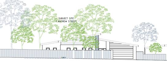
The provision of high solid front fencing
is not considered to be uncharacteristic within the immediate context of the
site and surrounding area with it noted that the following properties within
the immediate context of the site contain high fencing of various materials and
heights along street frontages (see attachment):
· 3
Andrew, Street Forest Hill;
· 4
Andrew Street, Forest Hill;
· 18
Andrew Street, Forest Hill;
· 40
Menin Road, Forest Hill;
· 54
Menin Road, Forest Hill;
· 56
Menin Road, Forest Hill;
· 59
Shady Grove, Forest Hill;
· 68
Shady Grove, Forest Hill;
· 68A
Shady Grove, Forest Hill;
· 1
Fisher Street, Forest Hill, and
· 6
Fisher Street, Forest Hill.
Whilst is acknowledged that the
Bush Environment Character Precinct guidelines seek that either no or low front
fencing be erected, the above sites evidence that there is an existing
character for front fencing within the immediate context of the site.
The applicant has acknowledged that the provision of high
solid front fencing is of significant concern to the community following forum,
and has since put forward a concept front fence plan (see attachments) seeking
to soften the materiality of the proposed fence and to provide for more
transparency at dwelling frontage, through the use of wrought iron infills
between existing piers and the changing of horizontal timber slats to vertical
slats (see below):
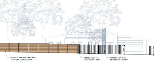
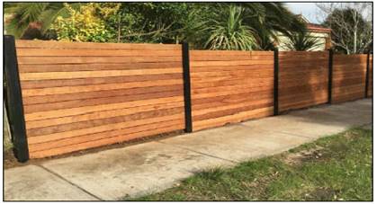
Officers acknowledge that this is
an improvement from that which was originally proposed, it is considered that
the revised scheme does not go far enough in addressing objectors concerns and
ensuring consistency with preferred neighbourhood character.
As such, it is noted that a
condition will be placed on permit requiring the fence to be setback 0.5 metres
from boundary (so as to allow for the provision of small scale landscaping at
frontage) and that the wrought iron infill be extended to be the full length of
the dwelling (so as to increase transparency from street frontage and provided
for further softening). It is considered that this is more in line with keeping
with the existing fencing character of the area and will allow for an
appropriate balancing of the streetscape.
CONCLUSION
The proposal for construction of
one (1) dwelling on a lot and removal of vegetation within the Significant
Landscape Overlay - Schedule 6 is an acceptable response that satisfies the
relevant provisions contained within the Whitehorse Planning Scheme, including
the State and Local Planning Policies, the Neighbourhood Residential Zone
– Schedule 1 and Significant Landscape Overlay – Schedule 6.
The proposed development’s
form, siting and overall design is acceptable and will integrate into the
existing built form and character.
A total of twenty (20) objections
were received as a result of public notice and all of the issues raised have
been discussed as required.
It is considered that the
application should be approved.
Attachment
1 Decision Plans 
2 Concept Fence
Design
3 Existing Street
Front Fencing Photos 
Council Meeting 30
November 2020
9.1.3 129-133
Burwood Highway, Burwood (Lot 1 TP 254250, Lot 1 TP 429285, LOT 1 PS
338433H) Construction of a part five part six storey building, with
basement car park, buildings and works within 4 metres of trees (SLO9) and
alteration of access to a road in a Road Zone, Category 1
FILE NUMBER: WH/2020/677
ATTACHMENT
SUMMARY
This application is the third
for this site, with the two previous applications being refused by Council and
also refused by VCAT. This third application seeks to address the key matters
outlined in the last VCAT decision.
This application was advertised,
and a total of 144 objections were received. The objections raised key issues
with neighbourhood character, non-compliance with planning controls, amenity
impacts, car parking and traffic, landscaping and internal amenity.
A Consultation Forum was held via
teleconference (Zoom) on 19 October 2020 chaired by an external
facilitator (no Councillors attended as this was held during caretaker period)
with the assistance of Council’s planning officers. The forum was
attended by approximately 18 objectors. At this Forum key objection themes were
discussed, however there was no resolution of issues. Subsequently no
resolution was reached between the parties.
This report assesses the application against the relevant
provisions of the Whitehorse Planning Scheme, the objector concerns and the key
matters outlined by VCAT in the 2019 decision on the second application for the
site. It is recommended that the application be supported, subject to
conditions.
RECOMMENDATION
That Council:
A Being the Responsible Authority, having
caused Application WH/2020/677 for 129-133 Burwood Highway, BURWOOD (LOT 1 TP
254250, LOT 1 TP 429285, LOT 1 PS 338433H) to be advertised and having received
and noted the objections is of the opinion that the granting of a Planning
Permit for the construction of a part five storey and part six storey building,
with basement car park, buildings and works within 4 metres of protected trees
(SLO9) and, alteration of access to a road in a Road Zone, Category 1 is acceptable
and should not unreasonably impact the amenity of adjacent properties.
B Issue a Notice of Decision to Grant a
Permit under the Whitehorse Planning Scheme to the land described as 129-133
Burwood Highway, burwood (LOT 1 TP 254250, LOT 1 TP 429285, LOT 1 PS 338433H
47B) for the construction of a part five storey and part six storey building,
with basement car park, buildings and works within 4 metres of protected trees
(SLO9) and, alteration of access to a road in a Road Zone, Category 1, subject
to the following conditions:
1. Before the development starts, or any trees or
vegetation removed, amended plans and documents must be submitted to and
approved by the Responsible Authority. The plans must be drawn to 1:100
scale, with dimensions, and be generally in accordance with the plans
identified as Revision TPO1, prepared by CHT Architects, dated 9th July
2020, but modified to show:
Built form and layout
a) Dwelling
3.01 deleted.
b) The
north facing balcony area of Dwelling 2.01, recessed and absorbed into the
building form, to reduce the building protrusion at this point.
Screening and glazing
c) The
screening application type proposed on any windows or balcony to be fully
detailed on elevation and suitably demonstrated compliance with the objective
and standards of Clause 55.04-6 of the Whitehorse planning Scheme.
d) The
north facing balcony of Dwelling 2.09, to achieve screening in accordance with
Clause 55.04-6 of the Whitehorse Planning Scheme
Site Services
e) Details
of how service cabinets, along Burwood Highway, will be screened/finished, so
as to reasonably integrate into the overall development scheme.
f) Roof
plan illustrating all plant and equipment with screening ensuring views from
all street frontages are obscured. The screening should be lowered to
minimum height possible and be of lighter colouring and no-solid material.
Material and urban design
g) Provision
of horizontal separation (100 – 200mm) between the masonry lower ground
and the precast concrete over to assist with articulation of the architectural
form.
h) A
separate sheet with a full schedule of materials and finishes with colour
samples of all external walls, roofs, fascia, window frames, paving (including
terraces, balconies, roof terraces, stairs), fencing, privacy screens, roof top
plant screens and retaining walls. This is to include:
i. The screening for west facing windows, fronting
Roslyn Street and the dwelling at 2A Roslyn Street to comprise a range of
materials.
ii. The use of suitable material to the under balconies that
extend from the building line.
iii. Confirmation that the colour of the precast is embedded in the
concrete mix and not a painted finish.
i) Integration
of Engineering and Environmental Services requirements into the plans as
necessary, as follows:
i. Prior to construction works commencing a Car Parking
Management Plan is to be submitted in accordance with Condition 3
ii. The gradients within the proposed ramp and grade changes
to the basement to be designed in accordance with AS 2890.2.
j) All
modifications to the plans as specified in Condition 5 amendment to the
Sustainability Management Plan.
k) All
modifications to plans as required by Condition 3 and Conditions 23 to 30,
Drainage and Assets.
All of the above must be to
the satisfaction of the Responsible Authority. Once approved, these plans
become the endorsed plans of the permit.
2. The
layout of the site and the size, design and location of the buildings and works
permitted must always accord with the endorsed plan and must not be altered or modified
without the further written consent of the Responsible Authority.
Car Parking Management Plan
3. Prior
to the commencement of any buildings or works, a Car Parking Management Plan,
detailing how car and bicycle parking areas, accessways and waste collection
bays will be allocated and managed, must be submitted to and approved by
Responsible Authority.
This plan is to be to the
satisfaction of the Responsible Authority and must include, but is not limited
to, the following:
a) Allocation
of all parking spaces (except visitor spaces) to individual dwellings and
procedures to allocate disabled car spaces to residents/visitors as
required.
b) Pedestrian
access and movement within the car parking areas, including strategies to
minimise the potential for conflict between pedestrians and vehicles.
This may include line marking such as hatched shared areas, direction signs
and/or physical barriers.
c) Allocation
of bicycle spaces to tenancies and visitors.
d) Directional
signs to car and bicycle parking spaces and facilities.
e) Location
of bicycle parking signs in accordance with Clause 52.34-5.
f) Line
marking of parking spaces.
g) How
parking will be secured and details of how access to car spaces, disabled car
spaces and bicycle spaces will be achieved by visitors and delivery vehicles as
required (via an intercom).
h) Details
of how access to the waste collection areas will be achieved by waste
collection vehicles. The collection area cannot be within the access
aisle and must demonstrate how these areas will be secured.
i) Advise
where delivery vehicles and moving vans serving the dwellings will park.
These vehicles must be able to park for a reasonable period of time in
convenient locations.
j) How
the car park will be managed to ensure that all vehicles exit the site in a
forwards direction.
Once submitted to and approved
by the Responsible Authority, the Car Parking Management Plan will form part of
the documents endorsed as part of this planning permit.
The requirements of the Car
Parking Management Plan must be implemented by the building manager, owners and
occupiers of the site for the life of the building, to the satisfaction of the
Responsible Authority.
4. Prior
to commencement of any building and works which have any impact to the road
reservation and existing trees, a Construction Impact Assessment and Tree
Management Plan is to be prepared for these trees by a suitably qualified
arborist, detailing construction methodologies and tree protection measures to
the satisfaction of the Responsible Authority.
Sustainability Management
Plan
5. Prior to the commencement of
any buildings or works, an amended Sustainability Management Plan (SMP) must be
submitted to and approved by the Responsible Authority. This SMP must be
generally in accordance with the SMP submitted with the application but amended
to include the following changes:
a) A
complete, ‘Published’ BESS Report, with an acceptable overall score
that exceeds 50% and exceed the ‘pass’ marks in the categories of
Water, Energy Stormwater and Indoor Environment Quality (IEQ) or that is
otherwise to the satisfaction of the Responsible Authority.
b) A
minimum 50,000 litre rainwater tank connected to the development’s entire
roof area.
c) An
annotation on Development Plans indicating the capacity of the rainwater tank
and that the capacity stated is allocated exclusively for reuse/retention
purposes and excludes any volume allocated for detention.
d) Appropriate
access to maintain and service the rainwater tank must be demonstrated on Development
Plans.
e) That
all toilet services and irrigation areas throughout the development are
facilitated by the rainwater tank, annotated on Development Plans.
f) Water
efficient fixtures and fittings include minimum 5 star WELS taps, 4 star WELS
toilet, 3 star WELS showerheads (≤ 7.5 L/min) and 4 star WELS urinals.
g) Daylight
modelling assessment to the satisfaction of the Responsible Authority.
h) Natural
ventilation with all operable windows, doors, terrace openings and vents
provided in elevation drawings.
i) Preliminary
NatHERS Energy Efficiency Assessments for 50% of the total amount of dwellings
within the development. The assessment, as a whole, must ensure that
thermally unique dwellings have been modelled, representative of an equitable,
average, performance of the development. Each dwelling must demonstrate
that the development will achieve cooling loads ≤ 21 MJ/m2/annum.
Assessments must demonstrate an average NatHERS energy efficiency star rating
of 6.5 achieved throughout the development with no dwelling performing below
5.5 stars. Indicative commitments towards thermal performance (i.e.
R-values), artificial lighting and glazing (i.e. U- and SHGC- values) for
residential areas must be provided.
j) LED
light fittings used to provide artificial lighting and designed to exceed
National Construction Code 2019 Building Code of Australia requirements.
k) Energy
efficient heating, cooling and hot water systems indicating the associated COP
and EER values or energy efficiency star ratings.
l) Exterior
building services equipment including any heating, cooling, ventilation, hot
water and renewable energy systems on Development Plans.
m) A
minimum 22 kilowatt solar photovoltaic system.
n) Double
glazing for all external windows.
o) Car
park ventilation fitted with CO sensors.
p) Car
park lighting, where reasonably safe to do so, fitted with motion sensors or
timers.
q) All
common, external, service and lift area lighting fitted with sensors or timers.
r) Common,
service and lift area ventilation fitted with sensors or timers.
s) The
location of alternative transport facilities including residential and visitor
secure bicycle spaces, demonstrated on Development Plans.
t) A
commitment to divert at least 80% of construction and demolition waste from
landfill.
u) Use
of low Volatile Organic Compound (VOC) and formaldehyde products.
v) Include
an annotation of that the timber species intended for use as decking or outdoor
timber are not unsustainably harvested imported timbers (such as Merbau, Oregon,
Western Red Cedar, Meranti, Luan, Teak etc.) and meet either Forest Stewardship
Council or Australian Forestry Standard criteria with a commitment provided as
an annotation on Development Plans.
w) Where
measures cannot be visually shown, include a notes table or ‘ESD
Schedule’ on Development Plans providing details of the requirements
(i.e. average energy rating for the development’s dwellings, % energy
efficiency improvement, energy and water efficiency ratings for
heating/cooling, hot water and plumbing fittings and fixtures etc.).
All of the above is to be to
the satisfaction of the Responsible Authority.
Once submitted and approved to
the satisfaction of the Responsible Authority, the SMP will form part of the
endorsed plans under this permit.
The requirements of the SMP
must be demonstrated on the plans and elevations submitted for endorsement, and
the requirements of this plan must be implemented by the building manager,
owners and occupiers of the site when constructing and fitting out the building,
and for the duration of the building's operation in accordance with this
permit, to the satisfaction of the Responsible Authority.
Landscape Plan
6. Before the development
commences, a Landscape Plan to the satisfaction of the Responsible Authority
must be submitted to and approved by the Responsible Authority. When approved,
the Landscape Plan will be endorsed and will form part of this permit. The
Landscape Plan must:
a) Any
changes resultant from Condition 1 requirements.
b) Notate
the type, location, quantity, height at maturity and botanical names of all
proposed plants.
c) Nomination
of all proposed services.
d) Details
of all containerised planting infrastructure.
e) Detail
the design (including the provision of sections) and layout of the common area,
planters and ground level planting areas;
f) Provide
a specification of works to be undertaken prior to planting;
g) Further
detail on any sustainable treatments and water harvesting methods ;and
h) Detail
plant/planting maintenance schedules and requirements to the satisfaction of
the Responsible Authority.
Landscape Maintenance Plan
7. Prior
to the occupation of the approved building, a Landscaping Maintenance Plan,
prepared by a suitably qualified consultant, must be submitted and approved by
the Responsible Authority. The landscaping maintenance plan must include,
but is not limited to:
a) Irrigation
system/program for street trees and street level garden beds, including details
of frequency and water delivery method.
b) Details
of the ongoing maintenance procedures to ensure that the garden areas in the
communal open space at Level 4 are healthy and well maintained to the
satisfaction of the Responsible Authority. This must include:
i. Irrigation frequency and delivery method.
ii. Drainage.
8. Before
the building is occupied, or by a specified later date, as approved in writing
by the Responsible Authority, the landscaping works shown on the endorsed
Landscape Plan must be carried out and completed to the satisfaction of the
Responsible Authority. The landscaping shown on the endorsed Landscape Plan
must achieve at all times:
a) Compliance
with the provisions, recommendations and requirements of the endorsed Landscape
Plan;
b) Compliance
so that areas set aside on the endorsed Landscape Plan for landscaping are not
be used for any other purpose; and
c) Replacement
of any dead, diseased, dying or damaged plants, to the satisfaction of the
Responsible Authority.
9. No street tree may be removed
without the prior written consent of the Responsible Authority.
Construction Management Plan
(CMP)
10. Prior
to the commencement of buildings or works on the land, a Construction
Management Plan, detailing management of the environmental and construction
issues associated with the development, must be submitted to and approved by.
The Construction Management
Plan must be prepared and managed by a suitably qualified person who is
experienced in preparing Construction Management Plans in accordance with the
City of Whitehorse Construction Management Plan Guidelines.
When approved, the
Construction Management Plan will form part of this permit and must be complied
with, to the satisfaction of the Responsible Authority, to the extent that this
is in the control of the owner of the land. The owner of the land is to be
responsible for all costs associated with the works to be undertaken in
accordance with the requirements of the Construction Management Plan.
11. The
provisions, recommendations and requirements of the endorsed Construction
Management Plan must be implemented and complied with to the satisfaction of
the Responsible Authority.
Waste Management Plan (WMP)
12. Prior
to the commencement of any buildings or works, an amended Waste Management Plan
(WMP) must be submitted to and approved by the Responsible Authority. This WMP
must be generally in accordance with the WMP submitted with the application but
amended to show:
a) Waste
Generation Rates:
i. General/domestic waste: 4,000 L/week.
ii. Recycling: 5,664 L/week.
iii. Bulk Waste: To be advised.
iv. Hard Waste: As arranged through private contractors.
v. Green Waste: Minimal – assumed private
contractor who will remove materials from the site.
b) Proposed
MGB configurations:
i. General/domestic waste: 6 no. 660L
MGB’s @ 1 coll./week.
ii. Recycling : 9 no. 660L
MGB’s @ 1 coll./week,
Or
i. General/domestic waste: 4 no. 660L
MGB’s @ 2 colls./week.
ii. Recycling: 5 no. 660L MGB’s @ 2
colls./week.
c) The
residential bin storage room shown on the lower ground floor needs to
accommodate areas for the following:
i. Storage of bulk items (cardboard etc.)
ii. Hard waste.
iii. Charity bin.
d) Clearly
state in the WMP the use of a double (waste & recycling) chute system.
13. The
requirements of the endorsed Waste Management Plan, forming part of this
permit, must be implemented by the building manager, owners and occupiers of
the site for the life of the building, to the satisfaction of the Responsible
Authority.
Drainage and Assets
14. All
stormwater drains and on-site detention systems are to be connected to the legal
point of discharge to the satisfaction of the Responsible Authority prior to
the occupation of the building/s. The requirement for on- site detention
will be noted on your stormwater point of discharge report, or it might be
required as part of the civil plans approval.
15. Detailed
stormwater drainage and/or civil design for the proposed development are to be
prepared by a suitably qualified civil engineer and submitted to the
Responsible Authority for approval prior to occupation of the development.
Plans and calculations are to be submitted with the application with all levels
to Australian Height Datum (AHD). All documentation is to be signed by
the qualified civil engineer.
16. Stormwater
that could adversely affect any adjacent land shall not be discharged from the
subject site onto the surface of the adjacent land.
17. Prior
to works commencing the Applicant/Owner is to submit design plans for all
proposed engineering works external to the site. The plans are to be
submitted as separate engineering drawings for assessment by the Responsible
Authority.
18. The
Applicant/Owner is responsible to pay for all costs associated with
reinstatement and/or alterations to Council or other Public Authority assets as
a result of the development. The Applicant/Owner is responsible to obtain
all relevant permits and consents from Council at least 7 days prior to the
commencement of any works on the land and is to obtain prior specific written
approval for any works involving the alteration of Council or other Public
Authority assets. Adequate protection is to be provided to
Council’s infrastructure prior to works commencing and during the
construction process.
19. The
qualified civil engineer when undertaking civil design must ensure that the
landscape plan/s and drainage plan/s are compatible. The stormwater
drainage and on site detention system must be located outside the tree
protection zone (TPZ) of any trees to be retained.
20. Applicant
must allow for the design and construction of an outfall drain along the full
length of the drainage easement to cater for upstream properties east side of
Roselyn Street. Drain to be designed for a 10% ARI and existing outfall
drain to be checked for the same.
21. Offset
of building from easement may need to change due to the vicinity of new
drain. The applicant must apply for Report and Consent – Building
over the Easement prior to approval of the Planning Permit. Plans must
show location of existing sewer and location of new outfall drain (for upstream
properties).
22. No
trees are permitted within the easement. Any planting must not affect the
new stormwater pipe within the easement and have shallow roots that do not
impact upon the functionality of the stormwater pipe. Please reflect this
on the landscaping plans. Councils arborist must approve the landscaping
plans
Amenity
23. Noise
from any fixed domestic plant must not be audible within a habitable room of
any other residence during prohibited hours prescribed by the Environment
Protection (Residential Noise) Regulations 2008 and the Public Health and
Wellbeing Act 2008.
Building Services
24. The
development must provide the capacity for television signal distribution to
each dwelling unit and any satellite dish, antenna or similar structure must be
designed and located at a single point to the satisfaction of the Responsible
Authority.
25. All
building plant and equipment on the roofs, balcony areas, common areas and
public thoroughfares is to be concealed to the satisfaction of the Responsible
Authority. Noise emitting plant equipment such as air conditioners, must be
shielded with acoustic screening to prevent the transmission of noise having
detrimental amenity impacts. The construction of any additional plant,
machinery or other equipment, including but not limited to all service
structures, down pipes, aerials, satellite dishes, air-conditioners, equipment,
ducts, flues, all exhausts including car parking and communication equipment
must include appropriate screening measures to the satisfaction of the
Responsible Authority.
26. All
mechanical exhaust systems for the car park hereby approved must be located and
sound attenuated to prevent noise and general nuisance to the occupants of the
surrounding properties, to the satisfaction of the Responsible Authority.
Department of
Transport
27. Prior
to the occupation of the development, all vehicle crossings on Burwood Highway
must be removed, and the area reinstated to kerb and channel, to the
satisfaction of the Responsible Authority and at no cost to the Head, Transport
for Victoria.
Expiry
28. This
permit will expire if one of the following circumstances applies:
a) The
development is not commenced within three (3) years from the date of issue of
this permit;
b) The
development is not completed within five (5) years from the date of this
permit;
C Has made this decision having particular regard
to the requirements of Sections 58, 59, 60 and 61 of the Planning and
Environment Act 1987.
MELWAYS
REFERENCE 60 J6
|
Applicant: Imax
Land (Australia) Pty Ltd
Zoning: Residential
Growth Zone – Schedule 1 (RGZ1)
Overlays: Significant
Landscape Overlay – Schedule 9 (SLO9)
Relevant Clauses:
Clause 11 Settlement
Clause
11.03-1S Activity Centres
Clause 15 Built
Environment and Heritage
Clause
15.01-1S Urban Design
Clause
15.01-2S Building Design
Clause
15.01-5S Neighbourhood
Character
Clause
15.02-1S Energy and Resource
Efficiency
Clause
16.01-1S Housing Supply
Clause
16.01-1R Housing Supply
– Metropolitan Melbourne
Clause
16.01-3S Housing
Affordability
Clause
18.02-1S Sustainable Personal
Transport
Clause
18.02-2S Public Transport
Clause
19.03-2S Infrastructure
Design and Provision
Clause 21.01 Municipal
Profile
Clause 21.05 Environment
Clause 21.06 Housing
Clause 22.03 Residential
Development
Clause 22.04 Tree
Conservation
Clause 22.06 Activity
Centres
Clause 22.10 Environmentally
Sustainable Development
Clause 32.07 Residential
Growth Zone Schedule 1
Clause 42.03 Significant
Landscape Overlay Schedule 9
Clause 52.06 Car
Parking
Clause 52.29 Land
Adjacent to a Road Zone, Category 1
Clause 52.34 Bicycle
Facilities
Clause 53.18 Stormwater
Management in Urban Developments
Clause 58 Apartment
Developments
Clause 65 Decision
Guidelines
Ward: Wattle
|
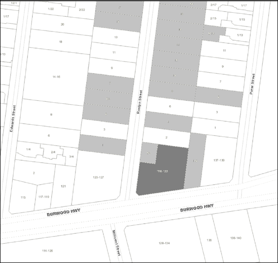
|
|
|
Subject site
|
|
18 Objector Properties
(72 outside of map)
|
é
North
|
|
|
|
|
|
Please
note, there a number of objector properties which had multiple objections.
|
|
BACKGROUND
History
Planning application WH/2015/109
sought permission for the development of the land for a three storey building
comprising 7 dwellings and reduction in car parking requirements at 129 Burwood
Highway, Burwood and was approved in August 2015. This permit was never acted
upon.
Planning Application WH/2014/746
sought planning permission for the use and development of the land for one 5
storey building and one 7 storey building comprising 206 dwellings and ground
floor retail, reduction in car parking requirement and loading area, and
alteration of access to a Road Zone Category 1 for the land at 133 and 145
Burwood Highway, Burwood and was refused in 2015.
Planning application WH/2016/1131
sought planning approval for construction of a part five, part six storey
building with two levels of basement car parking (comprising 60 dwellings),
lower ground level food and drink premises (café), reduction of car
parking, waiver of the loading and unloading bay requirements, and alteration
of access to a Road Zone Category 1. The applicant lodged an application for
review to VCAT against Council’s failure to determine the application
within time, however the position of officers was that the application should
not be supported. The Tribunal upheld the Council position and ordered
that no permit issue.
Planning application WH/2018/258
sought approval for construction of part five, part six storey building with
two levels of basement car parking (comprising of 50 dwellings). The
application was refused by Council on 10 August 2020. The applicant
lodged an application for review to VCAT of council’s decision. The
Tribunal determined that the failings of the previous application had not been
sufficiently addressed and again upheld the decision of Council, ordering that
no permit issue.
The Site and Surrounds
The subject site is located on the
north-eastern corner of Burwood Highway and Roslyn Street, Burwood. The subject
site has a frontage to Burwood Highway of approximately 47.5 metres, a frontage
to Roslyn Street of approximately 30 metres and a total site area of
approximately 1827 square metres.
The site was previously occupied by
one dwelling on each of the three properties at 129, 131 and 133 Burwood
Highway, with 129 Burwood Highway deriving vehicle access from Roslyn Street.
Numbers 131 and 133 Burwood Highway obtain vehicular access from Burwood
Highway. The buildings on each property were demolished in January 2017
and the lots were levelled (works that do not require planning approval).
The land has a fall from Burwood
Highway toward the rear (south) of approximately 4.1 metres across the site.
The finished surface level of the site is higher than the adjoining footpath to
the south, with low brick front fences also serving as retaining walls.
As part of the demolition works the site was levelled/battered to the
footpaths. The subject site does not contain any vegetation as trees and shrubs
were removed at the time when the buildings were demolished.
The site is located within walking
distance of retail and other services, numerous education facilities including
Deakin University, recreation areas including Wattle Park and located
immediately opposite the Route 75 Tram line. Numerous buses provide easy access
to nearby activity centres including the Box Hill MAC.
Burwood Highway is an arterial road
running east-west, extending past the southern boundary of the subject site. In
the vicinity of the site, Burwood Highway provides two traffic lanes in either
direction separated by a dedicated central tramway. Kerbside parking is not
permitted.
Roslyn Street is a local road
running north-south, between Patterson Avenue in the north and Burwood Highway
in the south. Roslyn Street operates as a two-way road, with kerbside parallel
parking permitted on both sides of the road.
Figure
1 – Aerial imagery of the subject site.
The immediate context comprises:
South:
· Land
on the opposite (south) side of Burwood Highway generally consists of
properties located within the Burwood Village Shopping Centre and are all
contained within a Commercial 2 Zone.
West:
· On
the opposite side of Roslyn Street, at 123-127 Burwood Highway, is land in a
Public Park and Recreation Zone, known as Roslyn Street Reserve. This local
park contains children’s play equipment, trees, and open lawn area.
· Directly
abutting the north-western section of the subject site is 2A Roslyn Street.
This property is contained within the General Residential Zone, Schedule 1. It
contains a single storey brick dwelling with attached double garage. The
dwelling is oriented to the west (toward Roslyn Street). There is an undercover
patio located at the rear. The dwelling has a blank wall constructed on the
common (southern) boundary with the subject land and a range of habitable room
windows in the east elevation of the dwelling. Secluded private open space
adjoins the common western boundary with the subject land.
East:
· Land
to the west of the subject site, up to the edge of Parer Street, is contained
within the Residential Growth Zone Schedule 1.
· 135
Burwood Highway is currently occupied by a single storey weatherboard dwelling
with gable roof. Private open space for this dwelling is located to its north
(rear). Vehicle access is provided from the Burwood Highway.
· 137-139
Burwood Highway has a newly constructed five storey building comprising 50
dwellings.
North:
· To
the north of the subject land, properties are contained within the General
Residential Zone Schedule 1.
· 2
Roslyn Street is occupied by a single storey weatherboard dwelling, with a
single vehicle carport in the frontage. Secluded private open space is located
to the south of the dwelling, and adjoins the common boundary with the subject
land.
The site is located within the
Burwood Village Neighbourhood Activity Centre, which is centred around the
intersection of Warrigal Road and Burwood Highway. It provides retail,
education, office, civic, medical, community facilities, entertainment, dining
and recreational opportunities, as well as a hub for local community
activities.
The Burwood Village Neighbourhood
Activity Centre Framework Plan was adopted by Council in December 2009 and was
introduced as a reference document in the Whitehorse Planning Scheme. This
Framework Plan identified the area surrounding the subject site as being
characterised by land used for the purposes of retail, office, light industrial
and commercial uses, with a notable presence of motor vehicle sales. Built form
was identified as eclectic, utilitarian commercial building forms of 1-3
storeys. The Framework Plan identified the subject land as presenting an
opportunity for non-residential use or more intensive residential development.
It was envisaged that this area would be suitable for substantial change, where
built form would include three storey dwellings and medium density housing.
Planning Controls
The subject site is zoned
Residential Growth Schedule 1, and is covered by the Significant Landscape
Overlay Schedule 9.
Residential Growth Zone –
Schedule 1 (RGZ1)
The purpose of the Residential
Growth Zone includes:
· To
provide housing at increased densities in buildings up to and including four
storey buildings.
· To
encourage a diversity of housing types in locations offering good access to
services and transport including activity centres and town centres.
· To
encourage a scale of development that provides a transition between areas of
more intensive use and development and other residential areas.
· To
allow educational, recreational, religious, community and a limited range of
other non-residential uses to serve local community needs in appropriate
locations.
A permit is required for the
construction of two or more dwellings on a lot and Residential Buildings.
Significant Landscape Overlay
– Schedule 9 (SLO9)
The land is included in the
Significant Landscape Overlay (Schedule 9), clause 42.03 of the Whitehorse
Planning Scheme.
A planning permit is required for
buildings and working within 4 metres of protected trees. In this
instance a planning permit is required for works within 4 metres of Tree 1
(Street Tree – along Roslyn Street frontage).
Land
Adjacent to a Road Zone, Category 1
In accordance with Clause 52.29
(Access to a Road Zone, Category 1), planning permission is required for
alteration of access to a road in a Road Zone Category 1 (Burwood Highway),
including the removal of existing access points.
PROPOSAL
The proposal comprises the
construction of an apartment style residential building (part 5-storey, part 6-
storey in height), above two (2) levels of basement car parking. The building
will contain 44 dwellings, 58 resident parking spaces and 7 visitor parking
spaces) and the proposal includes alteration of access to a road in a Road Zone
Category 1 (Burwood Highway).
Details of the proposal are as
follows:
Lower Basement and Basement
· The
basement contains two levels of car parking, storage cages, bicycle parking,
lift and stair access and water tanks/building services.
· The
basement levels comprise a total of 58 car parking spaces for residents.
· The
lower ground floor comprises 12 residential and 2 visitor car parking spaces.
· Both
levels of the basement will be setback 2.0 metres from the site’s
northern boundary, and 3 metres from the eastern boundary.
Lower Ground Floor
· The
lower ground comprises storage cages, 9 car parking spaces (2 residents and 7
visitors), bicycle parking, lift and stair access, substation/ building
services, waste storage room and lobby area.
· Pedestrian
access to the apartment building via the southern interface (Burwood Highway),
which leads to a lobby area, with direct access to the mail room, bicycle
workshop, as well as the lift and stair access.
· Ground
level footprint is set back three metres (minimum) from the eastern boundary
(interface with 135 Burwood Highway) and four metres from the southern boundary
(Burwood Highway), with terraces and landscaping within the southern setback
area.
· The
south eastern portion of the building at this level comprises three dwellings
of mixed typologies (two x 1-bedroom and one x 2-bedroom dwelling).
Ground Level
· Vehicular
access to the car parking areas via a crossover (5.5 metres wide) on Roslyn
Street.
· There
are 10 dwellings located at the ground floor comprising a mix of two and three
bedroom typologies (eight x 2-bedroom, two x 3-bedroom dwellings).
· Given
the fall of the land to the east, dwellings identified on the plans as G.07,
G.08, G.09 and G.10 are provided with ground level terraces (between 44.86
square metres and 164.8 square metres). Other dwellings on this level have
balconies ranging from 8 to 14.5 square metres. The terraces and balconies will
have aspect toward landscape zones around the site’s edges.
· The
ground floor level is set back a minimum of 4 metres from the northern
boundary, 3.05 metres from the eastern boundary, 4 metres from the southern
boundary (Burwood Highway), 3 metres from Roslyn Street and between 6.1 to 12.5
metres from 2a Roslyn Street (western boundary).
First Floor
· Twelve
(12) dwellings are located at first floor level comprising a mix of one, two
and three bedroom typologies (4 x 1-bedroom, 6 x 2-bedroom and 2 x 3-bedroom).
· Dwelling
balconies range in size from 8.3 square metres to 18.6 square metres.
· A
‘T-shaped’ central corridor provides access from the lift and
stairwell to apartments, which has been provided with an operable window for
natural ventilation and light.
· The
first floor level has been set back a minimum of 4 metres from the northern
boundary, 3.05 metres from the eastern boundary, 4 metres from Burwood Highway,
3 metres from Roslyn Street and between 6.1 to 12.5 metres from 2a Roslyn
Street (western boundary).
Second Floor
· Nine
(9) dwellings are located at second floor level comprising a mix of one, two
and three bedroom typologies (2 x 1-bedroom, 6 x 2-bedroom, 1 x 3-bedroom).
· Dwelling
balconies range in size from 8.3 square metres to 26.78 square metres.
· A
‘T-shaped’ central corridor provides access from the lift and
stairwell to apartments, which has been provided with an operable window for
natural ventilation and light.
· The
second floor level has been set back a minimum of 10.375 metres from the
northern boundary, 5.02 metres from the eastern boundary, 4 metres from Burwood
Highway, 3 metres from Roslyn Street and 11.2 metres from 2a Roslyn Street
(western boundary).
Third Floor
· Eight
(8) dwellings are located at third floor level comprising a mix of one, two and
three bedroom typologies (3 x 1-bedroom, 4 x 2-bedroom, 1 x 3-bedroom).
· Dwelling
balconies range in size from 8.47 square metres to 15.7 square metres.
· A
‘T-shaped’ central corridor provides access from the lift and
stairwell to apartments, which has been provided with an operable window for
natural ventilation and light.
· The
third floor level has been set back a minimum of 13.075 metres from the
northern boundary, 5.02 metres from the eastern boundary, 4 metres from Burwood
Highway, between 3 metres and 20.2 metres from Roslyn Street and 11.2 metres
from 2a Roslyn Street (western boundary).
Fourth Floor
· Two
(2) dwellings are located at fourth floor level which are both 3-bedroom
dwellings.
· Dwelling
balconies range in size from 17.1 square metres to 26.5 square metres.
· A
communal area of 152.85 square metres, comprising of an outdoor terrace space
of 110.83 square metres and an indoor area of 42.02 square metres.
· An
‘L-shaped’ central corridor provides access from the lift and
stairwell to apartments, which has been provided with an operable window for
natural ventilation and light.
· The
fourth floor level has been set back a minimum of 19.5 metres from the northern
boundary, 8.64 metres from the eastern boundary, 8 metres from Burwood Highway,
3 metres from 2 Roslyn Street and 11.2 metres from 2a Roslyn Street (western
boundary).
General
· Maximum
building height of approximately 21 m above natural ground level (including a
1.4m high lift overrun and plant area).
· The
building utilises a varied palette of contemporary materials of precast
concrete panels, masonry and metal cladding.
· The
building presents as four storey built form to 2a and 2 Roslyn Street due to
the fall of the land and six storeys in part, along Burwood Highway and five
storeys along Roslyn Street frontage.
CONSULTATION
Public Notice
The application was advertised by
mail to the adjacent property owners and occupiers and by erecting two notices
on site, along Roslyn Street and Burwood Highway frontage. Following the
advertising period one hundred and forty four (144) objections were
received. The issues raised in the objections can be summarised into the
following key themes:
a) Amenity
impacts –
i. Overlooking
ii. Overshadowing
iii. Increased
noise from use and from services
iv. Emission
of dust and dirt on the road
v. Noise
and headlight impact of the basement ramp adjacent to a bedroom wall.
vi. Reduced
safety.
vii. Impact
on personal health and wellbeing.
viii. Construction
impacts
b) Neighbourhood
character –
i. Building
height is out of keeping with the neighbourhood
ii. Part
five, part six-storey built form is too close to General Residential Zoned
dwellings to the north
iii. Inadequate
setbacks and transitions provided to surrounding residential lots.
iv. Insufficient
tree planting, not in character with the surrounding area.
c) Internal
Amenity
i. Insufficient
private and communal open space
ii. Lack
of amenity services for future residents.
d) Car
parking and traffic –
i. Increased
traffic along Roslyn Street and surrounding residential streets
ii. Impact
of additional traffic on the intersection of Burwood Highway
iii. Insufficient
on-site car parking
iv. Visitors
to apartments will not typically utilise basement parking provided
v. Increased
demand – on-street parking
vi. Suitability
of the entry location to the proposed basement, off Roslyn Street.
vii. Traffic
and pedestrian safety impacts
e) Landscaping
–
i. Insufficient
landscaping, out of character.
ii. Impact
on existing vegetation
f) Compliance
with planning controls –
i. Contrary
to Zone and Policy requirements.
g) Non-planning
matters –
i. Negative
impact on surrounding property values.
ii. Increased
pressure on local infrastructure.
iii. This
is the third application for this site.
iv. Profiteering.
Consultation Forum
A Consultation Forum was held on
Monday 19 October 2020 via teleconference (Zoom). Approximately 18
objectors attended the meeting, which was chaired by an external planning
consultant, and also attended by 3 planning officers
Objectors raised general issues
relating to amenity, particularly overshadowing, overlooking, loss of views,
noise (from waste collection, air conditioning, waste collection and vehicle
movements), visual impact, setbacks and traffic and parking. The issues that
drew most discussion on the night related to:
· Neighbourhood
character in terms of the height and appearance of the proposed building.
· Adequate
car parking and traffic disruptions to other residential properties including
during construction.
· Extent
of trees that have been removed from site and concern about replanting of trees
only being minimal.
· Direct
impact of the development on adjoining properties at 2 and 2A Roslyn Street and
135 Burwood Highway.
· Landscape
maintenance, particularly after the development has been constructed.
Despite a robust conversation
amongst parties attending the forum, no resolution of issues were explored.
Subsequently no resolution was reached between the parties.
Referrals
External
Department of Transport (DOT)
The application was referred to the
Department of Transport as a determining authority for the proposed alterations
of vehicular access to Burwood Highway.
DOT has no objection to the
proposed alterations along Burwood Highway, subject to conditional
requirements.
Internal
Engineering and Environmental
Services Department
Transport Engineer
No objection subject to conditions
for the provision of a Car Parking Management Plan.
Waste Engineer
No objection subject to conditions.
Assets Engineer
The proposal was referred to
Council's Asset Engineers who does not object to the proposed development
subject to:
· The
design inclusion for and the construction of an outfall drain along the full
length of the easement to cater for upstream properties east side Roselyn
Street.
· Amended
plans to show the alignment of the Sewer and proposed outfall drain in easement
on all plans and elevations (showing sufficient clearances from both Sewer,
drain and building).
· Standard
drainage conditions.
Planning Arborist
The application was referred to
Council’s Planning Arborist who does not object, subject to tree
protection conditions and amended plans to show the correct location of Tree 3.
ESD Advisor
The application was referred to
Council's ESD Advisor who does not object to the proposal, subject to the
inclusion of conditions on any approval issued.
Urban Design
Urban Design comments were sought
by Council from Hansen Partnership on the submitted plans. These comments
were generally favourable of the proposal. A number of recommendations were
made, which are summarised as follows:
Materials and Finishes
· Provide
some horizontal separation (100 – 200mm) between the masonry lower ground
and the precast concrete over to assist with articulation of the architectural
form. The precast could site proud of the finished masonry line.
· Provide
a different colour/material to the massing above and behind the masonry
façade to Roslyn Street. This will assist in defining this mass
separately to the south west corner mass.
· Introduce
a range of materials that will be used to screen the west facing windows
fronting Roslyn Street and the dwelling at 2A Roslyn Street. These could include
timber or metal and can be effectively used to provide further articulation to
the façade. This will also contribute to improved amenity for residents.
· Identify
a suitable material to exposed soffits of balconies that extend from the
building line.
· Confirm
that the colour of the precast is integral to the concrete mix and not a
painted finish.
· Identify
a different colour to the vertical element at the north western internal
junction to assist in further articulation of the building massing.
Adjoining uses
We consider that all windows to
habitable rooms and balcony spaces that are less than 4.5m from the common
boundary between the subject site and the adjacent site at 135 Burwood Highway
to the East should be adequately screened to prevent future overlooking, or
preferably set back 4.5m from the boundary to ensure future equitable
development. We note that the drawings suggest a 1700mm high screen to affected
windows with 25% visual permeability. We question whether this provides
adequate screening to neighbouring properties. Screens should either be fully
opaque or translucent.
Activation
· Refine
the ground level to make use of the roof spaces over the lower ground floor
– preferably as external balconies to the ground level apartments. This
may require some internal reconfiguration.
· Extend
uses along the southern façade that activate the lower ground level. For
example, swap the bicycle workshop and switchroom with a dedicated entrance to
the bicycle workshop fronting Burwood Highway.
· Provide
the Primary entrance to Apartments LG 1 directly from the street with access
via the lobby considered secondary.
· Provide
the primary entrance to Apartment G.01 From Roslyn Street with access from the
internal corridor considered secondary. We note that a fence and gate is
indicated on the plan. The main entrance should be consistent with an entrance
off Roslyn Street commensurate with the character of other entrances in the
neighbouring residential area to the north, and should include a street address,
post box, and not be concealed behind a tall fence (greater than one metre) and
gate.
· Extend
the balcony (or alternatively include an external deck area) to apartment G.01
near the south west corner of the apartment to improve surveillance over Roslyn
Street and to break up the extent of terraced landscape treatment fronting
Roslyn Street at the South West corner of the proposed development.
· Provide
a direct entrance to Apartment G.10 from Roslyn Street. This should be treated
as the primary access with the internal corridor access considered secondary.
The primary entrance should be consistent with an entrance off Roslyn Street
commensurate with the character of other entrances in the neighbouring
residential area to the north, and should include a street address, post box,
and not be concealed behind a tall fence (greater than one metre) and gate.
· We
do not support the inclusion of a 2m high fence in the location between the
existing dwelling at 2A Rosslyn Street, and the driveway entrance ramp. We
consider that this results in a concealed set back area that would be potential
unsafe and is contrary to accepted CPTED principles. We note that the fence is
labelled ‘acoustic’ which we consider of dubious merit and unclear
as to its purpose. The landscape strip should be redesigned to afford good
surveillance along this corridor space, including the primary access path and
main entrance to apartment G10.
Landscape Architect
The application was referred to
Council Landscape Architect who does not object, however, have requested a
greater number of large canopy trees to be planted.
ParksWide
The proposal was referred to
Council's ParksWide Department who does not object, subject to the inclusion of
conditions on any approval issued to protect the street tree in Roslyn Street.
Strategic Planning
The proposal was referred to Council's Strategic Team who did
not object to the proposed development however have provided the following
comments:
· It
is considered that greater side setbacks of 4.5 metres should be incorporated
at the lower levels of the building to enhance amenity, protect equitable
development rights, and provide for adequate landscaping between buildings. A
greater rear setback is also encouraged to manage the transition to the
adjacent GRZ land.
· The
proposed design presents a four to five storey podium to Burwood Highway
however, we suggest that the top two levels should be recessive in the
streetscape, with a three to four storey podium presentation to Burwood
Highway. This would assist in alleviating the visual impact of the tall
building and would appear to be more in keeping with the approved development
at 137-139 Burwood Highway. It would be helpful to view a Burwood Highway
streetscape elevation that encompasses all properties between Roslyn Street to
Parer Street in order to fully consider the scale of the proposed building in
comparison to the development under construction to the east.
DISCUSSION
The proposal has been assessed
against the relevant state and local planning policies, the zone and overlay
and the relevant particular provisions and general provision of the Scheme.
The following assessment is made
under the headings:
· Response
to previous VCAT Decisions;
· Planning
policy frameworks;
· Design
and built form;
· On-site
and off-site amenity;
· Car
parking, access, traffic and bicycle facilities; and,
· Objectors’
concerns not previously addressed.
Response to previous VCAT
Decisions
As outlined in the background
section of this report, the site has had two previous VCAT determinations, both
of which upheld Council refusals. It is therefore considered that a key
area of assessment for the current application is how the proposal addresses
the failings identified in both of the previous VCAT decisions.
In the 2017 VCAT decision, the
Tribunal made the following key findings:
· That
the redevelopment of the site in the form of a multi-storey apartment building
is supported by policy.
· That
the site and its neighbours between Parer Street and Roslyn Street front
Burwood Highway have a somewhat unique setting.
· That
while exceeding the anticipated four-storey height referred to in the zone
purpose and provisions, the inclusion of a recessive top floor can be supported,
subject to a reduction in its extent to achieve a responsive outcome to the GRZ
which adjoins the land.
· That
the proposed front setback of between 4.0 metres to 6.0 metres can be
considered to be acceptable.
· That
from an overall built form perspective, the development was too tall at the
rear of the site where it was proximate to the GRZ properties.
· That
it was too tall and positioned too close to the boundary and that there was
insufficient justification for the construction of a five-storey built form in
the rear portion of the site.
The more recent VCAT decision
focussed extensively on the matter of the interface with 135 Burwood Highway,
2A and 2 Roslyn Street and the acceptability of the communal space location.
In the order dated 7/8/19, Senior Member Naylor outlined the following
commentary relating to these matters:
· The
Council considers this new design has failed to strike the right balance
between facilitating increased residential densities in an area earmarked for
substantial change, and respecting and tempering the built form because it
interfaces with other residential land in Roslyn Street that has a lesser
expectation for change. The Council submits the development is seeking
too much and creates a dominating building form that is greater than what is
expected in this context. The residents share these concerns (paragraph
4).
· Surrounding
residents also have many other concerns about the proposal including the
height, shape and materials of the building; the suitability of the vehicle
access location; the parking and traffic generation; and the amenity impacts on
adjoining properties (paragraph 5).
· This
proposal has satisfactorily addressed many of the previous decision’s
concerns about the design of the built form and the vehicle access
location. The parking provision is acceptable (paragraph 6).
· There
are aspects of this proposal that are not acceptable including the proposed
communal open space areas, and the stepping of the built form in Roslyn Street
and in proximity to Nos. 2A and 2 Roslyn Street (paragraph 7).
The Tribunal went on to conclude at
paragraphs 8 and 9:
· On
the one hand, these unacceptable aspects of the design can be changed.
But, on the other hand, they are not capable of being changed through planning
permit conditions or an interim decision allowing for changes. This is
because it is likely that the changes required will result in consequential
modifications to matters such as the number of apartments and hence the number
of car spaces, the presentation of each streetscape elevation, and the location
and extent of communal open space.
· If
these aspects of the proposal can be acceptably addressed through a new permit
application, an intense development of this site would be
acceptable.
In summary, any proposal must
adequately consider the following areas of findings:
a) The
acceptability of a five to six storey apartment building on this site;
b) The
Residential Growth Zone interface with the General Residential Zone;
c) The
acceptability of the rear interface with Nos. 2A and 2 Roslyn Street that are
zoned General Residential including amenity impacts of overlooking and visual
bulk;
d) The
acceptability of the location and design of the vehicle access, the parking
provision and the traffic generation;
e) The
acceptability of the streetscape presentations to Burwood Highway and Roslyn
Street; and
f) The
provision and design of the communal open space areas.
The following responses are
provided against each of the above key finding.
a) The
acceptability of a five to six storey apartment building on this site;
Since the date of the above VCAT
decision, the wider context of the site has changed, with the recently
developed five storey apartment building at No. 137-139 Burwood Highway.
On the basis of the contextual change, officers concede that the possibility of
a part 5, part 6 storey built form on the subject site will not present as much
as an alienating structure. Rather the attention needs to be focused on
the design elements and landscape response which would aid the transition of
built form to the abutting low scale, existing dwellings to the north a west of
the site.
Concerning the eastern interface
with property No. 135 Burwood Highway, the proposal has provided for an
appropriate design transition, which is discussed in further detail in a later
section of this report.
b) The
Residential Growth Zone interface with the General Residential Zone;
c) The
acceptability of the rear interface with Nos. 2A and 2 Roslyn Street that are
zoned General Residential including amenity impacts of overlooking and visual
bulk;
The above matters are further
assessed in later sections of this report and therefore do not need to be
repeated. However, the following key points are noted in relation to the
revised scheme:
· The
proposal provides for increase setbacks to both properties at 2A and 2 Roslyn
Street from those provided in previous applications, and with further
conditions relating to the deletion of Dwelling 3.01, the proposal will provide
for appropriate tiering of built form along these interfaces.
· Subject
to conditions, the proposal will achieve a high level of compliance with
regards to overlooking. This is due to the substantive setback of
building form from both boundaries.
d) The
acceptability of the location and design of the vehicle access, the parking
provision and the traffic generation;
Council’s transport engineer
and the Department of Transport have identified no concern relating to the
location of the proposed crossover. Objectors however have raised
concerns, relating to noise and car headlights accessing and exiting the
basement. It is noted that the applicant has included the provision for a
2.0 metres high acoustic fence along the shared northern boundary with 2A
Roslyn Street running the full length of the frontage setback.
Additionally, the proposal will
incorporate a 3.0 metre wide landscaping buffer with appropriate planting along
this boundary setback. Overall, it is accepted that adequate measures
have been provided to ensure the concerns regarding impact on the adjoining
property at 2A Roslyn associated with noise and light spill are mitigated.
e) The
acceptability of the streetscape presentations to Burwood Highway and Roslyn
Street;
Concerning the built form
presentation, along Burwood highway, this matter has been explored in the
earlier section of this report.
From the perspective of Roslyn
Street presentation, it is noted that the proposal will present, for the most
part, as a double storey built form, adjacent to 2A Roslyn Street. The
proposal has also allowed for an increase setback above the first floor level
along this street frontage and the deletion of the wrap-around communal terrace
is also a positive reduction. Overall it is considered that the proposal
has offered for a more refined design response, with appropriate transitioning
along Roslyn Street compared to previous design scheme, presented at the VCAT hearing.
f) The
provision and design of the communal open space areas.
The proposed design has allowed for
the relocation and combining of the communal open space, to be located on level
4, at the south-west corner of the building. It is considered that the
overall location of this area is appropriate, given it is situated well away
from the property at 2A Roslyn Street and will be of appropriate size and
dimension.
In summary, it is considered that
the current proposal has adequately addressed the key failings identified in
both VCAT decisions.
Planning Policy Framework
The above discussion outlines the
history and context of the site and the previous development applications,
which is important in ‘setting the scene’ for how this current
application has been approached in its design and layout, and subsequently, how
it is to be assessed.
Despite the repeat appeal
principals set out by VCAT, and which must be given some weight in assessing
this application, the following policy framework must continue to be considered
in the assessment of the proposal.
When assessing the proposal against
both state and local policies, there is clear support for development of the
land in terms of urban consolidation and a proposed increase in density.
Specific reference is made at clause 16.01-1S and 16.01-1R of the scheme as to
what constitutes a strategic redevelopment site. While the subject site
is not identified in the planning scheme as a key strategic redevelopment site,
it displays many attributes that define a large redevelopment site as outlined
within these clauses.
State policy provides strategic
support for consolidating urban areas which are well connected to facilities
including public transport and services, especially areas which are close to an
activity centre. The subject site is well serviced by infrastructure (including
public transport) and community services. Development of the subject site would
ensure efficient use of infrastructure and is consistent with state policy
which directs higher density residential development to these areas that are
well serviced.
These objectives are further
developed at a local level through the Local Planning Policy Framework. Clause
21.06 Housing recognises the need to reduce developmental pressure on areas of
established environmental or heritage values through infill residential
development and consolidation. This notion is implemented through the
separation of Whitehorse’s residential land into three category of change
areas that seek to channel increased housing densities around activity centres
and main roads, where greater facilities and services are available. Such areas
are referred to as Substantial Change areas.
The higher density outcomes for
Substantial Change areas are controlled through the implementation of the Neighbourhood
Character Study 2014, which establishes a preferred neighbourhood character
for, and further separates residential land into three precincts. These
sub-precincts all anticipate increased housing densities, however, with varied
built form outcomes to provide for appropriate transitions between precincts,
and to more sensitive adjoining residential areas to direct appropriately
graduated built form and minimise amenity impacts.
Contextually, the site meets the
fundamental principles for urban consolidation which are sought at both the
State and Local levels. High quality urban design outcomes are achieved that
will contribute positively to the public realm and urban fabric. Subject to
conditions, the development proposes a scale and intensity which is appropriate
to the neighbourhood and site context, and is generally consistent with the
strategic intentions of local policy.
The Residential Growth zoning of
the site encourages increased densities within apartment buildings of up to,
and including four storeys and with a preferred maximum heights of up to 14.5
metres. The proposal will provide for a maximum building height of
approximately 21 metres (including a 1.4 metre high lift overrun and plant
area). While it is acknowledged that the building will be taller than the
existing built form to the north east and west, however, it is generally
consistent with the recently completed development at 137-139 Burwood Highway.
Additionally, given the site has an unusually large area (of nearly 1900 square
metres), and a substantial frontage width to Burwood Hwy, this in itself
supports a greater intensity of built from. The development also offers
increased housing diversity to support the changing demographics and ageing
population, and greater housing choice from the traditional single homes which
continue to characterise much of the municipality.
Overall, the proposed development
supports the key vision objectives which encourage a higher density and
innovative contemporary design by providing residential development in a
location that is highly accessible to services and infrastructure. In that
regard it is consistent with policy.
Design and built form
Building Scale and Massing
The proposal comprises a 6 storey
residential development with an approximate maximum building height of 21
metres above natural ground level (including a 1.4m high lift overrun and plant
area). It is noted that, the site benefits from a fall of 5.3m from the
north-west to the south east corners (approximately 1.5 storeys). Consequently,
as viewed from the rear of 2 Roslyn Street, the proposed building presents as a
4 storey building and from the Roslyn Street frontage as a 5 storey building.
The sectional diagrams submitted
with the application provide a more tangible depiction of the actual building
height at varying points across the site. They also demonstrate that the more
substantial part-five and part-six storey building heights are confined to the
south-west and south-east part of the building respectively ie fronting Burwood
Highway. As mentioned above, the north and east part of the building
(located toward the rear boundary and Roslyn street frontage) achieves an
approximate 8 metre building height, with a two storey scale.
The substantial site area and
location of the site upon the prominent and busy Burwood Highway suitably
justifies a more “robust” built form as presented to the
streetscape. The “stepping” of the building down toward the rear,
as a response to the sensitive interface is an appropriate design
response. This further gives due consideration to the amenity of the
adjoining properties.
Due to the sheer length of the site
frontage (over 47.5 metres) the six storey elements enable the building to
appear vertically proportionate to the horizontal span of built form across the
Burwood Highway frontage. Without it, the built form is likely to be at odds
with usual residential proportions.
The sixth storey is also
appropriately treated in a contrasting darker colour to provide a
“capping” effect, which acts to reduce the perceived height, whilst
contributing to the overall interest and design detailing. Its location is
suitably inset from the side and rear boundaries, and is overall a recessive
element to both the streetscape and neighbouring perspectives.
Along the Roslyn Street interface,
it is considered that the stepped down design approach to the built form is
appropriate. As demonstrated in the above image, the highest portion of
the built form will be located towards the south-west corner of the site.
Where the site interface with the properties at 2 and 2A Roslyn Street, the
built form will reduce to a typical height of 1 to 2 storeys, with the
remaining upper levels displaying greater recession through increased
setbacks. This has allowed the built form to present a scale, as
described in the urban design report, ‘that is reminiscent of the
prevailing residential typology’ along Roslyn Street.
Overall, while the maximum height
exceeds the preferred maximum height of 14.5 metres, the overall height is
considered appropriate due to the length of the site frontage, and is
appropriate with regard to this specific site and neighbourhood context.
Building Setbacks
Along the street frontages,
(Burwood Highway and Roslyn Street) the proposal incorporates minimum setbacks
of 4.0 metre and 3.0 metres, respectively. It is acknowledged that these
setbacks are at the minimum end of the preferred setbacks outlined in the
Burwood Village Neighbourhood Activity Centre, however, they are considered
acceptable as they are generally in-line with the current setbacks of the
recently developed apartment building at 137-139 Burwood Highway and the
property at 2A Roslyn Street.
In relation to side setbacks the
following are proposed:
· Along
the northern interface with properties 2 and 2A Roslyn Street:
2 Roslyn Street – 2.0 metres
at each basement level and lower ground level, 4.0 metres at ground and level
1, 10.3 metres at level 2 (with 2.0 balcony encroachment into this setback),
varying setbacks of 12.4 metres and 13.0 metres (with 3 metres balcony
encroachment) at 3 level and at 19.5 metres at level 6 (with 4 metres balcony
encroachment).
2A Roslyn Street – 3.0 metres
at each basement level and up to level 1, 5.0 metres at second floor, 10 metres
at level 3 and level 4.
· Along
the eastern interface with 135 Burwood highway, given there is an existing 3.05
metre drainage easement, the building is setback a minimum of this distance at
each basement level, lower ground level, first floor level. These
setbacks increase in width for the portion which is running parallel with
existing dwelling at 135 Burwood Highway, with varying setbacks of between 5.0
metres to 6.4 metres. This setback is further increased at level 2 and
level 3. The final fourth level is setback a minimum of 8.6 metres from
the eastern boundary.
It is noted that, pursuant to
Clause 32.07-10 (Buildings on lots that abut another residential zone) of the
Residential Growth Zone, any buildings and works constructed on a lot that
abuts land which is in General Residential Zone (GRZ) must meet the ResCode
requirements of clauses 55.03-5, 55.04-1, 55.04-2, 55.04-3, 55.04-5 and 55.04-6
along that boundary.
In this instance, the site abuts land zoned GRZ with the
adjoining properties at 2 and 2A Roslyn Street, therefore the proposed setbacks
the building must meet the requirement of Clause 55.04-1 (side and rear
setbacks – Standard B17). The proposal has exceeded the required
setbacks of Standard B17 along these interfaces, as demonstrated in the section
diagram below.
Figure
2 – Section diagram showing B17 – setback compliance with property
at 2 Roslyn Street.
Notwithstanding these setbacks,
officers remain concerned that the extent of visual bulk, presented by the
proximity of Dwelling 2.01’s balcony area and the entire dwelling 3.01
when viewed from the east facing habitable room windows of 2A Roslyn
Street. Subsequently, it is considered that dwelling 3.01 should be
deleted and the balcony area of Dwelling 2.01 should be recessed into the
building line. This will enable a clear ‘L’ shape built with
a greater setback to reduce the impact on the adjoining property at 2A Roslyn
Street.
Concerning the eastern interface
with 135 Burwood Highway, it is noted that the proposal will present as a four
storey built form when viewed from the rear secluded private open space area of
this dwelling. The built form along this interface achieves varying
recessions above level 1. At level 2 and 3, along this interface, the
proposal will achieve a minimum setback of 6.4 metres. This is considered
appropriate and will not restrict the equitable development opportunity of the
property at No. 135 Burwood Highway in the longer term, nor importantly, the
immediate amenity of this property.
Overall the proposed building
setbacks are considered acceptable and are considered to respond appropriately
to both the existing and emerging built form and building appearance.
Materials and Architectural
composition
As identified earlier in this report, urban design comments
were sought by Council from Hansen Partnership. Having regard to the
architectural composition, the urban design comments identify only small issues
which can be addressed through permit conditions.
Regarding material composition, the following recommendations
were provided:
· Provide
some horizontal separation (100 – 200mm) between the masonry lower ground
level and the precast concrete over to assist with articulation of the
architectural form. The precast could sit proud of the finished masonry line.
· Provide
a different colour/material to the massing above and behind the masonry
façade to Roslyn Street. This will assist in defining this mass
separately to the south west corner mass.
· Introduce
a range of materials that will be used to screen the west facing windows
fronting Roslyn Street and the dwelling at 2A Roslyn Street. These could
include timber or metal and can be effectively used to provide further
articulation to the façade. This will also contribute to improved
amenity for residents.
· Identify
a suitable material to exposed soffits of balconies that extend from the
building line.
· Confirm
that the colour of the precast is integral to the concrete mix and not a
painted finish.
· Identify
a different colour to the vertical element at the north western internal junction
to assist in further articulation of the building massing.
Planning officers agree with most
of the above recommendations, and have sought to formulate appropriate
conditions to be included on approval granted. The only recommendation
that will not be utilised relate to the ‘vertical element at the north
western internal junction’. This is not considered necessary as
officers has sought for the deletion of Dwelling 3.01.
Public Realm
The treatment of the interfaces
between buildings and public spaces to enhance the visual and social experience
of residents is an important assessment given the site has two street
interfaces. The site is vacant and the construction of a modern building with
ground floor lobbies, and outdoor spaces is a significant improvement and
provides an opportunity for improved surveillance and activation at both street
levels. Through the activation of the ground floor, the building will provide
interaction at street level where there currently is none. In this respect, the
proposal represents an improvement in the streetscape, public space quality and
perceived safety.
Off-site and on-site amenity
Overshadowing
Given the location and orientation
of the site, together with the stepped down design for the northern part of the
building, shadow diagrams submitted with the application documents demonstrate
the shadow impact of the development would not result in unreasonable impact to
the existing residential properties at 2A Roslyn Street (north-east) and 135
Burwood Highway (west) of the site.
Overall, the proposal will achieve
adequate compliance with the Clause 55.04-5, overshadowing of open spaces
(Standard B21). The dwellings at 2A Roslyn Street and 135 Burwood Highway
would receive a minimum of 5 hours of sunlight between 9am and 3pm which
complies with the requirements of Clause 55.04-5.
Overlooking
As noted throughout the report, the
site abuts sensitive interfaces to the north at 2 Roslyn Street and north-west
at 2A Roslyn Street. Both these properties are single storey and the proposed
building interfaces with the secluded private open space of these properties.
The requirements of clause 32.07-10 of the Scheme (Buildings on lots that abut
another residential zone) apply specifically to these interfaces and the
proposed development must meet these requirements as well as meeting the
requirements of Clause 55.04-6 (Standard B22 Overlooking) along these
boundaries.
The proposed building will present
balconies orientated to the north and west, within 9 metres of the respective
boundary, at first floor and second floor which creates the potential for
overlooking. It is acknowledged that the majority of the balconies and
habitable room windows have screening proposed, meeting the requirement of
Standard B22. However, of concern is the north facing balcony of Dwelling
2.09 which appears to be unscreened. As the edge of this balcony area is
within 9 metres of the northern boundary, screening is required in order to
achieve compliance. This can be addressed by way of conditions, should a
permit be issued, requiring compliance with Standard B22.
With regard to the remaining
balconies at level 3 and level 4, it is noted that these balconies exceed the
setback requirement of 9.0 metres from the common boundaries, therefore, these
balconies are not required to be screened.
Clause 58 Assessment
Planning officers have assessed the proposal against the
requirements of Clause 58, Apartment Developments and the Apartment Design
Guidelines for Victoria. The proposed apartments are considered to deliver
high quality, functional and efficient accommodation and associated open space.
A summary of key assessments include:
· Standard
D7 (Communal Open Space)
The proposal includes the provision of a 110 square metre
communal terrace area, to be located on level 4, at the south-west corner of
the building. It is considered that the overall location and size of the
communal terrace is appropriate. Shadow diagrams submitted with the
application show that the majority of this area will receive adequate sunlight
throughout the day.
· Standard
D10 (Landscaping)
The application proposes canopy trees along the periphery of
the site, at ground level. The proposal provides for approximately 184
square metres of deep soil planting area within the rear yard of dwelling G.09.
This area is nominated for the purpose of planting canopy trees plantings,
which is generally in accordance with Standard D10 requirements.
Council’s Landscape Architect
has reviewed the submitted landscape plans and has stated that provision for
additional large trees should be considered for the site, specifically along
the north and within the setback area adjacent to 2A Roslyn Street. While
officers acknowledge the desire to increase the number of larger trees to be
planted onsite, it is noted that Schedule 1 of the RGZ only requires the
provision of one canopy tree that has the potential of reaching a minimum
mature height of 8 metres.
In this respect, the proposal has
met both the requirement of Standard D10 and the varied Landscaping requirement,
outlined within Schedule 1 of the RGZ.
With respect to canopy tree
planting within the eastern drainage easement. While council policy does
not support the planting of canopy trees within this area, it is noted that
this easement area is under the control of Yarra Valley Water. Based on
the submitted landscape plans, the applicant has indicated that the proposed
tree planting along this area is in compliance with Yarra Valley Water trees
and sewer pipe guidelines.
Canopy trees are also proposed within
the frontage setback of Burwood Highway. This is considered appropriate
in providing for the softening of the proposed built form, and is generally
consistent with the recently constructed building at 137 -139 Burwood Highway.
· Standard
D14 (Building setback)
Daylight to new dwellings and views
into habitable room windows of new and existing dwellings requires further
consideration and is listed in conditions for any approval granted, as has been
described earlier in this report.
To the north and north-west of the
site the side and rear setback exceeds the Standard B17 requirement. Concerning
the eastern side setbacks, the minimum equity setback of 4.5 metres from the
common boundary has been achieved from level 2 upwards. However the site
backs on to the habitable windows of the immediate dwellings east of the
site. All east facing windows and balcony spaces situated less than 9
metres from the eastern boundary are proposed with appropriate screening.
A total of 18 of the proposed 44
dwellings are south facing, which equates to approximately 40.0% of all
dwellings. Given the orientation of the land, which presents a challenge
to achieve greater numbers of dwellings not facing south, this ratio is
acceptable as these dwellings will have direct interface to Burwood Highway,
hence maintaining adequate daylight access into the living area of each
respective dwelling.
· Standard
D17 (Accessibility)
The submitted plans provide over
50% of the dwellings with 0.850 mm door openings, entry path widths and access
from bedrooms to habitable rooms. Additionally, the proposal has
incorporated a central lift area which provides access to all level of the
building, including the basement, therefore providing convenient access for
those with limited mobility. Therefore the proposal is in
accordance with the requirements of Standard D17.
· Standard
D19 (Private open space)
Ratios of private open space in
relation to apartment sizes/numbers of bedrooms is not compliant for a number
of dwellings. Whilst the proposal has achieved compliance with minimum
area requirements, it has failed to achieve the minimum width requirements in
particular the apartment labelled type 3F, where the angle splay of the
balconies’ design results in non-compliance. Notwithstanding this,
it is considered that a variation to the standard is appropriate in this
instance as these dwellings (of which there are two) will be provided with two
balconies areas, both accessible from the main living zone.
· Standard
D20 (Storage)
Storage capabilities have been
provided within the basement area of the proposed development and comply with
the requirement of Standard D20.
· Standard
D24 (Functional layout)
Room depth calculations are
unclear, although a manual calculation shows that they appear to achieve
compliance. Requirements for apartment room dimensions, room depth and
ceiling height ratios are sufficiently addressed in the ESD condition
requirements.
Car parking, access, traffic and
bicycle facilities
Clause 52.06-2 requires resident
car parking to be provided at a rate of 1 space for each dwelling with one or
two bedrooms, and 2 spaces for each dwelling with three or more bedrooms.
Therefore there is a statutory rate for the proposal to provide 52 resident car
spaces. A total of 52 spaces are provided for residents.
Amendment VC148 was introduced into
the planning scheme on 31 July 2018 making changes to the car parking
requirements of Clause 52.06. As a result of this amendment, any land within
400 metres of the Principal Public Transport Network (PPTN) Area as shown on
the Principal Public Transport Network Area Maps (referred to in Column B of
Table 1) does not require visitor car parking to be provided on site.
This site falls within the PPTN,
therefore no visitor parking is required to be provided on the site. Despite
this, the proposal provides 7 spaces for visitors. Had the previous scheme rate
of 1 visitor space per 5 dwellings been applied, 8 visitor spaces would have
been required for the proposal. As such, the provision of 7 visitor spaces is
considered generous.
There are a total of 65 car spaces
to be provided on site, which exceeds the statutory rate by 13 spaces. Given
the absence of available on-street car parking in the immediate vicinity, the
higher parking provision is a positive attribute, and goes a long way to
addressing a major concern raised by objectors.
Waste collection can occur within
the basement though it is reliant on the use of the accessway adjacent to the
waste room to facilitate collection. This is considered an issue for vehicle
movements within the basement during collection time. It is considered
that a designated area should be provided for the parking of the waste
collection vehicle, within the visitor areas further north on collection days,
to resolve this conflict. It is noted that the site will be serviced by private
waste collection, not Council collection. Additional requirements for the
allocated visitors parking spaces to be appropriately sign marked are to form
part of the Waste Management Plan and the Car Parking Management Plan, in which
pick up times will be detailed to be generally outside of peak visiting hours
to reduce the potential for conflict.
Council’s Engineers are
supportive of proposal, subject to some further conditional requirements,
generally relating to the provision of a Car Parking Management Plan and the
requirement for the ramp grades to the basement to achieve compliance with the
requirement of AS 2891.2.
Land Adjacent to a Road Zone
Category 1
A permit is required under Clause
52.29 of the Whitehorse Planning Scheme as the proposal involves alterations to
access and the removal of the existing crossovers along Burwood Highway.
The Depart of Transport, as the
relevant referral authority, are satisfied with the proposed access arrangements
as detailed within the proposed development, and have provided a conditional
approval subject to standard conditions.
Clause 52.34 Bicycle Facilities
The development is required to
provide 1 bicycle space to each 5 dwellings for residents, and 1 space to each
10 dwellings for visitors. Accordingly, the development is required to provide
13 spaces, with 9 for residents and 4 for visitors. A total of 51 bicycle
spaces are provided for the development, with the majority of spaces located
within the basement car parking, however, 8 bicycle parking spaces are located
within the front setback (Burwood Highway frontage), adjacent to the
building’s entry lobby area.
Objectors’ concerns not
previously addressed
Contrary to Zone and policy
non-compliances
As detailed within the above
assessment, the proposal is consistent with both State and Local objectives
that seek to increase housing densities in areas surrounding existing services,
jobs, public transport and infrastructure, in order to accommodate Melbourne’s
anticipated population growth in a sustainable manner.
As demonstrated earlier in the
report, the proposal achieves compliance with the relevant objectives and
standards of both Clause 55 and Clause 58. Where a lack of compliance has been
identified, conditional requirements have been recommended to address such
shortcomings.
Landscape maintenance
Concerns were raised by the
objectors during the Consultation Forum, regarding landscape maintenance, once
the building is constructed. It is noted that a condition of permit, on
any approval granted, will require the provision of a landscape maintenance
plan provided to the satisfaction of the Responsible Authority.
Increased noise from use and
from services
The residential use of the
dwellings does not require a planning permit. Residential noise associated with
a dwelling is considered normal in an urban setting. Any future issues of
amenity, if they arise, should be pursued as a civil matter.
Construction impacts and
Emission of dust and dirt on the road
It is acknowledged off site impacts
are inevitable when any construction occurs. The developer will be
required to meet relevant Building and EPA regulations, in addition to the
provision of a Construction Management Plan (CMP) required as a condition of
any approved granted.
Reduced safety
The proposal does not seek to alter
the existing road layout and will achieve a compliant street network layout
that will support other road users such as pedestrian and bicycle users. No
concerns regarding safety have been raised by Council’s Transport
Engineers, or the Department of Transport.
Impact on personal health and
wellbeing.
The use and development of the
proposed dwellings will be managed to ensure no unreasonable amenity impacts to
surrounding lots, with various planning, building and civil enforcement
mechanisms in place to regulate this. This is the extent to which the planning
scheme is able to manage and control these matters.
Negative impact on
surrounding property values
The Victorian
Civil and Administrative Tribunal and its predecessors have generally found
claims that a proposal will reduce property values to be difficult, if not
impossible to gauge and of no assistance to the determination of a planning
permit application. It is considered the impacts of a proposal are best
assessed through an assessment of the amenity implications rather than any
impacts upon property values.
Increased pressure on local
infrastructure
The application was referred to
Council’s Engineering and Environmental Services Department. No concerns
were raised relating to overloading of existing infrastructures, therefore, it
reasonably to assume that the existing infrastructure has capacity for this new
development.
This is the third application
for this site
Each application is assessed in
relation to the relevant planning controls, site context, the prevailing
neighbourhood character and merits of the development design at the time of
considering the application.
CONCLUSION
The proposal for the construction
of a part 5, part 6 storey building (plus basement carpark), providing 44
dwellings is an acceptable response that satisfies the relevant provisions
contained within the Whitehorse Planning Scheme, including the State and Local
Planning Policies, the Residential Growth Zone, Clause 58, Apartment
Development and strategies.
A total of 144 objections were
received as a result of public notice and all of the issues raised have been
discussed as required. Additionally, the proposal has adequately
responded to the previous design failings, identified through the two previous
VCAT decisions.
It is considered that the
application should be approved.
Attachment
1 Decision Plan -
Architectural Plans 
2 Decision Plan -
Landscape Plans
Council Meeting 30
November 2020
Strategic Planning
9.1.4 Heritage
Advisor Annual Report 2019-2020
FILE NUMBER: SF09/52
ATTACHMENT
SUMMARY
The nineteenth
year of work by the Heritage Advisor at Whitehorse City Council is now
complete. This is an outline of the work undertaken by the Advisor between 1
July 2019 and 30 June 2020.
|
RECOMMENDATION
That Council accepts the report
and acknowledges the valuable contribution made by the Heritage Advisor
towards the protection of heritage places across the City.
|
background
This is the tenth year that Coleman
Architects has provided heritage advisory services to Council after being the
successful tenderer for the current contract (Contract 14029) that was signed
on 19 February 2020. The term of the contract is four years with the option for
a further one year extension at Council’s discretion.
The Heritage
Advisor is located in the Strategic Planning Unit, generally one day per week. The
main role of the Heritage Advisor is to provide advice to both planning staff
and members of the public regarding development works on properties covered by
a Heritage Overlay (HO) within the Whitehorse Planning Scheme. The Heritage
Advisor also investigates and provides advice regarding protection of heritage
places generally across the municipality. Council has provided this service
since 2002.
DISCUSSION
Following is an outline of the
work, tasks and achievements undertaken by the Heritage Advisor over the last
financial year. This responds to the primary duties of the Heritage Advisor as
specified in the Heritage Advisor Contract and the items are listed in Attachment
1 to this report.
Heritage advice to property
owners (Refer Item a)
Owners of heritage properties who
make enquiries to the Planning and Building Department are advised of the
heritage advisory services and the benefit of speaking directly to the Heritage
Advisor before submitting an application and/or when preparing documentation
for works. The majority of the Heritage Advisor’s time is spent guiding
owners making planning applications for properties which are affected by the
HO. Such advice is provided during meetings or over the phone during both the
pre- and post-application stage. This commonly entails:
· Visiting the site to assess what is being proposed
and its likely impact on the heritage place.
· Advising
property owners and/or permit applicants whether changes are suitable for the
property.
· Guiding
the choice of materials and finishes selected by applicants for works on
heritage buildings.
· Advising
appropriate conservation/restoration techniques, particularly for detailing and
the materials required for additions and/or alterations; and
· Assessing
conservation works as part of the Heritage Assistance Fund.
Pre-application consultations with potential applicants consistently
result in the submission of planning permit applications which need little or
no further comment by the Heritage Advisor. This indicates that Council's
policy of encouraging potential applicants to meet with the Heritage Advisor
prior to finalising their application is successful.
During the latter part of the 2019
- 2020 financial year the heritage advisor’s delivery of advice was
restricted to remote methods of consultation such as telephone calls and
meetings via the internet. This was due to the impact of COVID 19.
Heritage promotion -
Refer Item b)
Over the past twelve months the
Heritage Advisor has been actively involved in the State of the Heritage
Review, conducted by the Heritage Council of Victoria. The main aims of the
Review are:
· To establish a clear picture of local cultural
heritage protection and to establish a clear picture of local cultural heritage
protection and management arrangements across the state to identify what
support is required to improve local cultural heritage management.
· To identify examples of best-practice local
cultural heritage management and how this may be shared and celebrated.
· To provide tangible and practical opportunities for
enhancing the way, State and local governments work together to recognise,
protect and manage local heritage.
Over the past 12 months the
Heritage Advisor has attended seminars, workshops and participated in a follow
up interview with representatives of the Heritage Council to explain more about
the way that heritage is promoted in Whitehorse. Through this review process
Council’s heritage communication and promotion mechanisms were
highlighted as an example of ‘best practice’. This accolade is to
be reflected as a positive case study in the final State of the Heritage Review
Report, due to be made publicly available by the Heritage Council in the coming
months.
Over the past 12 months the
Heritage Advisor has also been involved with the fifteenth year of the
Whitehorse Heritage Assistance Fund, assessing applications and providing this
review to the Heritage Steering Committee which in turn recommends successful
applications.
Administration of the
planning scheme - Refer Item c)
The Heritage Advisor keeps a record
of the advice that he provides on permit applications and general heritage
enquiries. Attachment 2 provides an overview of the number of
pre-application advice meetings and referral reports for planning permit
applications completed by the Heritage Advisor this year. The Heritage Advisor
also provided advice to the strategic planning team regarding applications
under Section 29A of the Building Act 1993 for demolition and
provided advice on the appropriateness of seeking interim HO protection to
these places. Over the past twelve months no recommendations were made for
interim heritage protection controls.
The Heritage
Advisor also provided advice to Council project managers and other officers on
preliminary proposals and development guidelines for Council properties,
including:
· Strabane
Hall, Mont Albert North – Providing advice to officers, discussions with
consultants and preparation of permit application to Heritage Victoria.
· Nunawading
Community Hub - Site meetings with officers, architects and builder and review
of associated documents.
· Mountainview
Cottage, Nunawading - Inspection and advice regarding chimneys.
· Schwerkolt
Cottage, Mitcham – Inspection and advice regarding ongoing conservation
works.
· Strathdon
House, Forest Hill - Advice to officers regarding the proposed master plan.
· Box
Hill Community Arts Centre - Site inspection and advice to officers regarding
proposed sustainability measures including the location of solar panels.
· Box
Hill Town Hall - Site inspection and advice to officers regarding proposed
sustainability measures including the location of solar panels and advice
regarding proposed accessibility and wayfinding upgrades.
Sharing of information with
planners (Refer Item d)
When preparing
referral reports, the Heritage Advisor meets with the appointed planner to
explain the reasoning behind the comments provided. This assists with the
planner’s understanding of heritage principles in order to accurately
assess applications. These meetings are followed up with detailed referral
notes which are recorded on both the planning and property files for on-going
reference.
Change to heritage assets (Refer
Item e)
The Heritage
Advisor keeps a record of all heritage meetings, enquiries and referrals
(summarised in Attachment 2), and of the changes proposed. This provides
a snapshot of significant changes to heritage properties that are occurring,
for both individual places and within the heritage precincts to enable
appropriate monitoring.
Heritage education
(Refer Item f)
There generally seems to be a good
understanding of heritage issues in the Whitehorse community. This is due in
part to heritage promotion exercises such as the Heritage Assistance Fund and
the promotion of heritage on Council’s webpage. Potential gaps in
heritage knowledge are identified and monitored through:
· Discussions
with permit applicants.
· Community
consultation for heritage planning scheme amendments.
· Reviewing
community reaction to particular planning outcomes as seen in the local press
for example, or as a result of customer enquiries.
Heritage Steering Committee
Meetings are also an opportunity to share heritage information with Councillors
and the community through the Historical Society representatives.
Heritage funding (Refer
Items g and h)
The Heritage Assistance Fund
(HAF) provides funding support to owners and occupiers of properties in the
Heritage Overlay, to restore and maintain properties with heritage
significance.
The Heritage Advisor assessed
all applications received last year under the Whitehorse Heritage Assistance
Fund (HAF). A total of 56 applications were received in August / September 2019
(compared to 48 in the 2018/19 year) and approval was granted to 22 applicants.
A total of 19 recipients completed their works and claimed the funding but 3
recipients requested extensions of time due to the difficulty completing works
during COVID-19. These applicants have been given until 31 December 2020 to
complete the works and make their claim.
Applications for the 2020/21 round
of HAF were scheduled to open on 17 August 2020, however due to COVID-19 Stage
4 restrictions, it was not considered possible for applicants to obtain the
necessary trade quotes. Applications for the HAF were therefore deferred and
opened on 2 November 2020.
Notification of the HAF
postponement was advertised in the September edition of the Whitehorse News and
on Council's website. All owners and occupiers of heritage overlay properties
(with the exception of non-contributory properties within a heritage precinct)
were advised via direct mail when the fund opened. Applications for the HAF
will close on 30 November 2020. The Heritage Advisor will assess all of the
applications received and provide this review to the Heritage Steering
Committee at a meeting scheduled in December 2020
The
Heritage Advisor also organises, supervises and seeks appropriate funding for
public conservation or restoration projects. The
Living Heritage Program was launched by the State Government in
2016 and provides grants for conservation works on places that are included on
the State Victorian Heritage Register (VHR). There are 10 places listed on the
VHR in the City of Whitehorse (refer below). Only one of these (Former Chapel
of St. Joseph in Mont Albert North) is owned by Council. In consultation with
the Heritage Advisor, Council writes to owners of properties on the VHR to
advise them when funding is available and how to apply.
Maintain lists of trades and
specialists (Refer Item i)
A list of suitably qualified and
experienced local architects, engineers, conservation specialists, tradespeople
and material suppliers has been established and is continually expanded as
others are brought to the attention of the Heritage Advisor.
This list is only shared on an
as needs basis if owners of heritage properties are looking for tradespeople
who specialise in heritage restoration. The list is not promoted on
Council’s website to avoid any mistaken Council endorsement.
State and Commonwealth
registers (Refer Item j)
There are currently no places
being considered for potential State significance. For the record, the places
in the municipality currently included on the Victorian Heritage Register (VHR)
are:
· Former Burwood Primary School (VHR No. H975)
· Former Standard Brickworks, Box Hill (VHR No.H720)
· Wattle Park (VHR No.H904)
· Former Wunderlich/Monier Terracotta Roof Tiles
Complex (VHR No. H1008)
· Box hill Cemetery Columbarium and Myer Memorial
(VHR No. H2045)
· Former Wesleyan Chapel, Box Hill North (VHR No.
H2010)
· Willis Pipe Organ (in Wesley Uniting Church, Box
Hill) (VHR No. H2156)
· Stone Pipe Organ (in The Avenue Uniting Church)
(VHR No. H2166)
· All Saints (former Christ Church) Anglican Church,
Mitcham (VHR No. H2302)
Former Chapel of St Joseph, Mont Albert North (VHR
No. H2351)
Anyone can nominate a place or object to be
listed on the VHR and the Heritage Council of
Victoria determines what places and objects are included. Applications to register a place or object on
the VHR are processed by Heritage Victoria, a part of the Department of
Environment, Land, Water and Planning (DELWP). The Executive Director of
Heritage Victoria recommends whether a place or object should be registered but
the final decision is made by the Heritage Council of Victoria, which is an
independent statutory body.
Promotion of places of
historic interest (Refer Item k)
The
Heritage Advisor provides advice to Council’s Heritage Program’s
Officer, to assist with the interpretation, conservation and restoration
of culturally and historically significant places throughout Whitehorse. This
assistance ensures that works to Council owned heritage places are undertaken
to the heritage specifications.
The
Heritage Advisor’s investigations of individual properties for possible
inclusion in a Heritage Overlay and liaison with owners of heritage
properties also enhances the knowledge base of the history and cultural
significance of the local area.
Advise on places under threat
(Refer Item l)
During the latter part of 2019 the
Heritage Advisor was involved with making a submission on behalf of Council to
the Level Crossing Removal Authority (LXRA) in relation to the proposed level
crossing removal at Mont Albert. The Mont Albert train station is covered by a
local heritage overlay (HO27) and the station building is important to the
context of the local area and the ensemble of low scale period buildings that
contribute to the village like character. The Heritage Advisor attended
meetings with the LXRA and prepared written advice supporting the protection of
the heritage place and the adjacent heritage area.
On 23 July 2020 Notice of
Approval of Amendment C216whse appeared in the Victoria Government Gazette.
This Amendment introduced a permanent heritage overlay to the property at 42-48
Glenburnie Road, Mitcham. This property was identified as being under threat
when an application under Section 29A of the Building Act 1993 was
received by Council in December 2018. In approving the amendment the Minister
for Planning considered the detailed documents prepared by the Heritage Advisor
forming part of Council’s planning scheme amendment, including the
heritage assessment and citation. Most of the Heritage Advisor’s input on
this matter took place in the 2019/20 year.
Heritage recommendations and
implementation in Whitehorse - Refer Items m) and n)
Part of the role of the Heritage
Advisor is the ongoing review of places with potential heritage significance.
Assessment of these places has been guided by the City of Whitehorse
Potential Heritage Framework 2008. As most of the tasks
identified in the 2008 Framework are now complete it was considered an
appropriate time to prepare a new Heritage Framework Plan. Revision of the Framework also
responded to a resolution of Council on 14 October 2019 requesting a report on
the proposed approach to reviewing the potential heritage properties from the Whitehorse
Heritage Review 2012 and the Post 1945 Heritage Study.
The Heritage
Framework Plan 2020 will guide heritage planning in the City of Whitehorse
over the next 10 years. The Framework prioritises future heritage projects and
highlights tasks that should be undertaken to improve heritage protection and
services to the community. The purpose of the Whitehorse Heritage
Framework Plan 2020 is to:
· Identify
the current status of heritage planning in the City of Whitehorse including
remaining areas needing protection.
· Identify
opportunities to improve the identification, protection, management and
promotion of heritage assets in the City of Whitehorse.
· Identify
and prioritise future heritage work in the municipality.
The majority of work to draft the
Heritage Framework Plan 2020 occurred in the 2019/20 year. The Framework was
recently adopted by Council on 21 September 2020.
Heritage library (Refer
Item o)
A library of heritage
publications and technical literature is kept and maintained within the
Strategic Planning Unit. This library is gradually being transferred to
Council’s electronic document management system and relevant information
is added to Council’s website on an ongoing basis. The library includes
photos of good examples of alterations/additions to heritage properties and
infill development in heritage precincts. The Heritage Advisor is continually
collecting and adding information.
CONSULTATION
The Heritage Advisor provides
advice to the Heritage Steering Committee which provides comment and advice on
the heritage work of the municipality. The Committee for the reporting year
comprised:
· Two
Councillors – Councillors Carr and Stennett
· Mr
William Orange (Box Hill Historical Society)
· Ms
Vicki Jones Evans (Whitehorse Historical Society)
· Council’s
Strategic Planner (Whitehorse City Council)
The Heritage Advisor provides input
to the Heritage Steering Committee on matters such as Heritage Assistance
Funding and the preparation of plans or frameworks that guide heritage planning
in Whitehorse such as the Heritage Framework Plan 2020.
FINANCIAL
IMPLICATIONS
After a competitive tender process
for Heritage Advisory Services early in 2020 Coleman Architects was the
successful tenderer for the current contract (Contract 14029) which was signed
on 19 February 2020. In the 2019/20 year, expenditure
under the Heritage Advisor contract was $56,798 (excluding GST).
The Whitehorse Heritage Assistance Fund
provides financial support to owners and occupiers of eligible buildings
covered by a Heritage Overlay to assist in maintenance and enhancement of
heritage places. Applicants can seek funding of up to 100 per cent of the total
cost of the project, with the maximum grant per application being $2000. The
annual budget for the Heritage Assistance Fund is $40,000.
POLICY IMPLICATIONS
The continued work of the Heritage Advisor
will address some of the key strategies identified in the Council Plan 2017
– 2021, the Council Vision 2013 – 2023, and the Municipal
Strategic Statement. This will include:
· Continuing
the vibrancy of the community by preserving places of heritage significance.
· Protecting
the natural and built heritage environments through the appropriate legislative
frameworks.
· Encourage
sustainability practices by retaining and maintaining heritage places as well
as appropriate ESD design adaptations.
· Protecting
and enhancing the built environment to ensure a liveable and sustainable city.
Attachment
1 Heritage
Advisor Contract Duties
2 Planning Advice
and Referral Reports 
Council Meeting 30
November 2020
9.2 Infrastructure
9.2.1 Tender Evaluation
Report (Contract 30259) Specialised Major Consultants Panel
SUMMARY
To consider tenders received for
the provision of Specialised Major Projects Consultant Services and to
recommend the appointment of twenty-eight (28) qualified professional services
consultants (listed below) to a Major Projects preferred supplier panel to
undertake specified works on projects valued at $10M and above for Council
under a Schedule of Rates contract.
The contract is for a fixed term
of three years with an option to extend the contract for a further two year
period. The estimated contract expenditure over the five years of the fixed
contract term is up to $50,000,000 excluding GST.
|
RECOMMENDATION
That Council:
1. Accept
the tender and sign the formal contract document for Contract 30259 for the
Provision of Specialised Major Projects Consultancy Services received from:
Architectural Services
· CCG
Architects Pty Ltd (ABN 39 157 777 065)
· Croxon
Ramsay Pty Ltd (ABN 12 115 304 928)
· Trustee
for Emsarch Consultants Trust t/a DesignInc Melbourne (ABN 57 448 891 837)
· Haskell
Architects Pty Ltd (ABN 55 099 347 350)
· HB Arch
Pty Ltd t/a HB Architects (ABN 30 619 593 681)
· John Brand
& Company Pty Ltd t/a Brand Architects (ABN 32 063 361 786)
· Knott
Black Pty Ltd t/a BKK Architects (ABN 33 095 283 033)
· Lovell
Chen Pty Ltd (ABN 20 005 803 494)
· Mantric
Architecture Pty Ltd (ABN 47 106 972 696)
· MGS
Architects Pty Ltd (ABN 13 006 488 302)
· Thexton
Smith Pty Ltd (ABN 54 399 867 189)
Building Services Engineering
· ADP
Consulting Pty Ltd (ABN 81 139 719 529)
· Meinhardt
Australia Pty Ltd (ABN 55 004 899 772)
· Umow Lai
Vic Pty Ltd (ABN 29 143 564 738)
· Waterman
AHW (Vic) Pty Ltd (ABN 121 003 334)
· WSP
Australia Pty Ltd t/a WSP (ABN 80 078 004 798)
Civil and Structural Engineering
· Koukourou
Pty Ltd t/a FMG Engineering (ABN 58 083 071 185)
· SMEC
Australia Pty Ltd (ABN 47 065 475 149)
· Van der
Meer (VIC) Pty Ltd (ABN 48 158 266 329)
· Meinhardt
Australia Pty Ltd (ABN 55 004 899 772)
· WSP
Australia Pty Ltd t/a WSP (ABN 80 078 004 798)
Quantity Surveying
· Donald
Cant Watts Corke (VIC) Pty Ltd (ABN 77 147 657 010)
· Trustee
for Mitbrand Vic Trust t/a Mitchell Brandtman (ABN 32 848 265 212)
· Ralph
& Beattie Bosworth Pty Ltd (ABN 64 008 946 503)
· Rider
Levett Bucknall Victoria Pty Ltd (ABN 28 006 699 476)
· Slattery
Australia Unit Trust t/a Slattery Australia (ABN 13 668 345 421)
· Turner
& Townsend Pty Ltd (ABN 84 115 688 830)
· WTP
Australia Pty Ltd t/a WT Partnership (ABN 69 605 212 182)
Building Surveying
· Philip
Chun BC Vic Pty Ltd t/a Philip Chun Building Compliance (ABN 76 633 815 835)
· PLP
Building Surveyors & Consultants Pty Ltd (ABN 17 084 420 477)
2. Acknowledge that Consultant’s will only be engaged for work packages up to the amounts approved
in the Council adopted business case.
3. Authorise the Chief Executive Officer to
award an extension of this contract, subject
to a review of the Consultant’s performance and Council’s
business needs, at the conclusion of the initial three year contract term in
accordance with the contract provisions.
4. Note
the estimated contract expenditure of
$30,000,000 is over the three year fixed term of the contract, with an
additional $20,000,000 should the contract be extended. This allows for a
total contract value of $50,000,000 excluding GST.
|
background
Council delivers major projects valued at $10M and above as
part of its annual Capital Works Program. To enable Council to deliver quality
outcomes, consultants who are suitably qualified and experienced to work on
projects of this calibre are required.
This Schedule of Rates contract will ensure Council has a
prequalified selection of consultants to perform the required services.
Much the same as other panels Council is currently using,
the panel of specialised consultants will be accessed if and when required for
projects valued over $10M. The contractual arrangements include a Deed of
Standing Offer which acts much like a Head Contract arrangement and a Service
Agreement to be signed at the time of engagement for each project.
Each individual project will be priced based on the schedule
of rates submitted with the tender, the project scope and the budget available.
The extent of spend on the consultants will be determined by the size of the
projects that Council commits to. Consultants will only be engaged for work
packages up to the amounts approved in the Council adopted business case.
Prices for work under this Panel Contract will be sought for
projects only after the project and relevant budget allocation have been
endorsed by Council.
DISCUSSION
Following discussions with
internal stakeholders, it was determined that the tender and contract would
specify the provision of Specialised Major Projects Consultants to include the
following:
· Architectural
Services
· Building
Services Engineering
· Civil
and Structural Engineering
· Quantity
Surveying
· Building
Surveying
Tenders were advertised in The Age newspaper on Saturday 16
May 2020 and were closed at 3pm, Thursday 25 June 2020. 90 tender submissions
were received with only one found to be non-conforming.
The tenders were evaluated against the following criteria:
· The
Tender Offer (Schedule of Rates, Disbursements and Expenses) 40%
· Capability
(Ability to meet the requirements of the specification) 40%
· Credibility
(Reputation, Experience and Qualifications) 20%
· Occupational
Health & Safety, Equal Opportunity (Pass/Fail)
A comprehensive evaluation of the submissions was undertaken
by the Tender Evaluation Panel using a ‘Weighted Attribute Method’.
Scores were based on the quality of the tender response and the level of
compliance with the contract requirements to determine the overall capability
of consultants and best value outcome for Council.
As a Schedule of Rates contract, the hourly rates for
various consultant roles were compared across submissions. Additional charges
for expenses and disbursements were also considered. This allowed the Tender
Offer to be equitably scored.
Consultants were able to apply for all or some of the above
services.
At the conclusion of the evaluation it was determined that
in order for Council to meet the demands for these types of services, a panel
of 28 consultants should be appointed. There is no guarantee that the
successful consultants will receive any work.
Council’s Procurement team
have been consulted to ensure the new panel arrangement meets Council’s
needs and is compliant with the Procurement Policy.
The tender evaluation panel was made
up of representatives from Procurement and subject matter experts from Major
Projects. A probity advisor shadowed the entire procurement and evaluation
process.
FINANCIAL
IMPLICATIONS
The contract for the provision of Specialised Major Projects
Consultants Services is based on a Schedule of Rates. The rates are subject to
CPI adjustment on each anniversary of the contract.
The value of the contract has been determined through an
analysis of the previous five year’s expenditure, current anticipated
future expenditure and an estimate of price increases including the impact of
COVID-19 and industry trends.
The estimated total Council wide expenditure over the initial
three year term of the contract estimated to be up to $30,000,000 excluding GST
with up to a further $20,000,000 excluding GST over the five year period should
the contract be extended.
The costs incurred under this contract will be charged to
individual project budgets as part of the approved annual Capital Works Program
and will be subject to annual project budgets adopted by Council.
Council Meeting 30
November 2020
9.2.2 Establishment
of an Environment and Sustainability Reference Group
ATTACHMENT
SUMMARY
This report is
in response to the resolution of Council on 14 September 2020 to investigate
and report on the establishment of a Greening of Whitehorse Advisory Committee.
Various models of environmental advisory groups have been reviewed, including
those that operate at other Councils and their terms of reference.
Following the
review, it is recommended that Council supports the formation of an Environment
and Sustainability Reference Group, a community-based panel with specific
responsibilities to review and contribute to the development and continuous
improvement of environmental and broader sustainability matters within
Whitehorse. It is intended that such a panel would have the applicable
knowledge and networks required to provide meaningful input to achieving sustainability
outcomes in the private and public realms. It is also intended that the panel
represent the cultural and demographic composition of Whitehorse.
|
RECOMMENDATION
That Council:
1. Supports the establishment of an Environment and Sustainability Reference Group, a community-based
panel to provide advice on a wide range of sustainability and environmental
matters for an initial two-year period until April 2023, at which time the
arrangement will be reviewed
2. Develops a Terms of Reference (TOR) document
outlining the role and responsibilities of the community panel consistent
with the preliminary outline of TOR in Attachment 1,
3. Notes
that resourcing and funding requirements sufficient to establish and commence
operating the community panel in 2020/21 will be reprioritised from other
areas and further funding requirements will be considered as part of the
2021/22 budget.
|
background
On 14 September 2020 Council made the following resolution:
That Council prepare a report for the November 2020 Council
meeting to consider establishing a Greening of Whitehorse Advisory Committee.
The report is to include:
a) Information on the
current tree canopy coverage in Whitehorse;
b) Information on Council’s current
policy and strategy framework for managing tree canopy;
c) A draft terms of reference (ToR) to
outline the responsibilities of the Advisory Committee including advice on:
o Whitehorse
Climate Change Adaptation Plan (2011) and the Climate Response Plan update
(Sept 2020);
o Open Space
Strategy;
o Urban Forest
Strategy;
o Sustainability
Strategy;
o Health and
Wellbeing Strategy
o Whitehorse
Planning Scheme; and
o Vegetation
issues relating to planning, open space, streetscapes and increasing tree
canopy and the impact to the environment and its biodiversity and the
liveability of Whitehorse and the wellbeing of our community.
d) A draft selection criteria for
membership of the Advisory Committee based on the Whitehorse community having a
vast knowledge base relating to our trees and vegetation and this can be
harnessed to productively influence, through collaboration with Council, the
vegetation, tree canopy, open space and streetscapes and biodiversity in
Whitehorse
e) A draft Advisory Committee membership
comprising community stakeholders, officers representing relevant departments
(including Tree Education Officer and at least one Arborist) and two councillor
representatives; and
f) An implantation plan for
recruiting members and establishing the Advisory Committee and its meeting
frequency.
The following headings provide the requested detail as well
as the information gathered from the investigation.
Canopy cover in Whitehorse
The most recent canopy cover dataset for the municipality
was collected in 2018 by the Department of Environment, Land, Water and
Planning (DELWP).
As of 2018 the data for Whitehorse showed a combined
average tree canopy cover of 18.4%. This figure is down by 2.2% when compared
to the 2014 dataset where a result of 22.6% was recorded using the same
collection technique. Across Local Government Areas in Melbourne’s East
(DELWP 2019a) the 2018 canopy cover ranges from 14.29 – 20.9% as shown in
the figure below. Further information relating to location of canopy cover and
the percentage cover per suburb is provided in Attachment 2.
Greater Melbourne’s 31 Councils, including
Whitehorse, have endorsed the Living Melbourne targets to achieve 30% canopy
cover throughout the Metropolitan area. Each Council will have its own set of
challenges to overcome to be able to meet this target, however the consensus is
that more than ever before, we need nature in cities to improve liveability,
improve health and well-being and conserve nature.
Greening strategies and
policy within Whitehorse
Successfully greening an entire municipality can only be
achieved when the principle is included within the decision criteria of all
land planning and management applications. Council has committed to this goal
in the Council vision “protect and enhance our open spaces and natural
environment” and has developed administrative tools as well as on ground
programs to achieve the vision. Currently the strongest administrative tools
for private land are planning instruments and guidelines: significant landscape
overlays 1-9; vegetation protection overlays, environmental significance
overlays; and the environmentally sustainable development guidelines. Canopy
conservation and expansion on Council managed land is driven by the Urban
Forest Strategy as-well-as the policies and management plans that support it.
The figure below depicts the strategy and policy framework for canopy
management at Whitehorse.

Other sustainability-related
strategies within Whitehorse
Council currently has a broad suite of environmental or
sustainability-related strategies and plans such as the Sustainability Strategy
2016-2022, Biodiversity Strategy, Open Space Strategy, Interim Climate Response
Plan 2020-2022, Whitehorse Neighbourhood Character Statements, and aspects of
the Whitehorse Health and Wellbeing Plan.
A new Council Plan will be developed in 2021 and strategies
such as the Sustainability Strategy and Climate Response Plan will be updated
prior to 2022. Community engagement will be important as these updated
strategies are developed. A list of key strategies and plans relevant to
environmental and sustainability actions by Council is in Attachment 3.
Review
In responding to the resolution, various models of
community participative environmental groups were reviewed, including those
that operate at other Councils and their terms of reference.
Council staff with responsibilities for environmental
sustainability strategy, policy, and delivery have collectively undertaken a
high level analysis and identified priorities for the engagement and input of a
dedicated community group. The review included interviews with key staff form
neighbouring Councils with an existing analogous committee/s.
A draft preliminary Terms of Reference (TOR) for an
Environment and Sustainability Reference Group that captures what may be
considered to be a best practice arrangement for a local government community
panel is outlined in Attachment 1.
In undertaking the review it was clear that formation of an
Environment and Sustainability Reference Group, a community panel, would
complement and not necessarily replace any community engagement that is
happening/proposed at Whitehorse. This is consistent with the new Local
Government Act (LGA) expectations for involving the community in Council
planning and decision-making.
DISCUSSION
Scope of an Environmental Community Panel
It is understood that the scope intended by Council’s
14 September 2020 resolution was mainly to provide an avenue for community
input to tree and vegetation or natural environment greening plans, strategies,
issues. However an opportunity exists to draw on community input and advice
across broader areas of sustainability relevant to Council such as:
· Maintaining and enhancing the natural environment;
· Making the built environment more sustainable;
· Improving sustainable transport opportunities etc; and
· Achieving behaviour change in the community and private
sector.
This broadening of approach would provide more benefit to
the strategies, plans and policies developed by Council, and draw on community
skills and knowledge across a wide range of environmental issues.
It is important that the scope and role of an Environment
and Sustainability Reference Group is clearly defined to ensure its effective
operation and to set realistic expectations for all participants.
The governance and operating procedures for an Environment
and Sustainability Reference Group will however need a degree of flexibility so
it can engage with different community members or organisations, depending on
the area of focus at the time.
It is suggested that the scope of the Environment and
Sustainability Reference Group be quite broad, including what the community can
do over and above what Council can do, and that group’s advice to Council
can include suggestions for actions on private land, actions with local
businesses and organisations i.e. not limited to Council services only.
Key learnings from Environmental Stakeholder Engagement
Benchmarking Review
Attachment 4 contains a summary of key learnings from other
Councils surveyed about their community panels. It is important that any
community panel provides meaningful engagement for all involved, that
discussion and contest of ideas is respectful, that meeting protocols are
clear, and that participants have an opportunity to work on matters relevant to
the local community.
It is recommended that Council initially sets up and
operates an Environment and Sustainability Reference Group for a period of two
years until April 2023, at which time the arrangement be reviewed. This will
ensure that Council can review the success of having such a panel and determine
what future arrangements would work best.
Terms of Reference (TOR)
Suggested preliminary Terms of Reference (TOR) for an
Environment and Sustainability Reference Group is shown in Attachment 1. If
Council approves the establishment of an Environment and Sustainability
Reference Group, a final TOR will be developed. To date, there has been no
consultation with community stakeholders on a TOR.
Implementation Plan
If Council approves the establishment of an Environment and
Sustainability Reference Group, it is possible that recruitment for community
representatives to be on the panel could commence early in 2021 and for the
Group to come together in April 2021. The purpose of the Reference Group, the
roles and responsibilities requirements, and the terms of reference will all be
made clear as part of the recruitment process.
Community Engagement
Council already undertakes detailed and at times extensive
community engagement in developing its key strategies and plans. The new LGA
sets even higher expectations for involving the community in Council’s
strategic planning and decision-making.
The recommended approach in forming a community panel is
not intended to replace community engagement for new strategies, plans etc. but
will work alongside strategy-specific community engagement. Broad community
input will continue to be sought as is current practice and expanded community
engagement in line with the new LGA.
CONSULTATION
There has been no community consultation on this matter and
it is envisaged that the final TOR will be developed with community input.
Staff at Banyule, Maroondah, Knox, Nillumbik and Monash
Councils were contacted to discuss their environmental community panels.
FINANCIAL
IMPLICATIONS
The indicative cost of establishing and operating an
environmental community panel for the next two years is less than $5,000. Staff
resources will need to be allocated to this task and other planned work will
need to be reprioritised.
There needs to be clear financial criteria to form part of
Terms of Reference, especially if the panel is to have access to some funds to
spend e.g. to engage consultants or other specialists to help them formulate
its advice. Additional funds and costs such as these are not included in the
$5,000 above, and will be considered as part of finalising the Terms of
Reference.
There may be external funding opportunities that might help
to support this panel from State and/or Federal grants, as environmental
policies at all levels of government are increasingly important and funding is
becoming available for innovative partnerships with the community.
There is not expected to be a significant expense incurred
on Council’s current budget, although there will be a significant
investment of staff time initially to set up a community panel, and further
staff time to support its operation.
POLICY IMPLICATIONS
Establishment of a community panel aligns with a range of
current Council policies and the new Local Government Act.
Attachment
1 Terms of
Reference 
2 WCC Canopy
Cover
3 Strategies and
Plans relating to Sustainability 
4 Environmental
Stakeholder Engagement Review
Council Meeting 30
November 2020
9.3 Human
Services
9.3.1 Tender
Evaluation (Contract 30209) Provision of Home Care Packages (HCP) Services
Panel
SUMMARY
To consider tenders received for
the provision of Home Care Packages (HCP) Services and to recommend the
appointment of eighteen (18) qualified service providers (listed below) to a
Home Care Packages (HCP) supplier panel to undertake specified services for Whitehorse
Home and Community Services (WHACS) clients of Council.
The contract is for a fixed term
of three (3) years with an option to extend the contract for a further two
extensions of one (1) year period.
The estimated contract
expenditure over the five (5) years of the fixed contract term is $7,000,000
excluding GST.
|
RECOMMENDATION
That Council:
1. Accept
the tender and sign the formal contract document for Contract 30209 for the
Provision of Home Care Packages (HCP) Services received from:
· La Trobe
Community Health Service Ltd (ABN 74 136 502 022)
· Superior
Tradesmen t/a Roof Guttering Melbourne (ABN 69 614 970 786
· Feros Care
(ABN 50 104 452 271)
· Domestic
Roofing Pty Ltd t/a Portervac (ABN 63 117 812 923)
· Yellowstone
Landscaping Pty Ltd (ABN 96 094 921 294)
· Omnigas
Services Pty Ltd t/a Omni Trade Services (ABN 57 069 325 060)
· Nillumbik
Community Health Services t/a Carrington Health (ABN 32 180 310 839)
· Alpha
Services Australia Pty Ltd t/a Alpha Nursing Australia (ABN 47 094 169 847)
· Micare Ltd
(ABN 51 072 127 238)
· Mecwacare
t/a MECWA (ABN 59 004 927 244)
· Collins
and Brown Pty Ltd t/a Colbrow (ABN 61 134 165 183)
· Lite
‘n’ Easy (Victoria) Pty Ltd (ABN 56 153 499 579)
· Novus
Corporation Group (ABN 56 630 934 575)
· McArthur
(Vic) Pty Ltd (ABN 75 008 186 383)
· Live Well
Care Pty Ltd (ABN 33 145 821 401)
· Heathwood
Gardencare (ABN 33 450 616 301)
· Tender
Loving Cuisine Australia Pty Ltd (ABN 71 618 966 922)
· Pierredon
Pty Ltd t/a Box Hill Drytron (ABN 76 116 821 973
To be allocated work as
requested by Whitehorse Home and Community Services (WHACS) clients in receipt
of Home Care Packages (HCP) funding.
2. Authorise
the Chief Executive Officer to award an extension of this contract, subject
to a review of the Service Provider’s performance and Council’s
business needs, at the conclusion of the initial three year contract term in
accordance with the contract provisions.
3. Note
the estimated contract expenditure of $4,500,000 is over the three year fixed
term of the contract, with an additional $2,500,000 should the contract be
extended. This allows for a total contract value of $7,000,000
excluding GST.
|
BACKGROUND
Council provides a range of home and community support
services to eligible residents through a number of Aged Care programs including
the Commonwealth Home Support Programme (CHSP) and Home Care Packages (HCP)
program. Services are provided to approximately 4500 residents per year and are
intended to assist people to live independently in their own homes and avoid
premature admission to residential care. Services provided include domestic
assistance, personal care, respite, home maintenance, food services, allied
health and case management.
Council is an Approved Provider of Aged Care services under
the Aged Care Act 1997 and receives Commonwealth funds to deliver Home Care
Packages on behalf of individuals assigned a package. In addition to assisting
people to remain living at home these packages aim to enable people to have
choice and flexibility in the way that aged care services are provided.
A
number of changes have occurred within the HCP program as part of the national
Aged Care reforms. In order to maximise the capacity for consumers to have
greater choice and control over how aged care services are delivered to them;
Approved Providers are required to deliver a Consumer Directed Care (CDC) model
which supports greater consumer involvement in how their Home Care Package is
managed
In
order to continue addressing the CDC requirement for greater consumer choice
and flexibility within the program Council will, through a tender process,
engage a panel of additional preferred service providers to supplement existing
in-house service provision. The tender process will engage suitable service
providers for the provision of six (6) main domains of care which includes,
personal services, allied health and nursing, home support, social support,
case management and consumer support services and delivered meals. The initial
contract term is three years and the contract will commence in November 2020.
Tenderers
are advised that appointment to the preferred provider panel does not preclude
Council from sourcing additional service providers to provide the specified
services during the contract term. Council may engage additional service
providers to provide the services at any time at the request of program consumers.
Tenderers are also advised that Council does not guarantee any services will be
purchased from successful tenderers and there is no minimum service volumes
associated with this contract. Personal services including transport and social
support activities requires suitably qualified and experienced support staff
(CHC33015 - Certificate III in Individual Support or equivalent).
The provision of allied health,
nursing and case management services requires qualified and experienced staff.
DISCUSSION
Following discussions with
internal stakeholders, it was determined that the tender and contract would
specify the provision of services during the day in the consumers’ (or
primary carers’) homes and/or yards or within the community services including
the following categories:
· Social
Support Groups
· Delivered meals
· Aged Care Consultancy and Placement Support
· Community nursing
· Podiatry
· Remedial Massage
· Occupational Therapy
· Physiotherapy
· Domestic
cleaning
· Spring
cleaning
· Window
cleaning
· Gutter
Cleaning
· Home
modification and Maintenance
· Carpet
cleaning
· Gardening
and tree pruning
Tenders were advertised in The Age newspaper on Saturday 8
February 2020 and were closed at 3.00pm on Wednesday, 04 March 2020. 21 tender
submissions were received. Two submissions were found to be non-conforming.
The tenders were evaluated against the following criteria:
· The
Tender Offer (Schedule of Rates, Disbursements and Expenses) 40%
· Capability
(Ability to meet the requirements of the specification) 30%
· Credibility
(Reputation, Experience and Qualifications) 30%
· Occupational
Health & Safety, Equal Opportunity (Pass/Fail)
A comprehensive analysis of the submissions was evaluated by
the Tender Evaluation Panel using a ‘Weighted Attribute Method’.
Scores were based on the quality of the tender response and the level of
compliance with the contract requirements to determine the overall capability
of consultants and best value outcome for Council.
As a Schedule of Rates contract, the hourly rates for
various services were compared across submissions for the same service.
Additional charges for expenses and disbursements were also considered. This
allowed the Tender Offer to be equitably scored.
Consultants were able to apply for all or some of the above
services.
At the conclusion of the evaluation
period it was determined that in order for Council to meet the demands for
these types of services, a panel of 18 contractors would be appointed to meet
the current needs and trends of the target group.
CONSULTATION
Council’s Procurement team
have been consulted to ensure the new panel arrangement meets Council’s
needs and is compliant with the Procurement Policy.
FINANCIAL IMPLICATIONS
The contract for the provision of HCP Package Services is
based on a Schedule of Rates. The rates are subject to CPI adjustment on each
anniversary of the contract.
The value of the contract has been determined through an
analysis of the previous five year’s expenditure, current anticipated
future expenditure and an estimate of price increases including the impact of
COVID-19 and industry trends.
The estimated total Council wide expenditure over the initial
three year term of the contract estimated to be $4,500,000 excluding GST with $7,000,000
excluding GST over the five year period should the contract be extended.
The costs incurred under this contract are funded by the
Commonwealth HCP Program
Council Meeting 30
November 2020
9.4 Corporate
9.4.1 Quarterly
Performance Report July to September 2020
FILE NUMBER: 20/72279
ATTACHMENT
SUMMARY
The purpose of this report is to brief
Council on the performance against the Council Plan 2017-2021 and the Annual
Budget 2020-2021 for the quarter ended 30 September 2020.
|
RECOMMENDATION
That Council:
1. Notes
the Quarterly Performance Report for the quarter ended 30 September 2020, as
attached,
2. Approves
the amendment to Whitehorse Recycling and Waste Centre fees to be charged
effective from 1 January 2021, holding them at current levels for the
remainder of the financial year, and
3. Approves
the adoption of a new Meningococcal B – Bexsero vaccination fee of
$135.
|
background
Pursuant to
sections 131(3) (a)(ii) and 138 of the Local Government Act 1989, the
Quarterly Performance Report provides a high level summary of Council’s
performance against major initiatives, initiatives, and services identified in
the Annual Plan, which is part of the Adopted Budget 2020-2021. These
are significant projects that will directly contribute to the achievement of
the Council Plan 2017-21 and have a major focus on the budget. They may
include actions that are once-off in nature and/or lead to improvements in
services.
The financial section of the Quarterly
Performance Report for quarter ended 30 September 2020 has been prepared on an
accruals basis to ensure accurate matching of income and expenditure, both
operating and capital, for the year-to-date ended 30 September 2020. The
financial section provides details and commentary on Council’s year to
date performance compared to budget, year-end projection, cash and other key
balance sheet items.
DISCUSSION
Performance against Council Plan
The Annual Plan, which is part of the Adopted Budget
2020-2021, identifies 22 significant initiatives that contribute to the
achievement of the strategic directions and goals of Council Plan 2017-21.
Of the 22 initiatives being reported on this quarter, 16 are on track, and 6
are behind schedule.
Performance against Annual Budget
The year to date financial result at 30 September was a
surplus of $102.35m, $1.19m unfavourable to budget. Income was $7.17m
unfavourable to budget and expenditure was $5.98m favourable to budget and
these variances are predominantly due to service closures and reduced demand as
a result of the COVID-19 pandemic restrictions. The year to date impact of the
pandemic on Council’s net result at 30 September was approximately
$3.95m.
Council has completed a major forecast review to take into
account the impact of the COVID-19 pandemic, which had not been accounted for
in the Adopted Budget. The revised forecast projects a surplus of $11.80m for
the year, $7.96m unfavourable to the budgeted surplus of $19.75m. This reflects
a $13.24m decrease in income and a $5.28m decrease in expenditure.
Additionally, $11.37m of capital works expenditure has been reduced in
2020/2021 as part of Council’s COVID-19 financial mitigation strategy, either
saved or deferred to future years.
Due to the significant impact of COVID-19, the revised
forecast has been used as the new baseline for reporting for this financial
year. The year to date financial result at 30 September was $2.66m favourable
to the revised forecast, which primarily reflects higher than anticipated cost
reductions, particularly in employee costs ($1.60m) and materials and services
($832k) in response to the extended stage four pandemic restrictions during the
first quarter.
Amendment to 2020/2021 User Fees
Council adopted new fees and charges for the 2020/2021
financial year in the Adopted Budget 2020-2021. The adopted fees included an
increase in the Whitehorse Recycling and Waste Centre fees from 1 January 2021
to recoup costs resulting from the planned increase in the State Government
landfill levy, which was proposed to increase by $20.00 per tonne from $65.90
to $85.90 at that time. In response to the recent State Government decision to
defer the landfill levy increase until July 2021, it is proposed that Council
freeze the Recycling and Waste Centre fees at the current levels for the
remainder of the 2020/2021 financial year.
It is also recommended that
Council adopt a new Meningococcal B vaccine of $135 to enable this to be
provided on a fee for service basis from 1 January 2021:
· A
meningococcal B vaccine (Bexsero) was introduced from 1 July 2020 to the
National Immunisation Program (NIP) for Aboriginal and Torres Strait Islanders
(ATSI) and those medically at risk.
· Meningococcal
B is the most common cause of Invasive Meningococcal Disease and the vaccine is
strongly recommended for ALL children under 2yo, 15-19yo, ATSI, smokers.
· It
is given as a 3 course vaccine and can be administered at the same time as any
of the other vaccines on the NIP.
· Cost
is at $110-$120 per dose and would be offered at $135 to cover
clinical/administrative cost.
· The
inclusion of the vaccine will not impact on out resourcing of infant and school
age immunisation sessions.
· It
is recommend that Council incorporate the vaccine as a ‘fee for
service’ vaccine from 1 January 2021 until such time that the federal
government sponsors its broader use.
Attachment
1 Quarterly
Performance Report 2020-21 - Quarter 1 July - September 2020 
Council Meeting 30
November 2020
9.4.2 Councillor
Appointments to Organisations and Community Bodies
FILE NUMBER: SF09/28
ATTACHMENT
SUMMARY
Council may to appoint
Councillor Representatives to various committees, organisations and community
bodies in November/December of each year. The current list is detailed in
Appendix A to this report.
|
RECOMMENDATION
That Council appoint
Councillor Representatives to the committees, organisations and community
bodies detailed in Appendix A.
|
background
Councillor Representative
Appointments to various committees, organisations and community bodies are made
by Council each year during November/December, as well as other times
throughout the year as required, when new committees or groups are established.
DISCUSSION
It is suggested Council consider
and resolve Appointments to these groups as detailed in Appendix A below.
APPENDIX A: Councillor
Representative Appointments to the Following Bodies
(For
the Period 30 November 2020 to November 2021)
|
NO.
|
BODY
|
COUNCILLOR NOMINATION 2020/2021
|
|
1
|
Local Government’s Waste Management Forum to support the Metropolitan
Waste Management Group
(One Councillor and One substitute Councillor)
|
Cr:
Substitute: Cr
|
|
2
|
Municipal Association of Victoria
(One Councillor and One substitute
Councillor)
|
Cr:
Cr:
Substitute: Cr
|
|
3
|
Whitehorse Business Group
(Two Councillors)
|
Cr
Cr
|
|
4
|
Whitehorse Manningham Regional Library Corp.
(Two Councillors)
|
Cr:
Cr:
|
|
5
|
Victorian Local Governance Association
(One Councillor and One substitute Councillor)
|
Cr:
Substitute: Cr
|
|
6
|
Eastern Affordable Housing Alliance
(One Councillor)
|
Cr:
|
|
7
|
Eastern Alliance for Greenhouse Action (EAGA) Executive Committee
(One Councillor)
|
Cr:
|
TRANSPORT
GROUP OF COMMITTEES
|
NO.
|
BODY
|
COUNCILLOR NOMINATION 2020/2021
|
|
8
|
Eastern
Transport Coalition
(One Councillor)
|
Cr:
|
|
9
|
Metropolitan
Transport Forum
(One Councillor)
|
Cr:
|
INTERNAL
COMMITTEES
|
NO
|
BODY
|
COUNCILLOR NOMINATION 2020/2021
|
|
10
|
Advisory Committee for the review of the Chief Executive
Officer’s development
(All Councillors)
|
All Councillors
|
|
11
|
Audit and Risk Committee
(Two Councillors)
|
Cr:
Cr :
|
|
12
|
Heritage Steering Committee
(Two Councillors)
|
Cr:
Cr:
|
|
13
|
Visual Arts Committee
(Two Councillors)
|
Cr:
Cr:
|
|
14
|
Whitehorse Disability Advisory Committee
(One Councillor as Chair)
|
Cr:
|
|
15
|
Whitehorse Reconciliation Advisory Committee
(One Councillor as Chair)
|
Cr:
|
|
16
|
Domestic Animal Management Plan Advisory Committee
(Two Councillors)
|
Cr:
Cr:
|
|
17
|
Major Projects Councillor Reference Group
(All Councillors)
|
All Councillors
|
|
18
|
Eastern Region Group
(The Mayor, One Councillor & CEO)
|
(Mayor) Cr Munroe
|
|
19
|
Whitehorse Sports & Recreation Network
(Two Councillors, Two Year Term 2020)
|
Cr :
Cr:
|
|
20
|
Whitehorse Matsudo Sister City Councillor Reference Group
(The Mayor and Two Councillors)
|
(Mayor) Cr Munroe
Cr:
Cr:
|
|
21
|
Built Environment Awards
(The Mayor and Two Councillors)
|
(Mayor) Cr Munroe
Cr:
Cr:
|
|
22
|
Environment and Sustainability Reference Group
(Two Councillors)
|
Cr:
Cr:
|
Council Meeting 30
November 2020
10 Reports from
Delegates, Delegated Committee Recommendations and Assembly of Councillors
Records
10.1 Reports
by Delegates
(NB: Reports only from Councillors appointed by Council as
delegates to community organisations/committees/groups)
|
RECOMMENDATION
That the reports from
delegates be received and noted.
|
10.2 Recommendation
from the Delegated Committee of Council Meeting of 23 November 2020
10.3 Record
of Assembly of Councillors and Informal Meeting of Councillors
Assembly of Councillors
(Local
Government Act 1989)
|
Meeting Date
|
Matter/s Discussed
|
Councillors
Present
|
Officers Present
|
Disclosures of Conflict of Interest
|
Councillor /Officer attendance following disclosure
|
|
21.09.20
6:15 - 6:30pm
|
Virtual Councillor Informal Briefing
Session
· 9.1.2
Heritage Framework Plan 2020
· 9.2.2
Options for opening Aqualink under Current Pandemic Restrictions
|
Cr Ellis (Mayor & Chair)
Cr Barker
Cr Bennett
Cr Carr
Cr Cutts
Cr Davenport
Cr Liu
Cr Massoud
Cr Munroe
Cr Stennett
|
S McMillan
J Green
S White
T Wilkinson
P Smith
A De Fazio
J Russell
C Altan
K Sinclair
S Cann
R Johnston
P Moore
|
Nil
|
Nil
|
|
12.10.20
6:00-6:50pm
|
Virtual Councillor Session
|
Cr Ellis (Mayor & Chair)
Cr Barker
Cr Bennett
Cr Carr
Cr Cutts
Cr Davenport
Cr Liu
Cr Massoud
Cr Munroe
Cr Stennett
|
S McMillan
J Green
S White
T Wilkinson
P Smith
J Russell
C Altan
M Ackland
R Johnson
|
Nil
|
Nil
|
Informal
Meetings of Councillors
(Local Government Act 2020 and
Whitehorse Governnace Rules 2020, Chapter 6, Rule 1)
|
Meeting Date
|
Matter/s Discussed
|
Councillors
Present
|
Officers Present
|
Disclosures of Conflict of Interest
|
Councillor /Officer attendance following disclosure
|
|
12.11.20
5:30-7:00pm
|
Councillor Oath or Affirmation of Office
|
Cr Barker
Cr Cutts
Cr Carr
Cr Davenport
Cr Lane
Cr Liu
Cr McNeill
Cr Massoud
Cr Munroe
Cr Skilbeck
Cr Stennett
|
S McMillan
J Russell
|
Nil
|
Nil
|
|
16.11.20
5:30-7:00pm
|
Councillor Briefing Session
|
Cr Barker
Cr Cutts
Cr Carr
Cr Davenport
Cr Lane
Cr Liu
Cr McNeill
Cr Massoud
Cr Munroe
Cr Skilbeck
Cr Stennett
|
S McMillan
J Green
S White
T Wilkinson
P Smith
J Russell
C Altan
D Hastas
|
Nil
|
Nil
|
|
23.11.2020
6:00-6.25pm,
6.40-6.55pm,
and
7.30 - 8.50pm
|
Councillor Briefing Session
· Annual Report
2019/20, and Overview Financial Performance Requirements
· Capital Works
Update
· Council Vision,
Community Engagement Policy, Municipal Public Health & Wellbeing Plan
· Draft Council
Agenda 30 November 2020
|
Cr Munroe (Mayor & Chair)
Cr Barker
Cr Carr (Deputy Mayor)
Cr Cutts
Cr Davenport
Cr Lane
Cr Liu
Cr McNeill
Cr Massoud
Cr Skilbeck
Cr Stennett
|
S McMillan
J Green
S White
T Wilkinson
P Smith
J Russell
C Altan
R Johnson
S Cann
N Brown
S Belmore
R Andresson
-and via Zoom:
K Marriott
J Hansen
A Egan
|
Cr Munroe declared a conflict of
interest in Item 9.1.1 654 Mitcham Road (Lot 34 PS 413983C) due to his
employment with Telstra.
|
Having declared a conflict of interest in
Item 9.1.1 654 Mitcham Road (Lot 34 PS 413983C),Cr Munroe left the meeting
at 8.20pm before discussion on the item and returned to the meeting at
8.30pm.
|
|
RECOMMENDATION
That the record of Assembly
of Councillors and Informal Meetings of Councillors be received and noted.
|
Council Meeting 30
November 2020
11 Reports on
Conferences/Seminars Attendance
|
RECOMMENDATION
That the record of reports on
conferences/seminars attendance be received and noted.
|
12 Confidential
Reports
13 Close Meeting