Council
Meeting
on
Monday 28 November 2022
at 7:00pm
Members: Cr Lane
(Mayor), Cr Cutts (Deputy Mayor), Cr Barker,
Cr Carr, Cr Davenport, Cr Liu, Cr Massoud, Cr McNeill,
Cr Munroe, Cr Skilbeck, Cr Stennett
Mr Simon McMillan, Chief Executive Officer
|
Recording of
Meeting and Disclaimer
Please note every Council Meeting (other than items deemed
confidential under section 3 (1) of the Local Government Act 2020) is
being recorded and streamed live on Whitehorse City Council’s website
in accordance with Council's Live Streaming and Recording of Meetings Policy.
A copy of the policy can also be viewed on Council’s website.
The recording will be archived and
made publicly available on Council's website within 48 hours after the
meeting on www.whitehorse.vic.gov.au for a period of three years (or as
otherwise agreed to by Council).
Live streaming allows everyone to
watch and listen to the meeting in real time, giving you greater access to
Council debate and decision making and encouraging openness and transparency.
All care is taken to maintain your privacy; however, as a
visitor in the public gallery, your presence may be recorded. By remaining in
the public gallery, it is understood your consent is given if your image is
inadvertently broadcast.
Opinions expressed or statements made by individual persons during a
meeting are not the opinions or statements of Whitehorse City Council.
Council therefore accepts no liability for any defamatory remarks that are
made during a meeting.
|
Council Minutes 28
November 2022
TABLE OF CONTENTS
1 PRAYER.. 4
2 Welcome.. 5
3 Apologies.. 5
4 Disclosure of Conflict
of Interests.. 5
5 Confirmation of Minutes
of Previous Meetings.. 5
6 Public
Presentations.. 5
6.1 C Adams, Burwood East
speaking in support of Council Retirement Villages in Whitehorse. 5
6.2 R Gillespie, Mitcham
speaking in opposition to 50 Glenburnie Road, Mitcham.. 5
6.3 R Hood, Vermont speaking
in opposition to 50 Glenburnie Road, Mitcham.. 5
6.4 Mr Collens, Vermont
speaking in opposition to 50 Glenburnie Road, Mitcham.. 5
6.5 M Constantine from M-Co.
Town Planning speaking in support to 50 Glenburnie Road, Mitcham.. 5
7 Petitions and Joint
Letters.. 6
8 Public Question Time.. 6
8.1 D Mason, Mitcham.. 6
8.2 K Montgomery, Forest Hill 8
8.3 P Carter, Box Hill North. 8
9 Notices of Motion.. 8
10 Urgent Business.. 8
11 Council Reports.. 9
11.1 1 Lagoona Court, BLACKBURN (LOT 3 LP
114506)– Tree removal within the Significant Landscape Overlay Schedule 2. 9
11.2 50 Glenburnie Road, MITCHAM (LOT 2 LP
37448)– Construction of four double storey dwellings and associated tree
removal 22
11.3 Heritage Advisor Annual Report 2021 -
2022. 58
11.4 Draft Affordable Housing Policy 2022. 72
11.5 Residential Parking Permit Review.. 78
11.6 Public Toilet Service Policy. 85
11.7 Tender Evaluation (Contract 30405)
Sportsfields and Turf Management Products, Services, Minor Works and
Consultancy Services. 90
11.8 Councillor Appointments to
Organisations and Community Bodies. 95
11.9 Records of Informal Meetings of
Councillors. 103
12 Councillor Delegate and
Conference / Seminar Reports.. 105
12.1 Reports by Delegates. 105
12.2 Reports on Conferences/Seminars
Attendance. 106
13 Confidential Reports.. 106
13.1 Drainage of Land - Installation of
Outfall Drain - Winton Street, Burwood, and Surrounding Lands. 106
14 Close Meeting... 107
Meeting opened at 7:00pm
Present: Cr Mark Lane Mayor
Cr Prue Cutts Deputy
Mayor
Cr
Blair Barker
Cr
Raylene Carr
Cr Andrew Davenport
Cr
Tina Liu
Cr
Denise Massoud
Cr
Amanda McNeill
Cr
Andrew Munroe
Cr
Trudy Skilbeck
Cr
Ben Stennett
Officers: S McMillan Chief
Executive Officer
J Green Director
City Development
L Letic Director
Community Services
S Cann Director
Corporate Services
S White Director
Infrastructure
S Sullivan Executive
Manager Transformation
V Ferlaino Manager
Governance and Integrity
K Woods Coordinator
Governance
S Lozsan Senior
Governance Officer
1 Prayer
Prayer for Council
We give thanks, O God, for the Men and Women of the past whose
generous devotion to the common good has been the making of our City.
Grant that our own generation may build worthily on the
foundations they have laid.
Direct our minds that all we plan and determine, is for the
wellbeing of our City.
Amen.
Aboriginal
Reconciliation Statement
“Whitehorse
City Council acknowledges the Wurundjeri Woi-wurrung people of the Kulin Nation
as the traditional owners of the land we are meeting on and we pay our respects
to their Elders past, present and emerging and Aboriginal and Torres Strait
Islanders from communities who may be present today.”
2 Welcome
The
Mayor welcomed all
3 Apologies
Nil
4 Disclosure of Conflict of Interests
None
disclosed
5 Confirmation of Minutes of Previous Meetings
Minutes of the Council Meeting
14 November 2022
6 Public Presentations
|
6.1
|
C Adams, Burwood East speaking in support of Council
Retirement Villages in Whitehorse.
|
|
6.2
|
R Gillespie, Mitcham speaking in opposition to 50 Glenburnie
Road, Mitcham
|
|
6.3
|
R Hood, Vermont speaking in opposition to 50
Glenburnie Road, Mitcham
|
|
6.4
|
Mr Collens, Vermont speaking in opposition to 50
Glenburnie Road, Mitcham
|
|
6.5
|
M Constantine from M-Co. Town Planning speaking in
support to 50 Glenburnie Road, Mitcham
|
7 Petitions and Joint Letters
Cr Munroe advised that he had received a petition from
the Whitehorse Active Transport Action Group (WATAG) regarding safe crossing
points in Blackburn Road at Heath Street and The Avenue. 734 people have signed
this petition.
In accordance with Council’s Governance
Rules, the petition does not meet the criteria of a valid petition as the
petition is an electronic petition without signatories or addressed and the
matter beyond the powers of the Council as the streets highlighted are not the
responsibility of Whitehorse City Council.
The matter was not resolved upon however Council
officers have committed to write to the Department of Transport (DoT) about
this matter and forward to the DoT a copy of the petition for its consideration
and response.
WATAG as the petition signatory will be advised of
this action.
8 Public Question Time
|
8.1
|
D Mason, Mitcham
|
|
Question 1
|
Recently I had to have my house foundations renewed
due to subsidence caused by waterlogged soil. I believe that most of the
water has come from Heatherdale Reserve as the land falls towards my
property.
It is my understanding that landowners should
prevent unreasonable water flow onto neighbouring properties and that if this
causes loss or damage I can apply to VCAT seeking an order to stop this or
seek compensation.
Given Council is the land manager for Heatherdale
Reserve I would like to know what the Council will be doing to protect my
property in the future.
|
|
Response
|
In
some locations, ground water is present. Council is responsible for
reasonably managing surface stormwater flows. There is an open channel drain
along the property line of Heatherdale reserve with the Churinga Avenue
properties that provides protection of adjoining properties from stormwater
that flows overland. There are a number of trees and other vegetation in the
reserve that will assist with water absorption.
The issues being
experienced by some of the Churinga Avenue properties adjoining the boundary
of Heatherdale Reserve look to be the result of groundwater or other seepage.
The significant rainfall over recent months is likely to have increased the
amount of water in the ground. There are many properties within the
municipality that have groundwater close to the surface. While recognised as
a challenge, it is up to the property owner to ensure that any building that
is constructed is designed for the ground conditions.
|
|
8.2
|
K Montgomery, Forest Hill
|
|
Question 1
|
Though I asked this question at a recent meeting the
answer was inappropriate to the question. Please answer the question
correctly.
Why have Whitehorse council taken up a lobbying
position for the overdevelopment of Davy Lane Reserve, evident in an email
from the Vermont South Cricket Club, in contravention of the impartiality and
receptiveness to honest community feedback expected from council?
|
|
Response
|
Question taken on notice with a written response to
be provided to Ms Montgomery.
|
|
Question 2
|
Again a recent question asked by me was not answered
appropriately. Please answer the question asked. Precisely how many games and
training sessions for women's and girls' cricket and football were cancelled
in the last three years due to the unavailability of Davy Lane reserve?
|
|
Response
|
Question taken on notice with a written response to
be provided to Ms Montgomery.
|
|
8.3
|
P Carter, Box Hill North
|
|
Question 1
|
Council have advised that ‘a thorough
evaluation and review of the ERR Program is completed before any further ERR
Routes are designed and implemented’
In the interests of Council and the community having
a comprehensive understanding, would officers please advise the detailed
scope (ie instructions to Consultants or Council officers as to what aspects
should be considered) of the ‘thorough evaluation and review of the
ERR’, including the estimated costs to undertake the review.
|
|
Response
|
Council officers’ priority is to deliver the
current ERR project by June 2023. The consultant evaluation brief will
be prepared during the first half of the 2023 calendar year.
|
9 Notices of Motion
Nil
10 Urgent Business
Nil
11 Council Reports
11.1 1
Lagoona Court, BLACKBURN (LOT 3 LP 114506)– Tree removal within the
Significant Landscape Overlay Schedule 2
City Planning and Development
Director City
Development
FILE NUMBER: WH/2022/15
ATTACHMENT
SUMMARY
This application proposes the removal of two (2)
indigenous trees located within the rear setback of the site under the
Significant Landscape Overlay Schedule 2 (SLO2). The subject trees have been
identified as Eucalyptus ovata – Swamp Gum species. The trees are
located on the rear (western) site boundary. Both trees were assessed as being
in poor health and structure and having come towards the end of their useful
life expectancy (ULE).
The assessment by Council’s Consulting Arborist
indicates that both trees have experienced a number of failures and have
subsequently formed cavities in several locations within both trees. Remedial
works, including pruning have been undertaken over a long period of time to
reduce the likelihood of tree failure however branches on the trees continue to
fail. Due to the poor structure of both trees and history of branch failure,
remedial works are not considered to be possible and so removal of the subject
trees is recommended.
The application was advertised, with a total of 25
objections received from surrounding properties. The objections raised issues
with the proposed removal of vegetation. A Consultation Forum was held online
on 10 August 2022 chaired by Councillor Massoud, at which the issues were explored,
however no resolution was reached between the parties.
This report assesses the application against the relevant provisions of
the Whitehorse Planning Scheme, as well as taking into consideration objector
concerns and Council’s consulting arborist’s assessment. The
proposal is recommended for support as the structure of the trees is poor, and
they cannot be remediated. Removal will allow for the replacement planting of
two canopy trees with a mature height of at least fifteen metres to offset the
loss of the subject trees and to contribute to the long-term landscape
character of the site and surrounds.
|
Council
Resolution
Moved by Cr Massoud, Seconded by Cr Skilbeck
That Council:
A. Being the Responsible Authority, having caused Application
WH/2022/15 for 1 Lagoona Court, BLACKBURN (LOT 3 LP 114506) to be advertised
and having received and noted the objections is of the opinion that the
granting of a Planning Permit for “Tree Removal within the Significant
Landscape Overlay Schedule 2” is acceptable and should not unreasonably
impact the amenity of adjacent properties.
B. Issue a Notice of Decision to Grant a Permit under the
Whitehorse Planning Scheme to the land described as 1 Lagoona Court,
BLACKBURN (LOT 3 LP 114506) for the Tree removal within the Significant
Landscape Overlay Schedule 2, subject to the following conditions:
1.
Prior to the removal
of the vegetation, amended plans must be submitted to and approved by the
Responsible Authority in a digital format. When approved, the plans will be
endorsed and will then form part of the permit. The plans must be drawn to
scale, with dimensions, and be generally in accordance with the plans
submitted with the application but modified to show:
a)
The removal of
Trees 3 and 4 (Eucalyptus ovata – Swamp Gum).
b)
The planting of
two (2) canopy trees on the existing site plan. Both trees must be located
within the rear private open space of the dwelling.
c)
The replacement
trees shown for planting are to be selected from the tree species list below:
·
Yellow Box (Eucalyptus
melliodora)
·
Yellow Gum (Eucalyptus
leucoxylon)
·
Wallangara White
Gum (Eucalyptus scoparia)
·
Peppermint Gum (Eucalytpus
radiata)
·
Red Flowering
Ironbark (Eucalytpus
siederoxylon rosea)
d)
All new trees
must be planted at a minimum height of 1.5 metres.
All of the above must be to the
satisfaction of the Responsible Authority. Once approved these plans become
the endorsed plans of this permit.
2.
Only Trees 3 and
4 (Eucalyptus ovata – Swamp Gum) may be removed under this permit.
All existing trees to
be retained and trees required by this permit to be planted are be maintained
to the satisfaction of the Responsible Authority.
3.
Prior to removal of any trees or
vegetation on site, a report from a suitably qualified expert (in Zoology or
similar) must be submitted to the Responsible Authority that assesses the
trees for nesting hollows and areas of habitat, and provides recommendations
for how to manage such nesting hollows/habitat and birds/mammals that are
nesting or living in the trees. These recommendations could include
methods to ensure birds/mammals are safely relocated, as well as timing for
when trees should be removed to be post nesting season. This report once
endorsed forms part of the permit.
4.
The replacement planting must be
of good quality, correctly maintained and planted within loose native soil
mix and in a location that supports its long-term retention and growth
5.
The ongoing maintenance of the
replacement tree must be undertaken to the satisfaction of the Responsible
Authority. If the planted tree dies or is removed, it must be replaced within
two months and maintained to the satisfaction of the Responsible Authority.
6.
The applicant/property owner is
required to contact Council’s Statutory Planning Enforcement team in
writing after the completion of both tree removal and replacement planting to
arrange for an inspection.
7.
This permit will expire if the
tree removal is not completed within twelve (12) months from the date of
issue of this permit.
C. The Responsible Authority may extend the
periods referred to if a
request is made in writing pursuant to the
provisions of section 69 of the
Planning and Environment Act 1987, and
has made this decision having
particular regard to the requirements of
sections 58, 59, 60 and 61 of the
Planning and Environment Act 1987.
CARRIED UNANIMOUSLY
|
MELWAYS
REFERENCE 62 B1
|
Applicant: Ms
N C Gualtiera
Zoning: Neighbourhood
Residential Zone – Schedule 1
Overlays: Significant
Landscape Overlay – Schedule 2
Relevant Clauses:
Clause 11 Settlement
Clause 12 Environment
and Landscape Values
Clause 15 Built
Environment and Heritage
Clause 21.05 Environment
Clause 22.04 Tree
Conservation
Clause 32.09 Neighbourhood
Residential Zone – Schedule 1
Clause 42.03 Significant
Landscape Overlay – Schedule 2
Clause 65 Decision
Guidelines
Ward: Lake
|
Aerial
image of the subject site
BACKGROUND
History
The permits on file for the subject site are as
follows:
WH/2012/728 – Removal of one (1) tree. This
application lapsed 24 December 2012No information is available in the
application file regarding the tree proposed to be removed as part of this
application.
Authority to remove the following trees without the
requirement for a planning permit was issued by Council’s Planning
Enforcement Team on
17 January 2022:
· Pyrus usseriensis (Manchurian Pear) – Indicated as Tree 1 in the arborist report
submitted by the applicant.
· Eucalyptus sp. (Eucalyptus)
– Indicated as Tree 2 in the arborist report submitted by the
applicant.
The removal of the above trees was authorised due to
the vegetation presenting an immediate risk of personal injury or damage to
property, and therefore exempt from the provisions of Clause 42.03-2 of the
Whitehorse Planning Scheme.
The Site and Surrounds
The subject site is located on the western side of 1
Lagoona Court in Blackburn, approximately 35m north of the intersection to
Canterbury Road. The site is located within the Neighbourhood Residential Zone
Schedule 1 (NRZ1) and within the ‘Bush Environment’ Character Area.
The site is impacted by the Significant Landscape Overlay Schedule 2.
Lagoona Court is lined with a significant canopy tree
coverage with a number of large trees located on the eastern and western side
of Lagoona Court. This fits with the Bush Environment Character of the site and
surrounds. The area surrounding the site is an established residential area,
comprising a mix of single and double storey dwellings.
The site has a frontage of approximately 28.5m to
Lagoona Court, depth of approximately 27.5m on the northern boundary and 23m on
the southern boundary. The site has a total area of 680sqm. The site is
impacted by a 2.44m wide sewage and drainage easement located on the western
and southern boundary of the site. The site is occupied by a double storey
dwelling. The site is moderately vegetated and contains a number of canopy
trees of varying heights and a mixture of native and exotic origin, two (2) of
these trees identified under this application as proposed for removal.
Planning Controls
Significant Landscape Overlay – Schedule 2
(SLO2)
In accordance with Clause 42.03 of the Significant Landscape
Overlay – Schedule 2, a planning permit is required to destroy, remove or
lop a tree.
This does not apply to:
· A tree having a single trunk circumference of 0.5
metre or less at a height of one metre above ground level.
· The pruning of a tree for regeneration or ornamental
shaping.
· A tree which is dead or dying to the satisfaction of
the responsible authority.
PROPOSAL
It is proposed to remove two (2) indigenous trees
located in the rear setback of the site along the eastern boundary of the
site. The two trees proposed for
removal are Eucalyptus ovata – Swamp Gum.
Details of the trees proposed for removal protected under the
Significant Landscape Overlay Schedule 2 are outlined in the table below:
|
Tree No.
|
Species
|
Common Name
|
Height
|
Truck circumference (DBH)
|
Health / structure
|
Useful life expectancy
|
|
3
|
Eucalyptus ovata
|
Swamp Gum
|
10-15m
|
43cm
|
Poor health and structure
|
5-10 years
|
|
4
|
Eucalyptus ovata
|
Swamp Gum
|
5-10m
|
41cm
|
Poor health, fair structure
|
5-10 years
|
It has come to light during the writing of this report
that the above information (contained in Attachment 3) was not included in the
advertising documentation. This was an administrative oversight by the
responsible officer.
CONSULTATION
Public Notice
The application was advertised by mail to the adjacent
and nearby property owners and occupiers and by erecting notices to the Lagoona
Court frontage. Following the advertising period 25 objections (25
objector properties) were received.
The issues raised are summarised as follows:
· Contravenes the provisions of the Whitehorse Planning
Scheme, specifically the Significant Landscape Overlay Schedule 2 and Local
Planning Policy Framework.
· Neighbourhood character concerns within the Bush
Environment Precinct
· Limited information provided in the applicant’s
arborist report regarding trees proposed for removal and replacement planting
species
· Past pruning/lopping of trees located on the subject
site.
· Loss of native habitat and existing canopy tree
coverage as result of the removal.
Consultation Forum
A Consultation Forum was held online via Zoom on 10
August 2022. Approximately 15 objectors, the applicant and Council
Officers attended the meeting. The meeting was chaired by the Ward Councillor
– Councillor Massoud.
Key points discussed during the forum related to the
removal of vegetation, sufficiency of replacement planting and the limited information
provide in the applicant’s arborist report.
The following action items from the forum were raised:
· The permit for the proposed removal will be
conditioned to ensure the landscaping requirements of the Bush Environment and
Significant Landscape Overlay Schedule 2 are maintained.
· Council to discuss with consulting arborist to
determine whether alternative measures to the removal of the subject trees are
viable.
· Council’s Planning Officers to work with
applicant, Council’s Arborist and Council’s Tree Education Officer
to determine suitable tree replanting
Referrals
External
No external referral authorities were required as part
of the application.
Internal
The application was referred to and reviewed by
Council’s consulting arborist, who was supportive of the application. A
summary of the assessment comments are below:
Both trees are Eucalyptus ovata - Swamp Gum. I have
assessed them as being poor in health and structure and as having come to the
end of their useful life expectancy (ULE). Both trees have suffered a
considerable amount of branch failures, with one large branch recently failing
into the backyard of the neighbour’s property
Due to the number of failures, cavities have formed in
several locations within both trees. This has reduced the structural integrity
of the trees making further failures highly likely. The property owners have
pruned the trees overtime to reduce the likelihood of failure, however branches
continue to fail.
Due to the overall poor structural condition of the
trees and that they have a history of branch failures, and that more failures
are likely, these trees are no longer worthy of retention.
DISCUSSION
The key considerations in this application include the
extent of the tree removal proposed, proposed replacement planting and whether
it is an acceptable outcome in the context of the planning scheme provisions.
The primary control, being the Significant Landscape
Overlay – Schedule 2 (SLO2) requires protection of landscape character
attributed to the quality of the environment, which includes vegetation notable
for its height, density, maturity and high proportion of Australian native
trees.
The landscape character objectives to be achieved
under this Overlay are to retain the dominance of vegetation cover, retention
and regeneration of native vegetation and wildlife habitat, and to ensure a
reasonable proportion of the lot is free for tall trees in a natural garden
setting.
In this context, the following considerations have
been given weight in this assessment:
· What is the policy framework for the vegetation
removal?
· Can the extent of vegetation removal be justified?
· What is the role of the replacement planting?
State
and Local Planning Policy Framework
Objectives under Clause 12.05-2S (Landscapes) seek to
protect and enhance significant landscapes that contribute to character,
identity and sustainability of environments identified as significant. To achieve this objective, the policy
provides strategies which seek to ensure that development does not detract from
the natural qualities of significant landscape areas and recognise the natural
landscape for its aesthetic and environmental value.
The retention of existing trees
contributes to the identified landscape value of the site and surrounds as
recognised under Clause 12.05-2S and the Significant Landscape Overlay –
Schedule 2.
Policy under Clause 21.05 (Environment),
makes the connection between natural, visual and built environment. This
connection influences neighbourhood character, landscape qualities, climate and
health and wellbeing for individuals in the area. The landscape qualities are
identified as contributing factors towards improving open space areas for
passive and active recreation and the conservation and enhancement of trees and
their canopy coverage is identified as integral to maintaining and achieving
the above-mentioned elements.
The Tree Conservation Policy at Clause
22.04 (Tree Conservation) in its objectives refer to minimising the loss of
significant trees and promoting the regeneration of established trees as a
valued resource in the Whitehorse area. Policy and performance standards in
respect of tree retention and regeneration are provided within this clause and
will be discussed within the assessment section of this report.
Significant Landscape Overlay, Schedule 2
The subject site falls within the
Significant Landscape Overlay – Schedule 2 (SLO2) which seeks to ensure
the key objectives of retaining the dominance of vegetation coverage, retention
and regeneration of vegetation to protect habitat, ensuring sufficient space is
provided and kept tree of buildings for tall trees to be planted, and
encouraging a tree-dominated landscape are achieved.
The Significant Landscape Overlay is
recognised as an important part of the Whitehorse Planning Scheme, and as such
considerable weight is placed upon an application’s ability to meet the
objectives and decision guidelines of this overlay.
Tree Removal
The application seeks permission to remove
two trees (Eucalyptus ovata – Swamp Gum) protected under the
Significant Landscape Overlay Schedule 2. Two additional trees (Pyrus
ussuriensis – Manchurian Pear & Eucalyptus sp. – Eucalypt)
included in the original application have been assessed as being dangerous by
Council’s Planning Enforcement and therefore exempt from planning permission
for removal. The applicant seeks the removal of the Swamp Gums due to safety
and risk concerns should the trees fail.
The main consideration in this element of
the assessment relates to whether the proposed removal meets the objectives of
the SLO2 provisions, most
relevant to this consideration include ‘to
retain the dominance of vegetation cover in keeping with the bush character
environment’ and ‘to encourage the retention and regeneration of native vegetation for
the protection of wildlife habitat.’
The trees proposed for removal have been assessed as
being in poor health, poor structure and as having come to the end of their
useful life expectancy (ULE). Both trees have a significant history of branch
failures
Due to this ,cavities have formed in several locations
which has reduced the structural integrity of the trees which makes further
failures highly likely.
Council’s consulting arborist has confirmed that
both trees are unlikely to respond/recover through remediation works (including
pruning, watering, lopping or other measures) based on their age and existing
structural issues. The applicant has pruned the subject trees over-time to
reduce the likelihood of failure however future pruning of the subject trees will
no longer continue to ensure the ongoing safety of the subject trees.
It is recognised that the removal of the subject trees
will have a landscape impact for the area surrounding the site however the
trees are very close to the end of their useful life expectancy with risk of failure
and risk to people/property outweighing their retention in the landscape.
The subject trees are currently in a state of decline
which is likely to result in their death over the next few years.
Significantly, once a tree is assessed as ‘dead or dying’ by the
Responsible Authority, it is exempt from requiring a planning permit for its
removal pursuant to the exemptions outlined in the SLO2 provisions. Capturing the opportunity at this time for replacement
planting within the subject site as a condition of permit, ensures replacement
planting can be managed and protected into the future. This will contribute to
a positive, long term outcome for the landscape character of the area.
Maintenance
of Trees, Tree Canopy and Replacement Planting
The removal of the two subject trees would
result in a cumulative loss to the landscape given that the trees are the only
two tall upper canopy trees located at the subject site. Therefore, it is the
officer opinion that a minimum of two (2) native canopy trees with a mature
height of at least fifteen (15) metres be planted to offset the loss of the
subject trees.
The site was subdivided in the
1970’s and is 680m2 in area. Its existing conditions include
the house, a 2.4m easement along the southern and eastern boundaries, and a
swimming pool located on the northern boundary between the house and the
boundary. These pre-existing conditions of the site makes the decision
guideline of the Significant Landscape Overlay Schedule 2 of one upper canopy
tree per 150sqm difficult to achieve.
Council’s planning officers
undertook a site inspection with the Tree Education Officer and identified two
locations on the site where upper canopy tree could be successfully
accommodated in two separate areas located near the north eastern and
south-eastern boundaries of the site. The configuration of the allotment has
resulted in an irregular shaped rear yard with setbacks which are limited
compared with other lots in the area surrounding the site, which subsequently
poses significant challenges for replacement planting opportunities.
Finally, there is currently limited space
for tree planting within the front setback coupled with existing mature
vegetation and the location of an overhead power line on the eastern side of
Lagoona Court which makes the planting of upper canopy trees impractical.
Whilst the vegetation located on the frontage is not upper canopy vegetation,
it makes a significant contribution to the landscape character of the site.
By requiring two replacement canopy trees
with a mature height of at least fifteen metres to be planted, the loss of the
two subject trees on the site will be offset over time. Given the constraints
of the site which have been outlined and that two upper canopy trees are
proposed to be removed, the replacement planting of two upper canopy trees is
an acceptable outcome for the site.
A nominated list of appropriate species, similar to
the trees proposed for removal, would be required to fit the ‘Bush
Environs’ Neighbourhood Character Guidelines of the Whitehorse Planning
Scheme. This has been included as a condition of permit, should one be granted.
Through supporting the tree removal as
proposed, the replanting, over time will ensure the re-establishment of canopy
trees that provide a presence of vegetation within the subject site and wider
streetscape. The existing lower canopy trees within the front setback of the
subject site will maintain the leafy vegetated appearance to the public domain
whilst the replacement trees establish.
A condition would require the replacement
planting to occur within twelve (12) months of the removal being undertaken, or
as otherwise agreed by the Responsible Authority to allow for planting at an
optimal time of the year.
Response to Objections
Tree Removal and the Whitehorse Planning
Scheme
In response to the concern around tree
removal, conditions would be included within any planning permit requiring the
replanting of two (2) canopy trees with a mature height of at least fifteen
metres.
As assessed earlier in this report, both
trees proposed for removal are supported due to their low useful life
expectancy and potential risk of failure.
Conditions would be included within the planning
permit for offset planting to occur within six (6) months of removal (or as
otherwise agreed to in writing by the Responsible Authority). This will
mitigate the impact to the landscape character by allowing for replacement
planting within the rear setback of the site to become more established over
time whilst retaining an acceptable level of tree canopy throughout the area
surrounding the subject site.
The trees proposed to be planted would ensure the
subject site would continue to make a significant contribution to the existing
and preferred landscape character of the subject site and surrounds over time.
The assessment above demonstrates that the proposal,
with conditions, meets the landscape character objectives within the Whitehorse
Planning Scheme to retain and regenerate the established tree canopy in
significant landscape areas.
Impacts to amenity, character and landscape
from tree removal and replanting
Concerns were raised by the objectors
during the Consultation Forum regarding the loss of highly visible trees in the
streetscape.
The decision guidelines under SLO2 suggest
to have one canopy tree capable of growing to a mature height of at least
fifteen metres for every 150sqm of site area. Using this calculation, the size
of the subject site would equate to 4.5 such trees being suggested. Despite the
outlined constraints on the site, two suitable locations on the site for the
planting of upper canopy trees have been identified within the site. The existing lower canopy trees within the
front setback of the subject site will maintain the leafy vegetated appearance
to the public domain whilst the replacement trees establish.
Given the applicant seeks the removal of
two trees on the site and the existing site conditions, the planting of two
canopy trees to offset the loss of the subject trees will enable an acceptable
outcome and enable a recovery of the existing neighbourhood and landscape
amenity.
Limited information provided in
applicant’s arborist report regarding trees proposed for removal and
replacement planting species
Council’s consulting arborist has
concluded that the overall poor condition and age of the subject trees results
in the trees being no long viable.
It has also come to light during the
writing of this report that the detailed tree list information (contained in
Attachment 3) was not included in the advertising documentation. Whilst this
was an administrative oversight by the responsible officer the information has
nonetheless been considered in the assessment of this application.
Whilst limited information has been
provided regarding potential replanting species, any approval issued for the
site will require the planting of two canopy trees to offset the loss of the
subject trees. The acceptable replanting species will be chosen in accordance
with the requirements of the Bush Environment and Significant Landscape Overlay
Schedule 2.
Tree retention measures and impact of
decking on the health of the tree
A request was received from objectors
attending the forum to investigate alternative tree management methods in an
attempt to retain and remediate the two protected trees proposed for removal,
and to investigate whether the decking located on the site impacted the health
of the subject trees. These concerns were forwarded to Council’s
Consulting Arborist, with the following summarised advice received:
Remedial works:
· The trees are past the point of remedial
works, with any further pruning or lopping works likely to cause more issues to
the tree in the future.
· This species are in some ways fragile, in
that once they start to fail and form decay they will continue. These tree
species do not compartmentalise decay very well and therefore results in decay
spreading around the tree.
· The subject trees have exceeded their
useful life expectancy.
Additionally, the arborist has confirmed
that the existing decking and hard surfacing has not caused any impact on the
subject trees.
Past pruning and lopping of trees on the
site
The property owners have pruned the subject
trees overtime, which can be carried out without the requirement for a planning
permit under the provisions of the Significant Landscape Overlay Schedule 2 in
accordance with the Australian Standard AS4373-2007 Pruning of Amenity Trees.
Authority to remove the Pyrus usseriensis (Manchurian Pear) and Eucalyptus sp. (Eucalyptus) without the
requirement for a planning permit was issued by Council’s Planning
Enforcement Team on 17 January 2022 due to having been assessed as being dangerous.
CONCLUSION
The proposal is considered to be an acceptable
response that satisfies the relevant provisions contained within the Whitehorse
Planning Scheme, in including the State and Local Planning Policies and the
Significant Landscape Overlay Schedule 2.
The proposal is consistent with the Whitehorse
Planning Scheme as the trees are in poor condition and structure and have
exceeded their useful life expectancy (ULE). Mediation works would not improve
the condition of the subject trees. The removal of the subject trees will
enable replacement planting to offset the loss of amenity, landscape
contribution and habitat for the site through conditions to the permit.
A total of 25 objections were received as a result of
public notice and all of the issues raised have been discussed as required.
It is considered that the application should be
approved.
Attachment
1 Site
Plan 
2 Arborist
Report
3 Tree
List
Council Minutes 28
November 2022
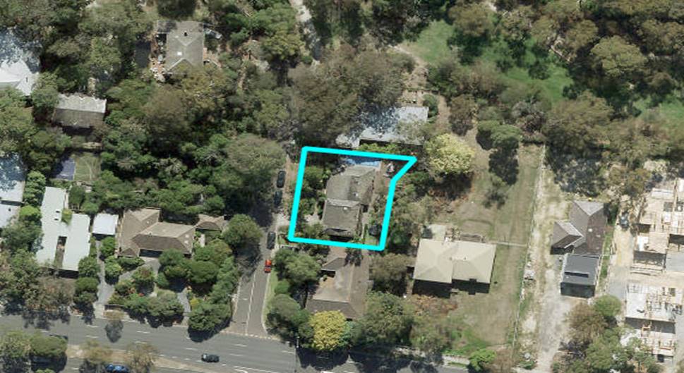
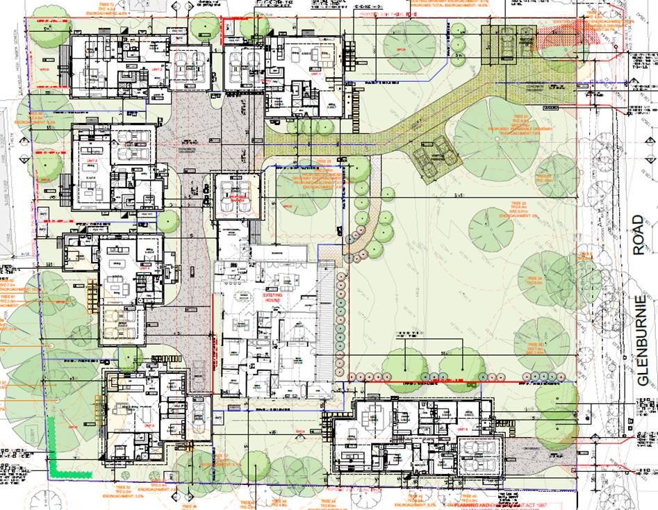
11.2 50
Glenburnie Road, MITCHAM (LOT 2 LP 37448)– Construction of four double
storey dwellings and associated tree removal
City
Planning and Development
Director City Development
FILE NUMBER: WH/2021/1191
ATTACHMENT
SUMMARY
This planning permit application proposes the
construction of four double storey dwellings, removal of protected trees and
buildings and works within 4 metres of protected trees. The application
triggers a planning permit pursuant to the provisions of the Neighbourhood
Residential Zone Schedule 1 and the Significant Landscape Overlay Schedule 7.
This application was advertised and a total of 26
objections were received. The objections raised issues with neighbourhood
character, loss of vegetation, visual bulk, amenity impacts (overlooking and
privacy), traffic impacts and stormwater management.
In response to concerns raised by Council Officers and
objectors, amended sketch plans were submitted by the applicant for discussion
purposes. These plans include the following key changes from the plans
originally advertised:
• Dwelling
2 garage relocated to the rear (west) of this dwelling, and associated redesign
of this dwelling.
• Dwellings
2 and 3 amended to provide a minimum 2 metre setback from the south boundary at
the ground level
• Provision
of a more substantial landscape break between Dwellings 2 and 3.
A Consultation Forum was held online via Zoom on 1 September 2022 chaired by Councillor Cutts. A
copy of the amended sketch plans was attached to the Forum invitations sent out
to the objectors, and these plans were discussed at the Forum. The
objectors’ concerns were explored, and the applicant offered to make some
concessions, including providing visitor car spaces on site, however no
resolution was reached between the parties at the Forum.
The application has been referred to internal
department for comments. Council’s consulting arborist has supported the
proposed removal of the trees as they are considered to either have structural
issues or provide little landscape contribution. Permit conditions are
required to minimise the construction impacts on the longevity of the remaining
trees within the site and neighbouring property, including those within the
road reserve. Council’s Asset Engineer, Transport Engineer,
Environmentally Sustainable Development Officer, and Waste Management Team have
reviewed the proposed development and are supportive subject to conditions.
This report assesses the application against the
relevant provisions of the Whitehorse Planning Scheme, including the provisions
of the Neighbourhood Residential Zone 1, Significant Landscape Overlay Schedule
7, Residential Development Policy, Tree Conservation Policy, Environmental
Sustainable Development Policy, Clause 55 (ResCode), Clause 53.18 (Stormwater
Management in Urban Development) and Clause 52.06 (Car Parking), as well as the
objector concerns.
It is recommended that the application, based on the circulated amended
sketch plans be supported, subject to conditions, in particular to include the
provision of two on-site visitor car spaces as discussed at the Forum, improve
the landscaping outcomes, remove the front fence and alter the cladding
colours.
|
MOTION
Moved by Cr Cutts, Seconded
by Cr Stennett
That Council:
Being the Responsible
Authority, having caused Application WH/2021/1191 for 50 Glenburnie Road,
MITCHAM (LOT 2 LP 37448) to be advertised and having received and noted the
objections is of the opinion that the granting of a Planning Permit for the
construction of four double storey dwellings and associated tree removal is
not acceptable and will unreasonably impact on the neighbourhood character
and the amenity of adjacent properties.
Issue a Notice of Refusal to
Grant a Permit under the Whitehorse Planning Scheme to the land described as
50 Glenburnie Road, MITCHAM (LOT 2 LP 37448) for the construction of four
double storey dwellings and associated tree removal, on the following
grounds:
The proposal is contrary to
the State Planning Policy Framework contained with the Whitehorse Planning
Scheme, particularly in relation to:
Clause 12.05-2S (Landscapes)
Clause 15 (Built Environment
and Heritage).
The proposal is contrary to
the Local Planning Policy Framework contained in the Whitehorse Planning
Scheme, particularly in relation to the following Clauses:
Clause 21.05 (Environment);
Clause 21.06 (Housing);
Clause 22.03 (Residential
Development);
Clause 22.04 (Tree
Conservation)
The proposal fails to meet
the landscape character objective and the decision guidelines of the
Significant Landscape Overlay Schedule 7. In particular, the site
layout fails to offer sufficient tall tree planting opportunities throughout
the centre of the site, and the building forms, materials, finishes and front
fencing fails to achieve an inconspicuous profile within the landscape.
The built form and building
bulk of the new dwellings are excessive, and insufficient boundary setbacks
are provided, contrary to the preferred neighbourhood character requirements
of the Bush Environment precinct guidelines and policy requirements at
Clauses 21.06 (Housing) and 22.03 (Residential Development).
The proposed development will
not adequately respect the existing and preferred neighbourhood character and
amenity of the area, failing to meet the purpose and decision guidelines of
the Neighbourhood Residential Zone.
The development fails to meet
the following Objectives and Standards of Clause 55 (including Standards as
varied by Schedule 1 to the Neighbourhood Residential Zone):
Neighbourhood Character
Site Coverage
Landscaping
Internal Views
Design Detail
The increased vehicle movements
and likely on-street car parking demand will conflict with the operation and
landscape character of Glenburnie Road.
The Motion was put to the vote and was LOST
A Division was
called.
Division
|
For
Cr Carr
Cr Cutts
Cr McNeill
Cr Stennett
|
Against
Cr Barker
Cr Davenport
Cr Lane
Cr Liu
Cr Massoud
Cr Munroe
Cr Skilbeck
|
On the results of the Division the motion was
declared lost
|
|
The
substantive motion was put to the vote and
became the Council Resolution as follows:
Council
Resolution
Moved
by Cr Munroe, Seconded by Cr Davenport
That
Council:
A Being the Responsible Authority, having
caused Application WH/2021/1191 for 50 Glenburnie Road, MITCHAM (LOT 2 LP
37448) to be advertised and having received and noted the objections is of
the opinion that the granting of a Planning Permit for the construction of
four double storey dwellings and associated tree removal is acceptable and
should not unreasonably impact the amenity of adjacent properties.
B Issue a Notice of Decision to Grant a
Permit under the Whitehorse Planning Scheme to the land described as 50
Glenburnie Road, MITCHAM (LOT 2 LP 37448) for the construction of four double
storey dwellings and associated tree removal, subject to the following
conditions:
1. Before
the development starts, or vegetation is removed, amended plans must be
submitted to and approved by the Responsible Authority in a digital
format. When approved, the plans will be endorsed and will then form
part of the permit. The plans must be drawn to scale, and be generally
in accordance with the plans submitted with the application but modified to
show:
a) A
full set of revised drawings that reflect the changes detailed in the
discussion plans dated 24 August 2022, including:
i. Dwelling
2 garage relocated to the rear (west) of this dwelling, and associated
redesign of this dwelling.
ii. Dwellings
2 and 3 amended to provide a minimum 2 metre setback from the south boundary
at the ground level
iii. Provision
of a more substantial landscape break between Dwellings 2 and 3.
b) Reinstate
the steps within Dwellings 2 and 3 ground levels, as per the advertised plans
(dated 7 April 2022) in order to limit the height of finished floor levels
above natural ground levels.
c) The
provision of two visitor car spaces on the site:
i. One visitor car space be positioned
between the garages of Dwellings 1 and 4, and the separation between these
garages increased from 3.4 to 3.5 metres to accommodate the car
space. One visitor car space to be positioned west of the
Dwelling 2 garage.
d) Visitor spaces to be paved with grasscrete
(concrete lattice with lawn growing between) or similar.
e) All
buildings and works (including soil level changes) to be set back from the
north boundary fence, so the encroachment into the 7.2 metre TPZ of Tree 25
is less than 10%.
f) All
buildings and works (including soil level changes) to be set back a minimum
of 1.6 metre from the south boundary fence, where within the 2.3 metre TPZ of
Tree 46.
g) Deletion
of the front fence.
h) Where
within the TPZ of Tree 5, the proposed driveway must be constructed at grade
(no more than 100mm in depth) and using a permeable material.
i) The
upper level internal facing highlight windows to be located 1.7 metres above
finished floor level (instead of the nominated 1.6 metres).
j) The
width of the garage door openings to be annotated on the plans.
k) The
pedestrian doors to garages to open outwards so as to not obstruct the
dedicated car parking area.
l) The accessway ramp grades to be nominated on the
plans.
m) The
provision of a fixed and durable freestanding overlooking screen above the
south boundary fence opposite the Dwelling’s 2 and 3 master
bedrooms. The screen must have a maximum of 25% openings and must
extend to a minimum height of 1.7 metres above finished floor levels of these
rooms.
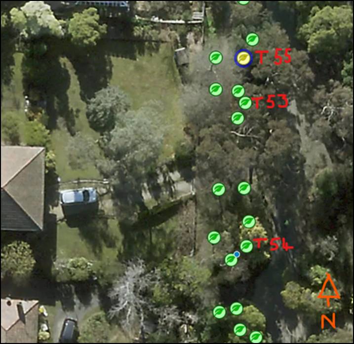
n) The plans to show the locations (refer Appendix 1)
and TPZs of the following additional trees within the road reserve:
i. Tree 53 - Corymbia
ficifolia (Flowering Gum) TPZ: 2 metre radius
ii. Tree
54 - Eucalyptus nicholii (Narrow Leafed Peppermint) TPZ: 2 metre
radius
iii. Tree
55 - Hymenosporum flavum (Native Frangipani) TPZ: 2 metre radius
o) The
cladding colours for all dwellings to utilise muted and earthy tones that
will blend in with the landscape.
p) Locations
of letter boxes and meter boxes positioned clear of the sight line triangle
shown on the plans.
q) Plans
annotated to indicate that the construction measures and tree protection
requirements specified by the Tree Protection Plan will be observed at all
times.
r) Development plans to reflect all sustainability
features indicated in the amended
Sustainable Design Assessment. Where features cannot be visually shown,
include a notes table providing details of the requirements (ie. energy and
water efficiency ratings for heating/cooling systems and plumbing fittings
and fixtures, etc)
s) Notation on site plans indicating that all obscured
glazing be manufactured obscured glass. Obscure film being applied to clear
glazing will not be accepted.
t) The landscape plan amended to show:
i. The planting of predominantly indigenous
species.
ii. The density of landscaping across the site
increased to include dense shrubs and substantial understorey plantings,
particularly within the site frontage, to ensure the site provides an appropriate
contribution to the landscape character.
iii. The use of a wide variety of species to support
biodiversity and mitigate the effects of climate conditions on individual
species.
iv. The planting of substantial bushy shrub
species adjacent to the front elevations of Dwellings 1 and 2 to mitigate the
visual impact of the elevated finished floor levels in these locations.
v. The planting of at least six additional trees
capable of reaching mature height of at least 15 metres. Total of 12
trees comprising existing and new.
vi. Canopy trees
to be located within designated garden beds.
vii. All
trees are to have a minimum height of 1.5 metres at the time of planting, and
should be planted clear of easements, a minimum 3.5 metres away from
dwellings and a minimum 1.5 metres from property boundaries.
All of the above must be to the satisfaction of the
Responsible Authority. Once approved these plans become the endorsed plans of
this permit.
2. The
layout of the site and the size, design and location of the buildings and
works permitted must always accord with the endorsed plan and must not be
altered or modified without the further written consent of the Responsible
Authority.
3. Prior
to the occupation of the approved buildings, landscaping and tree planting
must be undertaken in accordance with the endorsed landscape plan that forms
part of this permit, to the satisfaction of the Responsible Authority.
4. The
garden areas shown on the endorsed plan must only be used as gardens and must
be maintained in a proper, tidy and healthy condition to the satisfaction of
the Responsible Authority. Should any tree or shrub be removed or
destroyed it must be required to be replaced by a tree or shrub of similar
size and variety.
5. Prior
to the commencement of any site works, including demolition and excavation,
the Responsible Authority must be provided with evidence that a Project
Arborist has been engaged as part of the ongoing consultant team to oversee
all buildings and works, and to ensure the development does not have a
detrimental impact on the ongoing health and stability of the trees to be
retained. The Project Arborist must have a qualification in arboriculture and
hold a minimum Diploma in Horticulture (Arboriculture).
6. Prior
to the commencement of any buildings or works, a Tree Protection Plan (TPP)
must be submitted to and approved by the Responsible Authority. When
approved, the TPP will be endorsed and will then form part of the
permit. The TPP must be written in accordance with the requirements set
out on Page 21, under Section 5.2 Tree Protection Plan in AS4970-2009
Protection of Trees on Development Sites, and must include (but not be
limited to) the following:
a) Tree
Protection Zone Fencing Measures for all retained trees on the subject site,
surrounding lots and within the road reserve.
b) Detail
how Trees 1-14, 18, 25, 26, 29, 31-38, 41, 46 and 49 will be protected
pre-construction, during the construction stage (including landscaping) and
post construction, and must be to the satisfaction of the Responsible
Authority.
c) Detail
how excavation works within the Tree Protection Zones of Trees 1-11, 25, 37,
38 and 41 (and any other trees on the site or in the road reserve shown to be
retained on the plans) will be undertaken and how tree roots will be managed,
so that the health and stability of trees are not adversely impacted now or
into the future.
d) Detail
where services and utility connections (such as drainage and stormwater pipes
and underground electrical and telecommunication cables) will be located and
how they will be installed. These are to be located outside of the Tree
Protection Zone. If services are required to be installed within the
Tree Protection Zones of Trees 1-14, 18, 25, 26, 29, 31-38, 41, 46 and 49,
these services must be bored under the tree protection zone, or installed
using hydro excavation under the supervision of the Project Arborist.
e) Any
works to the existing vehicle crossover must be undertaken under the
supervision of the Project Arborist
f) Any tree
pruning is to conform to AS4373-2007 Pruning of Amenity Trees and the work is
to be performed by a suitably qualified arborist (AQF Level 3, minimum).
All of the above requirements for
the Tree Protection Plan must be to the satisfaction of the Responsible
Authority.
Asset
Engineering
7. All stormwater drains
and on-site detention systems are to be connected to the legal point of
discharge to the satisfaction of the Responsible Authority prior to the
occupation of the building/s. The requirement for on- site detention
will be noted on your stormwater point of discharge report, or it might be
required as part of the civil plans approval.
8. Detailed stormwater
drainage and/or civil design for the proposed development are to be prepared
by a suitably qualified civil engineer and submitted to the Responsible
Authority for approval prior to occupation of the development. Plans
and calculations are to be submitted with the application with all levels to
Australian Height Datum (AHD). All documentation is to be signed by the
qualified civil engineer.
9. Stormwater that could
adversely affect any adjacent land shall not be discharged from the subject
site onto the surface of the adjacent land.
10. Prior to works commencing the
Applicant/Owner is to submit design plans for all proposed engineering works
external to the site. The plans are to be submitted as separate
engineering drawings for assessment by the Responsible Authority.
11. The Applicant/Owner is
responsible to pay for all costs associated with reinstatement and/or
alterations to Council or other Public Authority assets as a result of the
development. The Applicant/Owner is responsible to obtain all relevant
permits and consents from Council at least 7 days prior to the commencement
of any works on the land and is to obtain prior specific written approval for
any works involving the alteration of Council or other Public Authority
assets. Adequate protection is to be provided to Council’s
infrastructure prior to works commencing and during the construction process.
12. The qualified civil engineer
when undertaking civil design must ensure that the landscape plan/s and
drainage plan/s are compatible. The stormwater drainage and on site
detention system must be located outside the tree protection zone (TPZ) of
any trees to be retained.
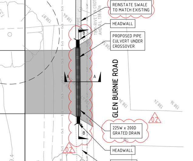
13. Any works to the vehicle crossing
must be constructed as per Council standards with a pipe, headwalls and
trench grate where the crossover traverses the swale drain along Glenburnie
Road, in accordance with the diagram in Appendix 2.
Waste Management
14. The
requirements of the endorsed Waste Management Plan (WMP) must be implemented
by the owners and occupiers of the site for the life of the dwellings, to the
satisfaction of the Responsible Authority. Any revision of the WMP or
changes to the approved waste system of the development require Council
approval.
15. Any
Mobile Garbage Bin (MGB) placements proposed on Glenburnie Road for on-street
bin collection service must not cause any obstruction to any infrastructure
or cause any danger to traffic/pedestrians. Bins are not to be placed within
1 metre of any infrastructure and are to have a height clearance of 4 metres
for collection.
16. If
the criteria for the on-street bin collection services is unable to be met
and the service is rendered inoperable, then the waste collection service
will revert to an external Private waste collection service and an amended
WMP must be resubmitted to Council for approval.
Environmentally Sustainable Development
17. Prior
to the commencement of any buildings or works, an updated Sustainable Design
Assessment (SDA) must be submitted to and approved by the Responsible
Authority. This SDA must be generally in accordance with the SDA
submitted with the application, but amended to include the following changes:
a) Reverse cycle electric heating and
cooling systems to include a minimum 4 star energy efficiency rating. Gas
heating is discouraged.
b) Hot water systems to be energy
efficient electric solar or heat pump.
c) 32 Amp power is to be supplied to the
garage of each dwelling for future EV car charging.
d) Solar photovoltaic panels with
capacity maximised for the available roof area.
Once submitted and approved to the satisfaction of the
Responsible Authority, the SDA will form part of the endorsed plans under
this permit.
The requirements of the SDA must be demonstrated on the plans
and elevations submitted for endorsement. Prior to the occupation of
the development, the development must be constructed in accordance with the
endorsed Sustainable Design Assessment to the satisfaction of the Responsible
Authority, and the approved dwellings must operate in accordance with this
document, to the satisfaction of the Responsible Authority. No
alterations to the Sustainable Design Assessment may occur without the
written consent of the Responsible Authority.
18. Before
the development starts, a Construction Management Plan to the satisfaction of
the Responsible Authority, detailing how the owner will manage the
environmental and construction issues associated with the development, must
be submitted to and approved by the Responsible Authority.
19. The
Construction Management Plan must be prepared and managed by a suitably
qualified person who is experienced in preparing Construction Management
Plans in accordance with the City of Whitehorse Construction Management Plan
Guidelines.
The Construction Management Plan must:
a) Require
all vehicles associated with the construction of the approved development to
access the subject site from the north, to minimise impacts to street trees
overhanging the Glenburnie Road reserve to the south.
Require all trees and understorey
vegetation in the road reserve to be protected from construction impacts, and
nominate locations for construction worker and construction vehicle parking
and access, and storage of construction materials on the subject land (or
elsewhere to the satisfaction of the Responsible Authority), clear of the
Tree Protection Zones of retained trees as per the Tree Protection Plan requirements. When approved, the Construction
Management Plan will be endorsed and will form part of this permit and must
be complied with, to the satisfaction of the Responsible Authority, to the
extent that this is in the control of the owner of the land. The owner of the
land is to be responsible for all costs associated with the works to be
undertaken in accordance with the requirements of the approved Construction
Management Plan.
The
provisions, recommendations and requirements of the approved Construction Management Plan must be implemented and complied
with to the satisfaction of the Responsible Authority.
20. The
development must be provided with external lighting capable of illuminating
access to each garage and car parking space. Lighting must be located,
directed and shielded and of limited intensity that no nuisance or loss of
amenity is caused to any person within and beyond the site.
21. All
treatments to prevent overlooking must not include ‘Translucent
film’ on windows and must be in accordance with Standard B22 of Clause
55.
22. This
permit will expire if one of the following circumstances applies:
a) The development
is not commenced within two (2) years from the date of issue of this permit;
b) The development
is not completed within four (4) years from the date of this permit.
The Responsible Authority may extend the periods
referred to if a request is made in writing pursuant to the provisions of
Section 69 of the Planning and Environment Act 1987.
Permit Notes:
A. The
construction or reinstatement of crossovers is to be to Council standards and
at the full cost of the permit holder.
B. The
design and construction of letterboxes is to accord with Australian Standard AS-NZ
4253-1994.
C. The
lot/unit numbers on the “Endorsed Plan” are not to be used as the
official street address of the property. All street addressing enquiries can
be made by contacting our Property Team on 9262 6470.
Asset Engineering
D. The
design and construction of the stormwater drainage system up to the point of
discharge from an allotment is to be approved by the appointed Building
Surveyor. That includes the design and construction of any required
stormwater on-site detention system. The Applicant/Owner is to submit
certification of the design of any required on-site detention system from a
registered consulting engineer (who is listed on the Engineers Australia
National Professional Engineer Register or approved equivalent) to Council as
part of the civil plans approval process.
E. The
requirement for on- site detention will be noted on your stormwater point of
discharge report, or it might be required as part of the civil plans
approval.
F. All
proposed changes to the vehicle crossing are to be constructed in accordance
with the submitted details, Whitehorse Council’s – Vehicle
Crossing General Specifications and standard drawings
G. The
Applicant/Owner is to accurately survey and identify on the design plans all
assets in public land that may be impacted by the proposed development. The
assets may include all public authority services (i.e. gas, water, sewer,
electricity, telephone, traffic signals etc.) and the location of street
trees or vegetation. If any changes are proposed to these assets then the
evidence of the approval is to be submitted to Council and all works are to
be funded by the Applicant/Owner. This includes any modifications to
the road reserve, including footpath, naturestrip and kerb and channel.
H. The
Applicant/Owner must obtain a certificate of hydraulic compliance from a
suitably qualified civil engineer to confirm that the on-site detention works
have been constructed in accordance with the approved plans, prior to
Statement of Compliance is issued.
I. There
is to be no change to the levels of the public land, including the road
reserve or other Council property as a result of the development, without the
prior approval of Council. All requirements for access for all-abilities
(Disability Discrimination Access) are to be resolved within the site and not
in public land.
J. No
fire hydrants that are servicing the property are to be placed in the road
reserve, outside the property boundary, without the approval of the Relevant
Authority. If approval obtained, the property owner is required to enter into
a S173 Agreement with Council that requires the property owner to maintain
the fire hydrant”
K. Redundant
vehicle crossing(s) must be removed at the same time as the construction of
any new vehicle crossing(s), prior to the completion of development works and
where access to a property has been altered by changes to the property.
L. Floor
levels must be amended if vehicle access to the garage cannot be achieved.
The architect and/or designer must ensure that vehicle access is to conform
to the Australian Standards for Off-Street Parking (AS/NZS 2890.1:2004)
Waste Management
M. Waste
collections for this development are to be completed externally by
Council’s waste collection contractor.
N. Council
issued bins will be required for this development.
O. Mobile
Garbage Bin usage is based on individual usage by the occupiers of the
development.
P. Every
rateable tenement is liable to pay for municipal charges irrespective of the
level of collection services provided by Council.
Q. All
aspects of the waste management system including the transfer of bins for
collection is to be the responsibility of the occupiers, caretaker, manager
and/or the body corporate – not the collection contractor.
CARRIED
|
|
A Division was
called.
Division
|
For
Cr Barker
Cr Davenport
Cr Lane
Cr Liu
Cr Massoud
Cr Munroe
Cr Skilbeck
|
Against
Cr Carr
Cr Cutts
Cr McNeill
Cr Stennett
|
On the results of the Division the motion was
declared carried
|
Appendix 1 – Locations of Trees 53-55:
Appendix 2 – Crossover construction diagram:
C Has made this decision having particular
regard to the requirements of Sections 58, 59, 60 and 61 of the Planning and
Environment Act 1987.
MELWAYS
REFERENCE 49 A12
|
Applicant: Mad
Men Developments Pty Ltd
Zoning: Neighbourhood
Residential Zone, Schedule 1
Overlays: Significant
Landscape Overlay, Schedule 7
Relevant
Clauses:
Clause
11 Settlement
Clause
12 Environment
and Landscape Values
Clause
15 Built
Environment and Heritage
Clause
16 Housing
Clause
18 Transport
Clause
21.05 Environment
Clause
21.06 Housing
Clause
22.03 Residential
Development
Clause
22.04 Tree Conservation
Clause
32.09 Neighbourhood
Residential Zone Schedule 1
Clause
42.03-2 Significant Landscape Overlay,
Schedule 7
Clause
52.06 Car Parking
Clause
53.18 Stormwater
Management in Urban Development
Clause
55 Two
or More Dwellings on a Lot or Residential Buildings
Clause
65 Decision
Guidelines
Ward: Simpson
|
BACKGROUND
History
There has been one previous Planning Permit (WH/2010/566)
issued to the subject site on 28 September 2010, allowing the removal of two
trees and lopping of one tree.
In relation to the current application, after the
advertising process, the applicant submitted amended sketch plans, dated 24 August 2022, for discussion purposes in
response to concerns raised by Council Officers and objectors. These
plans include the following key changes from the plans originally advertised:
• Dwelling
2 garage relocated to the rear (west) of this dwelling, and associated redesign
of this dwelling.
• Dwellings
2 and 3 amended to provide a minimum 2 metre setback from the south boundary at
the ground level
• Provision
of a more substantial landscape break between Dwellings 2 and 3.
The sketch plans will be discussed in this report, and
given effect through permit conditions, should Council form the view to issue a
permit..
The Site and Surrounds
The subject site is located on the west side of
Glenburnie Road, 120 metres south of the intersection with Langford
Avenue.
The site is generally rectangular in shape with a
frontage of 33.3 metres to Glenburnie Road, and a maximum boundary length of 72
metres, yielding a total site area of 2,393m2.
The site slopes by approximately 6.5 metres from the
north-west down the south-east corner of the site.
The site currently accommodates a double storey brick
dwelling with a hipped tile roof. An attached garage is located to the
front of the building. A 0.75 metre high timber fence extends across the
site’s frontage and sits behind a densely vegetated road reserve.
The surrounding area is residential in nature and
consists of an undulating topography. The natural landscape of Glenburnie
Road and the adjacent streets contain remnant indigenous and native trees and
understorey vegetation. The tree canopy encloses the space and creates
the impression of homes being sited within the landscape rather than trees
being planted around homes. Buildings are a mix of styles with few
front fences interrupting the overall bush landscape.
The era and style of dwellings along Glenburnie Road
is varied, and the street contains a mixture of single and double storey
weatherboard, brick, and render dwellings, with hipped or gable style roof
forms constructed of either concrete tiles or corrugated steel. Feature
gables that present to the street are frequent features.
Double storey dwellings are also common, and large
upper-level components are found on several of the properties within the
immediate surrounding area (including the existing dwelling on the subject
site). Double storey sheer walls are also present on several of the nearby
properties.
Within the immediate context, the following is
observed:
North
· The adjoining lot to the north, at 42-48 Glenburnie
Road, contains a dwelling and outbuilding, protected by Heritage Overlay,
Schedule 296 on a lot 4,800m2 in size. The heritage dwelling
is known as Minamere.
· Planning permit WH/2018/45 was issued at the direction
of VCAT (Golden Oak Mitcham P/L v Whitehorse CC) allowing the construction
of six additional dwellings (total of seven dwellings) on this lot, and
associated vegetation removal, as shown on the snip below from the ground floor
endorsed plans.
· The development permitted under this permit is
currently under construction and includes two new single storey dwellings in
proximity to the common boundary, with Dwelling 6 (at the front of the site
near the common boundary) setback 10 metres from Glenburnie Road and between
1.3 and 1.9 metres from the boundary with the subject site. Dwelling 5 is
located towards the rear of the site near the common boundary, and is setback
between 2.7 and 5.7 metres from the common boundary.
South
· The adjoining lot to the south, at 52 Glenburnie Road,
contains a single storey dwelling. The dwelling is setback approximately
17 metres from Glenburnie Road and 3.5 metres from the common boundary.
· Vehicle access is via a crossover and driveway
adjacent to the lot’s north boundary with a number of outbuildings
located adjacent to the common boundary and within the rear yard.
West
· Two lots adjoin the subject site to the west.
· The lot at 29 Halls Parade contains a large, single
storey dwelling setback approximately 14 metres from the common boundary.
· The lot at 31 Halls Parade contains three
dwellings. The rear dwelling is setback approximately 3 metres from the
common boundary.
Planning Controls
Neighbourhood Residential Zone, Schedule 1
In accordance with Clause
32.09-6 of the Neighbourhood Residential Zone, a permit is required for the
construction of two or more dwellings.
Clause 55 applies to ‘Two or more dwellings on a
lot and residential buildings’. Schedule 1 to the Neighbourhood
Residential Zone includes variations to the requirements of Clause 55.
This includes variations to B8 (Site coverage), B9 (Permeability), B13
(Landscaping), B17 (Side and rear setbacks), B18 (Walls on boundaries),
Standard B28 (Private Open Space) and B32 (Front fences) of Clause 55.
Under Clause 32.09-4 a development must meet a minimum
garden requirement of 35%. The development plans indicate a compliant
garden area of 1218m2 or 50.8%.
Under Clause 32.09-10, the building height must not
exceed 9 metres and the building must contain no more than 2 storeys at any
point. A building may exceed the maximum building height by up to 1 metre
if the slope of the natural ground level, measured at any cross section of the
site of the building wider than 8 metres, is greater than 2.5 degrees.
Although the slope of the site would allow a 10 metre
building height, the proposed dwellings are all two storey and have a maximum
height of 9 metres, in compliance with this requirement.
Significant Landscape Overlay, Schedule 7
Pursuant to Clause 42.03-2 a permit is required for:
· The removal of a tree having a single trunk
circumference of 0.5 metre or less at a height of one metres above ground
level.
A summary of the trees on the subject site that
require a planning permit to be removed under the SLO7 follows:
Table 1 – Trees requiring a permit to be removed under the SLO7
|
Tree
No.
|
Species
|
DBH
(cm)
|
Height
(m)
|
Condition
|
|
17
|
Eucalyptus camaldulensis – River Red Gum
|
63
|
12
|
Medium Retention Value
|
|
20
|
Syzygium smithii – Lilly Pilly
|
23
|
6
|
Low Retention Value
|
|
21
|
Pittosporum eugenioides – Tarata
|
30
|
6
|
Low Retention Value
|
|
22
|
Prunus shirotae – Flowering Chery
|
17
|
6
|
Low Retention Value
|
|
23
|
Camellia japonica - Japanese camellia)
|
24
|
4
|
Medium Retention Value
|
|
24
|
Ilex aquifolium – Holly
|
17
|
3
|
Low Retention Value
|
|
28
|
Loptospermum lanigerum – Woolly Teatree
|
20
|
4
|
Low Retention Value
|
|
39
|
Group of 3 trees- Callistemon, Cotoneaster,
Melaleuca squamosa
|
21
|
5
|
Low Retention Value
|
|
44
|
Pyrus communis – Common pear
|
25
|
4
|
Low Retention
Value
|
|
45
|
Ficus carica
– Edible fig
|
34
|
3
|
Low Retention Value
|
|
47
|
Citris x paradisi - Grapefruit
|
17
|
2
|
Low Retention Value
|
|
48
|
Pyrus communis – Common pear
|
21
|
5
|
Low Retention Value
|
|
52
|
Magnolia x soulangeana – Saucer magnolia
|
17
|
4
|
Low Retention Value
|
• Note
1: D.B.H = Trunk Diameter at Breast Height. A 16cm DBH = 0.5 metre trunk
circumference)
• Note
2: Tree No. 50 is a Tree Fern, not a tree, and so is not considered to be
protected under the SLO7.
• Note 3: The following
trees on the subject site do not trigger the requirement for a permit for
removal under SLO7 as they have a single trunk circumference of 0.5 metre or
less at a height of one metre above ground level: Trees 15, 16, 19, 27, 30, 40
and 51.
Table 2 – Proposed
buildings and works within four metres of protected trees
|
Tree No.
|
Species
|
DBH (m)
|
Height (m)
|
Location
|
TPZ encroach -ment
|
|
1
|
Eucalyptus goniocalyx - Long-leaved Box
|
50
|
11
|
Road reserve
|
<10%
|
|
9
|
Quercus palustris - Pin Oak
|
32
|
11
|
Road reserve
|
>10%
|
|
10
|
Quercus palustris - Pin Oak
|
33
|
10
|
Road reserve
|
>10%
|
|
12
|
Cinnamomum camphora – Camphor Laurel
|
33
|
9
|
52 Glenburnie Rd, frontage
|
0%
|
|
13
|
Syzygium smithii – Lilly Pilly
|
18
|
7
|
Subject site, front south boundary
|
0%
|
|
14
|
Liquidambar styraciflua – American sweet gum
|
42
|
12
|
52 Glenburnie Rd, frontage
|
9%
|
|
18
|
Abies alba
– Silver fir
|
36
|
9
|
Subject site, centre frontage
|
6.4%
|
|
25
|
Agonis flexuosa – Willow myrtle
|
60
|
8
|
42-48 Glenburnie Rd
|
12.6%
|
|
26
|
Pittosporum eugenioides - Tarata
|
32
|
7
|
42-48 Glenburnie Rd
|
0%
|
|
29
|
Cotinus spp.
– Smoke bush
|
18
|
5
|
42-48 Glenburnie Rd
|
0%
|
|
31
|
Banksia marginata – Silver banksia
|
42
|
6
|
42-48 Glenburnie Rd
|
4.5%
|
|
Tree No.
|
Species
|
DBH (m)
|
Height (m)
|
Location
|
TPZ encroach -ment
|
|
32
|
X 2 Photinia serratifolia – Chinese Hawthorn
|
26
|
6
|
42-48 Glenburnie Rd
|
0%
|
|
33
|
Eucalyptus polyanthemos – Red Box
|
53
|
11
|
42-48 Glenburnie Rd
|
0.6%
|
|
34
|
Pittosporum undulatum – Sweet pittosporum
|
30
|
7
|
42-48 Glenburnie Rd
|
0%
|
|
35
|
Acer negundo
– Box Elder
|
25
|
7
|
42-48 Glenburnie Rd
|
0%
|
|
36
|
Quercus palustris – Pin Oak
|
58
|
13
|
29 Halls Pde
|
0%
|
|
37
|
Fraxinus excelsior – Golden Ash
|
41
|
8
|
Subject site, rear boundary
|
5.7%
|
|
38
|
Grevillea robusta – Silky Oak
|
39
|
13
|
Subject site, rear boundary
|
1.6%
|
|
41
|
Thuja orientalis – Oriental thuja
|
50
|
8
|
3/31 Halls Pde
|
9.5%
|
|
42
|
Cinnamomum camphora - Camphor laurel
|
16
|
4
|
3/31 Halls Pde
|
0%
|
|
46
|
Acer rubrum cv. – Red maple cultivar
|
19
|
8
|
52 Glenburnie Rd, rear
|
16%
|
|
49
|
2 x Pittosporum undulatum – Sweet pittosporum
|
24
|
7
|
52 Glenburnie Rd, rear
|
2.1%
|
• Note: D.B.H = Trunk Diameter
at Breast Height. A 16cm DBH = 0.5 metre trunk circumference)
Schedule 7 to the Significant Landscape Overlay sets out a number of
‘permit triggers’ for buildings and works. These
‘trigger’ requirements are not mandatory, rather they require a permit
application to allow consideration of the merits of the proposal.
The building (roofed area) coverage, hard surface (comprising driveway,
paths, constructed landings and water tanks) coverage and permeable area
figures differ slightly from the circulated sketch plans, as they are based on
calculations undertaken by Council Officers.
Table 3 – Proposed
SLO7 Permit Triggers for Buildings and Works
A permit
is not required to construct a building or construct or carry out works
provided all of the following are met:
|
Permit requirement
|
Measure
|
|
|
|
The total area covered by buildings does
not exceed 35% of the site area.
|
The building site coverage is 37.16%
Permit triggered
|
|
The works, comprising hard surfaced and
impervious areas (including tennis courts and swimming pool, but excluding
buildings) are less than 15 per cent of the site area.
|
There is no declaration of hard surfaces however the hard paved
surfaces have been calculated by officers at 14.5%
No permit trigger
|
|
The buildings or works are setback more than 4 metres from any tree
for which a permit is required to remove, destroy or lop under the provisions
of this schedule.
|
The buildings and works occur within 4 metres of trees
1, 9, 10, 12, 13, 14, 18, 25, 26, 29, 31-38, 41, 42, 46 and
49
Permit triggered (refer to table 2 above)
|
PROPOSAL
The application proposes the construction of four
double storey dwellings. The dwellings are detached, with Dwellings 1 and
2 fronting Glenburnie Road with Dwellings 3 and 4 positioned towards the
rear. The key features of the proposal include:
· The dwellings are accessed via a centrally located
driveway, which offers vehicle access to all dwellings, each of which are
provided with a double-width garage.
· Dwellings 1 and 2 propose front setbacks of 10.1 and
10.5 metres respectively.
· Side setbacks vary between 1.2 and 4.7 metres and rear
setbacks vary between 10.4 and 12.5 metres.
· The dwellings each provide for an open plan kitchen,
meals and family room, formal living area, guest bedroom suite and laundry at
ground level, and master bedroom suite, two further bedrooms, leisure room and
bathrooms at upper level.
· External materials include white painted weatherboard
cladding to ground and upper level (Dulux Lexicon Quarter), Colorbond cladding
(Monument – dark grey), and feature stone cladding to verandah supports.
· Overall building heights vary between 7.2 and 9
metres.
· No alteration to the existing crossover.
· A 1 metre high white masonry pier and black metal
picket front fence.
· A building (roofed areas) coverage of 37.16%.
· A hard surface coverage (including driveway, paths,
landings and water tanks) of 14.5%
· A site permeability of 48.7%.
· A Garden Area of 50.8%.
· Removal of 13 numbered protected trees (refer to Table
1). As ‘Tree 39’ is a group of three trees, this equates to
the removal of a total of 15 actual trees.
· Retention of four trees on the subject site (refer to
Table 2).
· Buildings and works within 4 metres of 22 numbered
protected trees, which is 24 actual trees, as this list includes two pairs of
trees grouped under the one Tree number (refer to Table 2).
CONSULTATION
Public
Notice
The application
was advertised by mail to the adjacent and nearby property owners and occupiers
and by erecting notices to the Glenburnie Road frontage. Following the
advertising period 26 objections were received.
The issues raised are
summarised as follows:
· Amenity impacts:
o Overlooking
o Overshadowing
· Neighbourhood Character:
o Not in keeping with the unique bushland character of the
street
o Excessive building bulk and insufficient setbacks.
o White coloured cladding and front fence are out of keeping with
the environment
o Negative cumulative impact of recent development in the area
· Car parking and traffic:
o No on-site visitor parking provided, and restricted on-street
parking available
o The unmade landscaped verges, which are Common Ground managed
by the Residents Association and Council, will experience more pressure to be
converted into on-street parking. Common Ground landscaped paths are
unmade and most pedestrians use the roadway
o Increased traffic through surrounding streets.
· Landscaping:
o Excessive tree removal and loss of habitat. Some trees,
such as Tree 17, could be retained
o Construction impacts to retained trees.
o Insufficient open space areas for landscaping and tall trees
o Planted trees may not be maintained in the long term
· Not in keeping with the Planning
provisions
· Non-planning matters:
o Set an undesirable precedent
o Surface water runoff must be captured in drains to prevent
increased flooding to lower lots on the east side of Glenburnie Road
o Construction impacts on the street, parking, traffic flow and
security.
o Large construction vehicles could damage overhanging street
trees
o Loss of views
o Loss of sense of community
o Physical and mental health impacts to surrounding residents
In response to Council and objector concerns, the
applicant submitted the amended sketch plans referenced above. These
sketch plans were circulated to all submitters prior to the Forum for
discussion purposes.
Consultation Forum
A Consultation Forum was held via Zoom on 1 September
2022, chaired by Cr Cutts. Eight objectors, the applicant’s
planning consultant and two planning officers attended the meeting.
At the Forum, the circulated amended sketch plans were
discussed and the objectors expanded on the concerns raised in the objections
received. Additional points raised included:
· On-street car parking on Glenburnie Road is very
limited, as a result of the landscaping of the common property verges.
The additional visitor car parking demand generated by the proposed 4 dwellings
cannot be accommodated on the site and there are limited on-street parking
opportunities for visitors.
· Increased traffic on Glenburnie Road, which is largely
a single lane wide.
· Landscaping species should all be indigenous.
The applicant offered to provide on-site visitor
parking in response to these discussions, however overall no resolution of the
issues raised was reached at the Forum.
Referrals
External
No external referrals were required
Internal
Transport Engineer
Clause 52.06 of the Whitehorse Planning Scheme
requires the following parking provision for the proposed development:
|
Land Use
|
No.
|
Statutory Parking Rate
|
Required Spaces
|
|
Dwellings
|
|
|
|
|
· 4 bedroom
|
4
|
2 spaces per dwelling
|
8
|
|
· Visitor parking
|
0
|
1 space per 5 dwellings
|
0
|
|
|
|
Total Parking Requirement
|
8
|
The submitted documentation indicates that eight
resident car spaces are proposed to be provided on the site within the garages.
The proposed parking provision is therefore sufficient against the Clause 52.06
requirements.
While no on-site visitor car parking is required for
this development, it is noted that on-street car parking opportunities in
Glenburnie Road are limited due to the nature of this road, which also does not
have constructed kerb and channel requiring vehicles to park either fully or
partially on the grassed verge.
The expected level of traffic generated by the
proposal can be accommodated by Glenburnie Road and in the surrounding local
road network.
The vehicle access arrangements to and from all four
garages has been checked using a manual turning template and is considered
satisfactory.
Minimum internal garage dimensions are met.
Doors opening into the garage must not open into the clear internal minimum
dimensions.
The proposed ramp grades and dimensions must be
provided in accordance with Design standard 3 of Clause 52.06-9 of the
Whitehorse Planning Scheme. It is noted that no ramp grades have been
denoted on the plans.
Waste Engineer
The application has been reviewed by Council’s
Waste Management Team. The Waste Management Plan is approved subject to
standard conditions and notes included within the permit.
Assets Engineer
The application has been reviewed by Council’s
Asset Engineer. The application is supported subject to standard
conditions and notes included within the permit.
Concern was raised regarding the alignment of the
existing crossover (which is proposed to be retained) as it is not
perpendicular to the road reserve, and recommendations for the
construction/reconstruction of this crossover were included, as the unmade road
reserve requires the provision of headwalls, a pipe and trench grate where the
crossover traverses the swale drain along Glenburnie Road.
Planning
Arborist
The application
has been reviewed by Council’s arborist. The following is a summary
of advice:
· The plans must be amended to show the
following:
o All buildings and works (including soil level changes) must be
set back from the north boundary fence, so the encroachment into the 7.2m TPZ
of tree 25 is less than 10%.
o All buildings and works (including soil level changes) must be
set back 1.6m from the south boundary fence, where within the 2.3m TPZ of Tree
46.
· No objection to the removal of the
trees. Generally they all have low retention value.
· Tree 17 is a large River Red Gum,
however it is not worthy of retention as it is unstable at ground level.
· Based on the levels of encroachment
(listed in Table 2 above), the proposal can be supported subject to
conditions.
Parks &
Natural Environment Arborist
· Excavation for the proposed fence
within the TPZ of Trees 9 and 10 must be limited to that of the brick
piers/posts and must be conducted by hand. If large structural roots are
encountered the posts must be moved.
· Any excavation within the TPZ of Trees
2, 5, 9 and 10 must be conducted under the supervision of a minimum AQF Level 5
(or higher) qualified arborist.
· Any works to the crossover must be
under arboricultural supervision (minimum AQF Level 5).
· The proposed driveway must be
constructed at grade (100mm in depth) using a permeable material within the TPZ
of Tree 5.
· Three more juvenile trees in the road
reserve must be added to the plans and protected during construction.
These are:
o Tree 53 - Corymbia ficifolia (Flowering Gum) TPZ: 2
metres
o Tree 54 - Eucalyptus nicholii (Narrow Leafed
Peppermint) TPZ: 2 metres
o Tree 55 - Hymenosporum flavum (Native Frangipani)
TPZ: 2 metres
The locations of these trees are shown
in Appendix 1 to the permit notes (above).
ESD Advisor
The application has been reviewed by Council’s ESD
Officer. The application is supported subject to conditions.
DISCUSSION
Consistency
with State and Local Planning Policies
The central
issue surrounding this application focuses on whether the proposal successfully
resolves the tension between state planning policy, which seeks consolidation
within existing urban boundaries with that of local policies which seeks
minimal change in a landscape setting.
The relevant
State planning policies include:
· The strategic intent of the Planning
Policy Framework (PPF) is to encourage infill development that responds
appropriately to the context and character of the neighbourhood. Clause
11.01-1S (Settlement) directs infill development to areas that are well
serviced, close to activity centres and along existing transport routes.
The site enjoys physical and strategic attributes,
which make it suitable for some form of small-scale infill development.
The site is a large lot located a short distance north of Canterbury Road which
supports various bus routes with other infrastructure including local
neighbourhood activity centre (intersection of Boronia Road and Canterbury
Road), Vermont Primary School and Vermont Reserve playground. Therefore,
the development responds to Clause 11.01-1S and the concept of the ‘20
minute neighbourhood’ sought in Clause 15.01-4R (Healthy neighbourhoods
– Metropolitan Melbourne).
· The PPF contains objectives to encourage development
of well-designed medium density development that respects neighbourhood
character, improves housing choice, makes better use of existing infrastructure
and improves energy efficiency of housing. The PPF also recognises the
importance of protecting biodiversity and enhancing significant landscapes in
Clause 12.05-1S. These are discussed in further detail below.
The relevant local planning policies include:
· The Strategic Framework Plan at Clause 21.04
(Strategic Directions) identifies the site within a ‘Significant
Landscape Area’. Clause 21.05 (Environment) contains strategies to
protect the special environmental significance of areas such as the Glenburnie
Road and Environs, and includes a policy that lot sizes in Bush Environment
areas are generally in accordance with 650m2.
· Clause 21.06 (Housing) is informed by Council’s Housing
Strategy, 2014, and identifies three categories of housing change within
the City of Whitehorse. The subject site is located within a
‘Limited Change Area’. Limited Change Areas are to conserve
and enhance those elements which contribute to the valued environmental,
heritage and neighbourhood character of the place.
· Clause 22.03 (Residential Development) reiterates the
above policies and strategies and specifies the built form, landscape and
neighbourhood character outcomes sought for the various character precincts.
Clause 22.03-4 (Categories of Housing Change) contains strategies for Limited
Change Areas which ensure the scale, form and character is to be consistent
with the surrounding area and predominately comprise detached houses and
semi-detached houses.
· Clause 22.04 (Tree Conservation) applies to all
development and includes objectives for ensuring that new development minimises
the loss of significant trees and promotes the regeneration of tall trees
through the provision of adequate open space and landscaping areas in new
development.
The zone, local planning policies and the SLO7 do not
prevent change in this area, rather seek to moderate the extent of development
to respond to the specific landscape significance of the Glenburnie Road
area. Upon assessment of the above provisions, the key issues to assess
within this application include:
· Is the proposal an appropriate response to the
preferred neighbourhood character?
· Does the proposal provide a positive response to the
Significant Landscape Overlay Schedule 7?
· Does the proposal appropriately provide for sufficient
on-site car parking and traffic movements?
These key questions are addressed below.
Design and Built Form
The subject site forms part of the Glenburnie Road and
Environs Area which is an atypical suburban area given its Bush Environment
character. The City of Whitehorse Neighbourhood Character Study,
2014 summarises the existing architectural style in the area, as
‘mixed, and includes pre-WWII (including heritage significant bungalow
dwellings), post-war, 1940s, 1950s and contemporary infill styles. In terms
of the landscape setting, ‘Gardens are bushy and informal with
predominantly native/indigenous species and large canopy trees. The appearance
of vegetated garden areas around buildings is an important feature of this
precinct’.
There are a number two storey dwellings in
the vicinity of the subject site, including 43, 45, 47, 57A, 64A, 66, and 70
Glenburnie Road. Examples of multi-dwelling development sites exist
within Glenburnie Road, including the development to the north and 49
Glenburnie Road. Another nearby development is 31 Halls Parade to the
immediate west.
The Neighbourhood Character objectives of ResCode
(Clause 55.02-1) () seek to ‘ensure that the design respects the
existing neighbourhood character or contributes to a preferred neighbourhood
character’. The Design detail objectives (Clause 55.06-1)()
also encourage design details to respect the existing and preferred
character. Achieving a preferred character is also assisted by the
‘Preferred Character Statement’ outlined within Clause 22.03-5. The
Statement for Bush Environment
Precinct areas is as follows:
· The streetscapes will be dominated by vegetation with
subservient buildings frequently hidden from view behind vegetation and tall
trees. The buildings will nestle into the topography of the landscape and be
surrounded by bush-like native and indigenous gardens, including large
indigenous trees in the private and public domains.
Buildings and hard surfaces will occupy a very low
proportion of the site. They will be sited to reflect the prevailing front,
rear and side setbacks. The larger rear setbacks will accommodate substantial
vegetation including large canopy trees. The bushy environs are complemented by
street trees and a lack of front fencing. Properties abutting and close to
creeks and lake environs will contain more indigenous trees and shrubs that act
in part as wildlife corridors.
This precinct is identified for the lowest scale of
intended residential growth in Whitehorse (Limited Change area) and the
preservation of its significant landscape character and environmental integrity
is the highest priority.
The Bush Environment Precinct is at the top of the
neighbourhood character hierarchy and has been specifically targeted for the
protection and enhancement of its special environmental and landscape
characteristics. This area has been identified as suitable for the least
degree of change. The Bush Environment Precinct Guidelines provide
a number of design techniques to assist with achieving this preferred character
outcome. This includes guidance on retaining established mature trees, and
creating a spacious setting through side, rear and internal separation.
The starting point for the layout is to ensure the
significant trees are adequately protected and ample spacing around the
dwellings is provided to create a generous garden setting. The applicant’s arborist report
identifies Trees 37 (Fraxinus excelsior – Golden Ash) and 38 (Grevillea
robusta – Silky Oak) as the only ‘high’ retention trees
on site, both of which are to be retained. The ‘medium’
retention trees on site are Trees 17 (Eucalyptus camaldulensis –
River Red Gum), 18 (Abies alba – Silver fir) and 23 (Camellia
japonica – Japanese camellia). Tree 18 is retained and Trees 17
and 23 are proposed to be removed, and their removal is supported by
Council’s Arborist who has noted that Tree 17 is unstable at the
base.
The site layout provides for the
retention of the high and medium value trees appropriate for retention (based
on arboricultural advice) and with available
permeable garden area (48.7%), there
is space for new trees to be planted, which, with the available space, would
create a generous garden setting for new trees to establish within. The
SLO7 triggers consideration of site coverage where the building coverage
exceeds 35% and the hard surfaces exceed 15%, indicating that a combined
building and hard surface coverage of up to 50% is allowed as-of-right.
The proposed 51.3% only slightly exceeds this figure, and allow for a
substantial proportion of the lot to accommodate landscaping and trees.
The proposal relies on the
retention of the existing single crossover to service all dwellings on
site. This outcome minimises the loss of front garden space and minimises
the disturbance to the significant bushy vegetation within the road
reserve. Trees 1 – 11 and 53-55 within the road reserve will be
retained and as there is significant opportunity within the front setback for
further tree planting and landscaping (in addition to the retention of Tree
18), the dwellings will be able to be screened by landscaping within the site
frontage. As a result, views of the dwellings will be subservient to
vegetation.
The ‘key existing characteristics’ for Bush Environment areas
under the City of Whitehorse Neighbourhood study finds established
setbacks varying between ‘6-8 from the frontage, 1 – 3 metres
from the side with rear setbacks varying between 7 – 20 metres. New
and infill developments usually have reduced setbacks’. The
development proposes front setbacks of over 10 metres, side setbacks that vary
between 1.2 and 4.7 metres and rear setbacks that vary between 10 and 12
metres. This layout will maintain the existing
‘backyardscape’ and provides significant opportunities for
landscaping and tall tree planting with the front setback. As such, the
siting of the proposed dwellings are respectful to the existing siting pattern
within the Bush Environment setting, and allow for the retention of the
existing trees with space for new dwellings.
As a means of ‘maintaining and reinforcing the rhythm of spacing
between and around buildings and the alignment of buildings along the
street’, the Precinct Guidelines encourage dwellings to provide a
separation of 3-4 metres within the site and discourage boundary wall
development. Dwellings 1 and 4 provide a ground level separation of 3.4
metres and Dwellings 2 and 3 provide a ground level separation of 5
metres.
The
9 metre maximum overall building height is below the 10 metre building height
allowed under the zone for a sloping site. The proposed dwellings include
pitched roofs, with the central ridgelines only reaching the 9 metre maximum
height, and the balance of the proposed dwellings substantially lower, as the
dwellings step down with the slope of the land. The proposal does not present a
significant height difference to the neighbouring dwellings and other
double-storey developments within the local setting.
The
proposed dwelling façades are well-articulated, including recessed upper
levels, and staggered setbacks across the built form, decorative verandahs,
hipped roof forms (with eaves) at ground and upper level, and variation in
materials. This prevents visual monotony and visual intrusion within the
development and softens the perception of building bulk to the adjoining
lots.
The
use of weatherboard cladding provides fine grain detailing to the building
forms and reflects the character of older style dwellings in the vicinity,
including the heritage protected Minamere to the north. However
the stark white walls and dark grey coloured roofs proposed will be visually
intrusive within the Bush Environment Character, and the use of more muted and
earthy toned cladding materials will be required as a condition of approval to
ensure the dwellings retain an inconspicuous profile and blend with the
landscape (a SLO7 objective).
The
site includes a substantial slope upwards from the street, and in the
originally advertised plans, all of the proposed dwellings have stepped ground
floor levels to keep the finished floor levels as close as possible to the
sloping natural ground levels. It is noted that steps within Dwellings 2
and 3 ground levels have been removed in the amended sketch plans, and a
condition will require these to be reinstated.
However, even with the stepped ground
floor levels, the front facades of Dwellings 1 and 2 present relatively high
finished floor levels in relation to the natural ground levels, which are at
their lowest point in relation to the dwellings at their frontages. In
order to screen the high foundations of Dwellings 1 and 2 presenting to
Glenburnie Road, the landscape plan must be amended to require the planting of
substantial bushy shrub species adjacent to the front elevations of Dwellings 1
and 2 to mitigate the visual impact of the elevated finished floor levels in
this location.
The application proposes a front fence
comprising black steel pickets with light grey masonry plinths and on a masonry
base. The height of this fence varies with the slope of the land, being
generally around 1.2 metres high, but up to 1.7 metres high at the lowest
south-east corner.
Council’s Parks & Natural
Environment Arborist has indicated that the proposed fence will be a major
encroachment to Trees 9 and 10 in the road reserve. Furthermore, the
proposed fence height and style are out of keeping with the Landscape Character
Objectives of the SLO7 and the Bush Environment character statement, where the
use of vegetation is encouraged as an alternative to front fencing, and the
presence of a fence will detract from the bushy landscape character which is
preferred in the Glenburnie Road precinct. A condition will therefore
require that the proposed front fence is removed, to allow for the new
landscape plantings within the front setback to flow uninterrupted to the road
reserve.
Clause 21.05 Environment requires lot sizes in the area affected by the Significant
Landscape Overlay in Bush Environment character precincts to be generally in
accordance with the prevailing minimum lot size of 650m2. In
addition, the Bush Environment Precinct Guidelines also encourage subdivision
areas to be a minimum of 650m2 as a means of achieving the objective
of ‘ensuring the spacing and density of dwellings is managed to accord
with housing objectives’. Whilst these are not mandatory requirements,
the Planning Scheme includes ‘housing objectives’ and states that
areas of ‘limited change’ will undergo development in the form of
renovations to existing dwellings, replacement dwellings and some limited
medium density development. The proposal provides a density of 1:598m2
which is slightly less than the preferred density under the SLO7, but it is
considered that the proposed site layout achieves a suitable design response,
as the proposed dwellings can achieve the siting, design and landscape
objectives outlined within the SLO7 and the Bush Environment Precinct.
Subject to the changes discussed above,
the proposed development is considered to achieve a satisfactory response to
the existing and preferred character of the Bush Environment Precinct.
Landscape Assessment
The subject site is included within the Significant
Landscape Overlay Schedule 7 (Glenburnie Road and Environs). The area is
recognised as:
· The natural landscape of the southern end of
Glenburnie Road and the adjacent streets and properties is predominately dense
remnant indigenous and native trees and understorey vegetation. The tree canopy
encloses the space and creates the impression of homes being sited within the
landscape rather than trees being planted around homes. Buildings are a mix of
styles with few front fences interrupting the overall bush landscape.
Glenburnie Road, Grove and Grey Streets are sealed but narrow, with no
footpaths or kerbs. The street verges are covered by shrubs and trees creating
an informal streetscape. In Glenburnie Road, the essentially single lane width
of the street, undulating land and impaired lines of sight have a traffic
calming effect and create a pedestrian friendly environment.
The landscape objectives can be summarised as retaining
the dominance of vegetation coverage, ensuring a reasonable proportion of the
lot is free of buildings and encouraging the use of vegetation as an
alternative to front fencing. The Decision Guidelines for the SLO7
require consideration of the potential to achieve an average tree density of
one tree with a mature height of over 15 metres per 200m2 of site
area. For the 2393m2 subject site, this effectively requires
12 trees over 15 metres.
The proposed landscape plan includes the planting of 3
trees with mature heights of 20 metres, and 4 trees with mature heights of 10
metres. The proposal also includes the retention of Trees 13, 18, 23, 37,
38 and 43 on the subject site. None of these trees currently achieves a
15 metre height, but it is anticipated that Trees 13 (Lilly Pilly), 18 (Silver
Fir), and 38 (Silky Oak) all have the potential to reach mature heights of 15
metres.
Therefore, at least six further tall (15 metre) trees
are required to be planted on the subject site, and the submitted landscape
plan requires amending (via conditions) to ensure the tall tree coverage on the
subject site meets the SLO7 requirements. These must include at least one
tree located within each of the secluded private open space areas of Dwellings
1 and 2. In addition, one small tree must be planted between Dwellings 3
and 4 where it will provide a visible landscape separation between these two
dwellings when viewed at the end of the central accessway from Glenburnie
Road. The proposed site layout provides sufficient space around and
between the dwellings to support the required tall trees.
In addition, the proposed landscape plan includes a
limited range of species, many of which are not indigenous, and also provide
for limited under storey plantings. In order to achieve a landscape
response reflective of the preferred and prevailing SLO7 character of
Glenburnie Road, further amendments will be required to the landscape plan
requiring the planting of predominantly indigenous species, including dense
shrubs and understorey plantings, particularly within the site frontage to
ensure the site provides an appropriate contribution to the landscape
character.
Subject to the improved landscaping response, the site
layout, with its deep front setback will ensure the proposed double storey
dwellings maintain an inconspicuous profile, which will be further assisted by
the retention of vegetation within the road reserve.
Further protection of vegetation in the road reserve
will be achieved by requiring all construction vehicles to access the site from
the north, traversing the shortest possible length of Glenburnie Road and
thereby limiting the potential for such large vehicles to damage the
overhanging tree canopies within the Glenburnie Road reserve.
No change to the existing crossover alignment is
proposed, however if the existing crossover requires repair as a result of the
construction processes, conditions will require any crossover works to be
compliant with Council’s Asset Engineering requirements. The site will
also be required to adhere to a Construction Management Plan to ensure the site
is appropriately controlled through the construction.
Subject to the conditions from Council’s
Planning Arborist, the proposed development will have no unreasonable impacts
to the trees to be retained (on the subject site and within adjoining lots), in
keeping with the requirements of the SLO7.
The total site coverage 37.16% (discussion plans)
slightly exceeds the permit trigger of 35% (by 2.16%). The proposed site
coverage and available permeable garden area (48.7%) ensures adequate space is
retained for tree retention and planting as well as useable space for
recreation by residents of the dwellings.
The development of four dwellings provides a positive
response to the objectives and decision guidelines contained within Schedule 7
to the Significant Landscape Overlay.
Amenity
Overshadowing
The shadow diagrams submitted with the
application demonstrate that the proposal presents very little impact to
adjoining areas of secluded private open space. The shadows are largely
contained within the subject site throughout the day with small sections of
shadow cast over the adjoining carport and outbuildings (not SPOS) within the
adjoining lot to the south. With increased setbacks to the south boundary
(sketch plans), this will further reduce the impact to the south.
There is are generally no overshadowing
impacts to the adjoining lots to the west.
Overlooking
Overlooking is
generally compliant with Standard B22 (Overlooking). The following is noted:
· It is recommended a trellis be located on the south
fence where opposite the Dwellings 2 and 3 master bedrooms (addressed via a
condition of the permit).
· The upper level north-facing windows to Dwelling 1 do
not require screening as they are directly adjacent to a single storey dwelling
(Unit 6) within the approved development to the north (views are across a roof
with no impact to secluded private open space).
· The upper level north facing windows to Dwelling 4 and
the upper level south facing windows to Dwellings 2 and 3 are treated to
prevent overlooking in accordance with Standard B22.
· The ground and upper level west-facing windows to
Dwellings 3 and 4 are setback greater than 9 metres from the boundary,
therefore do not require any screening.
· The upper level internal facing windows will be
required to be screened to prevent internal views (addressed via a condition of
the permit).
Side and Rear Setbacks
The sketch plans show the ground levels as
setback between 1.2 metres (family room to Dwelling 1) and 5.5 metres to
Dwelling 1 to the north boundary and a minimum of 2 metres to the south
boundary.
The upper levels are setback between 2.1
metres (leisure room to Dwelling 1) and 5.61 (bedroom 2 to Dwelling 4) metres
to the north boundary and between 3.2 metres (Dwelling 1) and 3.3 metres to
Dwelling 3.
The development meets the Standard B17
(Side and rear setbacks) variation of Clause 55 as set out within Schedule 1 to
the NRZ.
Car Parking
The proposal has a requirement to provide
eight (8) resident car spaces, which is achieved through the provision of a
double-width garage for each dwelling. On this basis, the proposal
complies with the car parking requirement in Clause 52.06.
The accessway has a compliant minimum
width of 3.5 metres (increasing in width to 4 metres at property entrance), and
the garages’ internal dimensions exceed the required sizes and provide
compliant headroom clearance. Conditions will require the widths of
garage openings and the accessway ramp grades to be nominated on the
plans. The sketch
plans relocate the garage to Dwelling 2, and to ensure for appropriate vehicle
turning manoeuvres as a result of the change, a condition of the permit will
require swept path diagrams to be provided for this garage.
Overall, the layout and design of the car
parking spaces are considered to meet Clause 52.06-9 (Design standards for car
parking). Council’s Transport Engineer has required that pedestrian doors opening into the garages to be
clear of internal minimum dimensions, which will form a condition requirement.
Objections to the application raised
concern with the inability for visitor parking within Glenburnie Road
reserve. Whilst the proposal is not required to provide on-site visitor
parking, given the existing conditions of Glenburnie Road, which has a narrow
roadway, and significant roadside planting and very limited on-street car
parking opportunities it is recommended two visitor spaces are provided on the
subject site. These will be required to be paved with grasscrete
(concrete lattice with lawn growing between) to maintain permeability and limit
the additional hard-surfacing, and these spaces will be positioned in locations
where significant trees or landscaping could not reasonably be established in
association with the proposed site layout, such that they will not undermine
the ability of the site to support tall trees and the Bush Environment
character of the SLO7.
As such, conditions will require one
visitor car space to be positioned between the garages of Dwellings 1 and 4,
and the separation between these garages increased from 3.4 to 3.5 metres to
ensure a compliant car space width. The second visitor car space
will be required to be positioned west of the Dwelling 2 garage.
Objectors Concerns not Previously Addressed
· Negative cumulative impact of recent development in the
area
Each application is assessed on its own
merits. Although Glenburnie Road is identified as an area for Limited
Change, the size of many of the lots on this street provides opportunity for
medium density development in keeping with the requirements of the SLO7 and
generally in accordance with the preferred minimum lot size of 650m2.
In addition, new development should be in keeping with the preferred
neighbourhood character which is not impacted by recent developments.
· Planted trees may not be maintained in the long term
Standard Permit conditions require the
retention of required tree plantings, and as the new trees reach maturity, they
will also be protected by the SLO7.
· Loss of wildlife habitat
A condition of the
permit requires a strong proportion of new indigenous trees to be planted on
site to contribute towards fauna and habitat qualities of the area.
· Loss
of sense of community
It does not follow that the introduction
of four dwellings on this large lot would erode the sense of community in the
area.
· Physical and mental health impacts to surrounding residents
Impacts to physical
and mental health are not able to be considered through the Planning process.
· Surface water runoff and potential flooding to lots to the
east
The application has
been reviewed by Council’s Assets Team, and standard conditions will
require stormwater plans to be approved by Council’s Asset Engineers team
prior to the commencement of development.
· Construction process
All residential construction noise and
amenity impact must comply with relevant EPA and Council local laws. A
Construction Management Plan be provided to provide some assurances around
addressing impacts during construction. This will include a requirement
that vehicles must enter from the north, to minimise impacts to street trees
overhanding the road to the south.
CONCLUSION
The proposal for construction of construction of four
double storey dwellings and associated tree removal is an acceptable response
that satisfies the relevant provisions contained within the Whitehorse Planning
Scheme, including the State and Local Planning Policies, the Neighbourhood
Residential Zone Schedule 1, the Significant Landscape Overlay Schedule 7 and
Clause 55 (ResCode).
A total of 26 objections were received as a result of
public notice and all of the issues raised have been discussed as required.
It is considered that the application should be
approved.
Attachment
1 Amended
Sketch Plans (Decision Plans) - 50 Glenburnie Road Mitcham
2 Advertised
Development Plans - 50 Glenburnie Road Mitcham
3 Advertised
Landscape Plan - 50 Glenburnie Road Mitcham
Attendance
Cr Liu left the Chamber at 8:17 pm
Cr Liu returned to the Chamber at 8:18 pm
Council Minutes 28
November 2022
11.3 Heritage
Advisor Annual Report 2021 – 2022
City
Planning and Development
Director City Development
FILE
NUMBER: SF09/52
ATTACHMENT
SUMMARY
The twenty-first year of work by the Heritage Advisor
at Whitehorse is now complete. The purpose of this report is to provide an
outline of the work undertaken by the Heritage Advisor for the previous
financial year between 1 July 2021 and 30 June 2022. This annual report details
the work, tasks and achievements of the Heritage Advisor as specified in the
Heritage Advisor Contract with the items listed in Attachment 1 to this report.
Although largely office based, the Heritage Advisor
spends a proportion of time on site inspecting heritage properties, meeting
with property owners and assessing the impacts of development on the heritage
fabric of sites and spaces in the City of Whitehorse. A return to office based
activities post the COVID-19 lockdowns has meant that the Heritage
Advisor’s site visits have recommenced.
This report provides an overview of the breadth of work that the
Heritage Advisor manages and the contribution that the position plays in
protecting and promoting heritage in Whitehorse.
|
Council Resolution
Moved by Cr
McNeill, Seconded by Cr Cutts
That Council accepts the report and acknowledges the valuable
contribution made by the Heritage Advisor towards the protection and heritage
promotion of heritage places across the City
CARRIED UNANIMOUSLY
|
Key Matters
Key matters considered as part of this report are:
· The status of the current Heritage Advisor Contract
· The primary duties of the Heritage Advisor as
specified in the Heritage Advisor Contract, and the tasks and achievements
against each of these during the last financial year.
· The contribution of the Heritage Advisor to recent
State government big build projects
· The policy and financial implications of Heritage
Advisor role
· The implications of not having a Heritage Advisor
within Council.
background
This is the twelfth year that Coleman Architects has
provided heritage advisory services to Council. Coleman Architects are into the
second year of the current contract. The term of the contract is four years
with the option for a further one-year extension at Council’s discretion.
The Heritage Advisor is located in the Strategic Planning Unit, generally one
day per week. The main role of the Heritage Advisor is to provide advice to
both planning staff and members of the public regarding development works on
properties covered by a Heritage Overlay (HO) within the Whitehorse Planning
Scheme. The Heritage Advisor also investigates and provides advice regarding
protection of heritage places across the municipality. Council has provided
this service since 2002.
Discussion and Options
The role of the Heritage Advisor is primarily to work
with the Council to develop and deliver heritage policy and heritage
strategies, and provide professional advice to the Council and the community to
help deliver good heritage and urban design management in the local government
area.
The risk to Council of not engaging the services of a
Heritage Advisor include neglecting responsibilities under various pieces of
legislation, prolonged outcomes for planning applications in heritage areas,
subsequent costs to Council and the permit applicant in terms of resolving
disputes, and reputational damage to Council.
Following is an outline of the work, tasks and
achievements undertaken by the Heritage Advisor over the last financial year.
This responds to the primary duties of the Heritage Advisor as specified in the
Heritage Advisor Contract and the items are listed in Attachment 1 to
this report.
Heritage advice to property owners – Refer Item a)
The Strategic Planning Unit coordinates the Heritage
Advisory Service that is available to owners of properties that are in a
Heritage Overlay (HO). The Heritage Advisor leads this service and provides
advice and guidance to property owners who are making planning applications for
properties affected by the HO. Both the Statutory and Strategic Planning teams
promote the benefit of speaking directly with Council’s Heritage Advisor
prior to preparing designs or submitting an application to Council.
Pre-application consultations with potential
applicants consistently result in the submission of planning permit
applications that need little or no further comment by the Heritage Advisor.
This indicates that Council's policy of encouraging potential applicants to
meet with the Heritage Advisor prior to finalising their application is
successful.
Since a return to the office following the COVID-19
lockdown, the Heritage Advisor has been able to resume face-to-face and on-site
meetings, apart from those meetings that have since moved on-line for
convenience and time management reasons.
The provision of heritage advice usually entails:
· Visiting a site to assess a proposal and its likely
impact on the heritage place.
· Advising property owners and/or permit applicants
whether changes are suitable for the property.
· Guiding the choice of materials and finishes selected
by applicants for works on heritage buildings.
· Advising appropriate conservation/restoration
techniques, particularly for detailing and the materials required for additions
and/or alterations; and
· Assessing conservation works as part of the Heritage
Assistance Fund.
· Discussing potential alternative use of heritage
properties with landowners (63 Woodhouse Grove, Box
Hill North and 2 High Street, Mont Albert)
Heritage promotion – Refer Item b)
Heritage Assistance Fund (HAF)
During the 12 months covered by this report to 30 June
2022, the Heritage Advisor was involved with the sixteenth year of the
Whitehorse Heritage Assistance Fund (HAF), assessing applications for the
2021/2022 round of funding and providing his evaluation to the Heritage
Steering Committee which in turn recommends successful applications.
Heritage Week
In September each year, Council celebrates Heritage
Week. The focus of Heritage Week in 2021 was on the post-war and popular culture
of the 1950s in the City of Whitehorse. Council hosted a range of events both
on-line and in-person that provided insights into what life was like in
Whitehorse 70 years ago.
The Heritage Advisor was responsible for the
preparation of a digital presentation for Heritage Week, which explored the
1950’s - The Suburban Dream. The presentation was available via
Council’s website and gave an insight into post-war housing of the
1950’s.
The Heritage Advisor’s role in this year’s
Heritage Week, We Came to Whitehorse, held from 8 – 15 September
2022, will be included in next year’s annual report.
Administration of the planning scheme - Refer Item c)
The Heritage Advisor keeps a record of the advice that
he provides on permit applications and general heritage enquiries. Attachment
2 provides an overview of the number of pre-application advice meetings and
referral reports for planning permit applications completed by the Heritage
Advisor in the last financial year. The statistics are slightly down on last year’s
planning application heritage referrals, noting that during the reporting year
Melbourne was in COVID lockdown for a total of 3 months. Difficulties sourcing
trades and building materials may have influenced this trend and shortages of
workers across many industries may be compounding this problem. In addition,
the general state of the economy in terms of the cost of living and inflation
may have affected people’s financial ability and preparedness to
renovate.
The Heritage Advisor also provided advice to the
strategic planning team regarding applications under Section 29A of the
Building Act 1993 for demolition and provided advice on the appropriateness of
seeking interim HO protection to these places. Over the past twelve months, no
recommendations were made to the Minister for Planning for interim heritage
protection controls in response to an application under S29A.
The Heritage Advisor also provided advice to Council
project managers and other officers on preliminary proposals and development
guidelines for Council properties, including:
· Box Hill United Soccer Club, Wembley Park, Box Hill
– Undertook inspection of the former municipal incinerator, now included
in the Heritage Overlay, and discussed options for modifications to improve the
amenity for the club.
· Brick laneways, Mitcham – inspected existing
conditions and provided advice to the Design and Construction Team.
· Bluestone kerb and channels, Mont Albert –
inspected existing conditions and provided advice to the Design and Construction
Team on appropriate ongoing repairs and replacement policies.
· 2 High Street, Mont Albert – heritage advice
regarding potential demolition of existing dwelling for potential open space.
Sharing of information with planners - Refer Item d)
When preparing referral reports, the Heritage Advisor
generally meets with, or speaks to, the planning officer to explain the
reasoning behind the heritage comments provided. This assists with the
planner’s understanding of heritage principles in order to accurately
assess applications. These meetings are followed up with detailed referral
notes which are recorded on both the planning and property files for on-going
reference.
Change to heritage assets - Refer Item e)
The Heritage Advisor keeps a record of all heritage
meetings, enquiries and referrals (summarised in Attachment 2), and of
the changes proposed. This provides a snapshot of significant changes to
heritage properties that are occurring, for both individual places and within
the heritage precincts to enable appropriate monitoring.
In some instances, the Heritage Advisor will request a
photographic record of a property as a condition of the planning permit. The
photographic record serves as evidence of existing heritage conditions prior to
modifications allowed through a planning permit.
Heritage education - Refer Item f)
There generally seems to be a good understanding of
heritage issues in the Whitehorse community. This is due in part to heritage
promotion exercises such as the Heritage Assistance Fund, Heritage Week and the
promotion of heritage on Council’s webpage.
Potential gaps in knowledge relate to a perception
about what heritage is. There seems to be a perception in the community that
heritage only relates to much earlier, aesthetically pleasing buildings from
the Victorian, Edwardian and inter-war eras. However, heritage is not
necessarily about the age of a place, but recognising buildings that are
important to communities. Modernist innovation in architecture and social/cultural
heritage also needs protection in order to leave a legacy for future
generations.
Both the Whitehorse and Box Hill historical societies
play an important role in storing and sharing historical information. The
Heritage Advisor maintains a strong working relationship with the key contacts
at the historical societies and engages with them on different heritage
matters. Representatives from both of the historical societies are members of
the Heritage Steering Committee. Meetings of the Committee are an opportunity
to share information with Councillors.
Heritage funding - Refer items g) and h)
Applications for the 2021/2022 round of HAF were open
from 18 August 2021 until 29 September 2021 with a total of thirty-nine
applications for funding were received.
The Whitehorse Heritage Assistance Fund (HAF) provides
financial support to individuals, community groups and organisations for the
purposes of improving the condition and appearance of heritage buildings. Such
works might include repairing leadlight windows, painting, replacing guttering,
rotted door frames, verandahs or front steps.
The seventeenth year of the HAF attracted 39
applications totalling $74,000.
The Heritage Advisor presented the applications for
consideration at a meeting of the Heritage Advisory Committee on Wednesday 27
October 2021 via Teams. The committee considered the applications and made
recommendations regarding applications for funding under this year’s
program. This responsibility is in accordance with the Steering Committee’s
Terms of Reference, (as stated in the report under CEO delegation, 31 May
2005.)
The Committee recommended that 23 out of the 39
applications for funding be approved. Approved applications total $40,000
as per the Fund budget.
Maintain lists of trades and specialists - Refer item i)
Sometimes
permit applicants will require the services of an independent heritage
practitioner to prepare a heritage assessment as part of their planning permit
application. In these situations, the Heritage Advisor directs people to the
Victorian Heritage Services Directory maintained by the National Trust. This
site provides a summary of the of the types of consultants that work in
heritage and which type may be relevant for particular requirements, including
heritage architects, heritage consultants and heritage builders.
Council’s
Heritage Advisor also maintains a list of trades and conservation specialists
who have experience in specified areas such as tuck pointing, slate roofing or
specialist material suppliers. The Heritage Advisor expands the list as
suitably qualified and experienced specialists come to his attention. Some
trades have been added to the list through successfully completed HAF projects.
State
and Commonwealth registers -
Refer Item j)
Places in the municipality currently
included on the Victorian Heritage Register (VHR) are:
· Former Burwood Primary School (VHR No. H975)
· Former Standard Brickworks, Box Hill (VHR No.H720)
· Wattle Park (VHR No.H904)
· Former Wunderlich/Monier Terracotta Roof Tiles
Complex, Vermont (VHR No. H1008)
· Box Hill Cemetery Columbarium and Myer Memorial (VHR
No. H2045)
· Former Wesleyan Chapel, Box Hill North (VHR No. H2010)
· Willis Pipe Organ (in Wesley Uniting Church, Box Hill)
(VHR No. H2156)
· Stone Pipe Organ (in The Avenue Uniting Church,
Blackburn) (VHR No. H2166)
· All Saints (former Christ Church) Anglican Church,
Mitcham (VHR No. H2302)
· Former Chapel of St Joseph, Mont Albert North (VHR No.
H2351)
There are currently no
places of potential State significance under consideration. However a recent
heritage assessment of 1 - 6 Pin Oak Court, Vermont South (Ramsay Street),
prepared by GJM Heritage, suggested that Pin Oak Court, in combination with the
ATV-O studio in East Burwood, may meet the criteria for inclusion on the VHR.
Anyone can nominate a place
or object for inclusion on the VHR and the Heritage Council of Victoria
determines what places and objects are included. Heritage Victoria processes
applications to register a place or object on the VHR. The Executive Director of
Heritage Victoria recommends whether a place or object meets the threshold but
the Heritage Council of Victoria, which is an independent statutory body, makes
the final determination.
In the past twelve months the Heritage Advisor has
continued to provide assistance to Heritage Victoria in relation to the Former
Wesleyan Chapel at 147 Woodhouse Grove, Box Hill North (VHR No. H2010), where
there is also a current planning permit for the construction of eight dwellings
in the Heritage Overlay, and associated vegetation removal.
Promotion of places
of historic interest - Refer
Item k)
The Heritage Advisor provides advice to
Council’s Heritage Program’s Officer, to assist with the
interpretation, conservation and restoration of culturally and historically significant
places throughout Whitehorse. This assistance ensures that works undertaken on
Council owned heritage places accord with heritage specifications.
Most recently, the Heritage Advisor has provided
advice on the potential relocation of the war memorials in Box Hill as part of
the SLRA project. The Heritage Advisor provided advice on the suitability of
alternative locations and the care needed during any future relocation.
The Heritage
Advisor’s investigations of individual properties for possible inclusion
in a Heritage Overlay and liaison with owners of heritage properties also
enhances the knowledge base of the history and cultural significance of the
local area.
Advice on places
under threat - Refer Item l)
Over the last twelve months, the Heritage Advisor has
continued to assist Council in reaching a favourable outcome with the Level
Crossing Removals Authority (LXRA) for the level crossing removal at Mont
Albert. The Heritage Advisor has attended several meetings with Council
Officers addressing the potential relocation and appropriate uses for the Mont
Albert Station, and attended meetings with the LXRA. This project has involved
investigations and discussions about the potential Avenue of Honour in
Churchill Street, which the level crossing construction work has affected.
The Heritage
Advisor has also continued to be involved with ongoing discussions and meetings
regarding the likely impacts of the State Government’s Suburban Rail Loop
(SRL) project on heritage assets at the two new station locations proposed in
Whitehorse at Box Hill and Burwood. SRL project will have impact on the Box
Hill Commercial precinct (HO244) and the former Burwood Skyline Drive-In Cinema
(HO281). The Heritage Advisor has worked with Council officers to review the relevant
draft Heritage Impact Assessments and provided feedback to the SRL and their
consultants.
In addition to
providing advice on these large infrastructure projects, the Heritage Advisor
has undertaken assessments of residential properties under threat of potential
demolition. Applications under S29A of the Building Act 1993 for report
and consent for demolition often trigger an assessment but investigation may
also be initiated based on information from concerned members of the community
or alerted through a planning permit application process.
These
assessments are prepared in accordance with Planning Practice 1 (PPN1), which
outlines the specific heritage criteria used for the assessment of the heritage
value of the heritage place. In accordance with PPN1, the heritage process
leading to the identification of the place needs to clearly justify the
significance of the place as a basis for its inclusion in the Heritage Overlay.
Places which
the Heritage Advisor has undertaken detailed assessments in the last year to
determine if they would achieve the required thresholds for inclusion in the
Heritage Overlay are:
· 2 Gawler Court, Mont Albert
· 7 Garden Avenue, Mitcham
The Heritage
Advisor also provided preliminary heritage advice on Pin Oak Court, Vermont
(Ramsay Street) before Council appointed GJM Heritage Consultants to make a
full assessment.
Heritage
recommendations and implementation in Whitehorse - Refer Items m) and n)
On 21 September
2020, Council adopted the Heritage Framework Plan. The Heritage Framework
Plan 2020 will guide heritage planning in the City of Whitehorse over the
next 10 years. The Framework prioritises future heritage projects and
highlights tasks that will improve heritage protection and services to the
community. The purpose of the Whitehorse Heritage Framework Plan 2020 is to:
· Identify the status of heritage
planning in the City of Whitehorse including remaining areas needing
protection.
· Identify opportunities to improve the
identification, protection, management and promotion of heritage assets in the
City of Whitehorse.
· Identify and prioritise future
heritage work in the municipality.
A number of tasks from the Heritage Framework Plan are
already underway including pre-planning for a desktop review of the Potential
Heritage List to establish scope of further study. The precincts mapping
exercise to identify the contributory buildings was also one of the tasks of
the Heritage Framework Plan; the fieldwork for this exercise is now complete
and the maps and subsequent report are being finalised. This may result in some
buildings that were previously identified as being ‘contributory’
now being ‘non-contributory.’ A future planning scheme amendment
may be required to correct these anomalies and any other planning scheme
changes that result from the Framework Plan. The ‘heritage’ page on
Council’s website has been updated and maintenance is ongoing to ensure
information, and advice is up to date.
Heritage library – Refer Item o)
A library of heritage
publications and technical literature is kept and maintained within the
Strategic Planning Unit. This library has also been transferred to
Council’s electronic document management system and relevant information,
including Council’s Heritage Studies, is in the process of being added to
Council’s website. The library includes photos of good examples of
alterations/additions to heritage properties and infill development in heritage
precincts. The Heritage Advisor is continually collecting and adding
information.
Strategic Alignment
Policy
Planning Policy Framework
Clause 15 of the Whitehorse Planning Scheme refers to
Built Environment and Heritage. The objective at Clause 15.03-1S is to ensure
the conservation of places of heritage significance. The strategies to achieve
this objective that are of relevance to this report are:
· Identify, assess and document places of natural and
cultural heritage significance as a basis for their inclusion in the planning
scheme.
· Provide for the protection of natural heritage sites
and man-made resources.
· Provide for the conservation and enhancement of those
places that are of aesthetic, archaeological, architectural, cultural,
scientific or social significance.
· Encourage the conservation and restoration of
contributory elements of a heritage place.
· Ensure an appropriate setting and context for heritage
places is maintained or enhanced.
The work of the Heritage Advisor
encompasses these strategies, particularly through referral advice for planning
applications in heritage overlay areas, through the assessment of HAF
applications and through the provision of heritage advice to the owners and
occupiers of heritage properties in Whitehorse.
Local Planning Policy Framework
Clause 21.05 of the Whitehorse Planning Scheme relates
to Environment. There are issues of natural environment, visual environment and
the built environment all of which are important to the City of Whitehorse. One
of the Key Issues identified at Clause 21.05-2 is Heritage Protection.
The Environment objectives are listed at Clause 21.05.
An objective that relates to this report is at Clause 21.05-3 and states:
· To protect and enhance areas with special natural,
environmental, cultural or historic significance for the future enjoyment of
the community.
The strategies at Clause 21.05-4 to achieve this
objective include:
· Providing controls to protect and enhance areas of
environmental significance.
· Identifying those buildings, structures and features of
historical significance within the municipality.
These strategies will implemented by:
· Applying a Heritage Overlay to the buildings and
structures listed on the Victorian Heritage Register and identified in City of
Whitehorse heritage reviews.
The work of the Heritage Advisor proactively addresses
the strategies at Clause 21.05-4 of the Whitehorse Planning Scheme. The
Heritage Advisor has the knowledge and experience to identify potential
heritage places and undertake assessments to determine whether heritage
protection through planning scheme controls is necessary.
Whitehorse Council Plan 2021-2025
The work of the Heritage Advisor supports Strategic
Direction 4: Our Built Environment, Movement and Public Places of the Council
Plan 2021 – 2025. In particular, it supports the following objectives
of these strategic objectives:
Objective 4.1: Assets facilities and urban design of a
quality that provides the highest levels of utility and enhances the connection
between the built, natural, heritage and social environments.
The Strategy to achieve this objective is:
Strategy 4.1.2 - Prepare strategies and guidelines
that set expectations for the quality of development and urban design outcomes
for a place.
Historic buildings, places and objects are a critical
part of the identity of the City of Whitehorse and contribute to the character
and liveability of the municipality. Identifying and protecting historic
buildings, landscapes and objects is therefore a vital function of Council for
current and future generations. Council’s Heritage Advisor identifies places of
potential significance and provides advice on adaptions to heritage places,
ensuring that heritage features are not lost through development pressures.
Whitehorse 2040 Community Vision
The following themes and key priorities of the
Whitehorse 2040 Community Vision are relevant to the role of Council’s
Heritage Advisor:
Theme 6: Whitehorse is an Empowered Collaborative
Community
Key Priority 6.1 is relevant to this report –
Engage with the community collaboratively to hear their views on what needs to
be done.
The Heritage Advisor works with the community to keep
them informed of opportunities for heritage funding through the HAF and access
to the Heritage Advisory Service. Exhibited changes to the planning
scheme allow the views of the community to be included in the planning scheme
amendment process.
SUPPORTING REPORT DETAILS
Legislative
and Risk Implications
There are no legal or risk implications arising from
the recommendation contained in this report.
Equity, Inclusion, and Human Rights Considerations
In developing this report to Council, the subject
matter has been considered in accordance with the requirements of the Charter
of Human Rights and Responsibilities Act 2006. It
is considered that the subject matter does not
raise any human rights issues.
Community Engagement
Through the Strategic Planning Unit, the Heritage
Advisor involves the Heritage Steering Committee in significant heritage
projects and decisions. This allow the Steering Committee to provide comment
and advice on the heritage work of the municipality. The Committee for the
reporting year comprised:
· Two Councillors – Cr Cutts and Cr Stennett (July
to November 2021) and Cr Cutts and Cr McNeill (November 2021 – present)
· Mr William Orange (Box Hill Historical Society)
· Ms Vicki Jones Evans (Whitehorse Historical Society)
· Council’s Strategic Planner (Whitehorse City
Council)
The Heritage Advisor provides input to the Heritage Steering Committee
on matters such as Heritage Assistance Funding and the preparation of plans or
frameworks that guide heritage planning in Whitehorse such as the Heritage
Framework Plan 2020.
No community engagement was specifically
required for this report.
Financial and Resource Implications Heritage
Advisor Contract
After a competitive tender process for Heritage
Advisory Services early in 2020 Coleman Architects was the successful tenderer
for the current contract (Contract 30227) which was signed on 19 February 2020.
The Contract commenced on 1 March 2020 and will end on 29 February 2024 or 28
February 2025 if the one (1) year extension is exercised.
There has been a steady increase to the Heritage
Advisor’s workload, due to some notable planning activities and emerging
heritage issues, including:
· Legislative changes including the introduction of
VicSmart Approvals that have a 10-day permit process mean that the Heritage
Advisor needs to prioritise these applications. Although VicSmart approvals are
for straightforward planning applications they still require review and the
preparation of referral notes by the heritage advisor.
· State Government projects such as the North East Link, Level Crossing
Removal Project (Surrey Hills and Mont Albert stations) and more recently the
Suburban Rail Loop has required a great deal of input from the Heritage Advisor
including attending meetings, reviewing impact statements and preparing written
submissions. These projects often take more than the Heritage Advisor’s
allotted one day per week. Work on these projects continues.
· An increased awareness of ‘heritage’ in the Whitehorse
community, (either through Council’s promotion of heritage or by other
means) has led to a steep rise in the number of enquiries about places under
threat of demolition. This, coupled with an increased number of applications
for Report and Consent under S29A of the Building Act, has required the
Heritage Advisor to undertake unplanned heritage assessments within extremely
tight deadlines.
· At its meeting on 21 September 2021 Council adopted the Heritage
Framework Plan which will guide Heritage Planning in Whitehorse for the next 10
years. There are a number of key recommendations in this Plan, some of which
have been addressed; however, some of the larger initiatives such as a review
of the ‘potential heritage list’ will require greater involvement
by the Heritage Advisor.
· The work of the Heritage Advisor also increases in September every year
when there is an influx of applications for the Annual Heritage Assistance
Fund. During this period, the Heritage Advisor assesses approximately 50
applications for funding in order to make a presentation and recommendations to
the Heritage Advisory Committee.
These activities have significantly increased the
Heritage Advisor’s workload, particularly the State government projects
which, although will affect Whitehorse, are additional to the role’s core
functions. This additional load means that the Heritage Advisor often works
additional unbudgeted hours to complete all of the jobs at hand. The Heritage
Framework Plan, adopted in 2020, also contains a considerable work program.
In response to the increase in heritage related work,
Council a 2022/23 Budget Initiative Request included an increase in the
Heritage Advisory Service from 1 to 2 days per week for a 2 year period. The
net cost to Council of this initiative is $150,000. The additional day per week
will ensure that responses to statutory planning referrals, both standard and
VicSmart are more timely. It will also allow the Heritage Advisor to progress the
work program set out in the adopted 2020 Heritage Framework Plan.
Heritage Assistance Fund
The Whitehorse Heritage Assistance Fund (HAF) provides
financial support to owners and occupiers of eligible buildings covered by a
Heritage Overlay to assist in maintenance and enhancement of heritage places.
Applicants can seek funding of up to 100 per cent of the total cost of the
project, with the maximum grant per application being $2000. The annual budget
for the Heritage Assistance Fund is $40,000.
Heritage Framework Plan
The total expenditure to achieve all of the tasks
outlined in the Heritage Framework Plan 2020 is approximately $647,000 over a
period of 10 years. In order to effectively and economically address the issues
identified in the Framework Plan the identified tasks were prioritised.
Priority was determined by assessing relative urgency of each tasks and the
logical order in which they should be undertaken. In adopting the Heritage
Framework Plan on 21 September 2020, Council also resolved to:
Refer projects from the Heritage Framework Plan 2020
to future annual budget preparation processes for consideration.
Task four of the Framework is a heritage study of
priority A and priority B places on Council’s ‘potential heritage
list.’ This is the second most costly element of the Draft Framework,
estimated at approximately $300,000 across the 2022/2023 and 2023/2024 budgets
but is also considered to be very important in achieving a more transparent
account of Council’s existing heritage places and potentially a decrease
in the number of ad-hoc investigations into potential heritage places at a time
when they may be under threat.
Innovation and
Continuous Improvement
There are no Innovation and Continuous Improvement matters
arising from the recommendation contained in this report.
Collaboration
No collaboration was required for this report.
Conflict
of Interest
Council officers involved in the preparation of this
report have no conflict of interest in this matter.
Conclusion
The Heritage Advisor provides valuable knowledge and
advice to the community and internal stakeholders. The advice provided to
property owners prior to lodging a planning permit application ensures a
smoother planning permit application process.
The Heritage Advisor has had significant input into
major State government projects affecting Whitehorse, including the SRL and the
Mont Albert Level Crossing Removal projects. The Heritage Advisor manages a
large caseload that extends to counter and on-site meetings and planning and
executing tasks outlined in the Whitehorse Heritage Framework Plan 2020.
The role of the Heritage Advisor is fundamental to
Council achieving the key objectives under Strategic Direction 4 of the Council
Plan as well as meeting various other strategies and legislative requirements
associated with the Whitehorse Planning Scheme, the Planning and Environment
Act 1987, the Heritage Act 2017, the Adopted Heritage Framework Plan 2020 and
the Building Act 1983.
Attachment
1 Duties
and functions of the Heritage Advisor
2 Summary
of Heritage Advisor Planning Advice and Referral Reports 2021/2022
Council Minutes 28
November 2022
11.4 Draft
Affordable Housing Policy 2022
Community Engagement and Development
Director Community Services
ATTACHMENT
SUMMARY
Community
Engagement and Development has undertaken a review of Council’s 2010
Affordable Housing Policy and prepared a revised Draft Affordable Housing
Policy 2022 (Draft Policy) (attachment 1). The Draft Policy provides a
Council position to guide and facilitate the provision of affordable housing on
public and private land through appropriate and effective advocacy,
facilitation and planning.
The Draft
Policy has been informed by community engagement involving a targeted workshop
with key stakeholders including developers, representatives from the community
housing and homelessness support sector and local government sector, as well as
a community survey published on Your Say Whitehorse targeted at the broader
community.
The Draft
Policy has also been informed by the City of Whitehorse Affordable Housing Local
Planning Policy Report (attachment 2), commissioned by Whitehorse City Council
and prepared by UrbanXchange and Echelon Planning, which investigated the
affordable housing challenges and opportunities facing Whitehorse.
An important
clause of the Draft Policy is to encourage an affordable housing contribution
from residential developers in defined development settings or where there is
an uplift in value that is created through changes in planning controls over
specific sites or precincts, through the implementation of an affordable
housing local planning policy.
Officers are
now seeking to place the Draft Affordable Housing Policy on the Your Say
Whitehorse platform for further community feedback prior to seeking adoption of
the policy with any further amendments by March 2023. A recommendation of
the final Council report will include approving the commencement of a planning
scheme amendment process to prepare a local planning policy based on Affordable
Housing Policy 2022.
Also attached to this report is a
gender impact assessment undertaken on the Draft Affordable Housing Policy
2022, which is a legislated requirement under the Gender Equality Act 2020
(attachment 3).
|
Council Resolution
Moved by Cr Massoud, Seconded by Cr
Munroe
That Council:
1. Endorse the Draft Affordable Housing Policy
for exhibition and community feedback via Your Say Whitehorse.
2. Note
the City of Whitehorse Affordable Housing Local Planning Policy Report by
UrbanXchange and Echelon Planning.
3. Note
the Affordable Housing Policy Review Gender Impact Assessment.
Carried
|
Key Matters
· Under the Planning and Environment Act 1987 Council
has a legal obligation to facilitate the provision of affordable housing.
The Act establishes a framework for planning the use, development and
protection of land, and states that it is an objective ‘to facilitate the
provision of affordable housing in Victoria’ with ‘the municipal
Council’ specified a ‘responsible authority’).
· Whitehorse City Council can play a number of roles in
influencing housing markets and housing supply, and requires a revised
affordable housing policy to clarify its priorities and ensure that decisions
reflect contemporary practice.
Strategic
Alignment
This report aligns with Strategic Direction 3 of the
Council Plan, ‘Our Diverse and Inclusive Community’, specifically
Objective 3.4 ‘Advocate for greater housing diversity including
affordable and social housing’.
Policy
Council’s draft affordable housing policy
directions focus on four key roles in relation to affordable housing, namely:
· Advocacy – representing the local community and
advocating for increased funding for social and affordable housing.
· Facilitation – building relationships and
brokering partnerships between registered housing agencies, developers, government
agencies and other key stakeholders.
· Regulation – enforcement of the Whitehorse
planning scheme and regulation of rooming houses.
· Planning – encouraging and negotiating social
and affordable housing contributions through voluntary agreements.
The Policy articulates Council’s policy position
in relation to mandatory inclusionary zoning, advocating for it to be included
in the Victoria Planning Provisions to increase the supply of affordable
housing provision being provided as part of new private developments.
This position is consistent with the Regional Local Government Homelessness and
Social Housing Charter, to which Whitehorse City Council is a signatory as well
as the Eastern Affordable Housing Alliance.
The policy also states that Council will advocate for
a review of the Victorian Government’s Vacant Residential Property Tax to
encourage greater conversion of vacant private accommodation into affordable
housing rentals, given there is a high percentage of vacant residential accommodation
in Whitehorse, particularly around the Box Hill area.
background
There have been
considerable changes to the housing market since the original policy was
adopted in 2010, including a need for increased supply of social and affordable
housing in Whitehorse, the emergence of State Government investment and a
changed policy environment, all of which contributed to the decision to review
the Policy.
Whitehorse City
Council regularly negotiates with developers to include affordable housing in
their developments, and is committed to advocating for affordable housing
options within its municipality, as evident from its:
· Existing Affordable Housing Policy
· Membership in the Eastern Affordable
Housing Alliance
· Membership in the Eastern/Southern
region Homelessness & Social Housing Charter Group
· Regular advocacy for increased State
and Federal Government investment into low-cost housing
At a Councillor
Briefing in August 2022, a summary of the first phase of community engagement
and key findings from the affordable housing policy review was provided to
Council. Feedback has been incorporated into the Draft Policy which
includes updated priorities to ensure that decisions reflect contemporary local
government practice.
Discussion
and Options
Affordable
Housing Contribution
Under the role
of planning, an important clause in the Draft Policy is to encourage an
affordable housing contribution from residential developers in defined
development settings or where there is an uplift in value that is created through
changes in planning controls over specific sites or precincts, through the
implementation of an affordable housing local planning policy.
This policy
position is supported by the City of Whitehorse Affordable Housing Local
Planning Policy Report and is consistent with community engagement
findings. Developers at the stakeholder workshop were generally
supportive of a 6% affordable housing contribution and expressed a need for
clear guidelines around what percentage contribution should be provided, how it
should be provided (e.g. the provision of affordable housing units versus a
monetary contribution) and to whom the contribution should be provided (e.g.
Council or a third party).
The Draft
Policy provides this clarity, explicitly stating that the affordable housing
contribution being sought is at least six per cent of dwellings provided as
affordable housing, and that this only applies to a development of 16 or more
dwellings (as this would result in at least one whole dwelling). The
figure of six percent is based on findings from the Whitehorse Affordable
Housing Local Planning Policy Report, which was peer reviewed by SGS Economics
with a recommendation that the contribution be increased from five to six per
cent.
Under the Draft Policy affordable housing
contributions can be provided in two ways. Council’s first
preference is for the landowner to make a monetary contribution that is the
equivalent floor space for six per cent of dwellings. The second option
is to provide affordable housing units on site that will be dedicated to a
registered housing agency.
Monetary affordable housing contributions would be
transferred directly to a Registered Housing Agency experienced in the
management of affordable housing, for the development of affordable housing in
the City of Whitehorse or the eastern metropolitan region.
Planning incentives to encourage additional social
housing
The decision to offer planning advantages to
developers, for example additional building height/floor space, reduced
setbacks or reduced car-parking requirements in exchange for additional social
housing units was not incorporated into the Draft Policy as there was lack of
community support for this position.
SUPPORTING
REPORT DETAILS
Legislative and Risk Implications
The current Victorian planning framework does not
provide a planning mechanism that would enable councils to require developers
to provide affordable housing, which is referred to as inclusionary zoning.
While it is not possible to require developers to
provide affordable housing, under the Planning and Environment Act 1987 it is
possible to encourage developers to voluntarily make a contribution towards
affordable housing.
The Draft Whitehorse Affordable Housing Policy will
provide greater certainty and clarity for councils and landowners entering into
agreements about Council’s expectation regarding affordable housing.
Equity, Inclusion, and Human Rights Considerations
In developing this report to Council, the subject
matter has been considered in accordance with the requirements of the Charter
of Human Rights and Responsibilities Act 2006.
Access to housing that is safe and secure is a
fundamental human right. It is the foundation that enables each and every
person to live well and access other basic rights we that are all equally
entitled. Adequate housing is recognized as part of the right to an
adequate standard of living in article 25 of the 1948 Universal Declaration of
Human Rights and in article 11.1 of the 1966 International Covenant on
Economic, Social and Cultural Rights.
A gender impact assessment was also undertaken on the
Draft Policy. The assessment found that gendered experiences of economic
insecurity, such as the gendered pay, wealth and superannuation gaps make
access to affordable housing particularly difficult for women. Gendered
experiences of violence also affect women’s housing security and
stability.
The fastest growing cohort of people experiencing
homelessness in the Eastern Metropolitan Region is single women over 55, which
has been identified as a priority issue by regional groups including the
Eastern Affordable Housing Alliance and the Regional Local Government
Homelessness and Social Housing Charter Group.
The assessment recommended not to set prescriptive
targets (e.g. 10% of all new affordable housing should be allocated for
women’s housing), which could create additional barriers that would
detract from developers entering into a voluntary agreement. It was
considered more practical for Council to acknowledge the specific needs of women,
men, gender diverse people, disabled people, older persons, young people, and
people from non-English speaking backgrounds in the policy preamble, which
conveys a strong message to registered housing agencies, landowners,
developers, service providers and other key stakeholders about Council’s
priorities when negotiating voluntary affordable housing agreements.
Community Engagement
The Draft Policy has been informed by community
engagement involving a targeted workshop with key stakeholders including developers,
representatives from the community housing and homelessness support sector and
local government sector, as well as a community survey published on Your Say
Whitehorse targeted at the broader community (with 117 responses).
More than half of the Your Say respondents
‘agreed’ or ‘strongly agreed’ that affordable housing
should be encouraged in the municipality as a way of maintaining economic and
social diversity, that new larger scale multi-dwelling developments should include
a proportion of housing for people on low incomes and that rezoning approvals
should consider providing affordable housing, where appropriate.
The Draft Policy has also been informed by the City of
Whitehorse Affordable Housing Local Planning Policy Report, commissioned by Whitehorse
City Council and prepared by UrbanXchange and Echelon Planning, which
investigated the affordable housing challenges and opportunities facing
Whitehorse.
Financial and Resource Implications
There were no additional costs associated with
undertaking a review of the Affordable Housing Policy and no financial
implications arising from endorsement of the policy. All cash
contributions towards the creation of affordable housing dwellings would be
directed to a Registered Housing Agency experienced in the management of
affordable housing, for the development of affordable housing in the City of
Whitehorse or the eastern metropolitan region.
Innovation and
Continuous Improvement
Whitehorse’s Affordable Housing Policy includes
an action to develop a local planning policy encouraging affordable housing for
inclusion in the Whitehorse Planning Scheme. A local planning policy
would provide the necessary statutory framework to make binding agreements,
thereby holding developers more accountable. This would significantly
reduce the amount of time and resources required to negotiate affordable
housing outcomes and provide greater certainty about what is expected.
Collaboration
A project working group was established as part of the
policy review process. The group consisted of members from Community
Engagement & Development (who are responsible for the affordable housing
portfolio), Statutory Planning (who are
directly involved in voluntary affordable housing negotiations with developers)
and Strategic Planning (who will be responsible for the subsequent planning
scheme amendment process to implement an affordable housing local planning
policy).
Conflict of Interest
Council officers involved in the preparation of this
report have no conflict of interest in this matter.
Conclusion
Councils have a legal obligation to facilitate the
provision of affordable housing under the Planning and Environment Act
1987. The Draft Whitehorse Affordable Housing Policy provides a Council position to guide and facilitate the provision
of affordable housing on public and private land through appropriate and
effective advocacy, facilitation and planning.
The Draft Policy has been informed by community
engagement with key stakeholders, feedback from the broad community, as well as
an affordable housing local planning policy report.
By encouraging an affordable housing contribution from
residential developers in defined development settings or where there is an
uplift in value that is created through changes in planning controls over
specific sites or precincts, it will significantly
reduce the amount of time and resources required to negotiate affordable
housing outcomes and provide greater certainty about what is expected.
Attachment
1 Draft
Affordable Housing Policy 2022
2 City
Of Whitehorse Local Planning Policy Report 2019
3 Affordable
Housing Policy Gender Impact Assessment 2022
Council Minutes 28
November 2022
11.5 Residential
Parking Permit Review
Community Safety
Director City
Development
ATTACHMENT
SUMMARY
This report details the review conducted in to the
current residential parking permit schemes operating in Whitehorse.
The report recommends a consolidation of the two residential parking
schemes currently operating in the City of Whitehorse providing for equity and
consistency
|
Council Resolution
Moved by Cr Stennett, Seconded by Cr Liu
That Council:
1. Establish
a single Residential Parking Permit Scheme transiting all permit holders to the single scheme by
1St July 2023.
2. Provide eligible permit
holders in the new scheme commencing 1St July 2023 with the first permit free of charge
3. Will apply the fee structure as prescribed in the
adopted budget to eligible permit holders wanting to access second and/or third permits.
4. Endorse the Residential Parking Permit Policy
attached.
5. Maintain the existing access framework including the
Box Hill Metropolitan Activity Centre.
6. Advise
all permit holders under the original pre 2012 scheme that as of 1 July 2023 their
existing parking permits will be invalid.
Carried Unanimously
|
Key Matters
The residential parking permit scheme was established
to assist local residents access on street parking in high parking demand areas
in retail and commercial, hospital and Deakin University precincts. The
scheme provides for parking exemptions for eligible residents in time restricted
parking locations. The scheme also provides for short term parking
options for occasional users.
Under the original residential parking permit scheme
(pre 2012), households were eligible to obtain up to four parking permits with
no expiry date free of charge.
In recognition of the costs associated with
administering the program, in 2012 Council endorsed a series of conditions
which established a fee structure to access residential parking permits and
restricted access to the number of permits that could be obtained.
Permit holders who accessed the scheme prior to 2012
could obtain up four permits free of charge irrespective of any development of
the land
Strategic Alignment
Strategic
Direction 4: Our Built Environment; Movement, and Public Places
Policy
Draft Residential Parking Policy Document attached.
background
To assist in determining the existing on street
parking demand and usage in areas requiring parking permits, an extensive
review of the pre 2012 parking permits was completed to provide a clear picture
of street parking requirements.
The approach implemented was to contact all original
scheme permit holders requesting them to confirm the number of parking permits
they have and provide proof of residency.
This process resulted in 2,961 permits being cancelled
that were no longer needed or not directly issued by Council. This included
parking permits passed between old and new owners or tenants without contacting
Council to change the permit ownership.
As the post 2012 permits are renewed annually, this
data was already available.
The table below provides data on the number of active permits currently
in place.
|
Pre 2012 Free Permits
|
Post 2012
Paid Permits
|
|
1,484 (Pre data cleansing # 4,445)
|
2,164
|
Further analysis indicated that 77% of permit holders
applying for permits under the paid scheme opted to receive one permit
indicating that they applied for what is needed rather than what they can
obtain.
Conversly, the number of single permits obtained under
the free scheme is 11%. This indicates that residents are obtaining the maximum
number of permits available regardless of need.
The table below provides a breakdown of the number of
permits issued under both schemes.
Residential Parking
Policy
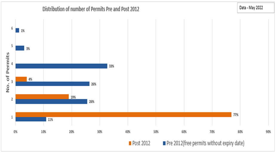
Residents raised a number of issues during the
consultation including the lack of parking availability and the inequity of the
number of permits available to residents based on the date of application of
permit.
The feedback generally supports that the current
residential parking schemes are inconsistent and inequitable.
To provide a framework in the management of the
residential parking permit scheme, a Residential Parking Permit Policy has been
drafted to enable Council to provide a balanced and consistent approach to the
issuance of residential parking permits.
Benchmarking
A detailed benchmarking exercise was undertaken to identify strategies
in place in similar Councils’ Parking Permit Schemes. Results are
detailed in the table below
|
Council
|
Max. # of permits
|
Permit Fees
|
|
1st Permit
|
2nd Permit
|
3rd Permit
|
|
Whitehorse
|
3
|
$14
|
$62
|
$118
|
|
Glen Eira
|
3
|
Free
|
$100
|
$150
|
|
Port Phillip
|
3
|
Resident
$87
|
Foreshore
$64
|
Visitor
$122
|
|
Merri-bek
|
2
|
$45
|
$127.30
|
|
|
Maroondah
|
3
|
$48
|
$84
|
$130
|
SUPPORTING
REPORT DETAILS
Legislative and Risk Implications
There are no legal or risk implications arising from
the recommendation contained in this report.
Equity, Inclusion, and Human Rights Considerations It is considered that the subject matter does not raise any human rights
issues.
Community Engagement
The community engagement was designed to find out the community’s views on
whether they support everyone being on the same scheme, how we should
transition people across and what type of pricing structure people support.
The survey, which was conducted through Your Say, also
provided three parking scheme options. These were:
1. The status
quo
2. One permit
free and payment for additional permits to a maximum of three and;
3. Payment for
all three permits
The results of the survey are as follows
1. Your
Say - Community Consultation Survey Analysis
i. Survey was open from 1 August to
31 August 2022.
ii. Survey Questions are detailed in
Appendix 1 for reference.
iii. 1,238 people participated in the
survey.
iv. 84% of the participants were
residents.
v. 77.4% indicated that access to parking
was up to their expectations.
vi. The survey (on whether we should
transition to a single scheme) provided the following scenario for
consideration:
“We attempt to balance the parking spaces
available with the needs of residents in a fair and equitable manner. Below is
a case study to help explain the permit situation. Jack has two parking
permits that were issued in February 2012. These parking permits were issued
free of charge with no expiry date. Jack’s neighbour John moved in
recently and has applied for two parking permits. This will cost John $76
annually (under the current scheme). What action should Council take in this
scenario?”
The results are as follows:
|
Survey Options
|
Responses
|
Additional information/Themes
|
|
Honour Jack’s historical
permits indefinitely
|
52.8%
|
|
|
Apply an expiry date to
Jack’s permits and then transition his permits to the new parking
permit scheme
|
21.3%
|
|
|
Move Jack immediately onto the new
parking scheme with the associated annual fees
|
7.6%
|
|
|
Other
221 responses
|
18.3%
|
Issue one or two free permits
|
|
Free
permits for everyone
|
|
|
|
Individual/specific issues e.g.
Overdevelopment of Whitehorse, Charge tenants not ratepayers, Misuse of
permits.
|
The conclusion from this information is that in
spite of strong participation from the free permit holders who voted to retain
a fee free scheme, approximately 47.2% (combined percentage for those who voted
for some form of transition) voted for a transition from existing dual scheme
to a single scheme.
vii. The following question sought feedback in
relation to if we transition, when do we do it?
Survey results are as follows
 60.9% indicated transition should take
place within 3-6 months.
60.9% indicated transition should take
place within 3-6 months.
viii. The survey also provided respondents the
opportunity to provide any other feedback on the review of the Residential
Parking Permits. The responses had the following themes:
· Free Permits for all
· One or two permits free
· Individual/specific issues e.g. Overdevelopment of
Whitehorse, signage issues, enforcement, consideration to be given to elderly
and concession card holders, review the number of permits issued to avoid over
subscription, e.g. issue a maximum of two permits instead of three permits.
ix. Permit fee and survey results for
details of the fee structure are detailed below. Note the revenue projection is
based on the current fee structure.
(Note: Under the current scheme only concession card
holders can get one permit for free)
Financial and Resource Implications
The Permit fee structure detailed below provides a
series of options. Note the revenue projection is based on the current fee
structure (Note: Under the current scheme only concession card holders can get
one permit for free).
The proposal is to adopt Model 1 (below) generating in
excess of $81,000 annually. The fee structure will be part of the annual
budget process.
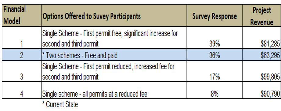
Innovation and Continuous Improvement
This initiative is part of the Community Safety
continuous improvement program with the aim of improving customer engagement
and experience, providing a consistent scheme that delivers an equitable and
consistent product, acknowledges feedback in the provision of a fee exempt
permit and improves access to on street parking reducing congestion
Collaboration
No collaboration
was required for this
report.
Conflict of Interest
Council officers involved in the preparation of this
report have no conflict of interest in this matter.
Conclusion
The rationalisation of the residential parking
framework to a single scheme will provide efficiencies in administration,
consistency in application and support residents by improving access to on
street parking.
Attachment
1 Residential
Parking Permit Policy - Draft 2022
At 8.55pm the Mayor called a five minute recess as the
meeting had approached two hours in duration.
At 9.00pm the meeting recommenced.
Council Minutes 28
November 2022
11.6 Public
Toilet Service Policy
City Services
Director
Infrastructure
ATTACHMENT
SUMMARY
A Public Toilet
Service Policy has been developed to inform decisions about when public toilets
are open. The Policy applies to ‘external public toilets’ that can
be accessed directly from the outside and not through another facility.
The Policy is not proposed to
cover the renewal or upgrade of toilets or the provision of new facilities. These
are covered in Council’s Asset Plan, Open Space Strategy, Play Space
Strategy and relevant masterplans.
Key Matters
A Public Toilet Service Policy
has been developed and is provided in Attachment 1. The Policy is to inform
decisions about when public toilets are open. The Policy applies to
‘external public toilets’ that can be accessed directly from the
outside and not through another facility.
The Policy does not cover the
renewal or upgrade of toilets or the provision of new facilities. These are
covered in Council’s Asset Plan, Open Space Strategy, Play Space Strategy
and relevant masterplans.
There was some valuable feedback
received from the community during the consultation in developing the Policy.
While some were relevant to the Policy, others related to improvement
opportunities and many of these improvement suggestions will be implemented
within the existing budget allocation.
The Public Toilet Service Policy
can be used to consider extending or changing the service. Any service changes
that require an increase in funding will need to be considered in developing
future budgets.
Strategic
Alignment
The relevant sections of Council’s key strategic
documents to the provision of public toilets are:
Council Plan 2021–2025
Strategic Direction 4: Our Built Environment;
Movement, and Public Places
Objective 4.1: Assets, facilities and urban design of
a quality that provides the highest levels of utility and enhances the
connection between the built, natural, heritage and social environments.
4.1.1:Plan, build, renew
and maintain community assets and facilities to meet current and future service
needs in an environmentally, financially and socially sustainable way.
Health and Wellbeing Plan 2021-2025
There is reference to opening toilet facilities in the
strategy to achieve the objective of more liveable neighbourhoods:
Neighbourhood Liveability
A liveable neighbourhood is one that is safe,
accessible and attractive, and provides good connectivity
Objective:
By 2025 our community will enjoy more liveable
neighbourhoods
Strategies to achieve the objective:
Seek opportunities to open up and diversify use of
Council spaces and facilities for multi-use, e.g. on-demand lighting, casual
use sports infrastructure such as basketball/netball rings, oval walking
tracks, picnic seats, community gardens; unlock athletics tracks, open toilet
facilities.
Policy
A Public Toilet Service Policy has been developed and
is provided in Attachment 1. The Policy is to inform decisions about when
public toilets are open.
The Policy includes the following evaluation criteria
to assess the opening times of external public toilets:
1. Demand
2. Safety /
Community Impact
3. Cost
The evaluation criteria will be applied to each of the
Council public toilet facilities to obtain an overall score when requests for
additional opening times are received. Facilities that are ranked high or very
high will be considered for extending the opening hours subject to budget
considerations.
The community was generally supportive of the Policy
and provided some valuable feedback on the public toilet service. There are
details provided in the Community Engagement section of this report. There are
some immediate improvements that can be implemented within the current budget
such as later closing times and additional cleans of selected toilets at
popular parks.
background
Council Resolutions
There have been recent resolutions of Council
regarding public toilets, including:
· (28 June 2021) A Public Toilet Strategy be developed
within the existing Operating Budget 2021/22; and
· (25 November 2021) A range of criteria need to be
assessed when considering the opening times of a public toilet and it is
recommended that the planned review of public toilets be developed and be used
to inform requests of the need for additional services.
This Policy has been developed so that the
decision making process is transparent and based on relevant factors.
Discussion and Options
The recent decisions have related to the service
provided by the existing toilets so a Public Toilet Service Policy has been
developed to guide future decisions in this area.
The option of developing a Public Toilet Strategy that
included renewal and upgrade of toilets and the provision of new facilities was
considered, however the renewal or upgrade of toilets is assessed in accordance
with Council’s Building Asset Management Plan and funded by a designated
capital works program account.
The provision of new public toilet facilities needs to
be considered strategically. There is a significant capital cost to provide a
new facility as well as ongoing servicing, cleaning, maintenance and renewal.
There are other strategic documents to advise potential new public toilet
facilities including the Open Space Strategy, Play Space Strategy and relevant
masterplans.
SUPPORTING REPORT DETAILS
Legislative and Risk Implications
There is no statutory or legislative requirement for
councils to provide public toilet facilities.
There are risks associated with extending the opening
hours of toilets. Public toilets can attract unsocial activities, graffiti and vandalism.
The Policy considers these matters.
Equity, Inclusion, and Human Rights Considerations
All toilets that are renewed or upgraded need to
comply with the relevant Australian Standards and building codes to ensure that
have the required disability access. Toilets are open to meet the needs of the
users in the area and this Policy is designed to outline how Council makes
decisions in this area.
Community Engagement
There was an online survey on Council’s Your Say
website to consult on a Draft Public Toilet Service Policy. The survey was open
from 30 June 2022 to 17 July 2022. There were 39 survey responses received.
There were four questions asked and opportunity for comment. These are
summarised below:
1. Do you have
any comments on the draft Public Toilet Service Policy?
YES = 14 (35.9%)
NO = 25 (64.1%)
2. The draft
Policy includes the following evaluation criteria to assess the opening times
of external public toilets:
1. Demand
Measurement includes:- estimate of the weekday use of the area- location of
other public toilets in the vicinity
2. Safety /
Community Impact Measurement includes:- how visible the entry points can be
observed by others in the area- higher score for fully automated toilets
3. Cost
Measurement includes:- relative cost of opening the facility including
servicing, cleaning and maintenance
Do you think the proposed criteria are suitable?
YES = 30 (76.9%)
NO = 9 (23.1%)
Do you have any suggestions for what else Council
should consider in making decisions about toilet opening?
YES = 13 (33.3%)
NO = 26 (66.7%)
Do you use the ‘The National Public Toilet
Map’ website to locate the nearest public toilet?
YES = 7 (17.9%)
NO = 12 (30.8%)
19 = (48.7%) I will now that I aware of it
The comments received have been considered to help
improve the provision of public toilet services. These include:
1. Additional
cleaning at selected parks
2. Later
closing time at selected parks during summer
3. Request for
additional lighting /or brighter lighting at selected toilets.
4. Feasibility of
providing scented air fresheners
5. More
directional signs to toilets
There are some immediate improvements that can be
implemented within the current budget such as later closing times and
additional cleans of selected toilets at popular parks.
Financial and Resource Implications
There are no financial or resource implications
arising from the recommendation contained in this report.
There is $269,638 allocated in the Budget 2022/23 to
open, close, clean and service public toilets. This includes regular cleaning,
periodic major cleaning and special call-out cleaning for unexpected events or
urgent cleans.
The public toilets in Springfield Park and Mont Albert
Reserve were open seven days per week in 2021/22 as a proof of concept trial.
The trial has been successful and the toilets continue to be open seven days
per week.
The Public Toilet Service Policy can be used to
consider extending or changing the service. Changes arising may require an
increase in funding that would need to considered in developing future budgets.
Innovation and
Continuous Improvement
The servicing of public toilets has been optimised
over the years to maximise the service performance within the available budget.
Collaboration
The Policy was developed in collaboration with all key
stakeholders involved in the management of external public toilets.
Conflict of Interest
Council officers involved in the preparation of this
report have no conflict of interest in this matter.
Conclusion
It is recommended that Council endorses the Public
Toilet Service Policy. The Policy will then be used in response to requests
from the community to extend the opening hours of a toilet.
Attachment
1 Public
Toilet Service Policy - Final
Council Minutes 28
November 2022
11.7 Tender
Evaluation (Contract 30405) Sportsfields and Turf Management Products, Services,
Minor Works and Consultancy Services
Parks
and Natural Environment
Director Infrastructure
ATTACHMENT
SUMMARY
To consider tenders received for the provision of a range of services for Sportsfields and Turf Management
Products, Minor Works and Consultancy and to recommend the acceptance of the
tenders received from the panel of consultants and contractors as set out below
for each of six categories on a Schedule of Rates basis for a period of five
years commencing on 1 December 2022 with no option for extension; and to consider the estimated expenditure over the
life of the contract for the amount of $20M, including GST.
|
Council Resolution
Moved by Cr Liu, Seconded by Cr Skilbeck
1. Accept the
tender and sign the formal contract document for Contract 30405 for
Sportsfields and Turf Management Products, Minor Works and Consultancy
Services, on a Schedule of Rates basis for a period of five years with no
option for extension commencing on 1 December 2022 for the following
contractors/consultants:
· Tees & Greens Pty Ltd (ABN 74 125 592 207)
· Ten Burren Irrigation Designs Pty Ltd (ABN 29 093
486 947)
· Evergreen Turf Group Pty Ltd (ABN 17 007 427 536)
· Yellow Box Computing (ABN 33 432 354 753 )
· Gemlach Pty Ltd t/a Douglas Sheet Metal and
Engineering (ABN 71 095 633 177)
· Landscape Two Pty Ltd ATF Waterless Turf Unit Trust
t/a Smartgrass (ABN 38 127 661 892)
· Maddocks Sports Pty Ltd (ABN 38 059 538 635)
· Smart Water Corporation Pty Ltd (ABN 37 158 488 236)
· CS, ML & SJ Beard t/a Linga Longa Park Pty Ltd
(ABN 61 124 230 959)
· Greenway Turf Solutions Pty Ltd (ABN 49 600 618 657)
· Australian Agribusiness (Holdings) Pty Ltd Trading
as Nuturf Australia (ABN 61 135 355 958)
· ProWire Fencing Group Pty Ltd t/a Melbourne Chain
Wire Fencing (ABN 91 609 191 460)
· Sandbelt Industries (Vic) Pty Ltd (ABN 21 131 364
731)
· Oxley Nets Pty Ltd (ABN 83 735 245 519)
· Greenshed Pty Ltd t/a Living Turf (ABN 70 105 996
307)
· Sportsturf Consultants t/a STRI Australia (ABN 39
055 904 526)
· Ashworth discretionary trust t/a A Star Sports
Industries Pty Ltd (ABN 43 779 134 169)
· Marsh Developments P/L t/a Superior Green (ABN 68
095 305 918)
2. Authorise the Director of Infrastructure
under the delegation of the Chief Executive Officer to award the contract.
Carried Unanimously
|
Key Matters
Whitehorse City Council has sought a range of suitably
qualified and experienced consultants and contractors to support the Parks and
Natural Environment Department in the provision of their planned and reactive
sports field and turf services.
The growing expectations on the delivery of this
function of Council and the increasing need for specialist supporting advice in
matters of chemical use, design of irrigation systems, ground quality control,
new technology for turf and construction of AFL/Cricket/FFA Australia standard
installations has seen the need to engage specialists consultants in these
fields.
Furthermore, these services are also sought to support
the growing need for junior and professional sporting opportunities across the
municipality.
Council had the option to extend the current Contract
30084 which is due to expire 30 November 2022 however the team made a conscious
decision to re-tender given the nature of the current post-Covid market,
difficulty in obtaining consistent contractors and also changes to technology
and equipment in this area. The current
contract also did not accommodate the flexibility or address the needs of
Council within such an unprecedented environment. Council is in a better
position now having successfully navigated through the previous contract.
The services offered under this panel include:
Supply, Delivery and Installation of Products and Services
including:
· Granular Fertiliser
· Liquid Fertilisers
· Soil Amendments
· Herbicides
· Insecticides
· Fungicides
· Instant Turf
· Planting Turf
· Grass Seed
· Sand
· Top Dressing
· Scarifying
· Verti Draining
· Laser Levelling
· Irrigation Parts
Minor Works
including:
· Synthetic Installations
· AFL Goal Posts
· Soccer Goals
· Coaches Boxes
· Interchange Boxes
· Fencing Repairs
· Drainage Works
· Soil Testing
· Sand & Gravel Testing and Analysis
· Trench Consolidation
· Irrigation Systems
Design, Audit
and Advisory Consultancy Services including:
· Drainage Design
· Irrigation Design
· Site Surveys
· Sportsfield Condition Assessments
· Training Net Design
· Concept Design
· Auditing
· Advisory Services
Strategic Alignment
This report is consistent with Council’s procurement
policy and aligns with Council’s commitment to social and environmental
sustainability and support to local business.
Background
The tender was advertised in The Age Newspaper on Saturday 20 August 2022
and closed on Wednesday 21 September 2022. Twenty-Five (25) tenders were
received, some of which tendered for multiple services in the specification.
Eighteen (18) Submissions that were considered best value have been recommended
for the panel. There was one (1) non-conforming tender.
The tenders were evaluated
against the following criteria and weightings:
· Price (35%)
· Capability (30%)
· Credibility (25%)
· Social / Environmental / Local (10%)
· Occupational Health & Safety and Equal Opportunity
(Pass/Fail)
Given the volume of work likely to be generated
through the different specialist areas of the contract, a number of
consultants/contractors have been selected, based on their ratings against the
above criteria.
The tenders listed above are considered to provide the
best value for money for this panel contract and were able to demonstrate the
resources, response time and expertise required to undertake the service and
works within the tender specification at a competitive market price. The
successful contractors have all required insurances, risk management/OHS plans
and other required documents in place.
SUPPORTING REPORT DETAILS
Legislative and Risk Implications
There are no legal or risk implications arising from
the approval for this plan.
Consultation
Councils Procurement team have been consulted
extensively to ensure that the procurement is compliant with the Procurement
Policy. Extensive consultation has also occurred across the Parks and Natural
Environment teams and Leisure and Recreation Services.
Collaboration
Collaboration with the Northern Regional Procurement
Network was sought to investigate the potential of broadening the scope,
further increasing the savings and improving environmental impact.
Unfortunately at this point in time Council’s neighbouring municipalities
have current contracts in place which negated the opportunity to collaborate
immediately however, it has remained on the agenda as an opportunity to roll in
or collaborate at the five-year term.
Financial and Resource Implications
The contract for the provision of Sports fields and
Turf Management Products, Minor Works and Consultancy Services is based on a
Schedule of Rates. The rates are subject to a CPI adjustment on each
anniversary of the contract.
The financial advantage of each tender submission was
determined by comparing the rates for all services required by Council under
this contract with careful consideration given to those that are used most
frequently by Council. The financial analysis was added to the robust evaluation
outcome of the consultant’s credibility and capability to undertake the
services required within the specification.
The estimated expenditure under this contract over the
contract term is $20M, including GST. The costs incurred under this contract
will be charged to the relevant endorsed recurrent and capital budgets.
Discussion and Options
The recommended contractors provide a high level of
expertise as well as knowledge into best practice processes and products.
The successful contractors:
· 100% of products are certified/recognised as
environmentally safe.
· 100% of suppliers have policies on Social and
Environmental Sustainability
Conflict of Interest
Council officers involved in the preparation of this
report have no conflict of interest in this matter.
Conclusion
The next steps are to gain endorsement from Council
for the panel contract as per the above recommendation and then execute the
contractual documents with the preferred contractors. It is intended that the
contract commence from 1 December 2022.
Attachment
1 Tender
Evaluation - Contract 30405 Sportsfield and Turf Management Products, Services,
Minor Works and Consultancy Services
Whitehorse City Council
designates this attachment and the information contained in it as CONFIDENTIAL
INFORMATION
Council Minutes 28
November 2022
11.8 Councillor
Appointments to Organisations and Community Bodies
Governance and Integrity
Director
Corporate Services
ATTACHMENT
SUMMARY
Each year, Council appoints Councillor Representatives to various
internal and external committees, organisations and other bodies for the
forthcoming year.
These committees provide an important mechanism for consultation with
the community and key stakeholders. Internal committees and networks
provide advice to Council but do not make formal decisions.
Appointments for the committees and other bodies are required; this
report outlines how many appointments are needed, the term and whether a
substitute is needed. The attachment outlines the purpose of the
Committee and how often it meets to assist Councillors with time commitments.
It is proposed to
conduct a full review of Council committees and membership requirements in the
first half of 2023.
|
The Mayor called for nominations on
each Committee, where there was more than the required nominations received
votes were taken in order of the nominations.
Following are the appointments to
each committee and details of where votes were required:
|
Committee
|
Delegate
|
|
Whitehorse Manningham Regional
Library Corp.
(Two Councillors, new two year
term commencing 2022)
Votes:
|
Cr
Skilbeck
|
Received
3 votes
|
|
Cr
Davenport
|
Received
6 votes
|
|
Cr Liu
|
Received
2 votes
|
Cr Davenport received a majority
of votes and was appointed as the delegate.
A further vote was put for the
second delegate.
|
Cr
Skilbeck
|
Received
6 votes
|
|
Cr Liu
|
|
Cr Skilbeck was appointed the
second delegate.
|
Cr Davenport
Cr Skilbeck
|
|
Whitehorse Sports and Recreation
Network
Votes:
(Two Councillors, new two year
term commencing 2022)
|
Cr
Stennett
|
Received
7 votes
|
|
Cr Cutts
|
Received
no votes
|
|
Cr Carr
|
Received
1 votes
|
Cr Stennett received a majority of
votes and was appointed as the delegate.
|
Cr Cutts
|
Received
6 votes
|
|
Cr Carr
|
Received
5 votes
|
Cr Cutts received the majority of
votes and was appointed the second delegate.
|
Cr Stennett
Cr Cutts
|
|
Municipal Association of Victoria
(One Councillor and One substitute
Councillor)
|
Cr Munroe
Substitute: Cr Lane
|
|
Whitehorse Business Group
(Two Councillors)
|
Cr Munroe
Cr Massoud
|
|
Victorian Local Governance
Association
(One Councillor and One substitute
Councillor)
|
Cr Massoud
Substitute: Cr Lane
|
|
Eastern Affordable Housing
Alliance
(One Councillor, new two year term
commencing 2022)
|
Cr Massoud
|
|
Eastern Alliance for Greenhouse
Action (EAGA) Executive Committee
(One Councillor)
Votes:
|
Cr McNeill
|
Received 1
vote
|
|
Cr Barker
|
Received
5 votes
|
|
Cr Liu
|
Received
5 votes
|
Cr McNeill was eliminated with the
lowest number of votes.
A further vote was put.
|
Cr Barker
|
Received
6 votes
|
|
Cr Liu
|
|
Cr Barker received majority of
votes and was appointed.
|
Cr Barker
|
|
Eastern Region Group
(Mayor, Deputy Mayor and CEO)
|
Cr Lane, Mayor
Cr Cutts, Deputy Mayor
|
|
Eastern Transport Coalition
(One Councillor)
|
Cr Liu
|
|
Metropolitan Transport
Forum
(One Councillor)
|
Cr McNeill
Substitute: Cr Munroe
|
|
CEO Employment Matters Committee
(All Councillors)
|
All Councillors
|
|
Audit and Risk Committee
(Two Councillors)
|
Cr Barker
Cr Skilbeck
|
|
Heritage Steering Committee
(Two Councillors)
|
Cr McNeill
Cr Stennett
|
|
Visual Arts Advisory Committee
(Up to Two Councillors as
Co-Chairs)
|
Cr Carr
Cr Stennett
|
|
Whitehorse Disability Advisory
Committee (WDAC)
(Two Councillors, One as Chair)
|
Cr McNeill
Cr Massoud
|
|
Whitehorse Reconciliation Advisory
Committee
(One Councillor as Chair)
|
Cr Massoud
|
|
Domestic Animal Management Plan
Advisory Committee
(Two Councillors)
|
Cr Carr
Cr Barker
Substitute: Cr Massoud
|
|
Major Projects Councillor
Reference Group
(All Councillors)
|
All Councillors
|
|
Environment and Sustainability
Reference Group
(Two Councillors, One as Chair)
Votes:
|
Cr Cutts
|
Received
9 votes
|
|
Cr
McNeill
|
|
|
Cr
Massoud
|
|
Cr Cutts received a majority of
votes and was appointed as the delegate.
A further vote was put for the
second delegate.
|
Cr
McNeill
|
Received 1
vote
|
|
Cr
Massoud
|
Received
10 votes
|
Cr Massoud was appointed the
second delegate.
|
Cr Cutts
Cr Massoud
|
|
Tree Assistance Fund Decision
Panel
(Two Councillors)
|
Cr McNeill
Cr Stennett
|
|
Community Grants Program
(The Mayor and five Councillors)
|
Cr Lane, Mayor
Cr Carr
Cr Cutts
Cr Davenport
Cr Munroe
Cr Stennett
|
|
Local Government Working Group on
Gambling
(Two Councillors
|
Cr Massoud
Cr Barker
|
|
|
Council
Resolution
Moved by Cr Barker, Seconded by Cr Liu
That Council:
1. Determine Councillor Representative Appointments to the
committees, organisations and other bodies.
2. Advise
the committees, organisations and other bodies of the Councillor
Representative appointments.
3. Notes
a review of the Committees is being undertaken and that a further report will
be presented to Council in 2023.
Carried
Unanimously
|
Key Matters
· The Local
Government Act 2020 (the Act) does not reference advisory committees and it is
up to each Council to determine what committees it requires except for:
§ The Audit and
Risk Committee is a legislated committee (as per the Act)
§ The CEO
Employment Matters Committee (EMAC) is supported by a Council adopted Policy as
required by the Act.
· For External
Organisations, Council is a member or participant in a range of external
organisations at a local, regional or sector level. Councillors are appointed
to represent Council as delegates to those organisations. In some cases, an
alternate is also appointed who can attend if the primary Councillor is not
available.
· Internal Whitehorse Committees and networks have a
terms of reference that outlines the purpose and how the meetings are
governed. They are advisory in nature and provide recommendations to
Council.
· The Community Grants Committee is currently under
review in line with the recent Victorian Auditor General (VAGO) report on
‘Fraud Control Over Local Government Grants’ and will be reported
to Council in December.
· Since the 2021 appointments the following changes are
required:
§ The LG Waste Management Forum no longer exists as of 1
July 2022. The Metropolitan Waste and Resource Recovery Group has been
abolished and staff and activities have transferred to newly-formed Recycling
Victoria (part of DELWP) under the Circular Economy (Waste Reduction and Recycling)
Act 2022.
§ Name change for the CEO Employment Matters Committee,
formerly known as ‘Review of the Chief Executive Officer’s
development’.
Discussion and Options
Council to consider and resolve appointments to the groups as detailed
below:
|
No.
|
Committee
|
Councillor Delegate
2022/2023
|
|
EXTERNAL COMMITTEES
|
|
1.
|
Municipal Association of Victoria
(One Councillor and One substitute Councillor)
|
Cr Munroe
Substitute: Mayor Cr Lane
|
|
2.
|
Whitehorse Business Group
(Two Councillors)
|
Cr Munroe
Cr Massoud
|
|
3.
|
Whitehorse Manningham Regional Library
Corp.
(Two Councillors, new two year term
commencing 2022)
|
Cr Davenport
Cr Skilbeck
|
|
4.
|
Victorian Local Governance Association
(One Councillor and One substitute
Councillor)
|
Cr Massoud
Substitute: Mayor Cr Lane
|
|
5.
|
Eastern Affordable Housing Alliance
(One Councillor, new two year term
commencing 2022)
|
Cr Massoud
|
|
6.
|
Eastern Alliance for Greenhouse Action
(EAGA) Executive Committee
(One Councillor)
|
Cr Barker
|
|
7.
|
Eastern Region Group
(Mayor, Deputy Mayor and CEO)
|
Mayor Cr Lane
Deputy Mayor: Cr Cutts
|
|
TRANSPORT GROUP OF COMMITTEES
|
|
8.
|
Eastern Transport Coalition
(One Councillor)
|
Cr Liu
|
|
9.
|
Metropolitan Transport Forum
(One Councillor)
|
Cr McNeill
Substitute: Cr Munroe
|
|
|
INTERNAL COMMITTEES
|
|
|
10.
|
CEO Employment Matters Committee
(All Councillors)
|
All Councillors
|
|
11.
|
Audit and Risk Committee
(Two Councillors)
|
Cr Skilbeck
Cr Barker
|
|
12.
|
Heritage Steering Committee
(Two Councillors)
|
Cr Stennett
Cr McNeill
|
|
13.
|
Visual Arts Advisory Committee
(Up to Two Councillors as Co-Chairs)
|
Cr Carr
Cr Stennett
|
|
14.
|
Whitehorse Disability Advisory Committee
(WDAC)
(Two Councillors, One as Chair)
|
Cr Massoud
Cr McNeill
|
|
15.
|
Whitehorse Reconciliation Advisory
Committee
(One Councillor as Chair)
|
Cr Massoud
|
|
16.
|
Domestic Animal Management Plan Advisory
Committee
(Two Councillors)
|
Cr Barker
Substitute: Cr Massoud
|
|
17.
|
Major Projects Councillor Reference Group
(All Councillors)
|
All Councillors
|
|
18.
|
Whitehorse Sports and Recreation Network
(Two Councillors)
|
Cr Stennett
Cr Cutts
|
|
19.
|
Environment and Sustainability Reference
Group
(Two Councillors, One as Chair)
|
Cr Cutts
Cr Massoud
|
|
20.
|
Tree Assistance Fund Decision Panel
(Two Councillors)
|
Cr Stennett
Cr McNeill
|
|
21.
|
Community Grants Program
(The Mayor and five Councillors)
|
Cr Lane, Mayor
Cr Carr
Cr Cutts
Cr Davenport
Cr Munroe
Cr Stennett
|
|
22.
|
Local Government Working Group on
Gambling
(Two Councillors)
|
Cr Massoud
Cr Barker
|
SUPPORTING
REPORT DETAILS
Legislative and Risk Implications
The
Local Government (Governance and Integrity) Regulations 2020 (regulation
7(1) (a) and (b)) provide for the following exemptions to the conflict of
interest provisions (as per s 129(g) of the Act) in relation to committees:
· The nomination or
appointment by the Council of a Councillor to a position for which the
Councillor will not be remunerated.
· The nomination or
appointment by the Council of a Councillor to a position in the Municipality.
There are no
legal or risk implications arising from the recommendation contained in this
report.
Equity, Inclusion, and Human Rights
Considerations – required
It
is considered that the subject matter does not raise any human rights
issues.
Financial
and Resource Implications
There are no
financial or resource implications arising from the recommendation contained in
this report.
Innovation and Continuous Improvement
There are no
Innovation and Continuous Improvement matters arising from the
recommendation contained in this report.
Collaboration
No collaboration was required for this
report.
Conflict of Interest
The Local
Government Act 2020 requires members of Council staff, and persons engaged
under contract to provide advice to Council, to disclose any direct or indirect
interest in a matter to which the advice relates.
Council
officers involved in the preparation of this report have no conflict of
interest in this matter.
Conclusion
Each year
Councillors are appointed to a range of internal and external committees for
the upcoming year.
A full review
of all Committees will occur in early 2023 to review structure and alignment to
the Council Plan.
Appointments
are required for the committees outlined in this report.
Attachment
1 Whitehorse Committees for Councillor
Representatives
Council Minutes 28
November 2022
11.9 Records
of Informal Meetings of Councillors
|
Councillor Informal Briefing – 14
November 2022 6.30-6.50pm
|
|
Matter/s Discussed:
|
Councillors Present
|
Officers Present
|
|
· Council
Agenda Items
· Public
Questions
|
Cr Lane (Mayor & Chair)
Cr Cutts (Deputy Mayor)
Cr Liu
Cr McNeill
Cr Skilbeck
Cr Munroe
Cr Barker
Cr Massoud
Cr Stennett
Cr Carr
Cr Davenport
|
S McMillan
J Green
L Letic
S White
C Altan
V Ferlaino
K Woods
S Lozsan
|
|
Disclosures of Conflicts of Interest
|
None Disclosed
|
|
Councillor /Officer attendance following
disclosure
|
None Disclosed
|
|
Councillor Briefing – 21 November 2022
6.30-pm
|
|
Matter/s Discussed:
·
|
Councillors Present
|
Officers Present
|
|
· Customer
Service Centres
· Council
Plan Review and Budget
· Draft
Council Agenda 28 November 2022
· Whitehorse
Health and Wellbeing Plan 2021-2025 – Annual Action Plan (2022-2023)
· Draft
Affordable Housing Policy
· Councillor
Appointments to Organisations and Community Bodies
· Review
of Ten Year Capital Works Plan
|
Cr Lane (Mayor & Chair)
Cr Cutts (Deputy Mayor)
Cr McNeill
Cr Skilbeck
Cr Munroe
Cr Barker
Cr Massoud
Cr Stennett
Cr Carr
Cr Davenport
|
S McMillan
J Green
L Letic
S Cann
S White
S Sullivan
C Altan
V Ferlaino
K Woods
C Clarke
Z Quinn
D Seddon
R Hood
Z Quinn (Virtual)
K Marriott (Virtual)
S Morison (Virtual)
J Hansen (Virtual)
|
|
Disclosures of Conflict of Interest
|
Councillor Davenport declared a General Conflict of
Interest on the discussion of the Draft Council Agenda for item 11.7
Residential Parking Permit Review, this did not relate to the contents of
the report.
|
|
Councillor /Officer attendance following
disclosure
|
None Disclosed
|
Council Minutes 28
November 2022
12 Councillor Delegate and Conference / Seminar Reports
12.1 Reports
by Delegates
(NB: Reports only from Councillors appointed by Council as delegates to
community organisations/committees/groups):
·
Cr Barker reported on the Domestic Animal Management
Advisory Panel meeting held on 23 November 2022
·
Cr Carr reported on the Visual Arts Advisory Committee
meeting and the Domestic Animal Management Advisory Panel meeting, both held on
23 November 2022
·
Cr Cutts reported on the Environment and Sustainability
Reference Group meeting held on 16 November 2022 and the Whitehorse Sports and
Recreation Network meeting held on 17 November 2022
·
Cr Davenport reported on the Audit and Risk Committee
meeting held on 21 November 2022 and the Visual Arts Advisory Committee meeting
held on 23 November 2022
·
Cr Massoud reported on the meeting of the Local Government Working Group on Gambling held on 16
November 2022 and the Audit and Risk Committee meeting held on 21 November 2022
·
Cr Liu reported on the Environment and Sustainability
Reference Group meeting held on 16 November 2022 and the Eastern Transport
Coalition meeting held on 17 November 2022
·
Cr Skilbeck reported on the Eastern Alliance for Greenhouse
Action Executive Committee meeting held on 28 November 2022
12.2 Reports
on Conferences/Seminars Attendance
·
Cr Munroe reported on the Summer Foundation Annual Public
Forum – a reimagined NDIS held on 25 November 2022.
13 Confidential Reports
|
Council Resolution
Moved by Cr McNeill, Seconded by Cr Munroe
That in accordance with
Section 61 (1) and 66 (2)(a)of the Local Government Act 2020 the Council
should resolve to go into camera and close the meeting for the consideration
of this item, as the matter to be discussed is confidential information for
the purposes of section 3 (1) of the Local Government Act 2020.
This ground applies
because the matter concerns legal and personal information.
Carried
|
13.1 Drainage
of Land - Installation of Outfall Drain - Winton Street, Burwood, and
Surrounding Lands.
The
meeting was closed to the public at 9.42pm
The
meeting was reopened to the public at 9.46pm.
14 Close Meeting
Meeting
closed at 9.47pm.
Confirmed
this 12th day of December 2022
_______________________________
CHAIRPERSON