1 Welcome
|
We give thanks, O God, for the Men and Women of the past whose generous devotion to the common good has been the making of our City. Grant that our own generation may build worthily on the foundations they have laid. Direct our minds that all we plan and determine, is for the wellbeing of our City. Amen. |
|
Whitehorse City Council acknowledges the Wurundjeri Woi-wurrung people of the Kulin Nation as the Traditional Owners of the land we are meeting on and we pay our respects to their Elders past, present and emerging and Aboriginal and Torres Strait Islanders from communities who may be present today. |
Nil
3 Disclosure of Conflicts of Interest
Cr Massoud declared a general conflict of interest on Item 10.1 - 3 Deanswood Road, Forest Hill (LOT 1 TP 251388) – Buildings and works to construct a double storey dwelling, works within four (4) metres of vegetation and tree removal. Cr Massoud resides within close proximity to this address.
4 Confirmation of Minutes of Previous Meeting
Minutes of the Council Meeting 13 May 2024
|
Moved by Cr Skilbeck, Seconded by Cr Liu That the minutes of the Council Meeting 13 May 2024 be confirmed. |
Nil
6.1 D Ellis, Mont Albert North
Item 8.1 - Strabane Avenue-Tyrell Street Crossover, Mont Albert North
Item 8.2 - Management of Aqualink Sites, Box Hill and Nunawading
6.3 T Tescher, Whitehorse Ratepayers & Residents Association
Item 8.2 - Management of Aqualink Sites, Box Hill and Nunawading
6.4 M Mayur, Box Hill South
Item 8.2 - Management of Aqualink Sites, Box Hill and Nunawading
6.5 J Fredman, Fredman Malina Planning Pty Ltd
Item 10.1 - 3 Deanswood Road, Forest Hill (LOT 1 TP 251388) Buildings and works to construct a double storey dwelling, works within four (4) metres of vegetation and tree removal.
6.6 R Padman, Forest Hill
Item 10.1 - 3 Deanswood Road, Forest Hill (LOT 1 TP 251388) Buildings and works to construct a double storey dwelling, works within four (4) metres of vegetation and tree removal.
6.7 D Tribe, Blackburn & District Tree Preservation Society Inc.
Item 10.1 - 3 Deanswood Road, Forest Hill (LOT 1 TP 251388) Buildings and works to construct a double storey dwelling, works within four (4) metres of vegetation and tree removal.
6.8 G Havakis, Forest Hill
Item 10.1 - 3 Deanswood Road, Forest Hill (LOT 1 TP 251388) Buildings and works to construct a double storey dwelling, works within four (4) metres of vegetation and tree removal.
6.9 R Cornell, Burwood
Item 10.2 - 8 Glengarry Avenue, Burwood (LOT 23 LP 27631 17) Construction of two double storey dwellings, removal of protected trees and buildings and works within four (4) metres of protected trees.
6.10 K Earl, Box Hill
Various matters
7 Public Question Time
Question
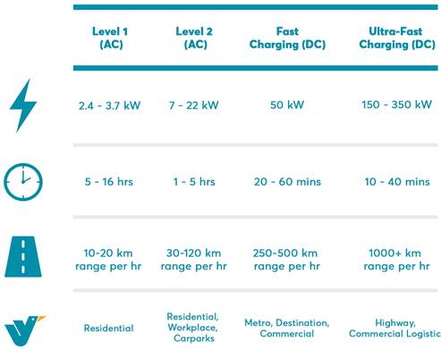
Cities of Knox, Bayside, Moonee Valley, Manningham, Maribyrnong, Darebin and Kingston are all making Council land available for public access EV fast charging. NSW has just announced that 671 kerbside EV chargers will be installed across 16 Council areas. The existing AC slow chargers at shopping centres are not sufficient. Please do not constrain the transition to a net-zero transport system in Whitehorse by doing nothing in item 10.3 of tonight's agenda. Does Council not want to support equitable access to essential infrastructure for all its constituents?
Response
Council acknowledges that the EV charging industry is changing rapidly. At the meeting tonight, Council will consider the option to provide land for the purpose of public accessible EV charging stations.
7.2 K Earl, Box Hill
Question
What is council doing to support the thousands of cyclist being introduced to all the high-rise buildings in Box Hill, no crossing over the railway line, bicycle paths you can count on 1 hand?
Response
Council will continue to support and encourage cycling throughout the municipality and in particular Box Hill as we progressively design and implement priority Easy Ride Routes subject to funding and resource allocation.
Funding for an interim rail crossing in Box Hill is complex and challenging. Council will continue to advocate for an appropriate crossing over the railway line through the State Government Suburban Rail Loop project and at other opportunities.
8.1 Strabane Avenue - Tyrell Street Crossover, Mont Albert North
1. A petition requesting that the crossover requires assessment by Council has been received and signed by 139 signatories in support.
2. The petition request is as follows:
“We the undersigned, request that Council; Attend the site of Tyrell Street & Strabane Avenue, Mont Albert North to meet residents, discuss and assess the importance of the old pedestrian crossover. The crossover presented as vehicle driveway and had been used by Pedestrians & Cyclists for over 40 years.”
|
Moved by Cr McNeill, Seconded by Cr Liu That Council: 1. Receives the petition be received and referred to the Director City Development for appropriate action and response. 2. Notifies the Head Petitioner of the outcome of this resolution. |
8.2 Management of Aqualink Sites Box Hill and Nunawading
1. A petition requesting that the Whitehorse Council maintain management of both Aqualink sites and that the facilities not be outsourced by Council has been received and signed by 5050 signatories in support.
2. This petition request is as follows:
“The ratepayers and residents of the City of Whitehorse and members of the Council Aqualinks at Box Hill and Nunawading requesting that the Whitehorse Council maintain management of both Aqualink sites and that the facilities not be outsourced.”
|
MOTION Moved by Cr Lane, Seconded by Cr Li That Council: 1. Receives the petition and refers it to the Director Community Services for appropriate action and response; and 2. Notifies the Head Petitioner of the outcome of this resolution. |
|
Cr Davenport proposed an amendment to include item 3 being ‘Place a copy of the outcome on Council’s website.’ The amendment was accepted by the mover and seconder and became the substantive motion. The Mayor put the substantive motion which became the council resolution as follows: |
|
Moved by Cr Lane, Seconded by Cr Liu That Council: 1. Receives the petition and refers it to the Director Community Services for appropriate action and response; and 2. Notifies the Head Petitioner of the outcome of this resolution. 3. Place a copy of the outcome on Council’s website. |
9.1 Notice of Motion - Cr Davenport - Differential Rates
|
MOTION Moved by Cr Davenport, Seconded by Cr Barker That Council receives a report on the feasibility of introducing a differential rate on land that contains: a) Retirement villages within the 2025 version of council’s revenue and rating plan; b) Vacant residential properties within the 2025 version of council’s revenue and rating plan. Cr Skilbeck requested clarification on the ‘2025’ date, this was amended to accurately reflect the dates of the revenue and rating plan being 2025/2026 – 2027-2028. Inclusion of the amended dates was accepted by the mover and seconder and became the substantive motion. The Mayor put the substantive motion in parts as follows: |
|
Part 1 That Council receives a report on the feasibility of introducing a differential rate on land that contains: a) Retirement villages within the 2025/2026 – 2028/2029 version of Council’s Revenue and Rating Plan For: Cr Barker, Cr Carr, Cr Cutts, Cr Davenport, Cr Lane, Cr Liu Cr Massoud, Cr McNeill, Cr Stennett (9) Against: Cr Munroe, Cr Skilbeck (2) CARRIED |
|
Part 2 That Council receives a report on the feasibility of introducing a differential rate on land that contains: b) Vacant residential properties within the 2025/2026 – 2028/2029 version of council’s revenue and rating plan. For: Cr Barker, Cr Carr, Cr Cutts, Cr Davenport, Cr Liu Cr Massoud, Cr McNeill, Cr Stennett (8) Against: Cr Munroe, Cr Skilbeck, Cr Lane (3) CARRIED |
|
At the conclusion of voting in parts the following became the council resolution: |
|
Moved by Cr Davenport, Seconded by Cr Barker That Council receives a report on the feasibility of introducing a differential rate on land that contains: a) Retirement villages within the 2025/2026 – 2028/2029 version of Council’s Revenue and Rating Plan; b) Vacant residential properties within the 2025/2026 – 2028/2029 version of Council’s Revenue and Rating Plan. |
Attendance:
Mayor, Cr Massoud having declared a conflict of interest in Item 10.1 - 3 Deanswood Road, Forest Hill (LOT 1 TP 251388) – Buildings and works to construct a double storey dwelling, works within four (4) metres of vegetation and tree removal left the chamber at 8.27pm. Deputy Mayor, Cr Davenport chaired the meeting for this item.
10.1 3 Deanswood Road, Forest Hill (LOT 1 TP 251388) – Buildings and works to construct a double storey dwelling, works within four (4) metres of vegetation and tree removal
|
Department |
City Planning and Development Director City Development |
WH/2023/409
Attachment
SUMMARY
This application proposes buildings and works for a replacement double storey dwelling and the removal of four (4) protected SLO2 trees located within the site. The trees are recommended for removal as they are within the proposed building footprint and are considered acceptable for removal. The design also retains all large established trees within the subject site and proposes additional tree planting for landscaping.
The planning process requires buildings and works (dwelling and associated works) to be assessed for first floor wall setbacks to the north and south side boundaries for a double storey dwelling and works within 4 metres of protected SLO2 trees on the adjacent properties to the north and south. Subject to the implementation of tree protection measures including the submission of a specialised tree management plan, the proposed development will not adversely impact the health of any protected SLO2 trees.
If approved, the applicant proposes seven (7) replacement canopy tree plantings on the site, with three (3) to be located in the front setback, two (2) located adjacent to the north side boundary and two (2) located towards the rear boundary. The proposed replanting species are listed as Lightwood (Acacia implexa), Yellow Gum (Eucalyptus leucoxylon macrocarpa ‘Rosea’) and Red Box (Eucalyptus polynathemos) species.
This application was advertised, and a total of 14 objections were received. The objections raised issues with vegetation removal, privacy, proposed built form and consistency with neighbourhood character. A Consultation Forum was held on 26 March 2024 chaired by Councillor Lane, at which the issues were explored, however no resolution was reached between the parties.
This report assesses the application against the relevant provisions of the Whitehorse Planning Scheme, as well as the objector concerns. After assessment by Council’s consulting arborist, urban greening officer and planning officers the proposal is recommended for support, subject to conditions.
|
Moved by Cr Lane, Seconded by Cr Skilbeck That Council: A Being the Responsible Authority, having caused Application WH/2023/409 for 3 Deanswood Road, FOREST HILL (LOT 1 TP 251388) to be advertised and having received and noted the objections is of the opinion that the granting of a Planning Permit to undertake buildings and carry out works (for a double storey dwelling), works within four (4) metres of vegetation and removal of vegetation is acceptable and should not unreasonably impact the amenity of adjacent properties. B Issue a Notice of Decision to Grant a Permit under the Whitehorse Planning Scheme to the land described as 3 Deanswood Road, FOREST HILL (LOT 1 TP 251388) to undertake buildings and carry out works (for a double storey dwelling), works within four (4) metres of vegetation and removal of vegetation subject to the following conditions: 1. Before the development starts, or vegetation removed, amended plans must be submitted to and approved by the Responsible Authority in a digital format. When approved, the plans will be endorsed and will then form part of the permit. The plans must be drawn scale, and be generally in accordance with the plans submitted with the application but modified to show: a) The changes contained in the plans prepared by Carter Grange dated 3 February 2024 which shows:
i. Extension of ground floor roof form along the north and south elevations. ii. Amended external materials to first floor walls to rendered cladding. iii. Reduction of the first floor built form area from to 210.58m2 160.43m2. iv. First floor setback increased from 3 to 4 metres from the north boundary. v. First floor setback increased from 2.66 to 3.67 metres from the south boundary. vi. First floor setback increased from 23.24 to 23.25 metres from the east boundary. vii. First floor setback increased from 2.66 to 3.67 metres from the west boundary. And further modified to show:
b) The locations of the Structural Root Zone and Tree Protection Zones described in Condition 5, with all nominated trees clearly identified and numbered on both the site and landscape plans. c) The location of all service trenches to serve the dwelling (for example: gas, water, electricity, stormwater, sewerage, telecommunications), the location of protected trees within four (4) metres of these trenches (if any). The service trenches must be located, hand dug or bored to ensure the protected trees are not damaged, to the satisfaction of the Responsible Authority. d) An amended landscape plan in accordance with Condition 3. All of the above must be to the satisfaction of the Responsible Authority. Once approved these plans must always accord with the endorsed plan and must not be altered or modified without the further written consent of the Responsible Authority.
2. The layout of the site and the size, design and location of the buildings and works permitted must always accord with the endorsed plan and must not be altered or modified without the further written consent of the Responsible Authority.
3. No building or works must be commenced (and no trees or vegetation are to be removed) until an amended landscape plan prepared by a suitably qualified and experienced person or firm has been submitted to and endorsed by the Responsible Authority. This plan when endorsed will form part of this permit. This plan must show: i. The retention of Tree 6. ii. The provision of garden beds around the base of Tree 21, Tree 22 and Tree 23 not being less than 10m2. iii. Additional planting of shrubs and ground cover plants within the front setback adjacent to the Tree 21, Tree 22 and Tree 23 garden bed areas to be chosen from Grevillea, Lomandra, Hop Goodenia, Correa and Dianellas species. iv. All changes in accordance with the requirements of Condition 1 of this permit. Landscaping in accordance with this approved plan and schedule must be completed before the development is occupied.
Once approved these plans become the endorsed plans of this permit.
4. The garden areas shown on the endorsed plan must only be used as gardens and must be maintained in a proper, tidy and healthy condition to the satisfaction of the Responsible Authority. Should any tree or shrub be removed or destroyed it must be replaced by a tree or shrub of a similar size and variety. 5. Prior to commencement of any building or demolition works on the land, Tree Protection Zones (TPZs) must be established on the subject site and nature strip and maintained during, and until completion of, all buildings and works including landscaping, around the following trees in accordance with the distances and measures specified below, to the satisfaction of the Responsible Authority: a) Tree Protection Zone distances: i. Tree 1 (Photinia robusta) – 2.4 metre radius from the centre of the tree base. ii. Tree 2 (Photinia robusta) – 2.4 metre radius from the centre of the tree base. iii. Tree 3 (Pittosporum eugenioides 'Variegatum') – 2.4 metre radius from the centre of the tree base. iv. Tree 4 (Syzygium smithii) – 5.8 metre radius from the centre of the tree base. v. Tree 5 (Lophostemon confertus) – 5.4 metre radius from the centre of the tree base. vi. Tree 6 (Lophostemon confertus) – 5.0 metre radius from the centre of the tree base. vii. Tree 7 (Ligustrum lucidum) – 2.0 metre radius from the centre of the tree base. viii. Tree 8 (Pittosporum tenuifolium) – 2.0 metre radius from the centre of the tree base. ix. Tree 9 (Ligustrum lucidum) – 5.8 metre radius from the centre of the tree base. x. Tree 10 (Ligustrum lucidum) – 5.6 metre radius from the centre of the tree base. xi. Tree 11 (Photinia robusta) – 2.0 metre radius from the centre of the tree base. xii. Tree 21 (Corymbia ficifolia) – 6.6 metre radius from the centre of the tree base. xiii. Tree 22 (Eucalyptus cephalocarpa) – 4.4 metre radius from the centre of the tree base. xiv. Tree 23 (Eucalyptus radiata) – 8.5 metre radius from the centre of the tree base. xv. Tree 26 (Cotoneaster sp.) – 2.4 metre radius from the centre of the tree base.
b) Tree Protection Zone measures are to be established in accordance with Australian Standard 4970-2009 and are to include the following: i. Erection of solid chain mesh or similar type fencing at a minimum height of 1.8 metres in height held in place with concrete feet. ii. Signage placed around the outer edge of perimeter the fencing identifying the area as a TPZ. The signage should be visible from within the development, with the lettering complying with AS 1319. iii. Mulch across the surface of the TPZ to a depth of 100 millimetres and undertake/ provide supplementary watering/ irrigation within the TPZ, prior and during any works performed. iv. No excavation, heavy machinery, constructions works or activities, grade changes, surface treatments or storage of materials of any kind are permitted within the TPZ unless otherwise approved within this permit or further approved in writing by the Responsible Authority. v. All supports and bracing should be outside the TPZ and any excavation for supports or bracing should avoid damaging roots where possible. vi. No trenching is allowed within the TPZ for the installation of utility services unless tree sensitive installation methods such as boring have been approved by the Responsible Authority. vii. Where construction is approved within the TPZ, fencing and mulching should be placed at the outer point of the construction area. viii. Where there are approved works within the TPZ, it may only be reduced to the required amount by an authorized person only during approved construction within the TPZ, and must be restored in accordance with the above requirements at all other times.
6. Before the buildings, works or removal of trees commences, a Tree Protection and Management Plan must be submitted to and approved by the Responsible Authority in a digital format. When approved, the Tree Protection and Management Plan will be endorsed and will then form part of the permit. The Tree Protection and management Plan must be generally in accordance with the plans and submitted arborist report but modified to include: a) It must be written in accordance with the requirements set out on Page 21, under Section 5.2 Tree Protection Plan in AS4970-2009 Protection of Trees on Development Sites by a person who has a qualification in arboriculture, with a minimum Diploma in Horticulture (Arboriculture) / Arboriculture. It must include Tree Protection Zone Fencing Measures. It must detail how Trees #1, #2, #3, #4, #5, #6, #7, #8, #9, #10, #11, #21, #22, #23 and #26 will be protected Pre-Construction/Demolition Stage, during the Construction Stage, Landscape Stage, and Post Construction, and must be to the satisfaction of the Responsible Authority (RA).
b) The Tree Protection & Management Plan (TPMP) must detail how any excavation works, placement of fill soils, and hard landscaping works within the Tree Protection Zone of Trees 1, 4, 5, 21, 22 and 23 (and any other trees shown to be retained on the plans) will be undertaken and how tree roots will be managed, so that the health and stability of trees are not adversely impacted now or into the future.
c) The Tree Protection & Management Plan (TPMP) must detail how the driveway proposed within the Tree Protection Zone of Tree 23 will be constructed above current grade; and be constructed on foundations that maintain appropriate permeability for the tree, to the satisfaction of the Responsible Authority (RA).
d) The Tree Protection & Management Plan (TPMP) must detail where services will be located and how they will be installed within the Tree Protection Zone of any retained trees, to be located outside of the Tree Protection Zone, bored under the tree protection zone, or installed using hydro excavation under the supervision of the project arborist.
e) The Tree Protection & Management Plan (TPMP) must detail how any tree pruning of a protected tree is to be undertaken and that the required pruning conforms with AS4373-2007 Pruning of Amenity Trees and that the work is to be performed by a suitably qualified Arborist (AQF Level 3, minimum).
f) Prior to the commencement of any site works, including demolition and excavation, the Responsible Authority (RA) must be provided with evidence that a project arborist has been engaged as part of the ongoing consultant team to oversee all buildings and works, and to ensure the development does not have a detrimental impact on the ongoing health and stability of the trees to be retained. The project arborist must have a qualification in arboriculture and hold a minimum Diploma in Horticulture (Arboriculture) to be the project arborist.
The provisions, recommendations and requirements of the Tree Protection and Management Plan must be implemented and complied with to the satisfaction of the Responsible Authority.
7. The applicant is required to contact Council’s Planning Enforcement Officer in writing within three (3) months of planting to allow a site inspection of the replacement canopy trees.
8. All stormwater drains and on-site detention systems are to be connected to the legal point of discharge to the satisfaction of the Responsible Authority prior to the occupation of the building/s.
9. Stormwater that could adversely affect any adjacent land must not be discharged from the subject site onto the surface of the adjacent land.
10. The Applicant/Owner is responsible to pay for all costs associated with reinstatement and/or alterations to Council or other Public Authority assets as a result of the development. The Applicant/Owner is responsible to obtain all relevant permits and consents from Council at least seven (7) days prior to the commencement of any works on the land and is to obtain prior specific written approval for any works involving the alteration of Council or other Public Authority assets. Adequate protection is to be provided to Council’s infrastructure prior to works commencing and during the construction process.
11. This permit will expire if one of the following circumstances applies: a) The development is not commenced within two (2) years from the date of issue of this permit; b) The development is not completed within four (4) years from the date of this permit. The Responsible Authority may extend the periods referred to if a request is made in writing pursuant to the provisions of Section 69 of the Planning and Environment Act 1987. C Has made this decision having particular regard to the requirements of Sections 58, 59, 60 and 61 of the Planning and Environment Act 1987.
|
MELWAYS REFERENCE: 62 B2
|
Applicant: Fredman Malina Planning Pty Ltd Zoning: Neighbourhood Residential Zone, Schedule 1 Overlays: Significant Landscape Overlay, Schedule 2 Relevant Clauses: Clause 11 Settlement Clause 12 Environment and Landscape Values Clause 15 Built Environment and Heritage Clause 21.05 Environment Clause 21.06 Housing Clause 22.03 Residential Development Clause 22.04 Tree Conservation Clause 32.09 Neighbourhood Residential Zone Clause 42.03 Significant Landscape Overlay, Schedule 2 Clause 65 Decision Guidelines Ward: Mahoneys |
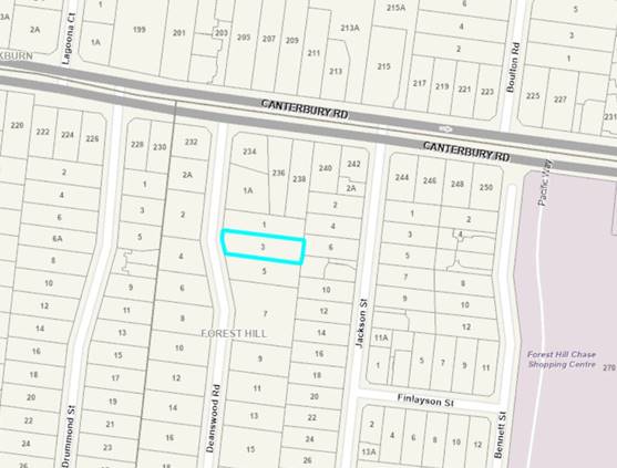
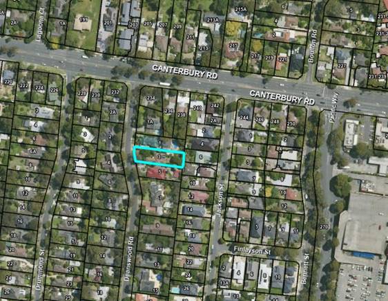
Figure 1 Site aerial view. Blue outlines the subject site.
|
14 Objections received |
é North |
BACKGROUND
Processing Background
Section 57A amendment
A Section 57A amendment was lodged on 25 October 2023 to address issues raised by planning officers. Changes were made to the proposal as follows:
· Alteration of dwelling design detail to incorporate a variety of colours and materials.
· Alter the roof form to incorporate a gable and hipped pitched roof using Colorbond material.
· Retention of Tree 6 within the rear private open space.
Since the notice of the application was undertaken, further plans were submitted to Council prepared by Carter Grange dated 3 February 2024 prior to the forum meeting. This document was submitted responding to issues raised by Planning Officers. The change to the plans includes the following:
· Extension of ground floor roof form along the north and south elevations.
· Amended external materials to first floor walls to rendered cladding.
· Reduction of the first floor built form, including but not limited to:
i. Area reduced from to 210.58m2 160.43m2.
ii. First floor setback increased from 3 to 4 metres from the north boundary.
iii. First floor setback increased from 2.66 to 3.67 metres from the south boundary.
iv. First floor setback increased from 23.24 to 23.25 metres from the east boundary.
v. First floor setback increased from 2.66 to 3.67 metres from the west boundary.
While not formally introduced to the application, the plans will form the below assessment forming the decision.
History
There are no previous planning applications on the subject site.
The Site and Surrounds
The subject site is located on the east side of Deanswood Road, approximately 75 metres south of the intersection with Canterbury Road. The site is generally rectangular in shape with an angled front boundary to the road, with the frontage measuring 17.42 metres to Deanswood Road, a maximum depth of 57.91 metres and comprises an overall area of 946.46 square metres.
The site contains a single storey timber weatherboard dwelling with a tiled hipped roof form. A crossover is located to the northwest corner of the lot with an internal driveway adjacent to the north side boundary. The site has a slope of approximately 3 metres falling from the south-east corner to the north-west corner.
The arborist report submitted with the application, prepared by TMC Reports, dated 27 May 2023, provides an assessment of 26 trees. Trees 6 to 25 are located within the subject site and Trees 1 to 5 and 26 are located within adjoining lots. The following table shows all trees within this report:
Table 1
|
Tree No. |
Species |
Height (m) |
Trunk Circ. At 1m |
Significance (retention value) |
Comments |
|
1 |
Photinia robusta – Red Leaf Photinia |
4.8 |
0.66 |
Low |
Neighbouring tree located within the northern adjoining property (1 Deans Wood Road). Restricted view. Existing carport and garage within TPZ. |
|
2 |
Photinia robusta – Red Leaf Photinia |
7 |
0.63 |
Low |
Neighbouring tree located within the northern adjoining property (5 Deans Wood Road). Located 4m+ from works. |
|
3 |
Pittosporum eugenioides 'Variegatum' - Lemonwood |
9.2 |
0.66 |
Low |
Neighbouring tree located within the northern adjoining property (5 Deans Wood Road). Located 4m+ from works. |
|
4 |
Syzygium smithii - Lilly Pilly |
8 |
1.57 |
Low |
Neighbouring tree located within the northern adjoining property (5 Deans Wood Road). Located within 4m of works. |
|
5 |
Lophostemon Confertus - Queensland Brush box |
8.2 |
1.48 |
Moderate |
Neighbouring tree located within the northern adjoining property (5 Deans Wood Road). Located within 4m of works. |
|
6 |
Lophostemon Confertus - Queensland Brush box |
10 |
0.94 |
Moderate |
With rear secluded private open space on subject site. |
|
7 |
Ligustrum lucidum - Broad-leaf privet |
6 |
0.41 |
Low |
Located adjacent to rear (east) boundary. |
|
8 |
Pittosporum Tenuifolium - James Stirling |
6 |
0.35 |
|
Located adjacent to rear (east) boundary. |
|
9 |
Ligustrum lucidum - Broad-leaf privet |
11.2 |
1.57 |
Low |
Located adjacent to rear (east) boundary. |
|
10 |
Ligustrum lucidum - Broad-leaf privet |
11.3 |
1.04 |
Low |
Located adjacent to rear (east) boundary. |
|
11 |
Photinia robusta - Red Leaf Photinia |
5.8 |
0.44 |
Low |
Located adjacent to rear (east) boundary. |
|
12 |
Syzygium smithii - Lilly Pilly |
5 |
0.22 |
Low |
Located adjacent to side (south) boundary. |
|
13 |
Pittosporum Tenuifolium - James Stirling |
4.6 |
0.25 |
Low |
Located adjacent to side (south) boundary. |
|
14 |
Pittosporum Tenuifolium - James Stirling |
4.2 |
No data |
Low |
Located adjacent to side (south) boundary. |
|
15 |
Callistemon citrinus - Crimson Bottlebrush |
4.7 |
0.41 |
Low |
Located adjacent to side (south) boundary. |
|
16 |
Pittosporum Undulatum – Sweet Pittosporum |
17 |
1.07 |
Low |
Existing dwelling within TPZ. |
|
17 |
Picea sp.– Spruce |
3 |
0.6 |
Low |
Existing dwelling within TPZ. |
|
18 |
Hakea salicifolia – Willow-leaved hakea |
4.5 |
0.53 |
Low |
Co-dominant stems at ground level. |
|
19 |
Callistemon citrinus - Crimson Bottlebrush |
4.6 |
0.31 |
Low |
Located adjacent to the south side boundary |
|
20 |
Pittosporum Tenuifolium - James Stirling |
4.8 |
0.22 |
Low |
Located adjacent to the south west corner. |
|
21 |
Corymbia ficifolia - Flowering Gum |
12 |
1.32 |
Moderate |
Located adjacent to the front (west) boundary. |
|
22 |
Eucalyptus Cephalocarpa - Mealy stringybark |
8 |
0.97 |
Low |
Located adjacent to the front (west) boundary. |
|
23 |
Eucalyptus radiata - Narrow-leaved peppermint |
17 |
2.32 |
Moderate |
Located adjacent to the front (west) boundary. |
|
24 |
Liquidambar Styraciflua - Liquidambar |
10.6 |
1.73 |
Moderate |
Existing dwelling and gravel driveway within TPZ. Low hanging branches to 2m above ground level. |
|
25 |
Mixed sp. – Mixed vegetation |
0.5 |
|
Low |
Group of trees adjacent to the north side boundary. |
|
26 |
Cotoneaster sp. - Cotoneaster |
5 |
0.41 |
Low |
Adjacent to the south side boundary on the adjoining lot (5 Deanswood Road). |
Of the assessed trees, those numbered 1, 4, 5, 16, 17, 18 and 24 are protected under Schedule 2 to the Significant Landscape Overlay.
The subject site is located within a residential area and is located within the Bush Environment, Limited Change Neighbourhood Character area. This area will be described further below.
Within the immediate context, the following is noted:
North
The adjoining lot to the north, at 1 Deanswood Road, contains a single storey rendered brick dwelling with an iron pitched gabled roof. The site also consists of an outbuilding and a swimming pool within the rear. The dwelling is setback 7.6 metres to Deanswood Road and a minimum of 4.1 metres from the common boundary with the subject site. An attached carport structure is located on the shared boundary with the subject site.
South
The adjoining lot to the south, at 5 Deanswood Road, contains a single storey timber weatherboard dwelling with a tiled pitched hipped roof. The dwelling is setback approximately 11.2 metres to Deanswood Road and approximately 4.2 metres to the common boundary with the subject site.
East
The adjoining lot to the east, at 6 Jackson Street, contains a single storey weatherboard dwelling with a gabled iron pitch roof form with an area of secluded private open space (SPOS) orientated towards the subject site.
The other adjoining lot to the east, at 2/8 Jackson Street, contains a single storey dwelling with a tiled hipped roof. The dwelling is setback approximately 3 metres to the boundary with the subject site.
Within the remainder of Deanswood Road, the predominant housing style is single storey detached dwellings with examples of double storey dwellings. Most roof styles are pitched, with some evidence of flat roof forms further towards the south of the street. Dwellings are of mix of brick construction (some with rendered finishes) and weatherboard cladding. The appearance of vegetated garden areas around buildings is a notable feature of the area.
PROPOSAL
The application proposes the construction of a single storey dwelling with associated tree removal. The key features of the proposal include:
· The dwelling is setback between 11.9-14.95 metres to the Deanswood Road boundary, a minimum of 2.66 metres to the south boundary, a minimum of 1.2 metres to the north boundary and 19.41 metres to the east boundary.
· The floor layout provides for an entrance, an open plan kitchen, dining and family room, pantry, one bedroom with bathrooms and ensuite, lounge, laundry and powder room at ground floor. Four bedrooms with WIR’s, leisure room, bathroom and ensuites at first floor.
· Vehicle access is via the existing crossover and proposed concrete driveway to a double-width garage towards to north side boundary.
· A roofed outdoor living area is proposed accessible via the family and dining room.
· A total floor area (including garage, porch and alfresco areas) of 298 square metres.
· A site cut (a maximum of 1 metre) and fill (a maximum of approximately 591mm) to create a level area.
· External materials include weatherboard cladding and rendered cladding to external walls and Colorbond cladding to the gable and hipped roof form.
· A maximum building height of 7.8 metres.
· A site coverage of 38.2 percent.
· A site permeability of 61.8 percent.
· The removal of trees 8, 11, 12, 13, 14, 15, 16, 17, 18, 19, 20, 24 and tree group 25. Only trees 16, 17, 18 and 24 are protected under the overlay.
· The retention of trees 6, 7, 9, 10, 21, 22, 23, as well as the proposed planting of seven (7) Australian native canopy trees and 154 proposed shrubs and ground cover plants throughout the site adjacent to the side boundaries, driveway and dwelling entry areas.
As outlined below, the latest set of plans for the proposal were received by Council on 23 February 2023 prepared by Carter Grange dated 3 February 2024. These will form part of the Attachments.
Planning Controls
Neighbourhood Residential Zone, Schedule 1 (NRZ1)
Under Schedule 1 of the Neighbourhood Residential Zone, a permit is not required to construct a dwelling on a lot with a size of 300 square metres or greater. The lot size is greater than 300 square metres and therefore a planning permit is not triggered under the Zone.
Significant Landscape Overlay, Schedule 2
Under Schedule 2 to the Significant Landscape Overlay (SLO2) a permit is required for the removal of a tree having a single trunk circumference of 0.5 metres or more at a height of one metre above ground level.
A permit is required to remove Trees 16, 17, 18 and 24. A summary of these trees follows:
Table 2
|
Species |
Height (m) |
Trunk Circ. At 1m |
Significance (retention value) |
Comments |
|
|
16 |
Pittosporum Undulatum – Sweet Pittosporum |
17 |
1.07 |
Low |
Existing dwelling within TPZ. |
|
17 |
Picea sp.– Spruce |
3 |
0.6 |
Low |
Existing dwelling within TPZ. |
|
18 |
Hakea salicifolia – Willow-leaved hakea |
4.5 |
0.53 |
Low |
Co-dominant stems at ground level. |
|
24 |
Grevillea robusta – Silky Oak |
10.6 |
1.73 |
Moderate |
Existing dwelling and gravel driveway within TPZ. Low hanging branches to 2m above ground level. |
Source – TMC Reports
Trees 8, 11, 12, 13, 14, 15, 19, 20 and 25 do not trigger a permit for removal due to being under 0.5 metres in trunk circumference (measured 1 metre above ground level).
Under Clause 42.03-2 a permit is also required to undertake buildings and works within four metres of protected trees. Buildings and works are proposed within 4 metres of Trees 1, 4 and 5. A summary of these trees follows:
Table 3
|
Tree No. |
Species |
Height (m) |
Trunk Circ. at 1m |
Significance (retention value) |
Comments |
|
1 |
Photinia robusta – Red Leaf Photinia |
4.8 |
0.66 |
Low |
Neighbouring tree located within the northern adjoining property (1 Deans Wood Road). Restricted view. Existing carport and garage within TPZ. |
|
4 |
Syzygium smithii – Lilly Pilly |
8 |
1.57 |
Low |
Neighbouring tree located within the southern adjoining property (5 DeansWood Road). Very heavily lopped. Pruning does not meet AS4373–2007. Very sparse canopy. |
|
5 |
Lophostemon Confertus – Queensland Brush box |
8.2 |
1.48 |
Moderate |
Neighbouring tree located within the southern adjoining property (5 Deans Wood Road). Heavily pruned. Leaning to the west. Existing dwelling within TPZ. |
Schedule 2 to the Overlay sets out a number of ‘permit triggers’ for buildings and works. These are detailed below.
Table 4
|
Permit requirement |
Measure |
|
A permit is not required to construct a building or construct or carry out works provided all of the following is met: |
|
|
The building is no higher than two storeys or 9 metres. |
The dwelling is no higher than two storeys or 9 metres with a maximum building height of 7.8 metres proposed with 2 storeys. No permit required |
|
The building is set back at least 9 metres from the front boundary for a single storey building or 11 metres for a two-storey building |
The proposed dwelling is setback a minimum of 11.9 metres (ground floor) and 14.1 metres (first floor) from the front boundary. No permit required |
|
The building is set back at least 3 metres from a boundary to a road at least 4 metres wide (other than the front boundary) for a building wall height of no more than 3.6 metres or 3 metres plus half the building wall height if the building wall height is more than 3.6 metres. |
Not applicable |
|
The building is set back at least 1.2 metres from any other boundary for a building wall height of no more than 3.6 metres or 1.5 metres plus half the building wall height if the building wall height is more than 3.6 metres. |
North (side) boundary Ground Floor The dwelling is setback 3 metres to the north boundary. Garage is setback 1.2m from the north boundary. The maximum wall height is 3.6 metres above natural ground level, which complies.
First Floor The dwelling is setback 4 metres to the north boundary.
The wall height is 6.592 metres above natural ground level. A 4.796-metre setback is required. A variation of 0.796m is sought.
East (rear) boundary First Floor The building is setback 23.25 metres from the east rear boundary with a maximum wall height of 5.18 metres.
The minimum setback (4.15 metres) is met.
South (side) boundary Ground floor The dwelling is setback 2.66 metres to the south side boundary. The wall height is 3.639 metres above natural ground level towards the front of the site, requiring a 3.32m setback. A variation of 0.66 metres is sought.
First floor The building is setback 4.67m and 3.67m metres to the south boundary. The wall height is 6.394m & 5.89 metres above NGL. A setback of 4.697 & 4.445 metres is required. A maximum variation of 0.775m is sought. Permit required |
|
The building is less than 33 per cent of the site area at ground level and 25 per cent of the site area at first floor level, excluding hard surfaces and impervious areas. |
The proposed total building site coverage is 298 square metres of the 964.46m2 lot (30.8 percent) at ground level. First Floor level is 162.5m2 (16.85 per cent). No permit required |
|
Comprising hard surfaced and impervious areas (including tennis courts and swimming pools, but excluding buildings) are less than 17 per cent of the site area. |
Hard surfacing is calculated at 79 square metres for the driveway and front porch path (8.2 percent). No permit required |
|
The total area of all buildings and hard surfaces and impervious areas (including tennis courts and swimming pools are less than 50 per cent of the site area. |
The total building and paving hard surface coverage is 374.3m2 – 38.8 percent (measured by Council Officers). No permit required |
Residential Reticulated Gas Service Connection
Amendment VC250, gazetted on 01/01/2024 prohibits residential reticulated gas connections to all new dwellings. Any application associated with the construction of a dwelling from the 01/01/2024 will include the following mandatory condition:
Any new dwelling allowed by this permit must not be connected to a reticulated gas service (within the meaning of clause 53.03 of the relevant planning scheme). This condition continues to have force and effect after the development authorised by this permit has been completed.
This does not apply to the application at hand in this case, as the application and subsequent amendment under Section 57A was lodged prior to 01 January 2024.
CONSULTATION
Public Notice
The application was advertised by mail to the adjacent and nearby property owners and occupiers and by erecting notice to the Deanswood Road street frontage. Following the advertising period, a total of fourteen (14) objections were received.
The issues raised are summarised as follows:
· Contravenes the provisions of the Whitehorse Planning Scheme. Particularly the SLO2 and Clauses 21.05 and 22.04.
· Neighbourhood character:
§ Landscape character.
§ Against the Bush Environment neighbourhood character guidelines.
§ Bulk and scale, overdevelopment (out of character).
§ Colours and materials proposed.
· Tree removal – Tree 24.
· Loss of vegetation (trees and other vegetation) and inadequate replacement planting/landscaping.
· Major encroachment into Tree Protection Zones.
· Overlooking.
After the S57A amended plans were submitted, they were advertised, and two (2) further objections were received. Also, two (2) objections were withdrawn, maintaining a total of 14 objections. These submissions reiterated objections detailed above including:
· Against the Bush Environment neighbourhood character guidelines.
· Bulk and scale, overdevelopment (out of character).
· Major encroachment into Tree Protection Zones.
· Inadequate type of new trees proposed for landscaping.
Prior to the consultation forum meeting, further plans were received by Council. The plans prepared by Carter Grange dated 3 February 2024 show a reduction in the first floor footprint. As these plans have not been formally amended, the amendments will form part of conditions should a permit be granted.
Consultation Forum
A Consultation Forum was held on 26 March 2024 with Councillors, planning officers and six (6) objectors attended the meeting. The objector issues were discussed at length; however no consensus was achieved during the meeting.
REFERRALS
External
The application was not required to be referred under Section 55 of the Act to any relevant external departments in accordance with Clause 66 of the Whitehorse Planning Scheme.
Internal
Planning Arborist
Council’s arborist has assessed the application and provided the following response to the protected trees:
Trees 16, 17 and 18
I have no objection to their removal. All species are common low arboricultural retention value trees (please refer to the data in the applicant’s arborist report) and can be easily replaced once removed. In addition, their removal is unlikely to have an adverse impact on the landscape character, provided replanting is undertaken.
Tree 24
I have no objection to the removal of this tree. It is a tree of moderate arboricultural retention value. It is an exotic species that is renowned for their problematic and extensive root systems that can cause considerable damage to nearby structures, therefore, in my opinion, not significant enough a specimen to warrant modifying the proposed plans to accommodate the tree.
Provided replanting is undertaken their removal is unlikely to have an adverse impact on the landscape character, long-term.’
In terms of works within four metres of protected trees, the following assessment was provided:
The plans show the areas of encroachment into the TPZs of these trees are:
· Tree 1 – 11.0% not 2.5% (proposed top of batter & within SRZ, major encroachment).
· Tree 4 – 6.8% (proposed top of batter/retaining wall cut, not within SRZ, minor encroachment).
· Tree 5 – 20.0% (proposed dwelling footprint, site cut, not within SRZ, major encroachment) Existing dwelling is a 26% TPZ encroachment.
Based on the levels of encroachment into the TPZs of these trees, with conditions the proposal can be supported. Please see conditions below.
Urban Greening Officer
The application was referred to Councils Urban Greening Officer (formally Tree Education Officer), who reviewed the landscape plan. Overall, the plan was seen as a well-designed layout with appropriate extent of screening plants and tree locations proposed. Concern was raised regarding maintaining the lawn area of the front setback under the dense tree canopy and recommended further landscaping of shrubs and ground covers, due to the site being in the SLO2. The following modifications have been recommended:
· ‘The addition of a garden bed around the base of the existing trees at the front with a mix of indigenous and native shrubs such as more Grevilleas and Lomandra as well as Hop Goodenia, Correa and Dianellas. This should be easier to manage than lawn under dense canopy.
· Along the back fence the addition of an informal row of screening plants such as Hop Wattle, River Wattle, Tea-tree and Sweet Bursaria planted relatively close together (approx. 1.5m)
· I would take this opportunity to remove the Ligustrums. While they form a dense canopy, the berries are bird dispersed and have the potential to threaten parkland and their retention will impact the time which it will take more useful plants to establish.’
Council’s Urban Greening Officer is supportive of the absence of lawn within the front setback where under Trees 21-23, as this will allow for a greater diversity of plants. Given that these large sized trees are to be retained, it has also been recommended that ground underneath this area would both be easier to maintain and would also enhance the bush environment character from the street, with the presence of vegetation at ground level.
To further enhance the bush environment setting, it is recommended garden beds proposed around trees 21-23 within the front setback, with lawn removed and replaced with further ground cover and shrub planting.
These modifications to the landscape plan will be addressed via permit conditions.
DISCUSSION
Response to Planning Policy Framework
The central issue surrounding this application focuses on whether the proposal responds to the landscaping objectives and preferred bush environment landscape character outlined under the Significant Landscape Overlay, Schedule 2 (SLO2), which in this area seeks minimal change in a landscape dominant setting.
This is considered a sensitive area of the municipality in terms of landscape, where this overlay aims to identify these types of areas. This control is aiming to protect and conserve the character of these landscapes. This area falls within this overlay due to the recognition of the quality of the environment which includes large native and dense vegetation.
The Statement of Nature and Key Elements of Landscape for the bush environment area is summarised as follows:
· ‘The significance of the area is attributed to the quality of the environment, which includes vegetation notable for its height, density, maturity and high proportion of Australian native trees. This in turn contributes to the significance of the area as a valuable bird and wildlife habitat’.
The following provides an outline of the relevant local planning provisions.
Clause 21.06 (Housing) is informed by Council’s Housing Strategy 2014. Under this clause, the subject site is located within a ‘Limited Change Area’ when considering the built form in residential areas.
Clause 22.03 (Residential Development) seeks to ensure new development reflects the minimal change designation of housing policy and contributes to the preferred character for this area under the Bush Environment precinct.
Clause 22.04 (Tree Conservation) encourages new development to minimise the loss of significant trees and promotes regeneration of trees by ensuring sufficient space exists on new development for re-planting of a suite of landscaping.
The proposed development would replace one single storey dwelling with one double storey dwelling, while retaining a number of native trees and proposed new vegetation on the site. The building’s scale and siting as well as the vegetation retention and replacement planting would adequately respond to the above policies and the landscape character objectives outlined within the SLO2, which will be discussed further below.
Response to Landscape Objectives
The SLO2 includes a number of landscape objectives to be achieved, which are summarised as follows:
· To retain the dominance of vegetation cover in keeping with the bush character environment.
· To encourage the retention and regeneration of native vegetation for the protection of wildlife habitat.
· To ensure that a reasonable proportion of a lot is free of buildings to provide for the planting of tall trees in a natural garden setting.
· To encourage the development of sympathetic buildings within an envelope, which ensures the maintenance of a tree-dominated landscape.
· To ensure that buildings and works retain an inconspicuous profile and do not dominate the landscape.
· To ensure that development is compatible with the character of the area.
The proposal would allow for an appropriate landscape response particularly within the streetscape of Deanswood Road and the rear of the site, with the retention of large trees on site and the replacement of additional trees and understorey shrubbery. The landscape response continues to both maintain and further enhance the bush environment characteristics of the site, supporting the dominance of vegetation cover in the immediate environment.
In addition, the building has been designed to sit comfortably within this landscape setting. Using appropriate setbacks at both ground and first floor to all boundaries has been considered. Also, the works provide an appropriate design response in terms of materiality, articulation and roof form. This would maintain an inconspicuous profile within the streetscape and adjoining interfaces to avoid being a dominant element in its immediate context.
It is considered the proposed side setbacks to the north and south interface is acceptable and not an unreasonable design to the adjoining interfaces. The building would sit within an envelope located centrally within the subject site. The ground and first floor walls face adjoining buildings and can accommodate consistent landscaping through these boundaries to provide vegetation up to 3 metres high along these boundaries to provide a buffer between adjoining buildings.
The works would sit within the retained vegetation, which can also be found on adjoining lots adjacent to these side boundaries. This provides adequate landscape buffers. The decision plans would allow the built form to be recessed at first floor to ensure an inconspicuous profile is achieved and not unreasonable dominating the landscape. The proposed built form would respect the existing secluded private open space areas to the north, south and east interfaces to adjoining land.
The proposal adequately responds to the landscape objectives of the Significant Landscape Overlay – Schedule 2.
Response to Tree Removal and Landscaping
The application seeks approval for the removal of a number of trees across the site. For the most part, the trees across the site are exotics and examples of environmental and or woody weed species. As assessed above, Council’s Arborist states these trees are readily replaceable with native canopy planting to further respond to the landscape objectives of the Overlay, and the preferred landscape character of the Bush Environment character area.
In relation to Tree 24 (Liquidambar styraciflua - Liquidambar), whilst the tree and its canopy is partially visible within the streetscape and provides a moderate amenity value, Council’s arborist has confirmed it is not worthy of retention in this case given its exotic species type and problematic growth characteristics near buildings.
It is further considered the location of this tree would be problematic for the proposal given its position on the site. The dwelling is adequately setback to meet the SLO2 buildings and works exemption. The dwelling would require to be relocated further towards the rear, closer to sensitive interfaces. This includes the rear secluded private open spaces to adjoining land. However, given the tree’s location within the proposed driveway, garage and porch/entry areas of the proposed dwelling, it is considered the tree is likely to cause long term issues to buildings if retained. Additionally, its retention would likely result in the built form pushing away from its proposed centrally located footprint adjacent to the rhythm of buildings within Deanswood Road.
The retention of established native trees and proposed landscaping of additional native trees throughout the site on balance would provide an adequate response to the bush environment area. Despite the loss of this tree, on balance the site would enhance the native tree canopy cover within the landscape.
Despite the proposed tree removal, there are also several native established trees being retained, which can be successfully incorporated into the development. The following trees are proposed for retention:
· Tree 6 is a 10 metre high Lophostemon confertus – Queensland Brushbox tree located centrally in the rear open space of the site.
· Tree 21 is a 12 metre high Corymbia ficifolia – Flowering Gum, located within the front setback of the site.
· Tree 22 is a 8 metre high Eucalyptus cephalocarpa – Mealy Stringybark located within the front setback of the site; and
· Tree 23 is a 17 metre high Eucalyptus radiata – Narrow leaved peppermint located within the front setback of the site.
The applicant’s arborist has assessed these trees with a useful life expectancy (ULE) of 20 plus years. These trees, as individual specimens and as a grouping, will continue to provide a very high contribution to the landscape character. This existing tree canopy within the frontage would assist to screen the proposed dwelling from the street and will maintain the continuation of tree canopy linking with surrounding trees.
The decision guidelines within the SLO2 recommend an average density of one tree (reaching a height) of over 15 metres to each 150 square metres of site area. This equates to eleven trees within the site. The landscape plan specifies seven trees for planting within the site, consisting of three (3) Acacia implexa – Lightwood, two (2) Eucalyptus leucoxylon macrocarpa ‘Rosea’ – Yellow Gum and two (2) Eucalyptus polynathemos – Red Box, which would provide a total of 14 trees (including the retention of Trees 6, 7, 9, 10, 21, 22 and 23).
Tree 23 already exceeds a height of 15 metres and Trees 21 and 22 are between eight and twelve metres and have the potential to reach a height of 15 metres. The specified trees within the landscape plan have potential to reach a mature height of 15 metres and is considered to adequately meet the expectations of providing native and indigenous species on the site, and as such, responding to the preferred bush environment landscape character.
To enhance the landscaping within the site, particularly within the frontage, further shrubs and ground covers would be incorporated to regenerate the lower-level vegetation within the site. This provides an adequate landscaping response within the street to retain vegetation dominance within this sensitive area.
As previously discussed, this has been addressed by way of conditions, in accordance with recommendations from Council's Urban Greening Officer.
Objectors Concerns not Previously Addressed
The proposal contravenes the purpose and objectives of the applicable planning policy.
There are exemptions that have not been met and require assessment under this SLO2 control. It is noted not meeting this exemption does not prohibit the proposal. However, this is the permit trigger and can be assessed for support where appropriate. This includes the northern and southern (side) setbacks and works near trees protected under the provisions of the SLO2 control. The assessment above demonstrates the proposal is acceptable.
Consistency with neighbourhood character objectives.
The proposed development is for the double storey detached dwelling with a pitched roof form and reduced first floor footprint as shown on decision plans to achieve a responsive design to adequately fit into the area. It is acknowledged the street has a variety of both single and double storey buildings. The front setback and overall building height meets the minimum exemption in the Significant Landscape Overlay and the side and rear setbacks are adequate to allow for abundant planting opportunities.
Lack of replacement tree planting and overall landscaping opportunity
The proposed development is able to accommodate seven (7) additional canopy trees onsite and seeks to retain seven (7) trees. 11 of the trees would be Australian native species which have potential to meet a medium to large canopy on the site. In addition, further landscaping of garden beds, increased shrubs and ground covers throughout the site, particularly toward the street frontage would form conditions on the permit.
Impact to trees within adjoining lots.
There are no unreasonable impacts to trees on adjoining lots. This has been confirmed by Council’s Arborist. Trees would incur a minor encroachment from the works, or a reduced major encroachment from the existing buildings on the subject site. Tree protection conditions, including specific conditions to include a Tree Protection and Management Plan, have been recommended and will form part of the permit.
Overlooking
The application is not assessed against the requirements of ResCode standards, including overlooking because it is not a consideration under the SLO2.
CONCLUSION
The proposal for the construction of one (1) dwelling on a lot and removal of vegetation within the Significant Landscape Overlay – Schedule 2, is an acceptable response that satisfies the relevant provisions contained within the Whitehorse Planning Scheme.
The provision of one double storey dwelling, which replaces a single storey dwelling, will provide an appropriate response to the landscape character, including the objectives of the Significant Landscape Overlay, Schedule 2. The new dwelling will provide for appropriate development that ensures its built form responds to the landscape, front setback, rear setback and around the perimeter of the site can be well vegetated, and in doing so, will be consistent with the landscaping in the street. The space around the new building allows for an extent of landscaping, for tree retention, new tree planting and landscaping to ensure the built form appropriately fits into the landscape and the vegetated character is retained and enhanced.
A total of fourteen (14) objections were received as a result of public notice and all of the issues raised have been discussed as required.
It is considered that the application should be approved.
Attachment
1 Amended Decision
Plans Attachment 1-3 ![]()
2 Landscape Plan -
Attachment 2 - 3 Deanswood Road, Forest Hill ![]()
3 Advertised Plans -
Attachment 3 - 3 Deanswood Road, Forest Hill ![]()
Attendance:
Mayor, Cr Massoud returned to the chamber at 8.45pm and resumed the role as chair.
10.2 8 Glengarry Avenue, Burwood (LOT 23 LP 27631 17) - Construction of two double storey dwellings, removal of protected trees and buildings and works within four (4) metres of protected trees
|
Department |
City Planning and Development Director City Development |
Attachment
SUMMARY
This planning permit application proposes the construction of two (2) double storey dwellings, removal of protected trees and buildings and works within 4 metres of protected trees. The application triggers a planning permit pursuant to the provisions of the General Residential Zone, Schedule 3 and the Significant Landscape Overlay, Schedule 9.
This application was advertised, and a total of 12 objections were received. The objections raised issues with amenity, neighbourhood character, car parking and traffic, landscaping, site operation, and other impacts.
In response to concerns raised by Council Officers and objectors, amended sketch plans were submitted by the applicant for discussion purposes.
These plans include the following key changes from the plans originally advertised:
• Dwelling 1 floor area of the ground floor is reduced to 116.7 square metres (including garage) with the nominated secluded private open space (SPOS) relocated to the west of the living area.
• Dwelling 1 floor area of the first floor is reduced to 64.7 square metres with increased setback from the western boundary towards to the north/rear of the dwelling.
• Dwelling 1 garage located further towards the west with western boundary setback reduced to 3.8 metres.
• Dwelling 1 garage is attached to the Dwelling 2 to the north and the development now has conjoined ground floor.
A Consultation Forum was held on online via Zoom on 16 November 2023 chaired by Councillor Cr Davenport and attended by objectors, planning officers and the applicant. A copy of the amended sketch plans was circulated and discussed at the Forum. During the forum, the above issues were explored, however no resolution was reached between the parties.
The application has been referred to Council internal departments for comments.
Council’s arborist has supported the proposed removal of the trees as well as buildings and works within 4 metres of protected trees subject to conditions. Council’s Transport Engineer has reviewed the proposed development and raised issues regarding swept path diagrams for vehicular access to and from Dwelling 2 garage to be addressed by conditions should a permit issue.
This report assesses the application against the relevant provisions of the Whitehorse Planning Scheme, as well as the objector concerns. It is recommended that the application be supported, subject to conditions.
|
Moved by Cr Barker, Seconded by Cr Munroe That Council:
For: Cr Barker, Cr Carr, Cr Cutts, Cr Lane, Cr Liu, Cr Massoud, Cr McNeill, Cr Munroe, Cr Skilbeck, Cr Stennett (10) Against: Cr Davenport (1) |
|
Applicant: PBD Group Pty Ltd Zoning: General Residential Zone, Schedule 3 (GRZ3) Overlays: Significant Landscape Overlay, Schedule 9 (SLO9) Development Contributions Plan Overlay, Schedule 1 (DCP1)
Relevant Clauses: Clause 11 Settlement Clause 12 Environment and Landscape Values Clause 15 Built Environment and Heritage Clause 16 Housing Clause 18 Transport Clause 21.05 Environment Clause 21.06 Housing Clause 22.03 Residential Development Clause 22.04 Tree Conservation Clause 32.08 General Residential Zone, Schedule 3 Clause 42.03 Significant Landscape Overlay, Schedule 9 Clause 45.06 Development Contributions Plan Overlay, Schedule 1 Clause 52.06 Car Parking Clause 53.18 Stormwater Management in Urban Development Clause 55 Two or More Dwellings on a Lot Clause 65 Decision Guidelines
Ward: Wattle |
![]()

Figure 1 Site aerial view. Blue outlines the subject site.
|
12 Objections received |
é North |
BACKGROUND
There has been one previous Planning Permit application (WH/2020/1006) for the construction of two (2) dwellings in side-by-side arrangement with one (1) additional crossover onto Glengarry Avenue with associated tree removal. The application was subsequently withdrawn by the applicant and did not proceed to a decision.
In relation to the current Planning Permit application (WH/2022/840), the application was lodged on 30 September 2022, and amended plans were submitted pursuant to Section 50A of the Planning and Environment Act 1987 (The Act) on 28 November 2022. After the public notification process, plans were amended on 29 March 2023 and subsequently on 14 September 2023 in response to concerns raised by planning officers. These plans include the following key changes to Dwelling 1 from the plans originally advertised, including:
· The floor area of the ground floor is reduced to 116.7 square metres (including garage) with the nominated secluded private open space (SPOS) relocated to the west of the living area.
· The floor area of the first floor is reduced to 64.7 square metres with increased setback from the western boundary towards to the north/rear of the dwelling.
· The garage located slightly towards west with western boundary setback reduced to 3.8 metres.
· The garage is attached to the Dwelling 2 to the north and the development now has conjoined ground floor.
The amended sketch plans, dated 14 September 2023, will be referred as ‘the submitted plans’ and will be used for discussion purpose in this report, and will be given effect through permit conditions, should Council form a view to issue a permit.
The Site and Surrounds
The subject site is located on the north side of Glengarry Avenue in Burwood with a bend on the road located immediately to the west of the frontage. The site is irregular in shape (smaller frontage and wider rear) with a frontage of 13.69 metres, rear boundary of 24.38 metres, a maximum depth of 41.34 metres and comprises an overall site area of 743 square metres.
The subject site contains a single storey dwelling with a mixed brick and rendered finished façade with a pitched roof form. Vehicular access is provided via a driveway and crossover along the eastern side boundary with a double garage to the southeast of the dwelling. A 1.83-metre-wide easement is located along the northern/rear boundary. There is native and exotic vegetation across the site with canopy trees located in both the front and back yard.
There is a cross-fall in a north-south direction of approximately 1.92 metres throughout the site. It has a slight slope from the northern boundary to the front of the dwelling, and a relatively more pronounced fall from the dwelling to the frontage towards the southwest corner. There is an existing brick retaining wall located along the frontage between the western side boundary and the driveway. The site has an open appearance to the street with no front fencing.
The site is located within a residential area that contains a mix of remnant housing stock, single and double storey brick dwellings, and some new infill development. Within the immediate context, the following is noted:
· 10 Glengarry Avenue is located to the west of the site and contains a single storey dwelling with a mix of brick and weatherboard façade. The dwelling is setback 8.04 metres to the frontage and 0.98 metres from the shared boundary with the subject site. There are a number of habitable room windows within 3 metres facing east towards the subject site. Vehicle access is via a driveway along the western boundary to the single garage at the back.
· 6 Glengarry Avenue is located to the east of the site and is developed as a single storey brick building for a rooming house. The building is setback 8.47 metres to the front boundary and 1.57 metres from the shared boundary with the subject site. There are a number of habitable room windows facing west towards the subject site. Vehicle access is via a driveway at the southeast corner of the property frontage.
· 177 Station Street is located to the north of the site and is developed as Box Hill Motel.
The subject site is located proximate to parks, services, public transport, and local shops including Gardiners Creek Reserve, Deakin University, tram routes operating along Burwood Highway, bus routes operating along Station Street, and the Bennettswood shopping centre.
Planning Controls
Permit Triggers
General Residential Zone – Schedule 3
In accordance with Clause 32.08-6 (General Residential Zone, Schedule 3) of the Whitehorse Planning Scheme, a permit is required for the construction of two dwellings on a lot. Schedule 3 to the Zone outlines a number of variations to the requirements of ResCode (Clause 55), including variations to B8 (Site coverage), B9 (Permeability), B13 (Landscaping), B17 (Side and rear setbacks), B18 (Walls on boundaries), Standard B28 (Private Open Space) and B32 (Front fences).
Clause 32.08-4 outlines the minimum garden area requirements for an application to construct a dwelling. As the site has an area of 743 square metres, a total garden area of 35 per cent is required. The submitted plans demonstrate a total garden area of 343.4 square metres (or 46.22 per cent) thus exceeding the 35 per cent mandatory requirement. Therefore, the proposal meets the minimum garden area requirement pursuant to Clause 32.08-4.
Clause 32.08-11 outlines the maximum building height requirement for a dwelling being 11 metres, and the building must contain no more than 3 storeys at any point. A building may exceed the maximum building height by up to 1 metre if the slope of the natural ground level, measured at any cross section of the site of the building wider than 8 metres, is greater than 2.5 degrees. The proposal demonstrates both dwellings will be two storey and will not exceed 11 metres in height when measured from the ground level, and as such the proposal meets the maximum building height requirement pursuant to Clause 32.08-11.
Significant Landscape Overlay – Schedule 9
In accordance with Schedule 9 to Clause 42.03-2 (Significant Landscape Overlay, Schedule 9) a permit is required to destroy, remove, or lop a tree.
A protected tree is measured as a height of at least 5 metres or a single trunk circumference of at least 1 metre. Schedule 9 provides exemptions in some circumstances, including but not limited to:
· A tree that is listed an environmental weed species as per the specified list;
· A tree is less than 3 metres from the wall of an existing Dwelling or an existing Dependent Person's Unit;
· A tree which is dead or dying or has become dangerous to the satisfaction of the responsible authority.
In accordance with Schedule 9 to Clause 42.03-2 a permit is also required to construct a building or construct or carry out works for:
· A front fence that is within 4 metres of any vegetation that requires a permit to be removed.
· Construction a building or carrying out works within 4 metres from the base of any tree protected under the provisions of Schedule 9.
The application proposes the removal of a number of trees on the subject site of which two (2) will require a planning permit. It is also proposed to carry out buildings and works within 4 metres of trees protected on site and adjoining properties.
The submitted arborist report, prepared by ArborReport Victoria and dated 14 November 2022, provides an assessment of 10 trees, including seven (7) on the subject site, one (1) on the neighbouring property and two (2) street trees. See below table for details. Please note the numbering of trees in the arborist report will be used for discussion purpose in this report.
Table 1 – Tree assessment table
|
Tree # |
Species |
Common name |
Height |
Spread |
Retention Value |
Is a Permit required under the SLO9? |
|
1 |
Pyrus usuriensis |
Manchurian Pear |
7m |
5m |
Low |
Yes, removal |
|
2 |
Pyrus usuriensis |
Manchurian Pear |
6m |
5m |
Low |
Yes, removal |
|
3 |
Pyrus usuriensis |
Manchurian Pear |
4.5m |
1m |
Low |
No |
|
4 |
Ficus microcarpa var. hillii |
Hills’ Weeping Fig |
3m |
2-8m |
Low |
No |
|
5 |
Magnolia 'Little Gem" |
Magnolia |
3m |
2-10m |
low |
No |
|
6 |
Quercus robur |
English Oak |
13m |
15m |
high |
Yes, buildings and works within 4m |
|
7 |
Camellia japonica |
Camellia |
2m |
2m |
low |
No |
|
8 |
Magnolia denudate |
Magnolia |
4m |
2-3m |
high |
No |
|
9 |
Acacia implexa |
Lightwood |
6m |
5m |
High (street tree) |
No |
|
10 |
Prunus x blireiana |
Flowering Cherry Plum |
5m |
5m |
High (street tree) |
Yes, buildings and works within 4m |
Other Planning and Related Controls
Clause 45.06 - Whitehorse Development Contributions Plan
Amendment C241whse to the Whitehorse Planning Scheme, gazetted on 21 December 2023, implements the Whitehorse Development Contributions Plan (Whitehorse DCP).
The subject site is within ‘Area 12 Burwood’ charge area. Given there is only one (1) existing dwelling on the lot, the proposal being two (2) dwellings on the subject site, will result in a net increase in demand unit from the additional one (1) dwelling.
Therefore, should a permit be issued, conditions would be required to address both development infrastructure and community infrastructure levies pursuant to Schedule 1 to Clause 45.06.
Clause 52.03 - Residential Reticulated Gas Service Connection
Amendment VC250, gazetted on 1 January 2024 prohibits residential reticulated gas connections to all new dwellings. Any application associated with the construction of a dwelling from the 1 January 2024 will include the following mandatory condition:
Any new dwelling allowed by this permit must not be connected to a reticulated gas service (within the meaning of clause 53.03 of the relevant planning scheme). This condition continues to have force and effect after the development authorised by this permit has been completed.
This amended application pursuant to Section 50A of the Act was lodged on 28 November 2022, which was before the approval date of Amendment VC250. Therefore in accordance with Clause 53.03-5 of the Whitehorse Planning Scheme the above condition does not apply.
Clause 52.06 – Car parking
Pursuant to Clause 52.06-5, the application must be provided with four (4) resident car parking spaces and meet the relevant design standards for car parking.
Cultural Heritage Management Plan (CHMP)
The entire site is subject to cultural heritage sensitivity map. Pursuant to Section 9 of the Aboriginal Heritage Regulation 2018, development of two dwellings is an exempt activity, and therefore a Cultural Heritage Management Plan (CHMP) is not required.
PROPOSAL
The application proposes the construction of two (2) double storey dwellings, removal of protected trees, and buildings and works within 4 metres of protected trees pursuant to the Significant Landscape Overlay, Schedule 9 (SLO9).
Overall Development
The application seeks the development of the land for two dwellings with pitched roofs in tandem arrangement with Dwelling 1 fronting onto Glengarry Avenue and Dwelling 2 located at the rear. The development has a maximum overall building height of 7.595 metres (measured from Dwelling 1 south elevation) and the site coverage of 46.22 per cent. The proposal will utilise the existing crossover with a shared driveway proposed along the eastern boundary to provide vehicle access to and from Glengarry Avenue. There is no front fence proposed, but a new retaining wall with a maximum height of 0.75 metres is proposed along the Glengarry Avenue frontage. Key features of each dwelling are:
Dwelling 1
Dwelling 1 is positioned to the front of the site and is oriented towards Glengarry Avenue. A double garage is located behind the dwelling, and access to the garage is via the proposed shared driveway to the east.
The proposed ground floor contains the main entry point, a guest bedroom with an ensuite, open plan kitchen, dining and living areas, and a laundry. The dining and living areas open onto a secluded private open space area of 35.04 square metres with minimum dimension of 5 metres located directly to the west of the dwelling, with additional open space to the northwest of the dwelling to the west of the garage. The proposed first floor contains three (3) bedrooms, including a large master bedroom with ensuite.
For external materials, the ground floor will be brick walls, and the first floor wall will be rendered and the roof will be tiled.
Dwelling 2
Dwelling 2 is located approximately 23.26 metres to the Glengarry Avenue frontage and is positioned behind Dwelling 1. The ground floor is attached to the garage of Dwelling 1 to the south and there is 4.1 metres separation distance between the first floor. The proposed double garage is located at the end of the shared driveway to the east of the Dwelling 2.
Similar to Dwelling 1, it contains a guest bedroom with ensuite, open plan kitchen, dining and living areas, and a laundry on the ground floor, a decking directly to the north, and a secluded private open space area of 165.9 square metres located to the west that is accessible from the living area. There are three bedrooms, one ensuite, bathroom and a retreat on the first floor.
The external wall materials and colours are similar to Dwelling 1.
Tree removal – protected under the SLO9
Of the nominated trees within the site boundaries, two (2) trees (or group of trees), marked as Trees 1 and 2, require a planning permit for removal under the SLO9, which are described as follows (derived from the arborist report):
|
Tree # |
Species |
Common name |
Height |
Spread |
Retention Value |
|
1 |
Pyrus usuriensis |
Manchurian Pear |
7m |
5m |
Low |
|
2 |
Pyrus usuriensis |
Manchurian Pear |
6m |
5m |
Low |
Buildings and works within four (4) metres under the SLO9
It is proposed to carry out buildings and works within four (4) metres of protected trees 6 and 10, which is summarised as follows:
|
Tree # |
Species |
Common name |
Location |
TPZ encroachment |
Buildings and works |
|
6 |
Quercus robur |
English Oak |
Backyard, northwest corner |
14.6%, which is major encroachment in accordance with 4970-2009. |
Northwest section of Dwelling 2 |
|
10 |
Prunus x blireiana |
Flowering Cherry Plum |
Street tree |
0% |
Retaining walls along frontage |
CONSULTATION
Public Notice
The application was advertised by mail to the adjacent and nearby property owners and occupiers and by erecting notices to the Glengarry Avenue frontage. Following the advertising period 12 objections were received.
The issues raised are summarised as follows:
Amenity impacts:
· Overlooking.
· Overshadowing.
Neighbourhood Character:
· Building bulk and form.
· Black brick cladding is out of character.
Car parking and traffic:
· Increased on-street parking.
· Traffic safety impacts on the street.
Landscaping:
· Tree removal.
· Impacts to retained Oak tree.
· Insufficient landscape areas.
Site operation:
· Inadequate waste facilities (bin storage inconvenient, requiring bins to be moved through the garage).
· Clothesline locations are not convenient to laundries.
Potential rooming house:
· The site is currently used as a rooming house, which is creating parking, waste issues on the street.
· The street currently accommodates a high number of rooming houses.
Documentation errors:
· Site area is inconsistent between the plans and survey plan.
· Dimensioned distances do not match scaled (such as driveway width).
· Permeability figure appears inaccurate.
Non-planning matters:
· Set an undesirable precedent.
· Water runoff to adjacent lots.
In response to Council and objector concerns, the applicant submitted the amended sketch plans referenced above. These plans were circulated to all submitters prior to the Forum for discussion purposes.
Consultation Forum
A Consultation Forum was held online via Zoom on 13 December 2023 chaired by the Ward Councillor – Councillor Davenport. Several objectors, the applicant, and a statutory planning team leader and two planning officers attended the meeting. The specific issues advanced within the Consultation Forum are generally consistent with the objections raised, with further details documented below:
Neighbourhood character discussion
· Proposal is inconsistent with garden suburban characteristics
· Dominance in the street due to street back (B6 issue)
· Removal of trees, including health and longevity of the oak tree at the rear
· Tree 6 on plans, and to be retained, how are the foundations constructed to be tree sensitive
· Tree pruning to facilitate the dwelling, will this impact the structure of the tree
· Response to urban forest strategy
· What does the paving sit under - what areas are permeable
· Conditions for site cut / fill around tree
Amenity concerns
· Double storey dwelling development is the intent, primarily for rental
· The existing dwelling has been using as student accommodation and with excessive number of cars parking on site and on street
· 4 primary impacts, including:
- Views into living area and vice versa, overlooking (would there be an option for another treatment option for screening (external screen would be required plus screening vegetation
- Rear yard character response inconsistent with previous approval
- Increased shadow to bedrooms within the frontage
- Impact on street parking
· Opportunity to relocate AC units (and other services) to minimise noise and amenity impacts
Traffic and parking
· Inadequate provision of parking allocated to each dwelling
· Increased potential for overflow parking in the street
· Due to bend in frontage, challenging to fit cars in, obstructs views of motorists and cyclists
· Location of bins, awkward to take bins out to street
· Is the car parking spaces enclosed, brick / paling fence, notation on plans
Inaccuracies on plans
· Inconsistency between garages has been considered and acceptable
· Results in potential inaccuracies when calculated against the Scheme
· How to calculate garden area, permeability and the like
· Notation of tree to be retained
· Check title / survey against site plan
· Duplication of areas
· Inadequate internal amenity
· Garage clearances to be shown
· Careful consideration of percentage coverages when assessing applications
REFERRALS
External
No external referrals were required. The application does not require referral under the requirements of the Whitehorse Planning Scheme.
Internal
Transport Engineering
The application has been referred to Council’s Transport team. Concerns have been raised regarding the swept path analysis for the vehicular access entering and exiting Dwelling 2 garage. Council’s Transport Engineer provided advice that the swept path functionality of the proposal in the originally advertised plans was not acceptable, with vehicles required to undertake multiple corrective manoeuvres in order to enter or exit respective spaces.
Planning Arborist
The application has been reviewed by Council’s arborist who raised no objections to the proposal, subject to conditions. Specifically, Trees 1 and 2 are common and can be easily replaced once removed, and encroachment into the TPZ of Tree 6 can be managed subject to conditions.
DISCUSSION
Consistency with Policy Framework
Planning Policy framework
Clause 11.02-1S (Supply of urban land) emphasises opportunities for the consolidation, redevelopment and intensification of existing urban areas near activity centres and public transport, while respecting neighbourhood character and landscape values. Clause 15.01-1S (Urban design) requires development to respond to its context and also highlights the need for landscaping that supports the amenity, attractiveness and safety of the public realm.
Clause 15.01-2S (Building design) includes an objective to ‘achieve building design and siting outcomes that contribute positively to the local context, enhance the public realm and support environmentally sustainable development.’
Clause 15.01-5S (Neighbourhood character) seeks to ‘recognise, support and protect neighbourhood character, cultural identity, and sense of place’, including various strategies.
Local Planning Policy Framework
Clause 21.05 (Environment) seeks to ensure that the important environmental qualities of the City of Whitehorse are protected through retention of canopy trees, protection and enhancement of neighbourhood character elements that make residential areas liveable.
Clause 21.06 (Housing) seeks to further the vision of ensuring that housing meets residents’ needs. The subject site is contained in the natural change area, which is described as follows:
Natural Change areas allow for modest housing growth and a variety of housing types provided they achieve the preferred future neighbourhood character as identified in Clause 22.03 – Residential Development.
Clause 22.03 (Residential Development) applies to all applications for development within the City of Whitehorse and is intended to guide preferred development outcomes in terms of location, character and built form. The subject site is identified as ‘Garden Suburban 4’ character area.
Clause 22.04 (Tree Conservation) aims to identify and recognise the importance of tree conservation within the municipality, and ensure new development retains the existing trees and enhances the landscape amenity of residential areas.
Upon review the above planning policies, the proposal shows consistency with the policy objectives by demonstrating that:
· The subject site is in a location with good access to services, including Deakin University, and public transport. Clause 16 and 21.06 encourage housing growth in such location provided the preferred future neighbourhood character is achieved. Clause 21.06-3 supports increased housing choice by allowing for a diversity of dwelling types, sizes and tenures. The design response respects the existing character of the area, with appropriate siting, setbacks, spacing and landscaping outcomes.
· The design response contributes to the preferred neighbourhood character of the area, with appropriate setbacks, building articulation, architectural style, pitched roof form, materials (i.e. brick, render and tiled roof) that respect the outcomes sought within the ‘Garden Suburban 4’ character area.
· The design response ensures that sufficient space is available to the frontage, side and rear boundaries respecting the setback characteristics of the area, and ensuring sufficient setbacks to plant landscaping and improve the landscape character of the area. in addition, the proposal also includes retaining the existing canopy tree in the backyard. The retention of vegetation together with the landscaping opportunities as part of the new development will ensure the landscape character of the area is enhanced.
· The proposal is responsive to the site context and constraints of the land to avoid dominance of the built form within the landscape character, by ensuring dwelling design follows the topography of the site and minimises elevated floor levels.
Design and Built Form
Specific to the ‘Garden Suburban 4’ character area expressed at Clauses 21.06 and 22.03, the proposal demonstrates consistency with the strategies and preferred character objectives on the following grounds:
· The preferred character statement identifies ‘modest, pitched roof dwellings in formal garden settings’ as being classic garden suburban characteristics. The provision of two dwellings with modest built form, including pitched roofs are considered an appropriate outcome, and consistent with the preferred character statement.
· Glengarry Avenue is identified as one of the proposed housing change areas being ‘natural change’, and there will be a degree of change to achieve housing outcomes expected in this area. A number of examples of multiple dwelling development have been identified in Glengarry Avenue, including three (3) dwellings at No 9 Glengarry Avenue and two (2) dwellings at No 60 Glengarry Avenue. The net increase of one additional dwelling is consistent with a natural level of change in housing stock and this form of infill development is an appropriate outcome, and consistent with the preferred character statement.
· The proposed dwellings in tandem arrangement, together with the recessed first floor built form of each dwelling ensure that the proposal would not dominate the streetscape or landscape setting. The visual dominance to the street is further limited by locating the double garage of Dwelling 1 behind the dwelling, ensuring the presentation of the building form to the street reflect dwelling faced and not dominated by vehicle accommodation.
· The proposal utilises the exiting crossover with a proposed shared driveway, and the proposed garages are located behind the dwelling and along the side boundary. Such design will support a consistent rhythm with minimal impact on front yards and street interfaces in Glengarry Avenue, at the same time minimising the loss of front garden space.
· The design response ensures that sufficient space is available to the frontage, side and rear boundaries respecting the setback characteristics of the area, and ensuring sufficient setbacks for landscaping and improvement to the landscape character of the area. Landscape opportunities have been reserved around the dwellings to include additional canopy trees with mature heights of 12 metres as well as the retention of the existing canopy tree (Tree 6) on site as per the submitted landscape plan.
With regards to the above, the proposal is considered to provide an acceptable outcome which is consistent with the policy objectives of Clauses 21.06 and 22.03, and with respect to the preferred character of the ‘Garden Suburban 4’ character area.
Landscaping
The subject site is covered by the Significant Landscape Overlay, Schedule 9 (SLO9), which broadly, includes several objectives seeking to enhance and contribute to the landscape character of the area.
The proposed landscape plan includes the planting of two trees with mature heights of 12 metres with each in the front and back yard of Dwelling 1. The proposal also includes the retention of Tree 6, which is a 13-metre-high mature tree with high retention value in the backyard of Dwelling 2.
The varied Standard B13 (Landscaping) of the ResCode requires provision of at least two canopy trees per dwelling that have the potential of reaching a minimum mature height of 8 metres.
Therefore, at least one additional tree is required to be planted on the subject site, and the submitted landscape plan requires amending (via conditions) to ensure the canopy tree coverage on the subject site meets the requirements. The proposed site layout provides sufficient space around the dwellings to support the required canopy trees.
Tree 6 is proposed to be retained. Council’s arborist has identified that the area of encroachment into the TPZ of this tree is 14.9 per cent, which exceeds 10 per cent under the Australian Standard AS4970-2009 and is considered a major encroachment. Council’s arborist has provided advice that the potential impact as a result of the proposed encroachment within the TPZ can be managed by tree sensitive construction methods, and in such way the buildings and works near the nominated tree can be supported subject to tree protection conditions.
The street tree marked as Tree 10 has a TPZ of 2.28 metres, and the proposed retaining wall is located 2.62 metres to the tree, which is outside the TPZ. Therefore, impact on the street tree from the proposed retaining wall works are considered minimal.
Council’s arborist has no objection to the removal of Tree 1 and 2, as both species are common and can be easily replaced once removed. In addition, the removal is unlikely to have an adverse impact on the landscape character, provided replanting is undertaken.
Subject to the conditions from Council’s Planning Arborist, the proposed development is not considered to have unreasonable impacts to the trees to be retained (on the subject site and within adjoining lots), in keeping with the requirements of the SLO9.
As shown in the Table 1 - Tree assessment table above, Trees 3, 4, 7, and 8 are not protected under the SLO9 as they are undersized and therefore do not require a planning permit for removal. Tree 5 is also not protected under the SLO9 due to its size and as such the buildings and works within 4 metres of the tree do not trigger a planning permit.
In addition, the proposed landscape plan includes a range of shrubs and grasses, which provide for understorey plantings around the dwellings as well as the common driveway.
Subject to the improved landscaping response, the site layout will ensure the proposed double storey dwellings maintain and enhance the canopy tree cover of the ‘Garden Suburban 4’ character area.
The proposed site coverage (37.36 per cent) and available permeable garden area (45.92 per cent) ensures adequate space is retained for tree retention and planting as well as useable space for recreation by residents of the dwellings.
Based on the above, the development of two dwellings provides a positive response to the objectives and decision guidelines contained SLO9.
Clause 55 (ResCode) Assessment
The proposal has been assessed against all the provisions of the Clause 55, including varied standards under the GRZ3, and has been considered compliant with all the standards subject to conditions.
The proposal achieves some positive design outcomes that address varied clause 55 standards. This includes:
· Compliance with site coverage and permeability requirements (Standard B8 and B9);
· Compliance with front (Standard B6) and side setback (Standard B17);
· Walls constructed on one side boundary and only for Dwelling 2 garage (Standard B18);
· Compliance with amenity impacts, including overshadowing (Standard B21) and overlooking (Standard B22);
· Secluded private open space (SPOS) has been provided to each dwelling which exceeds the 40sqm metric requirement sought under Standard B28; and
· No front fencing (Standard B32).
Conditions would be imposed for stormwater management (Standard B9), safety (Standard 12), landscaping (Standard 13) and site services (standard B34) if a permit was to be issued. A full ResCode assessment will be provided as an appendix to this report.
Amenity
Amenity concerns as raised by the objectors are discussed as follows:
Side and Rear Setbacks
The submitted plans show the ground floor as setback at least 1 metre to the western boundary (Dwelling 1), 4.5 metres to the eastern boundary and 3.3 metres to the northern (rear) boundary (Dwelling 2).
The upper levels are setback between 2.2 metres to the western boundary (Dwelling 1), 2.4 metres to the eastern boundary and 5.1 metres to the northern boundary (Dwelling 2).
The development meets the varied Standard B17 (Side and rear setbacks) of Clause 55 as set out within the GRZ3.
Daylight to existing windows
The proposal complies with the Standard B19, noting that the proposed dwellings are at least set back 1 metre from all the existing habitable room windows on adjoining lots and each will be afforded with a light court to the existing window that has a minimum area of 3 square metres and minimum dimension of 1 metre clear to the sky.
Overshadowing
The shadow diagrams submitted with the application demonstrate that the proposal presents very little impact to adjoining areas of secluded private open space. The shadows are largely contained within the subject site throughout the day with small sections of shadow cast over the adjoining private open space in the front yard (10 Glengarry Ave) at 9am, or in the side and rear yard (6 Glengarry Ave) at 3pm, however the minimum area and dimensions are still met as per the Standard. There are generally no overshadowing impacts to the secluded private open space (SPOS) of the adjoining lots. Therefore the development meets the Standard B21.
Overlooking
Overlooking complies with Standard B22. The following is noted:
The first floor windows facing north, west and east of the proposed dwellings have been designed with either 1.7m sill height or obscure windows, to limit overlooking to adjoining SPOS areas and habitable room windows.
The east facing window of the bathroom on the first floor of Dwelling 1 is located 8.8m to the POS of the adjoining property (6 Glengarry Avenue). Given it is not a habitable room window, and overlooking will be minimised by the existing 1.9m high paling fence and the proposed landscaping strip, no treatment to this window is required.
Car Parking
Clause 52.06-5 of the Whitehorse Planning Scheme requires the following parking provision for the proposed development:
The submitted plans indicate that four (4) resident car spaces are proposed on the site within the garages with two spaces associated with each dwelling. The clause does not require visitor car parking for the proposal. Therefore, sufficient car parking spaces are provided in accordance with the Clause 52.06 requirements.
Clause 56.06-9 requires that the accessway must be designed so that cars can exit the site in a forward direction for the accessway which serves four (4) or more car spaces. The submitted plans show Dwelling 1 garage has been pushed further to the west to ensure for appropriate vehicle turning manoeuvres of vehicular access to and from Dwelling 2 garage.
It is noted that the proposed ramp grades will be 1 in 10.3 and the length of ramp between the frontage and the front of the Dwelling 1 will be 8.25 metres. This is less than the maximum grade of 1:5.
In addition, minimum internal garage dimensions are met.
Overall, the layout and design of the car parking spaces comply with Clause 52.06-9 (Design standards for car parking).
Objectors Concerns not Previously Addressed
· Increased on-street parking and traffic safety impacts on the street.
Pursuant to Clause 52.06 of the Whitehorse Planning Scheme, the car parking spaces are required to be provided on-site. The proposal meets the on-site parking requirements of the planning scheme, and the design and functionality are generally acceptable subject to conditions if a permit was to be issued. The concerns about potential additional on-street car parking in the future resultant from the proposal are not able to be assessed in determining whether a permit should be granted because they sit outside the remit of the planning scheme.
· Potential use of the site for ‘rooming house’.
The proposal is for two dwellings on the lot, not for ‘rooming house’ which is defined under the Clause 73.03 as:
Land used for a rooming house as defined in the Residential Tenancies Act 1997.
The subject site is in the General Residential Zone, and pursuant to Clause 32.08-2 the ‘rooming house’ use could be a as of right use (Section 1 use) or a discretionary use (Section 2 use) depending on whether the exemptions under the Clause 52.23 (Rooming house) can be met or not. Council is required to be notified before the occurrence of the new use, and any future change of use will be dealt with as a separate matter to this planning application. The information contained within the application documents, and the layout of the dwellings which show two 4 bedroom dwellings do not lead officers to consider the site is to be used as a rooming house.
· Provision of side boundary fence by having high brick wall and vegetation.
Pursuant to Clause 62.02-2, side boundary fence is an exempt requirement in the Whitehorse Planning Scheme. Therefore, this cannot be assessed in determining whether a permit should be granted. Should the neighbours require a particular type of fence with certain height, it could be achieved by an agreement between the relevant parties as a civil matter.
· Driveway flipped and placed along the fence line for reduced noise.
The submitted plans indicate the proposed shared driveway will be located along the eastern boundary which utilises the existing crossover onto Glengarry Avenue. The landscape plan demonstrates landscaping will be provided around the shared driveway to further mitigate any traffic related noise. The design outcomes have been considered as acceptable. ‘Flipping’ the driveway to the west section of the site will require substantial changes to the current proposal, which would require re-consideration of multiple provisions under the planning scheme, and this has not been proposed by the permit applicant.
· Opportunity to relocate AC units (and other services) to minimise noise and amenity impacts.
Given the proposal is for two dwellings, the services, including the external units of air conditioner, are expected to be standard domestic services. These issues can be addressed through permit conditions to ensure all the external components of services to be designed and located to the satisfaction of the Responsible Authority if a permit was to be issued.
· Inaccuracies on plans, including calculation of garden area, permeability, and missing notations such as retention of tree, garage clearances, etc.
The submitted plans have provided accurate information demonstrating the garden area, permeability, etc which is adequate for planning assessment. Important notations i.e., tree retention can be addressed through permit conditions should a permit was to be issued.
SUPPORTING REPORT DETAILS
Legislative and Risk Implications
There are no legal or risk implications arising from the recommendation contained in this report.
Equity, Inclusion, and Human Rights Considerations
In developing this report to Council, the subject matter has been considered in accordance with the requirements of the Charter of Human Rights and Responsibilities Act 2006.
It is considered that the subject matter does not raise any human rights issues.
Conflict of Interest
The Local Government Act 2020 requires members of Council staff, and persons engaged under contract to provide advice to Council, to disclose any direct or indirect interest in a matter to which the advice relates.
Council officers involved in the preparation of this report have no conflict of interest in this matter.
CONCLUSION
The proposal for construction of two double storey dwellings, the removal of protected trees and buildings and works within 4 metres of protected tree pursuant to the Significant Landscape Overlay, Schedule 9 are an acceptable response that satisfies the relevant provisions contained within the Whitehorse Planning Scheme, including the State and Local Planning Policies, the General Residential Zone, Schedule 3, Significant Landscape Overlay, Schedule 9 and Clause 55 (ResCode).
A total of 12 objections were received as a result of public notice and all the issues raised have been discussed as required.
It is considered that the application should be approved.
Attachment
1 Attachment 1 -
Council Report Appendix A - ResCode Assessment - 8 Glengarry Avenue,
Burwood ![]()
2 Attachment 2 -
Amended Sketch Plans (Discussion Plans) - 8 Glengarry Avenue, Burwood ![]()
3 Attachment 3 -
Advertised Development Plans ![]()
4 Attachment 4 -
Advertised Colour and Materials Schedules - 8 Glengarry Avenue, Burwood ![]()
5 Attachment 5 -
Advertised Landscape Plan - 8 Glengarry Avenue, Burwood ![]()