Ordinary
Council Meeting
Held in the
Council Chamber
Whitehorse Civic Centre
379 Whitehorse Road Nunawading
on
Monday 20 March 2017
at 7.00pm
Members: Cr
Denise Massoud (Mayor), Cr Bill Bennett,
Cr Raylene Carr, Cr Prue Cutts, Cr Andrew Davenport,
Cr
Sharon Ellis, Cr Tina Liu, Cr Andrew Munroe,
Cr
Ben Stennett, Cr Tanya Tescher
Ms Noelene Duff
Chief Executive Officer
Ordinary Council Minutes 20
March 2017
TABLE OF CONTENTS
1 PRAYER. 3
2 WELCOME
AND APOLOGIES. 3
3 DISCLOSURE
OF CONFLICT OF INTERESTS. 3
4 CONFIRMATION
OF MINUTES OF PREVIOUS MEETINGS. 3
5 RESPONSES
TO QUESTIONS. 4
6 Notices
of Motion.. 4
6.1 Notice
of Motion No 104 - Cr Davenport. 4
7 Petitions. 5
7.1 Petition
relating to Proposed development at 28 Thomas Street Mitcham. 5
8 Urgent
Business. 5
9 Council
Reports. 6
9.1 City
Development. 6
9.1.1 711-713
Whitehorse Road, MONT ALBERT (LOT 4 LP 2664 ECSS) – Amendment to Planning
Permit WH/2015/284 (Issued for buildings and works associated with the use of
land for a restaurant (cafe) and reduction of the standard car parking
requirements) for the use of land for the sale and consumption of liquor. 6
9.1.2 12-18
Barkly Terrace, MITCHAM (LOT 1-4 PS 628516M)– Use and development of land
as a childcare centre and display of a business identification sign. 17
9.1.3 1-3
Kinkora Road, Blackburn (Lot 1 LP 97058 and Lot 1 TP 190433) for the
construction of four double storey dwellings. 36
9.1.4 28
Thomas Street, MITCHAM (LOT 8 LP 6626)– Demolition of existing dwelling
and buildings and works to construct two (2) double storey dwellings. 51
9.1.5 4-6
Frankcom Street, BLACKBURN, 48 and 48A Whitehorse Road, BLACKBURN (LOT 1 TP
189904H, LOT 4 LP 7479, LOTS 1 & 2 PS 77140)– Construction of a part
two storey part three storey building comprising 20 dwellings 66
Statutory Planning
Strategic Planning
9.1.6 Strategic
Planning Update. 83
9.2 Infrastructure. 90
9.2.1 Contract
Extension Receival, Processing & Management of Green & Timber Waste at
the Whitehorse Recycling & Waste Centre. 90
9.2.2 Tender
Evaluation Report (Contract 20011) Provision of Consultancy Services: Quantity
Surveyor 92
9.3 Human
Services. 94
9.3.1 National
Partnership Agreement - Universal Access to Early Childhood Education. 94
9.3.2 Public
Health and Wellbeing Act - Refusal. 97
9.3.3 Morack
Golf Course Strategic Plan. 99
9.4 Corporate
Reports. 106
9.4.1 Tender
Evaluation Report (Contract 12/12516) – Recruitment Services. 106
9.4.2 Adoption
of Instrument of Appointment and Authorisation under the Planning and
Environment Act 1987 109
9.4.3 Delegation
Decisions January 2017. 111
9.4.4 Review
of Mayoral and Councillor Allowances. 125
10 Reports
from Delegates, Special Committee Recommendations and Assembly of Councillors
Records 131
10.1 Reports
by Delegates. 131
10.2 Recommendations
from the Special Committee of Council Meeting of 14 March 2017. 132
10.3 Record
of Assembly of Councillors. 132
11 Reports
on Conferences/Seminars Attendance. 134
12 Confidential
Reports. 134
13 Close
Meeting.. 134
Ordinary Council Minutes 20
March 2017
Meeting opened at 7.00pm
Present: Cr Massoud (Mayor), Cr Bennett, Cr
Carr, Cr Cutts, Cr Davenport,
Cr
Ellis, Cr Liu, Cr Munroe, Cr Stennett, Cr Tescher
1 PRAYER
1a Prayer
for Council
We give thanks, O God, for the Men and Women of the past whose
generous devotion to the common good has been the making of our City.
Grant that our own generation may build worthily on the foundations
they have laid.
Direct our minds that all we plan and determine, is for the
wellbeing of our City.
Amen.
1b Aboriginal
Reconciliation Statement
“In the spirit of reconciliation Whitehorse City Council
acknowledges the Wurundjeri people as the traditional custodians of the land we
are meeting on. We pay our respects to their Elders past and present.”
2 WELCOME
AND APOLOGIES
The Mayor welcomed all
APOLOGIES: Nil
3 DISCLOSURE
OF CONFLICT OF INTERESTS
None disclosed
4 CONFIRMATION
OF MINUTES OF PREVIOUS MEETINGS
Minutes of the Ordinary Council Meeting 20 February
2017, Confidential Ordinary Council Meeting 20 February 2017 and Special
Council Meeting 20 February 2017
|
Council Resolution
Moved by Cr Bennett,
Seconded by Cr Ellis
That the minutes of the Ordinary Council Meeting
20 February 2017, Confidential Ordinary Council Meeting 20 February 2017
having been circulated now be confirmed.
Carried
Unanimously
|
|
Council
Resolution
Moved by Cr Munroe, Seconded by Cr Ellis
That the minutes of the Special Council Meeting Review
of Councillor Code of Conduct 20 February 2017 having been circulated now be
confirmed.
Carried Unanimously
|
5 RESPONSES
TO QUESTIONS
None Submitted
6 Notices
of Motion
6.1 Notice of Motion No 104 -
Cr Davenport
|
Motion
Moved by Cr Davenport,
Seconded by Cr Tescher
That Council:
1. In
consideration of the Ministerial Guidelines for Differential Rating dated
April 2013 and the relevant legislation review
a. The
implications and impacts to the wider community of introducing differential
rating, with specific consideration of retirement village properties
b. The
legislative criteria and current application of Cultural and Recreation land
use
2. Recommends
that this review consider current rating strategies applied by surrounding
municipalities.
LOST
|
|
A Division was called.
Division
|
For
Cr
Davenport
Cr
Tescher
|
Against
Cr
Bennett
Cr
Carr
Cr
Cutts
Cr
Ellis
Cr Liu
Cr
Massoud
Cr
Munroe
Cr
Stennett
|
On
the results of the Division the motion was declared lost
|
Ordinary Council Minutes 20
March 2017
7 Petitions
|
7.1 Petition relating to Proposed
development at 28 Thomas Street Mitcham.
|
|
|
Cr Cutts tabled a petition
signed by 33 signatories in opposition to the proposed development plans for
28 Thomas Street, Mitcham.
|
|
|
Council Resolution
Moved by Cr Cutts, Seconded by Cr Stennett
That Council receive the
petition for consideration as part of Council’s deliberations on Item
9.1.4 28 Thomas Street, MITCHAM (LOT 8 LP 6626)– Demolition of existing
dwelling and buildings and works to construct two (2) double storey dwellings
in the agenda.
Carried
|
8 Urgent
Business
Nil
9.1 City
Development
Statutory Planning
9.1.1 711-713
Whitehorse Road, MONT ALBERT (LOT 4 LP 2664 ECSS) – Amendment to Planning
Permit WH/2015/284 (Issued for buildings and works associated with the use of
land for a restaurant (cafe) and reduction of the standard car parking
requirements) for the use of land for the sale and consumption of liquor
FILE NUMBER: WH/2015/284/A
ATTACHMENT
SUMMARY
This application was advertised,
and a total of 42 objections were received. The objections raised issues with
car parking, amenity impacts and compliance with the previous approval. A
Consultation Forum was held on 8 December 2016 chaired by an
external facilitator, at which the issues were explored but no resolution was
reached. The application was amended by the applicant following this
meeting to remove the request to extend the hours of use. This report assesses
the application against the relevant provisions of the Whitehorse Planning
Scheme, as well as the objector concerns. It is recommended that the
application be supported, subject to conditions.
|
Motion
Moved by Cr Liu,
Seconded by Cr Tescher
That Council:
A
Being the Responsible Authority, having caused
Application WH/2015/284/A for 711-713 Whitehorse Road, MONT ALBERT (LOT 4 LP
2664 ECSS) to be advertised and having received and noted the objections is
of the opinion that the granting of an Amendment to Planning Permit
WH/2015/284 (Issued for buildings and works associated with the use of land
for a restaurant (cafe) and reduction of the standard car parking
requirements) to allow the use of land for the sale and consumption of liquor
is acceptable and should not unreasonably impact the amenity of adjacent
properties.
B
Issue a Notice of Decision to
Grant an amended Permit under the Whitehorse Planning Scheme to the land
described as 711-713 Whitehorse Road, MONT ALBERT (LOT 4 LP 2664 ECSS)
WH/2015/284 to include the use of land for the sale and consumption of
liquor.
C
Issue a Notice of Decision to
Grant an amended Permit under the Whitehorse Planning Scheme to the land
described as 711-713 Whitehorse Road, MONT ALBERT (LOT 4 LP 2664 ECSS)
WH/2015/284 to include the following conditions controlling the use of the
land for the sale and consumption of liquor, and to amend the expiry
condition to reference this additional use:
1. Before
the use of the land for the sale and consumption of liquor commences, amended
plans shall be submitted to and approved by the Responsible Authority. The
plans must be drawn to scale, with dimensions, and be generally in accordance
with the plans submitted with the application but modified to show:
a)
Deletion of the outdoor seating area in the front setback from the
'Red Line Plan'.
All
of the above must be to the satisfaction of the Responsible Authority.
Once
approved these plans become the endorsed plans of this permit.
2. The
sale and consumption of liquor in association with the use of land as a
restaurant must also accord with the endorsed plan and must not be altered or
modified without the further written consent of the Responsible Authority.
3. Unless
with the further written consent of the Responsible Authority, liquor may
only be sold and consumed between the hours of:
a)
Monday – Friday: 7am to 2pm;
b)
Saturday and Sunday 10am to 4pm; and
c)
Public holidays, Good Friday and ANZAC Day:
12pm to 4pm.
4. The
amenity of the area shall not be detrimentally affected by the sale and
consumption of liquor as hereby permitted to the satisfaction of the
Responsible Authority.
5. Liquor
may only be sold and consumed within the area identified as a red line on the
endorsed plan.
6. This
permit will expire if one of the following circumstances applies:
a) The
development or use is not commenced within two (2) years from the date of
issue of this permit;
b) The
development is not completed within four (4) years from the date of this
permit.
The
Responsible Authority may extend the periods referred to if a request is made
in writing pursuant to the provisions of Section 69 of the Planning and
Environment Act 1987.
Permit
Note:
A. Prior
to the commencement of the use of land, an internal kitchen floor plan layout
and any food display areas must be submitted to Council’s Health
Department for approval. Council’s Health Department can be contacted
during Council’s business hours on 9262 6333.
D
Has made this decision having
particular regard to the requirements of Sections 58, 59, 60 and 61 of the
Planning and Environment Act 1987.
|
|
AMENDMENT
Moved by Cr Munroe, Seconded
by Cr Davenport
That Council:
A
Being the Responsible Authority, having caused
Application WH/2015/284/A for 711-713 Whitehorse Road, MONT ALBERT (LOT 4 LP
2664 ECSS) to be advertised and having received and noted the objections is
of the opinion that the granting of an Amendment to Planning Permit
WH/2015/284 (Issued for buildings and works associated with the use of land
for a restaurant (cafe) and reduction of the standard car parking
requirements) to allow the use of land for the sale and consumption of liquor
is acceptable and should not unreasonably impact the amenity of adjacent
properties.
B
Issue a Notice of Decision to
Grant an amended Permit under the Whitehorse Planning Scheme to the land
described as 711-713 Whitehorse Road, MONT ALBERT (LOT 4 LP 2664 ECSS)
WH/2015/284 to include the use of land for the sale and consumption of
liquor.
C
Issue a Notice of Decision to
Grant an amended Permit under the Whitehorse Planning Scheme to the land
described as 711-713 Whitehorse Road, MONT ALBERT (LOT 4 LP 2664 ECSS)
WH/2015/284 to include the following conditions controlling the use of the
land for the sale and consumption of liquor, and to amend the expiry
condition to reference this additional use:
1. Before
the use of the land for the sale and consumption of liquor commences, amended
plans shall be submitted to and approved by the Responsible Authority. The
plans must be drawn to scale, with dimensions, and be generally in accordance
with the plans submitted with the application but modified to show:
a) Deletion
of the outdoor seating area in the front setback from the 'Red Line Plan'.
All
of the above must be to the satisfaction of the Responsible Authority.
Once
approved these plans become the endorsed plans of this permit.
2. The
sale and consumption of liquor in association with the use of land as a
restaurant must also accord with the endorsed plan and must not be altered or
modified without the further written consent of the Responsible Authority.
3. Unless
with the further written consent of the Responsible Authority, liquor may
only be sold and consumed between the hours of:
a)
Monday – Friday: 7am to 4pm;
b)
Saturday and Sunday 10am to 4pm; and
c)
Public holidays, Good Friday and ANZAC Day:
12pm to 4pm.
4. The
amenity of the area shall not be detrimentally affected by the sale and
consumption of liquor as hereby permitted to the satisfaction of the
Responsible Authority.
5. Liquor
may only be sold and consumed within the area identified as a red line on the
endorsed plan.
6. This
permit will expire if one of the following circumstances applies:
a) The
development or use is not commenced within two (2) years from the date of
issue of this permit;
b) The
development is not completed within four (4) years from the date of this
permit.
The
Responsible Authority may extend the periods referred to if a request is made
in writing pursuant to the provisions of Section 69 of the Planning and
Environment Act 1987.
Permit
Note:
A.
Prior to the commencement of the use of land, an internal kitchen
floor plan layout and any food display areas must be submitted to
Council’s Health Department for approval. Council’s Health
Department can be contacted during Council’s business hours on 9262
6333.
D
Has made this decision having
particular regard to the requirements of Sections 58, 59, 60 and 61 of the
Planning and Environment Act 1987.
The
Amendment was put and CARRIED and became the MOTION
|
|
Procedural
Motion
Moved by Cr Davenport,
Seconded by Cr Stennett
That the motion be put.
Carried
|
|
The
Motion as amended was then put and CARRIED
|
|
A Division was called.
Division
|
For
Cr
Bennett
Cr
Carr
Cr
Cutts
Cr
Davenport
Cr
Ellis
Cr
Massoud
Cr
Munroe
Cr
Stennett
|
Against
Cr Liu
Cr
Tescher
|
On
the results of the Division the motion was declared carried
|
MELWAYS REFERENCE 46 K8
|
Applicant: Mister
And Miss Cafe
Zoning: Mixed
Use Zone
Overlays: Design
and Development Overlay (Schedule 4)
Relevant
Clauses:
Clause 11 Settlement
Clause 15 Built
Environment and Heritage
Clause 17 Economic
Development
Clause 21.07 Economic
Development
Clause 22.06 Activity
Centres
Clause 32.04 Mixed
Use Zone
Clause 52.06 Car
Parking
Clause 52.27 Licensed
Premises
Clause 65 Decision
Guidelines
Ward: Elgar
|
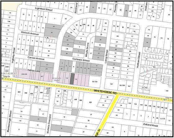
|
|
|
Subject site
|
|
41 Objector Properties
(3 outside of map)
|
é
North
|
BACKGROUND
History
Planning Permit WH/2015/284 was
issued on 12 August 2015 for buildings and works associated with the use of
land for a restaurant (café) and reduction in the standard car parking
requirements. Plans complying with the permit were endorsed on 7
September 2015.
This application to amend the
permit was lodged on 3 June 2016, specifically to extend the hours of the use
from 7am to 4pm seven days a week to 7am to 10pm Monday to Thursday and Sunday,
and 7am to 11pm Friday and Saturday, and to permit the sale and consumption of
liquor. This application was amended after notice to delete the request
to extend the hours of use.
A number of complaints regarding
the operation of the approved restaurant have been received by Council
Officers. These matters do not directly relate to this amendment
application but are relevant to the approved use of the land.
These matters have been resolved
but ongoing inspections will continue to ensure compliance.
The Site and Surrounds
The subject site is located on the
northern side of Whitehorse Road in Mont Albert, 200 metres east of the
intersection with Inglisby Road. The site has a total frontage of 13 metres to
Whitehorse Road and a depth of 40.84 metres and an overall site area of
approximately 544m2. A laneway is located to the rear of the subject
site and is accessible via Victoria Crescent and Laing Street. The subject site
forms part of a larger Mixed Use Precinct which consists of generally single to
double storey buildings with a range of uses including motorcycle sales, car
accessory sales and commercial offices.
On-street metered car parking is
provided directly in front of the subject site and extends along the northern
side of Whitehorse Road. The subject site currently contains an existing
restaurant, which is setback 3m from the frontage with tables and chairs in
this front setback. The site was previously used as an automotive
servicing centre. The building occupies approximately 284m2 of the
site, with the rear yard used for car parking and storage.
The land is well serviced by public
transport with tram stop (Route 109) located approximately 200 metres west of
the subject site and runs into the retail core of Box Hill (approximately 1km
east from the subject site), and Mont Albert train station is 400 metres to the
south.
The land to the north and the south
is primarily residential comprising of single and double storey dwellings.
Planning Controls
Clause 32.04 Mixed Use Zone
The purpose of this Zone is to
provide for a range of residential, commercial, industrial and other uses which
complement the mixed-use function of the locality, to provide for housing at
high densities, to encourage development that responds to the existing or
preferred neighbourhood character and to facilitate the use, development and
redevelopment of land in accordance with the objectives specified in a schedule
to the zone.
A permit is required to use land for
the purposes of a restaurant.
Clause 43.02 Design and
Development Overlay (Schedule 4)
The purpose of this Overlay is to
incorporate specific built form controls for an area where they are
designed. Schedule 4 to the Overlay relates to all neighbourhood activity
centres across Whitehorse. Each activity centre has prescribed building
setbacks and heights based on its locational attributes. The subject site
is located within area 2A – small-medium neighbourhood centre on a wide
main road. The preferred maximum height limit in this area is 14.5
metres.
The current amendment proposes no
buildings or works and as such this Overlay is not relevant to this assessment.
Clause 52.27 Licensed Premises
The purpose of this Particular
Provision is to ensure that licensed premises are situated in appropriate
locations, and that the impact of the licenced premises on the amenity of the
surrounding area is considered.
The application proposes an
on-premises liquor licence and as such needs a permit pursuant to this
particular provision.
PROPOSAL
The application proposes to amend
the existing permit to allow for the sale and consumption of liquor in
association with the restaurant use. The application to amend the hours
of use was withdrawn after notice.
CONSULTATION
Public Notice
The application was advertised by
mail to the adjacent and nearby property owners and occupiers and by erecting a
notice at the Whitehorse Road frontage. Following the advertising period
42 objections have been received from 41 objector properties.
The issues raised are summarised as
follows:
Car parking and traffic
· Insufficient car parking provision will be exacerbated by extended
hours of use.
· Loss of pedestrian safety from increase in traffic.
· Damage to cars parking in the surrounding streets.
· Approval of nearby apartment building will exacerbate lack of
on-street car parking spaces.
· Parking restrictions not adequately enforced by Council.
· Safety concerns with extensive parking in surrounding road network,
including illegal parking.
Amenity impacts
· Potential increase in anti-social and criminal behaviour due to
alcohol consumption.
· Amenity and noise impacts and parking issues from extended hours and
liquor license.
· Liquor licence not consistent with the dry history of the area.
· No alcohol management plan provided with the application.
· Consumption of alcohol outside the building.
Concerns
with existing permit
· Insufficient car parking provision for the existing use.
· Patrons currently park in residential streets and unreasonably
occupy car parking spaces and increase traffic movements.
· Visitors to the site park illegally and don’t follow road
rules in the surrounding road network.
· Cooking smells emitted from the site.
· Noise impacts from waste collection.
· Waste collection currently carried out at inappropriate hours.
· Waste not appropriately contained within the site.
· Non-compliance with the existing permit in regards to car parking
provision, hours of use, patron numbers and storage/collection of rubbish.
· Majority of patrons are not locals.
· Noise impacts at night from existing illegal operation.
· Noise impacts from existing use.
· Intensity of current use exceeds that of a café.
Other
matters
· Inadequate advertising for the application to amend the permit.
· Inability of Council street sweepers to access the surrounding road
network.
· Property devaluation.
Consultation Forum
A Consultation Forum was held on 8
December 2016 at Box Hill Town Hall, chaired by an external facilitator.
Approximately 30 objectors attended the meeting, as well as planning officers
and both Ward Councillors.
A large number of concerns were
discussed at the forum, including the impact the existing restaurant is having
on car parking availability in the area, existing amenity impacts, the likely
impacts from the extended hours and the amenity impacts from the sale of
liquor.
While no resolutions were reached
at the forum, it is noted that the applicant amended the application after the
meeting in response to these discusses to remove the request to extend the hours
of use.
Section 57A amendment
The application to amend the permit
was amended after notice under section 57A of the Planning and Environment
Act 1987 to remove the request to extend the hours of use. This
amendment was received on 16 December 2016 and was made in response to the
issues and concerns raised by objectors at the consultation forum.
This amendment was not
re-advertised as the deletion of the changes to the hours of use will not
result in any further material detriment to the surrounding land users.
Referrals
No referrals, either internal or
external, were required.
DISCUSSION
Consistency with State and Local
Planning Policies
The continued use
of the land as a restaurant is supported by the State and Local Planning
Policies. The inclusion of the sale and consumption of liquor in
association with the existing restaurant use is also supported by these
policies.
Clause 52.27 Licensed Premises
It is considered the on-premises
liquor licence will have no adverse impacts on the amenity of the area and is
an appropriate outcome.
The hours for the sale of liquor
will be aligned with the restaurant, which as noted above are from 7am-4pm
Monday to Sunday. Some limitation will be placed on the ability to sell
liquor beyond the hours of use, as required by the liquor licencing
authority. As the proposed sale and consumption will cease at 4pm, this
will discourage inappropriate consumption of liquor after business hours and in
to the evening.
The liquor licence will also be
linked to the restaurant and liquor sales will only be able to occur in
conjunction with the service of food. This will discourage the
inappropriate consumption of liquor.
There are few, if any, premises
nearby that sell liquor. This part of Whitehorse is in a Dry Area where
the sale and consumption of liquor is highly regulated and limited to approved
restaurant uses. On this basis it is considered the cumulative impact of
existing licensed premises and the proposal will be low.
Objectors Concerns
· Insufficient car parking provision will be exacerbated by extended
hours of use.
· Approval of nearby apartment building will exacerbate lack of
on-street car parking spaces.
The existing permit currently allows up to 108 people to be
permitted on the site based on the provision of six car parking spaces in the
rear setback of the site. The patron numbers are not sought to be changed
and it is not considered the approval of a liquor licence will affect this
requirement.
· Loss of pedestrian safety from increase in traffic.
The
amendment to the permit will have no effect on the amount of traffic in the
surrounding road network.
· Damage to cars parking in the surrounding streets.
This is
not considered to be a relevant planning consideration.
· Parking restrictions not adequately enforced by Council.
· Safety concerns with extensive parking in surrounding road network,
including illegal parking.
Officers
from Council’s Community Laws Department have undertaken regular
inspections of the surrounding road network to ensure compliance with the
parking restrictions, and will continue to do so.
· Potential increase in anti-social and criminal behaviour due to
alcohol consumption.
It is
considered that the hours of sale and consumption of liquor and the requirement
that liquor only be consumed in conjunction with meals will discourage
inappropriate behaviours.
· Amenity and noise impacts and parking issues from extended hours and
liquor licence.
No
extended hours are now proposed. It is not considered that the approval
of a liquor licence will have any impact on noise, amenity or parking issues in
the area.
· Liquor licence not consistent with the dry history of the area.
While the
surrounding area is subject to a dry area restriction, this was amended by poll
to allow liquor licenses associated with restaurants. There are large
numbers of restaurants in the Box Hill area with liquor licences and the
current proposal is considered to be consistent with these existing uses.
· No alcohol management plan provided with the application.
No alcohol
management plan is required by the Whitehorse Planning Scheme and is a matter
for the granting of the liquor licence by the Victorian Commission for Gambling
and Liquor Regulation.
· Consumption of alcohol outside the building.
All liquor
must be consumed in accordance with the planning permit and liquor licence,
which will include the area in front of the building facing Whitehorse Road.
· Insufficient car parking provision for the existing use.
As noted
above, the amendment to the permit does not seek to amend the hours of use, the
number of patrons or to reduce the car parking provision any further and as
such this matter cannot be considered through this assessment.
· Patrons currently park in residential streets and unreasonably
occupy car parking spaces and increase traffic movements.
· Visitors to the site park illegally and don’t follow road
rules in the surrounding road network.
As noted
above, officers from Council’s Community Laws Department have undertaken
regulator inspections of the area to achieve compliance with the parking
regulations.
· Cooking smells emitted from the site.
The
applicant is aware of their obligations to ensure that the site complies with
the building and health regulations.
· Noise impacts from waste collection.
· Waste collection currently carried out at inappropriate hours.
The
applicant has given a commitment to ensure that waste is collected from the
site during reasonable hours. Council’s Planning Enforcement
officer has been undertaking investigations of the site to ensure that waste
collection does not unreasonably impact the amenity of the surrounding
area. However, some noise from the collection of waste is unavoidable
given the close proximity of dwellings to the rear of the commercial properties
fronting Whitehorse Road.
· Waste not appropriately contained within the site.
Council’s
Planning Enforcement Officer has undertaken investigations of the site to
ensure waste is being stored appropriately.
· Non-compliance with the existing permit in regards to car parking
provision, hours of use, patron numbers and storage/collection of rubbish.
Council’s
Planning Enforcement Officer has undertaken investigations of the site to
ensure the use is being carried out in accordance with the planning permit.
· Majority of patrons are not locals.
This is
not considered to be a relevant planning consideration.
· Noise impacts at night from existing illegal operation.
While
non-compliance with the conditions of the restaurant permit has occurred in the
past, the applicant has made undertakings that all future use of the land will
be in accordance with the hours specified in the permit. This will be
monitored by Council’s Planning Enforcement Officer.
· Noise impacts from existing use.
Council’s
Planning Enforcement Officer has been undertaking investigations of the site to
ensure the use is not causing unreasonable amenity impacts on the surrounding
land.
· Intensity of current use exceeds that of a café.
The
intensity of the use is consistent with the permit that was granted for a 108
seat restaurant.
· Inadequate advertising for the application to amend the permit.
The
application was advertised in accordance with the requirements of the Planning
and Environment Act 1987.
· Inability of Council street sweepers to access the surrounding road
network.
This is
not a relevant matter for this assessment.
· Property devaluation.
This is
not a relevant matter for this assessment.
CONCLUSION
The amendment to Planning Permit
WH/2015/284 (Issued for buildings and works associated with the use of land for
a restaurant (cafe) and reduction of the standard car parking requirements) to
include use of land for the sale and consumption of liquor is an acceptable
response that satisfies the relevant provisions contained within the Whitehorse
Planning Scheme, including the State and Local Planning Policies, the Mixed Use
Zone and Clause 52.27 Licensed Premises.
The sale and consumption of liquor
in association with an existing restaurant is unlikely to result in
unreasonable amenity impacts on the surrounding area, while enhancing the
restaurant use. The applicant has responded to concerns from objectors
about extending the hours of use by further amending the application to delete
this request.
A total of 42 objections were
received as a result of public notice and all of the issues raised have been
discussed as required.
It is recommended that the
application be approved subject to additional conditions relating to liquor
licencing and an updated permit pre-amble
Attachment
1 Original Permit
⇨ 
2 Red Line Plan ⇨ 
9.1.2 12-18
Barkly Terrace, MITCHAM (LOT 1-4 PS 628516M)– Use and development of land
as a childcare centre and display of a business identification sign
FILE NUMBER: WH/2016/985
ATTACHMENT
SUMMARY
This application was advertised,
and a total of 14 objections were received. The objections raised issues with
traffic and parking, residential amenity and landscaping. A Consultation Forum
was held on 1 February 2017 chaired by Councillor Cutts, at which
the issues were explored and some resolutions were reached between the parties.
This report assesses the application against the relevant provisions of the
Whitehorse Planning Scheme, as well as the objector concerns. It is
recommended that the application be supported, subject to conditions.
|
Council
Resolution
Moved by Cr Cutts,
Seconded by Cr Stennett
That Council:
A. Being the Responsible Authority, having
caused Application WH/2016/985 for 12-18 Barkly Terrace, MITCHAM (LOT 1-4 PS
628516M) to be advertised and having received and noted the objections is of
the opinion that the granting of a Planning Permit for the Use and
development of land as a childcare centre and display of a business
identification sign is acceptable and should not unreasonably impact the
amenity of adjacent properties.
B. Issue a Notice of Decision to Grant a Permit
under the Whitehorse Planning Scheme to the land described as 12-18
Barkly Terrace, MITCHAM (LOT 1-4 PS 628516M) for the Use and development as a
childcare centre and display of a business identification sign, subject to
the following conditions:
1. Before
the development starts, or any trees or vegetation removed, amended plans
(three copies in A1 size and one copy reduced to A3 size) shall be submitted
to and approved by the Responsible Authority. The plans must be drawn to
1:100 scale, with dimensions, and be generally in accordance with the plans
submitted with the application but modified to show:
a) Relocation
of the turning bay to where car space 8 is located. The turning bay is to be
reduced by 2 metres in length and the area is to be developed as garden area.
b) The
acoustic fence along the eastern boundary must have a minimum height of 2.0
metres.
c) Provision
of appropriate low level lighting to the car park area.
d) Parking
Management Plan in accordance with Condition 7.
e) A
Waste Management Plan in accordance Condition 11.
f) Landscape
Plan in accordance with Condition 3, including the following:
i. Removal
of Trees 1 and 2. These trees must be replaced with two canopy trees capable
of growing in excess of 8 metres in height at maturity in the outdoor play
area.
ii. The
provision of a minimum of three canopy trees capable of growing in access of
4 metres in height around the car park area.
iii. The
planting within and around the perimeter of the site is to comprise trees and
shrubs with all trees to be located within mulched garden beds.
iv. All
new trees must be planted at a minimum height of 1.5 metres.
All of the above must be to
the satisfaction of the Responsible Authority. Once approved these plans
become the endorsed plans of this permit.
2. The
layout of the site and the size, design and location of the buildings and
works permitted must always accord with the endorsed plan and must not be
altered or modified without the further written consent of the Responsible
Authority.
3. No
buildings or works must be commenced (and no trees or vegetation shall be
removed) until a landscape plan prepared by a suitably qualified and
experienced person or firm has been submitted to and endorsed by the
Responsible Authority. This plan when endorsed shall form part of this
permit. This plan shall show:
a) A
survey of all existing vegetation, abutting street trees, natural features
and vegetation.
b) Buildings,
outbuildings and trees in neighbouring lots that would affect the landscape
design.
c) No
trees are to be planted within the easement.
d) Planting
within and around the perimeter of the site comprising trees and shrubs
capable of:
i. Providing
a complete garden scheme,
ii. Softening
the building bulk,
iii. Providing
some upper canopy for landscape perspective,
e) A
schedule of the botanical name of all trees and shrubs proposed to be
retained and those to be removed incorporating any relevant requirements of
condition No. 1.
f) The
proposed design features such as paths, paving, lawn and mulch.
g) A
planting schedule of all proposed vegetation (trees, shrubs and ground
covers) which includes, botanical names, common names, pot size, mature size
and total quantities of each plant.
Landscaping in
accordance with this approved plan and schedule shall be completed before the
addition to the building is occupied.
Once approved these
plans become the endorsed plans of this permit.
4. The
garden/play areas shown on the endorsed plan must only be used as
gardens/play areas and must be maintained in a proper, tidy and healthy
condition to the satisfaction of the Responsible Authority. Should any
tree or shrub be removed or destroyed it may be required to be replaced by a
tree or shrub of similar size and variety.
5. Unless
with the prior written consent of the Responsible Authority, not more than 54
children are permitted on the premises at any one time.
6. Unless
with the prior written consent of the Responsible Authority, the use is only
permitted between 6.30am and 7.00pm, Mondays to Fridays.
Car Parking Management
7. Prior
to the commencement of buildings and works on the site, the owner must
prepare a Car Parking Management Plan detailing the management of the use of
car parking on site to the satisfaction of the Responsible Authority. The Car
Parking Management Plan must provide for but not be limited to:
a) Management of the use of the car park for
staff during the course of the day;
b) Details of how the management plan will be
distributed to staff and parents to ensure all are aware of the document and
parking arrangements;
c) Provision of designated car parking spaces
for use by parents;
d) Method of identifying car parking spaces for
patrons;
e) Details of
security to be provided within the car park particularly outside of normal
business hours.
f) Details of the management of the use
of the car park for staff and users during special events.
Once submitted to and
approved by the Responsible Authority the Car Parking Management Plan will
form part of the documents endorsed as part of this planning permit.
8. No
equipment, services, architectural features or structures of any kind,
including telecommunication facilities, other than those shown on the endorsed
plans shall be permitted above the roof level of the building unless
otherwise agreed to in writing by the Responsible Authority.
9. The
car parking areas and access ways as shown on the endorsed plans shall be
formed to such levels so that they may be used in accordance with the plan,
and shall be properly constructed, surfaced, drained and line-marked (where
applicable). The car park and driveways shall be maintained to the
satisfaction of the Responsible Authority.
10. Before
occupation of the development hereby permitted, areas set aside for parking
vehicles, access lanes and paths as shown on the endorsed plans must be:
a) Constructed to the satisfaction
of the Responsible Authority.
b) Properly formed to such levels
that they can be used in accordance with the plans.
c) Surfaced with an all-weather
sealcoat to the satisfaction of the Responsible Authority.
d) Drained to the satisfaction of
the Responsible Authority.
e) Line-marked to indicate each car
space, all access lanes and, if necessary, the direction in which vehicles
are to travel to the satisfaction of the Responsible Authority.
f) In accordance with any
Council adopted guidelines for the construction of car parks.
g) Parking areas and access lanes
must be kept available for these purposes at all times and maintained to the
satisfaction of the Responsible Authority.
Waste Management
11. Prior
to the commencement of works on the site, the owner shall prepare an amended
Waste Management Plan for the collection and disposal of garbage and
recyclables for all uses on the site to the satisfaction of the Responsible
Authority. The Waste Management Plan must provide for:
a) The method of collection of garbage and
recyclables for the use;
b) Designation of methods of collection
including the need to provide for private services;
c) Appropriate areas of bin storage on site to
be accommodated within the basement;
d) Measures to minimise the impact upon local
amenity and on the operation, management and maintenance of car parking
areas;
e) Litter management.
Once submitted to and
approved by the Responsible Authority the Waste Management Plan will form
part of the documents endorsed as part of this planning permit.
12. Adequate
provision, to the satisfaction of the Responsible Authority, must be made for
the storage and collection of garbage, bottles and other solid wastes in bins
or receptacles. All bins and receptacles used for the storage and collection
of garbage, bottles and other solid wastes must, to the satisfaction of the
Responsible, be kept in a storage area screened from view. All bins and
receptacles must be maintained, to the satisfaction of the Responsible
Authority, in a clean and tidy condition and free from offensive odour.
Construction
Management
13. Prior
to the commencement of buildings or works on the land, a Construction
Management Plan, detailing how the owner will manage the environmental and
construction issues associated with the development, must be submitted to and
approved by Council.
This plan is to be to
the satisfaction of the Responsible Authority and must be prepared in
accordance with the City of Whitehorse Construction Management Plan
Guidelines.
Once submitted to and
approved by the Responsible Authority the Construction Management Plan will
form part of the documents endorsed as part of this planning permit.
When approved the
Construction Management Plan will form part of this permit and must be
complied with, to the satisfaction of the Responsible Authority, to the
extent that this is in the control of the owner of the land. The owner of the
land is to be responsible for all costs associated with the works to be
undertaken in accordance with the requirements of the Construction Management
Plan.
Amenity
14. The
amenity of the area shall not be detrimentally affected by the use or
development, through:
a) Transportation
of materials, goods or commodities to or from the land;
b) Appearance
of any building, works or materials;
c) Emission
of noise, artificial light, vibration, smell, fumes, smoke, vapour, steam, soot ash, dust, waste water, waste
products, grit or oil;
d) Presence
of vermin; and
e) In
any other way.
15. Alarms
must be directly connected to a security service and must not produce noise
beyond the premises.
16. No
external sound amplification equipment or loudspeakers are to be used for the
purpose of announcements, broadcasts or playing of music.
17. All
external lights must be of a limited intensity to ensure no nuisance is
caused to adjoining or nearby residents and must be provided with approved
baffles, so that no direct light or glare is emitted outside the site.
Advertising Sign
18. The
advertising sign and panels shall be constructed and maintained to the
satisfaction of Responsible Authority. Any sign in a state of disrepair
shall, at the direction of the Responsible Authority, be removed from the
site.
19. Except
where no permit is required under the provisions of Clause 52.05 of the
Planning Scheme, no additional advertisement or sign other than that already
permitted shall be erected or established on the site without the prior
written consent of the Responsible Authority. In this context it is
noted an advertisement includes painted on advertising media, flags, bunting,
streamers or similar devices used for advertising, and the control extends to
an advertisement inside a building which can ordinarily be seen by a person
who is outside the building.
20. The
sign permitted must not be illuminated or floodlit.
21. The
sign shall not alter its message or move in part or whole.
22. No
bunting, streamers and festooning shall be displayed.
23. The
sign/s shall only contain an advertisement which provides or supplies
information relating to the business conducted on the abovementioned land.
Assets Management
24. All
stormwater drains must be connected to a point of discharge to the
satisfaction of Responsible Authority.
25. Prior
to any works, design plans and specifications of the civil works within the
site associated with the development are to be prepared by a registered
consulting engineer, and submitted to the Responsible Authority.
Certification by the consulting engineer that the civil works have been
completed in accordance with the design plans and specifications must be
provided to the Responsible Authority.
26. Detailed
civil plans and computations for stormwater on-site detention (if required)
and connection to the legal point of discharge must be prepared by a suitably
experienced and qualified professional, and submitted for approval by
Responsible Authority prior to the commencement of any works.
27. Stormwater
connection to the nominated point of discharge and stormwater on-site
detention (if required) must be completed and approved to the satisfaction of
the Responsible Authority prior to the occupation of the building.
28. Stormwater
that could adversely affect any adjacent land shall not be discharged from
the subject site onto the surface of the adjacent land.
29. The
Applicant/Owner shall be responsible to meet all costs associated with
reinstatement and/or alterations to Council or other Public Authority assets
deemed necessary by such Authorities as a result of the development.
The Applicant/Owner shall be responsible to obtain an "Asset Protection
Permit" from Council at least 7 days prior to the commencement of any
works on the land and obtain prior specific written approval for any works
involving the alteration of Council or other Public Authority assets.
30. The
proposed vehicle crossing must adhere to Whitehorse Council’s –
Vehicle Crossing General Specifications.
31. Any
services that need to be removed and relocated due to the location of the proposed
vehicular crossing must be financed by the developer.
32. Any
services that need to be removed and relocated due to the location of the
proposed vehicular crossing must be approved by the Responsible Authority
prior to endorsement of the plans.
33. Any
trees that need to be removed due to the location of the proposed vehicle
crossing must be approved by Parkswide prior to endorsement of the plans.
VicTrack Conditions
34. The
permit holder must, at all times, ensure that the common boundary with the railway
land is fenced at the permit holder’s expense to prohibit unauthorised
access to the car park.
35. The
permit holder must not, at any time:
a) Allow any drainage, effluent,
waste, soil or other materials to enter or be directed to the railway land;
or
b) Store or
deposit any waste, soil or other materials on the railway land.
36. Any
wall/fence to be built on the common boundary between the subject land and
the VicTrack land must be cleaned and finished using a graffiti proof finish
at the cost of the permit holder. VicTrack, in consultation with the Rail
Operator, may nominate alternative measures to be implemented, at the cost of
the permit holder, to prevent or reduce the potential for graffiti. Any
graffiti that appears on the wall must be cleaned or removed as soon as
practicable to the satisfaction of the Responsible Authority. The cost of any
clean-up or removal of the graffiti from the wall must be borne by the permit
holder and/or the future owners of the land.
37. The
permit holder must not carry out, or allow to be carried out, any excavation,
filling or construction on the common boundary between the subject land and
the railway land unless it has obtained the prior written approval of
VicTrack and the Rail Operator.
38. All
works, including hoardings, must be undertaken within the subject land and
must not encroach onto the railway land.
Permit Expiry
39. This
permit will expire if one of the following circumstances applies:
a) The
development is not commenced within two (2) years from the date of issue of
this permit.
b) The
development is not completed within four (4) years from the date of this
permit.
c) The use
is not commenced within one (1) year from the completion of the development.
The Responsible
Authority may extend the periods referred to if a request is made in writing
pursuant to the provisions of Section 69 of the Planning and Environment Act
1987.
Permit Notes
A. Soil
erosion control measures must be adopted at all times to the satisfaction of
the Relevant Authority during the construction stages of the
development. Site controls and erosion minimisation techniques are to
be in accordance with the EPA (Environment Protection Authority) Victoria
“Environmental Guidelines for Major Construction Sites”. The
works during and after construction must comply with the above guidelines and
in potentially high erosion areas a detailed plan may be required to indicate
proposed measures and methodology.
B. The
property owner/ builder is to obtain the relevant permits and consents from
Council in relation to asset protection, drainage works in easements and
works in the road reserve prior to the commencement of any works.
C. All
stormwater drainage within the development site and associated with the
building(s) (except for an on-site detention system and connection to the
nominated legal point of discharge within the site) must be approved and
completed to the satisfaction of the Building Surveyor prior to the
occupation of the building(s), in accordance with the provisions of the
Building Regulations (2006) section 610.
D. All
of the structures/ any works (excavation/fill)/ planting over the drainage
easement should be referred to the engineering asset team of council and
resolved prior to endorsement of the plans.
E. Minimum
floor levels for any habitable areas must be determined by the engineering
asset team of council prior to the endorsement of the plans. The applicant
has to be informed in the early stage to apply for a consent and report
– minimum floor levels.
F. The
surface treatment and design of all crossovers and driveways shall be of
materials submitted to and approved by the Responsible Authority and must be
constructed in accordance with the submitted details.
G. No
alteration to existing interface levels will be permitted other than to
maintain or introduce adequate and consistent road reserve crossfall and
longitudinal fall all to the satisfaction of the Responsible Authority.
H. Access
to the development must be resolved within the development site. No
provision for access and/or Disability Discrimination Act (DDA) compliance
will be permitted external to the site being within any adjacent road
reserve, right of way, reservation or other land owned managed by the Responsible
Authority as may be applicable.
I. The
proposed vehicle crossing must adhere to Whitehorse Council’s –
Vehicle Crossing General Specifications.
J. Any
services that need to be removed and relocated due to the location of the
proposed vehicular crossing must be financed by the developer.
K. Any
services that need to be removed and relocated due to the location of the
proposed vehicular crossing must be approved by the Responsible Authority
prior to endorsement of the plans.
C. Has made this decision having particular
regard to the requirements of Sections 58, 59, 60 and 61 of the Planning and
Environment Act 1987.
Carried
Unanimously
|
MELWAYS REFERENCE 48 K9
|
Applicant: The
Ellis Group Architects
Zoning: General
Residential Zone, Schedule 2
Overlays: Nil
Relevant Clauses: Clause
11 Settlement
Clause
12 Environment and Landscape
Values
Clause
15 Built Environment and
Heritage
Clause
19 Infrastructure
Clause 21.05
Environment
Clause 21.06
Housing
Clause 21.08
Infrastructure
Clause 22.02
Visual Amenity and Advertising Signs
Clause 22.03
Residential Development
Clause 22.04
Tree Conservation
Clause 22.05
Non-residential uses in residential areas
Clause 52.05
Advertising Signs
Clause 52.06 Car
Parking
Clause
65 Decision Guidelines
Ward: Springfield
|
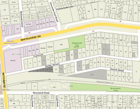
|
|
|
Subject
site
|
|
14
Objector Properties*
(2
outside of map)
|
é
North
|
|
|
|
|
|
* 2-24 Church Street contains two (2) objector properties
|
BACKGROUND
History
Planning Permit
WH/2004/15064 was issued on 13 December 2005 for the development of four
dwellings on a lot.
Planning Permit
WH/2009/205 was issued on 10 August 2009 for the subdivision of land into four
lots.
Planning Permit
WH/2016/646 was issued on 31 August 2016 for the construction of four double
storey dwellings.
The Site and Surrounds
The subject site is located on the
southern side of Barkly Terrace, Mitcham, approximately 100 metres east of the
intersection with Mitcham Road. The site is triangular in shape, has a frontage
of 100 metres to Barkly Terrace, 99 metres along the southern side boundary and
a depth of between 3.4 and 24.7 metres. These dimensions form a total site area
of 1,288 square metres. The subject site is not subject to any easement and has
no covenants registered on title.
The site is currently vacant and
was previously part of the construction workers car park of the Level Crossing
Removal Authority when Mitcham Road level crossing was removed. The site is
accessed from Barkly Terrace via a concrete crossover in between 14 and 16
Barkly Terrace. There are three canopy trees on site, a Pinus radiata, a
Eucalyptus ovata and a Prunus domestica.
The adjoining properties to the
east and the north of the subject site are generally residential in nature,
while to the west and south is the Mitcham Railway Station commuter car park.
Planning Controls
State
Planning Policy Framework
An objective of
Clause 10 (Operation of the State Planning Policy Framework) suggests planning
should address social needs by addressing aspects of economic, environmental
and social well-being affected by land use and development. Responsible
authorities should integrate assessment of policies and issues surrounding
conflicting objectives in favour of net community benefit.
Clause 11
(Settlement) aims to ensure that planning facilitates investment in social
facilities. This is supported by Clause 11.02-1 (Supply of urban land) that
aims to ensure a sufficient supply of land is available for residential,
commercial, retail, industrial, recreational and institutional and other
community uses and Clause 11.04-4 (Liveable communities and neighbourhoods)
that aims to create healthy and active neighbourhoods through planning for
future social infrastructure.
Clause 15
(Built Environment and Heritage) states that planning should ensure all new
land use and development appropriately responds to its landscape, valued built
form and cultural context and should create quality built environments that
support the social, cultural, economic and environmental wellbeing of
communities, cities and towns.
Clause 19 (Infrastructure)
states that planning is to recognise social needs, by enabling appropriate land
for a range of accessible community resources such as education, cultural,
health and community support (mental health, aged care, disability, youth and
family services) facilities. Planning should be guided by social and physical
infrastructure, which can be provided in an efficient, equitable, accessible
and timely way. Clause 19.02-4 (Distribution of Social and Cultural
Infrastructure) supports this objective by requiring fairer distribution of,
and access to, social infrastructure.
Municipal
Strategic Statement
Clause 21.06
(Housing) of the Municipal Strategic Statement considers the compatibility of
residential and non-residential uses and aims to ensure buildings for
non-residential uses are designed to integrate with and respect the surrounding
neighbourhood character and to ensure non-residential uses do not cause
detriment to the community or amenity of the surrounding area. It is policy
that all non-residential use and development applications comply with Clause
22.05 (Non-Residential Uses in Residential Areas).
Clause 21.08
(Infrastructure) of the Municipal Strategic Statement identifies that
non-residential traffic travelling on residential streets should be
appropriately minimised and managed to ensure reduction of through traffic.
Local Policy
Clause 22.02
(Visual amenity and advertising signs) sets out Council’s policy to
ensure that the scale and nature of signage is appropriate to the role and
character of its surrounds. It is policy that in residential areas the quantity
of signs is encouraged to be kept to a practical minimum, with a maximum height
of 2 metres and area of 2 square metres to minimise visual intrusion into the
residential streetscape and reduce detriment to the amenity of abutting
residential properties.
Clause 22.03
(Residential Development) applies to all applications for development within
the Neighbourhood Residential Zone, General Residential Zone, Residential
Growth Zone, Mixed Use and Priority Development Zones. The objectives of this
policy include ensuring development contributes to the preferred neighbourhood
character and provides adequate gardens and vegetation.
Clause 22.04
(Tree Conservation) considers the importance of tree conservation in the City
of Whitehorse and how it represents a significant determinant of neighbourhood
character. This policy includes a number of performance standards in relation
to tree retention and regeneration. One of the key objectives of the policy is
to identify techniques to assist in the successful co-existence of trees and
new buildings or works.
Clause 22.05
(Non-Residential Uses in Residential Areas) sets out Council’s
policy with respect to non-residential uses serving the needs of the local
community in residential areas. This policy has the objective to avoid the
concentration of non-residential uses where the amenity of the residential area
will be detrimentally affected.
It also
includes a number of performance standards in relation to location, building
design, car parking, landscaping and amenity, which are considered to satisfy
the policy objectives, listed above.
Zone
The site is
located within a General Residential Zone. The use of the site for a Child Care
Centre is not listed in the Table of Uses. Any use not listed in Sections 1 and
3 of the Table of Uses is assessed as a Section 2 Use and requires a planning
permit to operate.
Pursuant to
Clause 32.08-7, a permit is required to construct a building or construct or
carry out works for a use in Section 2 of Clause 32.09-1.
Car Parking
Provisions
Clause 52.06-1
of the Planning Scheme details specific car parking requirements for a new use.
Pursuant to Clause 52.06-2, prior to a new use commencing, the number of car
parking spaces under Clause 52.06-3 must be provided on the land or as approved
under Clause 52.06-3 to the satisfaction of the Responsible Authority.
Clause 52.06-5
requires 0.22 spaces per child for the use of a child care centre. If in
calculating the number of car parking spaces the result is not a whole number,
the required number of car parking spaces is rounded down to the nearest whole
number.
A permit
application under this Clause was not required as the applicant has provided 11
car parking spaces, meeting the required 11.88 spaces required under the
Scheme.
Advertising
Sign Provisions
In accordance with Clause 32.08-12
of the General Residential Zone the advertising sign requirements are located
in Category 3 of Clause 52.05 (Advertising Signs).
In accordance with Clause 52.05-9
(Category 3 – High Amenity Areas) a planning permit is required to display
a Business Identification Sign.
PROPOSAL
The application proposes the use
and development of the land for a Child Care Centre, and display of a Business
Identification Sign. The existing house and outbuildings would be demolished
and a purpose built facility constructed. The proposal involves the following:
· Facility
to accommodate 54 child care places.
· The
new building is single storey with car parking located to the east of the
proposed building.
· Provision
of eleven car parking spaces to the side of the building including one disabled
car parking space.
· The
building has a front setback of 3 metres from Barkly Terrace, 18.2 metres from
the eastern boundary and a 39.2 metre long wall is to be constructed on the
southern boundary abutting the railway station car park.
· Provision
of three child care rooms, kitchen, laundry and office, reception area and
amenities.
· Operating
hours are proposed between 6:30am to 7:00pm Monday to Friday.
· Access
via a proposed crossover with a width of 6 metres located towards the northeast
corner of the site. The existing crossover is to be reinstated.
· The
business identification sign will be mounted on the façade of the
building facing the east. The signage will be 4.2m wide and 0.4 metres high and
will identify the centre. No illumination is proposed.
CONSULTATION
Public Notice
The application was advertised by
mail to the adjacent and nearby property owners and occupiers and by erecting
notices to the Barkly Terrace frontage and along the southern side boundary
facing the railway station car park. Following the advertising period 14
objections were received.
The issues raised are summarised as
follows:
Traffic and Parking
· Increased
traffic congestion/hazards on Barkly Terrace
· Barkly
Terrace is a narrow and busy road
· Flow
on effects of increased traffic congestion/hazard on Church Street and Mitcham
Road
· Site
may be accessed via residential end of Barkly Street
· Inadequate
on-site parking and turning space
· Lack
of drop off and pick up area
· No
standing area in front of proposed centre may be used for drop off/pick up
· Parking
restrictions will be ignored/unenforced
· Railway
car park is full early and cannot be used as overflow parking
· Impossible
to substantiate whether parents will use the train
· Pedestrian
and child safety issues
· Footpath
in front of centre should be widened
Residential Amenity
· Commercial
use in residential area
· Operating
hours excessive, particularly the 6.30am start time
· Noise
· Need
an acoustic fence along direct residential boundary
Landscaping
· Landscape
plan should be provided including new trees
· Pine
Tree should be replaced
Notification
· Extent
of notification should have included Church Street residents given Barkly
Terrace is the only access to this street
Consultation Forum
A Consultation Forum was held on 1
February 2017. Five (5) objectors attended the meeting.
In the consultation meeting, the
following agreements have been reached between the permit applicant and the
objectors:
· Increase
the acoustic fence along the eastern boundary from 1.8 to 2 metres in height.
· Removal
of the Pinus radiata and Eucalyptus ovata, as the first one is an environmental
weed and the other is leaning and poses a risk to road users and children in
the proposed child care centre.
Referrals
External
VicTrack (Recommending Referral
Authority)
VicTrack as been notified under
Section 52 of the Planning and Environment Act 1987, as the subject site
directly a abuts railway station car park. VicTrack raised no objection to the
proposal provided that conditions be included if a permit is issued.
Internal
Engineering and Environmental
Services Department
Transport Engineer
The application has been reviewed
by Council’s Transport Engineer who supports the proposal.
Assets Engineer
The application has been reviewed
by Council’s Assets Engineer who supports the proposal.
Planning Arborist
Council’s Planning Arborist
has reviewed the proposal and commented that the Pinus radiata
and Eucalyptus ovata trees are suitable to be removed as the Pinus
is an environmental weed while the Eucalyptus is fair in structure.
DISCUSSION
Consistency with State and Local
Planning Policies
In broad terms, state policy
recognises the importance of planning for social and physical infrastructure
that enables it to be provided in a way that is efficient, equitable and
timely. Policy also provides that planning is to recognise social needs
by providing land for a range of accessible community facilities. A
purpose of the General Residential Zone also recognises that educational,
recreational, religious, community and a limited range of other non-residential
uses that serve local community needs are appropriate, provided they occur in
appropriate locations.
Facilities like childcare centres
are a type of community facility and social infrastructure and it is important
that they establish in urban areas in appropriate locations. The subject site
is well suited to accommodate the proposed use. It is located within an
established urban area, the area of the allotment lends itself to a
non-residential use and it has a non-residential interface to the south and
west. The site is also located 100 metres from Mitcham Road.
The Municipal Strategic Statement
at Clause 21.06 (Housing) requires development to contribute to the preferred
neighbourhood character of the precinct. Non-residential uses are to
integrate with the built form and character of the surrounding residential
environment.
Objective 2 under Clause 22.03-2
states that it is policy to ensure development contributes to the preferred
neighbourhood character where specified. The applicable precinct in Clause
22.03 is the Bush Suburban, Precinct 2. The preferred character statement for
this precinct is described as follows:
The area will
retain its classic bush suburban characteristics of low scale, pitched-roof
dwellings set in spacious garden settings. The defined pattern of regular front
setbacks and side setbacks from at least one side boundary will be maintained,
allowing sufficient space for planting and growth of new vegetation. New
buildings and additions will appear regular from the street and will be set
back at upper levels to allow views between dwellings.
Low or open
style front fences will provide a sense of openness along the streetscape, and
allow views into front gardens. The landscape character of the area will be
enhanced through the planting and growth of new vegetation, including large
shrubs and tall canopy trees.
Areas with
good access to train stations will accommodate more dwellings with slightly
more compact siting than the remaining residential areas, but with space for
large trees and gardens.
The proposed building is well
setback from boundaries, except the southern side boundary, which abuts the
railway station car park. The generous setbacks will cater for future tree
planting opportunities, which ensure that the proposal nestles appropriately
into the neighbourhood and has regard for the adjoining residential uses to the
east and north.
The
building is well designed in respect of the residential nature of the area,
e.g. pitch roof form, timber features, weatherboard cladding and face brick
finishes. These ensure that the visual compatibility of the purpose built
facility integrates well with the surrounding properties.
It is also
useful to consider the development in terms of Clause 32.08-6 and the specific
requirements of the Schedule to the General Residential Zone. Site coverage of
the development at 33.9% is significantly less than that allowable for a
residential development (50%) and the permeable area at 40.96% is higher than
the minimum of 30% required. The only wall proposed to be constructed on the
boundary will be on the southern boundary, which is well designed to ensure
that it presents as a visually interesting element when viewed from the railway
station car park. The wall constructed on the southern boundary will also act
as a noise barrier to maximise the internal amenity of the proposed child care
centre.
The front
fence provided exceeds 1 metre however the proposed 1.8 metre high childproof
powder coated flat bar fence is considered appropriate within the surrounding
context, as the fence will be highly transparent and there is also evidence of
higher front fences along Barkly Terrace towards the intersection with Church
Street.
Clause 22.05 (Non-Residential
Uses in Residential Areas)
The provisions of the General
Residential Zone provide little specific guidance on how to assess an
application for a non-residential use, and as such the policy at Clause 22.05
is an important decision making tool as it outlines the key considerations in
an assessment of such a use. An objective of the Non-Residential Uses in
Residential Areas Policy is to make provision for services and facilities
demanded by local communities in a way that does not detract from the amenity
of the area. This purpose built child care centre will provide a new and
accessible facility, which will serve the needs of the local community. Permit
conditions relating to an improved parking layout, waste containment within the
basement, landscaping, construction management and parking management of the
site will respond to concerns about unreasonable impacts on the amenity of the
surrounding area.
The policy also aims to avoid the
concentration of non-residential uses where it would have off-site effects that
could be detrimental to residential amenity. This application proposes to use a
site which is sufficiently large to provide for a modern purpose built
child-care centre which will contain its activities within the site boundaries.
Furthermore, the site abuts a non-residential use to the west and south, the
Mitcham Railway Station car park, and is located close to the Mitcham Activity
Centre and train station. The subject site is located within a unique location
and can be seen as the entrance to the residential area.
It is considered that the
agglomeration of community facilities support the policy basis of providing net
community benefit and are compatible with the role and function of the street
and surrounding area.
It should also be noted that it is
not uncommon for child care facilities to be located in local residential
streets in metropolitan Melbourne within walking distance of the local
community. There are also numerous examples of childcare centres being located
in close proximity to railway lines and rail stations.
The subject site has good
locational attributes to accommodate a child care centre, located close to
other community uses and social infrastructure. The site is conveniently
located 150 metres from the Mitcham Activity Centre. This activity centre is
designated as a large neighbourhood centre at the intersection of two main
roads, and enjoys convenient access to public transport, including bus and
metropolitan train services. It is important to note that it is less common for
child care centres to be located within commercial centres due to the floor
area required and higher land value or rental cost in a commercial area,
therefore residential areas are more suited to a child care centre use. This
site offers an advantage in that whilst being within a residential zone, it has
direct abuttal to an activity centre.
The policy aims to ensure that the
design, scale and appearance of premises used for non-residential uses reflect
the residential character of the area and have a minimal visual impact on the
streetscape. The proposal complies with this aspect of the proposal as the
scale of the proposed building generally reflects existing residential
buildings and it is a single storey building to minimise its visual impact on
the streetscape. The height, scale and massing of the development is an
appropriate design response to the site and its context.
The setback to the proposed
building is 3 metres from the street frontage. This setback is in keeping with
that approved for the four dwelling development on the subject site and deemed
satisfactory as it provides a transitional setback between the railway station
car park to the west and the residential dwelling to the east, which is setback
approximately 4.5 metres from Barkly Terrace. Further, given the unusual shape
of the site, and that it narrows significantly towards the west end, a reduced
setback is not unreasonable.
Car Parking and Traffic
The location of the use is
appropriate to the role and function of the road networks and adequate
provision is made for onsite staff and visitor car parking. Barkly Terrace has direct
arterial road connections to both Mitcham Road and Whitehorse Road (via Lee
Parade). Due to the narrower width of Barkly Terrace, the current traffic
volumes are considered moderately low for a road located at the edge of the
activity centre. Therefore, it is not envisaged that there would be an adverse
impact to traffic in the area. This position is supported by Council’s
Transport Engineers.
The number of car parks provided
satisfies Clause 52.06-5 of the planning scheme. An adequate number of staff
car parks are provided which will reduce the demand to park on the street. Car
spaces for dropping off and collecting children are provided on site. Whilst
this parking area is provided, and the objective is met, it will be a condition
of this recommendation that a Parking Management Plan be submitted.
The policy requires non-residential
uses to be discouraged if they will cause nuisance to nearby residential
properties by way of noise, traffic, lighting or loss of security. This is
covered in the Amenity section of this report.
The
proposed car parking layout is considered satisfactory, with an additional
turning space provided within the car park. All car parking spaces comply with
the Australian Standard. It will however be a permit condition to require the
turning bay to be relocated northwards to car space 8, as this will be a
position that vehicles will more likely turn around in if the car park is fully
occupied, while the proposed turning bay located towards the southeast corner
of the subject site will be converted to a car parking space. As the turning
bay does not required to be the full length of a car space, it will also be a
permit condition requiring the eastern most 2 metres of this car space to be a
garden area. These modifications are considered minor in nature and will not
result in a transformation of the application.
A major
concern of the objectors relates to increases in traffic in Barkly Terrace and
the current levels of parking in the area. In accordance with Clause 52.06-9
Council must consider (where relevant) various issues relating to acceptability
of the proposal. In relation to the role and function of nearby roads and the
ease and safety with which vehicles gain access to the subject site, the
proposal provides a double width crossover that allows access and egress to the
site. The existing issue of access and egress for private properties in Barkly
Terrace cannot be considered in this application. It is acknowledged that
during pick up and drop off times for the child care centre, vehicle movements
will increase, however it is also accepted that the road network can
accommodate this and that traffic will largely utilise Mitcham Road as the
primary access point. This will limit the amount of through traffic pushed into
the more traditional residential areas to the east.
In order
to facilitate security measures outside daylight saving hours, a security light
is required to be provided for the car park area. The management of the car
park, details of car parking spaces for parents and details of security will be
required to be submitted as part of the Parking Management Plan. Furthermore,
Council must consider the design and construction standards proposed for
paving, drainage, line marking, signage, lighting and other relevant matters.
It will be a condition of this recommendation that the areas set aside for car
parking will be appropriately identified and line marked. Paving and drainage
are considerations for engineering and would be included as conditions on any
permit granted.
Council must also consider whether
the layout of car spaces and accessways are consistent with the relevant
Australian Standard for car parking. Council’s Transport Engineers have
advised that subject to conditions in accordance with the plans submitted for
comment, the proposal is compliant with Australian Standards.
Use
Within the State and Local Planning
Policy Framework and within the purpose of the General Residential Zone
provisions, there is support for the provision of community facilities which
serve the needs of the community. It has also been long established in the
numerous decisions of the Victorian Civil and Administrative Tribunal that a
child care centre is an appropriate use in a residential area.
Overall it is considered that the
subject site is suitable for the proposed use because of its size and location,
which has been largely explored and assessed above.
Amenity
It is
recognised that noise may be considered an issue associated with child care
centres, and a 54 place centre may cause an increase in noise levels,
particularly from the outdoor playground areas. It is worth noting that this
area has been designed to be away from its residential interface to the east,
therefore the noise impact generated from the use will not be unreasonable.
Further, it is noted that the site and surrounding residential properties have
an interface with the Belgrave-Lilydale train line, which is likely to create
an existing level of background noise to these properties. It is also
considered that child care centres are appropriate within residential areas,
and therefore the noise generated from such a use is considered reasonable in a
residential environment. The Victorian Civil and Administrative Tribunal have
consistently considered the sound of children playing within a residential area
as an acceptable level of noise.
It is
noted that the proposal includes the provision of a 1.8 metre high acoustic
fence along the eastern boundary at the residential interfaces of the site.
This will generally provide an acoustic buffer to the proposed car park area.
As agreed between parties in the Planning Consultation Forum, it will be a
permit condition requiring the acoustic fence along the eastern boundary to be
increased to 2 metres in height. This measure is considered to appropriately
manage any perceived or actual noise emanating from the facility.
During
the construction phase of the development, noise, dust, construction operating
hours and management of construction vehicles will need to be managed
appropriately. In relation to construction operating hours, there will be an
expectation that such hours adhere to EPA regulations. It will be a
condition of any approval given that a comprehensive Construction Management
Plan be prepared and submitted to Council for endorsement prior to any
demolition or construction works commencing.
Limits on
business operating hours are proposed under a condition of any approval given.
The proposed hours of operation take into account the impacts on amenity of
adjoining and nearby landowners and are typical of child care centres.
Any future changes to business operating hours will require the further written
consent of Council.
Landscaping
The
proposal includes the retention of two trees on site including a Pinus
radiata and Eucalyptus ovata within the proposed outdoor play area.
In the Planning Consultation Forum, residents are of the opinion that both
trees should be removed as the Pinus radiata is an environmental weed
and the majority of the canopy of the Eucalyptus ovata is over the
footpath and Barkly Terrace which is posing a safety concern. Council’s
Planning Arborist agrees that the Eucalyptus ovata is of fair structure
and has no objection to its removal. Therefore, conditions will require these
trees to be removed, with appropriate tree species to be planted throughout the
site to better suit the use of the site as a child care centre.
Advertising Signage
The proposed business
identification sign will be displayed on the building’s eastern
façade, which has an advertising area of 1.68 square metres. This is
respectful of the objective under Clause 22.02 (Visual Amenity and Advertising
Signs) in terms of its location and advertising area, as the sign will unlikely
cause unreasonable amenity impact to the residential uses to the north and
east, as the sign will not be illuminated.
Other
Non-planning considerations raised
by the objectors have included the devaluation of land and economic threat to
existing businesses. The Planning Scheme is silent on Council assessing them as
a planning concern and does not provide direction on these matters and are
therefore not able to be considered as part of this planning assessment.
Furthermore, VCAT has consistently determined that devaluation of land is not a
matter to be considered. The Planning and Environment Act 1987 also
expressly states that objections which have been made to secure or maintain
commercial advantage can be rejected.
The existing traffic accessing the
area including The Esplanade is not relevant to the assessment of this
application. The traffic impact assessment regarding traffic generation has
been reviewed and supported by Council’s Transport Engineering
Department.
CONCLUSION
The application
proposes the use and development of land for a child care centre and display of
business identification signage.
An assessment
of the application against the State Planning Policy Framework and Local
Planning Policy Framework, including Council’s Non-Residential Uses in
Residential Areas policy, concludes that this proposal is compliant with
relevant objectives, provisions and criteria. It is also noted that, pursuant
to the objectives of the General Residential Zone, the application is a good
example of providing, in appropriate locations, non-residential uses to serve
local community needs.
The application was advertised and
14 objections from 14 objector properties have been received. All issues raised
have been considered in this report. Subject to conditions relating to traffic
management, modifications to the car parking layout and landscaping, it is
considered that the proposal will adequately satisfy the intent of
Council’s Non-Residential Uses in Residential Areas Policy and the
requirements of the Whitehorse Planning Scheme.
It is recommended that the
application be approved and a Notice of Decision to Grant a Permit be issued
subject to a number of conditions.
Attachment
1 Site and
Elevation Plans ⇨ 
9.1.3 1-3
Kinkora Road, Blackburn (Lot 1 LP 97058 and Lot 1 TP 190433) for the
construction of four double storey dwellings
FILE NUMBER:
ATTACHMENT
SUMMARY
This application
was advertised, and a total of 15 objections have been received. The objections
raise issues with neighbourhood character, traffic and parking, loss of
vegetation, and impacts on amenity. A Consultation Forum was held on 28
September 2016, chaired by Council Officers on behalf of the Ward Councillors
during the care taker period, at which the issues were explored, however no
resolution was reached between the parties. This report assesses the
application against the relevant provisions of the Whitehorse Planning Scheme,
as well as the objector concerns. It is recommended that the application
be supported, subject to conditions.
|
MOTION
Moved by Cr Munroe,
Seconded by Cr Davenport
That Council:
A. Being
the Responsible Authority, having caused Application WH/2016/149 for 1 and 3
Kinkora Road, BLACKBURN (Lot 1 LP 97058 and Lot 1 TP 190433) to be advertised
and having received and noted the objections is of the opinion that the
granting of a Planning Permit for the development of four
double storey dwellings is acceptable and should be supported.
B. Issue
a Notice of Decision to Grant a Permit under the Whitehorse Planning Scheme
to the land described as 1-3 Kinkora Road,
BLACKBURN (Lot 1 LP 97058 and Lot 1 TP 190433P) for the construction of four double storey dwellings,
subject to the following conditions:
1. Before the development starts, or any
trees or vegetation are removed, amended plans (three copies) shall be
submitted to and approved by the Responsible Authority. The plans must
be drawn to scale, with dimensions, and be generally in accordance with the
submitted received on 4 July 2016, but modified to show:
a) The locations of Tree
Protection Zones described in condition 5, with all nominated trees clearly
identified and numbered on both site and landscape plans, and the
requirements of conditions 5 and 6 to be annotated on the development and
landscape plans.
b) Alterations to the Dwellings 3 and 4, and the
accessway to enable vehicles to access and egress both car spaces in the
garages in a forward facing direction, in accordance with Clause 52.06 of the
Whitehorse Planning Scheme, with no reduction of any building setbacks.
c) Declare all hard surface areas in the service
yards and review the permeability figures accordingly.
d) Notation on site plans indicating that
all obscured glazing be manufactured from obscured glass. Obscure film being
applied to clear glazing will not be accepted.
e) A detailed schedule of all external
cladding colours, textures, finishes, and materials.
f) A Landscaping Plan in accordance
with Condition 3.
All of
the above must be to the satisfaction of the Responsible Authority. Once
approved these plans become the endorsed plans of the permit.
2. The layout of the site and the size,
design and location of the buildings and works permitted must always accord
with the endorsed plan and must not be altered or modified without the
further written consent of the Responsible Authority.
3. No building or works shall be
commenced (and no trees or vegetation shall be removed) until a landscape
plan prepared by a suitably qualified and experienced person or firm has been
submitted to and endorsed by the Responsible Authority. This plan when
endorsed shall form part of this permit. This plan shall show:
a) A
survey of all existing vegetation, abutting street trees, natural features
and vegetation.
b) Buildings,
outbuildings and trees in neighbouring lots that would affect the landscape
design.
c) Planting
within and around the perimeter of the site comprising trees and shrubs
capable of:
i. Providing
a complete garden scheme,
ii. Softening
the building bulk,
iii. Providing
some upper canopy for landscape perspective,
iv. Minimising
the potential of any overlooking between habitable rooms of adjacent
dwellings.
d) A
schedule of the botanical name of all trees and shrubs proposed to be
retained and those to be removed incorporating any relevant requirements of
condition No. 1.
e) The
proposed design features such as paths, paving, lawn and mulch.
f) A
planting schedule of all proposed vegetation (trees, shrubs and ground
covers) which includes, botanical names, common names, pot size, mature size
and total quantities of each plant.
Landscaping
in accordance with this approved plan and schedule shall be completed before
the building is occupied.
Once
approved these plans become the endorsed plans of this permit.
4. Landscaping in accordance with an
approved Landscape Plan must be completed before the development is
occupied. The garden areas shown on the endorsed plan and schedule
shall only be used as gardens and shall be maintained in a proper, tidy and
healthy condition to the satisfaction of the Responsible Authority.
Should any tree or shrub be removed or destroyed it may be required to be
replaced by a tree or shrub of similar size and variety. Prior to the commencement
of any building and or demolition works on the land, a Tree Protection Zone
(TPZ) must be established and maintained during and until completion of all
buildings and works including landscaping, around the following trees in
accordance with the distances and measures specified below, to the
satisfaction of the Responsible Authority:
a) Tree protection zone
distances:
i. Tree 7 Betula pendula
– 2.0 metre radius from the centre of the tree base.
ii. Tree 8 Camellia
Japonica– 2.0 metre radius from the centre of the tree base.
iii. Tree
11 Pittosporum tenuifolium – 2.0 metre radius from the centre of the
tree base.
iv. Tree
17 Fraxinus angustifoila – 2.5 metre radius from the centre of the tree
base.
b) Tree
protection zone measures are to be established in accordance to Australian
Standard 4970-2009 and including the following:
i. Erection
of solid chain mesh or similar type fencing at a minimum height of 1.8 metres
held in place with concrete feet.
ii. Signage
placed around the outer edge of perimeter fencing identifying the area as a
TPZ. The signage should be visible from within the development, with the
lettering complying with AS 1319.
iii. Mulch
across the surface of the TPZ to a depth of 100mm and undertake supplementary
watering in summer months as required.
iv. No
excavation, constructions works or activities, grade changes, surface
treatments or storage of materials of any kind are permitted within the TPZ
unless otherwise approved within this permit or further approved in writing
by the Responsible Authority.
v. All
supports and bracing should be outside the TPZ and any excavation for
supports or bracing should avoid damaging roots where possible.
vi. No
trenching is allowed within the TPZ for the installation of utility services
unless tree sensitive installation methods such as boring have been approved
by the Responsible Authority.
vii. Where
construction is approved within the TPZ, fencing and mulching should be
placed at the outer point of the construction area.
viii. Where
there are approved works within the TPZ, it may only be reduced to the
required amount by an authorised person only during approved construction
within the TPZ, and must be restored in accordance with the above requirements
at all other times.
5. During the construction of any
buildings or works, the following tree protection requirements must be
carried out to the satisfaction of the responsible Authority:
a) The driveway where
within the TPZs of Trees 7 - Betula pendula and 8 - Camellia Japonica must be
constructed at the existing soil grade using porous materials that allow
water to penetrate through the surface and into the soil profile. No roots
are to be cut or damaged during any part of the construction process.
b) All buildings and
works for the demolition of the site and construction of the development (as
shown on the endorsed plans) must not alter the existing ground level or
topography of the land within 0.5m of the south boundary fence where within
the TPZ of Tree 11 - Pittosporum tenuifolium.
6. The existing street tree must not be
removed or damaged unless with the further written consent of the Responsible
Authority. Tree protection fencing must be erected prior to any
demolition and commencement of any buildings and works.
7. All external lights must be of a
limited intensity to ensure no nuisance is caused to adjoining or nearby
residents and must be provided with approved baffles, so that no direct light
or glare is emitted outside the site.
8. The car parking areas and accessways
as shown on the endorsed plans must be formed to such levels so that they may
be used in accordance with the plan, and must be properly constructed,
surfaced and drained. The car park and driveways must be maintained to
the satisfaction of the Responsible Authority.
9. All stormwater drains must be
connected to a point of discharge to the satisfaction of Responsible
Authority.
10. Prior to any works, design plans and
specifications of the civil works within the site associated with the
development are to be prepared by a registered consulting engineer (who is
listed on the Engineers Australia National Professional Engineer Register),
and submitted to the Responsible Authority. Certification by the consulting
engineer that the civil works have been completed in accordance with the
design plans and specifications must be provided to the Responsible
Authority.
11. Detailed civil plans and computations for
stormwater on-site detention (if required) and connection to the legal point
of discharge must be prepared by a suitably experienced and qualified
professional, and submitted to and approved by the Responsible Authority
prior to the commencement of any works.
12. Stormwater connection to the nominated point of
discharge and stormwater on-site detention (if required) must be completed
and approved to the satisfaction of the Responsible Authority prior to the
occupation of the buildings.
13. Stormwater that could adversely affect any
adjacent land must not be discharged from the subject site onto the surface
of the adjacent land.
14. The Applicant/Owner must be responsible to meet
all costs associated with reinstatement and/or alterations to Council or
other Public Authority assets deemed necessary by such Authorities as a
result of the development. The Applicant/Owner shall be responsible to
obtain an "Asset Protection Permit" from Council at least 7 days
prior to the commencement of any works on the land and obtain prior specific
written approval for any works involving the alteration of Council or other
Public Authority assets.
15. No street trees are to be damaged or removed
unless with the further written consent of the Responsible Authority.
16. All treatments to prevent overlooking must not
include ‘Translucent film’ on windows and must be in accordance
with Standard B22 of Clause 55.
17. The development must be provided with external
lighting capable of illuminating access to each garage and car parking
space. Lighting shall be located, directed and shielded and of limited
intensity that no nuisance or loss of amenity is caused to any person within
and beyond the site. Prior to the occupation of the development, all
boundary walls must be constructed, cleaned and finished to the satisfaction
of the Responsible Authority.
18. No equipment, services and architectural
features other than those shown on the endorsed plan is permitted above the
roof level of the building unless otherwise agreed to in writing by the
Responsible Authority.
19. This permit will expire if one of the following
circumstances applies:
a) The development is not commenced within two
(2) years from the date of issue of this permit;
b) The development is not completed within four
(4) years from the date of this permit.
20. The Responsible Authority may
extend the periods referred to if a request is made in writing pursuant to
the provisions of Section 69 of the Planning and Environment Act 1987.
PERMIT
NOTES:
1. Soil
erosion control measures must be adopted at all times to the satisfaction of
the Relevant Authority during the construction stages of the
development. Site controls and erosion minimisation techniques are to
be in accordance with the EPA (Environment Protection Authority) Victoria
“Environmental Guidelines for Major Construction Sites”. The
works during and after construction must comply with the above guidelines and
in potentially high erosion areas a detailed plan may be required to indicate
proposed measures and methodology.
2. The
property owner/ builder is to obtain the relevant permits and consents from
Council in relation to asset protection, drainage works in easements and
works in the road reserve prior to the commencement of any works.
3. All
stormwater drainage within the development site and associated with the
building(s) (except for an on-site detention system and connection to the
nominated legal point of discharge within the site) must be approved and
completed to the satisfaction of the Building Surveyor prior to the
occupation of the building(s), in accordance with the provisions of the
Building Regulations (2006) section 610.
4. The
surface treatment and design of all crossovers and driveways shall be of
materials submitted to and approved by the Responsible Authority and must be
constructed in accordance with the submitted details.
5. Any
proposed vehicle crossing must adhere to Whitehorse Council’s –
Vehicle Crossing General Specifications.
6. Any
services that need to be removed and relocated due to the location of the
proposed vehicular crossing/s must be financed by the developer.
7. Any
services that need to be removed and relocated due to the location of the
proposed vehicular crossing must be approved by the relevant Authority prior to
commencement of works.
8. No
trees are permitted to be planted within the easement on the eastern boundary
of the property.
C Has
made this decision having particular regard to the requirements of Sections
58, 59, 60 and 61 of the Planning and Environment Act 1987.
LOST
|
A Division was called.
Division
|
For
Cr
Davenport
Cr
Munroe
Cr
Stennett
|
Against
Cr
Bennett
Cr Carr
Cr Cutts
Cr Ellis
Cr Liu
Cr
Massoud
Cr
Tescher
|
On
the results of the Division the motion was declared lost
MELWAYS REFERENCE 47 H/J9
|
Applicant: West
Urban Group
Zoning: General
Residential Zone, Schedule 1 (GRZ1)
Overlays: No
Overlays
Relevant Clauses: Clause
11 Settlement
Clause
12 Environment and Landscape
Values
Clause
15 Built Environment and
Heritage
Clause 16
Housing
Clause 21.05
Environment
Clause 21.06
Housing
Clause 22.03
Residential Development
Clause 22.04
Tree Conservation
Clause 32.08
General Residential Zone, Schedule 1
Clause 52.06
Car Parking
Clause
55 Two or More Dwellings on a Lot
and Residential Buildings
Clause
65 Decision Guidelines
Ward: Central
|
|
|
|
Subject site
|
|
15 Objector Properties
One outside the map
|
é
North
|
BACKGROUND
History
There is no record of previous
permit applications on these sites.
The Site and Surrounds
The subject site comprises two lots
located on the south-east corner of Stanley Grove and Kinkora Road. The
combined lots provide a frontage of 28 metres to Stanley Grove, 33.3 metres to
Kinkora Road with a splayed corner of approximately 4.2 metres. The lots
provide an overall site area of 1,131.9 square metres.
Each lot currently contains a
single storey weatherboard dwelling with associated outbuildings. An
arborist report, titled ‘Arbor Report Victoria, June 2016’,
provides an assessment of 20 trees including 14 trees within the site, three
street trees and 3 trees within the adjoining lot to the south. Trees
within the site are predominantly mature exotic species.
The site has a cross fall of
approximately 2.47 metres from the north-west corner to the south-east. A
2.3 metre wide easement extends across the east boundary to 3 Kinkora Road and
terminates in the south-east corner of 1 Kinkora Road.
Both lots are affected by a
Restrictive Covenant that states:
‘ that no soil
sand clay stone or gravel shall be dug or removed or allowed to be dug or
removed from the said lot hereby transferred or any portion thereof except in
the way of excavating for the foundation of any building or laying out gardens
to be occupied therewith and no bricks tiles clay or cement shall be
manufactured or burnt or allowed to be manufactured or burnt upon the said
lot…
… will not use or permit
to be used the said lot or any portion thereof for any dangerous noisy or
offensive trade – business or occupation in any way which may be or
become a damage nuisance grievance or annoyance…’
The City of Whitehorse
Neighbourhood Character Study, 2014 describes Precinct 13 as containing
predominantly post-war to 1960’s cream brick dwellings, with a
significant number of 1980’s to contemporary infill. Within the
immediate setting, a single storey brick dwelling, at 16A Stanley Grove,
adjoins the site to the east. A dual occupancy development, comprising
two single storey brick dwellings, adjoins the site to the south at 5 Kinkora
Road. Development within Kinkora Road and Stanley Grove is predominantly
single storey set within spacious garden settings comprising exotic vegetation
and canopy trees. Older style, single storey units are common within the
area.
The site is well serviced by
commercial and community facilities including the Blackburn Shopping Centre,
700 metres to the east, Box Hill Hospital 2.9 km to the west, Blackburn Station
1.1 km to the south, Stanley Grove Reserve 65 metres to the east, and
Cootamundra Walk park 850 metres to the east.
Planning Controls
The State Planning Policies at
Clauses 11 (Settlement), 12 (Environmental and Landscape Values), 15 (Built
Environment and Heritage) and 16 (Housing) aim to encourage consolidation of
existing urban areas while respecting neighbourhood character, and facilitate
sustainable development that takes full advantage of existing settlement patterns
through encouraging higher density development near public transport routes.
The Local Planning Policies at
Clauses 21.06 (Housing) and 22.03 (Residential Development) have identified the
subject site as being located in a Natural Change Area. The Natural Change Area
is expected to make a modest contribution to increases in housing stock.
The Local Planning Policies have also identified the site being located in
Garden Suburban Precinct 13.
Clause 22.04 (Tree Conservation)
outlines the importance of retaining significant trees within a development
where it is practical to do so, the minimum distances between trees and
buildings/hard surfaces, and suggested design responses for hard surface areas
close to retained trees.
A permit is
required under Clause 32.08-4 (General Residential Zone) to construct two or
more dwellings on a lot. The relevant purposes of Clause 32.08 includes
to ‘encourage development that respects the neighbourhood character of
the area’ and to provide a ‘diversity of housing types and
moderate housing growth in locations with good access to services and
transport’. Schedule 1 to the zone varies a number of the
standards in Clause 55 (Two or more dwellings on a lot) of the Whitehorse
Planning Scheme (ResCode).
Clause 52.06 (Car parking) seeks to
ensure the provision of an appropriate number and the efficient use of car
parking spaces that are of a high standard, creates a safe environment for
users, and enables easy and efficient use without adversely affecting the
amenity of the locality.
Clause 55 (ResCode) is the primary
assessment tool to ensure that developments of two or more dwellings provide
reasonable standards of amenity for existing and new residents.
Clause 65 provides guidelines that
must be considered before deciding on an application to ensure the proposal
will produce acceptable outcomes. These guidelines include the State and
Local Planning Policy Framework, the purpose of the zone, the orderly planning
of the area and the effect on the amenity of the area.
PROPOSAL
The application involves the
demolition of the two existing dwellings and the construction of four double
storey dwellings, each containing four bedrooms. Dwelling 1 has an
upstairs retreat that can potentially be used a fifth bedroom. Dwellings 1
and 3 provide a frontage to Kinkora Road with a setback of 5.4 metres.
Dwelling 2 provides a frontage to Stanley Grove with a minimum setback of 3
metres and Dwelling 4 is located to the rear of Dwellings 2 and 3.
Each dwelling proposes individual
street access resulting in three single crossovers to the Kinkora Road frontage
with a single crossover to the Stanley Grove frontage (utilising the existing
crossing). Dwellings 1, 2, and 3 are proposed to be provided with a
single garage and tandem vehicle space, and Dwelling 4 is proposed to be
provided with a double garage.
External materials comprise face
brickwork at ground level with lightweight cladding and render finish at first
floor level. All roof forms are hipped with eaves, finished with dark
coloured concrete tiles. The maximum overall height is 7.5 metres.
Each dwelling will be provided with
secluded private open space varying between 35 and 47.4 square metres with
dimensions of 5 metres (or greater). The secluded private open space area
to Dwelling 1 requires a 1.8 metre high paling fence along the Stanley Grove
frontage (in part). The remaining street frontages do not propose any
front fencing.
All trees within the site are to be
removed except for tree 17, a Fraxinus angustifolia – Narrow
Leafed Ash, located in the north west corner of the site.
The proposed site coverage is 46%
and the proposed permeable area is 37%.
CONSULTATION
Public Notice
The application was advertised by
mail to the adjacent and nearby property owners and occupiers and the erection
of three (3) public notice signs. Following the advertising period there
have been 15 objections received from 14 objector properties. The issues raised
are summarised as follows:
Neighbourhood Character
· The
double storey design is inconsistent with the character of the area.
· Sets
a precedent for future development.
· Overdevelopment
of the land.
· Does
not meet the minimum 300 to 320 square lot size requirements.
· Preference
for three dwellings.
· Impacts
to streetscape as a result of the design.
· Limited
tree planting opportunities.
Bulk and Massing
· The
development results in an overbearing and imposing built form.
· Visual
bulk impacts.
Traffic Impacts
· Increased
reliance on on-street car parking which may cause a traffic hazard.
· Exiting
the existing residential houses is already difficult.
· Revision
of traffic management is required.
· Additional
traffic impacts which present a hazard to children, teenagers and elderly
members of the community who walk in the area.
· Limited
action taken by Council to enforce parking restrictions within the area.
Amenity
· Overlooking
· Overshadowing
· Impacts
to views
Environmental concerns
· Loss
of existing trees and impact to wildlife.
Environmentally sustainable design
· Absence
of north facing windows and poor protection for the late summer afternoon sun.
· High
front fencing will result in internal overshadowing.
Waste Management
· Increased
car parking numbers will have flow on effects to waste management and waste collection
trucks.
Infrastructure and utility services
· Inadequate
infrastructure to cope with additional dwelling demand.
Other
· Devaluation
of property values
· The
advertising board should have specified four (4) bedrooms to each
dwelling.
Consultation Forum
A Consultation Forum, chaired by
Council officers, was held on 28 September 2016. A total of 12 registered
objectors, the applicant, and officers attended this forum.
The Chair facilitated discussions
around the themes raised in objections. The applicant provided a brief overview
of some of the key features of the application to participants. All
objector issues were reviewed. No consensus was reached.
Referrals
External
No external referrals were
required.
Internal
Engineering and Environmental
Services Department
Transport Engineer
The proposal was reviewed by
Council’s Transport Engineers who advised the following:
· The
distance of the crossover from the intersection is satisfactory.
· The
three crossovers to Kinkora Road will result in the loss of one on street car
space, and whilst not ideal is no different an outcome than would be achieved
if the properties had been developed separately. It is preferred for two
separate crossovers serving Dwellings 1 and 3 to be one double crossover.
· Turning
manoeuvres for Dwelling 4 require alteration to facilitate access and egress in
a ‘convenient and efficient’ manner as encouraged by Clause 52.06.
· Traffic
generation is not considered to be an issue as the area can absorb movements
from two additional dwellings.
· The
fencing for Dwelling 1 along the streetscape is acceptable as the corner of the
lot has a splay and visibility will be maintained.
Assets Engineer
The proposal was reviewed by
Council’s Asset Engineers who offered no objection subject to inclusion
of standard drainage conditions and notes. No infrastructure capacity
issues have been identified.
Planning Arborist
The applicant’s arborist
report was reviewed by Council’s Consulting Arborist who offers no
objection to the proposal subject to tree protection conditions being
implemented to protect trees on adjoining properties.
DISCUSSION
State and Local Planning Policy
The proposal is consistent with
State and Local Planning Policies which seek to ensure housing stock matches
changing demand by widening housing choice; encourage the development of
well-designed medium-density housing that makes better use of existing
infrastructure; and that new development respects the neighbourhood character
and appropriately responds to its landscape, valued built form and cultural
context.
Clause 22.03 (Residential
Development) identifies the site as being in a Garden Suburban Area in which
natural change is expected to occur. The clause also identifies the site as
being in Neighbourhood Character Precinct Garden Suburban 13 in the Whitehorse
Neighbourhood Character Study 2014. Within the precinct the preferred character
statement for natural change properties anticipates that infill development
including multi dwelling developments will be common, with existing pattern of
front and side setbacks being maintained, upper levels will be setback, with
low/open front fencing.
The site has a number of attributes
that make it suitable to absorb increased residential densities. It is a
large consolidated corner site location that is generally unencumbered.
The development represents an increase of one dwelling per allotment and is
reflective of a number of medium density housing developments in the
area.
The site is also located in an
established area within proximity to a number of commercial and educational
facilities and local recreational reserves. In this regard, the
development meets the State and Local Planning Policy Framework.
Design and Built Form
The zone and
local planning policy framework provide clear direction that the level of
development and degree of change will be ‘natural’ with a
‘modest increase’ in housing densities. These policies do not
seek to retain an existing character; rather promote new development that is
respectful to the preferred character. It is considered that the proposal
with an increase in the total overall number of dwellings by two across two
lots is a ‘modest increase’.
Whilst the
established character in the immediate vicinity of the subject site is predominantly
single storey, the introduction of four double storey dwellings will not
represent an unreasonable response to the area. The preferred character
statement envisions a double storey built form provided upper levels are
setback to ‘minimise the dominance to the streetscape’. The
upper levels of the proposal are well recessed from the ground floor footprint
below, consistent with the preferred character objectives. Upper level
separation is also acceptable allowing the development to nestle into the residential
setting without any unreasonable visual impact. The setbacks around the
proposed building envelopes, and separation between the first floors of the
dwellings will allow for views of the skyline through the site and maintain a
rhythm of spacing between built form consistent with the streetscape, and the
existing and preferred character, and will not result in excessive building
bulk.
The overall
height is 7.5 metres with Dwelling 2 and 4 stepped down within the site
allowing these building structures to sit lower and providing for a transition
with the neighbouring single storey dwellings to the east and south east,
following the slope of the land.
Dwellings 1, 2
and 3, as they front each streetscape, are detached and provide setbacks to the
front and side boundaries that are consistent with those commonly found within
the area. The dwellings fronting Kinkora Road provide a setback that is
reflective of the adjoining development to the south and other setbacks evident
within the street. Standard B6, as varied by the schedule to the zone
requires any new wall on a boundary to be setback at least 12 metres from the
front boundary. The garage wall to Dwelling 2 is adjacent to the east
boundary, however as Stanley Grove is considered the ‘side street’,
this requirement does not apply. The provision of a minimum of 3 metres,
with the built form stepping back to 6.2 metres where adjacent to 16A Stanley
Street, meets the ResCode standard and provides for a staggering of the
façade that is consistent with the intent of the preferred streetscape
presentation.
The design is
contemporary, yet reflects the more traditional housing stock within the area
through the utilisation of face brickwork, rendered upper levels and tiled
hipped roof forms. The development is designed to provide an engaging
interface with both streetscapes with front porches and pedestrian access
clearly defined. Well-proportioned windows also assist with the
articulation and provide a strong level of surveillance across both streetscapes.
As encouraged by the preferred
character statement, the development will generally achieve a sense of openness
along the streetscape through the absence of front fencing. The only
fencing proposed is to enclose the area of secluded private open space to
Dwelling 1. This will require fencing across the Stanley Grove frontage
for a length of 11 metres. This is considered acceptable, is fairly
typical for corner allotments, and will not impact on the ability to achieve a
predominantly open garden setting.
The preferred character statement
provides an emphasis on providing large trees, particularly as a
‘backdrop’ to dwellings. Whilst most vegetation across the
site is proposed to be removed, the development retains Tree 17 within the front
setback to Dwelling 1, with areas of secluded private open space which
incorporate sufficient area and dimension to allow for the planting of canopy
trees which will, in time, contribute to the landscape character. The
clustering of open space areas to Dwellings 2 and 4 will enable trees within
these areas to visually break up the built form. The location of open
space to Dwelling 1 will enable the canopy of any new tree to make a positive
contribution to the streetscape setting.
The application proposes a building
site coverage of 46%, with a permeability of 37%. Clarification of hard
surfacing to service yards can be required by condition of any approval issued,
however it is considered that the standard will still be achieved. This
meets Standard B8 and B9 as varied by the Schedule to the zone and demonstrates
that the proposal has sufficient space to accommodate landscaping with the
ability to assist the development to nestle into the garden suburban setting.
Offsite Amenity
Standard B22
(Overlooking) of Clause 55.04-6 of the Whitehorse Planning Scheme seeks to
limit views into existing secluded private open space and habitable room
windows within adjoining residential lots. At ground level, the east facing
habitable room windows of Dwellings 2 and 4, and the outdoor areas of open
space will be adequately screened by the proposed 2 metre high timber paling
fence. There are no south facing habitable room windows of Dwelling 4 at
ground level. The first floor habitable room windows have been designed
to be either highlight windows or contain obscure glazing to 1.7 metres above
finished floor level. The development meets the requirements of Standard B22.
Standard B21
(Overshadowing) of Clause 55.04-5 of the Whitehorse Planning Scheme seeks to
ensure buildings do not significantly overshadow existing secluded private open
space within adjoining residential lots. The application includes shadow
diagrams, which demonstrate compliance with Standard B21. The shadow
diagrams demonstrate no impact to the secluded private open space areas of the
adjoining properties to the south with very little impact at 3pm within the
area of secluded private open space of the adjoining lot to the east (at 16A
Stanley Grove).
Standard B20
(North Facing Windows) of Clause 55.04-4 of the Whitehorse Planning Scheme
applies if there are north facing windows within three (3) metres of a boundary
on an abutting lot. Whilst the adjoining dwelling to the south has a
number of north facing windows oriented towards the subject site, they are
located a minimum approximately 6 metres from the common boundary. This
separation ensures these windows will retain adequate northern light.
Onsite Amenity
Standard B28
(Private Open Space) of Clause 55.05-2 of the Whitehorse Planning Scheme, as
varied by the Schedule to the General Residential Zone, requires a dwelling to
have private open space consisting of 80 square metres with at least one part
consisting of 35 square metres with a minimum dimension of 5 metres. Each
dwelling has an area of secluded private open space varying in size between 35
and 47 square metres (with a minimum dimension of 5 metres) with total open
space areas varying between 85.6 and 119 square metres demonstrating compliance
with the Standard.
Standard B29
(Solar Access to Open Space) of Clause 55.05-3 of the Whitehorse Planning
Scheme encourages areas of private open space to be located on the north side
of the dwelling. The area of secluded private open space to Dwellings 1
and 4 are located to the north. The areas of secluded private open space
to Dwellings 2 and 3 are affected by buildings to their north; therefore access
to northern sunlight is reduced. The setbacks coupled with well-recessed
upper levels, ensure that these open space areas achieve compliance with
Standard B29 and gain appropriate solar access. It is noted that these
dwellings also have alternative areas of open space within their front setback
that gain access to northern light.
Each dwelling is
designed and sited to have north-facing habitable room windows. Each
dwelling has a primary living room with sufficient north facing windows at
ground level with each upper level provided with a north-facing bedroom (except
for dwelling 3). Dwelling 3 has been designed to locate its windows to the west
to ensure it provides an engaging streetscape presence.
Tree Loss and landscaping
A number of the objections received
raised concern with the loss of vegetation across the site, impacting the
landscape character and local ecological values. The subject site and
surrounding properties are not affected by any tree protection controls.
The development proposes to retain Tree 17, a Fraxinus angustifolia
– Narrow Leafed Ash with all other vegetation to be removed. The
arboriculture report identifies most trees across the site as generally having
poor structure and low arboricultural value; this has not been challenged by
Council’s Consulting Arborist.
Whilst in the short term there will
be a loss of vegetation, over time new trees and complementary shrubs and
groundcovers will see the regeneration of the landscape tree canopy over the
site. This will complement the garden character of the area.
Car Parking and Traffic
Under Clause 52.06, the parking requirement for the proposed
development is 8 car spaces. Dwellings 1 to 3 are provided with a single
garage and tandem vehicle space with Dwelling 4 provided with a double garage
with an overall provision of 8 spaces, meeting Clause 52.06. A visitor space is
not required to be provided for four dwellings.
The layout of the development
provides for three vehicle crossovers along Kinkora Road and one crossover to
Stanley Grove. The Precinct Guidelines encourage the provision of a
single crossover per typical street frontage. Whilst this is achieved to
Stanley Grove, the number of crossovers proposed to 3 Kinkora Road exceeds this
requirement. Although not a preferred outcome, the crossovers will not
result in an unreasonable character outcome given the depth of the Kinkora Road
frontage at 33 metres with the crossovers well spaced allowing street tree
retention. Council’s traffic engineer has recommended a double
crossover to Dwellings 1 and 3 and whilst this can be achieved by way of
conditions it will result in a loss of separation between the dwellings at the
ground level and increase the prominence of hard paved surfaces across the street
frontage. This is not consistent with the preferred character objectives
in terms of rhythm of dwelling spacing and breaking up of driveways with
landscaping and therefore has not been recommended as a condition of approval.
Individual access to each dwelling
will reduce on site vehicle conflict and manoeuvring between each
dwelling. Whilst dwellings 1, 2 and 3 will require reversing onto each
street, this is no different from existing vehicles movements and, with the
crossovers well removed from the intersection, this is not considered likely to
result in unacceptable traffic impacts. Council’s Transport
Engineers do not have any concerns with the proposal relating to reversing
vehicles or additional traffic movements on either Kinkora Road or Stanley Grove.
The reversing area for Dwelling 4
is at a maximum of 6.24 metres, which will require a corrective vehicle
movement to allow the dwelling to exit in a forwards direction. A condition of
any approval issued will require the applicant to revisit this matter to the
satisfaction of Council’s Transport Engineers.
Issues raised by objectors
not previously addressed.
Sets a precedence for future
development – The development of two dwellings per lot is not an
uncommon occurrence within the area with a number of existing lots developed
with multi dwellings. The zoning of the land also supports a modest
increase in dwellings, provided it respects the neighbourhood character of the
area. This development is not considered to set any unreasonable
precedence.
The development should only be
three dwellings – The site is located in a ‘natural
change’ area, which is reflected in its zoning and the proposal for four
dwellings is consistent with both the preferred character of the area as
expressed by the zone and local planning policy. The proposal is not
considered an overdevelopment and achieves compliance with Clause 55 (ResCode)
requirements.
Does not meet the minimum 300 to
320 square lot size requirements – The zoning of the land does not
set a minimum lot size. The Precinct Guidelines seeks to ‘ensure
the spacing and density of dwellings is managed to accord with housing
objectives’ and the Guidelines do not set a preferred
‘density’. The report details how the proposal meets
Council’s housing objectives of modest housing growth that meets a
preferred character.
Increased reliance on on-street
car parking which may cause a traffic hazard/Additional traffic impacts which
present a hazard to children, teenagers and elderly members of the community
who walk in the area. – Council Transport Engineers have offered no
objection based on traffic safety grounds. Appropriate pedestrian sight
lines can be achieved to all the driveways. Onsite parking provision
satisfies the requirements of Clause 52.06 (Car Parking) of the Whitehorse
Planning Scheme.
Limited action taken by Council
to enforce parking restrictions within the area. – This is not a
relevant planning consideration.
Rubbish collection – the
development will not restrict the ability for Council waste collection
vehicles to collect bins. The vehicle crossovers are adequately spaced to
allowing for the siting of bins without any restrictions.
Impact to views – the
development offers appropriate setbacks from front, side and rear boundaries
with upper levels sufficiently recessed to ensure viewlines from adjoining lots
are not impacted. The adjoining development to the south has its
habitable windows well setback from the common boundary with the adjoining
dwellings to the east featuring limited habitable windows oriented towards the
subject site.
Devaluation of property values
– this is not a valid planning consideration and cannot be taken into
account when making a decision on the planning merits of this
application.
The advertising board should
have specified four (4) bedrooms to each dwelling – There is no
requirement under the Planning and Environment Act 1987 to put the
number of bedrooms on the public notice. Notice of the application was
given in accordance with the Act.
CONCLUSION
The proposal for the construction
of four double storey dwellings is an acceptable response that satisfies the
relevant provisions contained within the Whitehorse Planning Scheme, including
the State and Local Planning Policies, the General Residential Zone, Schedule
1, Clause 22.03 and 22.04 and Clause 55 (ResCode).
A total of 15 objections were
received as a result of public notice and the issues raised have been discussed
above.
It is considered that the
application should be approved.
Attachment
1 Advertised
Plans ⇨
9.1.4 28
Thomas Street, MITCHAM (LOT 8 LP 6626)– Demolition of existing dwelling
and buildings and works to construct two (2) double storey dwellings
FILE NUMBER: WH/2015/1019
ATTACHMENT
SUMMARY
This
application was advertised on two occasions, and a total of 23 objections were
received. The objections raised issues with neighbourhood character, heritage
and impact on amenity. A Consultation Forum was held on 3 August 2016, chaired by Councillor Stennett at which the issues were
explored. Further to the Forum, a Section 57A amendment was lodged which made
a number of changes to the proposal, including modifying the ground and first
floor layouts, relocating the garages, removal of existing trees and varying
the landscape design.
This report
assesses the application against the relevant provisions of the Whitehorse
Planning Scheme, as well as the objector concerns. It is recommended that
the application be supported, subject to conditions.
|
RECOMMENDATION
That Council:
A. Being the Responsible Authority, having
caused Application WH/2015/1019 for 28 Thomas Street, MITCHAM (LOT 8 LP 6626)
to be advertised and having received and noted the objections is of the
opinion that the granting of a Planning Permit for the demolition of existing
dwelling and buildings and works to construct two (2) double storey dwellings
is acceptable and should not unreasonably impact the amenity of adjacent
properties.
B. Issue a Notice of Decision to Grant a Permit
under the Whitehorse Planning Scheme to the land described as 28 Thomas
Street, MITCHAM (LOT 8 LP 6626) for the demolition of existing dwelling and
buildings and works to construct two (2) double storey dwellings, subject to
the following conditions:
1. Before
the development starts, or any trees or vegetation are removed, amended plans
(three copies) shall be submitted to and approved by the Responsible
Authority. The plans must be drawn to scale, with dimensions, and be
generally in accordance with the submitted plans prepared by Matrix
Architects Revision P4 received on 28 October 2016, but modified to show:
a) A detailed schedule of all external
cladding colours, textures, finishes, and materials including details of the
proposed cladding to the gable end of dwelling 1. The development must
include elements of contemporary materials in accordance with the recommendations
of the Heritage Alliance report received 18 February 2016
b) A Landscaping Plan in accordance with
Condition 3 including the following:
i. Two
upper canopy trees capable of growing in excess of 12 metres within the front
setback of Dwelling 1.
ii. An
upper canopy tree capable of growing in excess of 12 metres in the SPOS areas
of dwelling 1 and 2. All new trees must be planted at a minimum height of 1.5
metres.
All of the above must be to the satisfaction of the Responsible
Authority.
Once approved these plans become the
endorsed plans of the permit.
2. The
layout of the site and the size, design and location of the buildings and
works permitted must always accord with the endorsed plan and must not be
altered or modified without the further written consent of the Responsible
Authority.
3. No
building or works shall be commenced (and no trees or vegetation shall be
removed) until a landscape plan prepared by a suitably qualified and
experienced person or firm has been submitted to and endorsed by the
Responsible Authority. This plan when endorsed shall form part of this
permit. This plan shall show:
a) A
survey of all existing vegetation, abutting street trees, natural features
and vegetation.
b) Buildings,
outbuildings and trees in neighbouring lots that would affect the landscape
design.
c) Planting
within and around the perimeter of the site comprising trees and shrubs
capable of:
i. Providing
a complete garden scheme,
ii. Softening
the building bulk,
iii. Providing
some upper canopy for landscape perspective,
iv. Minimising
the potential of any overlooking between habitable rooms of adjacent
dwellings.
d) A
schedule of the botanical name of all trees and shrubs proposed to be
retained and those to be removed incorporating any relevant requirements of
condition No. 1.
e) To
trees to be planted within the easement.
f) The
proposed design features such as paths, paving, lawn and mulch.
g) A
planting schedule of all proposed vegetation (trees, shrubs and ground
covers) which includes, botanical names, common names, pot size, mature size
and total quantities of each plant.
Landscaping in
accordance with this approved plan and schedule shall be completed before the
building is occupied.
Once approved these plans become the
endorsed plans of this permit.
4. Landscaping
in accordance with an approved Landscape Plan must be completed before the
development is occupied. The garden
areas shown on the endorsed plan and schedule shall only be used as gardens
and shall be maintained in a proper, tidy and healthy condition to the
satisfaction of the Responsible Authority. Should any tree or shrub be
removed or destroyed it may be required to be replaced by a tree or shrub of
similar size and variety.
5. All
external lights must be of a limited intensity to ensure no nuisance is
caused to adjoining or nearby residents and must be provided with approved
baffles, so that no direct light or glare is emitted outside the site.
6. The
car parking areas and accessways as shown on the endorsed plans must be
formed to such levels so that they may be used in accordance with the plan,
and must be properly constructed, surfaced and drained. The car park
and driveways must be maintained to the satisfaction of the Responsible
Authority.
7. All
stormwater drains must be connected to a point of discharge to the
satisfaction of Responsible Authority prior to the occupation of the
building/s. The requirement for on-site detention will be noted on your
stormwater point of discharge report, or it might be required as part of the
civil plans approval.
8. Prior
to any works commencing the Applicant/Owner is to submit design plans for all
proposed engineering works external to the site. The plans are to be
submitted as separate engineering drawings for assessment by the Responsible
Authority.
9. Detailed
stormwater drainage and/or civil design for the proposed development are to
be prepared by a suitably qualified civil engineer and submitted to the
Responsible Authority for approval prior to the commencement of works.
Plans and calculations are to be submitted with the application with all
levels to Australian Height Datum (AHD). All documentation is to be
signed by the qualified civil engineer.
10. Stormwater
that could adversely affect any adjacent land must not be discharged from the
subject site onto the surface of the adjacent land.
11. The
Applicant/Owner shall be responsible to meet all costs associated with
reinstatement and/or alterations to Council or other Public Authority assets
deemed necessary by such Authorities as a result of the development.
The Applicant/Owner shall be responsible to obtain an "Asset Protection
Permit" from Council at least 7 days prior to the commencement of any
works on the land and obtain prior specific written approval for any works
involving the alteration of Council or other Public Authority assets.
12. All treatments
to prevent overlooking must not include ‘Translucent film’ on
windows and must be in accordance with Standard B22 of Clause 55.
13. No equipment,
services and architectural features other than those shown on the endorsed
plan is permitted above the roof level of the building unless otherwise
agreed to in writing by the Responsible Authority.
14. This permit will expire if one of the following
circumstances applies:
a) The development is not commenced within two
(2) years from the date of issue of this permit;
b) The development is not completed within four
(4) years from the date of this permit.
The
Responsible Authority may extend the periods referred to if a request is made
in writing pursuant to the provisions of Section 69 of the Planning and
Environment Act 1987.
PERMIT
NOTES:
i. Soil
erosion control measures must be adopted at all times to the satisfaction of
the Relevant Authority during the construction stages of the
development. Site controls and erosion minimisation techniques are to
be in accordance with the EPA (Environment Protection Authority) Victoria
“Environmental Guidelines for Major Construction Sites”. The
works during and after construction must comply with the above guidelines and
in potentially high erosion areas a detailed plan may be required to indicate
proposed measures and methodology.
ii. The
property owner/ builder is to obtain the relevant permits and consents from
Council in relation to asset protection, drainage works in easements and
works in the road reserve prior to the commencement of any works.
iii. All
stormwater drainage within the development site and associated with the
building(s) (except for an on-site detention system and connection to the
nominated legal point of discharge within the site) must be approved and
completed to the satisfaction of the Building Surveyor prior to the
occupation of the building(s), in accordance with the provisions of the
Building Regulations (2006) section 610.
iv. The
surface treatment and design of all crossovers and driveways shall be of
materials submitted to and approved by the Responsible Authority and must be
constructed in accordance with the submitted details.
C. Has made this decision having particular
regard to the requirements of Sections 58, 59, 60 and 61 of the Planning and
Environment Act 1987.
|
|
Council
Resolution
Moved by Cr Stennett,
Seconded by Cr Cutts
That Council:
A
Being the Responsible Authority, having caused
Application WH/2015/1019 for 28 Thomas Street, MITCHAM (LOT 8 LP 6626) to be
advertised and having received and noted the objections is of the opinion
that the granting of a Planning Permit for the demolition of existing
dwelling and buildings and works to construct two (2) double storey dwellings
is acceptable and should not unreasonably impact the amenity of adjacent
properties.
B
Issue a Notice of Decision to Grant a Permit
under the Whitehorse Planning Scheme to the land described as 28 Thomas
Street, MITCHAM (LOT 8 LP 6626) for the demolition of existing dwelling and
buildings and works to construct two (2) double storey dwellings, subject to
the following conditions:
1.
Before the development starts, or any trees or
vegetation are removed, amended plans (three copies) shall be submitted to
and approved by the Responsible Authority. The plans must be drawn to
scale, with dimensions, and be generally in accordance with the submitted
plans prepared by Matrix Architects Revision P4 received on 28 October 2016,
but modified to show:
a)
Deletion of the second storey
component of Dwellings 1 and 2 with no reduction of setbacks to any boundary.
b)
A detailed schedule of all external cladding
colours, textures, finishes, and materials including details of the proposed
cladding to the gable end of dwelling 1. The development must include
elements of contemporary materials in accordance with the recommendations of
the Heritage Alliance report received 18 February 2016
c)
A Landscaping Plan in accordance
with Condition 3 including the following:
i.
Two upper canopy trees capable of growing in excess of 12 metres
within the front setback of Dwelling 1.
ii.
An upper canopy tree capable of growing in excess of 12 metres in the
SPOS areas of dwelling 1 and 2. All new trees must be planted at a minimum
height of 1.5 metres.
All of
the above must be to the satisfaction of the Responsible Authority.
Once approved these plans become the
endorsed plans of the permit.
2. The layout of the site and the size, design and location of
the buildings and works permitted must always accord with the endorsed plan
and must not be altered or modified without the further written consent of
the Responsible Authority.
3.
No building or works shall be commenced (and no
trees or vegetation shall be removed) until a landscape plan prepared by a
suitably qualified and experienced person or firm has been submitted to and
endorsed by the Responsible Authority. This plan when endorsed shall
form part of this permit. This plan shall show:
a) A
survey of all existing vegetation, abutting street trees, natural features
and vegetation.
b) Buildings,
outbuildings and trees in neighbouring lots that would affect the landscape
design.
c) Planting
within and around the perimeter of the site comprising trees and shrubs
capable of:
i.
Providing a complete garden scheme,
ii.
Softening the building bulk,
iii.
Providing some upper canopy for landscape perspective,
iv.
Minimising the potential of any overlooking between
habitable rooms of adjacent dwellings.
d) A
schedule of the botanical name of all trees and shrubs proposed to be
retained and those to be removed incorporating any relevant requirements of
condition No. 1.
e) To
trees to be planted within the easement.
f) The
proposed design features such as paths, paving, lawn and mulch.
g) A
planting schedule of all proposed vegetation (trees, shrubs and ground
covers) which includes, botanical names, common names, pot size, mature size
and total quantities of each plant.
Landscaping in
accordance with this approved plan and schedule shall be completed before the
building is occupied.
Once approved these plans become the
endorsed plans of this permit.
4. Landscaping
in accordance with an approved Landscape Plan must be completed before the
development is occupied. The garden
areas shown on the endorsed plan and schedule shall only be used as gardens
and shall be maintained in a proper, tidy and healthy condition to the
satisfaction of the Responsible Authority. Should any tree or shrub be
removed or destroyed it may be required to be replaced by a tree or shrub of
similar size and variety.
5. All
external lights must be of a limited intensity to ensure no nuisance is
caused to adjoining or nearby residents and must be provided with approved
baffles, so that no direct light or glare is emitted outside the site.
6. The
car parking areas and accessways as shown on the endorsed plans must be
formed to such levels so that they may be used in accordance with the plan,
and must be properly constructed, surfaced and drained. The car park
and driveways must be maintained to the satisfaction of the Responsible
Authority.
7. All
stormwater drains must be connected to a point of discharge to the satisfaction
of Responsible Authority prior to the occupation of the building/s. The
requirement for on-site detention will be noted on your stormwater point of
discharge report, or it might be required as part of the civil plans
approval.
8. Prior
to any works commencing the Applicant/Owner is to submit design plans for all
proposed engineering works external to the site. The plans are to be
submitted as separate engineering drawings for assessment by the Responsible
Authority.
9. Detailed
stormwater drainage and/or civil design for the proposed development are to
be prepared by a suitably qualified civil engineer and submitted to the
Responsible Authority for approval prior to the commencement of works.
Plans and calculations are to be submitted with the application with all
levels to Australian Height Datum (AHD). All documentation is to be
signed by the qualified civil engineer.
10. Stormwater
that could adversely affect any adjacent land must not be discharged from the
subject site onto the surface of the adjacent land.
11. The
Applicant/Owner shall be responsible to meet all costs associated with
reinstatement and/or alterations to Council or other Public Authority assets
deemed necessary by such Authorities as a result of the development.
The Applicant/Owner shall be responsible to obtain an "Asset Protection
Permit" from Council at least 7 days prior to the commencement of any
works on the land and obtain prior specific written approval for any works
involving the alteration of Council or other Public Authority assets.
12. All
treatments to prevent overlooking must not include ‘Translucent
film’ on windows and must be in accordance with Standard B22 of Clause
55.
13. No
equipment, services and architectural features other than those shown on the
endorsed plan is permitted above the roof level of the building unless
otherwise agreed to in writing by the Responsible Authority.
14. This permit will expire if one of the following
circumstances applies:
a)
The development is not commenced
within two (2) years from the date of issue of this permit;
b)
The development is not completed
within four (4) years from the date of this permit.
The Responsible Authority
may extend the periods referred to if a request is made in writing pursuant
to the provisions of Section 69 of the Planning and Environment Act 1987.
PERMIT NOTES:
i.
Soil erosion control measures must be adopted at all
times to the satisfaction of the Relevant Authority during the construction
stages of the development. Site controls and erosion minimisation techniques
are to be in accordance with the EPA (Environment Protection Authority)
Victoria “Environmental Guidelines for Major Construction Sites”.
The works during and after construction must comply with the above guidelines
and in potentially high erosion areas a detailed plan may be required to
indicate proposed measures and methodology.
ii.
The property owner/ builder is to obtain the relevant
permits and consents from Council in relation to asset protection, drainage
works in easements and works in the road reserve prior to the commencement of
any works.
iii.
All stormwater drainage within the development site and
associated with the building(s) (except for an on-site detention system and
connection to the nominated legal point of discharge within the site) must be
approved and completed to the satisfaction of the Building Surveyor prior to
the occupation of the building(s), in accordance with the provisions of the
Building Regulations (2006) section 610.
iv.
The surface treatment and design of all crossovers and
driveways shall be of materials submitted to and approved by the Responsible
Authority and must be constructed in accordance with the submitted details.
C
Has made this decision having particular
regard to the requirements of Sections 58, 59, 60 and 61 of the Planning and
Environment Act 1987.
Carried
Unanimously
|
MELWAYS
REFERENCE 47 H/J9
|
Applicant: Matrix
Architects
Zoning: Neighbourhood
Residential Zone, Schedule 4 (NRZ4)
Overlays: Heritage
overlay, Schedule 179
Relevant Clauses: Clause
11 Settlement
Clause
12 Environment and Landscape
Values
Clause
15 Built Environment and
Heritage
Clause
16 Housing
Clause 21.05
Environment
Clause 21.06
Housing
Clause 22.01
Heritage Buildings and Precincts
Clause 22.03 Residential
Development
Clause 22.04
Tree Conservation
Clause
32.09 Neighbourhood Residential Zone, Schedule 4
Clause 52.06
Car Parking
Clause
55 Two or More Dwellings on a Lot
or Residential Buildings
Clause
65 Decision Guidelines
Ward: Springfield
|
|
|
|
Subject site
|
|
20 Objector Properties
|
é
North
|
BACKGROUND
History
There is no record of previous
permit applications on this site.
The Site and Surrounds
The subject site is located on the
west side of Thomas Street, approximately 50 metres south of the intersection
with Harrison Street. The site is generally rectangular in shape with a
frontage of 15.2 metres, a depth of 58 metres with an overall site area of 882
square metres.
The subject site contains a single
storey weatherboard dwelling with a concrete tiled roof, constructed circa
1950’s. An arboricultural report, prepared by Sherrin Bishop,
received 23 November 2016, identifies existing vegetation on site comprising
mainly ornamental species, with a 12 metre high Liquidambar tree within the
rear yard. The site has a rise of approximately 1.95 metres from the
front (east) to rear (west) boundaries. There are no easements on site.
The subject site forms part of the
Thomas Street Heritage Precinct (Heritage Overlay, Schedule 179). The
Precinct is of aesthetic and historical significance to the City of Whitehorse
as a good expression of the major growth of housing in Mitcham during the late
Edwardian and particularly the immediate post WW1 era, as demonstrated by
single storey detached largely Californian Bungalow style housing.
The adjoining lot to the north
contains two single storey brick dwellings, with a recently constructed single
storey weatherboard dwelling to the south. The adjoining lot to the west
contains a medium density housing development comprising six dwellings.
The site is well serviced by
commercial and community facilities located along Whitehorse Road to the south.
The subject site forms part of the Mitcham Neighbourhood Activity Centre.
Planning Controls
The State Planning Policies at
Clauses 11 (Settlement), 12 (Environmental and Landscape Values), 15 (Built
Environment and Heritage) and 16 (Housing) aim to encourage consolidation of
existing urban areas while respecting neighbourhood character and heritage, and
facilitate sustainable development that takes full advantage of existing
settlement patterns through encouraging higher density development near public
transport routes.
The Local Planning Policies at
Clauses 21.06 (Housing) and 22.03 (Residential Development) have identified the
subject site as being located in a Limited Change Area. The objectives of the
Limited Change Area include:
· Conserve
and enhance those elements which contribute to the valued environmental,
heritage and neighbourhood character of the place.
· Ensure
new development protects and reinforces the environmental, heritage values and
/ or preferred future neighbourhood character of the area.
· Ensure
new development mainly takes the form of renovations to existing houses,
replacement of single dwellings with new dwellings and some limited medium
density development.
Under Clause 22.03 (Residential
Development), the site is located in a Bush Suburban Precinct 6, which
encourages a preferred character of ‘low scale dwellings set within
established, largely exotic garden setting’.
Clause 22.04 (Tree Conservation)
outlines the importance of retaining significant trees within a development
where it is practical to do so, the preferred minimum distances between trees
and buildings/hard surfaces, replanting, and suggested design response for hard
surface areas close to retained trees.
A permit is
required under Clause 32.09-5 (Neighbourhood Residential Zone) to construct two
dwellings on a lot. Schedule 4 to the zone varies a number of the
standards in Clause 55 (Two or more dwellings on a lot) of the Whitehorse
Planning Scheme. A permit is also required under Clause 43.01-1 (Heritage
Overlay) to demolish or remove a building and construct or carry out
works.
Clause 52.06 (Car parking) seeks to
ensure the provision of an appropriate number and the efficient use of car
parking spaces that are of a high standard, creates a safe environment for
users, and enables easy and efficient use without adversely affecting the
amenity of the locality.
Clause 55 (ResCode) is the primary
assessment tool to ensure that developments of two or more dwellings provide
reasonable standards of amenity for existing and new residents.
Clause 65 provides guidelines that
must be considered before deciding on an application to ensure the proposal
will produce acceptable outcomes. These guidelines include the State and
Local Planning Policy Framework, the purpose of the zone, the orderly planning
of the area and the effect on the amenity of the area.
PROPOSAL
The application involves the
demolition of the existing dwelling and outbuilding and the construction of two
dwellings. Two sets of amended plans have been submitted to Council, one
set prior to public notice under Section 50 provisions and a second set under
Section 57A provisions in response to issues raised at the Consultation
Forum. Dwelling 1 is part single storey and part double storey.
Dwelling 2 is double storey with the first floor amended to be in an attic roof
form.
The dwellings are detached and
arranged down the length of the site (one behind the other), accessed via a
single crossover and driveway adjacent to the south boundary. Each
dwelling comprises four bedrooms, living areas, amenity rooms and single garage
with two car spaces intervening between both building envelopes. External
materials comprise weatherboards at both ground and upper level. All roof forms
are hipped with eaves, finished with red coloured concrete tiles. A 1
metre high timber fence is proposed across the street frontage.
Dwelling 1 is to be provided with
private open space of 96 square metres in the front setback, secluded private
open space of 35 square metres adjacent to the family room with a minimum
dimension of 5.2 metres, with additional service areas. Dwelling 2 is to
be provided with secluded private open space of approximately 60 square metres,
including an area of 35 square metres and a minimum dimension of 5.1 metres
adjacent to the kitchen/dining area, and additional service areas.
All existing vegetation on site is
to be removed. Trees 3 (Liriodendron tulipifera) and 6 (Liquidambar
stryraciflua) were originally proposed to be retained, but following
assessment by Council’s Consulting Arborist and changes to the plans post
the Consultation Forum, both trees are now proposed to be removed.
The proposed site coverage is 37.6%
and the proposed permeable area is 40.3%.
The plans currently before Council
for consideration in determination of the application are Revision P4 prepared
by Matrix Architects, dated 20 October 2016, received 28 October 2016.
CONSULTATION
Public Notice
The application was advertised by
mail to the adjacent and nearby property owners and occupiers and by erecting a
notice to the Thomas Street frontage. Following the advertising period 18
objections were received from 17 objector properties. Since the completion of
the first round of notice additional objections have been received bringing the
total number of objections to 23 from 20 objector properties.
The issues raised are summarised as
follows:
Neighbourhood Character
· Building
bulk and massing will be visually overbearing
· Few
two storey dwellings in the area
· Loss
of view lines
Amenity
· Overlooking
· Overshadowing
· Loss
of privacy
· Impact
to personal amenity
Heritage Concerns
· Demolition
of existing building and outbuildings
· Development
will have a negative impact on character and streetscape of heritage precinct
· Current
dwelling appears to be inter-war
· Double
storey form
· Erosion
of heritage overlay
· Existing
house contributes to heritage and neighbourhood character.
· New
development not a sympathetic design
· Buildings
higher than those adjacent
· Front
setback provided
· Proposed
windows are out of character
Traffic and Car Parking
· Limited
turning circles
· No
on-street car parking to accommodate more vehicles
Other
· Impact
from potential construction
· Proposed
canopy tree on southern boundary
Consultation Forum
A Consultation Forum, chaired by
Ward Councillor Stennett, was held on 3 August 2016. Objectors from 14
registered objector properties, and the applicant, and
officers attended this Forum.
The Chair facilitated discussions
around the themes raised in objections. All objector issues were
reviewed, however no consensus was reached.
After the Forum being held two
additional objections were received.
Section 57A amendment
Subsequent to the advertising
period and Consultation Forum a Section 57A amendment was lodged on 28 October 2016 to respond to issues raised by referrals
and objections. Many changes were made and some of these are listed below:
· First
Floor of Dwelling 1 reduced in size.
· First
Floor of Dwelling 2 reduced in size and converted to attic.
· Double
garages replaced with single garages and tandem spaces between the dwellings.
· Setback
of dwelling 2, south boundary increased to 2 metres.
These plans were readvertised and
further comments were received from six of the objectors. In addition
three new objections were received from two objector properties, these
submissions reiterated objections detailed above. This increases the
total number of objections to 23 from 20 objector properties.
Referrals
External
No external referrals were required
Internal
Heritage
Both set of advertised plans have
been reviewed by Council’s Heritage Advisor who offers no objection to
the demolition of the existing dwelling. Council’s Heritage Advisor
shares the views of the applicant’s heritage consultant that the existing
dwelling was constructed post World War 2 in the 1950’s.
Council’s Heritage Advisor
offers no objection to the proposed dwellings and is of the opinion that they
will not have an adverse impact on the significance of the Thomas Street
Precinct, subject to inclusion of a condition regarding treatment of the gable
ends in line with the recommendations of the Applicant’s Heritage
Consultant. He further advises that ‘the scale and form of the
new buildings, particularly the front dwelling is appropriate to the character
of the precinct and will not dominate nor detract from the perception of the
original built form’.
Planning Arborist
The proposal has been reviewed by
Council’s consulting arborist who offers no objection to the removal of
the vegetation on site.
It was identified that the
structure of Tree 3 (Liriodendron tulipifera) is poor and based on its
retention value is medium to low. Due to its structural condition, it may
become problematic in the future.
It was also identified that it
would be impractical to retain Tree 6 (Liquidambar stryraciflua).
Buildings and works are shown within the structural root zone of Tree 6,
however the main problem may come with its root system. Council’s
arborist stated that the roots of this tree can be invasive and may cause
problems with the driveway in the future. In addition, there would be a
constant need to manage the tree canopy away from the dwellings.
Consequently Council’s Consulting Arborist recommended that it would be
better that these trees are removed and appropriately replaced.
There are no trees on adjoining
residential properties that will be impacted by the proposal; therefore there
are no tree protection requirements.
DISCUSSION
Consistency with State and Local
Planning Policies
The proposal is consistent with
State and Local Planning Policies which seek to ensure housing stock matches
changing demand by widening housing choice; encourage the development of
well-designed medium-density housing that makes better use of existing
infrastructure; and that new development respects the neighbourhood character
and appropriately responds to its landscape, valued built form and cultural
context.
Under Clause 21.06 (Housing), the
site is included within a ‘Limited Change Area’ and under Clause
22.03 (Residential development), the site is included within a Bush Suburban
Precinct 6. These local policies enable specific characteristics of the
neighbourhood, environment and landscape to be protected through greater control
over new housing development. Moreover, architectural, urban design and
landscape outcomes must contribute positively to local urban character whilst
minimising impact on neighbouring properties.
Whilst a medium density housing
development can be contemplated for the site, consideration must be given to
the site’s inclusion within the Heritage Overlay and Bush Suburban
Precinct 6. The following provides a discussion against the key planning
issues and a response to the concerns raised by the objectors to the proposal.
Heritage
Clause 22.01 (Heritage Buildings
and Precincts) is a local policy that applies to all buildings, structures and
natural features of heritage significance within the City of Whitehorse.
The subject site is located within
the Thomas Street Heritage Precinct. The Statement of Significance for
the Precinct notes that it is….’of aesthetic and historical
significance to the City of Whitehorse as a good expression of the major growth
in housing in Mitcham during the Edwardian era and particularly the immediate
post WW1 era, as expressed by single storey detached largely Californian
Bungalow style housing’.
Thomas Street was created along
with Cook Road following the partial subdivision of a former orchard in
1914. Only two houses were built by 1918, however in the post WW1 era,
land sales improved significantly, particularly in the 1930’s, although
on the west side of the street, many of the lots remained unbuilt, with the
dwelling on the subject site not constructed until the mid-1950’s.
Although the subject site is shown
as a contributory building, as previously discussed Council’s Heritage
Advisor, together with an independent heritage assessment (Heritage Alliance)
are both satisfied that the house was constructed in the mid 1950’s
(neither an interwar nor Edwardian house), therefore it does not fall into the
period of significance for the Precinct defined in the Statement of
Significance. Accordingly, demolition of the existing structure is
acceptable, provided the replacement development is sympathetic to the heritage
values of the precinct.
Council’s Heritage Advisor is
satisfied that the proposed development will provide acceptable outcomes as
follows:
· ‘The
location and scale of Dwelling 1 is considered to be an appropriate design
response to the precinct. Whilst it has characteristics of the California
Bungalow style, the detail and materials will clearly define it as a new
building. It is recommended that some further detail of the proposed
cladding to the gable be required by condition of the permit.
· The
setback of the upper level to Dwelling 1 towards the rear has been designed to
emulate a first floor addition to an existing dwelling in respect to its
setback from the front of the building, height and form. With an 18.9
metre setback from the front this is not unreasonable. When applying
viewlines from the opposite side of the street, the ridge of the rear section
will be below the ridgeline of the front roof. Similarly, the upper floor
is setback inside the side walls of the front section and therefore complies
with the Heritage Overlay Design Guidelines.
· The
rear dwelling is set back a sufficient distance from the street frontage to
have minimal impact from the street. The side setbacks of Dwelling 1 also
serve to maintain the prevailing impression of a free-standing dwelling in a
garden lot.’
Since this
assessment, the Section 57A amended plans have further reduced the size of the
upper level to Dwelling 1. This reduces its potential prominence when
viewed from the public realm, as does the modification of Dwelling 2 to an
attic-style built form. The amendments to the proposal ensure the
proposed built form is more recessive, thus it will have minimal visual
intrusion to the streetscape and does not obscure the character of this
heritage precinct. The amended plans have been reviewed by
Council’s Heritage Advisor who advised that the modified design is
consistent with their earlier review and maintains no objection to the issuing
of an approval on heritage grounds.
Design and Built Form
Achieving a preferred character is
guided by Clause 21.05 (Environment), 22.03 (Residential development) and the
design response objectives contained in the City of Whitehorse,
Neighbourhood Character Study 2014 (the Study). Under Clause 22.03,
the site is located within Bush Suburban Precinct 6, which includes the
following preferred character:
· The
mixed, low scale dwelling styles will be set within established, largely exotic
garden settings. Generous front, side and rear setbacks will provide space for
large trees and shrubs that dominate the streetscape and provide a backdrop to
most properties. While occasionally visible from the street, new buildings will
sit well below the tree canopy height and will be set back at upper levels. The
large street trees will continue to provide an important contribution to the
vegetation dominated streetscapes.
The established
character of Thomas Street comprises single storey weatherboard dwellings of
heritage significance and some post-war 1950s dwellings and some new infill
development. A number of properties within the Thomas Street Precinct
have been subdivided with new residences at the rear or two new dwellings, and
some have first floor additions.
The latest set
of amended plans has made modifications to address a number of officer and
objector concerns. The changes allow the development to successfully
integrate into the established character setting, particularly as setbacks to
boundaries have increased and the overall built form of the dwellings has been
reduced. The development achieves a ‘modest’ and ‘low
scale’ form that is achieved by the recession of the upper level to
Dwelling 1, the separation between the dwellings and the attic-style built form
of Dwelling 2.
The front setback of 9 metres to the
front porch of Dwelling 1 reflects the pattern established within the
streetscape. The development also offers appropriate side and rear
setbacks with the amended plans now relocating the southern wall of Dwelling 2,
two metres from the south boundary. With no walls constructed adjacent to
any boundary, this ensures the rhythm of detached dwellings and spacing in the
streetscape is retained.
The preferred
character statement provides an emphasis on providing large trees, particularly
as a ‘backdrop’ to dwellings. Whilst the vegetation across
the site is to be removed, there is sufficient space across the site for new
tree planting. The ability for the planting of two new trees and
complementary landscaping within the front setback area, together with
screening offered by the large street tree will ensure the development sits
appropriately within the streetscape. Each area of secluded private open
space provides opportunity for the planting of a new tree to provide a
‘backdrop’ to the new dwellings.
The development
maintains the existing character of a single vehicle crossover and
driveway. Car parking accommodation is obscured from the streetscape with
the garages recessed and centrally located within the site. This is
consistent with objectives to avoid dominance of car parking in the streetscape
and allows the front setback area to be enhanced via a garden setting. The low
fence across the site’s frontage is of a material appropriate to the
development’s style and the Heritage Precinct. Its low height
maintains views into the front garden setting.
Offsite Amenity
· Overlooking
Standard B22 (Overlooking) of Clause 55.04-6 seeks to limit
views into existing secluded private open space and habitable room windows
within adjoining residential lots. At ground level, all habitable room
windows and outdoor areas of open space will be adequately screened by the 2
metre high timber paling boundary fence. The first floor habitable room
windows have been designed to be either highlight windows or contain obscure
glazing to 1.7 metres above finished floor level. The development meets the
requirements of Standard B22.
· Overshadowing
Standard B21 (Overshadowing) of Clause 55.04-5 seeks to
ensure buildings do not significantly overshadow existing secluded private open
space within adjoining residential lots. The application includes shadow
diagrams, which demonstrate compliance with Standard B21. The shadow
diagrams demonstrate no impact to the adjoining property to the south, with a
verymarginal increase in the 9am shadow within the area of secluded private
open space of the adjoining lot to the west.
· North
facing windows
Standard B20
applies if there are north facing windows within three 3 metres of a boundary
on an abutting lot. Whilst the adjoining dwelling to the south has a
number of north facing windows oriented towards the subject site, they are
located approximately 3.2 metres from the common boundary. This separation,
together with the setback of a minimum of 4 metres of Dwelling 1 ensures these
windows will retain adequate northern light.
Onsite Amenity
Standard B28
(Private Open Space), as varied by the Schedule to the General Residential
Zone, requires a dwelling to have private open space consisting of 80 square
metres with at least one part consisting of 35 square metres with a minimum dimension
of 5 metres. Each dwelling has an area of north-facing secluded private open
space of 35 square metres (with a minimum dimension of 5 metres) with total
open space areas varying between 131 square metres (Dwelling 1) and 60 square
metres (Dwelling 2), plus service areas, demonstrating compliance with the
Standard.
Tree Loss and landscaping
A number of the objections received
raised concern with the loss of vegetation across the site, impacting the
landscape character. The subject site and surrounding properties are not
affected by any tree protection controls. The amended proposal now
removes Trees 3 and 6, which is consistent with advice from Council’s
consulting arborist.
Whilst in the short term there will
be a loss of vegetation, over time new trees, shrubs and groundcovers will see
the regeneration of landscaping within the site, including canopy trees.
Car Parking and Traffic
Under Clause 52.06, the parking
requirement for the proposed development is 4 car spaces. Both dwellings
are provided with a single garage and tandem vehicle space meeting Clause
52.06.
The layout of the development
provides for a single vehicle crossover and a single driveway with car parking
now located between the dwellings. The revised layout now ensures each
vehicle can reverse and exit the site in a single manoeuvre, meeting Clause
52.06-8 (Design Standards for car parking).
A number of the objections
identified concern with the lack of on-site visitor parking. As the
development only incorporates two dwellings, there is no statutory requirement
to provide any on-site visitor parking. Utilising the existing crossover
will ensure on street parking is retained adjacent to the subject site.
Objectors Concerns not
Previously Addressed
The objections received identified
issues with the proposed development being inconsistent with neighbourhood
character and the Thomas Street Heritage Precinct. As discussed above,
the existing dwelling was constructed in the 1950’s and does not fall
into the period of significance; therefore demolition of the existing structure
is acceptable. In regard to the heritage context of the site the
applicant has altered the proposed design to address both officer and objector
concerns, with the latest set of amended plans further reducing the bulk and
visual impact of the development. The development now offers appropriate
setbacks from front, side and rear boundaries with upper levels sufficiently
recessed to ensure viewlines from adjoining lots are not impacted.
Noise during the construction
period is considered reasonable in association with the development of
residential land for residential purposes, it will be for a limited time frame,
and must comply with relevant EPA regulations.
CONCLUSION
The proposal for the demolition of
the existing dwelling and construction of two dwellings is an acceptable
response that satisfies the relevant provisions contained within the Whitehorse
Planning Scheme, including the State and Local Planning Policies, the
Neighbourhood Residential Zone, Schedule 4, Heritage Overlay, Schedule 179,
Clauses 22.03 (Residential Development), 22.04 (Tree Conservation), and Clause
55 (ResCode).
A total of 23 objections were
received from 20 objector properties as a result of public notice and the
issues raised have been discussed above.
It is considered that the
application should be approved.
Attachment
1 Advertised
Plans ⇨
9.1.5 4-6
Frankcom Street, BLACKBURN, 48 and 48A Whitehorse Road, BLACKBURN (LOT 1 TP
189904H, LOT 4 LP 7479, LOTS 1 & 2 PS 77140)– Construction of a part
two storey part three storey building comprising 20 dwellings
FILE NUMBER: WH/2016/296
ATTACHMENT
SUMMARY
This application was advertised,
and a total of 22 objections (from 21 objector properties) were received. The
objections raised issues with neighbourhood character, traffic and parking,
loss of vegetation, and impacts on amenity. A Consultation Forum was held
on Tuesday, 14 February 2017 chaired by Councilor Massoud, at
which the issues were explored, however no resolution was reached between the
parties. This report assesses the application against the relevant provisions
of the Whitehorse Planning Scheme, as well as the objector concerns. It
is recommended that the application be supported, subject to conditions.
|
RECOMMENDATION
That Council:
A. Being the Responsible Authority, having
caused Application WH/2016/296 for 4-6 Frankcom Street, BLACKBURN, 48 and 48A
Whitehorse Road, BLACKBURN (LOT 1 TP 189904H, LOT 4 LP 7479, LOTS 1 & 2
PS 77140) to be advertised and having received and noted the objections is of
the opinion that the granting of a Planning Permit for the construction of a
part two storey part three storey building comprising 20 dwellings is
acceptable and should not unreasonably impact the amenity of adjacent
properties.
B. Issue a
Notice of Decision to Grant a Permit under the Whitehorse Planning Scheme to
the land described as 4-6 Frankcom Street, BLACKBURN, 48 and 48A Whitehorse
Road, BLACKBURN (LOT 1 TP 189904H, LOT 4 LP 7479, LOTS 1 & 2 PS 77140)
for the construction of a part two storey part three storey building
comprising 20 dwellings, subject to the following conditions:
1. Before the development starts, or any
trees or vegetation are removed, amended plans (three copies) shall be
submitted to and approved by the Responsible Authority. The plans must be
drawn to scale, with dimensions, and be generally in accordance with the
submitted, prepared by Taouk Architects, Revision A received on 4 July 2016,
but modified to show:
a) The locations of Tree
Protection Zones described in condition 6, with all nominated trees clearly
identified and numbered on both site and landscape plans, and the
requirements of conditions 6 and 7 to be annotated on the development and
landscape plans.
b) Development plans to reflect all
sustainability features indicated in the Sustainability Management
Statement. Where features cannot be visually shown, include a notes
table providing details of the requirements (that is, energy and water
efficiency ratings for heating/cooling systems and plumbing fittings and
fixtures, etc) and in accordance with the amended Sustainability Management
Statement required under Condition 11.
c) Reconfiguration of two additional dwellings
from three or four bedroom to two bedroom dwellings and the basement/garage
to facilitate availability of two additional visitor car spaces within the
basement/garage.
d) The car parking layout amended to
include:
i. The available sight distance at access
driveways is to be in accordance with Clause 52.06-8 of the Whitehorse
Planning Scheme.
ii. The provision of two additional visitor car
spaces within the basement/garage area.
iii. Visitor spaces to be clearly signed and line
marked.
iv. An access path to be line marked adjacent to the
visitor spaces to ensure vehicles don't park too close to the door leading to
the storage for Dwellings 9 and 12.
v. The intercom to be relocated from the wall on
the north side of the driveway and placed onto a traffic island in the centre
of the driveway. The intercom is to be set back further from the
property line to ensure no vehicle overhangs the footpath.
vi. Signal system to indicate when visitor parking is
fully occupied.
e) Alterations to the external treatment of the
north and south side elevations of the building generally in accordance with
plans received 22 October 2016 Revision B to improve the articulation of the
building mass, sense of address to dwelling entries, and include vertical
gardens.
f) A Detailed schedule of all
external cladding colours, textures, finishes, and materials.
g) Reconfigured entry path and landscaping beds
to north and south boundaries generally in accordance with plans received 22
October 2016 Revision B, to provide wider garden beds adjacent to property
boundaries.
h) Location of services/roof plant, and
details of screening.
i) First floor Bedroom 1 window of
dwelling 11 be screened to 1.7 metres above finished floor level to prevent
views into common property and rooms of 2/46 Whitehorse Road.
j) An amended Waste Management Plan
in accordance with Condition 4.
k) A Parking Management Plan in
accordance with Condition 14.
l) A Sustainability Management Plan
in accordance with Condition 10.
m) A Landscaping Plan in accordance with
Condition 5.
All of
the above must be to the satisfaction of the Responsible Authority.
Once approved these
plans become the endorsed plans of the permit.
2. The layout of the site and the size,
design and location of the buildings and works permitted must always accord
with the endorsed plan and must not be altered or modified without the
further written consent of the Responsible Authority.
3. Prior to commencement of works the
boundaries of 48 and 48A Whitehorse Road, Blackburn are to be realigned and
consolidated with the relevant adjoining properties at 4 Frankcom Street and
50 Whitehorse Road, Blackburn.
4. Prior to the commencement of
development, an amended Waste Management Plan shall be submitted to and
approved by the Responsible Authority. The changes must be prepared and
submitted to Council for approval. This plan is to be to the satisfaction
of the Responsible Authority and must provide for:
a) Waste
collection to be completed by private waste collection service.
b) Waste
collection vehicles are to exit the development in a forward direction.
c) Swept
path diagrams to prove collection vehicle movements entering,
leaving and negotiating the development internally.
Once
submitted and approved the Waste Management Plan will form part of the
documents for the planning permit.
5. No
building or works shall be commenced (and no trees or vegetation shall be
removed) until a landscape plan prepared by a suitably qualified and
experienced person or firm has been submitted to and endorsed by the
Responsible Authority. This plan when endorsed shall form part of this
permit. This plan shall show:
a) A
survey of all existing vegetation, abutting street trees, natural features
and vegetation.
b) Buildings,
outbuildings and trees in neighbouring lots that would affect the landscape
design.
c) Four
advanced feature trees in the front setback, and an advanced feature tree
adjacent to the rear (west) boundary.
d) Specify
screen planting species adjacent to the north and south boundaries.
e) Planting
within and around the perimeter of the site comprising trees and shrubs
capable of:
i. Providing
a complete garden scheme,
ii. Softening
the building bulk,
iii. Providing
some upper canopy for landscape perspective,
iv. Minimising
the potential of any overlooking between habitable rooms of adjacent
dwellings.
f) A
schedule of the botanical name of all trees and shrubs proposed to be
retained and those to be removed incorporating any relevant requirements of
condition No. 1.
g) The
proposed design features such as paths, paving, lawn and mulch.
h) A
planting schedule of all proposed vegetation (trees, shrubs and ground
covers) which includes, botanical names, common names, pot size, mature size
and total quantities of each plant.
Landscaping
in accordance with this approved plan and schedule shall be completed before
the building is occupied.
Once approved these
plans become the endorsed plans of this permit.
6. Landscaping
in accordance with an approved Landscape Plan must be completed before the
building is occupied. The garden areas
shown on the endorsed plan and schedule shall only be used as gardens and shall
be maintained in a proper, tidy and healthy condition to the satisfaction of
the Responsible Authority. Should any tree or shrub be removed or
destroyed it may be required to be replaced by a tree or shrub of similar
size and variety.
Prior to the commencement of
any building and or demolition works on the land, a Tree Protection Zone
(TPZ) must be established and maintained during and until completion of all
buildings and works including landscaping, around the following trees in
accordance with the distances and measures specified below, to the
satisfaction of the Responsible Authority:
a) Tree protection zone
distances:
i. Tree 8 – Acer
Palm- 2.0 metre radius from the centre of the tree base.
ii. Tree 9 – Betula alba
– 3.6 metre radius from the centre of the tree base.
iii. Tree 44 – Sequoia
sempervirens– 10.2 metre radius from the centre of the tree base.
iv. Tree 45 - Sequoia sempervirens
– 7.4 metre radius from the centre of the tree base.
v. Tree 46 - Sequoia
sempervirens – 9.8 metre radius from the centre of the tree base.
b) Tree
protection zone measures are to be established in accordance to Australian
Standard 4970-2009 and including the following:
i. Erection
of solid chain mesh or similar type fencing at a minimum height of 1.8 metres
held in place with concrete feet.
ii. Signage
placed around the outer edge of perimeter fencing identifying the area as a
TPZ. The signage should be visible from within the development, with the
lettering complying with AS 1319.
iii. Mulch
across the surface of the TPZ to a depth of 100mm and undertake supplementary
watering in summer months as required.
iv. No
excavation, constructions works or activities, grade changes, surface
treatments or storage of materials of any kind are permitted within the TPZ
unless otherwise approved within this permit or further approved in writing
by the Responsible Authority.
v. All
supports and bracing should be outside the TPZ and any excavation for
supports or bracing should avoid damaging roots where possible.
vi. No
trenching is allowed within the TPZ for the installation of utility services
unless tree sensitive installation methods such as boring have been approved
by the Responsible Authority.
vii. Where
construction is approved within the TPZ, fencing and mulching should be
placed at the outer point of the construction area.
viii. Where
there are approved works within the TPZ, it may only be reduced to the
required amount by an authorised person only during approved construction
within the TPZ, and must be restored in accordance with the above
requirements at all other times.
7. During
the construction of any buildings or works, the following tree protection
requirements must be carried out to the satisfaction of the responsible
Authority:
a) For Tree
8 – Acer palm, no roots greater than 25mm in diameter are to be cut or
damaged during any part of the construction process.
b) Buildings
and works for the construction of the sleeper retaining wall adjacent to Tree
9 – Betula alba as shown on the endorsed plans must not alter the
existing ground level or topography of the land within 2.0m of the north
boundary fence where within the TPZ of Tree 9 – Betula alba.
8. The
existing street tree must not be removed or damaged unless with the further
written consent of the Responsible Authority. Tree protection fencing
must be erected prior to any demolition and commencement of any buildings and
works.
9. Prior
to the commencement of buildings or works on the land, a Construction
Management Plan (CMP), detailing how the owner will manage the environmental
and construction issues associated with the development,
must be submitted to and approved by Council.
The Construction
Management Plan must be prepared and managed by a suitably qualified person
who is experienced in preparing Construction Management Plans.
This plan is to be to
the satisfaction of the Responsible Authority and must be prepared in
accordance with the City of Whitehorse Construction Management Plan
Guidelines.
The CMP must address;
any demolition, bulk excavation, management of the construction site, land
disturbance, hours of construction, noise, control of dust, public safety,
traffic management, construction vehicle road routes, soiling and cleaning of
roadways, discharge of any polluted water, security fencing, disposal of site
waste and any potentially contaminated materials, location of site offices,
redirection of any above or underground services, and site security lighting.
The CMP must include
suitable washing facilities are to be provided and utilised on site for the
cleaning of all construction vehicles prior to them existing the designated
property so as to prevent any grease, oil, mud, clay or other substances to
fall or run off a vehicle onto a road, or into any drain under the road.
When approved the Construction
Management Plan will form part of this permit and must be complied with, to
the satisfaction of the Responsible Authority, to the extent that this is in
the control of the owner of the land. The owner of the land is to be
responsible for all costs associated with the works to be undertaken in
accordance with the requirements of the Construction Management Plan.
10. Prior
to the commencement of use and development, a Sustainability Management
Statement must be provided to the satisfaction of and approved by the
Responsible Authority. Once approved, the Plan will form part of the
endorsed plans and the requirements of the plan must be met.
11. All works must be undertaken in
accordance with the endorsed Sustainability Management Plan to the satisfaction
of the Responsible Authority, and the approved uses and building must operate
in accordance with this Plan, to the satisfaction of the Responsible
Authority. No alterations to the Sustainability Management Plan may
occur without the written consent of the Responsible Authority.
12. Prior to the occupation of any dwelling
approved under this permit, a report from the author of the Sustainability
Management Plan report, approved pursuant to this permit, or similarly
qualified person or company, must be submitted to the Responsible
Authority. The report must be to the satisfaction of the Responsible
Authority and must confirm that all measures specified in the Sustainability
Management Plan have been implemented in accordance with the approved plan.
13. All
external lights must be of a limited intensity to ensure no nuisance is
caused to adjoining or nearby residents and must be provided with approved
baffles, so that no direct light or glare is emitted outside the site.
14. Prior
to the commencement of the development a Parking Management Plan is to be
submitted to the satisfaction of the Responsible Authority, and must provide
for:
a) Designate
parking spaces to individual dwellings.
b) Detail
the signing and line marking of parking spaces.
c) Detail
any access controls to the parking area.
d) The
visitor spaces to be clearly line marked and signed to clarify access between
car spaces to Dwellings 9 to 12.
Once submitted and
approve the Parking Management Plan will form part of the documents for the
planning permit.
15. The car
parking areas and access ways as shown on the endorsed plans must be formed
to such levels so that they may be used in accordance with the plan, and must
be properly constructed, surfaced and drained. The car park and driveways
must be maintained to the satisfaction of the Responsible Authority.
16. All
stormwater drains must be connected to a point of discharge to the
satisfaction of Responsible Authority.
17. Detailed
civil plans and computations for stormwater on-site detention and connection
to the legal point of discharge must be prepared by a suitably experienced
and qualified professional, and submitted for approval by the Responsible
Authority prior the commencement of any works.
18. Stormwater
connection to the nominated point of discharge and stormwater on-site
detention (if required) must be completed and approved to the satisfaction of
the Responsible Authority prior to the occupation of the buildings.
19. Stormwater
that could adversely affect any adjacent land must not be discharged from the
subject site onto the surface of the adjacent land.
20. The
Applicant/Owner shall be responsible to meet all costs associated with
reinstatement and/or alterations to Council or other Public Authority assets
deemed necessary by such Authorities as a result of the development.
The Applicant/Owner shall be responsible to obtain an "Asset Protection
Permit" from Council at least 7 days prior to the commencement of any
works on the land and obtain prior specific written approval for any works
involving the alteration of Council or other Public Authority assets.
21. No
equipment, services and architectural features other than those shown on the
endorsed plan is permitted above the roof level of the building unless
otherwise agreed to in writing by the Responsible Authority.
22. Any
plant and equipment proposed on the roof of the building must be screened in
a manner to compliment the appearance of the building to the satisfaction of
the Responsible Authority.
23. This permit will expire if one of the following
circumstances applies:
a) The development is not commenced within two
(2) years from the date of issue of this permit;
b) The development is not completed within four
(4) years from the date of this permit.
The Responsible
Authority may extend the periods referred to if a request is made in writing
pursuant to the provisions of Section 69 of the Planning and Environment Act
1987.
PERMIT
NOTES:
Building
i. Building
approval is required for demolition and re-instatement of the south wall of
the existing dwelling on Lot 1, at 48 Whitehorse Road in compliance with fire
rating and other BCA requirements to the satisfaction of the relevant
Building Surveyor.
Assets
ii. Soil
erosion control measures must be adopted at all times to the satisfaction of
the Relevant Authority during the construction stages of the
development. Site controls and erosion minimisation techniques are to
be in accordance with the EPA (Environment Protection Authority) Victoria “Environmental
Guidelines for Major Construction Sites”. The works during and after
construction must comply with the above guidelines and in potentially high
erosion areas a detailed plan may be required to indicate proposed measures
and methodology.
iii. The
property owner/ builder is to obtain the relevant permits and consents from
Council in relation to asset protection, drainage works in easements and
works in the road reserve prior to the commencement of any works.
iv. All
stormwater drainage within the development site and associated with the
building(s) (except for an on-site detention system and connection to the
nominated legal point of discharge within the site) must be approved and
completed to the satisfaction of the Building Surveyor prior to the occupation
of the building(s), in accordance with the provisions of the Building
Regulations (2006) section 610.
v. No
alteration to existing interface levels will be permitted other than to
maintain or introduce adequate and consistent road reserve crossfall and
longitudinal fall all to the satisfaction of the Responsible Authority.
vi. Any
proposed vehicle crossing must adhere to Whitehorse Council’s –
Vehicle Crossing General Specifications.
vii. Any
services that need to be removed and relocated due to the location of the
proposed vehicular crossing must be financed by the developer.
viii. Any
services that need to be removed and relocated due to the location of the
proposed vehicular crossing must be approved by the relevant Responsible
Authority.
C.
Has made this decision having particular
regard to the requirements of Sections 58, 59, 60 and 61 of the Planning and
Environment Act 1987.
|
|
Council
Resolution
Moved by Cr Carr,
Seconded by Cr Tescher
That Council:
A Being the Responsible Authority, having caused Application
WH/2016/296 for 4-6 Frankcom Street, BLACKBURN, 48 and 48A Whitehorse Road,
BLACKBURN (LOT 1 TP 189904H, LOT 4 LP 7479, LOTS 1 & 2 PS 77140) to be
advertised and having received and noted the objections is of the opinion
that the granting of a Planning Permit for the Construction of a part two
storey part three storey building comprising 20 dwellings and reduction of
the parking requirements of Clause 52.06 is not acceptable and should be
refused.
B Issue a Notice of Refusal under the Whitehorse Planning Scheme to
the land described as 4-6 Frankcom Street, BLACKBURN, 48 and 48A Whitehorse
Road, BLACKBURN (LOT 1 TP 189904H, LOT 4 LP 7479, LOTS 1 & 2 PS 77140)
for the construction of a part two storey, part three storey building
comprising 20 dwellings, subject to the following grounds:
1. The proposal fails to adequately respond to the existing and
preferred neighbourhood character and the relevant objectives of Clause 22.03
(Residential Development).
2. The proposal is considered to be an overdevelopment of the site,
and presents unreasonable bulk and mass to adjoining properties.
3. The proposal has inadequate setbacks to provide for landscaping
that is capable of softening the built form to adjoining properties, the
objectives of Clause 22.04 (Tree Conservation), or to provide for maintenance
of bird habitat corridors.
4. The proposal fails to provide sufficient on site car parking in
accordance with the requirements of Clause 52.06 and will result in excessive
off-site carparking.
5. The proposal fails to adequately provide for safe and efficient
vehicle access in accordance with Clause 52.06 with limited opportunities for
turning of waste collection and emergency service vehicles.
C Has made this decision having particular regard to the
requirements of Sections 58, 59, 60 and 61 of the Planning and Environment
Act 1987.
Carried
|
A Division was called.
Division
|
For
Cr
Bennett
Cr Carr
Cr Cutts
Cr Ellis
Cr Liu
Cr
Massoud
Cr
Stennett
Cr
Tescher
|
Against
Cr
Davenport
Cr
Munroe
|
On the results of the Division the motion was
declared carried
MELWAYS REFERENCE 47 H/J9
|
Applicant: Michael
Bramham C/- Taouk Architects
Zoning: Residential
Growth Zone, Schedule 2 (RGZ2)
Overlays: No
Overlays
Relevant Clauses: Clause
11 Settlement
Clause
12 Environment and Landscape
Values
Clause
15 Built Environment and
Heritage
Clause
16 Housing
Clause 21.05
Environment
Clause 21.06
Housing
Clause 22.03
Residential Development
Clause 22.04
Tree Conservation
Clause 32.07
Residential Growth Zone, Schedule 2
Clause 52.06
Car Parking
Clause 52.34
Bicycle Facilities
Clause
55 Two or More Dwellings on a Lot
and Residential Buildings
Clause
65 Decision Guidelines
Ward: Central
|
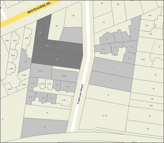
|
|
|
Subject site
|
|
21 Objector Properties
(1 outside of map)
|
é
North
|
BACKGROUND
History
There was a previous application
(WH/2011/962) on the portion of the site at 48 Whitehorse Road and 4 Frankcom
Street, for development of a medical centre, also including land at 50 and 52
Whitehorse Road, Blackburn. This planning application was refused and the
decision was not appealed.
The Site and Surrounds
The subject site comprises 4-6
Frankcom Street, 48A Whitehorse Road and the rear section of 48 Whitehorse
Road. Combined, the subject site is generally rectangular in shape with a
frontage of 33.8 metres to Frankcom Street, a maximum depth of 65 metres and an
overall site area of 2,692 square metres. Part of the remaining land on
48 Whitehorse Road will remain vacant and is to be consolidated with 50
Whitehorse Road.
The land is currently used for
residential purposes and is occupied by single and double storey dwellings and
assorted outbuildings. The dwelling at the front of 48 Whitehorse Road,
which straddles the boundary of the site affected by this application, is
double storey. A number of trees are present on 4-6 Frankcom Street, and
the applicant’s Arborist Report advises that this includes a number of
weed species and most are in poor condition.
The site has an east to west
orientation and slopes from the rear (north-west corner) down towards the
Frankcom Street (south-east corner) by approximately 4.1 metres.
Frankcom Street is a dead end road
on the south side of Whitehorse Road with no court bowl or T-head.
Frankcom Street is approximately 180m in length and terminates at the
Lilydale-Belgrave train line to the south. Access to and from Frankcom
Street is left in from Whitehorse Road and left out only as Whitehorse Road is
divided at this point.
Built form in Frankcom Street
consists of a mixture of single and double storey dwellings and multi-dwelling
developments. Abutting the site to the north is a single storey brick dwelling
with an attached carport. The adjoining property to the south is a
development comprising two single storey brick dwellings. To the west is
a development comprising two single storey brick dwellings. To the east
are two multi-dwelling developments, with threeand four dwellings
respectively. Abutting the eastern side of 48 Whitehorse Road is a single
storey dwelling.
Planning Controls
The State Planning Policies at
Clauses 11 (Settlement), 12 (Environmental and Landscape Values), 15 (Built
Environment and Heritage) and 16 (Housing) aim to encourage consolidation of
existing urban areas while respecting neighbourhood character, and facilitate
sustainable development that takes full advantage of existing settlement
patterns through encouraging higher density development near public transport
routes.
The Local Planning Policies at
Clauses 21.06 (Housing) and 22.03 (Residential Development) have identified the
subject site as being located in a Substantial Change Area. The Substantial
Change Area is expected to make a significant contribution to increases in
housing stock. The Local Planning Policies have also identified the site
being located in Garden Suburban Precinct 13.
Clause 22.04 (Tree Conservation)
outlines the importance of retaining significant trees within a development
where it is practical to do so, the minimum distances between trees and
buildings/hard surfaces and suggested design responses for hard surface areas
close to retained trees.
A permit is
required under Clause 32.07-4 (Residential Growth Zone) to construct two or
more dwellings on a lot. The relevant purposes of Clause 32.07 include to
provide housing at increased densities in buildings up to and including four
storey buildings, and to encourage a diversity of housing types in locations
offering good access to services and transport. Schedule 2 to the zone
varies a number of the standards in Clause 55 (Two or more dwellings on a lot)
of the Whitehorse Planning Scheme (ResCode).
Clause 52.06 (Car parking) seeks to
ensure the provision of an appropriate number and the efficient use of car
parking spaces that are of a high standard, creates a safe environment for
users, and enables easy and efficient use without adversely affecting the
amenity of the locality. A permit is required to reduce the number of car
spaces under Clause 52.06-3.
Clause 55 (ResCode) is the primary
assessment tool to ensure that developments of two or more dwellings provide
reasonable standards of amenity for existing and new residents.
Clause 65 provides guidelines that
must be considered before deciding on an application to ensure the proposal
will produce acceptable outcomes. These guidelines include the State and
Local Planning Policy Framework, the purpose of the zone, the orderly planning
of the area and the effect on the amenity of the area.
PROPOSAL
The application involves the
demolition of all existing dwellings and the construction of twenty (20)
dwellings comprising 18 three-storey dwellings and 2 double-storey
dwellings.
The composition of dwellings
includes four, two-bedrooms and 16, three or four bedrooms, in three
formats. The 16 three storey dwellings with living areas on the first
floor, a bedroom and garage on the ground floor, and additional bedrooms on the
second floor; 2 double storey with living rooms on the ground floor; and two
double storey dwellings starting at the first floor with access from the ground
level car park by a staircase only.
Dwellings 1 and 20 provide a
frontage to Frankcom Street. The remaining dwellings are accessed via a
common pathway along the northern and southern boundaries. The existing
vehicle crossovers are to be reinstated and a new double width vehicle
crossover and driveway will be located centrally within the site providing
access to all car parking spaces.
A total of 38 on-site car parking
spaces, including 36 resident and two (2) visitor spaces are provided.
This is a shortfall of two visitor spaces; therefore approval is sought for a
reduction under Clause 52.06-3.
The architectural style proposed is
contemporary with a flat roof form. The variation of materials includes
face brickwork, render, aluminium and metal sheet cladding and timber
cladding. The maximum building height is 9.8 metres.
A 1.2 metre high rendered brick
pier and steel picket fence is proposed along the frontage.
CONSULTATION
Public Notice
The application was advertised by
mail to the adjacent and nearby property owners and occupiers and by erecting
notices to the Frankcom Street and Whitehorse Road frontages. Following
the advertising period there has been 22 objections received from 21 objector
properties.
The issues raised are summarised as
follows:
Neighbourhood Character
· Visual
Bulk
· Loss
of open areas
· Inadequate
setbacks
Parking
· Insufficient
amount
· Consideration
should be given to basement to reduce building height
Traffic
· Insufficient
room for emergency vehicles
· Waste
collection
Density
· Capacity
of the street to absorb a doubling in the number of households from the
cumulative effect of all the redevelopment.
Loss of vegetation
· Potential
impact on birds
Amenity
· Overlooking
· Overshadowing
· Potential
impact on solar panels
· Noise
Other
· Loss
of high quality agricultural land
· Precedence
On the 26 October 2016 the
applicant submitted revised plans following discussions with Council
officers. These plans have not been formally substituted and the
advertised plans remain the decision plans for the purposes of determination of
this application. The changes which can be included by way of condition
of any approval include:
· Relocating
the pedestrian path against the building to provide for wider landscaping beds
adjacent to the boundary line.
· Design
details to improve dwelling entry identification when viewed from east at
ground level, and vertical gardens.
· Design
detail to first floor of Dwellings 3, 4, 7, 8, 13, 14, 17 and 18 to improve
articulation of the north and south elevations, in the form of light weight
perforated window frames.
Consultation Forum
A Consultation Forum was held on 14
February 2017, chaired by Councillor Massoud, attended by the applicant, the
property owner, the applicant’s planning representative, and 12
objectors. One party who has not lodged a written objection was also in
attendance.
Five additional objections were
tabled at the forum, reiterating the issues listed above (bringing the total
number of objections received to 22).
All issues were discussed with no
resolution of the issues.
Referrals
Internal
Engineering and Environmental
Services Department
· Transport
Engineer
The proposal was referred to
Council’s Transport Engineers, who do not support the reduction of
on-site visitor parking and have recommended to increase the aisle width
between the garages from 5.8 to 6.4 metres.
· Waste
Engineer
The proposal was referred to
Engineering and Environmental Services who require waste management to be
managed internally on site by private collection. A revised waste
management plan can be required by conditions on any approval issued.
· Assets
Engineer
The proposal was reviewed by
Council’s Asset Engineers who offered no objection subject to the
inclusion of standard conditions on any approval issued.
Planning Arborist
The proposal was reviewed by
Council’s Consulting Arborist who offered no objection to the proposal
subject to the inclusion of tree protection conditions on any approval issued.
DISCUSSION
State and Local Planning Policy
The proposal is consistent with
State and Local Planning Policies which seek to ensure housing stock matches
changing demand by widening housing choice; encourage the development of
well-designed medium-density housing that makes better use of existing infrastructure;
and that new development respects the neighbourhood character and appropriately
responds to its landscape, valued built form and cultural context.
Clause 21.06 (Housing) includes the
site in an area of Substantial Change. Clause 22.03 (Residential Development)
identifies the site as being in a Garden Suburban Area in which significant
redevelopment is expected to occur. The clause also identifies the site as
being in Neighbourhood Character Precinct Garden Suburban 13 in the Whitehorse
Neighbourhood Character Study 2014. Within this precinct properties in the
substantial change area with good access to train stations at Laburnum and
Blackburn will accommodate more dwellings with more compact siting, while
retaining space for landscaping, including planting of large trees.
Design and Built Form
Achieving a preferred character is
guided by Clause 21.05 (Environment), 22.03 (Residential development) and the
design response objectives contained in the City of Whitehorse,
Neighbourhood Character Study 2014 (the Study) Precinct Guidelines.
Under Clause 22.03, the site is located within Precinct 13, which includes the
following preferred character:
· The
area will retain its classic garden suburban characteristics of low set,
pitched roof dwellings set in spacious garden settings, with a backdrop of
large native and exotic trees. The established pattern of regular front and
side setbacks from both side boundaries will be maintained, allowing sufficient
space for planting and growth of new vegetation.
· Infill
development including unit developments will be common, however new buildings
and additions will be set back at upper levels to minimise dominance in the
streetscape. Low or open style front fences will provide a sense of openness
along the streetscape, and allow views into front gardens and lawn areas.
· Areas
within the Blackburn / Megamile West Urban Design Framework and nearby
(Substantial Change) will undergo change to accommodate new medium density
dwellings with more compact siting, while retaining space for landscaping
including trees.
The zone and
local planning policy framework provide clear direction that the level of
development and degree of change will be ‘substantial’. These
policies do not seek to retain an existing character; rather promote a
substantially different character that can support developments up to 14.5
metres in height. Given the current zone and policy position, the
development provides an appropriate response, notwithstanding that in the short
term the proposed built form may be different to the current built form of the
immediate area.
The overall
height of the proposed development is 9.8 metres, which is substantially less
than the recommended height within the Residential Growth Zone. Upper
levels are recessed to reduce their profile to the streetscape. The first
floor provides side and rear setbacks of between 2 metres (Dwellings 10 and 11)
and 4.5 metres with the upper level (second floor) setback between 4.5 and 6.1
metres. This level of recession provides an appropriate transition in
height, mindful of the more traditional scale of development within the
immediate context.
The front
setback of 6.4 metres does not meet Standard B6 (Street Setback), however is
considered reasonable given the site’s inclusion within a Substantial
Change area where more ‘compact siting’ is anticipated. There
remains sufficient opportunity across the wide street frontage for the planting
of new canopy trees to create a new garden setting. The low and open
style fencing will also allow for filtered views into the front setback area.
The
building’s frontage is well designed to create a transition between the
public and private space. There are direct pedestrian entrances for
Dwellings 1 and 20, with clearly defined pedestrian pathways adjacent to the
north and south boundaries for the remaining dwellings. Amendment to the
pathway design will assist in expanding side boundary landscape areas.
The design is
contemporary, with a flat roof form and application of a variety of materials
including face brickwork, concrete render, aluminium cladding and black metal
framed windows. The articulation is assisted by modulated forms with
staggered setbacks, which provide visual interest and reduces the perception of
visual bulk. The architectural treatment of the front façade also
reduces the visual profile of the garage entry fronting Frankcom Street through
the inclusion of windows and a mix of face brickwork and aluminium
cladding. The garages are also designed to incorporate internal upper
level balconies to Dwellings 1 and 20.
The application proposes a building
site coverage of 69.7%, which does not meet the maximum 60% site coverage
required to satisfy Standard B8. Given the site’s location in a
designated ‘substantial change’ area which is anticipated to experience
a greater level of development, the variation to this Standard is considered
acceptable. The development proposes a permeability of 21.56%, which
meets the minimum of 20%.
Offsite Amenity
· Overlooking
The ground
level windows are generally screened by existing paling fencing and it is
proposed to add a 400mm high trellis over the boundary fencing to prevent views
from some of the bedroom windows. Along the north and south elevations,
habitable room windows and balconies are setback 4.5 metres or greater.
To the west, the first floor habitable windows are setback 2.9 metres. At
the Consultation Forum the applicant agreed to screening of the west facing
windows by way of condition on any approval issued.
With regard to
the north and south facing boundary interfaces, habitable room windows and
balconies at the first floor have been setback a minimum of 4.5 metres from the
common boundary, which is consistent with the equitable development principles
applied in ‘Substantial Change’ areas and therefore screening is
not required. The second floor is further recessed again. In
addition both adjoining properties have driveways abutting the subject land,
which results in no overlooking of secluded private open space within 9 metres,
complying with Standard B22 of ResCode. The south elevation of Dwelling
11 and the north elevation of Dwelling 10 have no windows at the first floor,
and the second floors of these dwellings are very well recessed
· Overshadowing
The application
includes shadow diagrams which demonstrate compliance with the overshadowing
objective of Clause 55.
Onsite Amenity
· Secluded
private open space (SPOS).
Dwellings 10
and 11 are provided with ground level areas of secluded private open space
totalling 25 square metres. Given these dwellings are small, two bedroom
units, this size is acceptable. Dwellings 2 to 8 and 13 to 19 are
provided with a first floor balcony (each at 15.73 square metres) located
internally (in-between the rows of dwellings), with smaller alternate, north or
south facing balconies. Dwellings 1 and 20 have balconies orientated
towards the street, with dwellings 9 and 12 facing towards the rear
(west). These balconies meet the 8 square metre minimum and achieve a
width of at least 1.6 metres.
Whilst the
south-facing balconies will be affected by shadows during the day, these
dwellings (13 to 19) have the alternate option of the internal facing balconies
that comply with Standard B29 of ResCode for south setback of secluded private
open space from walls to the north.
· Access
to daylight
All habitable rooms have direct
access to daylight and ventilation. It is noted that the orientation of
the site has resulted in a proportion of the proposed apartments being oriented
southwards, where solar access will be reduced, however these apartments have
north-facing alternatives via the provision of the internal balcony layout.
Car Parking and Traffic
Under Clause 52.06, the parking
requirement for the proposed development is 40 car spaces. The proposed
provision of 38 spaces results in a statutory shortfall for two (2) visitor
spaces.
Whilst the applicant has provided a
Traffic Engineering Assessment (Traffix Group, June 2016) stating that
there is sufficient space on the street to accommodate the short fall of
visitor parking, this has not been supported by Council’s Transport
Engineers. In addition the objectors have concerns regarding the need for
one side of the street to be clear of vehicles on garbage collection day,
consequently it is considered appropriate to include a condition on any
approval issued requiring full provision of on-site visitor parking. This
will necessitate reconfiguration of a minimum of two of the dwellings from 3 or
4 bedroom to 2 bedroom to provide the ability for two additional on-site car
spaces to be allocated to visitor parking.
Currently double garages are
provided for Dwellings 1 to 8 and 13 to 20, with single spaces for Dwellings 9,
10, 11 and 12. These are all contained within the building and are
accessed by a centralised internal access way. The garages have internal
dimensions of 5.5 by 6 metres with an access aisle of 5.8 metres. Whilst
Council’s Transport Engineers have suggested increasing the aisle width
to 6.4 metres the swept path diagrams provided by Traffix Group demonstrate
that no more than one corrective manoeuvre is required for entry and exit
movements. Such corrective movements are permitted by Australian Standard
AS2890.1-2004 for long term (resident) parking. The garage opening width
at 5.4 metres (wider than standard) also improves the garage access.
Council’s Transport Engineers
advised that the level of traffic generated from the development is unlikely to
significantly impact the local road network including nearby
intersections.
Landscaping
Although the subject site contains
mature vegetation, a large number of these trees are weed species, or in fair
to poor health and are not considered worthy of retention. The subject
site and immediately surrounding properties are not subject to any tree
protection controls.
A condition of the permit will
require the submission of a landscape plan which will provide for four new
canopy trees within the front setback area, a canopy tree at the western end of
the site adjacent to the accessway, and screen planting adjacent to the north
and south boundaries.
Whilst in the short term there will
be a loss of vegetation, over time new landscaping that forms part of the
proposal will see the regeneration of the landscaping, including tree canopy
over the site. This will complement the garden character of the area and in
time subject to appropriate species selection will offer habitat opportunities
for birds and wildlife. This is consistent with preferred neighbourhood
character objectives to maintain and enhance garden settings.
Objectors Concerns not
Previously Addressed
Effect on the character of the
area from doubling the number of dwellings in the street – The site
is located in a substantial change area, which is reflected in its zoning and
the proposed development is consistent with both the preferred character of the
area as expressed by the zone and local planning policy. The entirety of
Frankcom Street is located in a Residential Growth Zone and there is an expectation
housing densities within the street will change over time.
Rubbish collection – Council’s
Engineering and Environmental Services Engineers do not support waste
collection from the street and require the Waste Management Plan to be modified
to show on-site collection from within the basement, and the provision of swept
path diagrams. Waste collection is to be by private contractor.
Conditions to this effect can be placed on any approval issued.
Increase in noise - It is
anticipated that any noise from the occupants of the dwellings will be typical
of residential uses in the area. All proposed noise sources, such as mechanical
plant, are away from bedrooms of immediately adjacent existing dwellings and
are required to comply with Standard B24 (Noise impacts), and emissions must
continue to comply with EPA regulations.
Noise during the construction
period is considered reasonable in association with the development of
residential land for residential purposes, will be for a limited time frame,
and must comply with relevant EPA regulations. A condition requiring the
provision of a Construction Management Plan will be included on any approval
issued.
Impact to solar panels – The
shadow diagrams demonstrate very little impact to adjoining areas of secluded
private open space and no impact to the roofs of adjacent dwellings where solar
panels are commonly located.
Consideration should be given to
a basement to reduce building height – Council is obligated to
consider to the application that has been put before it. A change of this
nature is beyond the scope of what could reasonably be addressed by way of
condition and would require a complete re-design. As previously discussed
the height is well within the permissible height limits for the zone.
Insufficient room for emergency
vehicles – The street width adjacent to the subject site is of a
standard road width, being 7.5 metre from kerb to kerb. Council’s
Transport Engineers have not objected to the proposal on this basis.
Loss of agricultural land
– This area is a designated growth zone, designed to support increased
residential densities. Agriculture is not an ‘as of right’ use in
this zone.
CONCLUSION
The proposal for the construction
of a part-two and part-three storey building comprising 20 dwellings is an
acceptable response that satisfies the relevant provisions contained within the
Whitehorse Planning Scheme, including the State and Local Planning Policies,
the Residential Growth Zone, Schedule 2 and Clause 55, ResCode.
A total of 22 objections were
received as a result of public notice and the issues raised have been discussed
as required.
It is considered that the
application should be approved.
Attachment
1 Advertised
Plans ⇨
2 Post
Advertising Discussion Plans ⇨
Ordinary Council Minutes 20
March 2017
Strategic
Planning
9.1.6 Strategic
Planning Update
FILE NUMBER: SF10/90
SUMMARY
This report outlines progress with key strategic planning
projects from September 2016 to date. The report recommends that this
update report be acknowledged.
background
Council’s Strategic Planning
Unit undertakes a range of projects that respond to the strategic planning
needs of Whitehorse, updates the Whitehorse Planning Scheme and manages
projects to proactively plan for future improvement, development opportunities
and protection of important features and places within the City.
DISCUSSION
The following is a summary of the
current status of key projects being undertaken through the Strategic Planning
Unit. The last update to Council was provided at its meeting on 19
September 2016.
Key planning scheme amendments and their status
include:
C157 – Whitehorse Heritage
Review 2012
The amendment proposed to introduce
heritage overlays to places identified in the 2012 Whitehorse Heritage
Review. The heritage places consist of 29 individual places and 3
precincts. Following exhibition of the amendment in 2014 and an independent
Panel hearing in March 2015, Council considered the Panel report at its meeting
on 20 July 2015. Council adopted Part 1 of the amendment comprising 27
places and removed four of the heritage places (including the Burvale
Hotel/Motel in Vermont South) from the amendment. Part 1 of the amendment
was gazetted on 4 August 2016 with changes including approval of a heritage
overlay on the Burvale Hotel/Motel site.
On 23 February 2017, the Minister
for Planning gazetted Amendment C212 under section 20(4) of the Planning and
Environment Act 1987 to delete the Heritage Overlay from the Burvale Hotel
/ Motel site, effectively reversing the Minister’s delegated decision
made approximately six (6) months earlier.
Part 2 of the amendment comprising
the former ATV-0 television studios in Forest Hill was deferred to allow further
investigation into the Panel’s recommendations for this property, but was
subsequently considered by Council at its meeting on 18 July 2016 where the
heritage overlay was adopted for the site. The Minister for Planning is
yet to make a decision on Part 2 relating to the former ATV-0 television
studios.
Amendment C175 – Box Hill
Metropolitan Activity Centre Built Form Guidelines
The draft Box Hill Metropolitan
Activity Centre Built Form Guidelines (the Guidelines) were prepared in
response to the identified need to provide guidance on the built form and
public realm in key areas of Box Hill. Amendment C175 proposes to
implement the findings of the Guidelines by introducing a new Schedule 6 to the
Design and Development Overlay and applying it to various precincts within the
Activity Centre, rezoning various parcels of land as recommended in the Box
Hill Transit City Activity Centre Structure Plan adopted in 2007 (the
Structure Plan) and making minor changes to local planning policy to reference
the Guidelines.
The draft Guidelines and Amendment
C175 were exhibited from Thursday 16 February 2017 until Friday 17 March 2017.
Drop-in information sessions were held during the exhibition period on Saturday
25 February in the Box Hill mall and Tuesday 7 March at the Box Hill Town Hall.
Officers are reviewing submissions received and will present them to a future
Council meeting for consideration.
C186 – Rezoning of
remaining Commercial 2 Zone properties in Box Hill Metropolitan Activity
Centre
At its meeting on 15 February 2016,
Council resolved to request an amendment under Section 20(2) of the Planning
and Environment Act 1987 (allowing for exemption from the normal amendment
notification) to rezone 10 properties in the Box Hill Structure Plan
area that are zoned Commercial 2. The rezoning of these properties to
either the Commercial 1 Zone or the Mixed Use Zone rectifies identified
inconsistencies between the land uses encouraged by the Structure Plan and the
land uses allowed under the Commercial 2 Zone that currently applies to the
land parcels. Council adopted the amendment at its meeting on 15 August
2016. The amendment was approved by the Minister for Planning on 6 October 2016
and was gazetted into the Whitehorse Planning Scheme on 20 October 2016.
C189 – Corrections
Amendment
The Whitehorse Planning Scheme is
regularly reviewed and updated. Typically this will occur as part of a formal
review of the planning scheme as required under the Planning and Environment
Act 1987 and subsequent to preparation of the Council Plan as required
under the Local Government Act 1989.
However there are minor errors,
updates and anomalies that can be dealt with as required. Amendment C189
proposes 59 corrections which include rezoning land that has been incorrectly
zoned, removing the Vegetation Protection Overlay from properties where trees
have been removed and minor amendments to maps, ordinance or incorporated
documents to correct errors or anomalies. The amendment was exhibited under
Section 20(2) of the Planning and Environment Act 1987 in late 2016. No
submissions were received and at the meeting on 30 January 2017 Council
resolved to submit the amendment to the Minister for Planning for approval. The
amendment was submitted for approval on 6 February 2017.
Amendment C191 – Municipal
Wide Significant Landscape Overlay
Trees are
the most significant determinant of the character of the various areas within
the City of Whitehorse, with tree canopy covering a significant proportion of
the municipality. Council undertook a municipal-wide tree study, as a key
initiative in the 2015/2016 budget. The Study investigated the importance
of vegetation, in particular tree cover, to the municipality, examined the
existing strategic framework for vegetation controls and scoped options to
protect and enhance tree canopy, as development and future growth inevitably
occurs over time.
At its meeting of 18 July 2016,
Council resolved to adopt the Whitehorse Tree Study Final Options Report and
seek authorisation from the Minister for Planning to prepare and exhibit an
amendment to the Whitehorse Planning Scheme to implement the recommendations
from the Tree Study.
Amendment C191 seeks to implement
the recommendations by extending the Significant Landscape Overlay to all
residential land in the municipality. Officers are currently preparing
Amendment C191 and will submit this to the Minister for Planning for
authorisation when finalised.
Amendment C194 – Combined
Planning Scheme Amendment and Planning Permit for 517–521 Cambridge
Street and 2-8 Oxford Street, Box Hill
The Amendment is a combined
planning permit application and planning scheme amendment under Section 96A of
the Planning and Environment Act 1987. The amendment proposes to rezone
the land at 517 and 519-521 Station Street Box Hill from the Public Use Zone to
the Mixed Use Zone and rezone the land at 2-8 Oxford Street Box Hill from the
Residential Growth Zone to the Mixed Use Zone. The amendment also proposes to
introduce an Incorporated Document for 517 and 519-521 Station Street, Box
Hill.
The draft planning permit for the
517 and 519-521 Station Street site is seeking the approval for building and
works for the construction of buildings of up to 18 storeys including rooftop
plant plus up to 3 levels of basement car parking. The proposal comprises
retail premises, office, restricted recreational facility (gymnasium), medical
centre, accommodation, serviced apartments, child care facility, a reduction in
the standard requirements for car parking facilities and alteration of access
to a road in a Road Zone, Category 1.
At the Council meeting on 20
February 2017, Council resolved to seek authorisation from the Minister for
Planning to prepare and exhibit the amendment.
Activity Centres
Officers continue to implement
actions from adopted structure plans and urban design framework plans for
activity centres in the municipality. A monitoring framework for
implementation of the plans has also been established and is periodically
updated.
Burwood Heights Activity Centre – Former Burwood
East Brickworks Site
The Development Plan Overlay (DPO)
that currently applies to the former brickworks site at 78 Middleborough Road,
Burwood East requires that a development plan be prepared to Council’s
satisfaction before planning permits can generally be granted for the
development. The development plan is intended to guide future planning
permit applications for each stage of this major development and assessment of
those applications.
At its meeting on 18 July 2016 and
having placed the draft development plan on display as required under the DPO,
Council considered community comment and resolved to approve a development plan
for the site, subject to a number of conditions. Once these conditions
have been satisfactorily addressed by the proponent, Frasers Property Australia,
the development plan can be endorsed.
Parallel to this process, several
planning permit applications have been lodged with Council for
assessment. Applications must be generally in accordance with the
approved development plan and are exempt from third party notification.
A substantial amount of work is
being undertaken by officers to facilitate the above processes with Frasers
Property to ensure that the outcomes will be consistent with Council’s
objectives and the community’s aspirations.
Subject to approval of planning
permit applications, Frasers Property anticipates that initial civil works will
commence on site in the first half of 2017.
Box Hill Metropolitan Activity Centre (MAC)
Actions relating to the Box Hill
MAC are aligned with the Box Hill Structure Plan and other strategic documents
and include:
· Urban
design, landscape and strategic planning advice on major developments;
· Engagement
with relevant departments across the organisation and external stakeholders to
progress the Structure Plan;
· Preparation
of planning scheme amendments to progressively implement the Structure Plan and
other strategies; and
· Undertaking
further studies and guidelines to support implementation of the Structure
Plan. Currently this includes:
o Implementation of
Guidelines to give clearer direction on built form outcomes envisaged for
precincts within the Structure Plan. Amendment C175 (refer above) to implement
built form guidelines completed exhibition on Friday 17 March 2017.
o Preparation of Public
Realm Treatment Guidelines for Box Hill to provide a strategic vision for
treatment of the public realm in response to new development in areas of the
MAC that are experiencing rapid change. The Guidelines will be informed
by the Box Hill Urban and Landscape Design Guidelines that were developed in
2010 for the core of Box Hill and are intended to assist in the coordinated
delivery of a higher quality public realm and streetscape environment as
development progresses.
Nunawading Activity Centre
Amendment C155 to rezone the former
Daniel Robertson brickworks site at 56 – 74 Station Street, Nunawading
from Industrial 1 Zone to Residential Growth Zone and Mixed Use Zone and to
introduce an Environmental Audit Overlay and the Development Plan Overlay (DPO)
to the site was gazetted on 10 March 2016. As required under the DPO, a
development plan has been lodged with Council for consideration. Officers
have been progressing discussions with the proponent and the development plan
with a view to a future report to Council to seek approval to display the plan
for community comment. However, the proponent has lodged an application
for review with the Victorian Civil and Administrative Tribunal to determine
whether the development plan in its current form is acceptable for display,
pursuant to the planning scheme.
Built Environment Awards Program (BEAP)
The Built Environment Awards
Program advocates for good planning and design outcomes including building,
landscape and urban design projects, and recognises the people who contribute
towards them. The Program consists of an Awards event and Educational event on
alternate years.
The Built Environment Awards will
be held at Deakin University on Wednesday 24 May 2017, Deakin University is the
event sponsor.
Nominations for the Awards closed
on 10 March 2017 and judging of nominations will be held on Wednesday 19 April
2017. The judging panel comprises the Mayor, two Councillors, Council officers
and two guest judges.
Award categories represent
development activity in Whitehorse and include:
- Single
house project – New Dwelling
- Single
house project – Renovated Dwelling
- Multi-residential
project (unit, townhouse or apartment)
- Commercial
or retail project
- Institutional
project
- Landscape
design project
- Heritage
project
- Other
awards include the Mayor’s Award, People’s Choice Award and the
newly introduced Sustainability Award.
More information can be found at http://www.whitehorse.vic.gov.au/Built-Environment-Awards.html
Heritage
Heritage Assistance Fund:
The Fund provides grants up to
$1,000 to eligible owners and occupiers to assist with the ongoing maintenance
of their heritage properties. Applications for the 2016/2017 round of
funding closed on 16 September 2016 and were considered by the Heritage
Steering Committee on 17 October 2016. Forty-eight (48) applications were
received for the 2016/2017 year, of which 22 were successful.
Heritage Adviser:
Council’s Heritage Advisor
continues to provide specialist advice to the Strategic Planning Unit. Responsibilities
of the Advisor include responding to planning application referrals from the
Statutory Planning Unit, liaising with the community and other departments of
Council on heritage matters, undertaking heritage investigations and helping to
assess Heritage Assistance Fund applications.
Other Major Projects
The Neighbourhood Project
The City of Whitehorse was selected
as one of three metropolitan Councils as part of the Neighbourhood Project; a
pilot project which is a practical program to make community-led placemaking
easier for councils and communities. Led by CoDesign Studio with support from
the Myer Foundation, it is part of the Resilient Melbourne Strategy and is a 12
month program of mentoring, training and funding to facilitate the delivery of
three projects by the community.
Council, community leaders and the
wider community collaborated to transform Council land into active spaces over
the last two weeks of January with three community-led activations, these
being:
· The
Art Project – Over 80 community members of diverse backgrounds and ages
came together in the Box Hill Mall to contribute to the creation of two SAORI
weaving pieces. The varied colours, textures and shapes within the weavings are
a visual representation of community coming together to create the pieces.
· Greening
the Mall – More than 30 community leaders and volunteers constructed and
planted out four wicking beds in the Box Hill Mall with edible plants. The team
from Very Edible Gardens and Permablitz supervised the day and engaged the
volunteers and many passer-by’s with an informative workshop.
· Front
Lawn Festival – On the evening of Saturday 21 January, the front lawn of
the Box Hill Town Hall was transformed for a night of open-air entertainment.
Community members of all ages and backgrounds came together to lounge on
beanbags, listen to live music, dine from food trucks and watch a sunset
screening of ‘Babe’.
The final stage of the project, to
‘evaluate and scale’ the activations, is underway and involves
planning for long term change and looks at how community-led activation of
spaces can be refined and replicated beyond the Neighbourhood Project pilot
project.
As part of the Project in December
2016, Council hosted a meeting for the Myer Foundation and CoDesign Studio who
fund and facilitate the Neighbourhood Project respectively.
State Government Projects
Healesville Freeway Reservation
The current state government gave
an election undertaking for the Healesville Freeway corridor in Whitehorse to
be open space. Land in the reserve that is currently owned by VicRoads is in
the process of being transferred to the Crown and is proposed to be managed by
Parks Victoria as open space. As part of this process, the Department of
Environment, Land, Water and Planning (DELWP) has prepared a Concept Plan.
The Concept Plan provides the strategic justification for the development of
community recreation opportunities along the corridor and an off-road shared
trail network. There are a number of stakeholders adjoining the reservation
that have an interest in particular land parcels for future community and
recreation purposes.
Broader community consultation on
the project was undertaken during September 2016 by DELWP through CoDesign
Studio. Outcomes from the community consultation were reported to
DELWP’s Stakeholder Reference Group for the project (SRG) at its meeting
on 29 November 2016. The subsequent Concept Plan was presented to the SRG
on 14 March 2017.
Managing Residential Development
Advisory Committee
The Minister
for Planning appointed the Managing Residential Development Advisory Committee
to consider the application of zones that provide for residential development
(residential, commercial, mixed use etc). Council officers prepared a
submission in March 2016 to the Advisory Committee based on the
Committee’s Terms of Reference. The Advisory Committee conducted public
hearings on 17 days in a 5 week period in April and May 2016, with Council
officers presenting a verbal submission on 11 May 2016. A number of resident
groups and residents also presented to the Committee. The Advisory
Committee’s report was released on 11 March 2017 together with further
reforms proposed to the residential zones.
Environmentally Sustainable Development
The Minister
for Planning approved the Environmentally Sustainable Development (ESD) Local
Planning Policy for the Whitehorse, Moreland, Port Phillip, Stonnington,
Banyule and Yarra Planning Schemes in November 2015. In the Minister's approval
letter, it was specified that each council will be required to review the
effectiveness of the policy in 12 months and provide a written report to the
Department. DELWP has been liaising with the six council's on a framework
to monitor and review the policy. Each Council’s local ESD policy will
expire on 31 December 2017 or earlier if it is superseded by an equivalent
provision at State level in the Victoria Planning Provisions.
The six
Councils received a commendation for the ESD policy in the category of ‘Improving
Planning Processes’ at the Planning Institute of Australia Awards
last November. This was followed by the six Councils receiving the award for
the policy in the Sustainability category at the LGPro Awards for Excellence in
February 2017.
Bushfire
Management Overlay
The current
state government is preparing a bushfire mapping and policy update to planning
schemes across the State. This project is a key element of the State
Government’s commitment to implementing the recommendations of the 2009
Victorian Bushfires Royal Commission. In the Victorian planning system, the
Bushfire Management Overlay (BMO) maps area of Victoria that are at risk of
extreme bushfire. If the State government amendment proceeds, properties
in Whitehorse in the vicinity of the Mullum Mullum Creek corridor may have the
BMO applied.
CONSULTATION
Community consultation is an
integral part of all strategic planning projects. The level and type of
consultation will be extensive and varied, depending on the nature and
complexity of each project. While community consultation adds to the
depth of projects it can also extend their timeframe in some instances.
This update report on strategic
planning projects is prepared every six (6) months covering periods ending in
March and September. This is followed by a summary in the Whitehorse News
on a selection of projects of interest to the community.
FINANCIAL
IMPLICATIONS
All of the projects require
resources and funding for tasks including consultation, preparation, exhibition
and consideration of amendments, consultant advice and investigations,
including government processes eg: panel hearings etc. Adequate funding
for the projects has been provided in the recurrent budget.
POLICY IMPLICATIONS
The undertaking of strategic
planning projects is consistent with the Council Plan 2016 – 2020
in terms of project outcomes and the consultation involved.
conclusion
The report provides an update on
key strategic planning projects. It is recommended that Council
acknowledge the report.
9.2.1 Contract
Extension Receival, Processing & Management of Green & Timber Waste at
the Whitehorse Recycling & Waste Centre
SUMMARY
Council provides a wide range of recycling and waste
services to the community at the Whitehorse Recycling and Waste Centre. One of
the most popular services is the collection, mulch processing and removal of
the green waste from the landfill process. Bark King Group Pty Ltd has been
providing an excellent service for the past four years. It is appropriate to
consider an extension of Contract for the provision of – Receival,
Processing and Management of Green and Timber Waste at the Whitehorse Recycling
and Waste Centre currently held by The Johnson Family Trust, trading as Bark
King Group Pty Ltd, for a period of 1 year commencing on 27 May 2016 on a
schedule of rates basis.
|
Council
Resolution
Moved by Cr Bennett,
Seconded by Cr Liu
That Council extend Contract 12043 for the Receival,
Processing and Management of Green and Timber Waste at the Whitehorse
Recycling and Waste Centre with Bark King Group Pty Ltd (ABN 49 629 868 816),
of 54 Fussell Road Montrose 3765 Victoria, trading as Bark King Group Pty
Ltd, for a period of 1 year, commencing on 27 May 2017 on a schedule of rates
basis.
Carried Unanimously
|
background
This contract is for the receival,
mulching and management of all green waste and timber at the Whitehorse
Recycling and Waste Centre (Centre). The Centre receives up to 15,000 tonnes of
green waste per year, including all green organics such as branches, grass
clippings, weeds, vines, and hard and soft
timbers.
The contractor is required to
supply a full time supervisor 7 days a week on site to check material as it is
being brought in to the Centre to ensure that it is contaminant free and manage
the unloading area keeping it safe and accessible for customers to unload. This
level of supervision must be present during the operating hours of the Centre.
Most importantly the contractor is
responsible for providing all plant, labour, materials and equipment required
for the proper and safe receival, mulching and management of green waste coming
into the Centre and the loading and transportation of the material from the
Centre to the contractors processing facility.
On 27 May 2013, Council awarded
Contract 12043 for the Receival, Processing and Management of Green and Timber
Waste at the Whitehorse Recycling and Waste Centre to The Johnson Family Trust,
trading as Bark King Group Pty Ltd following a public tender process. The
original 3 year term of the Contract expired on 27 May 2016. The Contract
allows for 2 x 1 year extensions at Council’s discretion, of which the
first 1 year extension is coming to completion.
DISCUSSION
Bark King Group Pty Ltd has delivered
an excellent standard of services over the initial term and first year
extension of the Contract with its performance having been closely monitored
and measured through regular communication and meetings. Bark King Group Pty
Ltd has successfully managed the increase in tonnages of green organics and
timbers and has met all OH&S criteria over the initial term and first year
extension of the contract.
Bark King Group Pty Ltd has agreed
to accept Council’s offer to extend the Contract under the current
Contract terms and conditions for the second year extension, subject to Council
approval. The extension of this Contract will negate the need to conduct a new
tender process for these services.
CONSULTATION
Council’s General Manager
Infrastructure and relevant Centre staff have been consulted with regards to
the extension of this Contract.
FINANCIAL IMPLICATIONS
The contract for the provision of
Contract 12043 for the Receival, Processing and Management of Green and Timber
Waste at the Whitehorse recycling and Waste Centre will be extended for the
agreed schedule of rates, for a period of 1 year, with this being the final
extension offered under the current contract.
In 2015/16 Financial year the
expenditure on this service was $ 747,348.00 with a surplus of $1,106,594.00.
Current volumes and expenditure are
forecast to provide a similar surplus to Council in the final year extension of
the contract
There will be no increase by Bark
King to the current schedule of rates.
The costs incurred under this contract
will be charged to the relevant recurrent budget.
Ordinary Council Minutes 20
March 2017
9.2.2 Tender
Evaluation Report (Contract 20011) Provision of Consultancy Services: Quantity
Surveyor
SUMMARY
Part of Council’s building
asset management program, from time to time, requires the services of a
Quantity Surveyor. It is proposed to appoint a new panel of Quantity Surveyor
consultants to provide Council with Quantity Surveying services for a range of
planned future building projects.
Following the public tender
process, a comprehensive evaluation and assessment was undertaken and three
Quantity Surveyor consultants are now recommended for appointment to form a
preferred supplier panel.
|
Council
Resolution
Moved by Cr Munroe,
Seconded by Cr Cutts
That Council:
1. Accept the tenders and sign
the formal contract documents for Contract 20011 for the Provision of
Consultancy Services: Quantity Surveyors, received from:
· MBMpl
Pty Ltd of 323 Princes Highway, Rockdale, NSW, 2216 (ABN: 74 099 962 231).
· Muller
Australia of Suite 1, 19 Kendrick Street, The Junction, NSW, 2291
(ABN:
33 650 179 041).
· Turner
& Townsend Pty Ltd of Level 13, 140 Creek Street, Brisbane, QLD, 4000
(ABN: 84 115 688 830).
on a Schedule of Rates basis
for a period of 3 years commencing on 3 April 2017.
2. Authorise the Chief
Executive Officer to award an extension of this contract, subject to a review
of the Contractor’s performance and Council’s business needs, at
the conclusion of the initial 3 year contract term.
Carried
Unanimously
|
BACKGROUND
Council owns a large number of
buildings and is responsible for maintaining these buildings to ensure the
level of service delivered meets community and user expectations. Funding for
these capital projects is allocated from the annual Capital Works Program. Most
projects require the services of a range of consultants including Quantity
Surveyors to deliver the new, upgraded or refurbished facilities.
A panel of Quantity Surveyor
consultants was first established in 2012 with an initial three year contract
followed by a further two year contract extension. The purpose of this tender
is to appoint a new panel of Quantity Surveyor consultants to provide Council
with quantity surveying services for a range of planned future building upgrade
projects located throughout the municipality.
The establishment
of a new panel of Quantity Surveyors will continue to assist with the timely
delivery of building capital works projects and will continue to enable Council
to comply with the requirements of the State Government’s “best
value” purchasing legislation and Council’s Procurement Policy.
It is planned to let a three year
Contract, with the option for a two year extension to be exercised at the Chief
Executive Officer’s discretion.
DISCUSSION
Tenders were advertised in The Age
newspaper on Saturday 3 December 2016 and closed on Friday 6 January 2017.
Seven tenders were received.
The tenders were evaluated against
the following criteria:
· The Tenderer’s experience in the provision of
similar services;
· The Tenderer’s capacity to provide the Services;
· The Consultant’s capacity and experience in
providing Value Engineering on projects;
· Financial benefit to Council;
· Occupational Health & Safety and Equal Opportunity
(Pass/Fail); and
· Financial viability (Pass/Fail).
The previous contract contained a
panel of four Quantity Surveyor consultants. Based on Council Officers use of
the previous panel and reviewing the forward Capital Works Program, it has been
determined that a panel of three Quantity Surveying consultants is sufficient
to adequately service Council needs.
Following a
comprehensive evaluation of the tenders, including business viability checks,
referee checks and interviews with the selected Quantity Surveyors, the tenders
received from the Quantity Surveyors MBMpl Pty Ltd, Muller Australia and Turner
& Townsend Pty Ltd are considered to provide the best service and value for
money for this Contract:
References for the
selected Quantity Surveyors have been checked and confirmed as having the
relevant skills and experience required for this contract. The preferred
tenderer’s business viability has been checked and is considered
financially viable.
CONSULTATION
Relevant staff from Building
Project Management and Facilities Maintenance has been consulted about the
appointment of this panel.
FINANCIAL IMPLICATIONS
The contract for the Provision of
Consultancy Services: Quantity Surveyors is based on a Schedule of Rates. The
tendered rates will be subject to rise and fall adjustments based on the
Melbourne All-groups index numbers at each anniversary date of the Contract.
Quantity Surveyors are generally
engaged on a rate per cost plan and the assessment of the financial criteria
was based on the average fee for each of the four cost plans for projects with
a value between $300k and $5m. The total average was then aggregated and a
total average fee was applied as the tendered sum.
Based on the Council’s forward
Capital Works Program, the estimated expenditure under this contract over the
initial 3 year contract term is $120,000 including GST. This expenditure will
increase to approximately $200,000 including GST if the option to extend the
contract is exercised for two years.
The costs incurred under this
contract will be drawn annually from project budgets approved by Council as
part of the annual Capital Works Program. Contract administration and project
financial management will be undertaken by the Building Project Management team
within the Built Infrastructure Department.
9.3.1 National
Partnership Agreement - Universal Access to Early Childhood Education
FILE NUMBER: SF16/710
ATTACHMENT
SUMMARY
To report to
Council on the status of the current National Partnership
Agreement – universal Access to Early Childhood Education and to
recommend that Council join with the MAV in advocating to the Commonwealth
Government in support of a new National Partnership Agreement between both
governments.
|
Council
Resolution
Moved by Cr Liu, Seconded
by Cr Stennett
That Council:
1. Join with the MAV in advocating to the
Commonwealth Government on the need for a new National Partnership Agreement
- Early Childhood Education & Care Services beyond the expiry of the
current agreement on 31 December 2017.
2. Write to all local commonwealth and state
members of parliament outlining its position on this matter.
3. Write to the MAV advising them of the above
resolutions.
Carried
Unanimously
|
background
In late 2008, the commonwealth, state and territory
governments signed a National Partnership Agreement on Early Childhood
Education ("Universal Access").
The partnership committed all Australian governments to
achieving, by 2013, universal access to early childhood education programs for
all children in the year before school, delivered by university qualified early
childhood teachers, for 15 hours a week, 40 weeks a year (600 hours per year).
The objective of the partnership is based on accepted international research
into the long term advantages afforded to children;
“There is significant benefit for children in
attending a quality early childhood education program. Increasing kindergarten
hours and access to programs in a range of different early childhood settings
further increases that benefit. The Effective Provision of Pre-school Education
(EPPE) study in particular demonstrated this.
The implementation of universal access to early childhood
education in the year before school:
· Recognises that quality early childhood education programs
improve children's learning, health and behaviour with positive impacts
extending into adult life.
· Enables children and families to have access to a high
quality development program in a range of settings such as public, private and
community-based kindergartens and child care services.
· Supports a successful transition to formal schooling.
· Supports planning for integrated service systems.”[1]

For early childhood education services the change typically
meant an increase in the provision of education services (delivered by a degree
qualified early childhood educator) from 400-480 hours per year to 600 hours
per year. For many non-sessional kindergarten services it also meant the
employment of at least one degree qualified early childhood educator (Councils
WELS centres have engaged fully qualified kindergarten teacher since the early
part of the previous decade). These changes also coincided with the
introduction of a national quality framework designed to improve and
standardise the quality of education and care services delivered by all
licensed early childhood education and care services.
In the early part of this decade, these changes required
significant adaption in both the physical layout of some facilities and in the
structuring of programs provided to children.
The National Partnership included $955 million in
commonwealth funding provided to the states and territories over the five years
to 30 June 2013. Part of Victoria's allocation was initially used as grants for
modifications to ECEC buildings, the rest for implementation programs
(including quality reforms) and then funding the cost of the additional hours.
This objective was largely achieved in 2013.
To date, the Commonwealth Government has not
committed to funding a new partnership agreement with the states and
territories beyond the end of this year (worth about $450M per year). With the
federal budget for 2017/18 approaching this has created concern within the
sector that the 2008/09 reforms of the early childhood education and care
sector in Australia may not be supported into the future.
Ultimately,
a decision to not fund the continuance of the reforms will likely see the
rollback of the universal access program and the quality reform agenda. Alternatively,
the families of 74,000 Victorian pre-schoolers will face untenable fee
increases of up to $2,000 per year per child to maintain existing service
levels.
The MAV
is communicating this concern to the commonwealth government to ensure funding
is continued:
‘Request
a) That
the Australian Government retains its commitment of minimum $450m for Universal
Access to Early Childhood Education in its 2017/2018 budget;
b) That
this amount be allocated as recurrent funding - annually indexed and linked to
growth to ensure continuity and stability for preschool education for
Australian children in the year prior to school entry.’[2]
Additional information from the MAV on this matter is
included as an attachment.
DISCUSSION
It is recommended that Council
provide advocacy support on this matter in what is likely to be a statewide
campaign and adopt the recommendations contained in this report.
CONSULTATION
Consultation in relation to the
development of this report was undertaken with officers from the MAV and with
officers from Council’s Health and Family Services Department.
FINANCIAL
IMPLICATIONS
The cost to
Council of the government not funding a continuance of the program would be
between $40,000 to $60,000 per annum. This funding is Based on a per capita
funding formulae for children attending formal kindergarten services at
Council’s five WELS centres.
POLICY IMPLICATIONS
The recommendations contained in
this report accords with key strategies contained in Council’s;
· Municipal
Early Years Plan (2014-2018)
· The
Whitehorse Community Health & Wellbeing Plan 2017-21
Attachment
1 National Partnership Agreement -
Early Childhood Education & Care ⇨ 
NB: Cr
Davenport requested that his vote against Item 9.3.1 be recorded in the
minutes.
9.3.2 Public
Health and Wellbeing Act - Refusal
FILE NUMBER: 16/746
SUMMARY
To recommend that Council ratify the preliminary decision
of Council officer’s delegate to refuse registration of a Prescribed Accommodation (Rooming House) under the Public Health
and Wellbeing (PHW) Act 2008.
background
The proprietor (operator) of a prescribed accommodation
under the PHW Act 2008 is required to register that accommodation with
Council. An application for the issue, renewal or transfer of a registration
must be made to Council with the relevant fees.
Council may refuse to renew a
registration on the grounds that the operator/premises: -
· Does
not comply with any requirements of the Act or regulations
· Fails
to comply with conditions
· Ceases
to operate as a prescribed accommodation
· There
is a risk to the health of persons if the registration is renewed
A rooming house located at 79 Elgar Road, Burwood and
registered with Council as a prescribed accommodation under the PHW Act
2008 was issued a Building Order in May 2016 by Council’s Planning and
Building department. Criminal charges were
subsequently brought against the owner for breaches under the Building Act
1993 and the Planning and Environment Act 1987. These criminal
charges relate to failing to comply with a Building Order, specifically dealing
with fire safety requirements at the premises and failing to comply with the
Whitehorse Planning Scheme.
DISCUSSION
An application to renew the
registration as a prescribed accommodation under the PHW Act 2008 for
this calendar year was received by Council in December 2016.
In light of the non-compliances with the PHW regulations
2009 and pending charges pursuant to the Building Act 1993 and the Planning
and Environment Act 1987 a delegated decision was made to refuse the
application to renew the registration as a prescribed accommodation for 2017. A notice dated 10 February 2017 was subsequently issued to
the proprietor stating Council’s intention to refuse the renewal of
registration on the grounds of non-compliance with the PHW Regulations and
posing a risk to the health of persons if the registration is renewed. A decision
to refuse to renew a registration under the PHW Act 2008 must be
ratified by Council under the requirements of the said Act.
Once the decision is ratified by Council the premises will
not be registered for prescribed accommodation and will be immediately issued
with a Prohibition Notice to prohibit the use of the premises as prescribed
accommodation.
Council’s Planning and Building Department undertook
a successful prosecution against the owner of the property on the 23 February 2017. The owner (accused) entered a plea
of guilty which resulted in a fine and conviction. The court issued an Order
directing the owner comply with the Building Order which includes reverting the
dwelling back to a 1A building and consequently to cease using the dwelling as
a rooming house within 30 days.
CONSULTATION
Council’s Planning and
Building Department were consulted in coordinating enforcement activities and
legal advice was sought and provided by Council’s solicitor.
FINANCIAL IMPLICATIONS
Nil
POLICY IMPLICATIONS
Nil
Ordinary Council Minutes 20
March 2017
9.3.3 Morack
Golf Course Strategic Plan
FILE NUMBER:
ATTACHMENT
SUMMARY
To consider the implementation of a
Strategic Plan for Morack Public Golf Course.
background
Morack Public Golf Course (Morack)
is an 18-hole (par 70) golf course situated in Morack Road Vermont South. The
facility also features a 17 bay floodlit driving range, two practice putting
greens, a sealed and lit car park, public toilets, a pro-shop, clubhouse and
outdoor barbeque and seating area.
The water supply for the course is
based upon a 50 million litre dam. Water is also pumped from the Dandenong
Creek so as to maintain adequate supply from the dam. The dam services an
extensive automatic watering system designed to keep the tees, green and
fairways as green as possible throughout the summer months. The dam together
with the billabong alongside the creek and the water feature beside the 2nd
fairway attracts a large number of water birds and are features of the course.
The views of the Dandenong Ranges
combined with the undulating layout, natural bush along the Dandenong Creek and
"an ongoing" landscaping and tree planting program, ensures the
course as one of the most picturesque in the Melbourne Metropolitan area.
The golf course is managed under a
third party arrangement with a contractor appointed to operate the pro shop,
and collect greens fees and other income under a revenue share arrangement.
There is a separate contract for the turf maintenance at the golf course.
A small timber clubhouse facility
built in 1970 is situated adjacent to the pro shop which currently accommodates
five resident golf clubs with a combined membership of 425 players.
The clubhouse’s is not fit
for purpose and therefore not suitable for use by external groups and corporate
functions.
The pro shop and driving range was
constructed in the late 1980’s and funded by a previous Golf Course
Professional in return for a long term lease.
A Morack Public Golf Course
Strategic Plan was developed and adopted by Council in July 2000. In 2002 a
Morack Public Golf Course Master Plan was then developed detailing a new course
layout to address safety issues and improve playability.
Council has invested $1.9mil in
course improvements since 20012/13 and ongoing works is required to bring the
course up to a standard that is comparable to Morack’s immediate
competitors.
DISCUSSION
The Game of Golf - Current
Status
There have been significant challenges
within the golfing industry over the past 10-15 years with participation rates
declining as a result of competition from other leisure activities and the
impacts of unpredictable weather patterns due to climate change.
Council’s Recreation Strategy
Plan (2015-2024) identifies golf as a popular activity within the municipality
with 7% of respondents indicting they participate. The catchment area for
golf is approximately a 10km radius. According to the Australian Bureau of
Statistics (ABS), there are 600,000 residents living within Morack’s
catchment with an expected increase of 17.9% to 700,000 by 2031. Based on
current participation rates, there are 34,000 golfers over the age of 15 within
the catchment which provides opportunity to attract new golfers to the
course.
The Australian Sports
Commission’s Participation in Exercise, Recreation and Sport
annual report indicates that an estimated 1.17 million people or 6.7% of the
Australian population aged over 15 play golf with 60% of those public or social
golfers. Total golf participation has fallen by 12% since 2002 however
participation levels have been relatively stable since 2008.
A number of trends are emerging
within the golf industry including:
· Emergence
of short game golf formats such as adventure golf.
· Golf formats such as big hole golf and foot golf that
compliment other golf activities.
· Driving
range activities adding entertainment elements.
· Tuition
enhancement through golf academy/ improvement centres.
· Enhanced
golf retail and food and beverage offerings.
· On
line golf bookings.
· More
sophisticated database/ customer relationship management.
· Viewing
golf not just as a sporting activity but as an entertainment activity e.g. Big
screen TVs and other entertainment elements.
Challenges and Issues for
Morack
With key competitors including
Ringwood and Dorset Golf Courses (Maroondah City Council) and Glen Waverley
Golf Course (City of Monash) having made significant investments in recent
years to their respective courses, Morack is under increasing pressure to
attract and retain players.
Enhancements to the playability and
overall course standard need to be addressed to bring the course up to the
level that is comparable to competitor courses. These include:
· Improved
drainage to enable year round use.
· Consistent
grass coverage with warm season grasses on all fairways.
· Reconstruction
of tees and greens.
· Creation
all weather access paths to enable cart usage year round.
The Morack facilities that support
the course are outmoded with an old timber clubhouse, rudimentary outdoor
seating area and limited food and beverage offering. The facility lacks spaces
that are inviting for patrons to stay around and socialise after a game of golf
or a hit on the range therefore limiting secondary spend.
Surveys conducted of the customer
base confirm that the course is attracting predominantly an older market with
families and children under represented, which suggests that the product
offering lacks appeal to the broader community.
A point of difference Morack has
compared to many of its competitors is the undulating and picturesque layout
and unique natural bush setting along Dandenong Creek.
Appointment of Well Played
& Crafter Mogford
Responding to these challenges,
Whitehorse Council engaged consultants - WellPlayed Golf Business Consultancy
(Well Played), in conjunction with Crafter + Mogford Golf Strategies to develop
a Strategic Plan for Morack to guide its future direction.
The key objectives
of the project were:
· To
research and identify the changing demographic trends and leisure needs of the
Whitehorse community and their impact on the golf course.
· To
identify emerging trends within the golfing industry and adapt any such trends
to the development of recommendations within the Strategic Plan.
· To
review the current condition, capacity, and appropriateness of the existing
facility features at Morack Public Golf Course with consideration to the future
needs of the community.
· To
provide a clear position for an informed decision on the future direction of
the Morack Public Golf Course for the City of Whitehorse to ensure long term
sustainability.
· To
recommend innovative approaches to increasing participation and the return on
investment for Council.
Well Played
undertook a situational analysis including a review of Council’s
strategic framework; extensive stakeholder consultation; detailed site assessment;
review of local population trends; comparing Morack’s
performance to similar facilities within Melbourne; obtaining customer
and local community insights; together with a review of Morack’s current
operations.
The consultation undertaken within
the community was extensive and included the following activities:
· A
customer and community survey ‘Have Your Say’ was advertised
through the following mediums – at the golf course, Council’s
customer service centres, on line golf member database, Whitehorse News, and a
direct mail out to local residents. The survey yielded a total of 306
responses.
· Meetings
conducted with representative members of the five resident golf clubs.
· One
on one interviews held with representatives from the two golf course
contractors (Golf Services Management and Australian Golf Course Management).
· Meetings
with Council officers.
· Individual
consultations with local secondary schools that are frequent users of the
course.
Attachment 1 contains the Morack
Public Golf Course Strategic Plan.
Findings
A review of golf course operations
and benchmarking established the following:
· The
financial return to Council is significant. Since 2002/03, $15.6 mil in gross
income has been earned with a net operating contribution of $4.2
mil. Capital expenditure over the same period is around $1.9 mil
(representing 45% of Morack’s net contribution).
· Morack’s
total visitation was well above the mean with benchmarked facilities due to the
presence of a driving range, however the course attendances are declining.
· Morack’s
driving range is close to capacity with waiting lists for bays during peak
times.
· Whilst
the golf retail sales per visitor are high amongst benchmarked facilities, the
merchandising and pro shop infrastructure were not best practice due to the
layout of the facility and the age of the building.
· Food
and beverage sales were poor. The limited offer and lack of indoor/outdoor
eating spaces detrimentally impact sales.
· The
presence of a strong and loyal club member base.
Attachment 2 provides the detailed
benchmarking analysis.
In terms of the course quality and
presentation, 53 issues and opportunities were identified within the Strategic
Plan including drainage and impact on playability in winter, turf coverage of
fairways, lack of all-weather paths and improvements to tees and greens. While
some course improvements recommended have been undertaken over the past 10 to
15 years, further investment by Council is required to bring Morack up to the
standard of competitor courses.
The overall findings from the
Strategic Plan report support Morack Public Golf Course as an important
community facility that provides recreation opportunities for the residents of
Whitehorse and for people from across the south eastern region.
To remain viable Morack must
broaden its appeal to better attract women, families, diverse groups and
younger generations. Council could also consider new business models to ensure
greater facility visitation and revenue diversification i.e.: short format and
other golf entertainment participation options.
While there are key challenges
facing golf in the market place and from local competitors, Morack brings to
Council an annual net operating surplus of between $200,000 to $300,000 and
approximately 100,000 patrons per year.
Some of the trends or opportunities
emerging within the golf industry include the resurgence of Adventure (mini)
Golf which is highly attractive to families and young children. Driving range
developments are being more heavily influenced by technology with a move
towards a more interactive and entertainment focussed golfing experience where
golf balls are tracked and players record scores with each shot.
Both of these elements offer an
opportunity to attract other market segments beyond the traditional golfer and
also provide a pathway within golf facilities for beginners and young children
to eventually transition to on course golf (9 or 18 holes).
Recommendations
Based on the issues and
opportunities arising from the detailed situational analysis as part of the
strategic planning process, and with reference to the key challenges, three
strategic directions have been developed.
1. Active
Community – maintaining and growing facility visitation and access.
2. Evolving
Infrastructure – maintaining and developing relevant facilities in
connected and sustainable open space.
3. Healthy
Performance – delivering financial sustainability and economic benefit.
Each of the above strategic
directions responds to and aligns with Council’s Strategic Framework.
Improvement and development actions have been identified under each of the
strategic directions in the form of an Implementation Plan and are incorporated
into a Concept Plan with the following recommendations:
· Improvement
works to the golf course involving a rolling program over 9 years.
· Upgrade
to the driving range to 25 bays and incorporating a ‘premium bay’
concept.
· Development
of a new golf pavilion incorporating a golf shop, new modern café change
facilities and multipurpose space.
· A
new feature entry leading to the golf pavilion and golf staging areas
(including new golf cart parking areas).
· Development
of a new 18-hole premium mini- golf facility.
· Expansion
of car parking spaces.
· Replacement
of the course maintenance facility.
· New
golf cart storage and environmental wash down area.
An estimated total investment of $7,877,500 (excluding GST)
would deliver the above improvements.
Three options were considered in
developing 10 year financial projections for Morack. They were:
1. Do
Nothing (No investment in the golf course).
2. Course
Improvements Only.
3. Full
Implementation of the Concept Plan.
A summary of the three scenarios is
as follows:
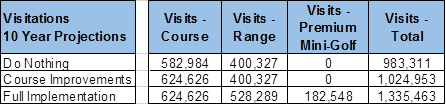
Source: WellPlayed analysis, Annual visitation estimate
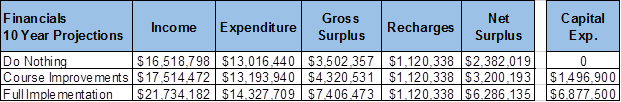
Source: WellPlayed analysis, 10 Year financial projections
The assumptions for the above financial modelling are based
on conservative estimates taking into consideration historical course data,
industry trends and the current commercial climate.
In summary, the ‘Do Nothing’ approach will see
course visitation revenue decline by 3% and
net surpluses to Council decline by 30% over
10 years. Alternately, a ‘Course Improvements Only’ approach will
result in minor annual growth in course rounds.
It is recommended that Council adopt the Full Implementation
option. It will enable Morack to grow visitation by 50% to over 150,000 per
annum, and increase and diversify the sources of revenue resulting in
significant growth in net surpluses from $250K to over $950K per annum ensuring long term sustainability of
the service. The impact on operating surpluses for the three scenarios over a
10 year period is shown in the graph below.

The ‘Adventure Golf’ and ‘Driving
Range’ components will provide the greatest return on investment for
Council. The capital investment for the 18 hole adventure golf component is
estimated at $1.1mil and is expected to generate $225,000 per annum (Council
share) and deliver a payback (based on a conservative case which is more modest
than the original WellPlayed projection) of 5 years. The conservative case
estimate is more modest than the original WellPlayed projection. The driving
range is estimated to cost $1.215mil and it is expected to generate a 49%
growth in visitations and approximately $200,000 additional revenue per annum.
Importantly, from a social benefit perspective both
components would create a service with a much broader community appeal
inclusive of families and young children and provide important pathways for
golf as a lifelong activity.
Funding and Timing of Works
The WellPlayed Strategic Plan identifies as a potential
scenario for third party investment to fund the $5.6mil estimated cost of the
new golf pavilion, driving range expansion, new mini golf facility temporary
course maintenance staff building and cart storage. From discussions with
the current course operator, they were ‘lukewarm’ in their response
regarding possible investment, particularly given the uncertainty of the
current environment.
The commitment of such significant funds presents a high
level of risk for the operator therefore they would seek a larger proportion of
the revenues to achieve a suitable return on investment. This would result in
Council forgoing the majority of any future operating surpluses.
The current Long Term Financial Plan suggests that Council
has the capacity to fund a project of this scope and magnitude. This would
enable Council to continue to receive the annual net operating surpluses
generated by the enhanced service.
The funding of the course improvements and maintenance
facility components would be unlikely to attract interest from a third party.
With respect to the timing of the works, it is recommended
that the redevelopment works including the golf pavilion and precinct,
expansion of the driving range, construction of the adventure golf facility and
golf cart storage building should be undertaken in the same year as opposed to
staging the works over a number of years.
The rationale behind this is as follows:
· There
will be significant business disruption when the works are undertaken so are
best confined to a single timeframe.
· If
works were staged over a number of years the continual disruption would have a
greater impact on attendances and business viability.
· The
overall project costs to Council would be greater with multiple set up costs
and the costs of construction increasing at approximately 3.5 to 4% per annum.
It is proposed that such works be undertaken in 2020/21.
With regards to the course improvements works, these would
be undertaken over a 9 year period commencing 2017/18. By staggering the works
over this period it will minimise the disruption to the course as golfers will
tend to go elsewhere if large components of the course are out of play at any
one time. Also, the majority of works particularly involving turf will have to
be undertaken over the growing season being the peak summer
period.
CONSULTATION
Well Played undertook extensive
community consultation which is detailed within the Discussion Section of the
report.
FINANCIAL IMPLICATIONS
The estimated cost of $7,877,500 for
the implementation of the Concept Plan is detailed in the table below. An
overview of such financial implications, estimated costs and timings has been
provided earlier in the report.
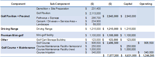
A consultant (DJK Consulting) was
engaged to undertake an independent financial analysis of the assumptions and
financial projections contained within the Strategic Plan. The consultant
expressed the view that “The Strategic Plan developed by Well Played
was an excellent document inclusive of significant levels of evidentiary and
supporting information. It’s financial data and modelling is detailed and
comprehensive with very transparent and generally objective assumptions”.
Attachment
1 Morack Golf
Course Strategic Plan ⇨
2 Benchmarking
Competitor Analysis ⇨
9.4.1 Tender
Evaluation Report (Contract 12/12516) – Recruitment Services
FILE NUMBER: 12/12516
SUMMARY
To recommend the acceptance of
an offer received from MAPS Group Limited, trading as Procurement Australia to
appoint the below suppliers, as Council’s preferred suppliers on a
Schedule of Rates basis for a period of 3 years and to consider the estimated expenditure
over the life of the contract. The offer is to appoint 38 Agencies (see
Appendix A), as Council’s preferred supplier of recruitment and
associated services.
|
Council
Resolution
Moved by Cr Stennett,
Seconded by Cr Ellis
That Council
1. Accept
the recommendation from MAPS Group Limited (ABN 45 058 335 363), trading as
Procurement Australia and appoint the preferred tenderers as Council’s
preferred suppliers of recruitment and associated services, under Contract
12/12516 on a Schedule of Rates basis for a period of 3 years.
2. Accept
the recommendation from MAPS Group Limited (ABN 45 058 335 363), trading as
Procurement Australia and appoint 38 Agencies under Contract 12/12516.
3. Authorise
the Chief Executive Officer to award an extension of this contract, subject
to a review of the performance and Council’s business needs, at the
conclusion of the initial 3 year contract term.
Carried
Unanimously
|
Whitehorse City Council along with
other Council’s appointed Procurement Australia (PA), as its agent to
seek public tenders for the supply of Recruitment and Associated Services
(1912/0618). This contract can be extended for a further 2 years at
Council’s discretion.
Maps Group Limited trading as
Procurement Australia is a public company, which negotiates and facilitates
contracts for common use goods and services on behalf of its members.
Procurement Australia offers suppliers targeted access to the Government
purchasing sector through its tender process and marketing programs.
Procurement Australia suppliers are
authorised contractors who have tendered and been accepted to sell
goods/services through the Procurement Australia contracts. They consist
of a diverse group covering many market sectors and organisational profiles
including many high profile national and multinational brands.
DISCUSSION
PA advertised tenders in Herald Sun
newspaper on Saturday, 13 April 2016. Tenders were closed on Wednesday,
11 May 2016. 91 tenders were received.
The following
selection criteria were used to evaluate all the tender submissions:
· Compliance and Specification,
· Customer Focus,
· Contractors Performance,
· Corporate Social Responsibility Profile, and
· Price.
The tenders received from the
selected tenderers are considered to provide the best value for money for this
Contract. The Contractor may also offer a Member a special or discounted
sale if they choose.
The benefits for Council using PA
are:
· Lower
purchase prices resulting from the aggregation of individual councils
requirements i.e. substantially enhanced purchasing power;
· The
avoidance of our time and our tendering costs;
· The
introduction of competitive and value-added outcomes generally unachievable
through individual tendering;
· The
Agencies are required to provide suitably accurate reporting mechanisms to
capture all expenditure.
· The
Agencies will have quality systems, which will address issues including;
continuous improvement, contract reporting, risk management policies and
procedures, OH&S policies and procedures, quality checking and duty of
care.
The benefits for Council are:
· Agency
staff usage will be with a consistent group of suppliers and Council will be
able to accurately capture expenditure for the use of Agency staff.
· Strict
adherence with Local Government Act Section 186, probity and due diligence
procedures.
Once Council has established their
panel of providers and advised these suppliers via PA, we are then obliged to
use these suppliers subject to their satisfactory performance. The panel
arrangement does not prevent Council seeking alternative or additional
suppliers on resources or services outside the scope of the current agreement.
Council will also investigate over
the life of this tender future mechanisms to manage and control costs
associated with Agency staff including investigation of the agency broker
system introduced at the City of Melbourne.
CONSULTATION
Whitehorse City Council was one of
27 municipalities who appointed PA as its Agent to conduct the tendering
process.
FINANCIAL IMPLICATIONS
The acceptance of the offer
supplied by PA will provide price certainty over the initial three-year term of
the contract. However it does not fix the volume of use of any particular
provider.
The current budget process allows
for a mix of labour solutions to meet Council’s operational
requirements. This includes a mix of full-time, part-time, casual and
temporary staff. The budget process takes into account those Council
services that have mandatory requirements for staff ratio numbers to clients,
and the contingent nature of some of Council’s work, particularly as it
relates to Capital Works, by providing budgets for agency staff.
PA charges a commission of 1.5% for
purchases made under this contract. The commission is included in the
tendered price.
The costs incurred under this
contract will be charged to the relevant recurrent budgets.
Council spent approximately $2.6
million on agency staff last year out of a total “Employee Costs”
budget of $68 million (2015/2016) representing approximately 3.8% of total
Employee Costs for the year. This $2.6 million includes expenditure on
the cost of replacement staff in services that have service level agreements or
legal obligations (such as child-care). These services have a continuity
of service obligation to the community; have strict training and accreditation
requirements, and agency staff are therefore used on occasion to meet these
contingent needs
Appendix A
|
1
|
A Plus Labour Solutions Pty Ltd
|
|
2
|
All Best Care Ltd
|
|
3
|
Allstaff Australia Pty Ltd
|
|
4
|
Anzuk Education Services Pty Ltd
|
|
5
|
Astrum Recruitment Pty Ltd
|
|
6
|
Catalyst Consulting and Events Pty Ltd
|
|
7
|
Charterhouse Recruitment Pty Ltd
|
|
8
|
CK Recruitment Pty Ltd
|
|
9
|
Clarius Group Limited
|
|
10
|
Davidson Recruitment Pty Ltd
|
|
11
|
Denovo Consulting Groups Pty Ltd
|
|
12
|
Design and Build Recruitment Trust Pty
Ltd
|
|
13
|
Direct Recruitment Pty Ltd
|
|
14
|
Drake Australia
|
|
15
|
Enphatic Support Services Pty Ltd
|
|
16
|
Finite Group APAC Pty Ltd
|
|
17
|
GBS Recruitment Pty Ltd
|
|
18
|
Gforce Corporate and Finance Pty Ltd
|
|
19
|
Hays Specialist Recruitment Pty Ltd
|
|
20
|
Hoban Recruitment Pty Ltd
|
|
21
|
Horner Recruitment
|
|
22
|
Inner Northern Group Training
|
|
23
|
Inspired Management Pty Ltd
|
|
24
|
Mandy Nolton trading as Rec Relief
|
|
25
|
McArthur Pty Ltd
|
|
26
|
Michael Page International Pty Ltd
|
|
27
|
Morgan Consulting Australia Pty Ltd
|
|
28
|
Powerdata Group Consulting Pty Ltd
|
|
29
|
ProQuest Pty Ltd
|
|
30
|
Randstad Pty Ltd
|
|
31
|
Recruitment Solutions Group Pty Ltd
|
|
32
|
RNTT Pty Ltd trading
|
|
33
|
Slade Group
|
|
34
|
Programmed Skilled Workforce Ltd
|
|
35
|
Talent International Holdings Pty Ltd
|
|
36
|
SACS Consulting Pty Ltd
|
|
37
|
Tradewind Australia Pty Ltd
|
|
38
|
Work Solutions (Melb) Pty Ltd
|
9.4.2 Adoption
of Instrument of Appointment and Authorisation under the Planning and
Environment Act 1987
SUMMARY
The purpose of this report is to
recommend approval of an Instrument of Appointment and Authorisation under the
Planning and Environment Act 1987, from the Council to a position in the
organisation.
background
The proposed Instrument of
Appointment and Authorisation (pursuant to the Planning and Environment Act
1987) has been prepared following advice received from Council’s solicitors
Maddocks and is similar to that used by many Victorian municipalities.
The Instrument of Appointment and
Authorisation allows Council officers to conduct their normal business in
relation to enforcement of the Planning and Environment Act 1987 and to act
and commence proceedings in Council’s name.
These appointments
must be made by resolution of the Council; section 3(6) of the Local
Government Act 1989 defines ‘resolution of the council’ as
including a power exercised under delegation (ie: by the Chief Executive
Officer), however section 188 (2) (c) of the Planning and Environment Act
1987 prohibits authorisations being made under delegation.
The Instruments of Appointment and
Authorisation would come into force once the common seal is affixed to the Instrument.
CONSULTATION
Relevant staff including General
Manager City Development and Manager Planning and Building were consulted
during the preparation of the proposed Instrument of Appointment and
Authorisation.
FINANCIAL
IMPLICATIONS
There are no financial
implications.
POLICY IMPLICATIONS
There are no policy implications.
Whitehorse
City Council
Instrument
of Appointment and Authorisation
under
the Planning and Environment Act 1987
|
STAFF
|
|
Surname
|
Given
name
|
|
BROOKER
|
Shaan
|
|
UM
|
Dezarn
|
Instrument of Appointment and Authorisation
(Planning and Environment Act 1987)
In this
instrument "officer" means:
a) Shaan Brooker
b) Dezarn Um
By this
instrument of appointment and authorisation Whitehorse City Council:
a) Under section 147(4) of the Planning
and Environment Act 1987 - appoints the officer(s) to be an
authorised officer(s) for the purposes of the Planning and Environment Act
1987 and the regulations made under that Act; and
b) Under section 232 of the Local
Government Act 1989 authorises the officer(s) generally to institute
proceedings for offences against the Acts and regulations described in this
instrument.
It is declared that
this instrument -
a) Comes into force immediately upon its
execution; and
b) Remains
in force until varied or revoked.
This
instrument is authorised by a resolution of the Whitehorse City Council on
20 March 2017
|
THE
COMMON SEAL OF THE WHITEHORSE CITY COUNCIL was hereunto affixed this
20th
day of March 2017 in the presence of:
______________________
Councillor
______________________
Chief
Executive Officer
|
)
)
)
)
)
)
)
)
)
)
)
)
)
|
9.4.3 Delegation
Decisions January 2017
SUMMARY
The following activity was undertaken by officers under
delegated authority during January 2017.
|
DELEGATION
|
FUNCTION
|
Number for January
2016
|
Number for
January 2017
|
|
Planning and Environment Act
1987
|
Delegated Decisions
|
116
|
107
|
|
Strategic Planning Decisions
|
Nil
|
Nil
|
|
Telecommunications Act 1997
|
|
Nil
|
Nil
|
|
Subdivision Act 1988
|
|
12
|
13
|
|
Gaming Control Act 1991
|
|
Nil
|
Nil
|
|
Building Act 1993
|
Dispensations & Applications to
Building Control Commission
|
54
|
53
|
|
Liquor Control Reform Act 1998
|
Objections and Prosecutions
|
Nil
|
Nil
|
|
Food Act 1984
|
Food Act Orders
|
Nil
|
1
|
|
Public Health & Wellbeing
Act 2008
|
Improvement /
Prohibition Notices
|
Nil
|
2
|
|
Local Government Act 1989
|
Temporary Road Closures
|
1
|
5
|
|
Other Delegations
|
CEO Signed Contracts between $150,000 -
$500,000
|
1
|
2
|
|
Property Sales and Leases
|
10
|
12
|
|
Documents to which Council seal affixed
|
Nil
|
2
|
|
Vendor Payments
|
1134
|
917
|
|
Parking Amendments
|
2
|
17
|
|
Parking Infringements written off (not
able to be collected)
|
312
|
371
|
DELEGATED DECISIONS MADE ON PLANNING APPLICATIONS JANUARY
2017
All decisions are the
subject of conditions which may in some circumstances alter the use of
development approved, or specific grounds of refusal is an application is not
supported.
|
Appl No.
|
Dec. Date
|
Decision
|
Street
Address
|
Ward
|
Proposed Use or Development
|
Application
Type
|
|
17
|
09-02-17
|
CMP Approved
|
125-135 Rooks Rd, Nunawading
|
Springfield
|
CMP - Use and construction of 31
warehouses, reduction in car parking, and reduction in loading bay
requirments
|
CMP
Process
|
|
20
|
30-02-17
|
CMP Approved
|
15 Irving Ave, Box Hill
|
Elgar
|
Construction Management Plan
(Construction of a 9 storey building (plus basement carpark) comprising of
multiple dwellings; Reduction in car parking requirements for dwellings)
|
CMP
Process
|
|
1
|
06-02-17
|
Delegate Approval - S72 Amendment
|
11 Narallah Grv, Box Hill North
|
Elgar
|
Construction of two (2) double storey
side by side dwellings
|
Permit
Amendment
|
|
58
|
20-02-17
|
Delegate Approval - S72 Amendment
|
53 Florence Rd, Surrey Hills
|
Riversdale
|
Amendment to the endorsed plans for the
Construction of a single storey dwelling to the rear of the existing dwelling
(alterations to decking and garage)
|
Permit
Amendment
|
|
90
|
11-02-17
|
Delegate Approval - S72 Amendment
|
586 Whitehorse Rd, Mitcham
|
Springfield
|
Buildings and works for alterations and
additions to the existing building and alteration of access to a Road Zone,
Category 1
|
Permit
Amendment
|
|
128
|
10-02-17
|
Delegate Approval - S72 Amendment
|
48-50 South Pde, Blackburn
|
Central
|
Construct a double storey dwelling on a
lot with a Special Building Overlay
|
Permit
Amendment
|
|
242
|
23-02-17
|
Delegate Approval - S72 Amendment
|
18 Grandview Rd, Box Hill South
|
Riversdale
|
Amendment to endorsed plans to
WH/2014/242 for a redesign of all dwellings
|
Permit
Amendment
|
|
378
|
09-02-17
|
Delegate Approval - S72 Amendment
|
31 McCulloch St, Nunawading
|
Springfield
|
Construction of four double storey
dwellings
|
Permit
Amendment
|
|
Appl No.
|
Dec. Date
|
Decision
|
Street
Address
|
Ward
|
Proposed Use or Development
|
Application
Type
|
|
413
|
23-02-17
|
Delegate Approval - S72 Amendment
|
1/10 Middlefield Drv, Blackburn North
|
Central
|
Amendment to WH/2015/413/A (issued for
the construction of a dwelling extension (second storey) on a lot of less
than 300 square metres) comprising alterations to the first floor footprint
|
Permit
Amendment
|
|
435
|
16-02-17
|
Delegate Approval - S72 Amendment
|
269 Canterbury Rd, Forest Hill
|
Springfield
|
Use and development of land for a child
care centre and alteration of access to a road in a Road Zone, Category 1
|
Permit
Amendment
|
|
451
|
16-02-17
|
Delegate Approval - S72 Amendment
|
11 Aspinall Rd, Box Hill North
|
Elgar
|
Construction of two double storey
dwellings
|
Permit
Amendment
|
|
517
|
04-02-17
|
Delegate Approval - S72 Amendment
|
290-292 Middleborough Rd, Blackburn South
|
Central
|
Use and development of the land as office
and reduction in car parking requirements.
|
Permit
Amendment
|
|
564
|
04-02-17
|
Delegate Approval - S72 Amendment
|
14 Boyle St, Forest Hill
|
Springfield
|
Construction of one (1) double storey
dwelling to the rear of the existing dwelling
|
Permit
Amendment
|
|
715
|
09-02-17
|
Delegate Approval - S72 Amendment
|
12-14 Nelson Rd, Box Hill
|
Elgar
|
Amendment to Planning Permit WH/2015/715
issued for Construction of a Part 19, Part 20 storey building, comprising
dwellings, retail space and offices, with basement car park, use of the
building for accommodation (dwellings), and reduction of the parking
requirments of Clause 52.06 of the Whitehorse Planning Scheme to alter
configuration of apartments and parking layout.
|
Permit
Amendment
|
|
Appl No.
|
Dec. Date
|
Decision
|
Street Address
|
Ward
|
Proposed Use or Development
|
Application
Type
|
|
822
|
17-02-17
|
Delegate Approval - S72 Amendment
|
62 Surrey Rd, Blackburn North
|
Central
|
Construction of two (2) double storey
dwellings and create access to a road in a Road Zone, Category 1
|
Permit
Amendment
|
|
926
|
19-02-17
|
Delegate Approval - S72 Amendment
|
20 Varman Crt, Nunawading
|
Springfield
|
Buildings and works for the replacement
of an existing Concrete Batching Plant and display of associated business
identification signage
|
Permit
Amendment
|
|
1178
|
11-02-17
|
Delegate Approval - S72 Amendment
|
445 Canterbury Rd, Vermont
|
Springfield
|
Construction of two (2) double storey
dwellings
|
Permit
Amendment
|
|
1271
|
30-02-17
|
Delegate Approval - S72 Amendment
|
13 Harrison St, Mitcham
|
Springfield
|
Construction of two double storey
dwellings
|
Permit
Amendment
|
|
39
|
30-02-17
|
Delegate NOD Issued
|
1/29 Salisbury Ave, Blackburn
|
Central
|
Alterations and additions to six (6)
existing units
|
Residential
(Other)
|
|
42
|
24-02-17
|
Delegate NOD Issued
|
3A Forster St, Mitcham
|
Springfield
|
Construction of four double storey
dwellings
|
Multiple
Dwellings
|
|
46
|
18-02-17
|
Delegate NOD Issued
|
39 Boisdale St, Surrey Hills
|
Riversdale
|
Development of two double storey
dwellings
|
Multiple
Dwellings
|
|
118
|
09-02-17
|
Delegate NOD Issued
|
24 Park Rd, Surrey Hills
|
Riversdale
|
Construction of two double storey
dwellings
|
Multiple
Dwellings
|
|
184
|
10-02-17
|
Delegate NOD Issued
|
13 Highmont Drv, Vermont South
|
Morack
|
Construction of a second (double storey)
dwelling
|
Multiple
Dwellings
|
|
225
|
09-02-17
|
Delegate NOD Issued
|
9 Erasmus St, Surrey Hills
|
Riversdale
|
Construction of two double storey
dwellings
|
Multiple
Dwellings
|
|
234
|
10-02-17
|
Delegate NOD Issued
|
83 Dunlavin Rd, Mitcham
|
Springfield
|
Construction of a double storey dwelling
to the rear of the existing dwelling.
|
Multiple
Dwellings
|
|
256
|
09-02-17
|
Delegate NOD Issued
|
1 Middleborough Rd, Burwood
|
Riversdale
|
Construction of 11 dwellings comprising 8
three storey and 3 double storey dwellings with basement, removal of
easements, and alteration of access to a road in a Road Zone, Category
1
|
Multiple
Dwellings
|
|
Appl No.
|
Dec. Date
|
Decision
|
Street Address
|
Ward
|
Proposed Use or Development
|
Application Type
|
|
329
|
09-02-17
|
Delegate NOD Issued
|
2 Walsham Rd, Blackburn
|
Central
|
Buildings and works to construct a double
storey dwelling and removal of vegetation (Tree 7, Silky Oak) on proposed Lot
1
|
Special
Landscape
Area
|
|
330
|
09-02-17
|
Delegate NOD Issued
|
2 Walsham Rd, Blackburn
|
Central
|
Building and works to construct a double
storey dwelling on proposed Lot 2
|
Special
Landscape
Area
|
|
331
|
09-02-17
|
Delegate NOD Issued
|
2 Walsham Rd, Blackburn
|
Central
|
Buildings and works to construct a double
storey dwelling on proposed Lot 3
|
Special
Landscape
Area
|
|
511
|
30-02-17
|
Delegate NOD Issued
|
5 Anthony Crt, Burwood East
|
Morack
|
Construction of two double storey
dwellings
|
Multiple
Dwellings
|
|
566
|
12-02-17
|
Delegate NOD Issued
|
21 Churinga Ave, Mitcham
|
Springfield
|
Development of two (2) double storey
dwellings
|
Multiple
Dwellings
|
|
595
|
10-02-17
|
Delegate NOD Issued
|
97 Nelson Rd, Box Hill North
|
Elgar
|
Construction of three double storey
dwellings
|
Multiple
Dwellings
|
|
625
|
11-02-17
|
Delegate NOD Issued
|
657 Whitehorse Rd, Mitcham
|
Springfield
|
Construction of two (2) double
storey dwellings and creation of access to a road in a Road Zone Category 1
|
Multiple
Dwellings
|
|
628
|
31-02-17
|
Delegate NOD Issued
|
293 Elgar Rd, Surrey Hills
|
Riversdale
|
Construction of two double storey
dwellings and access to a road in a Road Zone Category 1
|
Multiple
Dwellings
|
|
651
|
30-02-17
|
Delegate NOD Issued
|
14 Box Ave, Forest Hill
|
Morack
|
Construction of three double storey
dwellings
|
Multiple
Dwellings
|
|
754
|
10-02-17
|
Delegate NOD Issued
|
123 Lake Rd, Blackburn
|
Springfield
|
Building an works for construction of
carport and verandah and hard surfaces.
|
Special
Landscape
Area
|
|
806
|
30-02-17
|
Delegate NOD Issued
|
16 Cadorna St, Box Hill South
|
Riversdale
|
Construction of two double storey
dwellings on a lot
|
Multiple
Dwellings
|
|
807
|
25-02-17
|
Delegate NOD Issued
|
41A Foch St, Box Hill South
|
Riversdale
|
Construction of a double storey dwelling.
|
Single
Dwelling
< 300m2
|
|
826
|
30-02-17
|
Delegate NOD Issued
|
390 Mont Albert Rd, Mont Albert
|
Elgar
|
Construction of one (1) double storey
dwelling to the rear of the existing dwelling
|
Multiple
Dwellings
|
|
Appl No.
|
Dec. Date
|
Decision
|
Street Address
|
Ward
|
Proposed Use or Development
|
Application
Type
|
|
945
|
04-02-17
|
Delegate NOD Issued
|
86-88 Broughton Rd, Surrey Hills
|
Riversdale
|
The development of four dwellings in two
double storey building. The subdivision of the land into four lots
|
Permit
Amendment
|
|
990
|
30-02-17
|
Delegate NOD Issued
|
14 Langford Ave, Mitcham
|
Springfield
|
Two unit development
|
Multiple
Dwellings
|
|
1036
|
09-02-17
|
Delegate NOD Issued
|
1 Verona St, Vermont South
|
Morack
|
2 lot subdivision
|
Subdivision
|
|
5
|
31-02-17
|
Delegate Permit Issued
|
22 Baratta St, Blackburn South
|
Central
|
Two (2) lot subdivision
|
Subdivision
|
|
9
|
31-02-17
|
Delegate Permit Issued
|
189 Springfield Rd, Blackburn North
|
Central
|
Two (2) lot subdivision
|
Subdivision
|
|
11
|
20-02-17
|
Delegate Permit Issued
|
604 Station St, Box Hill
|
Elgar
|
Extension of existing flue at the rear of
the site and construction of 2 x 2.1m high solid framed screen wall on the
rear northern and southern sides of the allotment
|
VicSmart –
General
Application
|
|
13
|
20-02-17
|
Delegate Permit Issued
|
56 Gardenia St, Blackburn
|
Central
|
Construct fence on front street alignment
|
VicSmart –
General
Application
|
|
24
|
31-02-17
|
Delegate Permit Issued
|
75 Box Hill Cres, Mont AlbertNorth
|
Elgar
|
Two (2) lot subdivision
|
Subdivision
|
|
25
|
31-02-17
|
Delegate Permit Issued
|
15 Naples St, Box Hill South
|
Riversdale
|
Two (2) lot subdivision
|
VicSmart - Subdivision
|
|
27
|
31-02-17
|
Delegate Permit Issued
|
11 Narallah Grv, Box Hill North
|
Elgar
|
Two (2) lot subdivision
|
Subdivision
|
|
28
|
25-02-17
|
Delegate Permit Issued
|
2/57 Orchard Cres, Mont AlbertNorth
|
Elgar
|
Removal of one tree from the courtyard of
a single storey dwelling
|
VicSmart –
General
Application
|
|
29
|
24-02-17
|
Delegate Permit Issued
|
13 Plymouth Crt, Nunawading
|
Springfield
|
Two (2) lot subdivision
|
Subdivision
|
|
33
|
24-02-17
|
Delegate Permit Issued
|
30 Melrose St, Mont AlbertNorth
|
Elgar
|
Two (2) lot subdivision
|
VicSmart - Subdivision
|
|
34
|
24-02-17
|
Delegate Permit Issued
|
1 Sylvan Crt, Forest Hill
|
Morack
|
Two (2) lot subdivision
|
Subdivision
|
|
44
|
11-02-17
|
Delegate Permit Issued
|
78 Brunswick Rd, Mitcham
|
Springfield
|
Construction of a double storey dwelling
at the rear of the existing dwelling
|
Multiple
Dwellings
|
|
64
|
06-02-17
|
Delegate Permit Issued
|
21 Barkly Trc, Mitcham
|
Springfield
|
Construction of six (6) double storey dwellings
|
Multiple
Dwellings
|
|
Appl No.
|
Dec. Date
|
Decision
|
Street Address
|
Ward
|
Proposed Use or Development
|
Application
Type
|
|
224
|
09-02-17
|
Delegate Permit Issued
|
660 Whitehorse Rd, Mont Albert
|
Elgar
|
Construction of one double storey
dwelling and extensions to an existing dwelling
|
Multiple
Dwellings
|
|
268
|
18-02-17
|
Delegate Permit Issued
|
76 Mahoneys Rd, Forest Hill
|
Central
|
6 lot subdivision
|
Subdivision
|
|
280
|
23-02-17
|
Delegate Permit Issued
|
13 Graham Place Box Hill
|
Elgar
|
Removal of a covenant
|
Subdivision
|
|
302
|
23-02-17
|
Delegate Permit Issued
|
83 Percy St, Mitcham
|
Springfield
|
Construction of two (2) double storey
dwellings
|
Multiple
Dwellings
|
|
306
|
10-02-17
|
Delegate Permit Issued
|
13 Middlefield Drv, Blackburn North
|
Central
|
Construction of a second (double storey)
dwelling
|
Multiple
Dwellings
|
|
307
|
23-02-17
|
Delegate Permit Issued
|
42 Roslyn St, Burwood
|
Riversdale
|
Construction of two double storey
dwellings
|
Multiple
Dwellings
|
|
356
|
20-02-17
|
Delegate Permit Issued
|
56 Hedge End Rd, Nunawading
|
Springfield
|
Construction of two double storey
dwellings
|
Multiple
Dwellings
|
|
362
|
25-02-17
|
Delegate Permit Issued
|
71 Churinga Ave, Mitcham
|
Springfield
|
Construction of two double storey
dwellings
|
Multiple
Dwellings
|
|
413
|
03-02-17
|
Delegate Permit Issued
|
7 Eckersley Crt, Blackburn South
|
Central
|
Buildings and works to construct a double
storey dwelling and works within 4 metres of protected trees
|
Special
Landscape
Area
|
|
416
|
30-02-17
|
Delegate Permit Issued
|
22 Glen Ebor Ave, Blackburn
|
Central
|
Buildings and works comprising the
construction of one (1) double storey dwelling with basement level and
domestic swimming pool
|
Special
Landscape
Area
|
|
438
|
23-02-17
|
Delegate Permit Issued
|
26 Birdwood St, Box Hill South
|
Riversdale
|
Construction of a double storey dwelling
at the rear of an existing house
|
Multiple
Dwellings
|
|
442
|
17-02-17
|
Delegate Permit Issued
|
34 Melrose St, Mont AlbertNorth
|
Elgar
|
Construction of four double storey
dwellings
|
Multiple
Dwellings
|
|
584
|
04-02-17
|
Delegate Permit Issued
|
48 Springfield Rd, Blackburn
|
Central
|
Construction of two dwellings
|
Multiple
Dwellings
|
|
597
|
23-02-17
|
Delegate Permit Issued
|
57 Shady Grv, Forest Hill
|
Springfield
|
Removal of trees and buildings and works
for constuction of a new dwelling.
|
Special
Landscape
Area
|
|
639
|
20-02-17
|
Delegate Permit Issued
|
389 Blackburn Rd, Burwood East
|
Morack
|
Construction of one double storey at rear
of existing dwelling
|
Multiple
Dwellings
|
|
709
|
30-02-17
|
Delegate Permit Issued
|
7 Hotham Crt, Mont Albert
|
Elgar
|
Construction of two double storey
dwellings
|
Multiple
Dwellings
|
|
Appl No.
|
Dec. Date
|
Decision
|
Street Address
|
Ward
|
Proposed Use or Development
|
Application
Type
|
|
717
|
23-02-17
|
Delegate Permit Issued
|
6 Richardson St, Box Hill South
|
Riversdale
|
Construction of two double storey
dwellings
|
Multiple
Dwellings
|
|
758
|
06-02-17
|
Delegate Permit Issued
|
6 Kara Wlk, Vermont South
|
Morack
|
Construct a second storey addition to an
existing dwelling on a lot less than 500m2
|
Single
Dwelling
< 300m2
|
|
767
|
23-02-17
|
Delegate Permit Issued
|
7 Skene St, Burwood East
|
Riversdale
|
Construction of three double storey
dwellings
|
Multiple
Dwellings
|
|
778
|
23-02-17
|
Delegate Permit Issued
|
7 Savage Crt, Nunawading
|
Springfield
|
Construction of two (2) double storey
dwellings
|
Multiple
Dwellings
|
|
782
|
23-02-17
|
Delegate Permit Issued
|
21 Grove St, Vermont
|
Springfield
|
Removal of fourteen (14) trees
|
Special
Landscape
Area
|
794
|
23-02-17
|
Delegate Permit Issued
|
19 Peter Ave, Blackburn North
|
Central
|
Development of an additional double
storey dwelling at the rear of the existing dwelling and alterations to the
existing dwelling
|
Multiple
Dwellings
|
|
802
|
06-02-17
|
Delegate Permit Issued
|
16-28 Nelson Rd, Box Hill
|
Elgar
|
lighting for lawn bowls rink
|
Residential
(Other)
|
|
810
|
23-02-17
|
Delegate Permit Issued
|
1/5-13 Sinnott St, Burwood
|
Riversdale
|
Change of use to a Leisure and Recreation
Facility (Martial Arts)
|
Industrial
|
|
923
|
30-02-17
|
Delegate Permit Issued
|
22 Calypso Crt, Forest Hill
|
Morack
|
Two (2) lot subdivision
|
Subdivision
|
|
927
|
23-02-17
|
Delegate Permit Issued
|
5/210-214 Springvale Rd, Nunawading
|
Springfield
|
Buildings and works associated with an
extension of the ground floor of the existing dwelling and construction of a
verandah.
|
Single
Dwelling
< 300m2
|
|
948
|
04-02-17
|
Delegate Permit Issued
|
412 Belmore Rd, Mont AlbertNorth
|
Elgar
|
Four (4) lot subdivision
|
Subdivision
|
|
954
|
06-02-17
|
Delegate Permit Issued
|
14 Havelock St, Burwood
|
Riversdale
|
Three (3) lot subdivision
|
Subdivision
|
|
977
|
24-02-17
|
Delegate Permit Issued
|
7/170-180 Rooks Rd, Vermont
|
Springfield
|
Change of use to Trade Supplies, buildings
and works and display of business identification signage
|
Advertising
Sign
|
|
1004
|
31-02-17
|
Delegate Permit Issued
|
349 Whitehorse Rd, Nunawading
|
Springfield
|
Renovation of existing McDonalds
restaurant - rebuild of playland & extension to front for staff training
to East side
|
Business
|
|
Appl No.
|
Dec. Date
|
Decision
|
Street Address
|
Ward
|
Proposed Use or Development
|
Application
Type
|
|
1006
|
31-02-17
|
Delegate Permit Issued
|
349 Whitehorse Rd, Nunawading
|
Springfield
|
Display of internally illuminated signage
and associated works generally in accordance with the submitted plans
|
Advertising Sign
|
|
1010
|
24-02-17
|
Delegate Permit Issued
|
433 Station St, Box Hill
|
Elgar
|
Three (3) lot subdivision
|
Subdivision
|
|
1016
|
20-02-17
|
Delegate Permit Issued
|
45 Candlebark Ln, Nunawading
|
Springfield
|
Subdivision and application to remove
reserve status from proposed Lot
|
Subdivision
|
|
1068
|
04-02-17
|
Delegate Permit Issued
|
51 Centre Rd, Vermont
|
Morack
|
Construction of bus shelter and bin
enclosure
|
Education
|
|
1070
|
24-02-17
|
Delegate Permit Issued
|
15 Kinkora Rd, Blackburn
|
Central
|
Three (3) lot subdivision
|
Subdivision
|
|
1074
|
18-02-17
|
Delegate Permit Issued
|
238 Burwood Hwy, Burwood
|
Riversdale
|
Five (5) lot subdivision
|
Subdivision
|
|
1108
|
24-02-17
|
Delegate Permit Issued
|
181 Springfield Rd, Blackburn North
|
Central
|
Two (2) lot subdivision
|
Subdivision
|
|
1116
|
09-02-17
|
Delegate Permit Issued
|
5 Wellington Rd, Box Hill
|
Elgar
|
Construction of a six (6) storey building
and a part fourteen (14), part sixteen (16) storey building, comprising not
more than 177 apartments with basement car park, a food and drink premises,
reduction in the standard car parking requirement, waiver of loading and
unloading requirement and the removal and variation of easements
|
Multiple Dwellings
|
|
1120
|
27-02-17
|
Delegate Permit Issued
|
1 Hilltop Cres, Burwood East
|
Riversdale
|
Eight (8) lot subdivision
|
Subdivision
|
|
1134
|
24-02-17
|
Delegate Permit Issued
|
139 Woodhouse Grv, Box Hill North
|
Elgar
|
Two (2) lot subdivision
|
Subdivision
|
|
1135
|
31-02-17
|
Delegate Permit Issued
|
476 Mitcham Rd, Mitcham
|
Springfield
|
Three (3) lot subdivision
|
Subdivision
|
|
1140
|
03-02-17
|
Delegate Permit Issued
|
18 Bridgeford Ave, Blackburn North
|
Central
|
Two (2) lot subdivision
|
Subdivision
|
|
1150
|
30-02-17
|
Delegate Permit Issued
|
6 Eley Rd, Burwood
|
Riversdale
|
Three (3) lot subdivision
|
Subdivision
|
|
Appl No.
|
Dec. Date
|
Decision
|
Street Address
|
Ward
|
Proposed Use or Development
|
Application
Type
|
|
1151
|
30-02-17
|
Delegate Permit Issued
|
10 Bundoran Pde, Mont AlbertNorth
|
Elgar
|
Three (3) lot subdivision
|
Subdivision
|
|
1175
|
12-02-17
|
Delegate Permit Issued
|
551 Elgar Rd, Mont AlbertNorth
|
Elgar
|
Buildings and works associated with the
extension of one dwelling on a lot.
|
VicSmart –
General
Application
|
|
1176
|
23-02-17
|
Delegate Permit Issued
|
511A Belmore Rd, Mont AlbertNorth
|
Elgar
|
New dwelling - tree removal
|
VicSmart –
General
Application
|
|
1177
|
23-02-17
|
Delegate Permit Issued
|
511A Belmore Rd, Mont AlbertNorth
|
Elgar
|
New dwelling - tree removal
|
VicSmart –
General
Application
|
|
1187
|
30-02-17
|
Delegate Permit Issued
|
53 Beaver St, Box Hill South
|
Riversdale
|
Two (2) lot subdivision
|
Subdivision
|
|
12
|
20-02-17
|
Delegate Refusal Issued
|
12 Grey St, Vermont
|
Springfield
|
Removal of one tree
|
VicSmart –
General
Application
|
408
|
29-02-17
|
Withdrawn
|
313 Middleborough Rd, Box Hill South
|
Riversdale
|
System didn't process as a "/A"
amendment - since fixed
|
Permit
Amendment
|
|
459
|
12-02-17
|
Withdrawn
|
2/46 Gillard St, Burwood
|
Riversdale
|
Construction of a double storey dwelling
on a lot less than 300m2
|
Permit
Amendment
|
|
739
|
27-02-17
|
Withdrawn
|
2 Gordon Cres, Blackburn
|
Central
|
Trees removal in an Significant Landscape
Overlay
|
Special
Landscape
Area
|
BUILDING
DISPENSATIONS/APPLICATIONS JANUARY 2016
|
Address
|
Date
|
Ward
|
Result
|
|
14 McCracken Avenue, BLACKBURN SOUTH
|
25-02-17
|
Central
|
Amendment Approved R424
|
|
14 Lulworth Street, BLACKBURN NORTH
|
19-02-17
|
Central
|
Consent Granted R426,R429, R427
|
|
43 Hibiscus Road, BLACKBURN NORTH
|
19-02-17
|
Central
|
Consent Granted R415
|
|
1/12 Cootamundra Crescent, BLACKBURN
|
03-02-17
|
Central
|
Consent Refused R424
|
|
19 Aberdeen Road, BLACKBURN SOUTH
|
20-02-17
|
Central
|
Consent Refused R409
|
|
53 Canora Street, BLACKBURN SOUTH
|
03-02-17
|
Central
|
Consent Refused R424
|
|
26 Gay Street, BLACKBURN NORTH
|
30-02-17
|
Central
|
Withdrawn R416
|
|
1 Patrick Street, BOX HILL NORTH
|
30-02-17
|
Elgar
|
Consent Granted R425
|
|
11 Taldra Street, BOX HILL NORTH
|
04-02-17
|
Elgar
|
Consent Granted R416
|
|
15 Irving Avenue, BOX HILL
|
03-02-17
|
Elgar
|
Consent Granted R604
|
|
17 Irving Avenue, BOX HILL
|
03-02-17
|
Elgar
|
Consent Granted R604
|
|
2 Narallah Grove, BOX HILL NORTH
|
30-02-17
|
Elgar
|
Consent Granted R414
|
|
28 Marshall Road, BOX HILL NORTH
|
16-02-17
|
Elgar
|
Consent Granted R424
|
|
39 Belgravia Avenue, MONT ALBERT NORTH
|
20-02-17
|
Elgar
|
Consent Granted R411
|
|
4 Curlewis Street, MONT ALBERT
|
23-02-17
|
Elgar
|
Consent Granted R415
|
|
5 Irving Avenue, BOX HILL
|
12-02-17
|
Elgar
|
Consent Granted R604
|
|
62 Mersey Street, BOX HILL NORTH
|
30-02-17
|
Elgar
|
Consent Granted R414
|
|
63 Peter Street, BOX HILL NORTH
|
12-02-17
|
Elgar
|
Consent Granted R409
|
|
7 Irving Avenue, BOX HILL
|
12-02-17
|
Elgar
|
Consent Granted R604
|
|
7 Whyte Grove, MONT ALBERT
|
20-02-17
|
Elgar
|
Consent Granted R417, R415
|
|
Address
|
Date
|
Ward
|
Result
|
|
19 Poplar Street, BOX HILL
|
25-02-17
|
Elgar
|
Withdrawn
|
|
21 Poplar Street, BOX HILL
|
25-02-17
|
Elgar
|
Withdrawn
|
|
1 Oberon Street, FOREST HILL
|
09-02-17
|
Morack
|
Consent Granted R409
|
|
11 O'Grady Street, BURWOOD EAST
|
09-02-17
|
Morack
|
Consent Granted R414
|
|
46 Joan Crescent, BURWOOD EAST
|
16-02-17
|
Morack
|
Consent Granted R604
|
|
6 Marleigh Street, VERMONT
|
27-02-17
|
Morack
|
Consent Granted R409
|
|
78 Terrara Road, VERMONT
|
03-02-17
|
Morack
|
Consent Granted R420,R409
|
|
22 Coonawarra Drive, VERMONT SOUTH
|
11-02-17
|
Morack
|
Consent Refused R409
|
|
34 Quentin Street, FOREST HILL
|
30-02-17
|
Morack
|
Consent Refused R424
|
|
10 Chilcote Court, BOX HILL SOUTH
|
11-02-17
|
Riversdale
|
Consent Granted R409
|
|
14 Samuel Road, BLACKBURN SOUTH
|
03-02-17
|
Riversdale
|
Consent Granted R424
|
|
67 Parer Street, BURWOOD
|
03-02-17
|
Riversdale
|
Consent Granted R409
|
|
900 Canterbury Road, BOX HILL SOUTH
|
03-02-17
|
Riversdale
|
Consent Granted R604
|
|
902 Canterbury Road, BOX HILL SOUTH
|
03-02-17
|
Riversdale
|
Consent Granted R604
|
|
10 Chilcote Court, BOX HILL SOUTH
|
11-02-17
|
Riversdale
|
Consent Refused R414
|
|
15 Cooinda Court, BURWOOD EAST
|
03-02-17
|
Riversdale
|
Consent Refused R409
|
|
1 Cottrell Court, NUNAWADING
|
25-02-17,
04-02-17
|
Springfield
|
Amendment Approved R424,
Consent Granted R427
|
|
103 Rooks Road, MITCHAM
|
18-02-17
|
Springfield
|
Consent Granted R422, R409
|
|
16 Menin Road, NUNAWADING
|
20-02-17
|
Springfield
|
Consent Granted R409
|
|
3 Fiona Court, VERMONT
|
25-02-17
|
Springfield
|
Consent Granted R414
|
|
3 Nicoll Street, NUNAWADING
|
23-02-17
|
Springfield
|
Consent Granted R411, R414
|
|
4 Tarrangower Avenue, MITCHAM
|
30-02-17
|
Springfield
|
Consent Granted R414
|
|
5 Benares Street, MITCHAM
|
03-02-17
|
Springfield
|
Consent Granted R424, R427
|
|
64 Creek Road, MITCHAM
|
23-02-17
|
Springfield
|
Consent Granted R417
|
|
8 Stuart Crescent, NUNAWADING
|
30-02-17
|
Springfield
|
Consent Granted R414
|
DELEGATED
DECISIONS MADE ON STRATEGIC PLANNING MATTERS – JANUARY 2017
Under the Planning and Environment Act 1987
Nil
REGISTER OF CONTRACTS SIGNED BY CEO DELEGATION JANUARY
2017
|
Contract
|
Service
|
|
Contract 16022
|
Box Hill Town Hall Hub Window
Replacement, Render Repairs and Repaint
|
|
Contract 20003
|
532 to 556 Station Street Box
Hill Streetscape Reconstruction
|
REGISTER OF PROPERTY DOCUMENTS EXECUTED JANUARY 2017
|
Property
Address
|
Document Type
|
Document Detail
|
|
Leases
|
|
|
|
Room 1, 5 Combarton Street, Box Hill
|
Residential Tenancy Agreement
|
Landlord (expires 30/06/2017)
|
|
Room 1A, 5 Combarton Street, Box Hill
|
Residential Tenancy Agreement
|
Landlord (expires 30/06/2017)
|
|
Room 2, 5 Combarton Street, Box Hill
|
Residential Tenancy Agreement
|
Landlord (expires 30/06/2017)
|
|
Room 4, 5 Combarton Street, Box Hill
|
Residential Tenancy Agreement
|
Landlord (expires 30/06/2017)
|
|
Room 5, 5 Combarton Street, Box Hill
|
Residential Tenancy Agreement
|
Landlord (expires 30/06/2017)
|
|
Room 7, 5 Combarton Street, Box Hill
|
Residential Tenancy Agreement
|
Landlord (expires 30/06/2017)
|
|
Room 8, 5 Combarton Street, Box Hill
|
Residential Tenancy Agreement
|
Landlord (expires 30/06/2017)
|
|
1/1049 Whitehorse Road, Box Hill
(Gowanlea)
|
Residential Tenancy Agreement
|
Landlord (expires 30/06/2017)
|
|
Rear 300 Burwood Highway, Burwood East -
Blackburn Cycling Club Incorporated
|
Lease
|
Landlord (expires 30/09/2025)
|
|
Licences
|
|
|
|
2 Hanover Road, Vermont South (Office and
Storeroom) - Whitehorse Netball Association Incorporated
|
Variation of Licence
|
Licensor (original licence dated
29-May-09)
|
|
Rateability
Changes
(Section
154 of the Local Government Act 1989)
|
|
|
|
520 Middleborough Road, Blackburn North
|
Exempt-Charitable
|
Former dwelling demolished and converted
to carpark and used as part of adjoining Church
|
|
Other
|
|
|
|
Claim for Rental Compensation associated
with the temporary occupation of Morton Park by the Crossing Removal
Authority.
|
Form 12 "Notice of Claim (where no
interest in land is acquired)"
|
Roads Corporation and Whitehorse City
Council
|
REGISTER OF DOCUMENTS AFFIXED WITH THE COUNCIL SEAL
– JANUARY 2017
Instrument
of Appointment of Authorised Officer under the Planning & Environment Act
1987 (Council Resolution 30-01-17)
Whitehorse
Manningham Regional Library Agreement (Council Resolution 30-01-17)
PARKING RESTRICTIONS
APPROVED BY DELEGATION JANUARY 2017
Address: Worrall Street, Burwood: from
Greenwood Street to Middleborough Road – south side
Previously: 20
‘Unrestricted’ parking spaces
Now: 20
temporary ‘2-Hour, 8am
to 6pm, Monday to Friday’ parking
spaces
Address: Clota Avenue, Box Hill: from
Margaret Street to southern boundary of 13 Clota Avenue – west side
Previously: 18
‘Unrestricted’ parking spaces
Now: 18
temporary ‘2-Hour, 8am
to 6pm, Monday to Friday’ parking
spaces
Address: Dorking Road, Box Hill: from
Margaret Street to McKean
Street – east side
Previously: 7
‘Unrestricted’ parking spaces
Now: 7
temporary ‘2-Hour, 8am to 6pm, Monday to Friday’ parking spaces
Address: McKean Street, Box Hill: from Dorking
Road to western boundary of 53 McKean Street – north side
Previously: 8
‘Unrestricted’ parking spaces
Now: 8
temporary ‘2-Hour, 8am to 6pm, Monday to Friday’ parking spaces
Address: Regan Street, Box Hill: from Margaret Street to McKean
Street – west side
Previously: 8
‘Unrestricted’ parking spaces
Now: 8
temporary ‘2-Hour, 8am to 6pm, Monday to Friday’ parking spaces
Address: Mary Street, Box Hill: from
Margaret Street to McKean Street – west side
Previously: 8
‘Unrestricted’ parking spaces
Now: 8
temporary ‘2-Hour, 8am to 6pm, Monday to Friday’ parking spaces
Address: Evan Street, Box Hill: from
Margaret Street to McKean Street – east side
Previously: 8
‘Unrestricted’ parking spaces
Now: 8
temporary ‘2-Hour, 8am to 6pm, Monday to Friday’ parking spaces
Address: Margaret Street, Box Hill: from Dorking
Road to Patrick Street – north side
Previously: 20
‘Unrestricted’ parking spaces
Now: 20
temporary ‘2-Hour, 8am to 6pm, Monday to Friday’ parking spaces
Address: Simpsons Road, Box Hill: from south
boundary 42 Simpsons Road to northern boundary 20 Simpsons Road – east
side
Previously: 10
‘Unrestricted’ parking spaces
Now: 10
temporary ‘2-Hour, 8am to 6pm, Monday to Friday’ parking spaces
Address: Brunswick Road, Mitcham: from 42
Brunswick Road to Reserve
Avenue – south side
Previously: 8
‘Unrestricted’ parking spaces
Now: 8
‘2-Hour, 8am to 6pm,
Monday to Friday’ parking spaces
Address: Central Road, Blackburn: from west boundary of 81 Central Road to Game
Street – north side
Previously: 3
‘Unrestricted’ parking spaces
Now: 3
‘15-minute, 8am to
9.15am & 3pm to 4pm, School Days’
parking spaces
Address: Central Road, Blackburn: from 6m east
of Gordon Crescent to opposite the west boundary of 26 Central Road –
north side
Previously: 6
‘Unrestricted’ parking spaces
Now: 6
‘15-minute, 8am to 9.15am & 3pm to 4pm, School Days’ parking
spaces
Address: Pakenham Street, Blackburn: from
southern boundary of 32 Pakenham Street to Garie Street – west
side
Previously: 3
‘Unrestricted’ parking spaces
Now: 3
‘No Stopping’ parking spaces
Address: Pakenham Street, Blackburn: from southern boundary of 61 Pakenham Street to southern
boundary of 53 Pakenham Street –
east side
Previously: 5
‘Unrestricted’ parking spaces
Now: 5
‘No Stopping, 8am to 9.15am and 3pm to 4pm, School Days’ parking
spaces
Address: Pakenham Street, Blackburn: from
southern boundary of 53 Pakenham Street to southern boundary of 47 Pakenham
Street – east side
Previously: 3
‘Unrestricted’ parking spaces
Now: 3
‘No Stopping’ parking spaces
Address: Surrey Drive Car Park, Box Hill: from western
end of car park to eastern end
of Car Park – north side
Previously: 11
‘Unrestricted’ parking spaces
Now: 11
‘4-Hour, 8am to 6pm,
Monday to Friday’ parking spaces
Address: Livingstone Road, Vermont South: from 10m north of the Mullens Road to 55m
north of Mullens Road – west side
Previously: 5
‘No Stopping, 8am to 9am & 3pm to 4pm, School Days’ parking
spaces
Now: 5
‘No Stopping, 8am to 9.15am and 3pm to 4pm, School Days’ parking
spaces
VENDOR PAYMENT SUMMARY – SUMS PAID DURING JANUARY
2017
|
Date
|
Total Issued
|
Payments (direct debit, cheques or
electronic funds transfer)
|
Transaction Type EFT/CHQ/DD
|
|
06/01/2017
|
$790.99
|
1
|
EFT
|
|
06/01/2017
|
$2,042.72
|
13
|
EFC
|
|
06/01/2017
|
$1,098.08
|
7
|
CHQ
|
|
06/01/2017
|
$235,203.14
|
25
|
EFT
|
|
09/01/2017
|
$27,489.25
|
1
|
EFT
|
|
10/01/2017
|
$400.00
|
2
|
CHQ
|
|
12/01/2017
|
$16,837.66
|
18
|
EFC
|
|
12/01/2017
|
$2,540,418.27
|
312
|
EFT
|
|
12/01/2017
|
$39,635.71
|
77
|
CHQ
|
|
19/01/2017
|
$591.30
|
6
|
EFC
|
|
19/01/2017
|
$47,845.33
|
39
|
CHQ
|
|
19/01/2017
|
$550,398.17
|
48
|
EFT
|
|
23/01/2017
|
$18,437.76
|
1
|
EFT
|
|
27/01/2017
|
$460.00
|
3
|
EFC
|
|
27/01/2017
|
$71,667.76
|
33
|
CHQ
|
|
27/01/2017
|
$3,521,133.54
|
329
|
EFT
|
|
30/01/2017
|
$878.40
|
2
|
CHQ
|
|
Monthly Leases
|
$73,000.00
|
|
DD
|
|
|
|
|
|
|
GROSS
|
$7,148,328.08
|
917
|
|
|
CANCELLED PAYMENTS
|
-$24,439.16
|
-22
|
|
|
NETT
|
$7,123,888.92
|
895
|
|
Ordinary Council Minutes 20
March 2017
9.4.4 Review
of Mayoral and Councillor Allowances
FILE NUMBER: SF12/910
ATTACHMENT
SUMMARY
The purpose of this report is to finalise the review
process of Mayoral and Councillor allowances as required under the Local
Government Act 1989.
|
Council Resolution
Moved by Cr Ellis,
Seconded by Cr Munroe
That Council:
Having conducted a preliminary review of the Mayoral and
Councillor allowances as required by Section 74 (1) of the Local Government
Act, given public notice and considered and heard any public submissions at
the Special Committee held on Tuesday 14 March 2017, now proposes that the
Councillor and Mayoral allowances for the next four financial years (i.e. 1
July 2017 to 30 June 2021, subject to annual indexation and any change by
Order in Council, be set at the following amount:
· Councillor $29,630 pa
· Mayoral $94,641 pa
· Plus an amount equivalent to the superannuation guarantee
contribution (currently 9.5%)
Carried Unanimously
|
background
Section 74(1) of the Local Government Act 1989 (the
Act) requires Councils to “review and determine the level of Mayoral
and the Councillor allowances within the period of six months after a general
election or by next 30 June, whichever is later.”
This review is a public process and any person has a right
to make a submission under section 223 of the Act. This review will determine
the allowances that will be payable from the range available for the next four
years. The Allowances assist the Mayor and Councillors in performing and
fulfilling their role as a councillor representing the community.
DISCUSSION
Councillor allowances are indexed annually by the State
Government under section 73B of the Act, having regard to movements in the
levels of remuneration of executives within the meaning of the Public
Administration Act 2004, with the most recent adjusted by the Minister for
Local Government effective from the time of the new Council taking the Oath of
Office. (Refer to the Department of Environment, Land, Water and Planning,
circular 42/2016 dated 18 November 2016 Appendix 1 and Victoria Government
Gazette G47 24 November 2016 Appendix 2) The Minister also advised that
payment of allowances cannot exceed more than one month in advance.
Whitehorse Council is a Category 3 – and the range
for allowances are:
· Part A Mayor up to $94,641pa
· Councillors $12,367pa - $29,630pa
Part B An amount equivalent to the superannuation guarantee
– currently 9.5% is an additional component added to the allowance
To date, Whitehorse Council has paid the maximum amount. A
quick survey of a number of
other metropolitan Councils has revealed that they also pay
the maximum level, with the only exception being City of Kingston.
The Mayor is not entitled to receive a Councillor allowance
if receiving the Mayoral allowance. Further Council does not have to pay an
allowance to a Councillor or Mayor who does not want to receive an allowance.
Councillors can enter into an arrangement to effectively
sacrifice their remuneration before they derive these amounts. Such sacrifice
arrangements can be made into a complying superannuation fund and be designated
before the payment is made.
Council must now determine what the limit of the allowances
will be for the next four years. Council is required to take into account any
comments made by the public before confirming or changing the limit. Council at
the Special Committee of Council meeting held on Tuesday 14 March noted and
considered 2 submissions as attached to the minutes of the committee (Refer
to Attachment 1) and resolved to refer both submissions to this Ordinary
Council meeting for further consideration and resolution.
Any changes to the allowances are effective from the date
of the Council resolution.
CONSULTATION
Consulted with other Councils to compare allowances paid.
FINANCIAL
IMPLICATIONS
Budget
allocation required to meet statutory requirements.
Appendix 1: Department of Environment, Land, Water and Planning,
circular 42/2016 dated 18 November 2016
Appendix 2: Victoria Government Gazette G47 24 November 2016
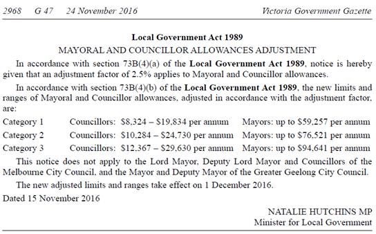
Councillor Allowance Categories
Councils are divided into three
categories based on the income and population of each Council.
The Minister for Local Government has
approved an adjustment factor increase of 2.5% to the below Mayoral and
Councillor allowances, effective 1 December 2016, under section 73B(4) of the
local Government Act 1989.
|
Category 1
|
Category 2
|
Category 3
|
|
Current
Range:
Councillors
$8,324-$19,834
Mayor
up to $59,257
|
Current
Range:
Councillors
$10,284-$24,730
Mayor
up to $76,521
|
Current
Range:
Councillors
$12,367-$29,630
Mayor
up to $94,641
|
|
Alpine
Shire Council
Ararat
Rural City Council
Benalla
Rural City Council
Borough
of Queenscliffe
Buloke Shire Council
Central Goldfields Shire Council
Gannawarra Shire Council
Golden Plains Shire Council
Hepburn Shire Council
Hindmarsh Shire Council
Horsham Rural City Council
Indigo Shire Council
Loddon Shire Council
Mansfield Shire Council
Mount Alexander Shire Council
|
Ballarat
City Council
Banyule
City Council
Bass
Coast Shire Council
Baw
Baw Shire Council
Bayside
City Council
Campaspe
Shire Council
Cardinia
Shire Council
Colac
Otway Shire Council
Corangamite
Shire Council
East
Gippsland Shire Council
Glenelg
Shire Council
Greater
Shepparton City Council
Hobsons
Bay City Council
Latrobe
City Council
Macedon
Ranges Shire Council
|
Boroondara
City Council
Brimbank
City Council
Casey
City Council
Darebin
City Council
Glen
Eira City Council
Frankston
City Council
Greater
Bendigo City Council
Greater
Dandenong City Council
Hume
City Council
Kingston
City Council
Knox
City Council
Melton
Shire Council
Monash
City Council
Moreland
City Council
Moonee
Valley City Council
|
|
Category 1
|
Category 2
|
Category 3
|
|
Murrindindi
Shire Council
Northern Grampians Shire Council
Pyrenees
Shire Council
Southern Grampians Shire Council
Strathbogie
Shire Council
Towong
Shire Council
West
Wimmera Shire Council
Yarriambiack
Shire Council
|
Manningham
City Council
Maribyrnong
City Council
Maroondah
City Council
Mildura
Rural City Council
Mitchell
Shire Council
Moira
Shire Council
Moorabool
Shire Council
Moyne
Shire Council
Nillumbik
Shire Council
South
Gippsland Shire Council
Surf
Coast Shire Council
Swan
Hill Rural City Council
Wangaratta
Rural City Council
Warrnambool
City Council
Wellington
Shire Council
Wodonga
City Council
Yarra
City Council
|
Mornington
Peninsula Shire Council
Port
Phillip City Council
Stonnington
City Council
Whitehorse
City Council
Whittlesea
City Council
Wyndham
City Council
Yarra
Ranges Shire Council
|
Attachment
1 Extract of Special Committee of
Council Minutes Inclusive of Public Submissions
Attendance
Cr Davenport left the Chamber at 9:19pm, returning at 9.21pm
⇨ 
Ordinary Council Minutes 20
March 2017
10 Reports
from Delegates, Special Committee Recommendations and Assembly of Councillors
Records
10.1 Reports
by Delegates
|
10.1.1
|
Cr Liu
reported on her attendance at the:
·
Whitehorse
Business Group Board meeting held on the 7 March 2017.
·
Whitehorse
Business Group 2017 Season Launch held on the 9 March 2017.
|
|
10.1.2
|
Cr Tescher
reported on her attendance at the Audit Advisory Committee meeting held on
the 20 March 2017.
|
|
10.1.3
|
Cr
Cutts reported on her attendance at the Visual Arts Committee meeting held on
the 22 February 2017.
|
|
10.1.4
|
Cr
Munroe reported on his attendance at Metropolitan Transport Forum held on the
1 March 2017.
|
|
10.1.5
|
Cr
Bennett reported on his attendance at the:
·
Whitehorse
Business Group Board meeting held on the 7 March 2017.
·
Eastern
Transport Coalition on the 16 March 2017 hosted by Whitehorse.
|
|
10.1.6
|
Cr
Carr reported on her attendance at the Visual Arts Committee meeting held on
the 22 February 2017
|
|
10.1.7
|
Cr
Ellis reported on her attendance at the:
·
Eastern Affordable
Housing Alliance meeting held on the 9 February 2017
·
CEDA -
Social and Affordable Housing - Where to from here, meeting on the 16 March
2017
·
Launch of
Keeping Community Stories Alive – Remarkable Women of Whitehorse and
Manningham held on the 8 March 2017
|
|
10.1.8
|
Cr
Massoud reported on her attendance at the:
·
Two MAV
Strategic Planning Meetings held on the 21 and 23 February 2017.
·
Audit Advisory
Committee meeting held on the 20 March 2017.
|
Ordinary Council Minutes 20
March 2017
10.2 Recommendations
from the Special Committee of Council Meeting of 14 March 2017
Nil
10.3 Record
of Assembly of Councillors
|
Meeting Date
|
Matter/s
Discussed
|
Councillors
Present
|
Officers Present
|
Disclosures of Conflict of Interest
|
Councillor
/Officer attendance following disclosure
|
|
15-02-17
6.30- 10.30pm
|
Councillor Budget Workshop
|
Cr Massoud (Mayor & Chair)
Cr Carr
Cr Cutts
Cr Davenport
Cr Ellis
Cr Liu
Cr Munroe
Cr Tescher
Cr Stennett
|
N
Duff
J
Green
P
Warner
T
Wilkinson P Smith
A
De Fazio
J
Gorst
D
Logan
|
Nil
|
Nil
|
|
20-02-17
6.30-7.00pm
|
Councillor Informal Briefing Session
· Notice of Motion 103
· Special Council Meeting –
Adjournment Procedure
· Council Plan – Proposed Briefing
Session
· Councillor Code of Conduct
|
Cr Massoud (Mayor & Chair)
Cr Bennett
Cr Carr
Cr Cutts
Cr Davenport
Cr Ellis
Cr Liu
Cr Munroe
Cr Tescher
Cr Stennett
|
N Duff
J Green
P Warner
P Smith
A De Fazio
P Moore
N Man
|
Cr Liu disclosed a conflicting personal
interest in Item 9.1.1 Amendment C194 to the Whitehorse Planning Scheme
– Combined Amendment & Planning Permit Application WH/2016/1196
for 517 & 519-521 Station Street & 2-8 Oxford Street, Box Hill
|
Cr Liu was not required
to leave the meeting as the Item was not discussed
|
|
06-03-17
6.30-8.45pm
|
Strategic Planning Session
· Audit Committee Update
· Whitehorse Municipal Public health & Wellbeing Plan Update
· Financial Report as at 31 January 2017
· Capital Works
· 2017/2018 Fees & Charges
· Morack Golf Course Strategic Plan
· Draft Built Form Guidelines – C175
|
Cr Massoud (Mayor & Chair)
Cr Bennett
Cr Carr
Cr Cutts
Cr Davenport
Cr Ellis
Cr Liu
Cr Munroe
Cr Tescher
Cr Stennett
(N.B Cr Stennett arrived at 6.45pm)
|
N
Duff
J
Green
P
Warner
T
Wilkinson P Smith
A
De Fazio
D
Seddon
B
Upston
D
Logan
J
Blythe
B Morrison
J Chambers
|
Nil
|
Nil
|
|
Meeting Date
|
Matter/s
Discussed
|
Councillors
Present
|
Officers Present
|
Disclosures of Conflict of Interest
|
Councillor
/Officer attendance following disclosure
|
|
07-03-17
6.30 – 9.45pm
|
Strategy Session – Whitehorse Centre Development
|
Cr Massoud (Mayor & Chair)
Cr Bennett
Cr Carr
Cr Cutts
Cr Davenport
Cr Liu
Cr Munroe
Cr Tescher
(N.B Cr Davenport left at 8.30pm)
|
N
Duff
J
Green
P
Warner
T
Wilkinson
P
Smith
A
De Fazio
B Morrison
S Price
|
Nil
|
Nil
|
|
14-03-17
6.30 –
9.00pm
|
Councillor Briefing Session
3.1 Councillor
Dashboard
· Special Committee Agenda/Other Business Items
· Draft Council Agenda 20 March 2017
|
Cr Massoud (Mayor & Chair)
Cr Bennett
Cr Carr
Cr Cutts
Cr Davenport
Cr Liu
Cr Munroe
Cr Tescher
|
N
Duff
J
Green
P
Warner
T
Wilkinson
P
Smith
A
De Fazio
S
Freud
J
Russell
K
Marriott
J
Hansen
A
Egan
L
Papageorgiou
|
|
|
Ordinary Council Minutes 20
March 2017
11 Reports
on Conferences/Seminars Attendance
11.1 Cr
Davenport reported on his attendance at the MAV Local Government Road Safety
Forum held on the 14 March 2017.
11.2 Cr
Carr sought the Mayor’s indulgence to report on her attendance at the:
· International Women’s Day
Morning tea held on the 8 March 2017 at the City of Whitehorse.
· Lions Club of Nunawading
International Women’s Day Dinner held on the 8 March 2017.
11.3 Cr Bennett reported on
his attendance at the MAV Community Engagement & Placemaking Skills seminar
held on the 8 March 2017.
11.4 Cr Munroe reported on
his attendance at the VLGA Leading the Agenda on Digital Transformation seminar
held on the 16 March 2017.
11.5 Cr Liu reported on her
attendance at the:
· International Women’s Day
2017 Breakfast held on the 8 March 2017 at Box Hill Rotary Club and Local
Suburbs.
· International Women’s Day
Morning Tea held on the 8 March 2017 at City of Whitehorse.
11.6 Cr
Cutts reported on her attendance at the MAV Land Use Planning – Building seminar
held on the 3 March 2017.
11.7 Cr
Massoud reported on her attendance at the:
· City of Whitehorse
International Women’s Day Morning Tea held on the 8 March 2017.
· Koonung Secondary
College on 17 March 2017 to welcome the visitors from City of Matsudo.
· MAV Local Government
Road Safety Forum held on the 14 March 2017.
12 Confidential
Reports
Nil
13 Close
Meeting
Meeting closed at 9.54pm
Confirmed this 18th day
of April 2017
_______________________________
CHAIRPERSON
Extract from the MAV Federal Budget submission
2017 - Budget Proposal: Commitment to
extend Australian Government funding for Universal Access to Early Childhood
Education.