Ordinary
Council Meeting
Held in the
Council Chamber
Whitehorse Civic Centre
379 Whitehorse Road Nunawading
on
Tuesday 18 April 2017
at 7.00pm
Members: Cr
Denise Massoud (Mayor), Cr Bill Bennett,
Cr Raylene Carr, Cr Prue Cutts, Cr Andrew Davenport,
Cr
Sharon Ellis, Cr Tina Liu, Cr Andrew Munroe,
Cr
Ben Stennett
Ms Noelene Duff
Chief Executive Officer
Ordinary Council Minutes 18
April 2017
Meeting opened at 7.00pm
Present: Cr Massoud (Mayor), Cr Bennett, Cr
Carr, Cr Cutts, Cr Davenport,
Cr
Ellis, Cr Liu, Cr Munroe, Cr Stennett
1 PRAYER
1a Prayer
for Council
We give thanks, O God, for the Men and Women of the past whose
generous devotion to the common good has been the making of our City.
Grant that our own generation may build worthily on the foundations
they have laid.
Direct our minds that all we plan and determine, is for the
wellbeing of our City.
Amen.
1b Aboriginal
Reconciliation Statement
“In the spirit of reconciliation Whitehorse City Council
acknowledges the Wurundjeri people as the traditional custodians of the land we
are meeting on. We pay our respects to their Elders past and present.”
2 WELCOME
AND APOLOGIES
The Mayor welcomed all
APOLOGIES: Nil
3 DISCLOSURE
OF CONFLICT OF INTERESTS
Cr Liu disclosed an indirect
conflict of interest in Item 12.1 Purchase of Council Land.
4 CONFIRMATION
OF MINUTES OF PREVIOUS MEETINGS
Minutes of the Ordinary Council Meeting 20 March
2017 and Special Council Meeting Whitehorse Centre 10 April 2017.
5 RESPONSES
TO QUESTIONS
None Submitted
6 Notices
of Motion
Nil
7 Petitions
Cr Munroe
tabled a petition signed by 190 signatories in opposition to the proposed development
plans for 229-231 Blackburn Road Blackburn South.
COUNCIL
RESOLUTION
Moved by Cr
Munroe, Seconded by Cr Davenport
That Council receive the petition for
consideration as part of Council’s deliberations on
Item 9.1.2 229-231 Blackburn Road Blackburn South (Lot 285 LP
510800) Construction of a three storey building for four offices and 17
dwellings, use of the land for a dwelling, reduction in the required car
parking provision and alteration of access to a road zone (Category 1).
CARRIED UNANIMOUSLY
8 Urgent
Business
Nil
Ordinary Council Minutes 18
April 2017
9 Council
Reports
9.1 City
Development
Statutory Planning
9.1.1 182-186
Burwood Highway, Burwood (Lot 2 TP 186129R) – Construction of seven
dwellings, comprising one three-storey and six four-storey dwellings, reduction
of standard car parking requirement (one visitor parking space) and alteration
of access to road in a Road Zone, Category 1
FILE NUMBER: WH/2016/1021
ATTACHMENT
SUMMARY
This application was advertised,
and one objection was received. The objection raised issues with neighbourhood
character, streetscape, overshadowing, and devaluation of property. This report
assesses the application against the relevant provisions of the Whitehorse
Planning Scheme, as well as the objector concerns. It is recommended that
the application be supported, subject to conditions. This application has been
called in by Councillor Ellis.
|
RECOMMENDATION
That Council:
A Being
the Responsible Authority, having caused Application WH/2016/1021 for 182-186
Burwood Highway, BURWOOD (LOT 1 TP 186129R, LOT 2 TP 186129R) to be
advertised and having received and noted the objections is of the opinion
that the granting of a Planning Permit for the Construction of seven
dwellings, comprising one three storey and six four storey dwellings,
reduction of standard car parking requirement (one visitor parking space) and
alteration of access to road in a road zone Category 1 is acceptable and
should not unreasonably impact the amenity of adjacent properties.
B Issue
a Notice of Decision to Grant a Permit under the Whitehorse Planning Scheme
to the land described as 182-186 Burwood Highway, BURWOOD (LOT 2 TP 186129R)
for the construction of seven dwellings, comprising one three storey and six
four storey dwellings, reduction of standard car parking requirement (one
visitor parking space) and alteration of access to road in a road zone,
subject to the following conditions:
1. Before
the development starts, or any trees or vegetation removed, amended plans
(three copies in A1 size and one copy reduced to A3 size) shall be submitted
to and approved by the Responsible Authority. The plans must be drawn to
1:100 scale, with dimensions, and be generally in accordance with the plans
submitted with the application but modified to show:
a) Dwelling
1 setback at least 2 metres, Dwellings 2 and 3 setback at least 2.6 metres,
and Dwelling 6 setback at least 3 metres from the western boundary at ground
floor level without reducing any other existing setbacks.
b) Provision
of a freestanding trellis 300mm high above the western boundary fence
adjacent to Dwellings 5, 6 and 7.
c) Provision
of double glazing to the habitable room windows of Dwelling 1.
d) Provision
of a canopy above the entry of each dwelling.
e) The
access crossover to be flared at 60 degrees with 3.0 metres radial turnouts
at the kerb and with 1.0 metre clearance from any fixed object at the
entrance of the property, as required by Condition 22 of this permit.
f) The
following reports to be submitted will form part of the endorsed
documentation:
i. Sustainable
Design Assessment in accordance with Condition 10 of this permit.
ii. Waste
Management Plan in accordance with Condition 13 of this permit.
g) Notation
on site plans indicating that all obscured glazing be manufactured obscured
glass. Obscure film being applied to clear glazing will not be accepted.
h) The
locations of Tree Protection Zones described in Condition 5, with all
nominated trees clearly identified and numbered on both site and landscape
plans, and the requirements of conditions 5 and 6 to be annotated on the
development and landscape plans.
i) Landscape
Plan in accordance with Condition 3, including the following:
i. One
of the following trees to be planted within the front setback of Dwelling 1:
· Cedrus
atlantica f. glauca – Blue Atlas Cedar.
· Cedrus
deodara – Himalayan Cedar.
ii. All
new trees must be planted at a minimum height of 1.5 metres.
All of the above must be
to the satisfaction of the Responsible Authority. Once approved these plans
become the endorsed plans of this permit.
2. The
layout of the site and the size, design and location of the buildings and
works permitted must always accord with the endorsed plan and must not be
altered or modified without the further written consent of the Responsible
Authority.
3. No
building or works must be commenced (and no trees or vegetation shall be
removed) until a landscape plan prepared by a suitably qualified and
experienced person or firm has been submitted to and endorsed by the
Responsible Authority. This plan when endorsed shall form part of this
permit. This plan shall show:
a) A
survey of all existing vegetation, abutting street trees, natural features
and vegetation.
b) Buildings,
outbuildings and trees in neighbouring lots that would affect the landscape
design.
c) Planting
within and around the perimeter of the site comprising trees and shrubs
capable of:
i. Providing
a complete garden scheme,
ii. Softening
the building bulk,
iii. Providing
some upper canopy for landscape perspective,
iv. Minimising
the potential of any overlooking between habitable rooms of adjacent
dwellings.
d) A
schedule of the botanical name of all trees and shrubs proposed to be
retained and those to be removed incorporating any relevant requirements of
condition No. 1.
e) The
proposed design features such as paths, paving, lawn and mulch.
f) A
planting schedule of all proposed vegetation (trees, shrubs and ground
covers) which includes, botanical names, common names, pot size, mature size
and total quantities of each plant.
Landscaping in
accordance with this approved plan and schedule shall be completed before the
addition to the building is occupied.
Once approved these
plans become the endorsed plans of this permit.
4. The
garden areas shown on the endorsed plan must only be used as gardens and must
be maintained in a proper, tidy and healthy condition to the satisfaction of
the Responsible Authority. Should any tree or shrub be removed or
destroyed it may be required to be replaced by a tree or shrub of similar
size and variety.
5. Prior
to commencement of any building or demolition works on the land, a Tree
Protection Zones (TPZs) must be established on the subject site (and nature
strip if required) and maintained during, and until completion of, all
buildings and works including landscaping, around the following trees in
accordance with the distances and measures specified below, to the
satisfaction of the Responsible Authority:
a) Tree
Protection Zone distances:
i. Tree
1 (Lophostemon confertus) – 2.4m metre radius from centre base of tree.
ii. Tree
4 (Grevillia robusta) – 3.2 metre radius from centre base of tree.
iii. Tree
5 (Eucalyptus saligna) – 5.4 metre radius from centre base of tree.
iv. Tree
9 (Eucalyptus camaldulensis) – 13.2 metre radius from centre base of
tree.
b) Tree
Protection Zone measures are to be established in accordance with Australian
Standard 4970-2009 and are to include the following:
i. Erection
of solid chain mesh or similar type fencing at a minimum height of 1.8 metres
in height held in place with concrete feet.
ii. Signage
placed around the outer edge of perimeter the fencing identifying the area as
a TPZ. The signage should be visible from within the development, with the
lettering complying with AS 1319.
iii. Mulch
across the surface of the TPZ to a depth of 100mm and undertake supplementary
provide watering/irrigation within the TPZ, prior and during any works
performed.
iv. No
excavation, constructions works or activities, grade changes, surface
treatments or storage of materials of any kind are permitted within the TPZ
unless otherwise approved within this permit or further approved in writing
by the Responsible Authority.
v. All
supports and bracing should be outside the TPZ and any excavation for
supports or bracing should avoid damaging roots where possible.
vi. No
trenching is allowed within the TPZ for the installation of utility services
unless tree sensitive installation methods such as boring have been approved
by the Responsible Authority.
vii. Where
construction is approved within the TPZ, fencing and mulching should be
placed at the outer point of the construction area.
viii. Where
there are approved works within the TPZ, it may only be reduced to the
required amount by an authorized person only during approved construction
within the TPZ, and must be restored in accordance with the above
requirements at all other times.
6. During
construction of any buildings, or during other works, the following tree
protection requirements are to be adhered to, to the satisfaction of the
Responsible Authority:
a) All
buildings and works for the demolition of the site and construction of the
development (as shown on the endorsed plans) must not alter the existing
ground level or topography of the land within 2.0m of the southwest boundary
fence and 2.6m of the southeast boundary fence where the TPZ of Tree 9.
b) All
buildings and works (soft landscaping allowable), including soil level
changes, must be setback 2.0m from the southwest boundary fence and 2.6m of
the southeast boundary fence where within the TPZ of Tree 9.
7. The
existing street tree shall not be removed or damaged except with the written
consent of the Responsible Authority.
8. The
development must be provided with external lighting capable of illuminating
access to each garage and car parking space. Lighting must be located,
directed and shielded and of limited intensity that no nuisance or loss of
amenity is caused to any person within and beyond the site.
9. All
treatments to prevent overlooking must not include ‘Translucent
film’ on windows and must be in accordance with Standard B22 of Clause
55.
Environmentally
Sustainable Design
10. Prior
to the commencement of any buildings and works, an amended Sustainable Design
Assessment must be submitted and endorsed to the satisfaction of the
Responsible Authority. The amended assessment must demonstrate that the
proposal passes the IEQ Category requirement on the BESS Report.
The requirements of the
Sustainable Design Assessment must be demonstrated on the plans and
elevations submitted for endorsement, and the requirements of this plan must
be implemented by the building manager, owners and occupiers of the site when
constructing and fitting out the residential building, and for the duration
of the building’s operation in accordance with this permit, to the
satisfaction of the Responsible Authority.
Once submitted and
approved to the satisfaction of the Responsible Authority, the Sustainable
Design Assessment will form part of the endorsed plans of this permit.
11. Prior
to the occupation of any dwelling approved under this permit, a report from
the author of the Sustainable Design Assessment, approved pursuant to this
permit, or similarly qualified person or company, must be submitted to the
Responsible Authority. The report must be to the satisfaction of the
Responsible Authority and must confirm that all measures specified in the
Sustainable Design Assessment have been implemented in accordance with the
approved plan.
12. All
works must be undertaken in accordance with the endorsed Sustainable Design
Assessment to the satisfaction of the Responsible Authority, and the approved
uses and building must operate in accordance with this Plan, to the
satisfaction of the Responsible Authority. No alterations to the Sustainable
Design Assessment may occur without the prior written consent of the
Responsible Authority.
Waste Management Plan
13. Prior
to the commencement of buildings and works, a Waste Management Plan prepared
by a suitably qualified consultant, including the changes listed below for
endorsement must be submitted to the satisfaction of the Responsible
Authority.
The requirements and
outcomes of the Waste Management Plan must be demonstrated on the plans and
elevations submitted for endorsement.
Once submitted to and
approved by the Responsible Authority, the Waste Management Plan must form
part of the documents endorsed as part of this planning permit.
The requirements of the
Waste Management Plan must be implemented by the building manager, owners and
occupiers of the site for the duration of the building’s operation in
accordance with this permit, to the satisfaction of the Responsible
Authority.
Construction
Management Plan
14. Prior
to the commencement of buildings or works on the land, a Construction
Management Plan, detailing how the owner will manage the environmental and
construction issues associated with the development, must be submitted to and
approved by Council.
This plan is to be to
the satisfaction of the Responsible Authority and must be prepared in
accordance with the City of Whitehorse Construction Management Plan
Guidelines.
Once submitted to and
approved by the Responsible Authority the Construction Management Plan will
form part of the documents endorsed as part of this planning permit.
When approved the
Construction Management Plan will form part of this permit and must be
complied with, to the satisfaction of the Responsible Authority, to the
extent that this is in the control of the owner of the land.
The owner of the land is
to be responsible for all costs associated with the works to be undertaken in
accordance with the requirements of the Construction Management Plan.
Assets and Drainage
15. All
stormwater drains must be connected to a point of discharge to the
satisfaction of Responsible Authority.
16. Detailed
plans and computations for stormwater on-site detention (if required) and
connection to the legal point of discharge must be prepared by a consulting
engineer and submitted for approval to the Responsible Authority prior to the
commencement of any works.
17. Stormwater
connection to the nominated point of discharge and stormwater on-site
detention (if required) must be completed and approved to the satisfaction of
the Responsible Authority prior to the occupation of the buildings.
18. Stormwater
that could adversely affect any adjacent land shall not be discharged from
the subject site onto the surface of the adjacent land.
19. The
Applicant/Owner shall be responsible to meet all costs associated with
reinstatement and/or alterations to Council or other Public Authority assets
deemed necessary by such Authorities as a result of the development.
The Applicant/Owner shall be responsible to obtain an "Asset Protection
Permit" from Council at least 7 days prior to the commencement of any
works on the land and obtain prior specific written approval for any works
involving the alteration of Council or other Public Authority
assets.’’
VicRoads Conditions
20. All
vehicles must enter and exit the land in a forward direction.
21. Any
obstruction or vegetation must be kept low to achieve the driver sightline
distance at the access, as per Design Standard 1 of Clause 52.06 of the
Planning Scheme and AS/NZS 2890.1:2004.
22. The
access crossover should be flared at 60 degrees with 3.0m radial turnouts at
the kerb and with 1.0m clearance from any fixed object at the entrance of the
property.
Expiry
23. This
permit will expire if one of the following circumstances applies:
a) The
development is not commenced within two (2) years from the date of issue of
this permit;
b) The
development is not completed within four (4) years from the date of this
permit.
The Responsible
Authority may extend the periods referred to if a request is made in writing
pursuant to the provisions of Section 69 of the Planning and Environment Act
1987.
Permit Notes:
Assets and Drainage
A. Relevant
Authority during the construction stages of the development. Site
controls and erosion minimisation techniques are to be in accordance with the
EPA (Environment Protection Authority) Victoria “Environmental
Guidelines for Major Construction Sites”. The works during and after
construction must comply with the above guidelines and in potentially high
erosion areas a detailed plan may be required to indicate proposed measures
and methodology.
B. The
property owner/ builder is to obtain the relevant permits and consents from
Council in relation to asset protection, drainage works in easements and
works in the road reserve prior to the commencement of any works.
C. All
stormwater drainage within the development site and associated with the
building(s) (except for an on-site detention system and connection to the
nominated legal point of discharge within the site) must be approved and
completed to the satisfaction of the Building Surveyor prior to the occupation
of the building(s), in accordance with the provisions of the Building
Regulations (2006) section 610.
D. The
surface treatment and design of all crossovers and driveways shall be of
materials submitted to and approved by the Responsible Authority and must be
constructed in accordance with the submitted details.
E. No
alteration to existing interface levels will be permitted other than to
maintain or introduce adequate and consistent road reserve crossfall and
longitudinal fall all to the satisfaction of the Responsible Authority.
F. Access
to the development must be resolved within the development site. No
provision for access and/or Disability Discrimination Act (DDA) compliance
will be permitted external to the site being within any adjacent road
reserve, right of way, reservation or other land owned managed by the
Responsible Authority as may be applicable.
G. Any
proposed vehicle crossing must adhere to Whitehorse Council’s –
Vehicle Crossing General Specifications.
H. Any
services that need to be removed and relocated due to the location of the
proposed vehicular crossing must be financed by the developer.
I. Any
services that need to be removed and relocated due to the location of the
proposed vehicular crossing must be approved by the Responsible Authority
prior to endorsement of the plans.
Street Tree
J. Any
trees that need to be removed due to the location of the proposed vehicle
crossing must be approved by Parkswide prior to endorsement of the plans.
K. Report
and consent – building over the easement must be approved prior to
endorsement of the building permit.
L. No
trees are permitted to be planted within the easement.
C Has
made this decision having particular regard to the requirements of Sections
58, 59, 60 and 61 of the Planning and Environment Act 1987.
|
|
COUNCIL RESOLUTION
Moved by Cr Ellis, Seconded by Cr Davenport
That Council:
A.
Being the Responsible Authority, having caused Application
WH/2016/1021 for 182-186 Burwood Highway, BURWOOD (LOT 1 TP 186129R, LOT 2 TP
186129R) to be advertised and having received and noted the objections is of
the opinion that the granting of a Planning Permit for the Construction of
seven dwellings, comprising one three storey and six four storey dwellings,
reduction of standard car parking requirement (one visitor parking space) and
alteration of access to road in a road zone Category 1 is acceptable and
should not unreasonably impact the amenity of adjacent properties.
B. Issue a
Notice of Decision to Grant a Permit under the Whitehorse Planning Scheme to
the land described as 182-186 Burwood Highway, BURWOOD (LOT 2 TP 186129R) for
the construction of seven dwellings, comprising one three storey and six four
storey dwellings and alteration of access to road in a Road Zone, Category 1,
subject to the following conditions:
1. Before
the development starts, or any trees or vegetation removed, amended plans
(three copies in A1 size and one copy reduced to A3 size) shall be submitted
to and approved by the Responsible Authority. The plans must be drawn to 1:100
scale, with dimensions, and be generally in accordance with the plans
submitted with the application but modified to show:
a) Provision
of a minimum of one (1) visitor car parking space on site.
b) Dwelling
1 setback at least 2 metres, Dwellings 2 and 3 setback at least 2.6 metres,
and Dwelling 6 setback at least 3 metres from the western boundary at ground
floor level without reducing any other existing setbacks.
c) Provision
of a freestanding trellis 300mm high above the western boundary fence
adjacent to Dwellings 5, 6 and 7.
d) Provision
of double glazing to the habitable room windows of Dwelling 1.
e) Provision
of a canopy above the entry of each dwelling.
f) The
access crossover to be flared at 60 degrees with 3.0 metres radial turnouts
at the kerb and with 1.0 metre clearance from any fixed object at the
entrance of the property, as required by Condition 22 of this permit.
g) The
following reports to be submitted will form part of the endorsed
documentation:
i.
Sustainable Design Assessment in accordance with Condition 10 of this
permit.
ii.
Waste Management Plan in accordance with Condition 13 of this permit.
h) Notation
on site plans indicating that all obscured glazing be manufactured obscured
glass. Obscure film being applied to clear glazing will not be accepted.
i) The
locations of Tree Protection Zones described in Condition 5, with all
nominated trees clearly identified and numbered on both site and landscape
plans, and the requirements of conditions 5 and 6 to be annotated on the
development and landscape plans.
j) Landscape
Plan in accordance with Condition 3, including the following:
i.
One of the following trees to be planted within the front setback of
Dwelling 1:
· Cedrus
atlantica f. glauca – Blue Atlas Cedar.
· Cedrus
deodara – Himalayan Cedar.
ii.
All new trees must be planted at a minimum height of 1.5 metres.
All of the above must be
to the satisfaction of the Responsible Authority. Once approved these plans
become the endorsed plans of this permit.
2. The
layout of the site and the size, design and location of the buildings and
works permitted must always accord with the endorsed plan and must not be
altered or modified without the further written consent of the Responsible
Authority.
3. No
building or works must be commenced (and no trees or vegetation shall be
removed) until a landscape plan prepared by a suitably qualified and
experienced person or firm has been submitted to and endorsed by the
Responsible Authority. This plan when endorsed shall form part of this
permit. This plan shall show:
a) A
survey of all existing vegetation, abutting street trees, natural features
and vegetation.
b) Buildings,
outbuildings and trees in neighbouring lots that would affect the landscape
design.
c) Planting
within and around the perimeter of the site comprising trees and shrubs
capable of:
i. Providing
a complete garden scheme,
ii. Softening
the building bulk,
iii. Providing
some upper canopy for landscape perspective,
iv. Minimising
the potential of any overlooking between habitable rooms of adjacent
dwellings.
d) A
schedule of the botanical name of all trees and shrubs proposed to be
retained and those to be removed incorporating any relevant requirements of
condition No. 1.
e) The
proposed design features such as paths, paving, lawn and mulch.
f) A
planting schedule of all proposed vegetation (trees, shrubs and ground
covers) which includes, botanical names, common names, pot size, mature size
and total quantities of each plant.
Landscaping in
accordance with this approved plan and schedule shall be completed before the
addition to the building is occupied.
Once approved these
plans become the endorsed plans of this permit.
4. The
garden areas shown on the endorsed plan must only be used as gardens and must
be maintained in a proper, tidy and healthy condition to the satisfaction of
the Responsible Authority. Should any tree or shrub be removed or
destroyed it may be required to be replaced by a tree or shrub of similar
size and variety.
5. Prior
to commencement of any building or demolition works on the land, a Tree
Protection Zones (TPZs) must be established on the subject site (and nature
strip if required) and maintained during, and until completion of, all
buildings and works including landscaping, around the following trees in
accordance with the distances and measures specified below, to the
satisfaction of the Responsible Authority:
a) Tree
Protection Zone distances:
i.
Tree 1 (Lophostemon confertus) – 2.4m metre radius
from centre base of tree.
ii.
Tree 4 (Grevillia robusta) – 3.2 metre radius from
centre base of tree.
iii.
Tree 5 (Eucalyptus saligna) – 5.4 metre radius from
centre base of tree.
iv.
Tree 9 (Eucalyptus camaldulensis) – 13.2 metre
radius from centre base of tree.
b) Tree
Protection Zone measures are to be established in accordance with Australian
Standard 4970-2009 and are to include the following:
i.
Erection of solid chain mesh or similar type fencing at
a minimum height of 1.8 metres in height held in place with concrete feet.
ii.
Signage placed around the outer edge of perimeter the
fencing identifying the area as a TPZ. The signage should be visible from
within the development, with the lettering complying with AS 1319.
iii.
Mulch across the surface of the TPZ to a depth of 100mm
and undertake supplementary provide watering/irrigation within the TPZ, prior
and during any works performed.
iv.
No excavation, constructions works or activities, grade
changes, surface treatments or storage of materials of any kind are permitted
within the TPZ unless otherwise approved within this permit or further
approved in writing by the Responsible Authority.
v.
All supports and bracing should be outside the TPZ and
any excavation for supports or bracing should avoid damaging roots where
possible.
vi.
No trenching is allowed within the TPZ for the
installation of utility services unless tree sensitive installation methods
such as boring have been approved by the Responsible Authority.
vii.
Where construction is approved within the TPZ, fencing
and mulching should be placed at the outer point of the construction area.
viii.
Where there are approved works within the TPZ, it may
only be reduced to the required amount by an authorized person only during
approved construction within the TPZ, and must be restored in accordance with
the above requirements at all other times.
6. During
construction of any buildings, or during other works, the following tree
protection requirements are to be adhered to, to the satisfaction of the
Responsible Authority:
a) All
buildings and works for the demolition of the site and construction of the
development (as shown on the endorsed plans) must not alter the existing
ground level or topography of the land within 2.0m of the southwest boundary
fence and 2.6m of the southeast boundary fence where the TPZ of Tree 9.
b) All
buildings and works (soft landscaping allowable), including soil level
changes, must be setback 2.0m from the southwest boundary fence and 2.6m of
the southeast boundary fence where within the TPZ of Tree 9.
7. The
existing street tree shall not be removed or damaged except with the written
consent of the Responsible Authority.
8. The
development must be provided with external lighting capable of illuminating
access to each garage and car parking space. Lighting must be located,
directed and shielded and of limited intensity that no nuisance or loss of
amenity is caused to any person within and beyond the site.
9. All
treatments to prevent overlooking must not include ‘Translucent
film’ on windows and must be in accordance with Standard B22 of Clause
55.
Environmentally
Sustainable Design
10. Prior
to the commencement of any buildings and works, an amended Sustainable Design
Assessment must be submitted and endorsed to the satisfaction of the
Responsible Authority. The amended assessment must demonstrate that the
proposal passes the IEQ Category requirement on the BESS Report.
The requirements of the
Sustainable Design Assessment must be demonstrated on the plans and
elevations submitted for endorsement, and the requirements of this plan must
be implemented by the building manager, owners and occupiers of the site when
constructing and fitting out the residential building, and for the duration
of the building’s operation in accordance with this permit, to the
satisfaction of the Responsible Authority.
Once submitted and
approved to the satisfaction of the Responsible Authority, the Sustainable
Design Assessment will form part of the endorsed plans of this permit.
11. Prior
to the occupation of any dwelling approved under this permit, a report from
the author of the Sustainable Design Assessment, approved pursuant to this
permit, or similarly qualified person or company, must be submitted to the
Responsible Authority. The report must be to the satisfaction of the
Responsible Authority and must confirm that all measures specified in the
Sustainable Design Assessment have been implemented in accordance with the
approved plan.
12. All
works must be undertaken in accordance with the endorsed Sustainable Design
Assessment to the satisfaction of the Responsible Authority, and the approved
uses and building must operate in accordance with this Plan, to the
satisfaction of the Responsible Authority. No alterations to the Sustainable
Design Assessment may occur without the prior written consent of the
Responsible Authority.
Waste Management Plan
13. Prior
to the commencement of buildings and works, a Waste Management Plan prepared
by a suitably qualified consultant, including the changes listed below for
endorsement must be submitted to the satisfaction of the Responsible
Authority.
The requirements and
outcomes of the Waste Management Plan must be demonstrated on the plans and
elevations submitted for endorsement.
Once submitted to and
approved by the Responsible Authority, the Waste Management Plan must form
part of the documents endorsed as part of this planning permit.
The requirements of the
Waste Management Plan must be implemented by the building manager, owners and
occupiers of the site for the duration of the building’s operation in
accordance with this permit, to the satisfaction of the Responsible
Authority.
Construction
Management Plan
14. Prior
to the commencement of buildings or works on the land, a Construction
Management Plan, detailing how the owner will manage the environmental and
construction issues associated with the development, must be submitted to and
approved by Council.
This plan is to be to
the satisfaction of the Responsible Authority and must be prepared in
accordance with the City of Whitehorse Construction Management Plan
Guidelines.
Once submitted to and
approved by the Responsible Authority the Construction Management Plan will
form part of the documents endorsed as part of this planning permit.
When approved the
Construction Management Plan will form part of this permit and must be
complied with, to the satisfaction of the Responsible Authority, to the
extent that this is in the control of the owner of the land.
The owner of the land is to
be responsible for all costs associated with the works to be undertaken in
accordance with the requirements of the Construction Management Plan.
Assets and Drainage
15. All
stormwater drains must be connected to a point of discharge to the
satisfaction of Responsible Authority.
16. Detailed
plans and computations for stormwater on-site detention (if required) and
connection to the legal point of discharge must be prepared by a consulting
engineer and submitted for approval to the Responsible Authority prior to the
commencement of any works.
17. Stormwater
connection to the nominated point of discharge and stormwater on-site
detention (if required) must be completed and approved to the satisfaction of
the Responsible Authority prior to the occupation of the buildings.
18. Stormwater
that could adversely affect any adjacent land shall not be discharged from
the subject site onto the surface of the adjacent land.
19. The
Applicant/Owner shall be responsible to meet all costs associated with
reinstatement and/or alterations to Council or other Public Authority assets
deemed necessary by such Authorities as a result of the development.
The Applicant/Owner shall be responsible to obtain an "Asset Protection
Permit" from Council at least 7 days prior to the commencement of any works
on the land and obtain prior specific written approval for any works
involving the alteration of Council or other Public Authority
assets.’’
VicRoads Conditions
20. All
vehicles must enter and exit the land in a forward direction.
21. Any
obstruction or vegetation must be kept low to achieve the driver sightline
distance at the access, as per Design Standard 1 of Clause 52.06 of the
Planning Scheme and AS/NZS 2890.1:2004.
22. The
access crossover should be flared at 60 degrees with 3.0m radial turnouts at
the kerb and with 1.0m clearance from any fixed object at the entrance of the
property.
Expiry
23. This
permit will expire if one of the following circumstances applies:
a)
The
development is not commenced within two (2) years from the date of issue of
this permit;
b)
The
development is not completed within four (4) years from the date of this
permit.
The Responsible
Authority may extend the periods referred to if a request is made in writing
pursuant to the provisions of Section 69 of the Planning and Environment Act
1987.
Permit Notes:
Assets and Drainage
A. Relevant
Authority during the construction stages of the development. Site
controls and erosion minimisation techniques are to be in accordance with the
EPA (Environment Protection Authority) Victoria “Environmental
Guidelines for Major Construction Sites”. The works during and after
construction must comply with the above guidelines and in potentially high
erosion areas a detailed plan may be required to indicate proposed measures
and methodology.
B. The
property owner/ builder is to obtain the relevant permits and consents from
Council in relation to asset protection, drainage works in easements and
works in the road reserve prior to the commencement of any works.
C. All
stormwater drainage within the development site and associated with the
building(s) (except for an on-site detention system and connection to the
nominated legal point of discharge within the site) must be approved and
completed to the satisfaction of the Building Surveyor prior to the
occupation of the building(s), in accordance with the provisions of the
Building Regulations (2006) section 610.
D. The
surface treatment and design of all crossovers and driveways shall be of
materials submitted to and approved by the Responsible Authority and must be
constructed in accordance with the submitted details.
E. No
alteration to existing interface levels will be permitted other than to
maintain or introduce adequate and consistent road reserve crossfall and
longitudinal fall all to the satisfaction of the Responsible Authority.
F. Access
to the development must be resolved within the development site. No
provision for access and/or Disability Discrimination Act (DDA) compliance
will be permitted external to the site being within any adjacent road
reserve, right of way, reservation or other land owned managed by the
Responsible Authority as may be applicable.
G. Any
proposed vehicle crossing must adhere to Whitehorse Council’s –
Vehicle Crossing General Specifications.
H. Any
services that need to be removed and relocated due to the location of the
proposed vehicular crossing must be financed by the developer.
I. Any
services that need to be removed and relocated due to the location of the
proposed vehicular crossing must be approved by the Responsible Authority
prior to endorsement of the plans.
Street Tree
J. Any
trees that need to be removed due to the location of the proposed vehicle
crossing must be approved by Parkswide prior to endorsement of the plans.
K. Report
and consent – building over the easement must be approved prior to endorsement
of the building permit.
L. No
trees are permitted to be planted within the easement.
C. All of
the above must be to the satisfaction of the Responsible Authority. Once
approved these plans become the endorsed plans of this permit.
CARRIED UNANIMOUSLY
|
MELWAYS REFERENCE 61 A6
|
Applicant: Townplus
Pty Ltd
Zoning: RGZ2
(Residential Growth Zone Schedule 2)
Overlays: Nil
Relevant Clauses:
Clause 11 Settlement
Clause 12 Environment
and Landscape Values
Clause 15 Built
Environment and Heritage
Clause 21.05 Environment
Clause 21.06 Housing
Clause 22.03 Residential
Development
Clause 22.04 Tree
Conservation
Clause 32.07 Residential
Growth Zone
Clause 52.06 Car
Parking
Clause 55 Two
or More Dwellings on a Lot or Residential Buildings
Clause 65 Decision
Guidelines
Ward: Riversdale
|
|
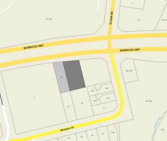
|
|
Subject
site
|
|
One (1)
Objector Property
|
é
North
|
BACKGROUND
History
Planning permit WH/2016/475 was
issued on 12 December 2016, for two (2) lot subdivision. The permit created two
lots, Lot 1 that contains the Burwood Telstra Exchange and Lot 2 which is a
vacant allotment (subject site).
This application was called in to
Council by Cr Ellis on 9 March 2017.
The Site and Surrounds
The subject site is located on the
south side of Burwood Highway in Burwood, approximately 45 metres west of the
intersection with McIntyre Street. The site has a frontage of 21.07
metres to Burwood Highway, a maximum depth of 46.32 metres, and a total site
area of 672m2. The site has a slope of approximately 2.5 metres from
west to east across the site. A 6.11 metre wide by 9.04 metre long
carriageway easement is located at the north-east corner of the site. The site
is currently vacant. It was previously used as a carpark by the adjoining
Telstra Exchange to the east. The Telstra exchange will still have access
to a total of six car parking spaces, two off McIntyre Street and four off
Burwood Highway accessed via the carriageway easement within the frontage of
the subject site. The subject site does not contain any significant vegetation.
The surrounding properties comprise
a mix of uses, including residential dwellings to the south and west, Telstra
Exchange building to the east, and the Presbyterian Ladies College opposite the
site, on the north side of Burwood Highway. There are a number of medium
density developments in the area. A number of canopy trees are located on the
adjoining property to the east and west adjacent to the subject site.
Planning Controls
In accordance with Clause 32.07 -
(Residential Growth Zone) of the Whitehorse Planning Scheme, a Planning Permit
is required for the construction of two or more dwellings on a lot.
A Planning Permit is also required
under Clause 52.06 (Car parking) for the reduction of standard car parking
requirement (one visitor parking space), and for alteration of access to a road
in a Road Zone Category 1 under Clause 52.29.
PROPOSAL
It is proposed to construct seven
dwellings, comprising one three-storey and six four-storey dwellings, reduction
of standard car parking requirement (one visitor parking space) and alteration
of access to road in a Road Zone, Category 1.
Each dwelling would contain two
bedrooms and a single garage, except for Dwelling 1 which will contain 3
bedrooms and a double garage. Vehicle access to and from the site would
be via a driveway along the eastern boundary and an existing crossover on
Burwood Highway.
The proposed development would be
setback 5.95m from the north (front) boundary, a minimum of 1.7m from the west
(side) boundary, 1.2m from the east (side) boundary, and 2.3m from the south
(rear) boundary. It would have a maximum height of 14.5m above natural
ground level.
The proposed development would have
a flat roof. Building materials include face brick, aluminium cladding,
and compressed fibre cement sheeting with concrete sealer for external walls.
CONSULTATION
Public Notice
The application was advertised by
mail to the adjacent property owners and occupiers and by erecting a notice on
front of the site. Following the advertising period, one (1) objection was
received. The issues raised in this objection largely relate to
neighbourhood character, streetscape, overshadowing and devaluation of
property.
Referrals
External
VicRoads
The proposal has been referred to
VicRoads under Section 55 of the Planning and Environment Act. VicRoads
has reviewed the application and has no objection to the proposal, subject to
conditions to be placed on the permit.
Internal
Planning Arborist
The proposal has been reviewed by
Council’s Planning Arborist, who raised no concern to the proposal, and
recommended a columnar exotic tree to be planted within the front setback, and
tree protection measures to be included for the neighbouring trees on any
permit issued.
Asset Engineering (Drainage)
The proposed plans have been
reviewed by Council’s Asset Engineer, who supports the proposal subject
to standard drainage and assets conditions.
Transport Engineering
The proposed plans have been
reviewed by Council’s Transport Engineer who supports the proposal and
commented that the single visitor parking space can be accommodated within the
available parking in surrounding streets.
DISCUSSION
The construction of seven dwellings
on this site is consistent with State and Local Planning Policies which
encourages higher density development within walking distance of shops,
recreation facilities and public transport. The proposal accords with
State Planning Policies which seek to ensure housing stock matches changing
demand by widening housing choice; encourages the development of well-designed
medium-density housing that makes better use of existing infrastructure; and
that new development respects the neighbourhood character and appropriately
responds to its landscape, valued built form and cultural context.
This proposed development is in
keeping with the built form and scale of the developments along Burwood
Highway, and the proposed design and siting is consistent, subject to
conditions, with the objectives and intent of Council’s Residential
Development Policy for developments within Substantial Change and Garden
Suburban areas, and Neighbourhood Character Area 1.
The proposed
development has been fully assessed against and is considered, subject to
conditions, to satisfy the relevant standards and objectives of Clause 55 (Two
or more dwellings on a lot) of the Whitehorse Planning Scheme.
The following
discussion covers the key issues raised during the application process.
Visitor
parking reduction
The application
is seeking a reduction of one (1) visitor car parking space on site. It is
noted that the subject site is well serviced by public transport, including
tram service along Burwood Highway, and bus services along both Burwood Highway
and Elgar Road.
Furthermore,
the submitted Parking and Traffic Assessment indicated that there were a
minimum of 24 car parking spaces available within reasonable walking distance,
that is 400 metres, from the subject site when the survey was undertaken on
Thursday 13 October 2016 at 9am, 12noon and 5pm and Saturday 15 October 2016 at
9am and 12noon.
It is therefore
considered that the reduction of one (1) visitor parking space can be easily
accommodated within the area. Moreover, the reduction has been assessed by and
supported by Council’s Transport Engineer.
Neighbourhood
character
The subject site is located in Area
No. 1 of the Whitehorse Neighbourhood Character Study. The preferred
character statement indicates that the substantial change area within and near
Burwood Village, and areas with good access to trams will accommodate new
medium density dwellings with more compact siting, while retaining space for
landscaping including trees. It is considered that the proposal is
consistent with the preferred character of the area. The proposal provides
sufficient space within the front setback for the planting of a canopy
tree. A condition will be placed on the permit to increase the setback to
the western boundary to allow additional landscaping long the side boundary to
maintain the landscape character of the area and rhythm of spacing between
dwellings. It is also noted that this is the key interface with the single
objector property, and as such increased setback distance and landscaping will
provide additional visual screening between the 2 properties.
Street setback
The Telstra exchange building on
the east adjoining property has a front setback of approximately 4.5m to
Burwood Highway, and the dwelling located on the west adjoining property has a
front setback of 11.36m to Burwood Highway. According to Standard B6, the
proposed development is required to be setback 7.9m from Burwood Highway.
The proposed development would have
a front setback ranging from 5.95m to 8.8m. Whilst the proposed front
setback partially fails to meet Standard B6, it is considered acceptable as the
subject site is located near the intersection of Elgar Road and Burwood Highway
where the front setbacks of the buildings nearby vary significantly. The
proposed front setback will make efficient use of the site and provides
sufficient landscaping opportunity for the planting of a canopy tree. It
should be noted that the development would have a minimum setback of 8.68m at
second floor level.
Given the above, it is considered
the proposed front setback is acceptable and meets the objective and decision
guidelines of clause 55.03-1 of the Whitehorse Planning Scheme.
Building height
The maximum building height
requirement at Clause 32.07-7 (Residential Growth Zone) replaces the maximum
building height specified in Standard B7 at Clause 55.
The Residential Growth Zone allows
a dwelling / residential building to have a maximum height of 14.5m if the
slope of the natural ground level is 2.5 degrees or more.
The proposed development will have
a maximum height of 14.5m which complies with the above requirement. The
subject site has a slope of approximately 3 degrees.
Energy efficiency
The proposal comprises a total of
seven dwellings. A Built Environment Sustainability Scorecard (BESS) Report
and Storm Report have been submitted, however, the proposal fails the Indoor Environment
Quality (IEQ) Category on the BESS Report, therefore, it will be a permit
condition requiring this category to be passed. That said, officers acknowledge
that the proposal can achieve compliance with these standards, therefore it is
a reasonable requirement for this to be demonstrated through conditions.
Safety
Entries of Dwellings 4 and 5 will
be obscured by Dwelling 3, and the entry of Dwelling 7 will be obscured by
Dwelling 6. As such, it is considered appropriate to require Dwelling 1
to setback 300mm further from the western boundary, Dwellings 2 and 3 to
setback 600mm further from the western boundary and Dwelling 6 setback 1m
further from the western boundary to increase visibility and improve
surveillance of dwelling entries from the street and common pathway. Setbacks
elsewhere within the development are not to be reduced to enable these western
setbacks to be achieved, as this would bring the building closer to the eastern
boundary and compromise the driveway width.
It is noted that the applicant has
agreed to the above changes.
Landscaping
The proposal provides adequate area
within the front setback for the planting of a canopy tree. The landscape
character of the area will be maintained.
It is noted that Council’s
Arborist has reviewed the application and has no objection to the removal of
Trees 2 and 3 and has recommended the planting of one of the following trees
within the front setback of the development:
· Cedrus
atlantica f. Glauca – Blue Atlas Cedar.
· Cedrus
deodara – Himalayan Cedar.
In addition, tree protection
measures will be required to be included on the permit for the neighbouring
trees (Trees 4, 5 and 9).
Tree protection measures will also
be required for the street tree (Tree 1) to ensure this tree is protected
during demolition and construction.
As previously mentioned, Dwellings
1, 2 ,3, and 6 will be setback further from the western boundary which will
increase landscaping opportunity along this boundary. A landscape plan
will be required as a condition of approval.
Overlooking
A condition will be placed on the
permit to require a freestanding 300mm high trellis to be provided above the
western boundary fence adjacent to Dwellings 5, 6 and 7 to limit overlooking
into the secluded private open space of the neighbouring property.
No overlooking will occur from
other habitable room windows.
Noise
impacts
It is
considered adequate to require the provision of double glazing to the habitable
room windows of Dwelling 1 to protect future residents from traffic noise from
Burwood Highway, consistent with the requirement of Standard B24. This
will be placed on the permit as a condition of approval.
Dwelling
entry
Standard B26
requires entries to dwellings be visible and easily identifiable from the
street and provided with shelter, a sense of personal address and a
transitional space around the entry.
It is therefore
considered appropriate to place a condition on the permit to require the
provision of a canopy at the entry of each dwelling.
Objectors Concerns not
Previously Addressed
Overshadowing
The shadows
diagrams submitted by the applicant indicate that shadows cast by the
development will be largely contained within the development site itself, or
are cast onto adjoining existing boundary fencing and sheds. The expected
shadowing is within the requirement of the relevant ResCode objective.
Devaluation of property.
The Victorian
Civil and Administrative Tribunal and its predecessors have generally found
subjective claims that a proposal will reduce property values are difficult, if
not impossible to gauge and of no assistance to the determination of a planning
permit application. It is considered the impacts of a proposal are best
assessed through an assessment of the amenity implications rather than any
impacts upon property values. This report provides a detailed assessment
of the amenity impact of the proposal.
CONCLUSION
The proposed development is
consistent with the relevant planning controls and policies, including the
State and Local Planning Policies and provisions of the Residential Growth
Zone. The proposed development form, siting and overall design is considered to
be acceptable and will integrate well with the existing and preferred built
form and character. The application has been advertised and the concerns raised
by one (1) objector have been suitably addressed in this report.
It is therefore considered that the
application should be approved.
Attachment
1 Architectural
Plans ⇨ 
Ordinary Council Minutes 18
April 2017
9.1.2 229-231
Blackburn Road, Blackburn South (Lot 285 LP 510800) – Construction of a
three storey building for four offices and seventeen dwellings, use of the land
for a dwelling, reduction in the required car parking provision and alteration
of access to a Road Zone (Category 1)
FILE NUMBER: WH/2016/105
ATTACHMENT
SUMMARY
This application was advertised,
and a total of 24 objections from 22 objector properties have been received.
The objections raise issues with neighbourhood character, amenity impacts,
traffic and car parking impacts and other matters. A Consultation Forum was
held on 29 November 2016 chaired by Councillor Massoud, during
which the issues were explored, however no resolution was reached between the
parties. The application has since been amended to reduce the height of the
building by one storey and increase the car parking provision. This
report assesses the application against the relevant provisions of the
Whitehorse Planning Scheme, as well as the objector concerns. It is
recommended that the application be supported, subject to conditions.
|
RECOMMENDATION
That Council:
A Being
the Responsible Authority, having caused Application WH/2016/105 for 229-231
Blackburn Road, BLACKBURN SOUTH (Lot 285 LP 510800) to be advertised and
having received and noted the objections is of the opinion that the granting
of a Planning Permit for the construction of a three storey building for four
offices and seventeen dwellings, use of the land for a dwelling, reduction in
the required car parking provision and alteration of access to a Road Zone
(Category 1) is acceptable and should not unreasonably impact the amenity of
adjacent properties.
B Issue
a Notice of Decision to Grant a Permit under the Whitehorse Planning Scheme
to the land described as 229-231 Blackburn Road, BLACKBURN SOUTH (Lot 285 LP
510800) for the construction of a three storey building for four offices and
seventeen dwellings, use of the land for a dwelling, reduction in the
required car parking provision and alteration of access to a Road Zone
(Category 1), subject to the following conditions:
1. Before
the use and development starts, amended plans (two copies in A1 size and one
copy reduced to A3 size) shall be submitted to and approved by the
Responsible Authority. The plans must be drawn to 1:100 scale, with
dimensions, and be generally in accordance with the plans submitted on 30
January 2017 but modified to show:
a) A
pedestrian access ramp for the disabled share space.
b) Any
bicycle parking outside the site deleted.
c) A
carriageway easement to be created over that portion of the land to be set
aside for the widening of the laneway at the southern boundary. This
land must be constructed to the same standards as the laneway and be clearly
delineated as not in Council ownership.
d) Development
plans to reflect all sustainability features indicated in the submitted,
amended and approved Sustainability Management Plan (SMP). The plans are to
be generally in accordance with the plans submitted with the application but
modified to show:
i. All operable windows,
doors, winter garden openings & vents in elevation drawings
ii. Exterior shading for all
east, north and west windows greater than 1.5 square metres, to shade at
least 40% from 10am to 2pm in summer.
iii. Water-sensitive urban design
measures as required to achieve a STORM Rating 100% or greater, including
rain water tanks and rain garden information
iv. At least 2 operable openings for
each retail tenancy. One of these may be the entry door, while the second may
be a smaller operable vent or operable window, preferably spaced far apart.
e) Skylights for the upper
level internal corridor.
f) Double glazing to the
south facing windows of Dwelling G.05.
g) A materials and colours schedule,
including the roof in a light-reflecting colour.
h) Balcony for Dwelling 1.3
increased in size to 8m2.
i) The storage cages in
the basement notated as being 6m3 in volume.
j) Letterboxes relocated
outside of the residential lobby.
k) Head height clearances
within the basement and basement ramp notated on the elevation plans.
l) The basement entrance
gate relocated to the base of the ramp.
m) The specific stacker model
identified on the basement floor plan.
n) Swept path diagrams to the
satisfaction of the Responsible Authority taking in to account all necessary
columns and infrastructure associated with the stackers.
o) A traffic signalling system
in lieu of convex mirrors in the basement ramp.
p) All car parking spaces
within the basement allocated to a specific tenancy or dwelling.
q) A revised Waste Management
Plan as required by Condition 6.
r) A landscaping plan in
accordance with Condition 3.
All of the above must be
to the satisfaction of the Responsible Authority.
Once approved these
plans become the endorsed plans of this permit.
2. The
layout of the site and the size, design and location of the buildings and
works permitted must always accord with the endorsed plan and must not be
altered or modified without the further written consent of the Responsible
Authority.
3. No
building or works must be commenced until a landscape plan prepared by a
suitably qualified and experienced person or firm has been submitted to and
endorsed by the Responsible Authority. This plan when endorsed shall
form part of this permit. This plan must demonstrate:
a) A
planting schedule of all proposed vegetation (trees, shrubs and ground
covers) which includes, botanical names, common names, pot size, mature size
and total quantities of each plant.
b) How
each planting area is to be irrigated.
Landscaping in
accordance with this approved plan and schedule shall be completed before the
addition to the building is occupied.
Once approved these
plans become the endorsed plans of this permit.
4. Prior
to the commencement of the development and use permitted, the owner must
construct the laneway where adjacent to the southern boundary of the subject
site for a distance of 32.18 metres. The applicant is required to
submit the plans showing construction and drainage works to the satisfaction
of the Responsible Authority and the following requirements are to be
detailed:
a) Plans detailing existing conditions and
proposed works within the laneway are to be submitted and approved by
Council’s Engineering & Environmental Services Department prior to
any construction works being undertaken within the development site.
These plans must detail road widths, extent of earthworks, proposed road
pavements, kerb and channels, footpaths and underground drainage.
b) Proposed roadworks must meet the
requirements of Clause 52.06 as set out in the Whitehorse Planning Scheme.
c) All construction works within the laneway
are to be completed prior to the commencement of the use.
d) The
owner to pay all reasonable expenses of Council should the owner default
final completion.
5. Prior
to the commencement of any buildings or demolition works, an amended
Sustainability Management Plan (SMP) must be submitted to and approved by the
Responsible Authority. This SMP must be generally in accordance with the SMP
submitted with the application, but amended to address the following:
a) A Sustainable Design Scorecard or
quantitative equivalent
b) A STORM Rating Report with a score of 100%
or greater
c) A complete STEPS Report
d) Commit to controlling all service & lift
area lighting with daylight and motion sensors or timers.
e) Commit to control service & lift area
ventilation with timers and other sensors.
f) Control car park lighting (at least
75% of lighting fixtures) with motion sensors.
g) Control car park ventilation with: CO
sensors and/or timers
h) At least 80% of all construction waste is to
be diverted from landfill.
i) A water balance calculation justifying
the rainwater tank capacity, based on long-term average rainfall data,
collection areas and expected end uses, which is in compliance with the
AS6400 standard of 1 full- and 4 half-flushes per person per day (giving 16.5
L/person/day for 4 star WELS rated toilet). A new rainwater tank size should
be selected based on the revised calculations, ensuring adequate reliability
of supply is maintained. Alternately, increase the size of the rainwater tank
to 30 kL, which would enable a longer period of water security.
j) Supply all residential and
non-residential toilet flushing and general/bin wash down with collected
rainwater.
k) STEPS: Improve potable water efficiency by
adjusting the efficiency of showers to be minimum 3 Star WELS, 6.0-7.5 litres
per minute.
All of the above must be
to the satisfaction of the Responsible Authority.
6. An
amended Waste Management Plan to referring to the plans lodged with the
Responsible Authority on 30 January 2017 and addressing the following
matters:
a) Waste
generations;
b) Bins
types and sizes to be to the satisfaction of the Responsible Authority;
c) Collection
frequencies;
d) Bin
storage areas to be of satisfactory size;
e) Bin
placement in Blackburn Road to be free of obstructions to infrastructure,
vehicles and pedestrians;
f) How
waste will be collected if on-street collection is unable to be completed to
the satisfaction of the Responsible Authority;
g) That
all waste collections are to be completed by private contractors and no
Council bins will be provided to the land;
h) That
the responsibility for the waste management system is to be the body corporate
or site manager, or similar person; not the collection contractor; and
i) How
shared bin usage will be managed.
All of the above is to
be to the satisfaction of the Responsible Authority,
7. Prior
to the commencement of buildings or works on the land, a Construction
Management Plan, detailing how the owner will manage the environmental and
construction issues associated with the development, must be submitted to and
approved by Council.
This plan is to be to
the satisfaction of the Responsible Authority and must be prepared in
accordance with the City of Whitehorse Construction Management Plan
Guidelines.
Once submitted to and
approved by the Responsible Authority the Construction Management Plan will
form part of the documents endorsed as part of this planning permit.
When approved the
Construction Management Plan will form part of this permit and must be
complied with, to the satisfaction of the Responsible Authority, to the
extent that this is in the control of the owner of the land. The owner of the
land is to be responsible for all costs associated with the works to be
undertaken in accordance with the requirements of the Construction Management
Plan.
8. Prior
to the occupation of the buildings, the owner of the land must enter in to an
agreement with the Responsible Authority under Section 173 of the Planning
and Environment Act 1987 requiring the site owner/s to obtain and retain
public liability insurance, to maintain to the satisfaction of the
Responsible Authority and to indemnify the Responsible Authority against any
damages or losses incurred as a result of the construction, existence, use,
repair or maintenance of any buildings or works encroaching in to the road
reserve.
Assets Conditions
9. The
removal of any redundant crossovers, the construction of new pedestrian ramps
and line marking of any new car parking spaces in Vicki Street is to be in
accordance with the Australian Standards, undertaken by and at the cost of
the permit holder and must be completed to the satisfaction of the Responsible
Authority.
10. All
stormwater drains must be connected to a point of discharge to the
satisfaction of Responsible Authority.
11. Detailed
plans and computations for stormwater on-site detention (if required) and
connection to the legal point of discharge must be prepared by a consulting
engineer and submitted for approval to the Responsible Authority prior to the
commencement of any works.
12. Stormwater
connection to the nominated point of discharge and stormwater on-site
detention (if required) must be completed and approved to the satisfaction of
the Responsible Authority prior to the occupation of the buildings.
13. Stormwater
that could adversely affect any adjacent land shall not be discharged from
the subject site onto the surface of the adjacent land.
14. The
Applicant/Owner shall be responsible to meet all costs associated with
reinstatement and/or alterations to Council or other Public Authority assets
deemed necessary by such Authorities as a result of the development.
The Applicant/Owner shall be responsible to obtain an "Asset Protection
Permit" from Council at least 7 days prior to the commencement of any
works on the land and obtain prior specific written approval for any works
involving the alteration of Council or other Public Authority assets.
VicRoads conditions
15. Prior
to the commencement of works, an amended plan must be submitted to and
approved by the Responsible Authority. Once approved, the plan may then be
endorsed and will form part of the permit. The plans must be generally in
accordance with the advertised plans and amended to show:
a) Land to be set aside as road and vested in
Council.
b) The edges of the crossover angled at 60
degrees to the edge of the road at least for the first 3.0 metres with 3.0
metre radial turnouts.
16. Prior
to the occupation of the buildings, all disused or redundant crossovers must
be removed and the nature strip, footpath and kerb and channel reinstated to
the satisfaction of the Responsible Authority and at no cost to VicRoads or
the Responsible Authority.
17. Prior
to the occupation of the permitted development all works required by VicRoads
under this permit must be completed to the satisfaction of the Responsible
Authority and at no cost to VicRoads.
Expiry condition
18. This
permit will expire if one of the following circumstances applies:
a) The use is not commenced within two (2)
years from the date of issue of this permit;
b) The development is not commenced within two
(2) years from the date of issue of this permit;
c) The development is not completed within four
(4) years from the date of this permit.
The Responsible
Authority may extend the periods referred to if a request is made in writing
pursuant to the provisions of Section 69 of the Planning and Environment Act
1987.
Planning notes:
A. This
is a planning permit only. It does not and should not be taken as
authorising the occupation of or carrying out of works upon or over land or
airspace not under the ownership or control of the permit holder. The
permit holder must satisfy itself that it holds the permissions or interests
necessary to carry out the use and/or development.
VicRoads Note:
B. No
work must be commenced in, on, under or over the road reserve without having
first obtaining all necessary approval under the Road Management Act 2004,
the Road Safety Act 1986, and any other relevant acts or regulations created
under those Acts.
Asset Notes:
C. Soil
erosion control measures must be adopted at all times to the satisfaction of
the Relevant Authority during the construction stages of the
development. Site controls and erosion minimisation techniques are to
be in accordance with the EPA (Environment Protection Authority) Victoria
“Environmental Guidelines for Major Construction Sites”. The
works during and after construction must comply with the above guidelines and
in potentially high erosion areas a detailed plan may be required to indicate
proposed measures and methodology.
D. The
property owner/ builder is to obtain the relevant permits and consents from
Council in relation to asset protection, drainage works in easements and
works in the road reserve prior to the commencement of any works.
E. All
stormwater drainage within the development site and associated with the
building(s) (except for an on-site detention system and connection to the
nominated legal point of discharge within the site) must be approved and
completed to the satisfaction of the Building Surveyor prior to the
occupation of the building(s), in accordance with the provisions of the
Building Regulations (2006) section 610.
F. The
surface treatment and design of all crossovers and driveways must be of
materials submitted to and approved by the Responsible Authority and must be
constructed in accordance with the submitted details.
G. No
alteration to existing interface levels will be permitted other than to
maintain or introduce adequate and consistent road reserve crossfall and
longitudinal fall all to the satisfaction of the Responsible Authority.
H. Access
to the development must be resolved within the development site. No
provision for access and/or Disability Discrimination Act (DDA) compliance
will be permitted external to the site being within any adjacent road
reserve, right of way, reservation or other land owned managed by the Responsible
Authority as may be applicable.
I. Any
services that need to be removed and relocated due to the location of the
proposed vehicular crossing must be financed by the developer.
Any services that need to be removed and relocated due to the location of the
proposed vehicular crossing must be approved by the Responsible Authority
prior to the commencement of works.
J. Any
trees that need to be removed due to the location of the proposed vehicle
crossing must be approved by Parkswide prior to the commencement of works.
K. Council
will not maintain the concreted laneway area within private property.
L. Any
existing vehicle crossing that is not being used for vehicular egress and
access must be removed and kerb and channel constructed to Council and
VicRoads standards.
M. Before any building and works
are commenced, the owner must enter into an agreement under section 173 of
the Planning and Environment Act, 987 with the Responsible Authority for
construction of the canopy within the Road Reserve.
N. No fire hydrants that are
servicing the property are to be placed in the road reserve, outside the
property boundary, without the approval of the Relevant Authority. If
approval obtained, the property owner is required to enter into a S173
Agreement with Council that requires the property owner to maintain the fire
hydrant.
C Has
made this decision having particular regard to the requirements of Sections
58, 59, 60 and 61 of the Planning and Environment Act 1987.
Council Resolution
Moved by Cr Munroe,
Seconded by Cr Davenport
That Council:
A
Being the Responsible Authority, having caused
Application WH/2016/105 for 229-231 Blackburn Road, BLACKBURN SOUTH (Lot 285
LP 510800) to be advertised and having received and noted the objections is
of the opinion that the granting of a Planning Permit for the construction of
a three storey building for four offices and seventeen dwellings, use of the
land for a dwelling and alteration of access to a Road Zone (Category 1) is
acceptable and should not unreasonably impact the amenity of adjacent
properties.
B
Issue a Notice of Decision to Grant a Permit
under the Whitehorse Planning Scheme to the land described as 229-231
Blackburn Road, BLACKBURN SOUTH (Lot 285 LP 510800) for the construction of a
three storey building for four offices and seventeen dwellings, use of the
land for a dwelling and alteration of access to a Road Zone (Category 1),
subject to the following conditions:
1. Before
the use and development starts, amended plans (two copies in A1 size and one
copy reduced to A3 size) shall be submitted to and approved by the
Responsible Authority. The plans must be drawn to 1:100 scale, with
dimensions, and be generally in accordance with the plans submitted on 30
January 2017 but modified to show:
a)
Three additional car parking spaces within the
basement. These spaces are to be allocated for residential visitor use.
b)
A pedestrian access ramp for the disabled share space.
c)
Any bicycle parking outside the site deleted.
d)
A carriageway easement to be created over that portion
of the land to be set aside for the widening of the laneway at the southern
boundary. This land must be constructed to the same standards as the
laneway and be clearly delineated as not in Council ownership.
e) Development
plans to reflect all sustainability features indicated in the submitted,
amended and approved Sustainability Management Plan (SMP). The plans are to
be generally in accordance with the plans submitted with the application but
modified to show:
i.
All operable windows, doors, winter garden openings
& vents in elevation drawings
ii.
Exterior shading for all east, north and west windows
greater than 1.5 square metres, to shade at least 40% from 10am to 2pm in
summer.
iii.
Water-sensitive urban design measures as required to
achieve a STORM Rating 100% or greater, including rain water tanks and rain
garden information
iv.
At least 2 operable openings for each retail tenancy.
One of these may be the entry door, while the second may be a smaller
operable vent or operable window, preferably spaced far apart.
f)
Skylights for the upper level internal corridor.
g)
Double glazing to the south facing windows of Dwelling
G.05.
h)
A materials and colours schedule, including the roof in
a light-reflecting colour.
i)
Balcony for Dwelling 1.3 increased in size to 8m2.
j)
The storage cages in the basement notated as being 6m3
in volume.
k)
Letterboxes relocated outside of the residential lobby.
l)
Head height clearances within the basement and basement
ramp notated on the elevation plans.
m)
The basement entrance gate relocated to the base of the
ramp.
n)
The specific stacker model identified on the basement
floor plan.
o)
Swept path diagrams to the satisfaction of the
Responsible Authority taking in to account all necessary columns and
infrastructure associated with the stackers.
p)
A traffic signalling system in addition to convex
mirrors in the basement ramp.
q)
All car parking spaces within the basement allocated to
a specific tenancy or dwelling.
r)
A revised Waste Management Plan as required by Condition
6.
s)
A landscaping plan in accordance with Condition 3.
t)
The addition of a privacy screen at least 1.7m high to
the southern boundary of the balcony for Dwelling 1.2.
All of the above must be
to the satisfaction of the Responsible Authority.
Once approved these
plans become the endorsed plans of this permit.
2. The
layout of the site and the size, design and location of the buildings and
works permitted must always accord with the endorsed plan and must not be
altered or modified without the further written consent of the Responsible
Authority.
3. No
building or works must be commenced until a landscape plan prepared by a
suitably qualified and experienced person or firm has been submitted to and
endorsed by the Responsible Authority. This plan when endorsed shall
form part of this permit. This plan must demonstrate:
a) A
planting schedule of all proposed vegetation (trees, shrubs and ground
covers) which includes, botanical names, common names, pot size, mature size
and total quantities of each plant.
b) How
each planting area is to be irrigated.
Landscaping in
accordance with this approved plan and schedule shall be completed before the
addition to the building is occupied.
Once approved these plans become the endorsed
plans of this permit.
4. Prior
to the commencement of the development and use permitted, the owner must
construct the laneway where adjacent to the southern boundary of the subject
site for a distance of 32.18 metres. The applicant is required to
submit the plans showing construction and drainage works to the satisfaction
of the Responsible Authority and the following requirements are to be
detailed:
a)
Plans detailing existing conditions and proposed works
within the laneway are to be submitted and approved by Council’s
Engineering & Environmental Services Department prior to any construction
works being undertaken within the development site. These plans must
detail road widths, extent of earthworks, proposed road pavements, kerb and
channels, footpaths and underground drainage.
b)
Proposed roadworks must meet the requirements of Clause
52.06 as set out in the Whitehorse Planning Scheme.
c)
All construction works within the laneway are to be
completed prior to the commencement of the use.
d)
The owner to pay all reasonable expenses of Council
should the owner default final completion.
5. Prior
to the commencement of any buildings or demolition works, an amended
Sustainability Management Plan (SMP) must be submitted to and approved by the
Responsible Authority. This SMP must be generally in accordance with the SMP
submitted with the application, but amended to address the following:
a)
A Sustainable Design Scorecard or quantitative
equivalent
b)
A STORM Rating Report with a score of 100% or greater
c)
A complete STEPS Report
d)
Commit to controlling all service & lift area
lighting with daylight and motion sensors or timers.
e)
Commit to control service & lift area ventilation
with timers and other sensors.
f)
Control car park lighting (at least 75% of lighting
fixtures) with motion sensors.
g)
Control car park ventilation with: CO sensors
and/or timers
h)
At least 80% of all construction waste is to be diverted
from landfill.
i)
A water balance calculation justifying the rainwater
tank capacity, based on long-term average rainfall data, collection areas and
expected end uses, which is in compliance with the AS6400 standard of 1 full-
and 4 half-flushes per person per day (giving 16.5 L/person/day for 4 star
WELS rated toilet). A new rainwater tank size should be selected based on the
revised calculations, ensuring adequate reliability of supply is maintained.
Alternately, increase the size of the rainwater tank to 30 kL, which would
enable a longer period of water security.
j)
Supply all residential and non-residential toilet
flushing and general/bin wash down with collected rainwater.
k)
STEPS: Improve potable water efficiency by adjusting the
efficiency of showers to be minimum 3 Star WELS, 6.0-7.5 litres per minute.
All of the above must be
to the satisfaction of the Responsible Authority.
6. An
amended Waste Management Plan to referring to the plans lodged with the
Responsible Authority on 30 January 2017 and addressing the following
matters:
a) Waste
generations;
b) Bins
types and sizes to be to the satisfaction of the Responsible Authority;
c) Collection
frequencies;
d) Bin
storage areas to be of satisfactory size;
e) Bin
placement in Blackburn Road to be free of obstructions to infrastructure,
vehicles and pedestrians;
f) How
waste will be collected if on-street collection is unable to be completed to
the satisfaction of the Responsible Authority;
g) That
all waste collections are to be completed by private contractors and no
Council bins will be provided to the land;
h) That
the responsibility for the waste management system is to be the body
corporate or site manager, or similar person; not the collection contractor;
and
i) How
shared bin usage will be managed.
All of the above is to
be to the satisfaction of the Responsible Authority,
7. Prior
to the commencement of buildings or works on the land, a Construction
Management Plan, detailing how the owner will manage the environmental and
construction issues associated with the development, must be submitted to and
approved by Council.
This plan is to be to
the satisfaction of the Responsible Authority and must be prepared in
accordance with the City of Whitehorse Construction Management Plan
Guidelines.
The plan must restrict
the parking of construction vehicles in surrounding streets, so that no
construction vehicle parking is permitted on the southern side of Vicki or on
either side of Lee Ann Streets, Blackburn South.
Once submitted to and
approved by the Responsible Authority the Construction Management Plan will
form part of the documents endorsed as part of this planning permit.
When approved the
Construction Management Plan will form part of this permit and must be
complied with, to the satisfaction of the Responsible Authority, to the
extent that this is in the control of the owner of the land. The owner of the
land is to be responsible for all costs associated with the works to be
undertaken in accordance with the requirements of the Construction Management
Plan.
8. Prior
to the occupation of the buildings, the owner of the land must enter in to an
agreement with the Responsible Authority under Section 173 of the Planning
and Environment Act 1987 requiring the site owner/s to obtain and retain
public liability insurance, to maintain to the satisfaction of the
Responsible Authority and to indemnify the Responsible Authority against any
damages or losses incurred as a result of the construction, existence, use,
repair or maintenance of any buildings or works encroaching in to the road
reserve.
Assets Conditions
9. The
removal of any redundant crossovers, the construction of new pedestrian ramps
and line marking of any new car parking spaces in Vicki Street is to be in
accordance with the Australian Standards, undertaken by and at the cost of
the permit holder and must be completed to the satisfaction of the
Responsible Authority.
10. All
stormwater drains must be connected to a point of discharge to the
satisfaction of Responsible Authority.
11. Detailed
plans and computations for stormwater on-site detention (if required) and
connection to the legal point of discharge must be prepared by a consulting
engineer and submitted for approval to the Responsible Authority prior to the
commencement of any works.
12. Stormwater
connection to the nominated point of discharge and stormwater on-site
detention (if required) must be completed and approved to the satisfaction of
the Responsible Authority prior to the occupation of the buildings.
13. Stormwater
that could adversely affect any adjacent land shall not be discharged from
the subject site onto the surface of the adjacent land.
14. The
Applicant/Owner shall be responsible to meet all costs associated with
reinstatement and/or alterations to Council or other Public Authority assets
deemed necessary by such Authorities as a result of the development.
The Applicant/Owner shall be responsible to obtain an "Asset Protection
Permit" from Council at least 7 days prior to the commencement of any
works on the land and obtain prior specific written approval for any works
involving the alteration of Council or other Public Authority assets.
VicRoads conditions
15. Prior
to the commencement of works, an amended plan must be submitted to and
approved by the Responsible Authority. Once approved, the plan may then be
endorsed and will form part of the permit. The plans must be generally in
accordance with the advertised plans and amended to show:
a)
Land to be set aside as road and vested in Council.
b)
The edges of the crossover angled at 60 degrees to the
edge of the road at least for the first 3.0 metres with 3.0 metre radial
turnouts.
16. Prior
to the occupation of the buildings, all disused or redundant crossovers must
be removed and the nature strip, footpath and kerb and channel reinstated to
the satisfaction of the Responsible Authority and at no cost to VicRoads or
the Responsible Authority.
17. Prior
to the occupation of the permitted development all works required by VicRoads
under this permit must be completed to the satisfaction of the Responsible
Authority and at no cost to VicRoads.
Expiry condition
18. This
permit will expire if one of the following circumstances applies:
a)
The use is not commenced within two (2) years from the
date of issue of this permit;
b)
The development is not commenced within two (2) years
from the date of issue of this permit;
c)
The development is not completed within four (4) years
from the date of this permit.
The Responsible
Authority may extend the periods referred to if a request is made in writing
pursuant to the provisions of Section 69 of the Planning and Environment Act
1987.
Planning notes:
A. This
is a planning permit only. It does not and should not be taken as
authorising the occupation of or carrying out of works upon or over land or
airspace not under the ownership or control of the permit holder. The
permit holder must satisfy itself that it holds the permissions or interests
necessary to carry out the use and/or development.
VicRoads Note:
B. No
work must be commenced in, on, under or over the road reserve without having
first obtaining all necessary approval under the Road Management Act 2004,
the Road Safety Act 1986, and any other relevant acts or regulations created
under those Acts.
Asset Notes:
C. Soil
erosion control measures must be adopted at all times to the satisfaction of
the Relevant Authority during the construction stages of the
development. Site controls and erosion minimisation techniques are to
be in accordance with the EPA (Environment Protection Authority) Victoria
“Environmental Guidelines for Major Construction Sites”. The
works during and after construction must comply with the above guidelines and
in potentially high erosion areas a detailed plan may be required to indicate
proposed measures and methodology.
D. The
property owner/ builder is to obtain the relevant permits and consents from
Council in relation to asset protection, drainage works in easements and
works in the road reserve prior to the commencement of any works.
E. All
stormwater drainage within the development site and associated with the
building(s) (except for an on-site detention system and connection to the
nominated legal point of discharge within the site) must be approved and
completed to the satisfaction of the Building Surveyor prior to the
occupation of the building(s), in accordance with the provisions of the Building
Regulations (2006) section 610.
F. The
surface treatment and design of all crossovers and driveways must be of
materials submitted to and approved by the Responsible Authority and must be
constructed in accordance with the submitted details.
G. No
alteration to existing interface levels will be permitted other than to
maintain or introduce adequate and consistent road reserve crossfall and
longitudinal fall all to the satisfaction of the Responsible Authority.
H. Access
to the development must be resolved within the development site. No
provision for access and/or Disability Discrimination Act (DDA) compliance
will be permitted external to the site being within any adjacent road
reserve, right of way, reservation or other land owned managed by the Responsible
Authority as may be applicable.
I. Any
services that need to be removed and relocated due to the location of the
proposed vehicular crossing must be financed by the developer.
Any services that need to be removed and relocated due to the location of the
proposed vehicular crossing must be approved by the Responsible Authority
prior to the commencement of works.
J. Any
trees that need to be removed due to the location of the proposed vehicle
crossing must be approved by Parkswide prior to the commencement of works.
K. Council
will not maintain the concreted laneway area within private property.
L.
Any existing vehicle crossing that is not being
used for vehicular egress and access must be removed and kerb and channel
constructed to Council and VicRoads standards.
M.
Before any building and works are commenced, the owner
must enter into an agreement under section 173 of the Planning and
Environment Act, 987 with the Responsible Authority for construction of the
canopy within the Road Reserve.
N.
No fire hydrants that are servicing the property are to
be placed in the road reserve, outside the property boundary, without the
approval of the Relevant Authority. If approval obtained, the property owner
is required to enter into a S173 Agreement with Council that requires the property
owner to maintain the fire hydrant.
C
Has made this decision having particular regard
to the requirements of Sections 58, 59, 60 and 61 of the Planning and
Environment Act 1987.
Carried
Unanimously
|
MELWAYS REFERENCE 62 A3
|
Applicant: Payas
Group Pty Ltd
Zoning: Commercial
1 Zone
Overlays: Design
and Development Overlay (Schedule 4)
Relevant Clauses:
Clause 11 Settlement
Clause 15 Built
Environment and Heritage
Clause 16 Housing
Clause 17 Economic
Development
Clause 21.06 Housing
Clause 21.07 Economic
Development
Clause 22.06 Activity
Centres
Clause 34.01 Commercial
1 Zone
Clause 52.06 Car
Parking
Clause 52.29 Land
Adjacent to a Road Zone
Clause 52.34 Bicycle
Facilities
Clause 55 Two
or More Dwellings on a Lot or Residential Buildings
Clause 65 Decision
Guidelines
Ward: Central
|
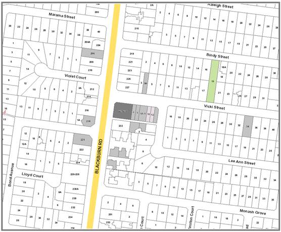
|
|
|
Subject site
|
|
22 Objector Properties
(10 outside of map, total of 24
objections)
|
é
North
|
BACKGROUND
History
The subject site was previously
used as a convenience shop, petrol station and restaurant. These buildings
were demolished in approximately 2010 and the site has been vacant since.
Application WH/2016/105 was
received on 16 February 2016 for the construction of a four storey building,
use of land for dwellings, reduction in car parking requirements and alteration
of access to a Road Zone (Category 1).
The application was advertised on
28 July 2016. A total of 24 objections were received from 22 objector
properties. A consultation forum was held on 29 November 2016, chaired by
Ward Councillor Massoud, and attended by 18 objectors and the planning officer
Subsequent to the matters raised at
this forum, a section 57A amendment was lodged on 30 January 2017 that reduced
the size and scale of the building. These plans were not readvertised.
The Site and Surrounds
The subject site is located on the
south-east corner of the Blackburn Road and Vicki Street intersection in
Blackburn South.
The site has a generally
rectangular shape with a splay at the north-west corner. It has frontages
to Vicki Street, Blackburn Road and a laneway along the southern
boundary. The laneway is approximately 3.3 metres wide. The site is
generally 32 metres deep and 28 metres wide with a total area of 896m2.
The site is generally flat and includes a number of crossovers along both
frontages owing to its previous use as a petrol station. There are no
trees on the site.
The surrounding land to the north,
west and south is residential in nature. Development in the surrounding
residential areas is predominately single and double storey detached dwellings
and townhouses. The land to the east is commercial in nature, with one
and two storey commercial buildings. Uses include a book shop, takeaway
food and offices. These commercial uses include rear access via a laneway.
Car parking is generally not provided on these sites. There are 13 angled
car parking spaces in Vicki Street with restricted parking of 15 minutes and 30
minutes during business hours.
Planning Controls
The land is located within a
Commercial 1 Zone and is subject to a Design and Development Overlay (Schedule
4). Blackburn Road is located within a Road Zone (Category 1).
A permit is required to construct
the building, to use the land for a dwelling, to reduce the required number of
car parking spaces and to alter access to Blackburn Road.
PROPOSAL
The application proposes the
construction of a three storey building including four offices and seventeen
dwellings. The proposal specifically includes:
· Basement
containing 31 car parking spaces and 19 storage cages. No residential
visitor’s spaces are to be provided.
· Vehicular
access via the rear laneway with ramp at the south-eastern corner of the
building.
· Ground
floor with four offices facing north to Vicki Street and one dwelling (three
bedrooms) facing west to Blackburn Road. Main dwelling entry to face
west. Bin storage with access to basement ramp entry.
· First
floor with nine dwellings (eight two bedrooms, one, one bedroom).
· Second
floor with seven dwellings (four two bedrooms, three one bedroom).
Refer to plans received 30 January
2017 by pointarchitects, revision C dated 15 November 2016.
CONSULTATION
Public Notice
The application was advertised by
mail to the adjacent and nearby property owners and occupiers and by erecting
notices to both street frontages and to the rear laneway. Following the
advertising period, 24 objections were received.
The issues raised are summarised as
follows:
Neighbourhood character
· Height
of the building at four storeys is out of character with the area.
· Overdevelopment
of the land.
· High
density development is not characteristic of the area.
Amenity impacts
· Overlooking
of adjacent properties.
· Increase
in noise impacts from the development and additional traffic.
· Amenity
impacts from rubbish collection.
· Overshadowing
of properties to the south.
· Visual
amenity impacts from clotheslines on balconies.
· Opening
hours of retail uses not clear.
Traffic and car parking
· Inadequate
on site car parking provision.
· Insufficient
on-street car parking provision to accommodate additional cars.
· Increase
in traffic in surrounding road network and resulting safety impacts.
· Rear
laneway is inadequate for the number of proposed vehicles.
· Insufficient
public transport infrastructure to support the proposal.
· Addition
of angled parking in Vicki Street will result in safety impacts for the Vicki
Street/Blackburn Road intersection.
· Increase
in traffic in the laneway.
· Unclear
which direction vehicles will exit the laneway.
· Car
stackers will discourage parking on site.
· Use
of the laneway for pedestrian access.
Other matters
· Insufficient
north facing balconies.
· Insufficient
waste disposal facilities within the building.
· Insufficient
landscaping provision.
· Lack
of access for retail uses to internal amenities.
· Ability
of residents to observe children walking to school.
· Increase
in street litter.
· Potential
damage to adjacent buildings during construction.
· Approval
may become a precedent for other developments.
· Insufficient
community facilities to accommodate the population increase.
· Impact
on sewerage infrastructure capacity.
· Residential
uses were not envisaged for this shopping strip.
· Increase
in property values.
Consultation Forum
A Consultation Forum was held on 29
November 2016. A total of 18 objectors and the applicant attended the
meeting, chaired by Councillor Massoud.
While no resolutions were reached
at the Forum, the applicant stated they would be willing to reduce the height
of the building by one storey in response to the objector’s concerns
about overdevelopment of the site.
Section 57A amendment
Subsequent to the advertising
period and Consultation Forum a Section 57A amendment was lodged on 30 January
2017 to address issues raised by referrals and objections raised where
possible. The primary changes include:
· Deletion
of the upper floor to reduce the building from four storeys to three.
· Deletion
of one ground level dwelling.
· Increase
in on-site car parking provision from 29 to 31 spaces.
These plans were not readvertised
as the changes will reduce the scale of the building. The objectors were
provided with an opportunity to view the plans prior to a decision being made.
Referrals
External
VicRoads
VicRoads provided comment under
section 55 of the Planning and Environment Act 1987, and did not object
to the proposal subject to the following:
· Other
laneway users must be granted the right to use the widened laneway by creating
it as a road or including a carriage way easement.
· No
corner splays at the laneway entrance will compromise pedestrian safety and
consideration should be given to exiting the site from the eastern end of the
laneway in to Vicki Street.
· Conditions
have been provided to be included on any approvals granted.
Further comment was sought from
VicRoads on 2 March 2017 in relation to the revised plans lodged on 30 January
2017. In response to the revised plans, they provided the following
comments:
· In
general, concerns previously raised by VicRoads are attended in the amended
plans.
· Concerns
previously raised by VicRoads regarding the vesting of the widened laneway area
within the site with Council as a road remain.
· With
the intensification of traffic in the laneway, it is important that visibility
splays are provided as per the planning scheme and Australian Standards.
It is noted that the land on the southern side of the laneway is not under the
control of the permit applicant and as such a splay cannot be provided
here. Mitigation works may be required to highlight the area of conflict
to both drivers and pedestrians.
Public Transport Victoria
Although not a referral authority,
PTV made the following comments:
· PTV
does not object to the proposal based on increased patronage.
· PTV
generally does not seek to refuse applications on the basis of an increase in
patronage numbers.
Internal
Transport Engineer
Council’s Transport Engineer
has provided the following comments:
· A
reduction in visitors’ car parking spaces could be supported provided the
reduction in spaces is made up by additional spaces being provided in the Vicki
Street frontage.
· On-street
car parking in Blackburn Road is not supported as it is considered to be a
safety issue due to its location on a main road and their proximity to the
Vicki Street and Blackburn Road intersection.
· No
issues are raised in relation to traffic generation. The proposal will
result in approximately 190 movements a day, of which 110 will be
residential. The basement layout will generally prevent vehicle movements
to Vicki Street and Lee Ann Street with the majority of traffic generation
increases to be limited to Blackburn Road which is capable of accommodating
these additional movements.
· Bicycle
parking on Council land will not be supported and should be deleted.
· Height
clearances within the basement and basement ramp should be identified on the
plans.
· The
basement ramp gate should be relocated to the base of the ramp to remove the
need for cars to prop on a 1:5 ramp gradient while waiting for the gate to
open.
· It
is recommended that all spaces be accessible by driving in forwards rather than
in reverse.
· Stacker
models need to be clearly identified and comply with Clause 52.06 (Car
parking).
· It
is unclear how long the stackers take to retrieve cars.
· The
turning movements have not taken in to account columns, doors and platform
widths. Visibility from these spaces might be impacted.
· A
traffic signal system will be more appropriate for the single-width ramp rather
than a convex mirror.
· The
grill at the top of the ramp providing visibility for vehicles should include
additional detail.
· Comment
should be sought from Council’s Asset Team in relation to the use of the
laneway for access.
· A
sight-line triangle should be provided at the south-west corner of the
building.
· A
parking management plan will be required clarifying allocation of parking
spaces, signing of parking spaces, line marking, security and how visitors will
access the basement.
· No
loading facilities are required.
· Comment
should be sought from Council’s Waste Engineers.
Waste Engineer
Council’s Waste Engineer has
reviewed the proposal and the submitted Waste Management Plan (WMP) and noted
that it is not satisfactory. Specifically:
· The
WMP needs to be updated to reflect the current plans in relation to waste
generation, mobile garbage bin types and size and collection frequencies.
· The
bin storage area needs to meet Council’s requirements.
· The
collection of bins via private operator from Blackburn Road needs to comply
with Council’s standards which much be reflected in the WMP. Where
these cannot be achieved, on site collection must be used.
· Once
approved, the WMP can only be amended with Council’s permission.
· All
aspects of the waste management system are to be the responsibility of the site
manager and not the collection contractor.
· Rubbish
bin specifications are to be provided to the satisfaction of the Council.
· It
is noted the waste collection is to be undertaken by private contractor from
Blackburn Road, and Council issued bins will not be required.
· Bin
usage is based on shared usage by occupiers.
Assets Engineer
Council’s Asset Engineers
have provided conditions and notes to be placed on any approval granted.
They have requested that the
laneway be re-constructed to Council’s Standards where adjacent to the
rear boundary of the site (approximately 32 metres). They have also
requested that the widened laneway area at the western end of the site be constructed
to Council’s standards to match the laneway, but that this land remain in
the ownership of the subject site but a carriageway easement be included.
No issues are raised with the
removal of crossovers in Vicki Street. A pedestrian access ramp can be
installed in Vicki Street to service the disabled spaces.
ESD Advisor
Council’s ESD Advisor has
reviewed the proposal and noted that a number of matters need to be further
clarified on the plans. It has also been suggested that the following
items be included in the proposal:
· Skylights
be included at the top level corridors and stairs.
· Include
insect screens for openable windows and encourage natural ventilation.
· Include
ceiling fans within the building.
· Use
a light coloured or reflective roofing material.
· Minimise
the amount of south facing windows to reduce heat loss during winter.
Property and Rates
Council’s Property and Rates
Department made the following comments:
· A
section 173 agreement will be required to be entered into by the land owner in
relation to the canopy overhanging the Vicki Street footpath for the provision
of public liability insurance. A permit note relating to rights for the
occupation of Council land will be required on any approval.
· The
inclusion of a canopy over the western footpath will require the permission of
VicRoads. It is noted that VicRoads have required any canopy over the
western footpath be removed and this is a condition of approval.
· No
area has been nominated on the plans for site offices and storage during the
construction phase. The laneway must not be used for this purpose.
DISCUSSION
Consistency with State and Local
Planning Policies
The proposal is considered to be
consistent with the State Planning Policies.
The proposal acceptably responds to
Clause 15.01 (Urban Environment) in relation to the context of the commercial
character of the land. The proposal, at three storeys, provides a
reasonable transition between the commercial nature of the site and the
lower-scale residential development within the surrounding area. While no
substantial landscaping areas are proposed, this is consistent with the other
commercial buildings in the Vicki Street Activity centre. The proposal
will retain suitable activation at the ground floor with four commercial tenancies
facing Vicki Street, complementing the existing development pattern.
The proposal acceptably responds to
Clause 16.01 (Residential Development) by increasing the supply of housing in
an under-utilised commercial site. The increase in housing in this
location will have a positive effect on the viability of the existing activity
centre by introducing a larger population within close proximity of an activity
centre that can easily be accessed by walking. The proposal will also
introduce a wider range of housing types for this area of Blackburn South which
generally includes only one and two storey detached dwellings and townhouses.
The proposal acceptably responds to
Clause 17.01 (Commercial) in that it will increase the commercial capacity of
this activity centre and provide opportunities for diversified uses fitting
within the commercial purposes of the land. The scale of the tenancies
are consistent with the existing tenancies, with the exception of the book shop
at 4-8 Vicki Street which includes four separate sites.
The proposal acceptably responds to
Clause 21.06 (Housing) in that it will provide additional housing to achieve
Whitehorse’s projected housing growth, will ensure that Council meets its
objectives of increasing housing and employment densities in activity centres
and provides additional diversity of housing styles.
The proposal acceptably responds to
Clause 21.07 (Economic Development) in that it will result in a revitalisation
of a vacant site with a scale of development and proposed uses that are
complementary to the existing commercial activity centre, while respecting the
sensitive interfaces to the south across the laneway.
The proposal acceptably responds to
Clause 22.06 (Activity Centres) in that the scale of commercial tenancies is
consistent with the other commercial uses in the activity centre, it will
improve the visual amenity of the area through a modern building with
acceptable levels of ground floor activation and the focus on office uses is an
acceptable response given this activity centre does not focus heavily on
retailing.
Design and Built Form
Design and Development Overlay
The Design and Development Overlay
(DDO) sets out the preferred built form response for this area.
Pursuant to Schedule 4 of this
Overlay, the site is within the Neighbourhood Activity Centre Category 1A
(small-medium neighbourhood centre on a standard width road). Within 1A,
buildings should achieve the preferred maximum height of 11.0 metres (three
storeys) and satisfy the preferred side boundary setbacks. In relation to
these requirements, the proposal responds as follows:
· The
building would be three storeys and 11.4 metres in height. This fails the
preferred height.
· The
buildings would have a zero front setback at the ground and first floor, then
3.0 metres at the second floor to the north and west.
· The
building would be setback 1.0 metre from the rear laneway at the ground and
first floor, and 6.0 metres at the second floor.
· The
building would be built to the eastern boundary.
While the proposal would fail to
achieve the preferred height of 11.0 metres, it is considered the design
objectives of the DDO will be satisfied as the building will achieve the
preferred three storey height and the non-compliance varies from 0 metres to 400mm.
In the context of a three storey building, the additional 400mm is not
considered to be an unreasonable increase and will generally satisfy the intent
of the Overlay to limit buildings to three storeys.
The setbacks of the building either
comply with the DDO4, or exceed them.
On this basis it is considered the
size and height of the building is consistent with the relevant planning
controls and will acceptably respond to both the activity centre and the more
sensitive residential interface to the rear.
Commercial 1 Zone
Although the Commercial 1 Zone does
not set out any built form principles, it requires the Responsible Authority to
consider a number of decision guidelines.
In response, it is noted that the
proposal has taken into account and provided satisfactory pedestrian, bicycle
and vehicular movement into and out of the site.
The proposal includes an acceptable
provision of car parking; the streetscape presentation to both street frontages
is acceptable and provides adequate activation.
The proposal includes an acceptably
sized bin room located away from the streetscapes.
Overlooking and overshadowing
impacts have been acceptably managed and the dwellings satisfactorily respond
to Rescode.
Clause 55 (Rescode)
Light access
Light access in to most dwellings
is generally acceptable. It is noted that daylight to Bed 2 and 3 of
Dwelling G.05 and Bed 1 of Dwelling 1.7 are compromised in terms of access to
daylight. However, in the context of the building, this is considered an
acceptable response as the majority of dwellings will receive adequate natural
light.
Balconies
The balcony of Dwelling 1.3 is, at
7m2, is less than the Rescode requirement and should be increased to
8m2 to ensure this dwelling has an acceptable area dedicated to open
space.
It is noted that the balconies for
Dwellings 1.1, 1.2, 1.7, 1.8, 1.9 and 2.7 are south facing. The Balconies
for Dwellings 1.2, 1.7 and 1.8 include an eastern or western interface and are
acceptable. Balconies for Dwellings 1.1, 1.9 and 2.7 will be entirely
south facing. However, they are considered acceptable as they are of
acceptable dimensions, and will have no roof overhang, maximising natural light
access. It is recognised that not every dwelling within the development
can include north facing balconies due to the size and orientation of the lot
and that the majority of dwellings can access north, east or western light.
This is an acceptable response.
Letter box location
Letter boxes are to be located
within the main dwelling entry lobby. They should be relocated outside of
the lobby to ensure they can be accessed at all times by Australia Post.
This will be a condition of approval.
Internal corridors
To maximise energy efficiency, the
second floor internal entry corridor should be modified to include
skylights. This will be a condition of approval.
Accessibility
The entries of the ground floor of
dwellings and residential buildings should be accessible or able to be easily made
accessible by people with limited mobility. Dwelling G.05 will be located
1.0 metre above the ground floor internal accessway to ensure the stacker
arrangement in the basement has adequate head height.
While this response does not allow
Dwelling G.05 to be accessed by people with limited mobility, it is noted that
the building as a whole beyond this dwelling is accessible, as the main
dwelling entry is at the footpath level and there is a lift servicing all
floors.
Noise impacts
The location of Bed 2 and 3 of G.05
facing the laneway will result in a poor amenity outcome for these rooms.
While it is noted that the floor level of this dwelling will be approximately
1.0 metre above the laneway level, it is considered that these windows should
be double glazed to minimise noise impacts. The window locations will
have a poor outlook in this direction; however this is considered acceptable as
the main internal living areas will face a large balcony to the west.
Storage
The basement shows 19 storage
cages. However, these are not dimensioned. Dimensions must be shown
on the plans to ensure these storage areas will achieve a minimum volume of 6m3.
Landscaping
The provision of substantial areas
of landscaping is not considered to be an appropriate response for the
commercial context of the land, where there is an emphasis on providing for
substantial development and buildings generally occupy the majority, if not
all, of the land.
However, in response to the
residential interface at the southern boundary, the proposal will include two
rain gardens along the southern boundary of the site, at the laneway entrance
and to the south of the basement ramp, which will provide some relief from the
extent of built form at the interface with the residential land to the south of
the laneway.
Additionally, two planter boxes are
proposed at the second floor on the south elevation. Both planter boxes
will be 1.4 metres in depth, with the western box 12.4 metres long and the
eastern box 6.8 metres long. This will provide some variation to the
built form presentation of the building to the south and are an appropriate
response.
A condition of approval will
require a landscaping plan detailing the proposed species to be planted and how
these areas are to be maintained and irrigated.
Car and Bicycle Parking
The current proposal has a car
parking demand of 34 spaces based on:
· 389m2
of office floor area requiring 13 spaces;
· One
three bedroom dwelling requiring two spaces;
· Twelve
two bedroom dwellings requiring 12 spaces;
· Four
one bedroom dwellings requiring four spaces; and
· Three
residential visitor’s spaces. This is a reduction from four
residential visitor’s spaces based on the 21 dwellings proposed by the
advertised plans.
The proposal includes 31 car
parking spaces in the basement. Consequently, there is a shortfall of
three spaces. The reduction is considered acceptable despite the high car
parking demand in the area as the deletion of the redundant crossovers in Vicki
Street will allow three additional angled spaces to be reclaimed, which will
offset the parking reduction.
The removal of the redundant
crossovers and line marking of new spaces is to be carried out by the permit
holder to the satisfaction of the Responsible Authority. The spaces will
be subject to time restrictions to the satisfaction of the Responsible
Authority, and will not be limited to the exclusive use of the proposed
development. Council’s Transport Engineers are supportive of this
approach provided the car parking reduction is for residential visitors
only. This will be achieved through a car parking management plan which
will allocate car parking spaces within the basement to the dwellings and
commercial staff only. It is accepted by the Transport Engineers that
residential visitors generally attend the land outside of business hours.
While there will be an additional
190 movements a day generated by the development, the basement entry
arrangement will prevent movement in and out of the site via the eastern end of
the laneway. Given traffic will enter and leave via Blackburn Road; it is
considered there will be minimal impact on the number of existing traffic
movements in the local road network beyond Blackburn Road. As the laneway
will be increased to 6.0 metres in width and allow full two-way access in to
and out of the basement, the access layout will result in an acceptable outcome
for traffic movements.
A number of additional details will
need to be shown on the basement and elevation plans to ensure the basement
layout is acceptable, including head height clearances, relocated gate, stacker
models clearly identified, swept path diagrams taking into account columns and
platform widths, a traffic signal system and additional details for the grill
at the top of the ramp. While a parking management plan has been
requested by Council’s Transport Engineers, it is considered the matters
of line marking and space allocation can be clarified on the basement plans,
particularly so as no visitors will need to enter the basement. Despite these
details still being required, sufficient information has been provided to
assure officers that the basement in its current configuration can accommodate
the necessary vehicle parking and movements.
Bicycle parking must be provided at
a rate of one space per 300m2 of office area and none for the
dwellings. A total of seven bicycle parking spaces are to be provided at
the ground floor and this is considered an acceptable response, allowing the
parking spaces in the road reserve to be deleted without affecting the bicycle
parking requirements.
No loading bay is required as the
commercial tenancies are to be used as offices.
Amenity
Overshadowing to the south
The submitted shadow diagrams for
the equinox indicate that the extent of shadows cast to the south of the site
will be in full compliance with Standard B21 (Overshadowing). The
majority of the shadow will fall on the laneway.
Overlooking to the south
There are a number of windows and
balconies oriented to the south. At the ground floor, the bedroom windows
for Dwelling G.05 will be set back from the northern boundary of 233 Blackburn
Road by 6.0 metres and will be adequately screened by boundary fencing.
At the first floor, there will be
five windows and three balconies facing south. All of these will be
screened with obscure glazing to 1.7 metres above the finished floor level.
At the second floor, there will be
balconies with a length of 28 metres facing south. These will be screened
by obscure glazing to 1.7 metres above the finished floor level.
All windows facing residential
properties will be adequately screened in accordance with Standard B22 of
ResCode. It is noted that Dwellings 1.1, 1.9, 2.1 and 2.7 will include
screening to balconies and Dwelling 1.1 to the south facing bedroom
windows. This is considered an acceptable outcome as each of these
dwellings will include windows that are not screened and balconies that are not
encumbered by roofs, allowing for views out of the site and for natural light
to penetrate in to the dwelling interiors.
Noise impacts
It is not considered the office
uses will cause any amenity concerns for the surrounding residential
areas. They will be located away from the properties to the south of the
site and will be consistent with the existing activity centre layout facing
Vicki Street.
While there will be an increase in
the number of traffic movements in the laneway, these will be limited to where
adjacent to 233 Blackburn Road. The laneway in this location is already subject
to vehicular noise from Blackburn Road and it is not considered any additional
movements will unreasonably impact the amenity of this dwelling.
Objectors Concerns
Neighbourhood character
· Height
of the building at four storeys is out of character with the area.
The height of the building has been
reduced and is now substantially in accordance with the DDO4. While three
storeys is one storey higher than most buildings in the area, it is still
considered to be consistent with the intent of the Commercial 1 Zone, related
local policies, and the site’s location on a main road.
· Overdevelopment
of the land.
The proposal is not considered to
be an overdevelopment of the land. The height of the building at three
storeys is consistent with the DDO4 and the side boundary setbacks comply with
the DDO4. Adequate car parking is provided on the site and while no
substantial landscaping areas are provided within the site, this is considered
acceptable in commercial areas.
· High
density development is not characteristic of the area.
Developments at higher
densities are consistent with the policies and objectives of commercially zoned
land.
Amenity impacts
· Overlooking
of adjacent properties.
As noted above, there will be no
unreasonable overlooking of nearby properties.
· Increase
in noise impacts from the development and additional traffic.
As noted above, there will be no
unreasonable noise impacts on nearby properties.
· Amenity
impacts from rubbish collection.
Waste is to be collected from
Blackburn Road, consistent with other developments in the area. While the
intensity of waste collection will be increased, it is considered to be
reasonable in the context of Blackburn Road.
· Overshadowing
of properties to the south.
As noted above, there will be no
unreasonable overshadowing of nearby properties.
· Visual
amenity impacts from clotheslines on balconies.
This is not a relevant planning
matter. Laundries are provided within each dwelling.
· Opening
hours of retail uses not clear.
The use of the offices does not
require a planning permit and as such there is no ability to control the hours
of operation.
Traffic and car parking
· Inadequate
on site car parking provision.
As discussed above, the car parking
provision is considered acceptable.
· Insufficient
on-street car parking provision to accommodate additional cars.
The deletion of redundant
crossovers will allow for the reclamation of three on-street parking spaces.
· Increase
in traffic in surrounding road network and resulting safety impacts.
As discussed above, the increase in
traffic in the surrounding road network is considered acceptable.
· Rear
laneway is inadequate for the number of proposed vehicles.
No issue with the intensity of use
of the laneway has been raised by Council’s Transport Engineers.
· Insufficient
public transport infrastructure to support the proposal.
PTV has been consulted and they
have raised no issues with the proposal.
· Addition
of angled parking in Vicki Street will result in safety impacts for the Vicki
Street/Blackburn Road intersection.
No issues have been raised by
Council’s Transport Engineers or VicRoads in relation to the impact of
the new parking spaces on the safety of this intersection.
· Increase
in traffic in the laneway.
It is considered any
increase in traffic in the laneway will not unreasonably impact the surrounding
area. Additional traffic will be limited to the western end of the
laneway where it connects with Blackburn Road.
· Unclear
which direction vehicles will exit the laneway.
Vehicles can only exit the site to the west, to Blackburn
Road, due to the layout of the basement ramp.
· Car
stackers will discourage parking on site.
Car stackers are an acceptable form
of parking and are permitted by the planning scheme.
· Use
of the laneway for pedestrian access.
It is not proposed to use
the laneway for pedestrian access. Nevertheless, it is not considered
there will be any unreasonable impacts from additional pedestrians using the
laneway.
Other matters
· Insufficient
north facing balconies.
While it is not possible to provide
a north facing balcony for every dwelling, it is considered the proposal has
adequately responded to the constraints of the site and the number of north
facing balconies is acceptable.
· Insufficient
waste disposal facilities within the building.
A revised Waste Management Plan
will be required to ensure the bin room at the ground floor is of adequate
size.
· Insufficient
landscaping provision.
As noted above, landscaping is not
a built form outcome sought to be protected by the Commercial 1 Zone.
· Lack
of access for retail uses to internal amenities.
The plans submitted on 30 January
2017 include acceptable access for the commercial uses to the internal
amenities areas.
· Ability
of residents to observe children walking to school.
This is not a relevant planning
matter.
· Increase
in street litter.
This is not a relevant planning
matter.
· Potential
damage to adjacent buildings during construction.
This is not a relevant planning
matter and is the responsibility of the relevant building surveyor. The
surveyor will be required to ensure the EPA and building regulations relating
to the protection of adjacent land is satisfactorily enacted and managed.
· Approval
may become a precedent for other developments.
This is not a relevant planning
matter. All applications are assessed on their own merits.
· Insufficient
community facilities to accommodate the population increase.
The addition of 17 dwellings to a
well-established suburban residential area will not unreasonably impact the
capacity and availability of community facilities.
· Impact
on sewerage infrastructure capacity.
No evidence has been provided to
indicate that sewerage infrastructure will be unreasonably impacted by the
proposal.
· Residential
uses were not envisaged for this shopping strip.
Dwellings are an allowable use in
commercial areas and are encouraged by State and Local policies encouraging
urban consolidation and more efficient use of land, particularly where located
above commercial uses
· Increase
in property values.
This is not a relevant planning
matter.
CONCLUSION
The proposal for the construction
of a three storey building for four offices and seventeen dwellings, use of the
land for a dwelling, reduction in the required car parking provision and
alteration of access to a Road Zone (Category 1) is an acceptable response that
satisfies the relevant provisions contained within the Whitehorse Planning
Scheme, including the State and Local Planning Policies, the Commercial 1 Zone,
the Design and Development Overlay (Schedule 4) and Clause 55, ResCode.
The height and scale of the
building is responsive to the commercial zoning of the land and the residential
interface to the south. The size and layout of the commercial uses will
be consistent with the existing commercial developments to the west of the site
and the internal amenity for the dwellings will be acceptable. The car
parking provision and layout is acceptable and will not unreasonably impact the
on-street car parking provision or traffic volumes in the surrounding road
network.
A total of 24 objections were received
as a result of public notice and all of the issues raised have been discussed
as required.
It is considered that the
application should be approved.
Attachment
1 WH 2016 105 -
Application to Amend a Planning Application - Plans
⇨ 
Ordinary Council Minutes 18
April 2017
Strategic
Planning
9.1.3 Amendment
C192 to the Whitehorse Planning Scheme - Consideration of exhibition period and
submissions received
SUMMARY
Amendment C192 was on public
exhibition from 2 February until 3 March 2017. Two submissions were received
about the amendment, one opposing and one in support.
This report discusses the issues
raised during the exhibition period by the submissions received and recommends
that the amendment and the submissions be referred to an independent Planning
Panel for consideration.
|
Council
Resolution
Moved by Cr Munroe,
Seconded by Cr Ellis
That Council:
1. Being
the Planning Authority, having considered the submissions in relation to
Amendment C192, request the Minister for Planning appoint an Independent
Panel to consider the Amendment and the submissions in accordance with the
Planning and Environment Act 1987.
2. Advise
all submitters of the request for an Independent Planning Panel.
Carried Unanimously
|
background
On 11 October 2016
Council received a request to consider an amendment to the Whitehorse Planning
Scheme (Planning Scheme). The request concerned the sites at 119 Surrey Road
and 150-152B Springfield Road, Blackburn (see Figure 1 for location of sites).
The request sought to rezone the land at 119 Surrey Road and 150-152B
Springfield Road, Blackburn from the General Residential Zone – Schedule
1 (GRZ1) to the Commercial 1 Zone (C1Z) and apply the Design and Development
Overlay – Schedule 4 (DDO4) to the land. The request also sought to apply
an Environmental Audit Overlay (EAO) to 119 Surrey Road, Blackburn.
At the Council
Meeting on 21 November 2016, Council resolved to seek authorisation from the
Minister for Planning to prepare and exhibit Amendment C192 to the Planning
Scheme. The Minister for Planning granted authorisation on 6 January 2017.
Figure 1: Location of sites
Exhibition of Amendment
Exhibition of the amendment
occurred in the form prescribed by the Planning and Environment Act 1987.
Exhibition was for one calendar month and took place from Thursday 2 February
until Friday 3 March 2017. Exhibition involved the direct notification of
owners and occupiers of properties surrounding the subject sites, totalling 547
letters. The notification of properties in the area included a cover letter
explaining the amendment and how to find out further information, and the
statutory notice of amendment.
Relevant Ministers, public and
referral authorities were also notified, together with the publication of the
Notice of Preparation of Amendment in the Whitehorse Leader on 30 January 2017
and the Government Gazette on 2 February 2017.
For the duration of the exhibition
period copies of the amendment documents were available for viewing on
Council’s website and in hardcopy at Council’s Civic Centre in
Nunawading, Council’s Box Hill and Forest Hill Service Centres and the
libraries in Whitehorse.
Submissions
During the exhibition Council
officers received several phone and counter inquiries regarding the amendment.
During the exhibition period two submissions were received to the amendment,
one opposing and one in support.
DISCUSSION
Support for
the amendment
The Environment
Protection Agency (EPA) supports the proposal to apply an EAO over the subject
land based on the provided site history and does not have objection to the
amendment.
Objection to
the amendment
One submission
opposed the amendment. The submission raised the following issues:
Exhibition
documents
During the
exhibition period the submitter asked for the documents produced by the
proponent to request the amendment to the Planning Scheme. In the submission,
the submitter contends that these documents should be available and that the
documents used to request the amendment contains information which contradicts
the amendment documentation prepared by Council officers. The submitter also
argues that the amendment request documents disclose information about the
future intent of the landowner for the sites included in the amendment.
Officer Response
The submitter was
advised on numerous occasions during the exhibition period that:
· The request and documentation received from ARG Planning was merely
the process which ARG Planning used to request the amendment and is not
materially relevant to the amendment process;
· The amendment is for the rezoning of the land and application of the
two overlays and the request documents do not include any development proposal;
· The request documentation does not form part of the statutory
amendment process placed on exhibition;
· The amendment documentation that was on public exhibition and
available for review (which included the Explanatory Report, Instruction Sheet
and mapping) is what was assessed by the Minister for Planning when he
considered the request by Council to authorise the amendment for exhibition and
is what Council was required to make available during the statutory exhibition
period under the Planning and Environment Act 1987.
Explanatory
Report
The submitter
raised concerns about the information contained in the Explanatory Report, as
follows:
1. The Explanatory Report states that the
Amendment is required because the sites “are not used for residential
purposes. The rezoning of the land from GRZ to C1Z will reflect the ongoing use
for commercial purposes”. The submitter contends that there will be no
change as the sites are already used for commercial purposes and the existing
car wash is not prohibited under the GRZ. The submitter also states that sites
will be able to be exploited for residential uses.
2. The Explanatory Report states that the
Amendment will “ensure that development preserves the amenity and
character of abutting residential areas. The submitter states that most
effective way to preserve the amenity of the area is for it to be retained in
the GRZ. The submitter contends that the rezoning will allow commercial
enterprises which will affect adjoining land and create amenity issues such as
noise, traffic, hours of delivery and operation, light spill, solar access and
glare.
3. The Explanatory Report states that the
Amendment will “provide certainty for future built form outcomes”,
however the submitter believes this to be untrue as the DDO4 uses the word
‘preferred’ rather than ‘must’. The maximum height
stated is a “preferred” 3 storeys or 2 storeys if adjoining a
residential area. The submitter believes that the word maximum is misleading
since Council and ultimately the Victorian Civil and Administrative Tribunal
(VCAT) are not bound by the “maximum” storey levels and that a
developer can apply to construct a development in excess of this
“maximum”.
The submitter
believes that the existing GRZ can provide greater certainty together with a
DDO rather than a C1Z and that a new DDO schedule which restricts the building
height to 2 storeys should be sought, as the current “preferred”
building height of 3 storeys cannot be enforced by Council should the matter be
brought before VCAT.
4. Finally the submitter contends that the
introduction of the Amendment seems to have no practical impact except if there
is a clear and present purpose to the sites’ proposed use which has not
yet been explained in the Explanatory Report and to the community.
Officer Response
1. The amendment is to rezone the subject sites
and apply an EAO to 119 Surrey Road, Blackburn. The amendment does not imply,
or require, the development of the subject sites and the uses that currently
exist have pre-existing use rights to continue to operate. The rezoning to C1Z
recognizes the long standing commercial uses of the subject sites, the typical
commercial nature of the lot configuration and its location adjacent to an
existing NAC. The application of the DDO4 incorporates the subject sites into
the existing NAC, and therefore the C1Z is the more appropriate zone as it
reinforces the NAC designation.
The existing GRZ
allows residential uses, however the proposed C1Z will allow for commercial and
retail uses, such as the existing uses, some of which would otherwise be
prohibited. The uses will help to create active frontages along Springfield and
Surrey Roads in the NAC.
2. If a development application is lodged
for any of the subject sites in the future, it will be assessed against the
current zone and schedule requirements such as, but not limited to, height,
setbacks, site coverage, open space and car parking.
Any future development of the site
will also need to be cognisant of the surrounding residential uses and
neighbourhood character and amenity impacts will be assessed against the
requirements of the Planning Scheme.
The NAC Urban Design Guidelines
would also need to be considered by any future development. The Guidelines are
also noted in the DDO4 (Schedule 4 to Clause 43.02 of the Planning Scheme) and
include the following general objectives:
· Development
will be designed to facilitate a lively, attractive and safe local activity
centre, and assist in improving its economic viability;
· New
development will be designed to respond to the immediate site environs, reflect
the role of the centre and enhance the character of the surrounding residential
area;
· The
detailed design of buildings will provide a high quality and visually
interesting interface with the streetscape (including internal streets within
larger centres) and the surrounding residential area, ensuring issues of amenity,
functionality, adaptability and accessibility are addressed;
· New
buildings will create a complementary interface to enhance the public realm
surroundings;
· New
developments will be designed to minimise potential off site impacts such as
noise (including from services), overlooking, access to sunlight, and light
spillage on adjoining residential properties; and
· The
public realm will be designed to complement the function of the centre and the
character of its surrounding residential area. Design should respond to
surrounding public realm and enhance character and amenity.
If a planning permit is required
under the planning scheme for such development, surrounding neighbours will be
notified of the application and given the opportunity to submit their views
about the application to Council, as per current statutory planning processes.
3. The
application of the DDO4 will provide certainty to future built form outcomes.
DDO4 has a preferred maximum height of 3 storeys in a small-medium neighbourhood
centre, with a preferred maximum height on a boundary adjoining a residential
area of 2 storeys. The third storey of a building is required to be setback a
preferred minimum of 5 metres at the rear boundary.
This will ensure a pleasant and safe
living and recreational environment, as the setbacks will allow development to
respect the low scale built form of surrounding residential areas and reduce or
prevent overshadowing to adjoining residential properties.
The state government has recently
reviewed the residential zones and introduced reformed zones. The reformed GRZ
includes a height control for buildings of 11m/3 storeys. The DDO4 includes a
height control of 11m/3 storeys for Category 1A NACs, such as the centre at
Springfield and Surrey Road. Whilst the reformed GRZ heights are mandatory and
the DDO4 heights discretionary, developments that seek to exceed the preferred
height (in the Commercial 1 zone) will be required to justify the additional
height against the objectives of the DDO4 and the character of the surrounding
residential precinct. Any application to exceed the preferred maximum height
needs to be justified against the objectives of any zone and overlay that apply
to the land, as well as the characteristics of the surrounding land. Any decision
could be reviewed by VCAT (if sought).
4. The amendment proposes to rezone the sites
together as they are included in a residential zone, but are not used for
residential purposes and do not present as a residential precinct typical of
the surrounding character. The proposed rezoning of the land from GRZ1 to C1Z
will reflect the ongoing use for commercial purposes. The proposed
rezoning will facilitate the use of the subject land in a manner which is
consistent with the NAC and which will ensure a consistent approach is taken to
its future development in accordance with other NACs within the municipality,
in particular, to the Springfield and Surrey Road Shops NAC opposite. It will
also ensure that development preserves the amenity and character of abutting
residential areas.
As this amendment request is only
to rezone and apply the two overlays, there are no proposals at this time for
the use of the subject sites and no development plans have been submitted to
Council. However, the landowners are entitled to develop the land in accordance
with the planning controls and lodge an application for a development with
Council in the future.
CONSULTATION
Exhibition of the amendment
occurred in the form prescribed by the Planning and Environment Act 1987.
Owners and occupiers in the surrounding area, relevant Ministers and referral
authorities were notified, together with the publication of the Notice of
Preparation of Amendment in the Whitehorse Leader and the Government Gazette.
For the duration of the exhibition
period copies of the amendment documents were available for viewing on
Council’s website and in hardcopy at Council’s Civic Centre in
Nunawading, Council’s Box Hill and Forest Hill Service Centres and the
libraries in Whitehorse.
FINANCIAL
IMPLICATIONS
The proponent is required to pay
for all costs associated with the independent Planning Panel hearing. The
proponent will also have to pay the relevant fees for the adoption and approval
of the amendment.
Council does not have to pay any
costs involved in the amendment with the exception of any expert witnesses
and/or representation in support of Council at the Panel hearing. This
representation can be funded from the current budget however it is expected
that Council officers will represent Council at the Panel Hearing and that no
expert witness will be required on Council’s behalf.
POLICY IMPLICATIONS
The proposed amendment will meet
two strategic objectives in the Council Plan, including:
Strategic Direction 2: Maintain
and enhance our built environment to ensure a liveable and sustainable city.
This direction is proposed to be
achieved by improving the links and usage of transport modes with regard to
efficiency, sustainability and safety. Rezoning the land to C1Z supports this
as the sites are located at the intersection of Surrey Road
and Springfield Road, near to bus routes and with pedestrian access along both
Surrey Road and Springfield Road. This allows for sustainable access to the
sites by using public transport and active transport and will maintain the
built environment in this area. The amendment also allows for the potential
future development of the sites which would utilise
local transport modes to access the broader area.
DDO4 aims to
ensure that new development is designed to facilitate an attractive activity
centre and that new buildings create a complementary interface to enhance the
public realm and respond sensitively to adjoining development. Therefore the
application of the DDO4 will assist in new development enhancing the built
environment in the local area.
Strategic Direction 5: Support a
healthy local economy
This direction is proposed to be
achieved by supporting the development of a sustainable, growing local economy
and supporting the commercial and retail sectors. The proposed rezoning to C1Z
will support this direction as it recognises the existing uses and allows for
the future development of commercial and residential uses. This will support
the local and broader economy and provide complementary uses to the current
services and shops in the surrounding area, including the existing NAC. The C1Z
also allows for future commercial and residential uses, which will also support
the local economy through construction and commercial jobs.
CONCLUSION
Amendment C192 seeks to rezone 119
Surrey Road and 150-152B Springfield Road, Blackburn from the General
Residential Zone to the Commercial 1 Zone. The amendment also seeks to include
the properties in Design and Development Overlay Schedule 4 and apply an
Environmental Audit Overlay to 119 Surrey Road, Blackburn.
Officers consider that the proposed
rezoning of the land from the General Residential Zone to the Commercial 1 Zone
to be appropriate. The rezoning will facilitate the future development of the
sites with uses that are consistent with the longstanding commercial use of the
land and the strategic location at the intersection of two roads. The rezoning
will allow development that provides for a range of uses that complement the
existing Neighbourhood Activity Centre.
The amendment received two
submissions during the exhibition period. One of the submissions objected to
the amendment and one submission from the EPA agreed with the application of
the EAO and had no concerns with the amendment.
In considering submissions to an
amendment Council can change the amendment in the manner requested, refer the
submissions and amendment to an independent Planning Panel or abandon the
amendment. As there is a submission that seeks changes to the amendment which
cannot be supported, the first option cannot be considered.
As the amendment can be supported
on a strategic basis, it should not be abandoned. Accordingly, the most
transparent and fair method to enable all parties to have their comments
assessed is for the submissions and the amendment to be referred to an
independent Planning Panel for its consideration. Therefore it is recommended
that the amendment is referred to an independent Planning Panel and that
submitters are advised accordingly.
Ordinary Council Minutes 18
April 2017
Engineering and Environmental
9.1.4 EAGA
Memorandum of Understanding 2017-2021
FILE NUMBER: 17/38790
ATTACHMENT
SUMMARY
The purpose of this report is to
outline the programs, projects and advocacy actions undertaken by the Eastern
Alliance for Greenhouse Action (EAGA) of which Whitehorse Council is a member,
and to present a draft Memorandum of Understanding for Council’s ongoing
participation in the Alliance for the next four years (2017-2021). It is
recommended that Council endorse and sign the draft EAGA Memorandum of
Understanding and continue its participation in EAGA.
|
Council
Resolution
Moved by Cr Cutts,
Seconded by Cr Bennett
That Council:
1. Endorse
and authorise the CEO to sign the Eastern Alliance for Greenhouse Action
(EAGA) Memorandum of Understanding covering the period 2017-2021;
2. Continue
its participation in the Eastern Alliance for Greenhouse Action (EAGA) for
the duration of the proposed Memorandum of Understanding; and
3. Advise
EAGA and the other participating EAGA Councils accordingly.
Carried
Unanimously
|
NB: Cr
Davenport requested that his vote against this item be recorded.
background
Council resolved in March 2008 to
strongly support the formation and membership of the Eastern Alliance for
Greenhouse Action (EAGA). EAGA was formed later in 2008 as a voluntary regional
group of eastern Melbourne Councils. The EAGA member Councils are Boroondara
City Council, Knox City Council, Maroondah City Council, Monash City Council,
Stonnington City Council, Whitehorse City Council and Yarra Ranges Shire
Council.
Council further resolved in
February 2012 to endorse changes to the governance structure and financial
arrangement of EAGA, principally the engagement of a dedicated alliance
coordinator and the engagement of a Councillor representative on EAGA’s
Executive Committee. Whitehorse Council is currently represented on the EAGA
Executive Committee by Cr Prue Cutts.
The current Memorandum of
Understanding (MOU) that provides the formal commitment for participating
Councils to collaborate as a regional greenhouse action alliance expires on 30
June 2017.
EAGA is one of 10 established
greenhouse alliances in Victoria representing over 80% of local governments.
These regional partnerships are providing an effective collaboration and
leadership model that allows for climate change mitigation and adaptation projects
to be implemented that might otherwise be beyond the resources of Council to
deliver alone.
Since appointing an EAGA Regional Coordinator in December
2012, outcomes that have been achieved reflect a collaborative and scalable
approach towards energy efficiency and climate change mitigation projects.
Below is a summary of recent deliverables accomplished from 2015/16 to date,
including:
· Biodiversity
Monitoring in Melbourne’ East: Winner of the 2016 United Nations
Association of Australia (UNAA) World Environment Day Local Government Award
and winner of the 2016 Premier’s Sustainability Award (Government
category). The project successfully trialled a framework for monitoring
indicators of biodiversity health in the context of a changing climate.
· Solar
Rates Business Case: EAGA secured over $60,700 in State Government funding to
support the development of a business case for a state-wide solar program to
assist low income households in Victoria to access solar PV systems, using
Council rates charges as an underpinning finance mechanism.
· Solar
PV for Low Income Households (Solar Savers): Utilising the findings of the
Solar Rates business case report, EAGA led a consortium of 22 Council partners
to secure $0.76M in State Government funding under the New Energy Jobs Fund to
deliver a large scale residential solar program for low income and vulnerable
households. This will see approximately 900 solar PV systems installed
across 20 local government areas from July 2017 to June 2019, including homes in
Whitehorse.
· Eastern
Sporting Savers: EAGA is rolling out a targeted engagement program to assist
thirty four of the region’s sports clubs to save on their energy bills.
The program is supported by a $30,000 State Government grant. Whitehorse
sporting clubs engaged in this program include those based in Burwood East
Reserve South Pavilion and Billabong Park Pavilion.
· Eco
Driver: Delivered training to 40 staff per participating Council per year to
learn efficient driving techniques to ultimately reduce fuel consumption,
vehicle maintenance and fuel costs as well as greenhouse gas emissions. 77
Whitehorse staff from across the organisation participated in this program in
2015/16 and 2016/17, and it is proposed to continue this program with Council’s
vehicle fleet drivers in 2017/18.
· Future
Assets Forum: EAGA delivered a customised training program for Council asset
and facility managers to embed building vulnerability assessment approaches
within ongoing asset management practices and capital works programs. The
initiative supports the first priority of EAGA’s Climate Change
Adaptation Roadmap – to conduct a regional building vulnerability
assessment.
· Sunulator
Training: EAGA partnered with the Alternative Technology Association (ATA) to
deliver training for members on a software tool which assesses the economic
feasibility of installing solar and battery storage under a range of different
scenarios.
· Electricity
Distribution Price Review (EDPR): EAGA worked with the Victorian Greenhouse
Alliances, Ironbark Sustainability and the Municipal Association of Victoria
(MAV) to develop a joint EDPR submission on behalf of the local government
sector. As a result of the submission, the state’s 79 municipalities will
save $22M in reduced public lighting operation, maintenance and replacement
(OMR) costs in the next five years. Total savings across the EAGA region are
estimated at $0.37M for the next 5 years.
· Engagement:
Through direct engagement in Ministerial roundtables and other consultation
processes, EAGA has been able to actively contribute to a number of key State
Government plans (including the Victorian Renewable Energy Roadmap and the
Victorian Energy Efficiency and Productivity Statement) and revisions to energy
efficiency programs that support local government involvement.
· Advocacy:
13 formal submissions covering State and Federal energy target reviews,
legislative reviews, and policy reviews.
Throughout the calendar year, there are numerous opportunities
to submit advocacy and response submissions. However, many have brief
response time frames and can be technical in nature. These submissions
would not have occurred in the absence of a dedicated staff resource to
coordinate their development and build consensus around shared advocacy
positions for participating EAGA councils.
DISCUSSION
Whitehorse Council has benefitted
from its participation in EAGA through more than just involvement with the EAGA
projects listed earlier in this report. The networking and information sharing
as well as access to the skills and experience of the Regional Coordinator have
helped to support Council staff and build their knowledge and capability in
greenhouse gas reduction measures.
Key benefits of EAGA membership
include:
· Capture
economies of scale and efficiencies through the delivery of cross-municipal
initiatives typically beyond the reach of individual Councils. In recent
times, this has extended to include other Victorian Greenhouse Alliances and
energy distributors.
· Deliver
emission reduction projects that have a demonstrable return-on-investment for
member Councils and the region’s communities.
· Utilise
scale and reputation to collectively advocate for initiatives that promote
sustainability and low carbon communities at State and Federal Government levels.
A Memorandum of Understanding for regional greenhouse
alliances is typically four years in duration to ensure continuity in planning
and delivery of projects and programs of a regional scale. EAGA’s
current MOU expires at the end of 30 June 2017, which covered the financial
year 2016/17. The next MOU covers a 4-year period which strategically
coincides with Councils’ new Council Plan 2017-21. This MOU
structure will provide a framework to guide collaborative work and meet the
objectives of EAGA’s Strategic Plan; define the roles and obligations of
member Councils and EAGA’s governance structure; and establish an agreed
funding commitment of member Councils.
Council’s Sustainability Strategy 2016-2022 includes
an action to continue to participate in EAGA because its programs and projects
have helped Council and the community to identify and implement
energy-efficiencies that reduce greenhouse gas emissions, thereby making a
contribution towards Council’s greenhouse reduction targets. The continued
goodwill and cooperation with neighbouring Councils plus the expertise of the
EAGA coordinator will ensure that the benefit to Council will continue over the
next 4 years, hence the inclusion of this action in Council’s
Sustainability Strategy 2016-2022.
The EAGA project and advocacy priorities for the remainder
of 2016/17 will focus on completing the Eastern Sporting Savers program;
project planning in preparation to engage and recruit community members to
participate in the Solar Savers program; participating in Future Energy
Planning events to explore opportunities to partner with energy distributors to
address energy demand and constraints on infrastructure; seeking opportunities
to further fund a large scale renewable energy generation business case study;
implementing an Energy Performance Contract project; and ongoing advocacy work.
Detailed action and advocacy plans are developed as an
Annual Implementation Plan each year during the MOU period, and they are
endorsed by the EAGA Executive Committee that includes representatives from
each of the member Councils. The projects are a mix of programs that assist
member Councils to reduce their energy consumption and community-focussed
projects. Details of the 2017/18 program are yet to be finalised, however they
all will be consistent with EAGA’s MOU and overall 4-year Strategic Plan
2017-2021.
Whitehorse Council will continue to be directly involved in
many of these projects over the MOU period, which are in line with
energy-saving and greenhouse reduction priority areas of focus in
Council’s Sustainability Strategy 2016-22 and draft 2017/18 budget.
It is recommended that Council endorse the 2017-21 Eastern
Alliance for Greenhouse Action (EAGA) Memorandum of Understanding and continue
its participation in EAGA. A copy of the EAGA MOU is attached as an appendix.
It is noted that the Eastern Region Mayors and CEO’s
group have been in discussion with regard to an appropriate governance
structure that will enable the Eastern Region to more effectively advocate regarding
key issues facing the Region in the coming years. It is intended to
improve coordination across the various groups including EAGA, EAHA, and
Eastern Transport Coalition to maximise effort and to provide a solid reference
point for the East through these improved governance arrangements. Implementation
of this is proposed for 2017/18 with a fully functioning entity by 2018/19.
CONSULTATION
The projects, programs and advocacy priorities for EAGA
are agreed though a consultative process between representatives of the EAGA
Councils using a structured committee and governance process. Not all of the
projects or programs will be relevant to every EAGA Council in a particular
year. However, every effort is made to ensure that the member consultation and
committee approval processes are adhered to and that the annual program and
priorities reflect the sustainability objectives and priorities of all EAGA
Councils.
Whitehorse Council is represented on the EAGA steering
committee by staff from Engineering and Environmental Services Department and
on the Executive Committee by Cr Prue Cutts.
FINANCIAL
IMPLICATIONS
The delivery of the Annual
Implementation Plan and the salary of the part-time EAGA Coordinator are funded
from the EAGA Reserve, which is accrued from member Council’s annual EAGA
membership fees and any grant monies that EAGA is successful in obtaining. EAGA
has been very successful in obtaining grants due to the regional impact and
multi-Council collaborative approach of the projects that typically aligns with
State Government grant criteria.
There is an occasional requirement
for additional funding for some EAGA projects, however this is generally
outlined before the development of the Annual Implementation Plan to ensure
that EAGA Councils that wish to participate in the particular project can make
provision for any additional funding in their annual budget process.
Council’s 2017/18 budget includes a $3,000 provision to extend the
successful Ecodriver program for an additional year, an example of value-add to
the EAGA core program.
Consideration will be given to
Council providing additional EAGA project funding in 2018/19 to enable
Whitehorse Council to participate in the EAGA Energy Performance Contract (EPC)
program from 2018/19 onwards. There are currently 4 EAGA Councils (not
Whitehorse) participating in the first phase of an EAGA EPC program which is
expected to demonstrate major energy savings in large Council facilities. The 4
Councils participating in the first phase of the EPC program have committed up
to an additional $5.5M over the next 2 years for this project to make their
main buildings more energy-efficient. Whitehorse and Monash Council
representatives have expressed interest in being part of the next phase of the
EPC project, planning for which will occur in 2017/18. The pilot phase of the
EPC project will provide learnings and experience that will guide the timing
and priority for the remaining Councils to participate in the next phase of the
program.
The EAGA membership fee for 2017/18
is $20,000 (excl. GST) and provision has been made in the draft 2017/18 Council
budget for this membership fee. After 2017/18, a fee increase of 2.5% per annum
is scheduled to accommodate for EAGA’s forecasted increase in expenses
over the MOU period.
A key financial driver for EAGA
projects and programs is to increase the implementation of energy-saving
measures across the region by member Councils and their communities. The
successful implementation of priority energy-reduction programs and the proposed
areas of advocacy will result in long-term financial savings through a
reduction in electricity costs, correction of tariffs, fuel efficiencies, lower
street lighting costs, local climate change mitigation activities and
additional grant funding.
The financial benefits of EAGA’s past activities
will continue to flow in the next proposed MOU period.
On average, EAGA’s initiatives return $1.50 for
every dollar invested in Council membership fees. EAGA projects achieve energy
savings that result in a return in investment and the successful gaining of
grant funding further leverages the Council fund investment. Financial benefits
generated through new projects (such as the joint EPC program) will be
additional to the average return on investment indicated above. The $1.50
return on investment figure does not account for the qualitative value obtained
from participating in EAGA and the knowledge sharing amongst member Councils
and Alliances, or the broader returns to the community through the EAGA advocacy
to State and Federal Governments.
The annual EAGA membership cost for the first year of
the MOU period in 2017/18 is as follows:
|
|
2017/18
draft Budget
|
2017/18
Expenditure
|
|
Budget
|
|
|
|
Implement
Sustainability Strategy –
Budget
account 3425 2509
|
$104,000
|
|
|
Which
includes Budget component for EAGA
|
$
23,000
|
|
|
|
|
|
|
Expenditure
|
|
|
|
EAGA
membership fee
|
|
$20,000
|
|
EcoDriver
program
|
|
$
3,000
|
|
Total
Expenditure
|
|
$23,000
|
POLICY IMPLICATIONS
Membership of EAGA resulted from a
specific Council resolution in 2008 and ongoing participation in EAGA projects
and programs is a key action in the Whitehorse Sustainability Strategy
2016-2022.
Attachment
1 EAGA Draft
2017-2021 MOU ⇨ 
Ordinary Council Minutes 18
April 2017
9.1.5 Clayton
Regional Landfill Budget 2017/18
SUMMARY
The purpose of this report is to present the draft
2017/2018 budget for Clayton South Regional Landfill for Council
approval. As part-owner of the regional landfill, Whitehorse Council and
the 4 other Joint Venture owner Councils are required to approve the Clayton
South Regional Landfill budget.
|
Council
Resolution
Moved by Cr Bennett,
Seconded by Cr Liu
That
Council:
1. Approve the 2017/2018 Clayton South Regional
Landfill budget
2. Advise
the Clayton South Regional Landfill User Group of Council’s resolution
to approve the Clayton South Regional Landfill budget for 2017/2018
Carried
Unanimously
|
background
The Clayton South Regional Landfill
is jointly owned by the Cities of Whitehorse, Boroondara, Glen Eira, Monash and
Stonnington, and operated through a Joint Venture agreement.
The Clayton South Regional Landfill
closed for the tipping of municipal garbage in late November 2015 and the
Transfer Centre at the site closed on 29 January 2016, ending a period of
approximately 30 years of tipping at the site by the former City of Box Hill
and subsequently the City of Whitehorse.
The City of Whitehorse owns 14.12%
of the Clayton South Regional Landfill and is represented on the Clayton South
Regional Landfill User Group that oversees the landfill management. The
Joint Venture owner-Councils remain responsible for the site despite its
closure for landfill tipping. Under the EPA licence requirements, the landfill
owners must cover and rehabilitate the site once it is filled, and then
continue to manage landfill gas, leachate, and monitor the site for
approximately 30 years to ensure that the site poses no risk and can be safely
re-used for other purposes.
Works are in progress to cap and
rehabilitate the landfilled areas, install additional landfill gas wells and
upgrade leachate capture systems. Capping and rehabilitation works at the site
will continue throughout 2017 and possibly until August 2018.
The EPA requirements for the
current phase of rehabilitating the landfill are defined in 3 separate
Pollution Abatement Notices (PAN’s) issued by the EPA. The issue of
PAN’s is the normal landfill monitoring process used by the EPA as it
enables site-specific requirements to be identified and defined outcomes that
must be achieved by certain timelines. All works on site are progressing within
the required timelines, quality assurance and environmental measures are in place,
and the required environmental reports and aftercare plans due for submission
by 31 May 2017 are in progress.
In addition to the EPA requirements
to place a combined fully sealed geomembrane and clay cap over the top of
all of the landfilled areas, the capture of methane gas from the previously
filled landfill area and the management of water that comes into contact with
garbage (leachate) must continue.
The Clayton South Regional Landfill
User Group has prepared a draft budget to make provision for the ongoing
operational activities, regulatory requirements, capping works, site
rehabilitation and landscaping works for 2017/2018. This draft budget is now
presented to Council for approval.
The draft Clayton South Regional
Landfill 2017/2018 budget has been previously circulated to Councillors.
DISCUSSION
The draft 2017/2018 Clayton South
Regional Landfill budget shows a net cash outflow of
$1,218,000. The net cash outflow is attributable to reduced income levels
compared to the higher expenditure for the year. There is no longer any income
from gate fees since tipping ceased and the high cost of the major capital
works necessary to cap the filled landfill cells and install further gas and
leachate capture wells exceeds the expected income in 2017/18.
There are
sufficient reserve funds available accumulated from previous operating
surpluses to fund the balance of the capital expenditure and all
operational costs for 2017/2018.
The proposed 2017/2018 budget compared to the current
financial year is as follows:
|
Budget summary:
|
Proposed 2017/2018
|
2016/2017 (projected)
|
|
Income
|
$ 1,838,000
|
$
382,817
|
|
Operating Expenditure (including non-cash
items)
|
$ 906,000
|
$983,655
|
|
Net operating surplus/(deficit)
|
$ 932,000
|
($ 600,838)
|
|
|
|
|
|
Capital
|
$ 2,150,000
|
$ 2,350,000
|
|
|
|
|
|
Net cash inflow (outflow)
|
($ 1,218,000)
|
($ 2,950,838)
|
The increase in
income in the draft 2017/18 budget compared with 2016/17 results from a one-off
payment of an estimated $1,500,000 that is due from Financial Assurance Funds
that have been held in trust by the Metropolitan Waste and Resource Recovery
Group (MWRRG) on behalf of landfills in the Clayton South area. There is a
requirement for landfills to contribute to an approved Financial Assurance Fund
and this was achieved through dedicating a small component of the gate fee paid
by Councils and organisations that tipped at the Clayton South Regional
Landfill over the years to the Financial Assurance Fund. The contributed funds
plus interest are due to be returned to the landfill now that active tipping
has ceased.
The key items of
operational expenditure in 2017/2018 are:
· $150,000 for environmental monitoring,
· $ 40,000 for site maintenance,
· $110,000 to develop future-use and business plans
· $370,000 for water treatment of leachate and disposal to sewer
· $220,000 for audit, accounting and site management fees
The key items of
capital expenditure in 2017/2018 are:
· $2,000,000 to finalise capping to filled landfill areas
· $ 150,000 for gas collection and gas control systems.
The final capping
of the northern cell is expected to be completed in the current financial year
while final capping of the more recently filled southern cell will continue in
2017/18. The former landfilled areas need to be shaped with soil to a dome
shape so that it sheds water, before being compacted and covered with a
geotextile membrane that is fabric-welded on site to form a continuous and
impervious layer. The geotextile fabric is then covered with a further layer of
quality clay that is again shaped and compacted.
The capping layer
must be designed and constructed in accordance with the EPA’s Best
Environmental Practice Management guidelines, including certified supervision
and testing of the works as they proceed. The purpose of the capping layer is
to prevent water penetration into the landfilled areas from rain and prevent
the escape of landfill gas from the rotting garbage as it continues to
decompose over the next 25 to 30 years.
Additional
landfill gas and leachate wells must be installed to capture leachate and the
methane landfill gas. The total estimated cost of the final capping for all
landfill cells is $7.7M over 3 financial years.
Council now sends
all the garbage from the kerbside collection to the SUEZ (ex-Sita) landfill in
Lyndhurst under the metropolitan landfill services contract 2010/1 to which
Whitehorse Council is a signatory. The waste from the Whitehorse Recycling and
Waste Centre is disposed of under the metropolitan landfill services contract
2010/1 at 3 different landfill sites as previously reported to Council.
CONSULTATION
The member
Councils are consulted on key issues and represented on the Clayton South
Regional Landfill User Group/steering committee. Council is represented on the
Committee by the General Manager City Development and the Assistant Manager
Sustainability.
FINANCIAL
IMPLICATIONS
A summary of the
income and expenditure for 2017/2018 is outlined in the Discussion section of
this report.
There is no
financial contribution required from Council to meet the Clayton South Regional
Landfill operating or capital costs for 2017/2018 because the funding for all
necessary works and site management is being drawn from the Clayton South
Landfill reserve funds. Sufficient funding has been accrued in the
Clayton South Regional Landfill reserve funds to cover the current site
capping, rehabilitation and maintenance works.
On completion of the capping and
rehabilitation works in 2017/2018, it is estimated that there will be a balance
in the Clayton South Regional Landfill reserve funds of
$5,755,741. Once all of the capping and gas capture works are completed, the
estimated ongoing expenditure to monitor and manage the Clayton
South Regional Landfill is approximately $500,000 per annum. Unless a new
source of income for the site is identified and implemented, there is only
sufficient funding in the Clayton South Regional Landfill reserve fund to fund
approximately 11 more years after the site is fully rehabilitated by the end of
2018, ie until approximately 2030.
The EPA
requirement is for site owners to be responsible for the management of the site
for a period up to 30 years post-closure, to around February 2046. Additional
funding or income would need to be generated to provide sufficient funding to
cover the expenditure that will be necessary at the site for the period from
2030 to 2046. Such funding can either come from owner-Councils making provision
to accumulate sufficient funds for this period or to identify and implement a
future use of the site that will generate a net income to cover the funding
shortfall. The ongoing operating costs have been independently verified by an
experienced landfill consultant, so there is limited (if any) opportunity to
reduce future operational costs.
There is even a
risk that additional funding might be required over such a long period should
there be an unexpected environmental failure in future that required major
expenditure to resolve. Although landfills are very complex facilities, the
Clayton South Regional Landfill site has been lined and constructed to the
required standards and well managed over the years, and the risk of unexpected
major expenditure is further reduced by the provision of pollution insurance
for the site.
A project brief
has been prepared to engage a suitable consultancy to identify possible future
uses of the site once the site works are completed in 2018, including those
uses that might generate an ongoing net income for the use of the site. This
consultancy project follows a preliminary investigation that was completed in
2015/16 to identify the broad uses that might be permitted on the site
following the C143 Amendment to Kingston City Council’s Planning Scheme
in late 2015. The amended Kingston Council Green Wedge A planning zone imposes
significant restrictions to the possible future use of the Clayton South
Regional Landfill site.
The outcome and any recommendations
from the consultant will be considered by the Clayton South User Group and
owner-Council CEO’s once the consultancy project is completed, which is
expected to be by mid-2017. While the future use of the site will need to
ensure that the site gas capture infrastructure isn’t disturbed and the
use must be permitted under the Kingston Planning Scheme, the site has possible
road frontage along Clayton Road and a section of the perimeter that
hasn’t been landfilled, so there will be a number of possible future use
options available. The task of the consultants will be to assess which of the
possible options appears to be the most viable and has the potential to
generate a suitable level of income for the landfill owner Councils.
A report will be prepared for
Council to provide an update on the future use of the Clayton South Regional
Landfill in due course.
POLICY IMPLICATIONS
Council’s
involvement in the Clayton South Regional Landfill is a key part of the waste
disposal arrangements detailed in Council’s Waste Management Plan 2011.
Ordinary Council Minutes 18
April 2017
9.1.6 Eastern
Transport Coalition - Transport Priorities document
FILE NUMBER: 17/31378
ATTACHMENT
SUMMARY
Whitehorse Council is a member
of the Eastern Transport Coalition (ETC). The ETC has developed the
‘Transport Priorities’ document to be used to advocate for improved
transport services and infrastructure in the eastern region of metropolitan
Melbourne. It is recommended that Council note this report.
background
The Eastern
Transport Coalition (ETC) consists of Councillors and Council officers from
seven eastern metropolitan councils – Whitehorse, Monash, Manningham,
Knox, Maroondah, Yarra Ranges and Greater Dandenong. Combined, the ETC
represents a population of more than one million people.
The group
advocate for sustainable, active and integrated transport services that reduce
car dependency. The ETC aims to work with Federal and State Governments to
ensure the economic, social and environmental wellbeing of Melbourne’s
east is enhanced through improved transport services and infrastructure.
DISCUSSION
The ETC has developed a document
that outlines a suite of projects and priorities to promote connectivity,
liveability, sustainability, productivity and efficiency throughout
Melbourne’s eastern region. The ‘ETC Transport Priorities’
document will be used to advocate for the adoption and implementation by the
Federal and State Governments of each of the transport proposed priorities.
Specific projects listed in the
document that are relevant to Whitehorse include:
· Upgrade
of the Box Hill Public Transport Interchange.
· Extension
of tram route 75 along Burwood Highway from Vermont South to Westfield Knox
Shopping Centre.
· Construction
of the shared use path along the former Healesville Freeway Reservation from Vermont
to Forest Hill.
· Construction
of a shared use path adjacent to Burwood Highway (south side) from Eastlink to
Morack Road, Vermont South.
· Improve
cycling infrastructure where the shared use path along the Melbourne Water pipe
track crosses arterial roads.
· Increasing
capacity along the Belgrave/ Lilydale train line.
· Removal
of the remaining level crossing within Whitehorse at Mont Albert Road, Mont
Albert.
The document also calls for
transport improvements across the eastern region including:
· Improved
frequency of trains.
· Increased
commuter car parking at train stations.
· Improved
bus service coverage and frequency.
· Safe
access to bus stops and upgrades to bus stops.
· Improved
bicycle parking at train stations.
· Support
for travel behaviour change programs.
A strategic advocacy plan is being
developed by the ETC to guide engagement with relevant stakeholders, the
community, and the Federal and State Governments to support adoption of the
ETC’s transport priorities. Advocacy activities will have the aim
to gain increased spending and accelerated delivery of transport improvements
in the eastern suburbs of Melbourne. The campaign will be steered by a
leading political advocacy consulting company, commencing April 2017.
CONSULTATION
Councillor and Council officer
representatives from the seven member Councils have been consulted during the
development of the ETC Transport Priorities document.
FINANCIAL
IMPLICATIONS
Funds to implement ETC activities
are allocated in the recurrent Engineering and Environmental Services
Department operational budget.
POLICY IMPLICATIONS
The projects and issues outlined in
the ETC’s Transport Priorities document are consistent with the following
Council strategies:
· Whitehorse
Integrated Transport Strategy 2011
· Whitehorse
Cycling Strategy 2016
· Whitehorse
Community Road Safety Strategy 2013
· Whitehorse
Sustainability Strategy 2016
Attachment
1 ETC Transport
Priorities document ⇨
Ordinary Council Minutes 18
April 2017
9.2 Infrastructure
9.2.1 Tender
Evaluation Report (Contract 20019) Drainage Repair and Minor Civil Works
SUMMARY
There is an allocation in
Council’s operational budget each financial year to undertake various
stormwater drainage repairs and minor civil works to address issues such as
damaged pits and pipes, broken pit covers, displaced kerb and channel, road
pavement failures, damaged footpaths and other miscellaneous civil works and an
allocation in Council’s capital works budget each financial year for the
renewal and upgrade of these assets. The scope and timing of the works is
varied and Council requires a wide range of skills from the contractors
appointed to a panel to undertake the works.
This report is to consider
tenders received for the provision of drainage repair and minor civil works and
to recommend the acceptance of a panel of twelve (12) contractors: E and M Unit
Trust, trading as Etheredge Mintern Pty Ltd; Jotomex Civil Contracting;
Statewide Civil & Maintenance; Blue Peak Constructions Pty Ltd; The Trustee
for Evergreen Civil Unit Trust, trading as Evergreen Civil Pty Ltd; Roadside
Services and Solutions Pty Ltd; Kalow Holdings Pty Ltd; Tiama Constructions;
Fercon Pty Ltd; Mark Tucker Family Trust, trading as M. Tucker & Sons Pty
Ltd; Cope Ag Pty Ltd; and Landcare Property Maintenance Pty Ltd on a Schedule
of Rates basis for a period of 3 years with an option to extend the contract
for a further 2 years or less at Council’s discretion and to consider the
estimated expenditure over the life of the contract.
|
Council
Resolution
Moved by Cr Carr,
Seconded by Cr Munroe
1. Accept the tender and sign the formal
contract document for Contract 20019 for Drainage Repair and Minor Civil
Works received from:
· E and M Unit Trust, trading as Etheredge Mintern Pty Ltd, (ABN 39
258 254 606), of 25 Kelvin Road Bayswater North 3153;
· Jotomex Civil Contracting, (ABN 72 161 928 436), of 18
Winyard Drive Mooroolbark 3138;
· Statewide Civil & Maintenance, (ABN 61 868 782 480), of 71
Valentine Street Ivanhoe 3079;
· Blue Peak Constructions Pty Ltd, (ABN 88 660 064 079), of 61
Milton Street Elwood 3184;
· The Trustee for Evergreen Civil Unit Trust, trading as Evergreen
Civil Pty Ltd, (ABN 67 667 088 791), of 11/24 Brand Drive Thomastown 3074;
· Roadside Services and Solutions Pty Ltd, (ABN 33 137 851 837), of
10 Jesmond Road Croydon 3136;
· Kalow Holdings Pty Ltd, (ABN 51 006 811 641), of 54 Ramset Drive
Chirnside Park 3116;
· Tiama Constructions, (ABN 34 154 882 907), of 2/4 Eram Road
Box Hill North 3129;
· Fercon Pty Ltd, (ABN 43 116 527 363), of 6 Swanston Street Preston
3072;
· Mark Tucker Family Trust, trading as M. Tucker & Sons Pty Ltd,
(ABN 31 559 525 231), of 20 Clancy Road Mount Evelyn 3796;
· Cope Ag Pty Ltd, (ABN 97 139 749 198), of 86 Rushdale Street
Knoxfield 3180;
· Landcare Property Maintenance Pty Ltd, (ABN 35 606 414 091), of
130 Clarks Road Whittlesea 3757.
on a
Schedule of Rates basis for a period of 3 years with an option to extend the
contract for a further 2 years or less at Council’s discretion.
2. Authorise
the Chief Executive Officer to award an extension of this contract, subject
to a review of the individual Contractor’s performance and
Council’s business needs, at the conclusion of the initial 3 year
contract term.
Carried
Unanimously
|
BACKGROUND
Whitehorse City Council maintains
approximately 1,717 kilometres of footpaths, 1,183 kilometres of kerb and
channel, 611 kilometres of roads, 831km of drains and over 35,000 pits. This
infrastructure is maintained in accordance with Council’s Asset
Management Policy and the Road Management Plan, Road Asset Management Plan and
Drainage Asset Management Plan.
This contract is for the provision
of general drainage repairs and minor civil works for these infrastructure
assets on an ‘as required’ basis. The previous drainage repair and
minor works contract has now expired and awarding a new contract will ensure
continuity of these services.
There is an allocation in
Council’s operational budget each financial year to undertake various
stormwater drainage repairs and minor civil works to address issues such as
damaged pits and pipes, broken pit covers, displaced kerb and channel, road
pavement failures, damaged footpaths and other miscellaneous civil works and an
allocation in Council’s capital works budget each financial year for the
renewal and upgrade of these assets.
The contract is a Schedule of Rates
contract with annual rise and fall Consumer Price Index adjustments. The term
of the contract is 3 years with an option to extend the contract for a further
2 years or less at Council’s discretion subject to satisfactory performance
by the contractor.
In order to maximise cost
effectiveness and provide flexibility of service, it is considered appropriate
to appoint a panel of contractors. Some projects will be more suited to a
specialised contractor. It is common for this type of work that contractors are
required at short notice to address urgent issues and it is therefore
preferable to appoint a panel of contractors.
DISCUSSION
Tenders were advertised in The Age
newspaper on Saturday 21 January 2017 and were closed on Wednesday 15 February
2017. A total of sixteen tenders were received.
The tenders were evaluated against the following criteria:
· The Tender Offer;
· Tenderer’s experience in undertaking similar work;
· The quality of the Tenderer’s work;
· The resources (equipment and Staff) available for the
Contract; and
· Occupational Health & Safety and Equal Opportunity
(Pass/Fail).
The
preference for Council is to appoint multiple contractors to ensure the
services can be delivered in a timely manner and to have a broad range of
services to complete all aspects of the contract.
The
contract requires a variety of contractors with diverse skills and therefore a
panel is recommended to ensure Council can call upon the best contractors for
specific works.
In the
tender document it was stated that contractors do not have to provide rates for
all services in the Contract and may choose only to provide rates for their
service area of expertise. The preference for Council is to appoint contractors
with a broad range of services as many of the works completed under the
contract will require a combination of services.
The
tenderers that provide a broad range of services were evaluated by applying the
tendered rates to typical projects that would be awarded in a year.
There
were tenderers in the specialist areas of expertise that are required by
Council, including specialist drainage works and specialist boardwalk and
bridge maintenance works. These contractors were evaluated separately to the
tenderers who provide a broad range of services.
There
were tenderers that provided rates only in their area of expertise which are
areas that are not required by Council as these services are provided by other
Council annual supply contractors. They did not provide prices for enough items
in the schedule to make a reasonable comparison of prices with other tenderers.
The
recommended tenderers are listed below:
General Drainage and Civil
Works Contractors
Etheredge
Mintern Pty Ltd
Jotomex
Civil Contracting
Statewide
Civil & Maintenance
Blue Peak
Constructions Pty Ltd
Evergreen
Civil Pty Ltd
Roadside
Services and Solutions Pty Ltd
Kalow
Holdings Pty Ltd
Tiama
Constructions
Fercon Pty
Ltd
Specialist
Drainage Works
M. Tucker
& Sons Pty Ltd
Specialist
Boardwalk and Bridge Maintenance Works
Landcare
Property Maintenance Pty Ltd
Cope Ag
Pty Ltd
Even
though each contractor is competent in one field, they can be utilised in other
areas as required thereby providing Council with flexible alternatives to
ensure works are completed effectively and efficiently.
The recommended
tenderers are experienced in the provision of the type, range and quality of
services that will be required under the contract and have successfully
completed similar contracts for Councils in the past. These tenderers are
considered to provide the best value for money for the contract.
CONSULTATION
The scope
and requirements of the contract were developed with all relevant internal
stakeholders including officers from City Works and Engineering and
Environmental Services.
There was
no external community consultation required as part of the tender evaluation.
For projects that are completed under the contract, residents will be notified
in advance of the works.
Reference
checks were undertaken with other Councils as part of the tender evaluation.
The preferred tenderer’s business viability has been considered.
FINANCIAL IMPLICATIONS
The contract for the provision of
drainage repair and minor civil works is based on a Schedule of Rates. The
rates are subject to a CPI adjustment on each anniversary of the contract.
The financial advantage of each
tender submission was determined by comparing rates for services that are used
most frequently by Council. The tenderers that provide a broad range of
services were evaluated by applying the tendered rates to typical projects that
would be awarded in a year. The tenderers that provide specialist drainage
services and specialist boardwalk and bridge maintenance services were
evaluated separately by applying the tendered rates to typical specialist
projects that would be awarded in a year.
The estimated expenditure under the
contract over the initial contract term is $2,400,000, including GST. The
expenditure will increase to approximately $4,000,000, including GST if the
options to extend the contract are exercised. The expenditure will be allocated
among the recommended tenderers in accordance with the schedule of rates,
availability and capability considerations.
The costs incurred under the
contract will be charged to the relevant recurrent operating budget for
maintenance works and the relevant capital works budget for renewal and upgrade
works.
Ordinary Council Minutes 18
April 2017
9.2.2 Tender
Evaluation Report (Contract 20015) Hazardous Material Removal and Associated
Specialist Services
SUMMARY
Council
is required by OH&S regulations to ensure the safe management of building
materials that contain asbestos in the facilities on Council owned land.
Tenders have been received for hazardous material removal and associated
specialist services. The current contract used for hazardous material removal
expires on 10th may 2017. This contract is comprised of 2 parts:
· Part
1 - is for the provision of Hazardous Material Removal Services
· Part
2 - is for Associated Specialist Services including Air Monitoring, Asbestos
Clearance Certificates, Hazardous Material Reports and consultancy services
|
Council
Resolution
Moved by Cr Liu, Seconded
by Cr Bennett
That Council:
1. Accept
the tender and sign the formal contract document for Contract 20015 for
Hazardous Material Removal and Associated Specialist Services, for the
initial contract term of three (3) years commencing on 10 May 2017 from:
· Part
1 – The Trustee For Aware Unit Trust Trading As Australian Wide
Asbestos Removal Encapsulation Pty Ltd, (ABN 23 547 221 192), 24-28 Pacific
Drive Keysborough 3173, For The Estimated Expenditure Of $524,700 Including
Gst And From
· Part
2 - Identifibre Pty Ltd, (ABN 42 059 114 500), Suite 2, 207 Warrigal Road,
Oakleigh 3166, for the estimated expenditure of $101,655 including GST
2. Authorise
the Chief Executive Officer to award a 2 year extension of this contract,
subject to a review of each Contractor’s performance and
Council’s business needs, at the conclusion of the initial 3 year
contract term, in accordance with the contract provisions.
Carried
Unanimously
|
background
Council is required by OH&S
Regulations to ensure the safe management of asbestos containing building
materials on Council land. Under the regulations Council is required to keep a
register of all buildings containing asbestos and every 5 years to conduct an
audit to ensure the building materials containing asbestos are identified,
labelled and present no danger to building occupants in their current undamaged
condition.
In the event that asbestos building
material deteriorates, becomes damaged or needs to be removed or altered for
building improvement works, a registered and licensed A grade asbestos
removalist must be engaged to ensure all the requirements for hazardous
materials removal are satisfied.
As part of the removal process, an
independent and qualified Occupational Hygienist must be engaged to conduct
back ground air monitoring, and to inspect the work area to ensure the removal
has been undertaken to a satisfactory standard and all hazardous material
removed for safe re-entry by unprotected personal. Another role of the
Occupational Hygienist is to sample suspect building materials to test for the
presence of hazardous material such as asbestos, lead paint, and synthetic
mineral fibre (SMF).
This Contract will enable Council
officers to manage the asbestos identification and removal process in an
efficient manner and meet all the requirements of Council’s Procurement
Policy and Best Value guidelines.
DISCUSSION
The Tender was advertised in The
Age newspaper on Saturday 18 February 2017 and closed on Wednesday 15 March
2017.
All tenders were evaluated against the following criteria:
a) Financial
Benefit to Council
b) Experience
of the tenderer in providing the required services
c) The capacity of the tenderer to
provide the services
Occupational Health & Safety,
Equal Employment Opportunity and Business Viability credentials were assessed
on a Pass/Fail basis.
Financial evaluation of the tenders
was based on the hourly rates tendered for service provision together with an
estimate of hours likely to be worked per week over a 12 month period.
Five (5) conforming tenders and one
(1) non-conforming tender were received for Part 1 of the contract - Provision
of Hazardous Material Removal Services. The tender submitted by The
Trustee for AWARE UNIT TRUST trading as Australian Wide Asbestos Removal
Encapsulation Pty Ltd (AWARE) met Council’s specification requirements in
a manner that represents the best overall value outcome for Part 1 of the
contract.
AWARE is the current provider of
Hazardous Material Removal Services to Council and has successfully met all of
Council’s expectations and requirements under the current contract.
They are a large well established
company that have experience with all aspects of asbestos and other hazardous
material removal.
Eleven (11) tenders were received
for Part 2 of the contract - Associated Specialist Services. The tender
submitted by Identifibre Pty Ltd was assessed to meet Council’s
specification requirements in a manner that represents the best overall value
for money outcome for Part 2 of the contract. Identifibre Pty Ltd has
previously been engaged on an informal basis for Council and has successfully
met the expectations and requirements.
Following an extensive interview
process with 4 prospective tenderers AWARE and Identifibre Pty Ltd scored the
highest in regards to experience and capacity to provide the service for
Council.
CONSULTATION
Asbestos management practices and
policies fall under the control of WorkSafe Victoria. In preparing this tender
documentation Council officers have referenced the most current Standards and
Codes as follows:
· Worksafe
– Asbestos – A Handbook for Workplaces 2008
· Occupational
Health & Safety Act 2004
· Occupational
Health & Safety Regulations 2007
· NATA
– National Association of Testing Authorities, Australia
This contract has provision to be extended to include
additional buildings as required throughout the life of the contract.
Funding for this contract will be
drawn from the Hazardous Material Removal account managed by the Built
Infrastructure Department and relevant capital and operating accounts managed
by the ParksWide, City Works and Engineering and Environmental Services Departments.
The forecast expenditure estimates for this contract are
consistent with recent costs incurred for similar services.
|
Financial Implications Table
|
Budget
|
Expenditure
|
|
Built Infrastructure Department Capital funding 2017/18 to 2019/20 (as
per draft 10 Year Capital Works Program).
Other Council Departments Capital and Operating funding 2017/18 to
2019/20.
|
$255,000
$315,000
|
|
|
|
|
|
Estimated total funding
|
$570,000
|
|
|
Preferred Tenderers Price Estimate - Part 1 (Inc GST)
Preferred Tenderers Price Estimate – Part 2 (Inc GST)
|
|
$524,700
$101,655
|
|
Total Price Part 1 & 2
|
|
$626,355
|
|
Less GST
|
|
$56,941
|
|
Estimated total expenditure (ex GST)
|
|
$569,414
|
Ordinary Council Minutes 18
April 2017
9.3 Human
Services
9.3.1 Tender
Evaluation Report (Contract 20023) Maintenance of Morack Public Golf Course
SUMMARY
To consider tenders received for the provision of turf
maintenance services at Morack Public Golf Course and to recommend the
acceptance of the tender received from All Areas Turf Management Pty Ltd for
the amount of $668,551.80 per annum, including GST.
|
Council
Resolution
Moved by Cr Carr,
Seconded by Cr Bennett
1. Accept the tender and sign
the formal contract document for Contract 20023 for the Maintenance of Morack
Public Golf Course received from All Areas Turf Management Pty Ltd (ABN 97
603 395 553), of 44 Fairway Grove Rosebud 3939, commencing on the 1 July 2017
for the tendered amount of $668,551.80 per annum including GST as part of a
total expected project expenditure of $3,342,759.
2. Authorise
the Chief Executive Officer to award an extension of this contract for a
further three x 1 year terms, subject to a review of the Contractor’s
performance and Council’s business needs, at the conclusion of the
initial 2 year contract term.
Carried
Unanimously
|
BACKGROUND
Morack Public Golf Course is a
Council owned 18 hole golf course located in Vermont South. The course is
irrigated by an automatic system and sustained by an on course dam. The
facility also features a pro shop and kiosk facilities, 17 bay floodlit driving
range, two practice putting greens and a sealed car park.
In addition, there is a small
timber clubhouse facility, situated adjacent to the pro shop that accommodates
five resident golf clubs – Creekside Golf Club, Morack Ladies Blue,
Morack Ladies, Morack Seniors Club and Waverley Life Activities.
The responsibility for the
provision of turf maintenance services has been externally contracted since
1995 and re-tendered a number of times. The current contract is due to expire
on 30 June 2017.
Australian Golf Services Management Pty Ltd (AGCM) is the
current turf maintenance contractor and has maintained Morack Public Golf
Course for the past 7 years.
DISCUSSION
Tenders were advertised in The Age
newspaper on Saturday 28 January 2017 and were closed on 3.00pm day 22 February
2017. A total of five tenders were received.
The tenders were evaluated against the following criteria:
· Financial
Benefit
· Experience
· Qualifications
· Resources
· Quality
Assurance.
The term of this contract will be
for 2 years with an option to extend for a further three x 1 year periods.
The rationale for the short term
nature of the contract is due to Council currently considering the strategic
direction for the golf course. The multiple 1 year options gives Council
maximum flexibility in terms of the direction it may choose to take with
regards to future course improvements and the potential impact on the turf
maintenance requirements.
After conducting an initial review
of the tender submissions three companies were shortlisted and interviewed.
Site inspections, referee checks and a final evaluation were undertaken.
The preferred tenderer is All Areas
Turf Management Pty Ltd who currently deliver the turf maintenance services at
Kingston Links Golf Course in Rowville and the adjacent driving
range which is under separate management. The Kingston Links Golf Course is
regarded as one of metropolitan Melbourne’s finest public golf courses.
Whilst the company have only been
operating for just over 2 years, the principal director was course
superintendent at the Kingston Links Golf Course for a number of years prior to
this. He also has over 20 years of experience within the industry having worked
at a number of high profile course including Huntingdale Golf Course, Eagle
Ridge Golf Course and The Grange in South Australia.
In addition, All Areas Turf
Management Pty Ltd have undertaken turf related contract works for a number of
Councils including Darebin, Casey, City of Melbourne, Macedon Ranges and
Dandenong. Works include spraying programs, turf establishment, turf
renovations, seeding and mowing.
Referee checks confirm that All
Areas Turf Management Pty Ltd deliver a high standard of presentation to the
Kingston Links Golf Course and driving range, have a flexibility in their
approach and a willingness to implement improvements to the turf maintenance
regime.
The tender received from All Areas
Turf Management Pty Ltd is considered to provide the best value for money for
this Contract.
CONSULTATION
An independent consultant was
engaged to review and draft the tender specifications to ensure that the
maintenance of the course is consistent with industry standards for public golf
courses. The consultant was also engaged as part of the evaluation panel to
provide an independent industry perspective.
FINANCIAL IMPLICATIONS
The total cost of golf course
maintenance services over the term of the contract of 2 years and 3 x 1 year
options will be $3,342,759.
The tendered amount of $668,551.80
plus GST in the first year is within the recurrent expenditure budget allowance
for 2017/18. The tendered amount is subject to CPI adjustment on each
anniversary of the contract.
The preferred tenderer’s
business viability has been considered.
Ordinary Council Minutes 18
April 2017
9.4 Corporate
Reports
9.4.1 Review of
Council's Investment Policy
ATTACHMENT
SUMMARY
This report presents a reviewed
Investments Policy (April 2017) for consideration and adoption by Council.
background
The Investment Policy provides mandatory
rules and guidelines for Council officers to follow in managing cash flow
requirements and investing surplus funds. This policy provides a safeguard that
investment management will conform to relevant regulations and standards. This Policy conforms to all federal and state
statutes governing the investment of public funds. Investment of
Council’s funds are to be in accordance with Section 143 of the Local
Government Act 1989.
Council adopted the current Investments Policy in June 2014. A
review of the policy has been undertaken and a revised policy is attached (Attachment
1). The revised policy was endorsed at the Audit Advisory Committee
meeting on 20 March 2017.
DISCUSSION
The purpose of Council’s Investments
Policy is to outline Council’s guidelines regarding the investment of
surplus funds, with the overall objective of ensuring security of funds and the
maximisation of earnings on funds invested.
The primary investment objectives of Council
in priority order are:
· Safety - Preservation of Capital and Protection of Principal
· Maintenance of Liquidity
· Diversification
· Return on Investment.
CONSULTATION
The policy has been revised in
consultation with key officers. The attached revised policy was endorsed at the
Audit Advisory Committee meeting on 20 March 2017 and recommended to Council
for formal adoption.
FINANCIAL
IMPLICATIONS
The revised policy does not result
in a requirement for additional resources.
POLICY IMPLICATIONS
The Investments Policy dated April
2017 will replace the current Investments Policy dated 23 June
2014.
Attachment
1 Investments
Policy - April 2017 ⇨ 
Ordinary Council Minutes 18
April 2017
9.4.2 Review
of Council's Fraud Policy
ATTACHMENT
SUMMARY
This report presents a reviewed Fraud Policy (April 2017)
for consideration and adoption by Council.
background
Council’s
Fraud Policy provides a framework for the prevention, detection and reporting
of fraudulent activity at Whitehorse City Council. The policy applies to all
Council employees, Councillors, Council volunteers and service providers at
Whitehorse City Council and provides a better practice
approach to fraud detection and prevention.
The
principles behind this policy are based on the Australian Standard AS
8001:2008 ‘Fraud and Corruption Control’.
Council adopted the current Fraud
Policy on 23 June 2014. A review of the policy has been undertaken and a
revised policy is attached (see Attachment 1).
The attached revised policy was
endorsed at the Audit Advisory Committee meeting on 20 March 2017.
DISCUSSION
Whitehorse City Council requires
all Council employees, Councillors, Council volunteers and service providers at
all times to act honestly and with integrity and to safeguard the public
resources for which they are responsible.
Whitehorse City Council is
committed to protecting all of its financial and non-financial assets including
cash from theft, embezzlement and misappropriation and any attempt to gain
illegal financial or other benefits.
Council will
not tolerate fraud in any form and is committed to:
· Preventing fraud in the workplace
· Ensuring immediate and appropriate investigation procedures
are implemented in the case that fraud is suspected
· Referring cases of suspected fraud to the authorities
following due investigation
· Applying appropriate disciplinary penalties should fraud be
proven
· The recovery of any loss suffered (both direct and
indirect) through fraudulent activity.
This revised policy documents
Council’s intended action in implementing and monitoring Council’s
fraud prevention, detection and response initiatives.
CONSULTATION
Key stakeholders have been
consulted with extensive feedback provided. The attached revised policy was
endorsed at the Audit Advisory Committee meeting on 20 March 2017 and
recommended to Council for formal adoption.
FINANCIAL
IMPLICATIONS
The revised policy does not result
in a requirement for additional resource allocation. Council’s fraud
prevention monitoring and detection activities form part of the annual
operating budget.
POLICY IMPLICATIONS
The Fraud Policy dated April 2017
will replace the current Fraud Policy dated 23 June 2014.
Attachment
1 Fraud Policy -
April 2017 ⇨ 
Ordinary Council Minutes 18
April 2017
9.4.3 Councillor
Appointments to Organisations and Community Bodies
FILE NUMBER: SF09/28
SUMMARY
Council may appoint Councillor representatives to various
committees, organisations and community bodies. The resignation of former
Councillor Tanya Tescher has created a vacancy on Council’s internal
Audit Advisory Committee and Council is requested to
consider a replacement Councillor representative.
|
RECOMMENDATION
That Council appoint
Councillor………… to Council’s Audit Advisory
Committee.
|
background
Councillor representative
appointments to various committees, organisations and community bodies are made
by Council each year during November/December, as well as other times
throughout the year as required, when new committees or groups are established
or vacancies occur
DISCUSSION
It is suggested Council consider
and resolve to appointment a Councillor representative to the internal Audit
Advisory Committee
COUNCILLOR REPRESENTATIVE APPOINTMENT
TO THE FOLLOWING BODY
For the Period 18 April 2017 – 21
November 2017
INTERNAL COMMITTEE
|
NO
|
BODY
|
COUNCILLOR NOMINATION 2016/2017
|
|
11
|
Audit Advisory
Committee
(Two
Councillors)
|
(Mayor) Cr Massoud
One Vacancy to be filled
(NB Crs Andrew Davenport and Ben Stennett have nominated for the
vacancy)
|
The Chief Executive Officer Ms Noelene Duff
was the Returning Officer for the conduct of an election held to appoint a
Councillor delegate to the Audit Advisory Committee.
ELECTION
Audit Advisory Committee (One Vacancy)
There were two nominations:
Cr Davenport
Cr Stennett
A vote was conducted and Councillor
Stennett was elected.
COUNCIL RESOLUTION
Moved by Cr Ellis, Seconded by Cr Munroe
That Council endorse the appointment
of Councillor Stennett as Council delegate as per the result of the election
for the Delegate appointment for Council’s Audit Advisory Committee.
CARRIED
UNANIMOUSLY
Ordinary Council Minutes 18
April 2017
9.4.4 Municipal
Association of Victoria (MAV) State Council Meeting and Submission of Motions
for Consideration
SUMMARY
Council endorsement is
sought for the motions detailed in this report, which are recommended for
submission as a matter of state-wide significance to the next MAV State Council
Meeting to be held 12 May 2017. Motions are required to be with the MAV by 14
April 2017.
|
Council
Resolution
Moved by Cr Ellis,
Seconded by Cr Carr
That Council:
1. Endorse the proposed Whitehorse Motions:
a) Increasing Penalties for removal of Trees
b) Increased affordable housing in Eastern
Metropolitan Melbourne
c) Provision of equitable sporting
opportunities, facilities and amenities for women (To be submitted also as
modified to the 2017 National General Assembly of Local Government (ALGA) at
the June Congress as a matter of national significance
to be
submitted as matters of state-wide significance to the next MAV State Council
Meeting to be held on 12 May 2017.
Carried
Unanimously
|
a. Increasing Penalties for removal of trees
MOTION:
Advocate to the Victorian State Government
for an increase in the penalties for illegal tree removal and for stronger tree
protection legislation to prevent “moonscaping” of sites prior to
the lodgement and/or approval of a planning permit application.
RATIONALE:
The leafy garden and bushy character
of Melbourne’s eastern subregion can be viewed from many high points
throughout Melbourne. The treed character of the middle ring areas such as
Whitehorse provides an important ‘green’ link between Melbourne and
the Yarra Valley.
The Whitehorse Neighbourhood
Character Study states that “vegetation character is generally the most
significant determinant of neighbourhood character” in the city, whilst
the Whitehorse Housing Strategy (2014) aims to manage the significant
population growth and change that is anticipated over the next 20 years. The
community engagement undertaken in late 2016 for the preparation of the new
Whitehorse Council Plan and Municipal Health and Wellbeing Plan showed that
residents across all age groups highly value trees and the leafiness across the
municipality. Additionally, the community identified that maintaining and
protecting trees through increased development controls is a key priority for
Whitehorse City Council.
Whitehorse City Council regards the
tree canopy loss as a legacy issue that will have irreversible negative
consequences if a comprehensive and strategic approach is not put in place to
promote tree preservation and planting. Council is concerned that without
further intervention the ongoing incremental loss of canopy trees will diminish
the city’s character, liveability and ecological sustainability.
In particular, Council is concerned
that in some areas where there are controls, these need to be strengthened to
place higher priority on canopy tree retention and planting as part of the
building design process. Council is particularly concerned about
‘moonscaping’ of properties where all the trees and vegetation on a
site are removed prior to development occurring.
Monitoring and enforcement of
vegetation controls can assist in ensuring both awareness of the requirements
and as a deterrent to potential non-compliance through illegal tree removal.
Therefore, Council is also concerned that the current Penalties are minimal and
are not a deterrent to illegal tree removal. Often, the person removing the
tree is willing to accept the penalty, which is often a small fraction of the
cost of development.
b. Increased Affordable Housing in Eastern Metropolitan
Melbourne
MOTION:
That the MAV advocate to the State
Government and seek a commitment for a minimum of 526 new social housing
dwellings in the EMR per year until 2036, to meet the minimum supply required.
RATIONALE:
The Eastern Affordable Housing
Alliance (EAHA) advocates for increased affordable housing in the Eastern
Metropolitan Region of Melbourne to meet the needs of our communities for safe,
secure, affordable housing now and in the future.
In 2015 the six member Councils
making up the Eastern Affordable Housing Alliance (EAHA) – Knox,
Maroondah, Manningham, Monash, Whitehorse and Yarra Ranges – endorsed an
advocacy position to the State Government calling for the State to commit to a
minimum of 526 new social housing dwellings in the EMR per year until 2036, to
meet the minimum supply required.
This number is based on the Minimum
supply of social housing, Eastern Metropolitan Region (2014-2036), which
quantifies need for social housing in the Eastern Metropolitan Region of
Melbourne. With a social housing rate significantly below the metropolitan
average an additional 11,580 social housing dwellings are required by 2036 in
the region to meet demand. This equates to ‘526 dwellings per year every
year over the next 22 years (2014-2036).’
This motion supports the primary aim
of the EAHA: to increase the supply of social and affordable housing in the
Eastern Metropolitan Region of Melbourne.
c. Provision of equitable sporting opportunities,
facilities and amenities for women
MOTION:
That the MAV advocate to the State
and Federal Government to support their policies regarding women and sport by
allocating significant funds to assist local government build and maintain
‘female friendly’ sporting facilities and amenities to give girls
and women a fair go in equal access to community sporting opportunities and hence
to enable improved health and wellbeing in their lives.
RATIONALE:
There is a significant growth in
girls and women’s participation across major sporting codes in Australia.
This is especially in Victoria of the traditional male sports of Australian Rules
Football, soccer and cricket.
This growth is likely to continue and
is already placing significant pressure on the provision of appropriate
women’s change room facilities at local sporting fields. Currently
Whitehorse is experiencing an increase in female participation in sport and
this trend is predicted to accelerate as media coverage of these women’s
sports continues.
Whitehorse City Council is a strong
advocate for women in sport at all skill levels as outlined in Council’s
Recreation Strategy (2015) – from junior novice participation through to
national elite. The benefits of sport and recreation participation in community
life is well researched and clearly documented.
The critical issue on this growth for
local government is how local government and its partners can fund, build,
maintain and manage the required infrastructure and women have equality of
opportunity to their male counterparts.
Whitehorse calls on State and Federal
Government to support their policy settings regarding women and sport by
allocating significant funds to assist local government build and maintain
‘female friendly’ sporting facilities.
Without such significant financial
support local government will not be able to fund the necessary sporting
infrastructure necessary to give girls and women a fair go in equal access to
community sporting infrastructure and hence to enable improved health and
wellbeing in their lives.
Council will also submit this motion
to the 2017 National General Assembly of Local Government (ALGA) at the June
congress as a matter of national significance, seeking Federal government
support
Ordinary Council Minutes 18
April 2017
9.4.5 Adoption
of Instrument of Appointment and Authorisation under the Planning and
Environment Act 1987
SUMMARY
The purpose of this report is to
recommend approval of an Instrument of Appointment and Authorisation under the
Planning and Environment Act 1987, from the Council to a position in the
organisation.
background
The proposed Instrument of
Appointment and Authorisation (pursuant to the Planning and Environment Act
1987) has been prepared following advice received from Council’s
solicitors Maddocks and is similar to that used by many Victorian
municipalities.
The Instrument of Appointment and
Authorisation allows Council officers to conduct their normal business in
relation to enforcement of the Planning and Environment Act 1987 and to
act and commence proceedings in Council’s name.
These appointments
must be made by resolution of the Council; section 3(6) of the Local
Government Act 1989 defines ‘resolution of the council’ as
including a power exercised under delegation (ie: by the Chief Executive
Officer), however section 188 (2) (c) of the Planning and Environment Act
1987 prohibits authorisations being made under delegation.
The Instruments of Appointment and
Authorisation would come into force once the common seal is affixed to the
Instrument.
CONSULTATION
Relevant staff including General
Manager City Development and Manager Planning and Building were consulted
during the preparation of the proposed Instrument of Appointment and
Authorisation.
FINANCIAL
IMPLICATIONS
There are no financial
implications.
POLICY IMPLICATIONS
There are no policy implications.
Whitehorse
City Council
Instrument
of Appointment and Authorisation
under
the Planning and Environment Act 1987
|
STAFF
|
|
Surname
|
Given
name
|
|
SEACH
|
Mitch
|
Instrument of Appointment and Authorisation
(Planning and Environment Act 1987)
In this
instrument "officer" means:
a) Mitch Seach
By this
instrument of appointment and authorisation Whitehorse City Council:
a) Under section 147(4) of the Planning
and Environment Act 1987 - appoints the officer(s) to be an
authorised officer(s) for the purposes of the Planning and Environment Act
1987 and the regulations made under that Act; and
b) Under section 232 of the Local
Government Act 1989 authorises the officer(s) generally to institute
proceedings for offences against the Acts and regulations described in this
instrument.
It is declared that
this instrument -
a) Comes into force immediately upon its
execution; and
b) Remains
in force until varied or revoked.
This
instrument is authorised by a resolution of the Whitehorse City Council on
18 April 2017
|
THE
COMMON SEAL OF THE WHITEHORSE CITY COUNCIL was hereunto affixed this
day
of April 2017 in the presence of:
______________________
Councillor
______________________
Chief
Executive Officer
|
)
)
)
)
)
)
)
)
)
)
)
)
)
|
Ordinary Council Minutes 18
April 2017
9.4.6 Delegated
Decisions February 2017
SUMMARY
The following activity was undertaken by officers under
delegated authority during February 2017.
|
DELEGATION
|
FUNCTION
|
Number for February
2016
|
Number for February 2017
|
|
Planning and Environment Act
1987
|
Delegated Decisions
|
112
|
108
|
|
Strategic Planning Decisions
|
Nil
|
Nil
|
|
Telecommunications Act 1997
|
|
Nil
|
Nil
|
|
Subdivision Act 1988
|
|
30
|
12
|
|
Gaming Control Act 1991
|
|
Nil
|
Nil
|
|
Building Act 1993
|
Dispensations & Applications to
Building Control Commission
|
87
|
65
|
|
Liquor Control Reform Act 1998
|
Objections and Prosecutions
|
Nil
|
3
|
|
Food Act 1984
|
Food Act Orders
|
Nil
|
Nil
|
|
Public Health & Wellbeing
Act 2008
|
Improvement /
Prohibition Notices
|
1
|
2
|
|
Local Government Act 1989
|
Temporary Road Closures
|
6
|
7
|
|
Other Delegations
|
CEO Signed Contracts between $150,000 -
$500,000
|
Nil
|
2
|
|
Property Sales and Leases
|
22
|
7
|
|
Documents to which Council seal affixed
|
Nil
|
Nil
|
|
Vendor Payments
|
918
|
937
|
|
Parking Amendments
|
1
|
8
|
|
Parking Infringements written off (not
able to be collected)
|
342
|
295
|
DELEGATED DECISIONS MADE ON PLANNING APPLICATIONS
FEBRUARY 2017
All decisions are the
subject of conditions which may in some circumstances alter the use of
development approved, or specific grounds of refusal is an application is not
supported.
|
Appl
No.
|
Dec.
Date
|
Decision
|
Street
Address
|
Ward
|
Proposed Use or Development
|
Application
Type
|
|
1119
|
10-02-17
|
Application Lapsed
|
20 Eley Rd, Burwood
|
Riversdale
|
Development of six double storey dwellings
|
Multiple Dwellings
|
|
7
|
17-02-17
|
CMP Approved
|
9-21 Cook Rd, Mitcham
|
Springfield
|
CMP for Develop and use of 21 warehouses and reduction in
the standard car parking requirements
|
CMP Process
|
|
19
|
06-02-17
|
CMP Approved
|
109 Carrington Rd, Box Hill
|
Elgar
|
CMP
|
CMP Process
|
|
20
|
14-02-17
|
CMP Approved
|
15 Irving Ave, Box Hill
|
Elgar
|
Construction Management Plan (Construction of a 9 storey
building (plus basement carpark) comprising of multiple dwellings; Reduction
in car parking requirements for dwellings)
|
CMP Process
|
|
23
|
16-02-17
|
CMP Approved
|
76 Mahoneys Rd, Forest Hill
|
Central
|
Construction of six (6) double storey dwellings and
consolidation of land into one lot
|
CMP Process
|
|
113
|
22-02-17
|
Delegate Approval - S72 Amendment
|
33 Orchard Cres, Mont AlbertNorth
|
Elgar
|
construction of three double storey dwellings and removal
of protected trees
|
Permit Amendment
|
|
405
|
06-02-17
|
Delegate Approval - S72 Amendment
|
997-1003 Whitehorse Rd, Box Hill
|
Elgar
|
Construction of a 12 Storey building, comprising 108
apartments, a restaurant and three (3) shops and reduction in standard car
parking requirement
|
Permit Amendment
|
|
Appl No.
|
Dec.
Date
|
Decision
|
Street
Address
|
Ward
|
Proposed Use or Development
|
Application
Type
|
|
817
|
16-02-17
|
Delegate Approval - S72 Amendment
|
34 Margaret St, Box Hill
|
Elgar
|
Construction of two double storey dwellings
|
Permit Amendment
|
|
945
|
15-02-17
|
Delegate Approval - S72 Amendment
|
86-88 Broughton Rd, Surrey Hills
|
Riversdale
|
The development of four dwellings in two double storey
building. The subdivision of the land into four lots
|
Permit Amendment
|
|
191
|
21-02-17
|
Delegate NOD Issued
|
9 Wellesley St, Mont Albert
|
Elgar
|
Construction of two double storey dwellings
|
Multiple Dwellings
|
|
349
|
20-02-17
|
Delegate NOD Issued
|
17 Blenheim Ave, Mont Albert
|
Elgar
|
Alterations and additions to the existing dwelling for an
upper level addition
|
Heritage
|
|
512
|
07-02-17
|
Delegate NOD Issued
|
39 Katrina St, Blackburn North
|
Central
|
Construction of a double storey dwelling to the rear of
an existing single storey dwelling
|
Multiple Dwellings
|
|
707
|
23-02-17
|
Delegate NOD Issued
|
8 Sunnyside Ave, Nunawading
|
Springfield
|
Construction of two (2) double storey dwellings on a lot
|
Multiple Dwellings
|
|
760
|
17-02-17
|
Delegate NOD Issued
|
22 Gerald St, Blackburn
|
Springfield
|
Buildings and works to construct a double storey dwelling
and tree removal
|
Special Landscape Area
|
|
785
|
09-02-17
|
Delegate NOD Issued
|
37 Boondara Rd, Mont AlbertNorth
|
Elgar
|
Construction of three double storey dwellings
|
Multiple Dwellings
|
|
808
|
08-02-17
|
Delegate NOD Issued
|
9 Rotherwood Ave, Mitcham
|
Springfield
|
Construction of two double storey dwellings and removal
of three trees
|
Multiple Dwellings
|
|
881
|
07-02-17
|
Delegate NOD Issued
|
17 Mont Crt, Vermont South
|
Morack
|
Double storey dwelling at the back of existing property
|
Multiple Dwellings
|
|
923
|
27-02-17
|
Delegate NOD Issued
|
7 Linlithgow St, Mitcham
|
Springfield
|
2 lot subdivision
|
Permit Amendment
|
|
1011
|
24-02-17
|
Delegate NOD Issued
|
1 Karwitha St, Vermont
|
Morack
|
Two new dwellings - double storey townhouses
|
Multiple Dwellings
|
|
Appl No.
|
Dec.
Date
|
Decision
|
Street
Address
|
Ward
|
Proposed Use or Development
|
Application
Type
|
|
11
|
28-02-17
|
Delegate Permit Issued
|
645-647 Burwood Hwy, Vermont South
|
Morack
|
Install and display an electronic business identification
sign
|
Advertising Sign
|
|
17
|
28-02-17
|
Delegate Permit Issued
|
31 Shady Grv, Nunawading
|
Springfield
|
Three (3) lot subdivision
|
Subdivision
|
|
18
|
24-02-17
|
Delegate Permit Issued
|
13-15 Verona St, Vermont South
|
Morack
|
Four (4) lot subdivision
|
Subdivision
|
|
30
|
22-02-17
|
Delegate Permit Issued
|
210 Blackburn Rd, Blackburn South
|
Central
|
Two (2) lot subdivision
|
Subdivision
|
|
42
|
27-02-17
|
Delegate Permit Issued
|
3A Forster St, Mitcham
|
Springfield
|
Construction of four double storey dwellings
|
Multiple Dwellings
|
|
45
|
02-02-17
|
Delegate Permit Issued
|
56 Gardenia St, Blackburn
|
Central
|
Remove a tree to make way for an extension to the
dwelling
|
VicSmart - General Application
|
|
55
|
22-02-17
|
Delegate Permit Issued
|
11 Deep Creek Rd, Mitcham
|
Springfield
|
Two (2) lot subdivision
|
Subdivision
|
|
56
|
22-02-17
|
Delegate Permit Issued
|
6 Second Ave, Box Hill North
|
Elgar
|
Two (2) lot subdivision
|
Subdivision
|
|
57
|
23-02-17
|
Delegate Permit Issued
|
9 Peter St, Box Hill North
|
Elgar
|
Three (3) lot subdivision
|
Subdivision
|
|
59
|
13-02-17
|
Delegate Permit Issued
|
1/18 Standard Ave, Box Hill
|
Elgar
|
Construction of a 1.75 metre high front fence
|
VicSmart - General Application
|
|
62
|
17-02-17
|
Delegate Permit Issued
|
1 Dummy St, Dummy
|
Dummy Ward
|
Six (6) double sided internally illuminated signs
|
Advertising Sign
|
|
63
|
23-02-17
|
Delegate Permit Issued
|
7 Unley Crt, Vermont
|
Morack
|
Two (2) lot subdivision
|
Subdivision
|
|
64
|
13-02-17
|
Delegate Permit Issued
|
7 Norris Crt, Blackburn
|
Central
|
Replacement of pool safety barrier
|
VicSmart - General Application
|
|
66
|
09-02-17
|
Delegate Permit Issued
|
28 Collins St, Box Hill
|
Elgar
|
Externally paint a building
|
VicSmart - General Application
|
|
67
|
17-02-17
|
Delegate Permit Issued
|
35 Cornuta Wlk, Vermont South
|
Morack
|
Buildings and works for installation of timber battens to
carport
|
VicSmart - General Application
|
|
Appl No.
|
Dec.
Date
|
Decision
|
Street
Address
|
Ward
|
Proposed Use or Development
|
Application
Type
|
|
77
|
09-02-17
|
Delegate Permit Issued
|
16-18 Grove St, Vermont
|
Springfield
|
Removal of a diseased tree
|
VicSmart - General Application
|
|
78
|
22-02-17
|
Delegate Permit Issued
|
5 Mall Crt, Blackburn North
|
Central
|
Two (2) lot subdivision
|
Subdivision
|
|
89
|
22-02-17
|
Delegate Permit Issued
|
11 Aspinall Rd, Box Hill North
|
Elgar
|
Two (2) lot subdivision
|
VicSmart - Subdivision
|
|
96
|
22-02-17
|
Delegate Permit Issued
|
133 Canterbury Rd, Blackburn
|
Central
|
Two (2) lot Subdivision
|
Subdivision
|
|
99
|
27-02-17
|
Delegate Permit Issued
|
27 Carrington Rd, Box Hill
|
Elgar
|
Building and works to install a flue
|
VicSmart - General Application
|
|
100
|
24-02-17
|
Delegate Permit Issued
|
5 Eustace St, Blackburn
|
Central
|
Removal of one tree in SLO2
|
VicSmart - General Application
|
|
105
|
24-02-17
|
Delegate Permit Issued
|
157 Dorking Rd, Box Hill North
|
Elgar
|
Two (2) lot Subdivision
|
Subdivision
|
|
111
|
28-02-17
|
Delegate Permit Issued
|
30 Cadorna St, Box Hill South
|
Riversdale
|
Two (2) lot subdivision
|
Subdivision
|
|
112
|
28-02-17
|
Delegate Permit Issued
|
15 Cornfield Grv, Box Hill South
|
Riversdale
|
Two (2) lot subdivision
|
Subdivision
|
|
118
|
15-02-17
|
Delegate Permit Issued
|
24 Park Rd, Surrey Hills
|
Riversdale
|
Construction of two double storey dwellings
|
Multiple Dwellings
|
|
170
|
20-02-17
|
Delegate Permit Issued
|
4/14 Highland Ave, Mitcham
|
Springfield
|
Buildings and works for the construction of one (1)
double storey dwelling
|
Permit Amendment
|
|
184
|
15-02-17
|
Delegate Permit Issued
|
13 Highmont Drv, Vermont South
|
Morack
|
Construction of a second (double storey) dwelling
|
Multiple Dwellings
|
|
196
|
06-02-17
|
Delegate Permit Issued
|
77 Middleborough Rd, Burwood
|
Riversdale
|
Construction of 8 attached dwellings and alteration of
access to a Road Zone
|
Multiple Dwellings
|
|
210
|
21-02-17
|
Delegate Permit Issued
|
36 Cadorna St, Box Hill South
|
Riversdale
|
Construction of two (2) double storey dwellings
|
Multiple Dwellings
|
|
225
|
15-02-17
|
Delegate Permit Issued
|
9 Erasmus St, Surrey Hills
|
Riversdale
|
Construction of two double storey dwellings
|
Multiple Dwellings
|
|
Appl No.
|
Dec.
Date
|
Decision
|
Street
Address
|
Ward
|
Proposed Use or Development
|
Application
Type
|
|
234
|
21-02-17
|
Delegate Permit Issued
|
83 Dunlavin Rd, Mitcham
|
Springfield
|
Construction of a double storey dwelling to the rear of
the existing dwelling.
|
Multiple Dwellings
|
|
256
|
15-02-17
|
Delegate Permit Issued
|
1 Middleborough Rd, Burwood
|
Riversdale
|
Construction of 11 dwellings comprising 8 three storey
and 3 double storey dwellings with basement, removal of easements, and
alteration of access to a road in a Road Zone, Category 1
|
Multiple Dwellings
|
|
267
|
23-02-17
|
Delegate Permit Issued
|
78 Middleborough Rd, Burwood East
|
Riversdale
|
Subdivision of land into four superlots, creation of
access to roads in a Road Zone Category 1 and variation of part Easement E-2
on PS347288N
|
Subdivision
|
|
288
|
20-02-17
|
Delegate Permit Issued
|
49 Tainton Rd, Burwood East
|
Morack
|
Construction of two (2) double storey dwellings
|
Multiple Dwellings
|
|
304
|
11-02-17
|
Delegate Permit Issued
|
50 Broughton Rd, Surrey Hills
|
Riversdale
|
Construction of two double storey side by side dwellings
|
Multiple Dwellings
|
|
363
|
03-02-17
|
Delegate Permit Issued
|
1 Hillside Pde, Box Hill North
|
Elgar
|
Proposed 2 double storey dwellings
|
Multiple Dwellings
|
|
479
|
03-02-17
|
Delegate Permit Issued
|
14-16 Edwards St, Burwood
|
Riversdale
|
Building and works associated with the construction of an
aged care facility
|
Other
|
|
544
|
15-02-17
|
Delegate Permit Issued
|
20 Gillard St, Burwood
|
Riversdale
|
Construction of three dwellings
|
Multiple Dwellings
|
|
556
|
21-02-17
|
Delegate Permit Issued
|
11 Milton Cres, Box Hill South
|
Riversdale
|
5 lot subdivision
|
Subdivision
|
|
Appl No.
|
Dec.
Date
|
Decision
|
Street
Address
|
Ward
|
Proposed Use or Development
|
Application
Type
|
|
563
|
27-02-17
|
Delegate Permit Issued
|
61-63 Lexton Rd, Box Hill North
|
Elgar
|
The use and development of the land for three (3)
warehouses and a store (self-storage facility) and a reduction in car parking
associated with the store
|
Industrial
|
|
566
|
15-02-17
|
Delegate Permit Issued
|
21 Churinga Ave, Mitcham
|
Springfield
|
Development of two (2) double storey dwellings
|
Multiple Dwellings
|
|
595
|
15-02-17
|
Delegate Permit Issued
|
97 Nelson Rd, Box Hill North
|
Elgar
|
Construction of three double storey dwellings
|
Multiple Dwellings
|
|
621
|
23-02-17
|
Delegate Permit Issued
|
43-47 Ashmore Rd, Forest Hill
|
Morack
|
6 lot subdivision
|
Subdivision
|
|
625
|
15-02-17
|
Delegate Permit Issued
|
657 Whitehorse Rd, Mitcham
|
Springfield
|
Construction of two (2) double storey dwellings and
creation of access to a road in a Road Zone Category 1
|
Multiple Dwellings
|
|
651
|
27-02-17
|
Delegate Permit Issued
|
14 Box Ave, Forest Hill
|
Morack
|
Construction of three double storey dwellings
|
Multiple Dwellings
|
|
665
|
15-02-17
|
Delegate Permit Issued
|
36 Packham St, Box Hill North
|
Elgar
|
Construction of three double storey dwellings
|
Multiple Dwellings
|
|
754
|
10-02-17
|
Delegate Permit Issued
|
123 Lake Rd, Blackburn
|
Springfield
|
Building an works for construction of carport and
verandah and hard surfaces.
|
Special Landscape Area
|
|
801
|
09-02-17
|
Delegate Permit Issued
|
30 Orchard Grv, Blackburn South
|
Central
|
Construction of a single dwelling on a lot less than
500sqm
|
Residential (Other)
|
|
807
|
27-02-17
|
Delegate Permit Issued
|
41A Foch St, Box Hill South
|
Riversdale
|
Construction of a double storey dwelling.
|
Single Dwelling < 300m2
|
|
870
|
16-02-17
|
Delegate Permit Issued
|
60-68 Junction Rd, Blackburn North
|
Central
|
Buildings and works for new parish office and sacristy
and alterations and additions to the church
|
Residential (Other)
|
|
Appl No.
|
Dec.
Date
|
Decision
|
Street
Address
|
Ward
|
Proposed Use or Development
|
Application
Type
|
|
874
|
23-02-17
|
Delegate Permit Issued
|
836-850 Whitehorse Rd, Box Hill
|
Elgar
|
Display of Business Identification Signage.
|
Advertising Sign
|
|
878
|
15-02-17
|
Delegate Permit Issued
|
649 Whitehorse Rd, Mont Albert
|
Elgar
|
Development of two (2) dwellings and associated works in accordance
with submitted plans
|
Multiple Dwellings
|
|
919
|
17-02-17
|
Delegate Permit Issued
|
234 Mitcham Rd, Mitcham
|
Springfield
|
Buildings and works for the installation of a ventilated
exhaust canopy flue and the display of two (2) illuminated signs
|
Advertising Sign
|
|
937
|
24-02-17
|
Delegate Permit Issued
|
163-165 Central Rd, Nunawading
|
Springfield
|
Buildings and works for a boardwalk
|
Residential (Other)
|
|
949
|
09-02-17
|
Delegate Permit Issued
|
2 Farley Green Crt, Vermont
|
Springfield
|
Removal of 2 No. trees - Lawson cypress (chamaecyparis
Lawsoniona) - cultivar
|
Special Landscape Area
|
|
956
|
21-02-17
|
Delegate Permit Issued
|
10 Percy St, Mitcham
|
Springfield
|
Three (3) lot subdivision
|
Subdivision
|
|
1009
|
23-02-17
|
Delegate Permit Issued
|
28A Orchard Grv, Blackburn South
|
Central
|
Construction of a single dwelling on a lot less than
500sqm. Retrospective.
|
Residential (Other)
|
|
1012
|
21-02-17
|
Delegate Permit Issued
|
41A Thames St, Box Hill
|
Elgar
|
Four (4) lot subdivision
|
Subdivision
|
|
1036
|
15-02-17
|
Delegate Permit Issued
|
1 Verona St, Vermont South
|
Morack
|
2 lot subdivision
|
Subdivision
|
|
1054
|
27-02-17
|
Delegate Permit Issued
|
5-9 Strabane Ave, Mont AlbertNorth
|
Elgar
|
Twenty-five (25) lot subdivision of existing apartments
|
Subdivision
|
|
1056
|
14-02-17
|
Delegate Permit Issued
|
56 Cadorna St, Box Hill South
|
Riversdale
|
Construction of second (double storey) dwelling and
alterations to existing dwelling
|
Multiple Dwellings
|
|
1072
|
20-02-17
|
Delegate Permit Issued
|
55 Railway Rd, Blackburn
|
Central
|
39 lot subdivision
|
Subdivision
|
|
Appl No.
|
Dec.
Date
|
Decision
|
Street
Address
|
Ward
|
Proposed Use or Development
|
Application
Type
|
|
1076
|
13-02-17
|
Delegate Permit Issued
|
355 Station St, Box Hill South
|
Riversdale
|
Removal of three trees
|
Vegetation Protection Overlay
|
|
1082
|
17-02-17
|
Delegate Permit Issued
|
31 Heathcote Drv, Forest Hill
|
Morack
|
Height of verandah exceeds 3 metres maximum - (3.96m
above ground level)
|
Single Dwelling < 300m2
|
|
1087
|
14-02-17
|
Delegate Permit Issued
|
1 Salisbury Ave, Blackburn
|
Central
|
Use for the purposes of a yoga studio
|
Business
|
|
1093
|
03-02-17
|
Delegate Permit Issued
|
362 Burwood Hwy, Burwood
|
Riversdale
|
Construction of a four storey apartment building
comprising 14 dwellings
|
Multiple Dwellings
|
|
1102
|
24-02-17
|
Delegate Permit Issued
|
1/14 Farleigh Ave, Burwood
|
Riversdale
|
Extension to a dwelling on a lot <300 m2
|
Single Dwelling < 300m2
|
|
1106
|
03-02-17
|
Delegate Permit Issued
|
481-483 Burwood Hwy, Vermont South
|
Morack
|
Buildings and works associated with the existing drive
thru facility including the display of electronic signage
|
Business
|
|
1121
|
24-02-17
|
Delegate Permit Issued
|
338 Burwood Hwy, Burwood
|
Riversdale
|
To erect signage along the perimeter of the site for
advertising purposes
|
Advertising Sign
|
|
1150
|
06-02-17
|
Delegate Permit Issued
|
757 Station St, Box Hill
|
Elgar
|
Use and development of a three to five storey (plus
basement car park) child care centre and associated alteration of access to a
road in a Road Zone Category 1
|
Child Care Centre
|
|
1178
|
24-02-17
|
Delegate Permit Issued
|
41 Laurel Grv, NorthBlackburn
|
Central
|
Building and works for the construction of pool fencing
|
Special Landscape Area
|
|
Appl No.
|
Dec.
Date
|
Decision
|
Street
Address
|
Ward
|
Proposed Use or Development
|
Application
Type
|
|
1180
|
17-02-17
|
Delegate Permit Issued
|
11 Bass St, Box Hill
|
Elgar
|
Construction of a minor extension to and enclosure of an
existing carport in Neighbourhood Character Overlay.
|
Residential (Other)
|
|
1183
|
28-02-17
|
Delegate Permit Issued
|
19 Irving Ave, Box Hill
|
Elgar
|
Forty (40) lot Subdivision
|
Subdivision
|
|
1186
|
16-02-17
|
Delegate Permit Issued
|
20 East India Ave, Nunawading
|
Springfield
|
Three (3) lot subdivision
|
Subdivision
|
|
1195
|
14-02-17
|
Delegate Permit Issued
|
172-210 Burwood Hwy, Burwood East
|
Riversdale
|
Enclose existing outdoor area with horizontal timber
battens. Round hollow windows in middle of each panel. All
existing structure and clear glass barrier to remain
|
Business
|
|
1201
|
08-02-17
|
Delegate Permit Issued
|
35 The Ave, Blackburn
|
Central
|
Buildings and works in a Significant Landscape Overlay
(SLO2)
|
Special Landscape Area
|
|
1211
|
20-02-17
|
Delegate Permit Issued
|
770 Whitehorse Rd, Mont Albert
|
Elgar
|
28 lot subdivision
|
Permit Amendment
|
|
460
|
16-02-17
|
Delegate Refusal Issued
|
17 Blackburn Rd, Blackburn
|
Central
|
Display of one (1) internally illuminated sign
|
Permit Amendment
|
|
487
|
21-02-17
|
Delegate Refusal Issued
|
5 Barkly St, Box Hill
|
Elgar
|
Proposal five (5) double storey dwellings
|
Multiple Dwellings
|
|
649
|
23-02-17
|
Delegate Refusal Issued
|
2 Robert St, Burwood East
|
Morack
|
Construction of two new double storey dwellings
|
Multiple Dwellings
|
|
763
|
16-02-17
|
Delegate Refusal Issued
|
4 Roger Crt, Nunawading
|
Springfield
|
Construction of two double storey units
|
Multiple Dwellings
|
|
896
|
09-02-17
|
Delegate Refusal Issued
|
4 Loddon St, Box Hill North
|
Elgar
|
Construction of 4 double storey dwellings
|
Multiple Dwellings
|
|
Appl No.
|
Dec.
Date
|
Decision
|
Street
Address
|
Ward
|
Proposed Use or Development
|
Application
Type
|
|
1194
|
17-02-17
|
Delegate Refusal Issued
|
659-669 Whitehorse Rd, Mont Albert
|
Elgar
|
Buildings and works to construct a five storey building,
construction of 22 dwellings, use of land for one retail premises and a child
care centre, alteration to access to a Road Zone (Category 1) waiver of
loading bay requirements and reduction in car parking requirements
|
Other
|
|
811
|
13-02-17
|
No Permit Required
|
927 Whitehorse Rd, Box Hill
|
Elgar
|
Display of business identification signage
|
Permit Amendment
|
|
15
|
06-02-17
|
Withdrawn
|
2 Main St, Blackburn
|
Central
|
Cafe with new commercial range hood exhaust fan & new
window to facade
|
VicSmart - General Application
|
|
188
|
06-02-17
|
Withdrawn
|
14 Paul Ave, Box Hill North
|
Elgar
|
Development of six (6) double storey dwellings
|
Permit Amendment
|
|
378
|
07-02-17
|
Withdrawn
|
119 Woodhouse Grv, Box Hill North
|
Elgar
|
Construction of a double storey dwelling at the rear of
the existing dwelling and subdivison into two (2) lots
|
Permit Amendment
|
|
749
|
07-02-17
|
Withdrawn
|
97 Rostrevor Pde, Mont AlbertNorth
|
Elgar
|
Construction of duplex three storey dwellings in a side
by side configuration
|
Multiple Dwellings
|
|
978
|
10-02-17
|
Withdrawn
|
20 Duffy St, Burwood
|
Riversdale
|
Use the land for indoor recreation facility (swim school)
& reduction in car parking requirements
|
Education
|
BUILDING
DISPENSATIONS/APPLICATIONS FEBRUARY 2017
|
Address
|
Date
|
Ward
|
Result
|
|
1/12 Cootamundra Crescent, BLACKBURN
|
10-02-17
|
Central
|
Amendment Approved R424
|
|
19 Aberdeen Road, BLACKBURN SOUTH
|
10-02-17
|
Central
|
Amendment Approved R409
|
|
1 Rosen Street, BLACKBURN SOUTH
|
07-02-17
|
Central
|
Consent Granted R409, R414
|
|
10 Edinburgh Road, BLACKBURN SOUTH
|
27-02-17
|
Central
|
Consent Granted R424
|
|
12 Verbena Street, BLACKBURN NORTH
|
17-02-17
|
Central
|
Consent Granted R415
|
|
18 Amery Avenue, BLACKBURN
|
07-02-17
|
Central
|
Consent Granted R424, R427
|
|
2 Yorkshire Street, BLACKBURN NORTH
|
06-02-17
|
Central
|
Consent Granted R409
|
|
48-50 South Parade, BLACKBURN
|
27-02-17
|
Central
|
Consent Granted R414
|
|
61 Williams Road, BLACKBURN
|
24-02-17
|
Central
|
Consent Granted R409
|
|
64 Goodwin Street, BLACKBURN
|
06-02-17
08-02-17
|
Central
|
Consent Granted R420, R409, R417,
Consent Granted R415
|
|
9 Ashlar Crescent, BLACKBURN
|
17-02-17
|
Central
|
Consent Granted R409
|
|
26 Malabar Road, BLACKBURN
|
02-02-17
|
Central
|
Consent Refused R416
|
|
9 Jobert Court, BLACKBURN SOUTH
|
20-02-17
|
Central
|
Consent Refused R424
|
|
1 Arcade Road, MONT ALBERT NORTH
|
21-02-17
|
Elgar
|
Amendment Approved R604
|
|
1 Main Street, BOX HILL
|
06-02-17
|
Elgar
|
Amendment Approved
|
|
16 Rostrevor Parade, MONT ALBERT NORTH
|
21-02-17
|
Elgar
|
Amendment Approved R424
|
|
8 Corlett Street, MONT ALBERT NORTH
|
21-02-17
|
Elgar
|
Amendment Approved R414
|
|
2/110 Windsor Crescent, SURREY HILLS
|
28-02-17
|
Elgar
|
Amendment Refused R414
|
|
1 Main Street, BOX HILL
|
01-02-17
|
Elgar
|
Consent Granted R515
|
|
12 Brougham Street, BOX HILL
|
14-02-17
|
Elgar
|
Consent Granted R409
|
|
14 Gordon Street, MONT ALBERT
|
13-02-17
17-02-17
|
Elgar
|
Consent Granted R415, R411
Consent Granted R415
|
|
19 Irving Avenue, BOX HILL
|
08-02-17
|
Elgar
|
Consent Granted R604
|
|
33 Heathfield Rise, BOX HILL NORTH
|
27-02-17
|
Elgar
|
Consent Granted R409
|
|
4 Kerry Parade, MONT ALBERT NORTH
|
06-02-17
|
Elgar
|
Consent Granted R414, R415, R409
|
|
522 Elgar Road, BOX HILL NORTH
|
27-02-17
|
Elgar
|
Consent Granted R424
|
|
545-563 Station Street, BOX HILL
|
23-02-17
|
Elgar
|
Consent Granted R604
|
|
6 Tie Street, MONT ALBERT NORTH
|
27-02-17
|
Elgar
|
Consent Granted R409
|
|
8 Halifax Street, MONT ALBERT NORTH
|
27-02-17
|
Elgar
|
Consent Granted R414
|
|
923 Station Street, BOX HILL NORTH
|
09-02-17
|
Elgar
|
Consent Granted R414
|
|
14 Gordon Street, MONT ALBERT
|
13-02-17
|
Elgar
|
Consent Refused R409
|
|
8 Halifax Street, MONT ALBERT NORTH
|
27-02-17
|
Elgar
|
Consent Refused R409
|
|
127A Terrara Road, VERMONT SOUTH
|
13-02-17
|
Morack
|
Consent Granted R431
|
|
16 Philip Street, VERMONT
|
01-02-17
|
Morack
|
Consent Granted R415
|
|
25 Coltain Street, VERMONT SOUTH
|
08-02-17
|
Morack
|
Consent Granted R409, R415
|
|
27 Hartland Road, VERMONT SOUTH
|
17-02-17
|
Morack
|
Consent Granted R409
|
|
13 Hampshire Road, FOREST HILL
|
27-02-17
|
Morack
|
Consent Refused R417
|
|
25/312-328 Blackburn Road, BURWOOD EAST
|
17-02-17
|
Riversdale
|
Consent Granted R411
|
|
26 Frank Street, BOX HILL SOUTH
|
27-02-17
|
Riversdale
|
Consent Granted R409, R415
|
|
7 Alandale Street, SURREY HILLS
|
17-02-17
|
Riversdale
|
Consent Granted R409
|
|
79 Broughton Road, SURREY HILLS
|
24-02-17
|
Riversdale
|
Consent Granted R409
|
|
8 Fowler Street, BOX HILL SOUTH
|
20-02-17
|
Riversdale
|
Consent Granted R415
|
|
Address
|
Date
|
Ward
|
Result
|
|
16 Holberry Street, NUNAWADING
|
27-02-17
|
Springfield
|
Consent Granted R411
|
|
2 Moresby Street, MITCHAM
|
06-02-17
|
Springfield
|
Consent Granted R411
|
|
251-257 Canterbury Road, FOREST HILL
|
27-02-17
|
Springfield
|
Consent Granted R513
|
|
30 Carinya Road, VERMONT
|
14-02-17
|
Springfield
|
Consent Granted R412, R411
|
|
4 Erskine Street, NUNAWADING
|
27-02-17
|
Springfield
|
Consent Granted R411
|
|
54 McCulloch Street, NUNAWADING
|
20-02-17
|
Springfield
|
Consent Granted R424
|
|
6 Mountfield Road, MITCHAM
|
17-02-17
|
Springfield
|
Consent Granted R411, R415, R414
|
|
76 Esdale Street, NUNAWADING
|
20-02-17
|
Springfield
|
Consent Granted R409
|
|
41 Fuller Street, MITCHAM
|
07-02-17
|
Springfield
|
Consent Refused R415, R416
|
DELEGATED
DECISIONS MADE ON STRATEGIC PLANNING MATTERS – FEBRUARY 2017
Under the Planning and Environment Act 1987
Nil
REGISTER OF CONTRACTS SIGNED BY CEO DELEGATION FEBRUARY
2017
|
Contract
|
Service
|
|
20008
|
Upgrade of Outdoor Play Spaces at
Blackburn & Vermont South Children's Service Centres
|
|
20010
|
Construction of Mont Albert
Reserve Cricket Nets
|
REGISTER OF PROPERTY DOCUMENTS EXECUTED FEBRUARY 2017
|
Property
Address
|
Document Type
|
Document Detail
|
|
Licences
|
|
|
|
Springfield Park Pavillion - 2 Springfield Road, Box
Hill North - Box Hill Garden Club Incorporated
|
Licence
|
Whitehorse City Council as Licensor
(expires 21-Nov-2017)
|
|
Fire
Services Levy
|
|
|
|
Unit 1/11
Duband Street, Burwood East
|
|
Changed from Exempt to Residential
|
|
7B
John Holland Court, Blackburn
|
|
Changed from Exempt to Residential
|
|
Rateability
Changes
(Section
154 of Local Government Act 1989)
|
|
|
|
51A
Centre Road, Vermont
|
Exempt-Charitable
|
House located within private school grounds is not used as a residence
and is only used for storage by school.
|
|
10
Sandgate Road, Blackburn South
|
Property Now Rateable
|
Former Salvation Army ministers' residence sold and now owned
privately.
|
|
23
Oak Street, Surrey Hills
|
Exempt-Public Purpose
|
Council owned property. House demolished and site converted to
recreation reserve
|
|
Rail
Kiosk, 3 South Parade, Blackburn
|
Exempt-Unoccupied Public Land
|
Rail Kiosk vacated as part of Blackburn Station redevelopment
|
REGISTER OF DOCUMENTS AFFIXED WITH THE COUNCIL SEAL
– FEBRUARY 2017
Nil
PARKING RESTRICTIONS APPROVED BY DELEGATION FEBRUARY 2017
Address: Nelson Road, Box Hill: from southern
boundary of 95 Nelson Road to northern boundary of 95 Nelson Road – west
side
Previously:
1 ‘2-Hour, 7.30am to
7.30pm, Monday to Friday’ parking space
Now: 1
‘Works Zone, 7am to 5pm, Monday to Saturday’
parking space
Address: Nelson Road, Box Hill North: from
southern boundary of 125 Nelson Road to northern boundary of 125 Nelson Road
– west side
Previously:
1 ‘Works Zone, 7am to 5pm, Monday to
Saturday’ parking space
Now: 1
‘2-Hour, 7.30am to 7.30pm, Monday to Friday’ parking space
Address: Middleborough Road, Blackburn South: from
southern boundary of 252 Middleborough Road to northern boundary of 252
Middleborough Road – east side
Previously:
2 ‘Works Zone, 7am to 5pm, Monday to
Saturday’ parking spaces
Now: 2
‘2-Hour, 9am to 4.30pm, Monday to Friday & 1-Hour. 9am to 1pm,
Saturday’ parking spaces
Address: Wellington Road, Box Hill: from southern
boundary of 5-7 Wellington Road to northern boundary of 5-7 Wellington Road
– west side
Previously:
4 ‘Works Zone, 7am to 5pm, Monday to
Saturday’ parking spaces
Now: 4
‘2-Hour, Ticket, 8.30am to 9pm, Monday to Saturday’ parking spaces
Address: Wellington Road, Box Hill: from southern boundary of 6-8 Wellington Road to northern
boundary of 6-8 Wellington Road – east side
Previously:
4 ‘Works Zone, 7am to 5pm, Monday to
Saturday’ parking spaces
Now: 4
‘2-Hour, Ticket, 8.30am to 9pm, Monday to Saturday’ parking spaces
Address: Harold Street, Blackburn: from eastern
boundary of 13 Harold Street to western boundary of 13 Harold Street –
north side
Previously:
2 ‘Unrestricted’ parking spaces
Now: 2
‘Works Zone, 7am to 5pm, Monday to Saturday’ parking spaces
Address: Mount Pleasant Road, Nunawading: from 65m
north of Eugenia Street to 35m north of Eugenia Street – east side
Previously:
5 ‘10-Minute, 8am to 9:30am, 3pm to 4pm, School
Days’ parking spaces
Now: 5
‘No Parking, 8am to 9:30am, 3pm to 4pm, School Days’ parking spaces
Address: Silver Grove (OSCP), Nunawading: from
Oval Way to Silver Grove – west side
Previously:
6 ‘Permit Zone, Meals On Wheels Only, 8am to
1pm, Monday to Friday’ parking spaces
Now: 6
‘4-hour, 1pm to 6pm, Monday to Saturday’ parking spaces
VENDOR PAYMENT SUMMARY – SUMS PAID DURING FEBRUARY
2017
|
Date
|
Total Issued
|
Payments (direct debit, cheques or
electronic funds transfer)
|
Transaction Type EFT/CHQ/DD
|
|
02/02/2017
|
$30,458.08
|
10
|
EFC
|
|
02/02/2017
|
$287,501.23
|
31
|
EFT
|
|
02/02/2017
|
$18,796.95
|
20
|
CHQ
|
|
02/02/2017
|
$12,203.40
|
1
|
EFT
|
|
03/03/2017
|
$5,130.60
|
2
|
EFT
|
|
09/02/2017
|
$3,260.79
|
12
|
EFC
|
|
09/02/2017
|
$1,661,805.24
|
252
|
EFT
|
|
09/02/2017
|
$79,912.96
|
64
|
CHQ
|
|
17/02/2017
|
$19,471.27
|
19
|
EFC
|
|
17/02/2017
|
$65,289.32
|
78
|
CHQ
|
|
17/02/2017
|
$238,689.37
|
29
|
EFT
|
|
17/02/2017
|
$385.00
|
1
|
EFT
|
|
17/02/2017
|
$19,471.27
|
19
|
EFC
|
|
23/02/2017
|
$19,602.97
|
18
|
EFC
|
|
23/02/2017
|
$129,868.16
|
44
|
CHQ
|
|
23/02/2017
|
$2,324,547.33
|
336
|
EFT
|
|
28/02/2017
|
$3,443.00
|
1
|
EFT
|
|
Monthly Leases
|
$73,000.00
|
|
DD
|
|
|
|
|
|
|
GROSS
|
$4,992,836.94
|
937
|
|
|
CANCELLED PAYMENTS
|
-$67,639.26
|
-63
|
|
|
NETT
|
$4,925,197.68
|
874
|
|
Ordinary Council Minutes 18
April 2017
10 Reports
from Delegates, Special Committee Recommendations and Assembly of Councillors
Records
10.1 Reports
by Delegates
(NB: Reports only from Councillors
appointed by Council as delegates to community organisations/committees/groups)
|
10.1.1 Cr Bennett reported on his
attendance at the Whitehorse Business Group Board meeting held on 11 April
2017.
|
|
10.1.2 Cr
Munroe reported on his attendance at the Metropolitan Transport forum on 5
April 2017.
|
|
10.1.3 Cr
Liu reported on her attendance at the Whitehorse Business Group Board meeting
on 11 April 2017
|
|
10.1.4 Cr Cutts
reported on her attendance on 18 April 2017 at a meeting of the Heritage
Steering Committee.
|
|
10.1.5 The Mayor Cr
Massoud reported on her attendance at a meeting of the Whitehorse Disability
Advisory Committee on 5 April 2017.
|
10.2 Recommendations
from the Special Committee of Council Meeting of 10 April 2017
Nil
Ordinary Council Minutes 18
April 2017
10.3 Record
of Assembly of Councillors
|
Meeting Date
|
Matter/s
Discussed
|
Councillors
Present
|
Officers Present
|
Disclosures of Conflict of Interest
|
Councillor
/Officer attendance following disclosure
|
|
20-03-17
6.30-7.00pm
|
Councillor Informal Briefing Session
· Notice of Motion 104
· Petition
– 28 Thomas Street
· Item 9.1.1
- 711-713 Whitehorse Road Mont Albert
· Item 9.1.4
28 Thomas Street, Mitcham
· Item 9.1.5 – 4-6 Frankcom Street, Blackburn,
48 & 48A Whitehorse Rd, Blackburn
· Budget Weekend
· WRARA posters throughout the municipality
|
Cr Massoud (Mayor & Chair)
Cr Bennett
Cr Carr
Cr Cutts
Cr Davenport
Cr Ellis
Cr Liu
Cr Munroe
Cr Tescher
Cr Stennett
|
N Duff
J Green
P Warner
T Wilkinson
P Smith
A De Fazio
S Freud
J Russell
|
Nil
|
Nil
|
|
21-03-17
6.00-8.10pm
|
Councillor Plan Workshop
|
Cr Massoud (Mayor & Chair)
Cr Bennett
Cr Carr
Cr Cutts
Cr Davenport
Cr Ellis
Cr Liu
Cr Munroe
Cr Tescher
Cr Stennett
|
N Duff
J Green
P Warner
T Wilkinson
P Smith
A De Fazio
S Freud
J Gorst
A Ghastine
M Tate
|
Nil
|
Nil
|
|
24-03-17
to
25-03-17
|
Councillor Budget Planning Weekend
· Budget
Deliberations
|
Cr Massoud (Mayor & Chair)
Cr Bennett
Cr Carr
Cr Cutts
Cr Davenport
Cr Ellis
Cr Liu
Cr Munroe
Cr Tescher
Cr Stennett
NB. Cr
Tescher arrived at 2.55pm on 24-03-17
Cr
Davenport was absent 24-03-17.
|
N Duff
J Green
P Warner
T Wilkinson
P Smith
A De Fazio
S Freud
J Gorst
D Logan
|
Nil
|
Nil
|
|
03-04-17
6.30 – 9.30pm
|
Strategic Planning Session
· City
Watch Councillor Requests
· Box
Hill Activity Centre Update
· Financial
Report as at 28 February 2017
· Capital
Works
· Eastern
Governance Arrangements
· Whitehorse
Centre
|
Cr Massoud (Mayor & Chair)
Cr Bennett
Cr Carr
Cr Cutts
Cr Davenport
Cr Ellis
Cr Liu
Cr Munroe
Cr Stennett
|
N Duff
J Green
P Warner
T Wilkinson
P Smith
A De Fazio
S Freud
M Smith
R Sheehan
W Gerhard
D Vincent-Smith
R Bullen
J Gorst
D Logan
B Morrison
S Price
|
Nil
|
Nil
|
|
10-04-17
6.30- 7.45pm
|
Councillor Briefing Session
· Council
Plan & 2017/18 Council Budget
· Purchase
of Council Land
· Special
Committee Agenda/Other business
· Draft
Council Agenda 18 April 2017
|
Cr Massoud (Mayor & Chair)
Cr Bennett
Cr Carr
Cr Cutts
Cr Davenport
Cr Ellis
Cr Liu
Cr Munroe
Cr Stennett
|
N Duff
J Green
P Warner
T Wilkinson
P Smith
A De Fazio
S Freud
J Russell
J Gorst
T Peak
K Marriot
J Hansen
V McLean
I Kostopoulos
I Barnes
B Morrison
S Price
|
Cr Liu declared a Conflict of Interest in
Purchase of Council Land
|
Cr Liu left the meeting at 6.55pm prior
to the discussion and returned at 7.00pm after discussion on the item
concluded
|
Ordinary Council Minutes 18
April 2017
11 Reports
on Conferences/Seminars Attendance
|
11.1 Cr Liu
reported on her attendance at the Smart Urban Futures Conference held 28 and
29 March 2017.
|
|
11.2 Cr Bennett
report on his attendance at:
·
the Municipal
Association of Victoria Sustainable Buildings Unlocking Local Leadership
seminar held on 23 April 2017.
·
the
Smart Urban Futures Conference held on 28 and 29 March 2017.
|
|
11.3 Cr
Davenport reported on the Company Directors update course in early April
2017.
|
|
11.4 Cr Ellis
reported on her attendance at the Municipal Association of Victoria (MAV)
Smart Planning Transform Workshop held on 28 March 2017.
|
|
11.5 Cr
Massoud reported on her attendance at:
·
Municipal
Association of Victoria Managing Councillor Conduct Seminar held on the 22
March 2017.
·
A meeting
with the Honourable Steven Ciobo Minister for Trade Tourism and Investment
held on 5 April 2017.
·
Australian
Local Government Women’s Association conference held in Launceston on
11 to 13 April 2017.
|
12 Confidential
Reports
|
Council Resolution
Moved by Cr Munroe,
Seconded by Cr Ellis
That in accordance with Section 89(2) (d) of the
Local Government Act 1989 the Council should resolve to go into camera and
close the meeting to the public as the matters to be dealt with relate to
contractual matters.
Carried
|
The meeting was closed to the
public at 8.59pm.
Attendance
Cr Liu having declared a Conflict of Interest in Item 12.1 left
the Chamber at 9.01pm prior to the discussion taking place.
12.1 Purchase
of Council Land
Attendance
Cr Liu returned to the Chamber at 9.05pm following the vote
on Item 12.1.
The meeting was reopened to the
public at 9.05pm.
13 Close Meeting
Meeting closed at 9.06pm
Confirmed this 15th day
of May 2017
_______________________________
CHAIRPERSON