Ordinary
Council Meeting
To be held in the
Council Chamber
Box Hill Town Hall
1022 Whitehorse Road Box Hill
on
Monday 29 January 2018
at 7:00pm
Members: Cr
Andrew Davenport (Mayor), Cr Blair Barker, Cr Bill Bennett,
Cr Raylene Carr, Cr Prue Cutts, Cr Sharon Ellis, Cr Tina Liu,
Cr
Denise Massoud, Cr Andrew Munroe, Cr Ben Stennett
Ms Noelene Duff
Chief Executive Officer
Ordinary Council Meeting 29
January 2018
AGENDA
1 PRAYER
1a Prayer
for Council
We give thanks, O God, for the Men and Women of the past whose
generous devotion to the common good has been the making of our City.
Grant that our own generation may build worthily on the foundations
they have laid.
Direct our minds that all we plan and determine, is for the
wellbeing of our City.
Amen.
1b Aboriginal
Reconciliation Statement
“In the spirit of reconciliation, Whitehorse City Council
acknowledges the Wurundjeri people as the traditional custodians of the land we
are meeting on. We pay our respects to their Elders past and present.”
2 WELCOME
AND APOLOGIES
3 DISCLOSURE
OF CONFLICT OF INTERESTS
4 CONFIRMATION
OF MINUTES OF PREVIOUS MEETINGS
Minutes of the Ordinary Council Meeting 11 December
2017 and Confidential Ordinary Council Meeting 11 December 2017
|
RECOMMENDATION
That the minutes of the Ordinary Council Meeting
11 December 2017 and Confidential Ordinary Council Meeting 11 December 2017
having been circulated now be confirmed.
|
5 RESPONSES
TO QUESTIONS
6 Notices
of Motion
7 Petitions
8 Urgent
Business
Ordinary Council Meeting 29
January 2018
9 Council
Reports
9.1 City
Development
Statutory Planning
9.1.1 20 Downing
Street, BLACKBURN (LOT 31 LP 7479) Construction of a four (4) storey apartment
building containing 19 apartments (including two basement levels)
FILE NUMBER:
WH/2016/430
ATTACHMENT
SUMMARY
This application was advertised,
and a total of 17 objections were received from 16 properties. The objections
raised issues with amenity impacts, infrastructure (mainly capacity of flooding
within the subject site), parking/vehicle movements, traffic, neighbourhood
character, and loss of landscaping. A Consultation Forum chaired by Councillor
Massoud was held on 11 July 2017, at which the issues were explored, however no
resolution was reached between the parties. As a result, this matter is brought
before Council to form a position on the application. This report
assesses the application against the relevant provisions of the Whitehorse
Planning Scheme, as well as the objector concerns. It is recommended that
the application be supported, subject to conditions.
|
RECOMMENDATION
That Council:
A Being
the Responsible Authority, having caused Application WH/2016/430 for 20
Downing Street, BLACKBURN (LOT 31 LP 7479) to be advertised and having
received and noted the objections is of the opinion that the granting of a
Planning Permit for the construction of a four (4) storey apartment building
containing 19 apartments (including two basement levels) is acceptable and should
not unreasonably impact the amenity of adjacent properties.
B Issue
a Notice of Decision to Grant a Permit under the Whitehorse Planning Scheme
to the land described as 20 Downing Street, BLACKBURN (LOT 31 LP 7479) for
the construction of a four (4) storey apartment building containing 19
apartments (including two basement levels), subject to the following
conditions:
1. Before the development starts, amended
plans and documents (two full size copies and one A3 size copy) must be
submitted to and approved by the Responsible Authority. The plans must
be drawn to scale, with dimensions, and be generally in accordance with the
plans submitted with the application, but modified to show:
a) A reduction of buildings to
reduce the overall site coverage (per Standard B8) to be no greater than 60%
of the total site area.
b) Tree 26, including its TPZ and
SRZ. This may be dashed as ‘to be removed’ if consent is obtained
per Condition 31.
c) The locations of Tree
Protection Zones described in condition 6, with all nominated trees clearly
identified and numbered on both site and landscape plans, and the
requirements of conditions 5 (arborist report) 7 and 8 to be annotated on the
development and landscape plans.
d) Correct
location of Tree Group 20 (comprising a patch of dense vegetation) on the
north boundary, (not 1.8m off the boundary as currently shown on the plans).
e) The TPZs and
SRZs for Tree Group 20.
f) All
dimensions for screening measures at 1.7 metre high above the relevant
finished floor level to all windows/balconies with the potential for
overlooking in accordance with Standard B22.
g) Any
alterations to the plans as required by Landscaping Condition 3. This
includes amendments to reflect a reduction of all terraces proposed to
dwellings at ground floor (except Dwelling 1) to be reduced in size so to
allow an area of 2.1 metres x 4 metres to facilitate acceptable growth of the
tree, and changes to the species of canopy trees to reflect native/indigenous
species.
h) Any
alterations to the plans as required by Melbourne Water Conditions 16 –
24 (inclusive). This is to be annotated on the plans demonstrating how
compliance is achieved.
i) No
excavation or fill within the easement on the southern boundary unless
without prior written consent from any relevant authority.
j) The
car parking layout amended to include:
i. The proposed car stacker
spaces at ground level are required to provide a minimum of 1.8m of clear
headroom;
ii. The proposed ramp grade from
the property line is to be a maximum of 1:10 for the first 5m as required by
Clause 52.06-8 of the Whitehorse Planning Scheme;
iii. The proposed circulation roadway
ramp width to comply with Australian Standard AS 2890.1 section 2.5 and
figure 2.8;
iv. The proposed circulation roadway
requires a passing area within the development at the property line 6m long
and 6m wide;
v. The vertical headroom at the
entry point and throughout the car park is to be a minimum of 2.2m throughout
the parking area which is to be demonstrated by the provision of a longitudinal
section;
vi. The available sight distance at
access driveways is to be in accordance with Clause 52.06-8 of the Whitehorse
Planning Scheme.
k) The
provision of communal clotheslines located within the rear area of private
open space, clear of any canopy trees.
l) The
habitable room windows of all dwellings and the windows located on the
southern elevation (corridor) to be double glazed or have similar acoustic
protection qualities.
m) A
detailed schedule and samples of all external materials, colours and
finishes, including the use of light coloured roofing material.
n) All
service piping (excluding downpipes), ducting and heating/cooling appliances
above the ground floor storey of the apartment buildings to be concealed from
view where possible.
o) Development
plans to reflect all sustainability features indicated in the Sustainability
Management Plan required by Condition 11. Where features cannot be
visually shown, include a notes table providing details of the requirements
(i.e. energy and water efficiency ratings for heating/cooling systems and
plumbing fittings and fixtures, etc.). These features must include, unless
otherwise agreed with the Responsible Authority:
i. Water-sensitive urban design measures
as required to achieve a STORM Rating of at least 100% or equivalent,
including a rainwater tank capacity of at least 25,000 litres, plumbed to all
toilets, irrigation and bin area wash down, as well as indicative pump and
maintenance access.
ii. Design measures as identified in the BESS
(Built Environment Sustainability Scorecard) Report, as required to
legitimately exceed an overall score 50% and exceed the ‘pass’
marks in the categories of Water, Energy Stormwater and IEQ (indoor
environment quality).
iii. All operable windows, doors, winter garden
openings & vents in elevation drawings.
iv. Shadows as per actual sun angles on all elevation
drawings.
v. Exterior shading for all east, north and
west windows greater than 1.5 square metres, to shade at least 40% from 10am
to 2pm in summer.
vi. Any outdoor building services equipment,
including heating, cooling, ventilation and hot water systems.
vii. Include an annotation of the timber species intended
for use as cladding, decking or other outdoor timber, noting that
unsustainably harvested imported timbers (such as Merbau, Oregon, Western Red
Cedar, Meranti, Luan, Teak etc.) must not be used.
p) The
following reports to be amended or endorsed as required will form part of the
endorsed documentation:
i. A landscape Plan in
accordance with Condition 3
ii. Sustainability Management
Plan in accordance with Condition 11.
iii. A Car Parking Management Plan in
accordance with Condition 13.
iv. Waste Management Plan in accordance
with Condition 14.
v. Construction Management Plan
in accordance with Cond 15.
All of the above must be
to the satisfaction of the Responsible Authority. Once approved these plans
and documents become the endorsed plans of the permit.
2. The layout and operation of the site
and the size, design and location of the buildings and works permitted must
always accord with the endorsed plans and documents, and must not be altered
or modified without the further written consent of the Responsible Authority.
Landscaping
and Tree Protection
3. No building or works shall be
commenced (and no trees or vegetation shall be removed) until an amended
landscape plan prepared by a suitably qualified and experienced person has
been submitted to and endorsed by the Responsible Authority. The
amended landscape plan must be modified to show:
a) The provision of an additional
canopy tree located in the rear setback with a minimum mature height of 10
metres.
b) Canopy tree species to be
amended to reflect native/indigenous species.
c) The addition of a canopy tree
with a height of 6 metres to each dwelling at ground floor (except Dwelling
1) along the northern interface to minimise the visual bulk of the building.
The terraces proposed to all dwellings at ground floor (except Dwelling 1)
are to be reduced in size so to allow an area of 2.1 metres x 4 metres to
facilitate acceptable growth of the tree.
d) Any requirements of Conditions
4 – 9 (inclusive).
Landscaping in
accordance with this approved plan and schedule must be completed before the
building is occupied.
Once approved these
plans become the endorsed plans of this permit.
4. The garden areas and street plantings
shown on the endorsed plan and schedule shall only be used as gardens and
must be maintained in a proper, healthy and orderly condition at all times to
the satisfaction of the Responsible Authority. Should any tree or plant
be removed or destroyed it must be replaced by a similar tree or plant of
similar size and variety.
5. No building or works shall be
commenced (and no trees or vegetation shall be removed) until an amended
arborist report, prepared by a suitably qualified and experienced person has
been submitted to and endorsed by the Responsible Authority. This
amended report, when endorsed, shall form part of this permit. This
report shall detail:
a) A tree
root investigation for Tree Group 20 (located on the adjoining property to
the north as ‘dense vegetation’), which must identify the number
and size of roots in the location of, and to the depth of, the planned works
where the basement is shown on the boundary, within the TPZ. The tree root
investigation must include recommendations of alternative construction
techniques to the satisfaction of the Responsible Authority. At a minimum the
following construction techniques are to be included:
i. The
decking where within the TPZs of Tree Groups 20 must be constructed
on tree sensitive footings, such as post footings or screw piles,
with no grade change within the TPZs. The post holes are to be hand dug
and no roots greater than 25mm in diameter are to be cut or damaged.
ii. All
buildings and works for the demolition of the site and construction of the
development (as shown on the endorsed plans) must not alter the existing
ground level or topography of the land within 1.5m of the north boundary
fence where within the TPZs of Tree Group 20, unless otherwise shown by the
tree root investigation, and to Councils satisfaction, that the trees will
not be adversely impacted.
iii. If
the tree root investigation shows that there will be trees from Tree Group 20
adversely impacted by the proposed development, then the basement car park
where within the TPZs must be setback 1.5m from the north boundary.
6. Prior to the commencement of any
building and or demolition works on the land, a Tree Management Plan must be
submitted to Council detailing how Trees 1, 2, 29, 30, 31, 32, and 33 will
be protected during and post construction of the development. It must include
details of crown, trunk and root protection and how demolition of the
existing infrastructure and construction of the development will be
undertaken where within the TPZ. It must also demonstrate how Trees 1, 2, 29,
30, 31, 32, and 33 will remain viable if works go ahead, to the
satisfaction of the Responsible Authority.
The
requirements of the Tree Management Plan must be demonstrated on the plans
and elevations submitted for endorsement.
Once
submitted to and approved by the Responsible Authority, the Tree Management
Plan will form part of the documents endorsed as part of this planning
permit.
The
requirements of the Tree Management Plan must be implemented to the
satisfaction of the Responsible Authority.
Prior
to the commencement of any building and or demolition works on the land, a
Tree Protection Zone (TPZ) must be established and maintained on the subject
land during and until completion of all buildings and works including
landscaping, around the following trees in accordance with the distances and
measures specified below, to the satisfaction of the Responsible Authority:
a) Tree
Protection Zone distances:
i. Tree
1 – 3.7 metre radius from the centre of the tree base.
ii. Tree
2 – 7.0 metre radius from the centre of the tree base.
iii. Tree
Group 20 – 2.0 metre radius from the centre of the tree base.
iv. Tree
21 – 3.9 metre radius from the centre of the tree base.
v. Tree
22 – 3.0 metre radius from the centre of the tree base.
vi. Tree
23 – 8.5 metre radius from the centre of the tree base.
vii. Tree
29 – 5.7 metre radius from the centre of the tree base.
viii. Tree
30 – 4.2 metre radius from the centre of the tree base.
ix. Tree
31 – 4.0 metre radius from the centre of the tree base.
x. Tree
32 – 5.0 metre radius from the centre of the tree base.
xi. Tree
33 – 5.3 metre radius from the centre of the tree base.
b) Tree
Protection Zone measures are to be established in accordance to Australian
Standard 4970-2009 and including the following:
i. Erection
of solid chain mesh or similar type fencing at a minimum height of 1.8 metres
in height held in place with concrete feet.
ii. Signage
placed around the outer edge of perimeter the fencing identifying the area as
a TPZ. The signage should be visible from within the development, with the
lettering complying with AS 1319.
iii. Mulch
across the surface of the TPZ to a depth of 100mm and undertake supplementary
watering in summer months as required.
iv. No
excavation, constructions works or activities, grade changes, surface
treatments or storage of materials of any kind are permitted within the TPZ
unless otherwise approved within this permit or further approved in writing
by the Responsible Authority.
v. All
supports and bracing should be outside the TPZ and any excavation for
supports or bracing should avoid damaging roots where possible.
vi. All
sub surface utilities and utility connection points, inspection pits and
associated infrastructure trenching and installation are to be designed so
that they are located outside the TPZs of retained trees, to the satisfaction
of the Responsible Authority. Utility conduits can be located beneath
TPZs but must be installed using trenchless excavation (eg: boring) and
installed to a minimum depth of 0.6 metres below natural grade.
vii. Where
construction is approved within the TPZ, fencing and mulching should be
placed at the outer point of the construction area.
Where there are approved
works within the TPZ, it may only be reduced to the required amount by an
authorised person only during approved construction within the TPZ, and must
be restored in accordance with the above requirements at all other times.
7. During the construction of any
buildings or works, the following tree protection requirements must be
carried out to the satisfaction of the Responsible Authority:
a) All
buildings and works for the demolition of the site and construction of the
development (as shown on the endorsed plans) must not alter the existing
ground level or topography of the land within 4.0m of the west boundary fence
and 1.5m of the north boundary fence where within the TPZs of Tree Group 20.
b) The
decking where within the TPZs of Tree Group 20 must be
constructed on tree sensitive footings, such as post footings or screw
piles, with no grade change within the TPZs. The postholes are to be
hand dug and no roots greater than 25mm in diameter are to be cut or damaged.
Building
Services
8. The apartment buildings must provide
the capacity for television signal distribution to each dwelling unit and any
satellite dish, antenna or similar structure must be designed and located at
a single point to the satisfaction of the Responsible Authority.
9. All building plant and equipment on
the roofs, balcony areas, common areas, or public thoroughfares are to be
concealed to the satisfaction of the Responsible Authority. Noise emitting plant
equipment such as air conditioners, must be shielded with acoustic screening
to prevent the transmission of noise having detrimental amenity
impacts. The construction of any additional plant, machinery or other
equipment, including but not limited to all service structures, aerials,
satellite dishes, air-conditioners, equipment, ducts, flues, all exhausts
including car parking and communication equipment must include appropriate
screening measures to the satisfaction of the Responsible Authority.
10. All mechanical exhaust
systems for the car park hereby approved must be located and sound attenuated
to prevent noise and general nuisance to the occupants of the surrounding
properties, to the satisfaction of the Responsible Authority.
Environmentally
Sustainable Development
11. Prior to the commencement of any
buildings or works, an amended Sustainability Management Plan (SMP) must
be submitted to and approved by the Responsible Authority. This SMP must be
generally in accordance with the SMP submitted with the application, but
amended to include the following changes:
a) A
STORM Rating Report with a score of at least 100% or equivalent, including a
rainwater tank of no less than 25,000 litres from a roof catchment area of
614 square metres to supply all toilet flushing, irrigation and wash down, in
addition to fire testing water testing.
b) A
complete, published BESS Report, with an overall score that legitimately
exceeds 50% and exceed the ‘pass’ marks in the categories of
Water, Energy Stormwater and IEQ (indoor environment quality).
c) Include
a preliminary sample set of NatHERS scores as per Guide to NatHERS Sample
Sizes – see http://bit.ly/NatHERS-sampleset,
including a score for unit 3.15.
d) Control
car park ventilation with CO2 sensors.
e) Control
car park lighting (at least 75% of lighting fixtures) with motion sensors
f) Commit
to controlling all service & lift area lighting with occupancy sensors.
g) Commit
to control common, service & lift area ventilation with occupancy
sensors.
h) Commit
to diverting at least 80% of construction/demolition waste from landfill.
The requirements of the
above Sustainability Management Plan must be illustrated on the
plans and elevations submitted for endorsement.
Once submitted and
approved to the satisfaction of the Responsible Authority, the Sustainability
Management Plan will form part of the endorsed plans of this permit.
All
works must be undertaken in accordance with the endorsed Sustainability
Management Plan to the satisfaction of the Responsible Authority, and the
approved uses and building must operate in accordance with this Plan, to the
satisfaction of the Responsible Authority. No alterations to the
Sustainability Management Plan may occur without the written consent of the
Responsible Authority.
Car Parking
12. The car parking areas and access
ways as shown on the endorsed plans must be formed to such levels so that
they may be used in accordance with the plan, and shall be properly
constructed, surfaced, drained and line-marked (where applicable). The
car park and driveways shall be maintained to the satisfaction of the
Responsible Authority.
13. Prior to the occupation of the
building, a Parking Management Plan, detailing how car and bicycle parking
areas, and access ways will be allocated and managed, must be submitted to
and approved by Council.
This
plan is to be to the satisfaction of the Responsible Authority and must
include, but is not limited to, the following:
a) Allocation of all parking
spaces (except visitor spaces) to individual dwellings.
b) Signing of car and bicycle
parking spaces.
c) Location and face of bicycle
parking signs in accordance with Clause 52.34-5
d) Detail the signing and line
marking of parking spaces.
e) Detail how access to the
proposed parking spaces will be secured for residential and visitor use; and
f) Detail any access
controls to the parking area, such as boom gates which shall take into
account the required queue length required as per section 3.4 of AS 2890.1.
Once
submitted to and approved by the Responsible Authority the Parking Management
Plan will form part of the documents endorsed as part of this planning
permit.
When
approved the Parking Management Plan will form part of this permit and must
be implemented to the satisfaction of the Responsible Authority.
Waste Management Plan
14. Prior
to the commencement of any buildings or demolition works, an amended Waste
Management Plan (WMP) must be submitted to and approved by the Responsible
Authority. This WMP must be generally in accordance with the WMP submitted
with the application, but amended to include the following changes:
a) Acknowledgement
that the waste vehicle is to only reverse into the ‘passing area’
from Downing Street as delineated on the plans and complete the collection of
the bins within that location.
The management of waste
must always be in accordance with the Waste Management Plan submitted by
Poetic (Reference: March 2016) or any subsequent or amended version. The
Waste Management Plan must be implemented to the satisfaction of the
Responsible Authority.
Construction
Management Plan
15. Prior
to the commencement of buildings or works on the land, a Construction
Management Plan, detailing how the owner will manage the environmental and
construction issues associated with the development, must be submitted to and
approved by Council.
This plan is to be to
the satisfaction of the Responsible Authority and must be prepared in
accordance with the City of Whitehorse Construction Management Plan
Guidelines.
Once submitted to and
approved by the Responsible Authority the Construction Management Plan will
form part of the documents endorsed as part of this planning permit.
When approved the
Construction Management Plan will form part of this permit and must be
complied with, to the satisfaction of the Responsible Authority, to the
extent that this is in the control of the owner of the land. The owner of the
land is to be responsible for all costs associated with the works to be
undertaken in accordance with the requirements of the Construction Management
Plan.
Melbourne Water
Conditions
16. Finished floor levels of the building must be
constructed no lower than 83.61 metres to Australian Height Datum (AHD).
17. The basement car park must incorporate a flood
proof apex and associated bunding constructed no lower than 83.61 metres to
AHD.
18. The layout of the 'subfloor' area including the
size, design and location as shown on the submitted plans must not be altered
without prior written consent from Melbourne Water.
19. Imported fill must be kept to a minimum on the
property and must only be used for the sub floor areas of the building and
driveway ramp.
20. A minimum of 40% of the site must be maintained
at natural surface levels for flood storage.
21. The flood storage calculations provided within
the document 'Flood Storage Capacity Calculations' prepared by Poetica
Architecture dated March 2017 must not be altered without further approval
and written consent from Melbourne Water.
22. The subfloor screen must be open style, a minimum
of 50% or more to allow for flood storage.
23. Any new fencing must be open style, a minimum or
50% of construction to allow for the conveyance of overland flow.
24. Prior to the issue of an Occupancy Permit, a
certified survey plan, showing finished floor levels (as constructed) reduced
to the Australian Height Datum, must be submitted to Melbourne Water to
demonstrate that the floor levels have been constructed in accordance
Asset Engineering
25. All stormwater drains must be connected to a
point of discharge to the satisfaction of Responsible Authority prior to the
occupation of the building/s. The requirement for on- site detention
will be noted on your stormwater point of discharge report, or it might be
required as part of the civil plans approval.
26. Detailed stormwater drainage and/or
civil design for the proposed development are to be prepared by a suitably
qualified civil engineer and submitted to the Responsible Authority for
approval prior to occupation of the development. Plans and calculations
are to be submitted with the application with all levels to Australian Height
Datum (AHD). All documentation is to be signed by the qualified civil
engineer.
27. Stormwater that could adversely affect any
adjacent land shall not be discharged from the subject site onto the surface
of the adjacent land.
28. Prior to works commencing the Applicant/Owner is
to submit design plans for all proposed engineering works external to the
site. The plans are to be submitted as separate engineering drawings
for assessment by the Responsible Authority.
29. The Applicant/Owner is responsible
to pay for all costs associated with reinstatement and/or alterations to
Council or other Public Authority assets as a result of the development.
The Applicant/Owner is responsible to obtain all relevant permits and
consents from Council at least 7 days prior to the commencement of any works
on the land and is to obtain prior specific written approval for any works
involving the alteration of Council or other Public Authority assets.
Adequate protection is to be provided to Council’s infrastructure prior
to works commencing and during the construction process.
30. The qualified civil engineer when undertaking
civil design must ensure that the landscape plan/s and drainage plan/s are
compatible. The stormwater drainage and on site detention system must
be located outside the tree protection zone (TPZ) of any trees to be
retained.
31. Tree 26 must not be
removed unless written consent is obtained from any relevant owner.
Expiry
32. This permit will expire if one of the following
circumstances applies:
a) The
development is not commenced within three (3) years from the date of issue of
this permit;
b) The
development is not completed within three (3) years from the commencement of
the development.
The Responsible
Authority may extend the periods referred to if a request is made in writing
in accordance with Section 69 of the Planning and Environment Act 1987.
PERMIT
NOTES
A. The design and construction of letterboxes
is to accord with Australian Standard AS-NZ 4253-1994.
B. The lot/unit numbers on the “Endorsed
Plan” are not to be used as the official street address of the
property. All street addressing enquiries can be made by contacting our
Property Team on 9262 6470.
Asset Engineering
C. The design and construction of the
stormwater drainage system up to the point of discharge from an allotment is
to be approved by the appointed Building Surveyor. That includes the design
and construction of any required stormwater on-site detention system. The
Applicant/Owner is to submit certification of the design of any required
on-site detention system from a registered consulting engineer (who is listed
on the Engineers Australia National Professional Engineer Register or
approved equivalent) to Council as part of the civil plans approval process.
D. The requirement for on- site detention will
be noted on your stormwater point of discharge report, or it might be
required as part of the civil plans approval.
E. All proposed changes to the vehicle crossing
are to be constructed in accordance with the submitted details, Whitehorse
Council’s – Vehicle Crossing General Specifications and standard
drawings
F. Report and consent – Any proposed
building over the easement is to be approved by the Responsible Authority
prior to approval of the building permit. If Report and Consent contradicts
with the Planning Permit, amendment of the Planning Permit might be required.
G. Report and consent – land liable to
flooding is to be approved by the Responsible Authority prior to approval of
the building permit. If a change of minimum floor levels is required,
amendment of the Planning Permit might be required.
H. The Applicant/Owner is to accurately survey
and identify on the design plans all assets in public land that may be
impacted by the proposed development. The assets may include all public
authority services (i.e. gas, water, sewer, electricity, telephone, traffic
signals etc.) and the location of street trees or vegetation. If any changes
are proposed to these assets then the evidence of the approval is to be
submitted to Council and all works are to be funded by the
Applicant/Owner. This includes any modifications to the road reserve,
including footpath, nature strip and kerb and channel.
I. The Applicant/Owner must obtain a
certificate of hydraulic compliance from a suitably qualified civil engineer
to confirm that the on-site detention works have been constructed in
accordance with the approved plans, prior to Statement of Compliance is
issued.
J. There is to be no change to the levels
of the public land, including the road reserve or other Council property as a
result of the development, without the prior approval of Council. All
requirements for access for all-abilities (Disability Discrimination Access)
are to be resolved within the site and not in public land.
K. No fire hydrants that are servicing the
property are to be placed in the road reserve, outside the property boundary,
without the approval of the Relevant Authority. If approval obtained, the
property owner is required to enter into a S173 Agreement with Council that
requires the property owner to maintain the fire hydrant”
C Has
made this decision having particular regard to the requirements of Sections
58, 59, 60 and 61 of the Planning and Environment Act 1987.
|
MELWAYS REFERENCE 47 J10
|
Applicant: Poetica
Architecture Pty Ltd
Zoning: Residential
Growth Zone Schedule 2
Overlays: Special
Building Overlay (SBO)
Relevant Clauses: Clause
10 Operation
of State Planning Policy Framework
Clause
11 Settlement
Clause 15 Built
Environment and Heritage
Clause 18 Transport
Clause 19 Infrastructure
Clause 21.05 Environment
Clause 21.06 Housing
Clause 22.03 Residential
Development
Clause 22.04 Tree
Conservation
Clause 32.07 Residential
Growth Zone Schedule 2
Clause 52.06 Car
Parking
Clause 52.34 Bicycle
Facilities
Clause 55 Two
or More Dwellings on a Lot or Residential Buildings
Clause 65 Decision
Guidelines
Ward: Central
|
|
|
|
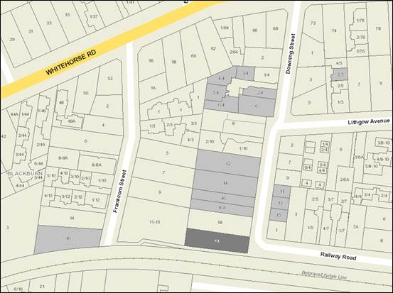
Subject site
|
|
15 Objector Properties
(1 objector not shown on map)
|
é
North
|
BACKGROUND
The plans originally submitted with
the application were not supported by Council’s Waste team as there was
insufficient space provided to enable a waste collection vehicle to access and
exit the site.
In response to concerns raised,
amended plans were submitted under Section 57(a) of the Planning and
Environment Act 1987 on 14 December, 2017 (and are the decision plans),
which responded to these concerns. The predominant alterations included
revising the layout to G.01 to allow for a passing area to be incorporated into
the access way for a waste collection vehicle.
The Site and Surrounds
The
subject site comprises one allotment located to the south-west corner of
Downing Street and Railway Road, abutting a public path and the railway line to
the south. The site is rectangular in shape with a frontage to Downing
Street of approximately 15.24 metres, a southern (side) boundary of
approximately 50.28 metres, a northern (side) boundary of approximately 57.96
metres, a rear boundary of approximately 16.34 metres and a total site area of
922.13m2.
The site
is occupied by a single storey weatherboard dwelling, set within an established
garden setting.
The land has a considerable fall
from Downing Street to the west of approximately 2 metres across the site and is
subject to flooding (as determined by both Council and Melbourne Water).
A 1.83 metre wide sewerage easement is located parallel to the rear
boundary.
The immediate context comprises:
South:
· Land
on the southern side of the railway line, approximately 40 metres away,
generally consists of single storey post-war dwellings located in a General
Residential Zone. This area transitions into a Neighbourhood Residential
Zone further to the south, approximately 150 metres from the subject site.
West:
· The
subject site abuts a consolidated lot (11-13 Frankcom Street) which contains a
double storey brick veneer dwelling. A planning permit (WH/2016/1172) was
issued in December 2017 after a Compulsory Conference at VCAT for Construction
of a residential apartment building comprising up to 35 dwellings.
· Within
the wider Frankcom Street location, there is evidence of multi-unit
developments, including 10, 12, and 14 Frankcom Street (5, 4, and 4 dwellings
respectively).
East:
· To
the east, at numbers 11, 13, 15 Downing Street, and 1 Railway Road are four (4)
– three (3) storey dwellings, approved by Council under planning permit
WH/2010/494.
· Further
along Railway Road there is evidence of multi-unit developments, including two
single storey dwellings located at number 5 Railway Road, and four single
storey dwellings located at number 7 Railway Road.
· Located
in the wider context is Blackburn railway station located approximately 300
metres east of the subject site. The immediate context surrounding the railway
station includes land zoned for commercial uses.
North:
· Whitehorse
Road, a major road, is located approximately 200 metres due north of the
subject site.
· Land
on the northern side of Whitehorse Road comprises a mix of higher and medium
density residential development. Elmhurst Basin, a public park available for
recreational purposes is located within this area.
Planning Controls
Zone:
The site is within the Residential Growth Zone Schedule 2
(RGZ). The purpose of Clause 32.07 (Residential Growth Zone) includes:
· To
implement the State Planning Policy Framework and the Local Planning Policy
Framework, including the Municipal Strategic Statement and local planning
policies.
· To
provide housing at increased densities in buildings up to and including four
storey buildings.
· To
encourage a diversity of housing types in locations offering good access to
services and transport including activity centres and town centres.
· To
encourage a scale of development that provides a transition between areas of
more intensive use and development and other residential areas.
· To
ensure residential development achieves design objectives specified in a
schedule to this zone.
· To
allow educational, recreational, religious, community and a limited range of
other non-residential uses to serve local community needs in appropriate
locations.
Pursuant to Clause 32.07-5 (RGZ), a
planning permit is required for the construction of two or more dwellings on a
lot. At the time this application was lodged the preferred maximum
building height was 14.5 metres that applies to dwellings and residential
buildings, as contained at Clause 32.07-7 (as there is a slope of the land of
2.5 degrees or greater). This is still applicable.
Overlay:
A Special Building Overlay (SBO – contained at Clause
44.05) which relates to urban areas liable to inundation by overland flows
affects a portion of the rear of the site. The overlay purpose states:
· To
implement the State Planning Policy Framework and the Local Planning Policy
Framework, including the Municipal Strategic Statement and local planning
policies.
· To
identify land in urban areas liable to inundation by overland flows from the
urban drainage system as determined by, or in consultation with, the floodplain
management authority.
· To
ensure that development maintains the free passage and temporary storage of
floodwaters, minimises flood damage, is compatible with the flood hazard and
local drainage conditions and will not cause any significant rise in flood
level or flow velocity.
· To
protect water quality in accordance with the provisions of relevant State
Environment Protection Policies, particularly in accordance with Clauses 33 and
35 of the State Environment Protection Policy (Waters of Victoria).
Pursuant to Clause 44.05-1 a
planning permit is required to construct a building, or to construct or carry
out works. The application was referred to Melbourne Water under Section 55 of
the Act.
Particular Provisions:
· Clause
52.06 (Car Parking) deals with a new use on site and deals with car parking
provision and design. No car parking reduction is being sought as part of
this application.
· Clause
52.34 (Bicycle Facilities) applies to residential developments of four or more
storeys and encourages cycling as a mode of transport through requiring the
provision of suitable bicycle facilities. The proposal provides
sufficient on site bicycle spaces.
· Clause
55 (Two or More Dwellings on a Lot and Residential Buildings) is applicable for
this application and contains 34 design Standards and Objections to be
satisfied.
PROPOSAL
The application seeks approval for
the development of the land for a four storey apartment building, plus two
basement car parking levels. The main pedestrian entrance is located with
a frontage, and vehicle access into the basement levels, via Downing
Street.
The proposal includes 19 dwellings,
with 12 dwellings containing two bedrooms, two dwellings containing one bedroom,
and five dwellings containing 3 bedrooms. The terraces at ground floor and
balconies at first, second, and third floors are north-facing. The ground floor
includes the lobby, gymnasium, and shared garden/BBQ area. The massing of the
building is generally uniform throughout each of the four levels.
The development contains 2 basement
levels comprising the sub floor area, store room, plant room, bin store, bike
store and car parking spaces.
Overall, the site coverage equates
to 63.68 per cent and the overall site permeability equates to 36.32 per cent.
Vehicle access and basement
levels
The proposal includes the following
components:
· The
existing vehicle crossovers will be widened to 3.5 metres and offers access via
a ramp to the basement car parking.
· 28
car parking spaces are provided within the basement levels.
· 25
resident car spaces are provided using a combination of the Klaus
‘Trendvario 4000’ and ‘Trendvario 4300’ stacker system.
The car stacker system is a semi-automatic system providing triple or double
height platforms.
· Three
visitor spaces are provided adjacent to the amenities store area.
· A
total of 12 bicycle spaces are provided as part of the proposal. Eight bicycle
parking spaces are provided adjacent to the visitor car spaces in the basement
and another 4 space are located on the pedestrian pathway from Downing Street.
· There
are 19 storage cages located in the sub-floor basement level, with lift access.
Landscaping
· The
proposal allows for small shrubs along a part of the southern boundary, and
almost the entire northern boundary, while providing more substantial
landscaping to the rear of the site, given the benefit of the basement level
setback from the rear boundary. A concept landscaping plan has been
submitted with the application.
General
· The
materials include various types of powder-coated metal cladding, timber eaves
cladding, brick, aluminium framed double-glazed windows, and render finish.
· Given
the slope of the land, the apartment building height varies between
approximately 12.7 metres (at the east elevation) and 14.15 metres (at the west
elevation).
· The
site coverage is 63.68 per cent with a permeability of 36.32 per cent.
CONSULTATION
Public Notice
The application was advertised by
mail to the adjacent and nearby property owners and occupiers and by erecting
notices to the Downing Street frontage. Following the advertising period
17 objections were received.
The issues raised are summarised as
follows:
· Out
of keeping with the neighbourhood character and VPO2.
· Loss
of landscape character and habitat for birds.
· Overshadowing
of neighbouring properties and gardens.
· Overlooking.
· Excessive
visual bulk and building height.
· Tree
removal and impacts to neighbouring trees.
· Insufficient
open space and landscaping provision.
· Tight
on-site vehicle movements.
· Steep
driveway ramp grades.
· Proposed
permeable paving is unsuitable for steep grades.
· Loss
of on-street parking.
· Increased
traffic and associated safety impacts.
· Increased
noise and light emissions.
· Drainage
and flooding impacts
· Negative
impact on property values
· Inaccuracies
on plans - permeability calculation and neighbouring addresses.
Consultation Forum
A Consultation Forum was held on 11
July 2017 and was chaired by Cr Massoud. Approximately 11 objectors
attended the meeting, along with planning officers and the permit applicant.
Whilst much discussion occurred with regard to the key areas of concern for
objectors, no resolution was reached, and consequently the objections remain.
Referrals
External
Melbourne Water
The application was referred to
Melbourne Water under Section 55 of the Act as required by the Special Building
Overlay. Melbourne Water granted approval of the application subject to
conditions on 1 June, 2017.
It is noted that the applicant has
provided Flood Storage Capacity Calculations which offer a demonstration of the
water storage capacity of the subject site, in both the existing and proposed
contexts. The calculations were submitted to Melbourne Water for approval which
demonstrates that the Sub-Floor level and rainwater tanks of the proposed
development will increase the capacity of water storage on site by
approximately 39,850 litres.
The conditions imposed by Melbourne
Water seek to ensure that the relevant finished floor/surface levels across the
site will not impede stormwater flows across property boundaries. The
applicable finished floor level of 83.61 to AHD is a conditional requirement
imposed by Melbourne Water to incorporate both the ground floor of the
dwellings and a flood proof apex at the entrance of the site. The sub floor
level includes permeable screens which allow water to flow across the site.
VicTrack
The application was referred to
VicTrack under Section 52 of the Act as the land is adjacent (no common
boundary) to a VicTrack railway line. VicTrack stated no objection to the
proposal.
Internal
Engineering and Environmental
Services Department
· Transport
Engineer
The Transport Unit support the
proposal, subject to the following comments/conditions:
Car Parking
|
Usage
|
Proposal
|
Planning Scheme Rate
|
Required Spaces
|
Spaces provided
|
|
Dwellings
|
|
|
|
|
|
1 & 2 bedroom dwellings
|
14
|
1 space per dwelling
|
14
|
15
|
|
3+ bedroom dwellings
|
5
|
2 spaces per dwelling
|
10
|
10
|
|
· Visitor
parking
|
|
1 space per 5 dwellings
|
3
|
3
|
|
|
Total spaces required
|
27
|
28
|
The proposal provides 28 car
parking spaces which meets the requirements of Clause 52.06 of the Whitehorse
Planning Scheme.
Traffic Generation
As detailed in the traffic impact
assessment report submitted by the applicant, it is unlikely that there will be
a significant impact upon the local road network or nearby intersections;
therefore there is no objection to the proposal based on traffic impact.
Recommendations
The following recommendations
relating to the development are made:
Parking Management Plan
· A
parking management plan needs to be submitted which will include allocating
parking spaces to individual properties, signing of parking spaces, line
marking of parking spaces and detail how access will be achieve by visitors
i.e. an intercom and how parking will be secured.
Car Parking Facilities
· The
plans state that it is proposed to use a Trendvario 4300 and 4000 Standard
Type. The Ratio report states that 1.8m of headroom will be provided in
the ground floor and in the pit, however the plans need to state this by
detailing the model i.e. Trendvario 4300 GT 200.
Ramp Grades and Width
· The ramp grade from the property line is to be modified so
that a maximum grade of 1:10 for the first 5m is provided as required by Clause
52.06-8 ‘Design Standard 3: Gradients’ of the Whitehorse Planning
Scheme. The proposed single lane ramp is to be widened to 3.6m as required by
Australian Standard AS 2890.1 figure 2.8.
Passing
Area
· The proposed ramp is approximately 30m long which requires
a passing area at the property line to reduce potential congestion on Downing
Street when vehicles are trying to pass each other. It is
recommended that the passing area should be 6m long by 6m wide which allows a
visitor intercom on a splitter island to be installed.
Head
Room
· Insufficient information has been provided to determine if
the required headroom has been provided. The designer is to submit a
longitudinal section of the circulation roadway showing the headroom provided
at the entry point and throughout the parking area demonstrating a minimum
vertical headroom of 2.2m.
Sight
distance
· It
is unclear as to whether the required sight distance at the property boundary
to pedestrians is provided. The maximum height of any structure or
foliage is 700mm within the area two (2) metres along the frontage road from
the edge of an exit lane and 2.5 metres along the exit lane from the frontage or
provide fifty percent (50%) clear of visual obstructions as required by Clause
52.06-08 of the planning scheme.
· Waste
Engineer
It is noted that Council’s
waste engineer originally objected to the proposal based on there being an
inadequate location for bin collection. However, the amended plans submitted
under Section 57(a) have included a passing area which allows the waste vehicle
to prop whilst the bins are collected; ensuring traffic is uninhibited along
the accessway. To achieve this without impacting upon residents within Downing
Street or future residents of the apartments, the front apartment has been
reconfigured and the frontage narrowed. Therefore, Council’s waste
engineer supports the proposal, subject to a number of conditions, including
the provision of a private waste collection.
· Assets
Engineer
Council’s asset engineer
supports the proposal, subject to standard conditions. It is noted that the
relevant flood authority for this site is Melbourne Water; whilst the Special
Building Overlay affects the rear portion of the lot, flood mapping from
Melbourne Water covers the entire subject site. .
Planning Arborist
Council’s planning arborist
supports the proposal, subject to a number of conditions requiring tree
protection areas to be designated on the plans, and tree protection fencing to be
provided. It is however noted that one tree has been identified by
Council’s arborist that has not been shown the plans; Tree 26.
This tree is not shown on the plans
and is located on the adjacent land to the south. It is positioned immediately
outside and adjacent to the south boundary fence of the subject site.
The proposal includes buildings and
works within a significant portion of the tree protection zone of this tree,
which means it could become unstable at ground level. If it was to fail at
ground level it could fall on the train tracks. To ensure the tree is not
adversely impacted, the plans must be amended to show no soil level changes
within 3.6m of the south boundary fence where within the TPZ of this tree.
Considering that the tree is not located
within the subject site a condition of permit, should one be granted, will
require the developer to obtain consent for the tree’s removal prior to
the construction of buildings and works.
It is noted that Council’s
Property and Rates Department confirmed that the land is designated as a road
on title, however is not registered as a road on Council’s Road Register.
ESD Advisor
Council’s ESD officer
supports the proposal, subject to conditions including an amended Sustainability
Management Plan (SMP).
DISCUSSION
Consistency with State Planning Policies
The strategic planning
directions in both State and Local Planning Policy Frameworks identify the
subject site as suitable for high density housing, which will widen housing
choice and make better use of existing infrastructure. The proposed
development achieves this overarching strategic objective to provide a greater
range and intensification of residential development. The site is within
walking distance of public transport (trains and buses) and parks, provides
direct access to the Blackburn Activity Centre and is within 2km of the Box
Hill Metropolitan Activity Centre.
The proposal complies with Clauses
10.04 (Integrated decision making) of the Whitehorse Planning Scheme. Clause
10.04 requires that planning/responsible authorities integrate the range of
policies and balance conflicting objectives of net community benefit. It is
considered that the proposal responds appropriately to economic, social, and
environmental factors by incorporating a proposal that will provide:
· A
development which will contribute to housing affordability within the
municipality; and
· A
site responsive design that will respect the surrounding environment without
affecting the amenity of the locality.
In accordance
with Plan Melbourne: Metropolitan Planning Strategy, Clause 11.06-2, Housing
Choice, includes the objective to provide a diversity of housing in defined
locations that cater for different households and are close to jobs and
services. Increasing housing supply near services and public transport is
encouraged to reduce the cost of living and facilitate the supply of affordable
housing.
Clause 15 Built
Environment and Heritage, identifies that planning should ensure all new land
use and development appropriately responds to valued built form and cultural
context.
Clause 16.01-2 Location of
Residential Development encourages new housing to be located in or close to
activity centres, employment corridors, services and transport. This is
to be achieved by increasing the proportion of housing in Metropolitan
Melbourne to be developed within the established urban area, to reduce the
pressure for fringe development. In addition, Clause 16.01-4, Housing
Diversity, recommends the provision of a range of housing types to meet
increasingly diverse needs by widening housing choice, particularly in the
middle and outer suburbs.
Clause 18 has objectives to
encourage higher land use densities and mixed use developments near the
Principal Public Transport Network. Pursuant to the State Transport
Policy, Clause 18.02-1 also promotes the use of sustainable personal transport,
including walking and cycling.
Clause 19.01 promotes renewable
energy use in development and Clause 19-03-05 seeks to minimise waste and
encourage recycling within new development.
Consistency with Local Planning
Policies
Clause 22.03,
Residential Development, identifies the site as being within a Substantial
Change area. This policy recommends that development is facilitated
within Substantial Change Areas as these have been identified as being able to
sustain higher density development based on environmental and infrastructure
considerations, and will make a significant contribution to increases in
housing stock. Apartment style building forms are encouraged within
Substantial Change Areas, however it is noted that buildings interfacing
sensitive areas should have a scale and massing appropriate to the character
and scale of their context, and higher density building forms should be located
away from sensitive interfaces.
The proposal is consistent with the
purpose of the Residential Growth Zone which seeks to provide housing at
increased densities, to encourage a diversity of housing types in locations
offering good access to services and transport, and to a transition of building
scales between areas of more intensive development and areas of restricted
housing growth. It is noted that the purpose also references building
forms up to four storeys.
The site is included within the
Garden Suburban Precinct 13. Substantial Change Areas within this
precinct, including the subject site, are expected to accommodate more
dwellings ‘with slightly more compact siting than the remaining
residential areas, but with space for large trees and gardens’.
It is considered that the site can accommodate a more robust built form than is
typically encouraged within the Substantial Change Areas of Garden Suburban
Precinct 13 due to the subject land’s context to the south (railway
line). The substantial setback proposed along the rear boundary affords
an opportunity for large canopy planting in accordance with the preferred
character statement under Garden Suburban Precinct 13. As landscaping areas
have been made available along the rear and east boundaries it is considered
appropriate to include conditions of permit that require additional planting to
enhance the tree coverage and landscape character (see discussion below).
Clause 22.04, Tree Conservation,
seeks to encourage the retention and regeneration of significant
vegetation. The development proposes the removal of 17 trees located
within the subject site which does not require
planning permission from the Responsible Authority. As identified within the
consultant arborist report the trees were given a rating of none, low, or
moderate. With regard to the acceptability of replanting, please refer to the
discussion below (under Standard B13).
The trees located on adjoining
properties will be protected via conditions of permit. Council’s
arborist has suggested that a tree root investigation and a Tree Management
Plan (TMP) written in accordance with AS4970-2009 be conditioned for Trees 1
and 2 on the subject site and Tree Group 20 on the adjoining property.
The proposal does provide space
within the front and rear of the site for landscaping and tree planting that
will serve to replace the trees being removed.
Clause 55 (ResCode)
Standard B8 (Site coverage)
It is noted that the overall site
coverage for the proposed development is 63.68% which is greater than the 60%
stated within Standard B8. Considering that the conditional approval from
Melbourne Water requires the development to achieve a minimum of 40% to be
maintained at natural surface levels, it is suggested that the total site
coverage (building envelope) be reduced to 60% to achieve compliance with both
Standard B8 and Melbourne Water. The reduction of 3.68% represents 33.92sqm
which will have to be reduced from the proposed building envelope.
Standard B13
(Landscaping)
Relevant
objective(s):
o To encourage
development that respects the landscape character of the neighbourhood.
o To encourage
development that maintains and enhances habitat for plants and animals in
locations of habitat importance.
o To provide appropriate
landscaping.
o To encourage the
retention of mature vegetation on the site
The Schedule 2 variation to the
standard under the Residential Growth Zone qualifies that [a landscape layout
and design should provide for]:
Provision of at least one canopy
tree that has the potential of reaching a minimum mature height of 8 metres.
The species of canopy tree should be native, preferably indigenous.
The applicant has provided a
landscape plan which includes the provision of 4 x 5 metre (h) canopy trees
(Japanese Maple) and 2 x 10 metre (h) advance canopy trees (Chinese Elm) to the
rear. In addition to the proposed vegetation, two existing canopy trees located
within the frontage are proposed to be retained (a 12(h) x 4(w) metre Bhutan
Cypress, and a 12(h) x 12(w) metre Eucalyptus nicolii). A preference for more
native and indigenous species will be reflected in any conditions for approval.
In considering the landscaping
layout of the proposed development it must be weighed against its zoning and
locational context, being in a Residential Growth Zone adjacent a railway line
(to the south). There is no typical ‘sensitive’ amenity interface
of existing residential properties to the south as this is a laneway/railway
interface; and as such the scale of built form anticipated along this boundary
can be more ‘intensive’ – and landscaping to soften built
form is less required.
In considering the northern
interface the context includes a residential dwelling with an area of secluded
private open space (SPOS) in the rear yard. The ground floors to Dwellings G.02
to G.05 propose private terraces within the SPOS areas and therefore limit the
opportunity for screen planting to soften the built form. It is noted that the
landscaping plan indicates that these spaces will be filled with Viburnums
‘Emerald Lustre’ which have a mature height of 4 metres. As such,
it is considered that a condition of permit (should one be granted) will
require the terraces reduced in size to accommodate the provision of one 6 metre
canopy tree in conjunction with the Viburnums proposed to enhance the
landscaping perspective along the northern boundary.
Further, it is considered that an
additional 10 metre canopy tree can be provided within the rear yard to soften
the western interface and contribute to the Garden Suburban preferred character
guidelines.
Standard B17
variation
Relevant
objective(s):
o “To
ensure that the height and setback of a building from a boundary respects the
existing or preferred neighbourhood character and limits the impact on the
amenity of existing dwellings.”
It is noted that the proposed
northern and southern wall setback distances are non-complaint with Standard
B17. The building wall height to the south is measured at 13.1 metres where
viewed from the east elevation (Downing Street) and therefore requires a
setback distance of 8.19 metres (whereas 2.2 metres is provided). It is noted
that this interface is adjacent to the railway line and consequently the
neighbourhood character context is divided between the north and south. As this
interface is to a non-sensitive railway and surrounding context (e.g. laneway)
it is considered an acceptable design response. The proposal does not impact
upon an existing dwelling’s sensitive amenity or cause detrimental overshadowing
of private open space. Given the context, the proposal variation sought is
acceptable.
The northern
setback includes a 12.7 metre maximum wall height which is setback between 3.7
to 4.9 and 6.6 (where inset) metres from the boundary. The 12.7 metre point
requires a setback distance of 7.79 metres at its maximum, thus is
non-compliant.
1.
In seeking to vary the Standard B17
requirement the relevant assessment criteria include the following:
Decision
guidelines (as relevant) listed within the Schedule 2 to the Residential Growth
Zone, being:
§ The potential impact on the amenity of existing adjoining
residential dwellings in the Residential Growth Zone.
Strategies for
Substantial Change Areas as listed within Clause 22.03 (Residential
Development), being:
§ Locate new development in the form of flats and apartments
in Substantial Change Areas only.
§ Provide a range of dwelling types, sizes and tenures,
including affordable housing, in larger developments.
§ Ensure buildings interfacing sensitive areas and uses have
a scale and massing appropriate to the character and scale of their context.
§ Create a new, higher density urban character in areas
located away from sensitive interfaces.
Building height
and form guidelines as listed within the Garden Suburban, Precinct 13 character
guidelines, being:
§ In Substantial Change Areas buildings should not exceed 4
storeys in height, unless otherwise specified in the current adopted structure
plan or urban design framework applying to the location.
Correspondence
during the course of the application raised a concern about the northern wall
(in a request for further information letter on 14 June, 2016) and stated the
following:
§ The height and length of the wall on the northern boundary
will have an unreasonable impact upon the amenity of the adjoining properties,
especially considering the scale of the development and lack of setbacks from
these boundaries.
In response to
Council’s initial concerns the applicant submitted amended plans which
included the alteration of the façade form (e.g. fenestrations,
treatment) and a substantial variation and addition of materials, including
brick enclosed within architectural feature elements (large rectangular rendered
sections). The images below include the northern elevation and the third floor
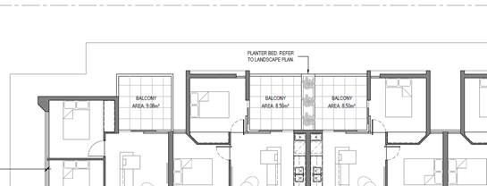
layout adjacent to the northern boundary. It can be seen from the third floor
layout that it provides an appropriate amount of articulation via insets of
form to create a staggered interface that allows a transition of setback
distances from the boundary. There are only three points (being the bedrooms)
which include the lesser setback distance, while the majority is either
balconies, or 4.9 metres or 6.6 metre insets. This creates a perception of the
built form being broken up rather than a dominating continuous mass.
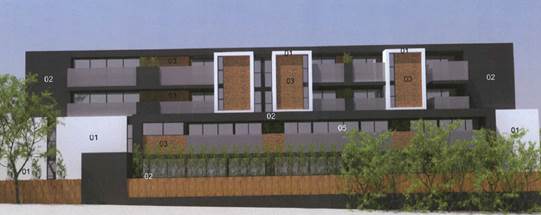
Figure
1 – Northern elevation (partial)
Figure
2 - Third floor layout (partial)
In reviewing the immediate context
to the north it includes a single storey dwelling with a rear SPOS area,
moderately vegetated. It is noted that number 18 Downing Street, the abutting
property, has not lodged an objection to the application with Council. Although
the setback distance is non-compliant it is not considered that the amenity of
the dwellings to the north is being compromised to a point that is
unreasonable. The orientation of the lot means that no solar access is
diminished from number 18 Downing Street, there are no overlooking impacts, and
vegetation is being protected. The relevant scope of assessment is therefore
limited to visual amenity, which as discussed above is being mitigated by the
variation of materials, fenestrations, and form articulation.
The Residential Growth Zone and the Garden Suburban –
Substantial Change Area envisage up to four storeys and consequently an
increase in height, bulk, and mass is anticipated. Therefore, on balance it is
considered that the proposed apartment building offers appropriate design
responses which will not unreasonably detract from the immediate existing
amenity of adjoining dwellings.
Standard B24 (Noise Impacts)
Relevant
objective(s):
“To
contain noise sources in developments that may affect existing
dwellings.”
“To
protect residents from external noise.”
Due to the
location of the development within close proximity to a railway line it is
considered that dwellings may be compromised by excessive noise associated with
trains. Therefore, all windows to the dwellings will require acoustic glazing. This will ensure that all rooms are protected from noise in
accordance with the objective of this clause.
Vehicle Access Arrangements and
Car Park Layout
A number of the objections raised
concern with the lack of appropriate on-site car parking for the
development. As set out above, the statutory car parking requirement is
27 spaces (24 resident spaces and 3 visitor spaces) which the proposal meets by
providing 28 spaces (25 resident spaces and 3 visitor spaces). Council’s
Transport Engineers support the above assessment.
Bicycle facilities
Bicycle parking requirements
applicable to the proposed development are specified in Clause 52.34. The
proposed development generates a requirement for 3 resident spaces and 1
visitor spaces. Within the ground level
car park is a bicycle compound containing 8 racks. The provision of 8
bike spaces exceeds the statutory requirement. There is a further rack of 4
spaces adjacent to the pedestrian walkway from Downing Street.
The proposed provision of bicycle
parking meets the Planning Scheme Requirements.
Public Transport Access
The site is well-serviced and
within convenient walking distance from Blackburn train station and bus
interchange.
Whitehorse Road itself has
substantial access to a number of main north-south metropolitan roads
including; Springvale Road, Blackburn Road and Eastlink.
Flooding, drainage, and the
Special Building Overlay
It is acknowledged that aside from
matters of neighbourhood character and built form, the most pressing issues for
objectors is that of flooding; specifically, the historic nature of floodwaters
within this section of Downing Street, and adjacent Frankcom Street. Objectors
have presented significant amounts of information including recent and historic
photos demonstrating the extent to which the subject site and the site
immediately to the west in Frankom Street have been flooded.
Officers acknowledge that the issue
of flooding is a relevant one, and as such have sought to thoroughly consider
and understand the impacts that this development may have. The subject site is
partially covered by a Special Building Overlay, which reflects the propensity
of the site to flood resulting from stormwater through the nearby Melbourne
Water drain.
The whole site however is not
covered by a flood overlay under the planning scheme.
From a statutory
perspective, Council’s Asset team have identified that the responsibility
for imposing the flood mapping is within the remit of Melbourne Water and as
such implementation of measures to ensure flooding is appropriately managed is
within their jurisdiction. Melbourne Water as previously identified, have
granted consent for the proposed development, having been provided with a full
set of plans for the development.
From a design perspective, the
proposed design has sought to implement a unique response through raising the
finished floor level, allowing for provision of a sub-floor with a permeable
barrier, and increasing the overall flood storage capacity. It is not
anticipated that there will be any detrimental flooding impacts associated with
the proposed development; this has also been accepted by Melbourne Water.
In considering the proposal against the requirements of the
Whitehorse Planning Scheme, the Special Building Overlay contains decision
guidelines at Clause 44.05-6 that must be considered. The guidelines are listed
below (as relevant):
· Any
comments from the relevant floodplain management authority.
· The
existing use and development of the land.
· Whether
the proposed use or development could be located on flood-free land or land
with a lesser flood hazard outside this overlay.
· The
susceptibility of the development to flooding and flood damage.
· Flood
risk factors to consider include:
o The
frequency, duration, extent, depth and velocity of flooding of the site and
access way.
o The
flood warning time available.
o The
danger to the occupants of the development, other floodplain residents and
emergency personnel if the site or access way is flooded.
· The
effect of the development on redirecting or obstructing floodwater, stormwater
or drainage water and the effect of the development on reducing flood storage
and increasing flood levels and flow velocities.
In response to these decision guidelines, the relevant
floodplain management authority is Melbourne Water who has provided consent for
the proposed development. The development, whilst not able to locate on flood
free land, has sought to provide a unique response in recognition of the unique
and challenging context of the site.
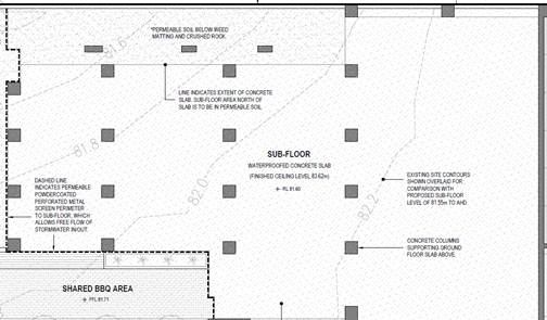
Further, it is noted that appropriate construction techniques
have been incorporated into the design, including creation of a Sub-floor
(image below) into the design to allow retention of floodwaters beneath the
applicable 1:100 year flood level provided by Melbourne Water.
The sub-floor concrete finished ceiling level is 83.62m and
includes permeable metal screens to its periphery to allow unimpeded flows
across the subject site. Therefore, in response to the
‘obstructing/redirecting’ flows decision guidelines it is
considered that the proposed building will have minimal implications on this.
With regard to
the overflow pipe it is noted that this is located outside the subject site and
is a separate issue to the consideration of this planning application. The
flooding and drainage issues associated with the broader street network,
Council and Melbourne Water drainage assets, are for consideration outside the
scope of this planning application and will need to be appropriately managed to
meet all necessary statutory requirements.
Objectors Concerns not
Previously Addressed
· Represents unacceptable and excessive loss
of established vegetation and impact on wildlife habitats
Response: The
subject site does not have a significant landscape overlay, environmental
significance overlay or vegetation protection overlay, all of which would
restrict the removal of vegetation and/or identify strategic bio-diverse
locations. It is considered that the proposed landscaping will contribute to
the vegetative character of the area and whilst existing vegetation on site is
proposed to be removed, it is considered an acceptable outcome when balanced
against the other objectives of the State and Local Planning Policy Framework.
· The building of apartments will
significantly alter the demographic of the area
Response: This is not a matter that can be
considered as part of a planning application and therefore cannot be assessed
as part of this report.
· Not safe for children to walk on the
pavement
Response: The issue of pedestrian safety
has not been raised by Council’s Transport unit.
· Does not meet the objectives of the
Special Building Overlay; and
· The drain connected to the overflow pipe
located at the end of the road is ineffective
Response: The proposal has been appropriately
considered against the applicable planning controls as discussed in detail
previously in this report. The assessment of the existing flooding issues
outlines how these have been mitigated through the design response, whilst
ensuring this design response does not defer floodwaters into surrounding
properties. Council’s Assets team, as well as Melbourne Water and the
applicant’s consultant engineer are satisfied with the response to
flooding on this and surrounding properties.
· Removal of two Magenta Cherry trees
location on the land
Response: An
objector stated that the Magenta Cherry tree is listed as vulnerable under the Commonwealth
Environment Protection and Biodiversity Conservation Act 1999 and therefore
should be protected. It is noted that the subject site is not affected by
any tree protection overlays (such as a Significant Landscape Overlay or
Vegetation Protection Overlay) and therefore the planning scheme does not
afford any protection to these trees at either a State or local policy
level. Nevertheless, review of the status of this species under the EPBC
Act confirms it as vulnerable; however there is no approved conservation advice
for the Magenta Cherry,
· Overlooking/Privacy
Response: The
proposed elevations demonstrate screening to all balconies and habitable room
windows, which would comply with the requirements of Standard B22
(Overlooking). However, the dimensions have not been stated on the submitted
plans and as such a condition of permit, should one be granted, will require
the plans be amended to include 1.7 metre high screens to all windows/balconies
with the potential for overlooking.
· Traffic
congestion/car parking
Response: The
objectors are essentially concerned with the impact of the new development in
relation to vehicles, traffic, nearby bus stop/route and parking locations. The
proposed development satisfies the requirements pursuant to Clause 52.06 as
each dwelling has one or two associated car parking spaces and it cannot be
assumed that the new residents will park their vehicles on the street or in a
location which would prejudice the amenity of the objector’s property,
disrupt the bus route and/or further congest the street. It is further noted
that local laws prohibit the parking of vehicles on nature strips.
· Noise
Response: The
proposed development is for a residential land use in a residential area and
there are not anticipated to be any associated noise impacts beyond what is
normally expected for dwellings.
CONCLUSION
The proposed construction of a four
storey apartment building is considered to be generally consistent with the
relevant provisions contained within the Whitehorse Planning Scheme, including
the State and Local Planning Policies, the Residential Growth Zone Schedule 2,
the Special Building Overlay, and Clause 52.06 Car Parking. The proposal
is considered appropriate as it responds to the broader strategic direction of
the SPPF through the appropriate location of housing stock in close proximity
to community and transport infrastructure, and satisfies Council’s LPPF
by offering a responsive sustainable design which includes predominantly
northern solar orientation, retention of some existing vegetation, the
opportunity for future canopy tree planting, and diversity of housing:
· This
report identifies the issues relevant to consideration of the proposed
development and concludes that the proposal, subject to conditions, addresses
the requirements of the Whitehorse Planning Scheme.
A total of 17 objections
from 16 properties were received as a result of public notice and all of the
issues raised have been discussed in this report.
It is recommended that the proposal
be supported.
Attachment
1 Decision
Plans ⇨ 
Ordinary Council Meeting 29
January 2018
9.1.2 739-743
Highbury Road, VERMONT SOUTH (Lot 2 LP 28492) Use & development of part of
the land for a childcare centre, the removal of vegetation under Clause 52.17
and the Vegetation Protection Overlay, and alteration of access to a road in a
Road Zone, Category 1
FILE NUMBER: WH/2017/414
ATTACHMENT
SUMMARY
This application was advertised,
and a total of 25 objections were received. The objections predominantly raised
issues with traffic congestion, on-street parking, access, noise, and
vegetation. A Consultation Forum was held on 28 November 2017 chaired
by Councillor Bennett, at which the issues were explored, however no resolution
was reached between the parties. This report assesses the application against
the relevant provisions of the Whitehorse Planning Scheme, as well as the
objector concerns. It is recommended that the application be supported,
subject to conditions.
|
RECOMMENDATION
That Council:
A Being the Responsible Authority, having
caused Application WH/2017/414 for 739-743 Highbury Road, VERMONT SOUTH (Lot
2 LP 28492) to be advertised and having received and noted the objections is
of the opinion that the granting of a Planning Permit for the use and
development of part of the land for a childcare centre, the removal of
vegetation under Clause 52.17 and the Vegetation Protection Overlay, and
alteration of access to a road in a Road Zone, Category 1 is acceptable and
should not unreasonably impact the amenity of adjacent properties.
B Issue a Notice of Decision to Grant a
Permit under the Whitehorse Planning Scheme to the land described as 739-743
Highbury Road, VERMONT SOUTH (Lot 2 LP 28492) for the use and development of
part of the land for a childcare centre, the removal of vegetation under
Clause 52.17 and the Vegetation Protection Overlay, and alteration of access
to a road in a Road Zone, Category 1, subject to the following conditions:
1. Before
the use and development starts, or any trees or vegetation removed, amended
plans (three copies in A1 size and one copy reduced to A3 size) shall be
submitted to and approved by the Responsible Authority. The plans must be
drawn to 1:100 scale, with dimensions, and be generally in accordance with
the plans submitted with the application but modified to show:
a) A total of 110 children places, inclusive of
a maximum of 44 children places at first floor.
b) All
barrier heights increased to 1.7 metres above finished floor level and be of a non-transparent material to restrict overlooking, for all outdoor play areas within 9 metres of adjoining
properties’ private open space or habitable room window areas.
c) Any
window sill heights increased to 1.7 metres above finished floor level where
within 9 metres of adjoining properties’ private open space areas.
d) Any alterations as required by the revised
WMP (Condition 10).
e) Wheel stops adjacent to the Highbury Road
boundary to prevent overhang of vehicles on landscaping and prevent vehicles
rolling onto the verge.
f) Wheel stops where adjacent to the
proposed building to prevent rolling.
g) Provision of the acoustic fence as per the
acoustic report provided with the application, to be freestanding within the
boundary of the subject site, and not attached to the existing fence.
h) Landscape Plan in accordance with Condition
3, including the following:
i. Four canopy trees capable of growing in
excess of 10 metres within the frontage.
ii. Two canopy trees capable of growing in
excess of 10 metres in the rear play space.
iii. All new trees must be planted at a minimum height
of 1.5 metres.
i) All sustainability features indicated
in the submitted, amended and approved Sustainability Management Plan (SMP).
Where features cannot be visually shown, include a notes table providing
details of the requirements (i.e. energy and water efficiency ratings for
heating/cooling systems and plumbing fixtures, etc.). At a minimum the plans
must include:
i. Design measures as identified in the
BESS Report, as required to legitimately exceed an overall score 50% and
exceed the ‘pass’ marks in the categories of Water, Energy
Stormwater and IEQ (indoor environment quality).
ii. Water-sensitive urban design measures as
required to achieve a STORM Rating of at least 100% or equivalent, including
a rainwater tank capacity of at least 25,000 litres, plumbed to all toilets,
irrigation and bin area wash down, as well as indicative pump and maintenance
access, and cross section details of rain garden, grass buffer and permeable
paving.
iii. Include arrows on stormwater plan, describing
indicative flow paths.
iv. Indicative
locations for all exterior building services equipment, i.e. utility meters,
condensers, hot water units, etc.
v. All operable windows, doors, winter garden
openings & vents in elevation drawings.
vi. Shadows as per actual sun angles on all elevation
drawings.
vii. Exterior shading for all east, north and west windows
greater than 1.5 square metres, to shade at least 35% from 11am to 3pm in
summer.
viii. Consistency between
the architectural and landscape drawings, regarding general planter areas,
tree size & locations.
ix. At least 2
operable openings for each childcare space tenancy. One of these may be a
door with access to outside, while the second may be a smaller operable vent
or operable, preferably spaced further apart.
x. Include
an annotation of the indicative timber species intended for use as decking or
cladding and other outdoor timber.
j) A notation stating that access between
Tracey Drive and the subject site must be restricted to allow access only by
residents of the site.
All of
the above must be to the satisfaction of the Responsible Authority. Once
approved these plans become the endorsed plans of this permit.
2.
The layout of the site and the size, design
and location of the buildings and works permitted must always accord with the
endorsed plan and must not be altered or modified without the further written
consent of the Responsible Authority.
3. No
building or works must be commenced (and no trees or vegetation shall be
removed) until a landscape plan prepared by a suitably qualified and
experienced person or firm has been submitted to and endorsed by the
Responsible Authority. This plan when endorsed shall form part of this
permit. This plan shall show:
a) A survey of all existing vegetation, abutting
street trees, natural features and vegetation.
b) Buildings, outbuildings and trees in
neighbouring lots that would affect the landscape design.
c) Planting within and around the perimeter of
the site comprising trees and shrubs capable of:
i. Providing a complete garden scheme,
ii. Softening the building bulk,
iv. Providing some upper canopy for landscape
perspective,
d) A schedule of the botanical name of all trees
and shrubs proposed to be retained and those to be removed incorporating any
relevant requirements of condition No. 1.
e) The proposed design features such as paths,
paving, lawn and mulch.
f) A planting schedule of all proposed
vegetation (trees, shrubs and ground covers) which includes, botanical names,
common names, pot size, mature size and total quantities of each plant.
Landscaping
in accordance with this approved plan and schedule shall be completed before
the addition to the building is occupied.
Once
approved these plans become the endorsed plans of this permit.
4. The
garden areas shown on the endorsed plan must only be used as gardens and must
be maintained in a proper, tidy and healthy condition to the satisfaction of
the Responsible Authority. Should any tree or shrub be removed or
destroyed it may be required to be replaced by a tree or shrub of similar
size and variety.
5. Prior
to the occupation of the development, all boundary walls must be constructed,
cleaned and finished to the satisfaction of the Responsible Authority.
6. Unless
with the prior written consent of the Responsible Authority, the hours of
operation are:
a) Monday to Friday - 7:00am to 6:00pm.
7. Unless
with the prior written consent of the Responsible Authority, the permitted
number of children at the centre at any one time is 110.
8. Unless
with the prior written consent of the Responsible Authority, the loading and
unloading of any goods or materials must only be during the hours between
10:00am to 2:30pm (Monday to Friday).
9. Prior
to the commencement of buildings or works on the land, a Construction
Management Plan, detailing how the owner will manage the environmental and
construction issues associated with the development, must be submitted to and
approved by Council.
The
Construction Management Plan must be prepared and managed by a suitably
qualified person who is experienced in preparing Construction Management
Plans in accordance with the City of Whitehorse Construction Management Plan
Guidelines.
When
approved the Construction Management Plan will form part of this permit and
must be complied with, to the satisfaction of the Responsible Authority, to
the extent that this is in the control of the owner of the land. The owner of
the land is to be responsible for all costs associated with the works to be
undertaken in accordance with the requirements of the Construction Management
Plan.
10. Prior to the
commencement of any buildings or demolition works, an amended Waste
Management Plan (WMP) must be submitted to and approved by the Responsible
Authority. This WMP must be generally in accordance with the SMP submitted
with the application, but amended to include the following changes:
a) Collection vehicles to exit the subject site
using the service road adjacent to Highbury Road and not Tracey Drive.
b) Relocation of the bin storage area adjacent
to car parking space 11 (the bin storage area must not be located within
greater than 10% of a TPZ of any proposed trees).
The
management of waste must always be in accordance with the Waste Management
Plan submitted by OneMileGrid (Reference: 170300WMP001B-F) or any subsequent
or amended version. The Waste Management Plan must be implemented to the
satisfaction of the Responsible Authority.
11. Prior to the
commencement of any buildings or demolition works, an amended Sustainability
Management Plan (SMP) must be submitted to and approved by the Responsible
Authority. This SMP must be generally in accordance with the SMP submitted
with the application, but amended to include the following changes:
a) A
STORM Rating Report with legitimate a score of at least 100% or equivalent,
including but not limited to rainwater harvesting with reuse, rain gardens
and grass buffers.
b) A complete, published BESS Report, with an
overall score that legitimately exceeds 50% and exceed the ‘pass’
marks in the categories of Water, Energy Stormwater and IEQ (indoor
environment quality).
c) In
order to substantiate Energy score, provide preliminary specifications on how
the proposed development is to achieve the Energy Deemed-to-Satisfy criteria.
This includes exterior wall insulation, glazing specification values, heating
and cooling systems, and hot water systems.
d) Control car park lighting (at least 50% of
lighting fixtures) with motion sensors
e) Commit to diverting at least 80% of
construction/demolition waste from landfill.
f) Submit a water balance calculation
justifying the rainwater tank capacity, based on long-term average rainfall
data, collection areas and expected end uses, which is in compliance with the
AS6400 standard of 1 full- and 4 half-flushes per person per day (giving 16.5
L/person/day for 4 star WELS rated toilet). A new rainwater tank size should
be selected based on the revised calculations, ensuring adequate reliability
of supply is maintained. Alternately, increase the size of the rainwater tank
to 26kL, which would enable a longer period of water security.
g) Connect the rainwater tanks to all toilet
flushing, irrigation and bin area wash-down.
All to the satisfaction of the Responsible Authority
12. Before
occupation of the development hereby permitted, areas set aside for parking
vehicles, access lanes and paths as shown on the endorsed plans must be:
a) Constructed to the satisfaction of the
Responsible Authority.
b) Properly formed to such levels that they can
be used in accordance with the plans.
c) Surfaced with an all-weather sealcoat to the
satisfaction of the Responsible Authority.
d) Drained to the satisfaction of the
Responsible Authority.
e) Line-marked to indicate each car space, all
access lanes and, if necessary, the direction in which vehicles are to travel
to the satisfaction of the Responsible Authority.
f) In accordance with any Council adopted
guidelines for the construction of car parks.
g) Parking areas and access lanes must be kept
available for these purposes at all times and maintained to the satisfaction
of the Responsible Authority.
13. The loading
and unloading of goods from vehicles must only be carried out within the
boundaries of the site or a dedicated loading bay and must not affect the
function of adjacent roads.
14. The amenity
of the area shall not be detrimentally affected by the use or development,
through:
a) Transportation of materials, goods or
commodities to or from the land,
b) Appearance of any building, works or
materials,
c) Emission of noise, artificial light,
vibration, smell, fumes, smoke, vapour, steam, soot
ash, dust, waste water, waste products, grit or oil,
d) Presence of vermin,
e) In any other way.
15. Alarms must
be directly connected to a security service and must not produce noise beyond
the premises.
16. All
stormwater drains and on-site detention systems are to be connected to the
legal point of discharge to the satisfaction of the Responsible Authority
prior to the occupation of the building/s. The requirement for on- site
detention will be noted on your stormwater point of discharge report, or it
might be required as part of the civil plans approval.
17. Detailed
stormwater drainage and/or civil design for the proposed development are to
be prepared by a suitably qualified civil engineer and submitted to the
Responsible Authority for approval prior to occupation of the
development. Plans and calculations are to be submitted with the
application with all levels to Australian Height Datum (AHD). All
documentation is to be signed by the qualified civil engineer.
18. Stormwater
that could adversely affect any adjacent land shall not be discharged from
the subject site onto the surface of the adjacent land.
19. Prior to
works commencing the Applicant/Owner is to submit design plans for all
proposed engineering works external to the site. The plans are to be
submitted as separate engineering drawings for assessment by the Responsible
Authority.
20. The
Applicant/Owner is responsible to pay for all costs associated with
reinstatement and/or alterations to Council or other Public Authority assets
as a result of the development. The Applicant/Owner is responsible to
obtain all relevant permits and consents from Council at least 7 days prior
to the commencement of any works on the land and is to obtain prior specific
written approval for any works involving the alteration of Council or other
Public Authority assets. Adequate protection is to be provided to
Council’s infrastructure prior to works commencing and during the
construction process.
21. The
qualified civil engineer when undertaking civil design must ensure that the
landscape plan/s and drainage plan/s are compatible. The stormwater
drainage and on site detention system must be located outside the tree
protection zone (TPZ) of any trees to be retained.
22. Prior to the
commencement of construction, offset requirements in accordance with the
‘Permitted clearing of native vegetation – Biodiversity
assessment guidelines (Department of Environment and Primary Industries,
September 2013)’ must be completed to the satisfaction of the
Responsible Authority.
23. Documentation
proof providing the details that the offset has been satisfied must be
provided to Council prior to the commencement of the development or tree
removal.
24. Prior to felling, trees
identified for removal/felling must be examined (by a qualified zoologist)
for the presence of fauna, including those using external nests (e.g. Common
Ringtail Possums, bird nests) and tree hollows. If native fauna species are
located, they are to be salvaged and relocated in accordance with all
relevant legislation and approvals further to consultation with the
Department of Sustainability and Environment.
25. This permit will
expire if one of the following circumstances applies:
a) The development is not commenced within two
(2) years from the date of issue of this permit;
b) The development is not completed within four
(4) years from the date of this permit.
c) The use does not commence within six (6)
months of the completion of the development.
The
Responsible Authority may extend the periods referred to if a request is made
in writing pursuant to the provisions of Section 69 of the Planning and
Environment Act 1987.
PERMIT
NOTES
A. The design and construction of letterboxes
is to accord with Australian Standard AS-NZ 4253-1994.
B. The lot/unit numbers on the
“Endorsed Plan” are not to be used as the official street address
of the property. All street addressing enquiries can be made by contacting
our Property Team on 9262 6470.
Asset
Engineering
C. The design and construction
of the stormwater drainage system up to the point of discharge from an
allotment is to be approved by the appointed Building Surveyor. That includes
the design and construction of any required stormwater on-site detention
system. The Applicant/Owner is to submit certification of the design of any
required on-site detention system from a registered consulting engineer (who
is listed on the Engineers Australia National Professional Engineer Register
or approved equivalent) to Council as part of the civil plans approval
process.
D. The requirement for on- site
detention will be noted on your stormwater point of discharge report, or it
might be required as part of the civil plans approval.
E. All proposed changes to the
vehicle crossing are to be constructed in accordance with the submitted
details, Whitehorse Council’s – Vehicle Crossing General
Specifications and standard drawings
F. Report and consent – Any
proposed building over the easement is to be approved by the Responsible
Authority prior to approval of the building permit. If Report and Consent
contradicts with the Planning Permit, amendment of the Planning Permit might
be required.
G. The Applicant/Owner is to
accurately survey and identify on the design plans all assets in public land
that may be impacted by the proposed development. The assets may include all
public authority services (i.e. gas, water, sewer, electricity, telephone, traffic
signals etc.) and the location of street trees or vegetation. If any changes
are proposed to these assets then the evidence of the approval is to be
submitted to Council and all works are to be funded by the
Applicant/Owner. This includes any modifications to the road reserve,
including footpath, naturestrip and kerb and channel.
H. The Applicant/Owner must
obtain a certificate of hydraulic compliance from a suitably qualified civil
engineer to confirm that the on-site detention works have been constructed in
accordance with the approved plans, prior to Statement of Compliance is
issued.
I. There is to be no
change to the levels of the public land, including the road reserve or other
Council property as a result of the development, without the prior approval
of Council. All requirements for access for all-abilities (Disability
Discrimination Access) are to be resolved within the site and not in public
land.
J. No fire hydrants that
are servicing the property are to be placed in the road reserve, outside the
property boundary, without the approval of the Relevant Authority. If
approval obtained, the property owner is required to enter into a S173
Agreement with Council that requires the property owner to maintain the fire
hydrant”
C Has made this decision having particular regard to the
requirements of Sections 58, 59, 60 and 61 of the Planning and Environment
Act 1987.
|
MELWAYS REFERENCE 62 E9
|
Applicant: Auswell
Building Design & Consulting
Zoning: Neighbourhood
Residential Zone, Schedule 5 (NRZ5)
Overlays: Vegetation
Protection Overlay, Schedule 3 (VPO3)
Relevant Clauses:
Clause 11 Settlement
Clause 12 Environment
and Landscape Values
Clause 15 Built
Environment and Heritage
Clause 21.05 Environment
Clause 22.04 Tree
Conservation
Clause 22.05 Non-Residential
Uses in Residential Areas
Clause 32.09 Neighbourhood
Residential Zone
Clause 42.02 Vegetation
Protection Overlay
Clause 52.06 Car
Parking
Clause 52.07 Loading
and Unloading of Vehicles
Clause 52.17 Native
Vegetation
Clause 52.29 Land
Adjacent to a Road Zone, Category 1
Clause 52.34 Bicycle
Facilities
Clause 65 Decision
Guidelines
Ward: Morack
|
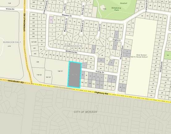
|
|
|
Subject site
|
|
25 Objector Properties
(5 outside of map)
|
é
North
|
BACKGROUND
History
No recent, relevant planning
applications are noted.
The Site and Surrounds
The site is generally rectangular
in shape with a frontage of 57.91 metres, an average depth of approximately
118.56 metres, and an overall site area of 6,826 square metres. A 1.83 metre
wide drainage easement is located parallel to the eastern boundary. A 1.83
metre wide drainage and sewerage easement is located parallel to the northern
boundary.
The land is
sitting approximately 3m higher than Highbury Road and slopes from the south‐west corner towards
the north‐east
corner approximately 5m. There is a single storey dwelling and a detached
‘summer house’ with a tennis court located in the rear portion of
the land. The land can be accessed both via Highbury Road from the south and
Tracey Drive from the north‐east.
The subject
site contains a considerable amount of vegetation, including canopy trees
situated along the frontage of the subject land. The remaining vegetation is
generally scattered throughout the remainder of the site, including to the
periphery.
The wider context comprises
predominantly residential land use, particularly noting that the immediate
context to the north and east contains typical single and double storey
detached dwellings set within rear open yards. The residential property
to the west is a very large parcel of land with an extensive garden area and a
residential dwelling located approximately 80 metres to the west. Land to the
south of Highbury Road consists of residential properties within the City of
Monash’s municipality.
Land located approximately 235
metres to the west of the subject site contains the Baptist Union of Victoria
Church (Crossways Church), which is situated within a Commercial 1 Zone.
Billabong Park, an area for recreation, including the provision of baseball
fields, is located approximately 240 metres to the north-east.
Planning Controls
Zone:
The site is within the
Neighbourhood Residential Zone Schedule 5 (NRZ5). The purpose of Clause
32.09 (Neighbourhood Residential Zone) includes:
· To
implement the State Planning Policy Framework and the Local Planning Policy
Framework, including the Municipal Strategic Statement and local planning
policies.
· To
recognise areas of predominantly single and double storey residential
development.
· To
manage and ensure that development respects the identified neighbourhood
character, heritage, environmental or landscape characteristics.
· To
allow educational, recreational, religious, community and a limited range of
other non-residential uses to serve local community needs in appropriate
locations.
A planning permit is required for
use of the land for a Child care centre pursuant to Clause 32.09-2 (Table of
uses). It is noted that as the use is not listed within the table it
automatically becomes a Section 2 – permit required use.
A planning permit is required for
the construction of buildings and works associated with a Section 2 use
pursuant to Clause 32.09-8.
Overlay:
A Vegetation Protection Overlay, Schedule 3 (VPO3 –
contained at Clause 42.02) affects the subject site, which relates to
Council’s Significant Tree Study (2006), and identifies significant
vegetation to be protected, and as the purpose states:
· To
implement the State Planning Policy Framework and the Local Planning Policy
Framework, including the Municipal Strategic Statement and local planning
policies.
· To
protect areas of significant vegetation.
· To
ensure that development minimises loss of vegetation.
· To
preserve existing trees and other vegetation.
· To
recognise vegetation protection areas as locations of special significance,
natural beauty, interest and importance.
· To
maintain and enhance habitat and habitat corridors for indigenous fauna.
· To
encourage the regeneration of native vegetation.
Pursuant to Clause 42.02-2 a planning permit is required to
remove, destroy or lop vegetation. The Schedule 3 to the this Overlay does not
exempt this requirement as the trees are identified within Incorporated
Document No. 11 – City of Whitehorse – Statements of Tree
Significance, 2006.
Clause 52.06 – Car Parking
Clause 52.06 applies to:
· A
new use; or
· An
increase in the floor area or site area of an existing use; or
· An
increase to an existing use by the measure specified in Column C of Table 1 in
Clause 52.06-5 for that use.
The purpose of Clause 52.06 includes:
· To
ensure that car parking is provided in accordance with the State Planning
Policy Framework and Local Planning Policy Framework.
· To
ensure the provision of an appropriate number of car parking spaces having
regard to the demand likely to be generated, the activities on the land and the
nature of the locality.
· To
support sustainable transport alternatives to the motor car.
· To
promote the efficient use of car parking spaces through the consolidation of
car parking facilities.
· To
ensure that car parking does not adversely affect the amenity of the locality.
· To
ensure that the design and location of car parking is of a high standard,
creates a safe environment for users and enables easy and efficient use.
The planning scheme requires 0.22
parking spaces per child to be provided for a child care centre. This equates
to a requirement for 24 car parking spaces.
The proposal is not seeking a
reduction in the car parking rate and therefore no permit is required under
this clause.
Clause 52.07 – Loading and
Unloading of vehicles
The purpose of this clause is:
· To
set aside land for loading and unloading commercial vehicles to prevent loss of
amenity and adverse effect on traffic flow and road safety.
No building or works may be
constructed for the manufacture, servicing, storage or sale of goods or
materials unless:
· Space
is provided on the land for loading and unloading vehicles as specified in the
table below.
· The
driveway to the loading bay is at least 3.6 metres wide. If a driveway changes
direction or intersects another driveway, the internal radius at the change of
direction or intersection must be at least 6 metres.
· The
road that provides access to the loading bay is at least 3.6 metres wide.
It is noted that no planning permit
is required for the waiver or reduction of loading as the child care centre is
not manufacturing, servicing, storing or selling goods or materials from the
land. However, it is noted that a condition of permit, should one be granted,
will require the loading/unloading of goods to be in between peak periods, i.e.
from 10am to 2:30pm.
Clause 52.17 – Native
Vegetation
It is noted that an amendment to
the planning scheme under VC138 was gazetted into the scheme on 12 December,
2017 which included transitional provisions for any applications to remove,
lop, or destroy native vegetation (contained at Clause 52.17-6). As the
application was lodged with Council prior to this date the scope of Clause
52.17 is considered under the previous policy controls. As such, the following
is based on Clause 52.17 policy prior to 12 December, 2017.
The purpose of this clause is:
· To
ensure permitted clearing of native vegetation results in no net loss in the
contribution made by native vegetation to Victoria’s biodiversity. This
is achieved through the following approach:
o Avoid the removal of
native vegetation that makes a significant contribution to Victoria’s
biodiversity.
o Minimise impacts on
Victoria’s biodiversity from the removal of native vegetation.
o Where native vegetation
is permitted to be removed, ensure that an offset is provided in a manner that
makes a contribution to Victoria’s biodiversity that is equivalent to the
contribution made by the native vegetation to be removed.
· To
manage native vegetation to minimise land and water degradation.
· To
manage native vegetation near buildings to reduce the threat to life and
property from bushfire.
Clause 52.17-2 notes that a permit
is required to remove, destroy or lop native vegetation, including dead native
vegetation.
Class of application
An application to remove, destroy
or lop native vegetation must be classified as one of the following risk-based
pathways: low, moderate or high, as defined in the Permitted clearing of native
vegetation – Biodiversity assessment guidelines (Department of
Environment and Primary Industries, September 2013). The application
requirements and decision guidelines included in this clause must be applied in
accordance with the classified pathway.
It is noted that the identified
pathway is ‘low’.
Offset requirements
Clause 52.17-6 contains the policy
for offsets:
The biodiversity impacts of the
removal of native vegetation are required to be offset, in accordance with the
Permitted clearing of native vegetation – Biodiversity assessment
guidelines (Department of Environment and Primary Industries, September 2013).
The conditions on the permit for the removal of native vegetation must specify
this offset requirement. The offset requirements must take account of:
· The
location of the native vegetation to be removed.
· The
condition and extent of native vegetation to be removed.
· The
strategic biodiversity score of the native vegetation to be removed.
· Whether
the native vegetation to be removed is important habitat for rare or threatened
species, and the proportional impact of the removal on those species’
habitat.
Referral
The
application does not require a referral to the Department of Environment, Land,
Water and Planning as per Clause 66.02-2 (native vegetation). A referral of an
application to remove native vegetation only applies if the application is one
of the following:
- To
remove, destroy or lop native vegetation if the area to be cleared is 0.5
hectare or more.
- To
remove, destroy or lop native vegetation for the following class of application
based on the risk-based pathway as defined in the Permitted clearing of native
vegetation – Biodiversity assessment guidelines (Department of Environment,
and Primary Industries, September 2013).
The area of native vegetation to be
cleared is less than 0.5 hectare and the identified pathway is
‘low’, therefore no referral is required.
PROPOSAL
Use:
It is proposed to utilise the
vacant front portion of the site as a child care centre. The proposed child
care centre will offer a maximum of one hundred and ten (110) places. It is
noted that the architectural plans and traffic assessment report show the total
number of the childcare centre to be 107 places which is incorrect.
The child care centre will utilise
the existing entry from Highbury Road and exit via the service road from
Highbury Road to the east. A total of 26 car spaces are provided on site: 22 of
the car spaces will be within the frontage of Highbury Road.
Staff:
The proposed childcare centre will
have a maximum of 16 staff with potential 2 contractors if needed.
Proposed
hours of operation:
The proposed childcare centre is to
operate during weekdays: Monday – Friday: 7am to 6pm.
Development:
The existing
dwelling with the detached ‘summer house’ and tennis court located
in the northern half of the subject site will be retained. The proposed
childcare centre will be constructed within the existing front garden area. The
proposed childcare centre is characterised by a contemporary design and
utilises a mixture of building materials, including different colour rendered
walls, timber, and weatherboard claddings.
The proposed
building will be partially three storeys with pitched roof form. The proposed
front setback to Highbury Road is 19.881m. A minimum 6m setback is provided to
the eastern boundary and approximately 19.5m setback is provided to the western
boundary.
The proposed
overall height (at the apex of the roof) is 11.91 metres. The total building
coverage is approximately 16.3% of the total site.
The building
details are:
Ground Floor
Level:
· A
secure entry foyer accessed directly form the pedestrian path;
· A
front reception area, office, kitchen, laundry and internal / external storage;
· Lift
and stair; and
· 3
children’s rooms catering for 66 children each provided with access to
amenities and outdoor play areas (decking/garden area).
First Floor
Level:
· Staff
room with amenities;
· 3
children’s rooms catering for 40 children each provided with access to
amenities and outdoor play area (balconies area). It is noted that a condition
of permit will require the number of children shown at first floor to be 44 as
110 children are proposed overall.
Second Floor
Level:
· Administrative
uses.
Vegetation
It is proposed to remove seven (7)
trees from the subject site, including Trees 4-7 which are listed under the
VPO3 Significant Tree Register (for tree locations please refer to the consultant
Arborist Report’s Tree plan). Trees 4-7 are listed in the 2006 City of
Whitehorse Significant Tree Register referred to as Tree 1-Eucalyptus
leucoxylon, Tree 2-Cupressus sp, and exotic deciduous species.
Trees G1, 2, 3, G8, 9, 13, and 14
are proposed to be retained.
Advertising Signs
It is noted that no signage is
proposed under this application.
CONSULTATION
Public Notice
The application was advertised by
mail to the adjacent and nearby property owners and occupiers and by erecting
signs to the site’s frontage. Following the advertising period 25
objections were received.
The issues raised are summarised as
follows:
Neighbourhood Character
· Inappropriate for a Neighbourhood Residential Zone.
Vegetation
· Loss of landscape character and habitat for birds.
· Tree removal.
Traffic and Car Parking
· Loss of on-street parking.
· Increased traffic and associated safety impacts.
· The entry point being insufficient in size and having an
inappropriate location.
· The service road inappropriate as an exit point.
· Acoustic 2.1 metre high fence inappropriate.
Amenity Impacts
· Overlooking/privacy.
· Increased noise/pollution emissions.
· The construction process and potential disruption.
Non-Planning Matters
· Impacts
to property values
· Lack of community consultation
Consultation Forum
A Consultation Forum was held on 28
November 2017 and was chaired by Cr Bennett. Approximately 16 objectors
attended the meeting, as well as Cr Carr, the applicant, their traffic
consultant and two planning officers.
Whilst the issues raised in the
objections were discussed and matters clarified, no consensus was reached.
Referrals
External
VicRoads
No objection or conditions
required.
Internal
Engineering and Environmental
Services Department
· Transport
Engineer
The proposed plans have been reviewed by Council’s
Transport Unit, who supports the proposal subject to standard conditions.
· Waste
Engineer
The proposed development plans and
Waste Management Plan have been reviewed by Council’s Waste Management
team, who support the proposal subject to an amended WMP which directs the
waste truck out via the service lane rather than Tracey Drive.
· Assets
Engineer
The proposed plans have been
reviewed by Council’s Asset team, who support the proposal subject to
standard drainage and assets conditions.
Planning Arborist
The removal of the trees from the
site was referred to Council’s arborist. It is acknowledged that the
trees were referred with a view to making an assessment of their health and
structure, and their value to the site. This was an arboricultural assessment.
The assessment of the trees in the context of the VPO is discussed in the
assessment section of this report.
The arboricultural assessment
undertaken by Council’s arborist determined that the removal of the
vegetation proposed is warranted because the trees are either in severe
decline, or are small and do not contribute to the broader landscape. Tree
protection measures are to be included in any permit issued to ensure those
trees being retained have appropriate protection.
Environmentally
Sustainable Design (ESD) Advisor
The proposal has been reviewed by
Council’s ESD Advisor, who stated that the application does not meet
Council’s ESD standards because it is incomplete. It was recommended an
amended Sustainability Design Assessment (SDA) be requested by a condition on
any planning permit issued, in addition to a condition mandating all
sustainability features indicated in the report be shown on the plans.
DISCUSSION
Consistency with State and Local
Planning Policies
Proposed child care centre use
There is broad support within both
the SPPF and LPPF, such as at Clause 11 (Settlement), Clause 19
(Infrastructure) and Clause 21.07 (Economic Development) emphasizing the
importance of planning for social and physical infrastructure in an efficient,
equitable and timely manner, and that planning is to recognise social needs by
providing land for a range of accessible facilities for the community.
Further, objectives contained
within Clause 11.04-4 (Liveable Communities and Neighbourhoods), Clause 15.01-1
(Urban Environment), Clause 21.06-7 (Non-Residential Uses) and Clause 22.05
(Non-Residential Uses in Residential Areas) stress the importance of ensuring
development, and particularly non-residential development, responds to its
context and is designed in a way that enhances the neighbourhood character and
streetscape of the area.
In terms of Clause 22.05
(Non-Residential Uses in Residential Areas Policy), key objectives of Clause
22.05 (Non-Residential Uses in Residential Areas) includes:
· To
make provision for services and facilities demanded by local communities in a
way that does not detract from the amenity of the area;
· To
avoid the concentration of non-residential uses where it would:
o Have off-site effects
which are detrimental to residential amenity.
o Create a defacto
commercial area.
o Isolate residential
properties between non-residential uses; and
· To
ensure that the design, scale and appearance of non-residential premises
reflects the residential character and streetscape of the area.
The use of the site is partially
supported by the policy as the site has an interface with a main road (Highbury
Road – Road Zone, Category 1). Whilst the site also interfaces directly
with the residential areas within and around Tracey Drive, the size of the land
enables the Highbury Road frontage to create its own direct interface with this
main road, and separate itself from the more sensitive residential elements
within the neighbourhood residential areas. In this way, it can respond to the
objectives of this policy and the key decision criteria.
This policy further requires
consideration of the ‘need’ for the provision of a non-residential
use in a residential area. In this regard, the site is within very close
proximity to the Tally Ho Business Park, and reasonably proximate to other
commercial uses towards Vermont and Glen Waverley. This facility would provide
access to child care for office and retail workers, where there are currently
limited child care options.
The applicant has identified that
the closest existing child care facility is 1km away within the Monash
municipality, and it is further acknowledged that Council planning officers are
considering an application for a child care facility currently within the Tally
Ho Business Park. There is also a child care facility located at 347 Burwood
Highway, Forest Hill (the Hewlett Packard site).
The surrounding residential areas,
and existence of 3 local primary schools suggests families with children of
child care age are part of the local demographic. Coupled with the proposed
operator having more than 20 years’ experience, and thereby understanding
the market and demographic trends, further supports the market demand and
subsequent need for this use.
The predominant criterion for
assessment, other than the policy context, relates to the potential for any
off-site amenity impacts on the surrounding residential context.
The purpose (as relevant) of the
Neighbourhood Residential Zone states:
· To
allow educational, recreational, religious, community and a limited range of
other non-residential uses to serve local community needs in appropriate
locations.
It is considered that the use of
the land for a child care centre on the subject site is considered appropriate
given its surrounding context (explained in greater detail below under
‘design and built form’. The use is compatible with residential
uses (responding to the purpose contained within the NRZ) insofar as the
purpose of a child care centre is to service the needs of the families residing
within these areas. It is not uncommon for child care centres to be located
within residentially zoned land, rather than commercially zoned land.
The following discussion will
consider the merits of the proposal against the abovementioned criteria.
Design and Built Form
Policy objectives, under
‘Design’ of Clause 22.05 (Non-Residential Uses in Residential
Areas) include:
· Existing
residential buildings are encouraged to be retained and converted to suit the
use in preference to a purpose-built premises.
· The
design, scale and appearance of the non-residential use are encouraged to
harmonise with the housing styles and general character of the area.
· Front
setbacks are encouraged to be consistent with abutting residences.
Whilst the Neighbourhood Residential
Zone states:
· To
manage and ensure that development respects the identified neighbourhood
character, heritage, environmental or landscape characteristics.
In considering the policy
objectives, both within Clause 22.05 and the Neighbourhood Residential Zone,
the context of the site and its immediate surrounds must be taken into account.
The subject site includes three relatively non-sensitive interfaces, including
to the west, north, and southern boundaries (these are discussed below).
Southern interface
To the south is a Road Zone,
Category 1 (Highbury Road), a major road that separates the properties to the
south. This consists of a steep embankment from Highbury Road which reduces the
visual impact of any built form from a streetscape perspective. Furthermore,
the proposed building is located approximately 19 metres at the closet point
from the front boundary. There is not anticipated to be any visual amenity
detriment, nor will the proposed building be incongruous with the preferred
neighbourhood character from this interface.
Northern interface
To the north is land within the
subject site, which consists of a tennis court, vegetation and a swimming pool.
The proposed building is setback approximately 7.5 metres from the expected
‘future subdivision’ boundary line (which is indicatively shown on
the plans) and offers substantial provision of upper canopy planting within
this area.
Western interface
To the west is an expansive open
area which is partially vegetated along the property boundary and contains a
dwelling approximately 85 metres from the common boundary. There are no
individual private open space areas as typically seen within residential lots
that would be impacted by the proposal in terms of amenity detriment.
Eastern interface
In the context of adjoining residential
properties the most sensitive interface is located to the east of the subject
site, which contains a single storey dwelling with an area of private open
space within the rear yard. In response, the development seeks a 6 metre
setback for both ground and first floors (with the first floor height at 6.7
metres). The setback distance is increased for the second floor height at 8.76
metres with a setback distance of 8.82 metres.
The proposed landscape plan offers
screen planting within this interface to soften the visual amenity impacts of
the built form. To offer visual interest, and in response to the vegetative
character of the area, the proposal includes a variation of wood materials at
all levels, including Shirlap Timber, Timber Plank, and matrix cladding.
Three-storey element
In terms of the three-storey built
form element it is noted that the Neighbourhood Residential Zone does not
specify a maximum building height for non-residential uses, which is
specifically stated at Clause 32.09-9: “maximum building height
requirement for a dwelling or residential building”.
Therefore, the decision guidelines
contained at Clause 32.09-12 become the relevant assessment criteria. This is
qualified by stating (as relevant): “In the local neighbourhood context”:
· Whether
the use or development is compatible with residential use.
· The
scale and intensity of the use and development.
· The
design, height, setback and appearance of the proposed buildings and works.
· Any
proposed loading and refuse collection facilities.
On balance, it is considered that
the scale and intensity will offer an appropriate response to the subject land
and its immediate context. The third storey element is minor in comparison to
the ground and first floors and the views will be mostly obscured from the
western and eastern boundaries due to its substantial recession of form.
Tree Removal
The proposal to remove vegetation
as part of this application must be considered thoroughly as is called
for under the tree conservation policy of the Whitehorse Planning Scheme, but
further to this, the existence of a VPO over some of the trees proposed for
removal requires a greater degree of critical analysis.
Overall, were the site not covered
by a VPO, the arboricultral assessment of the trees in question would justify
their removal; partly because of their severe state of decline (Eucalyptus
leucoxylon), but also because the 2 cypress trees are small and can be
readily replaced for an improved landscape outcome over time. However, the VPO
calls for consideration of the value of these trees to the site and the area,
as well as consideration of the trees themselves.
In this regard,
the VPO requires, as its objective, “to protect vegetation of special
significance, natural beauty, interest and importance”. This relates
directly back to the citation of the trees in question as contained within the
Statements of Tree Significance. The relevant statements for the Yellow Gum and
the Cypress’ identify both as locally significant, and as having been
recognised because ”These
trees are large and dominate the frontage of the site and are visible from
surrounding streets contributing to the overall landscape and amenity of the
area”.
Having regard to this, the trees do
contribute to the streetscape and the front of the site, however the largest of
these trees, the Yellow gum, is in severe decline and therefore the
consideration with this tree is the value of keeping it versus the long term
value of replacing it for long term amenity value and benefit. Should this tree
continue to decline, it may reach a stage where it can be removed without a
permit and the opportunity would be lost to achieve replacement trees. The
balance therefore, from a merits assessment falls to allowing it to be removed
and replaced.
Insofar as the cypress trees,
similarly these trees contribute to a ‘greening’ of this interface
with Highbury Rd. Their loss will create a gap in the vegetation along the
frontage, however the trees are above the cutout of Highbury Rd, have a fence
in front of them and can be readily replaced throughout the site. Further to
this, additional trees can be provided that will over time, reduce the extent
to which the tree loss impacts the broader character.
In reference to the removal of the
VPO trees it is noted that the decision guidelines contained within the
Schedule 3 include (as relevant):
· The
applicable Statement of Significance included in Incorporated Document No.
11 - City of Whitehorse - Statements of Tree Significance, 2006.
· The
species of vegetation and its significance, age, health and growth
characteristics.
· The
location of the vegetation on the land and its contribution to the garden,
neighbourhood and streetscape character.
· The
availability of sufficient unencumbered land to provide for replacement
planting.
· The
role of the vegetation in providing a habitat and vegetation corridor for bird
life and fauna.
In response to the VPO trees being
recommended for removal, Council’s Arborist commented that:
Tree 4
This tree is a Eucalyptus
leucoxylon – Yellow Gum. It is in severe decline, and not worthy of
retention.
Tree 5
This tree is a Cupressus macrocarpa
- Monterey Cypress. It is good in health and fair in structure. Whilst
it’s acknowledged it is a VPO tree, it’s quite small and in my
opinion does not fit the general idea of what a VPO tree is for this species.
For a tree of this species to be
considered a VPO tree it’s generally considered it would have a diameter
at breast height (DBH) of greater than 80cm (at minimum), and height of 15m to
20m. This tree has a DBH of 35cm, height of approximately 8m and canopy spread
of approximately 6m. The removal of this tree is likely to have very little
impact on the site or broader area due to its size.
Replanting could offset the loss
of vegetation on site.
Tree 6
This tree is a Cupressus macrocarpa
- Monterey Cypress. It’s good in health and fair to poor in structure.
The tree contains co-dominant stems with included bark in the trunk and main
stem attachment. This reduces the overall retention value of the tree.
As with tree 5 it’s acknowledged
that this is a VPO tree. However, is quite small and in my opinion does not fit
the general idea of what a VPO tree is. As mentioned above, for a tree of this
species to be considered for inclusion into a Statement of Tree Significance it
would generally have a DBH of greater than 80cm (at minimum) and height of 15m
to 20m. This tree has a DBH of 43cm, height of approximately 8m and canopy
spread of approximately 6m.
The removal of this tree is
likely to have very little impact on the site or broader area. Replanting could
offset the loss of vegetation on site.
Tree 7
This tree is a Cupressus macrocarpa
- Monterey Cypress. It’s good in health and fair in structure.
As with trees 5 and 6 it’s
acknowledged that this is a VPO tree. However, as with the other two trees,
this tree is quite small and in my opinion does not fit the general idea of
what a VPO tree is.
As mentioned above, for a tree
of this species to be considered for inclusion into a Statement of Tree
Significance it would generally have a DBH of greater than 80cm (at minimum)
and height of 15m to 20m. This tree has a DBH of 37cm, height of approximately
8m and canopy spread of approximately 6m.
The removal of this tree is
likely to have very little impact on the site or broader area. Replanting could
offset the loss of vegetation on site.
Additionally, it is noted that
there is a large amount of unencumbered land which can provide for substantial
replanting to assist in landscaping regeneration of the area.
A Concept Landscape Plan was
submitted with the application demonstrating future planting opportunities
within the subject site. The concept plan shows peripheral planting to all
interfaces, including retention of four significant canopy trees (2, 9, 13, and
14) which aim to soften the built form of the building. Three canopy trees are
proposed adjacent to the car parking area which reduces the appearance of hard
paving and contributes to the preferred neighbourhood character perspective
along the frontage, when viewed from Highbury Road.
Native Vegetation
In
managing Victoria’s native vegetation, Clause 12.01-2 (at the time of
lodgement for which the controls apply) seeks to achieve a net gain in the extent
and quality of native vegetation. Where the removal of native vegetation cannot
be avoided, as is the case in this application, Clause 12.01-2 requires impacts
to be minimised through appropriate consideration in the planning process and
expert input to project design or management; and the identification of
appropriate offset options.
Clause
52.17 of the Whitehorse Planning Scheme is a state wide provision based on the
Victorian Native Vegetation Framework which seeks to achieve ‘a reversal,
across the entire landscape of the long-term decline in the extern and quality
of native vegetation, leading to a Net Gain’ (DNRE 2002). Net Gain is an
overall outcome where native vegetation and habitat gains are greater than the
losses, and where possible losses are avoided. This vision is reflected under
Clause 12.01-2 Native Vegetation Management (at the time of lodgement for which
the controls apply), which applies a three-step approach for applying Net Gain.
This three step approach is:
· To avoid adverse impacts,
particularly through vegetation clearance.
· If impacts cannot be
avoided, to minimise impacts through appropriate consideration in planning
processes and expert input to project design or management.
· Identify appropriate
offset options.
Given
that native vegetation is proposed to be removed, it is considered appropriate
to require additional indigenous planting (offsets) of local provenance and the
same Ecological Vegetation Class as the vegetation removed within the
bio-conservation region as identified in Native Vegetation Management Framework
(2002). This has been included as a condition of permit, should one be granted.
Conditions
of the permit can secure the nature, location and ongoing maintenance of these
offsets within the City of Whitehorse, or Port Phillip and Westernport
Catchment Management Area.
In
addition, it has been demonstrated that an installation of appropriate plants
for future landscaping is established. Therefore,
the removal of native vegetation is considered acceptable, subject to the
necessary offset planting.
Car Parking
Parking policy and requirements
applicable to the development are specified in Clause 52.06 (Car Parking) of
the planning scheme. In accordance with Clause 52.06-2, before a new use
commences, the number of car parking spaces required under Clause 52.06-5 must
be provided to the satisfaction of the Responsible Authority.
A childcare centre requires 0.22
car spaces per child, requiring 24 car spaces for the 110 children
proposed. A total of 26 car parking spaces are provided which is a
surplus of 2 spaces.
The child care centre provides
adequate car parking in accordance with the requirements of Clause 52.06 (Car
Parking), is located on an arterial road (Highbury Road) and traffic generation
was not a concern to Council’s Transport Engineers or VicRoads.
Clause 22.05-3 states that it is
policy that:
o Adequate provision is
encouraged for on-site staff and visitor parking.
o Parking areas are
encouraged to maximise usage and to minimise on-street parking.
o Parking is
discouraged at the front of the site.
Although Clause 22.05-3 advocates
for parking located behind the façade of a building, or to the rear or
side of a lot, it is considered acceptable that the parking is within the
frontage in this instance based on the topography of the land adjacent to Highbury
Road. There is a steep embankment (approximately 3 metres) extending from the
footpath along Highbury Road up to the proposed car parking area which will
obscure any potential views.
It is acknowledged that car parking
and traffic were a significant issue raised by objectors at the consultation
forum. Particularly, there were concerns that vehicles dropping off and picking
up children would not exit via Highbury Road, but would rather leave through
the site by way of Tracey Drive. Tracey Drive, according to the objectors has a
significant number of on-street parking issues that exist already, and when
coupled with the narrow street, would be further congested if traffic exited in
this direction. The applicant identified that there was intended to be a gate
across the access point into Tracey Drive that would only be accessible by
waste collection vehicles, not cars. However, it is noted that a condition of
permit, should one be granted, will require the waste vehicle to exit the site
via the service lane adjacent to Highbury Road and that Tracey Drive not be
used.
The other significant issue raised
was sight lines out of the service road into Highbury Road. Objectors provided
anecdotal examples of some of the vehicle conflict points they have experienced,
as evidence of their concerns. VicRoads have been provided the opportunity to
raise concerns about the potential for conflict as a result of this proposal,
however have not identified concerns or issues with the proposal.
Bicycle
Parking
The bicycle parking requirements
for the subject site are identified in Clause 52.34 of the Whitehorse Planning
Scheme. The Planning Scheme does not specifically refer to parking requirements
for child care centres and therefore no bicycle parking is required.
However, it is noted that the plans
demonstrate the provision of 10 bicycle spaces adjacent to the eastern
boundary.
Amenity
Noise
A further amenity consideration is
that of noise. Many VCAT decisions have viewed noise emanating from child
care centres as being reasonable within a residential area and particularly
accepted as a necessary trade-off in providing community facilities. A
recent decision of Petzierides v Hobsons Bay CC (Red Dot) [2012] VCAT 686
(28 May 2012) identifies that whilst the noise of children playing is
reasonable, this does not mean that a centre can obviate the need to act
responsibly and appropriately by not ensuring any noise impact is of an
acceptable level.
In response, to prevent
unreasonable noise impacts in relation to surrounding residential properties,
an acoustic report was requested by Council as part of a request for further
information which was subsequently submitted by an acoustic consultant.
The report concluded:
· The
location of the centre entry door at the west end of the building minimises
adverse impacts to neighbours caused by the sounds of parents and children
arriving at or departing from the centre.
· Judicial
management is encouraged to locate older age-groups towards the west end of the
facility where distance from noise sensitive residential properties on the east
boundary is greatest.
· Locating
the youngest and quietest age-group in the east facing child care room at first
floor level, where exposure to the neighbouring residences is greatest, will
further reduce the potential risk of complaint from neighbours.
· For
the proposed indoor/outdoor programme, where only one third to one half of the
children will typically engage in outdoor activities during the day, the risk
that adjacent residential properties will be adversely impacted by noise is
considered minimal provided the east boundary fence and north-facing balcony
balustrade is acoustically treated as follows:
o A 2.7m
(nominal) high noise fence is recommended along the east boundary shared with
745 Highbury Road.
o Minor
modifications to the construction of the north and east facing 1st floor
balcony balustrade have been incorporated into the architectural design to
provide additional necessary noise screening of this outdoor play area to
neighbouring residential properties.
The architectural
plans have been amended throughout the application process to incorporate the
acoustic east boundary fencing and acoustic balustrades at first floor.
Overlooking
It is noted that there is an
outdoor play area at first floor adjacent to the eastern boundary which
includes a barrier that is annotated to be 1.5 metres in height. Since there
are potential overlooking issues onto the adjoining properties it is considered
that a condition of permit, should one be granted, will be included to increase
the barrier height to 1.7 metres above finished floor level, to be constructed
of non-transparent material to avoid overlooking for all outdoor play areas and
windows within 9 metres of adjoining properties’ private open space
areas.
Objectors Concerns not
Previously Addressed
· Impact
on property values
This is not a relevant planning
matter and therefore cannot be considered in the scope of this report.
· Construction
process and potential disruption of amenity
A Construction Management Plan will
be included as a condition of permit to ensure that the development of the
child care centre will be constructed with minimal off-site amenity impacts.
· Loss of landscape character and habitat for birds.
It is considered that the proposed
landscaping will contribute to the landscape character of the area and whilst
some existing vegetation on-site is proposed to be removed, it is considered an
acceptable outcome when balanced against the other objectives of the State and
Local Planning Policy Framework.
· Lack of community consultation
The application was formally
notified pursuant to Section 52 of the Planning and Environment Act of 1987.
Furthermore, a planning forum consultation meeting was held with all objectors
invited.
· Acoustic fence is inappropriate.
The provision of the acoustic fence
has been recommended by the professional acoustic engineer to mitigate any
potential noise impacts from the proposed use. If the adjoining property does
not wish this to be constructed along the shared property boundary then this
becomes a civil matter. If the applicant proposes this slightly inside the
subject land then it is not considered that the acoustic fence will be visually
inappropriate or incongruous.
· Increased traffic and associated safety impacts.
Council’s
Transport Unit have stated no objection to the proposal and note that the
traffic ingress from Highbury Road, and egress via the service lane to Highbury
Road will not cause detrimental traffic or associated safety impacts.
· The entry point being insufficient in size and having an
inappropriate location.
Council’s
Transport Unit have stated no objection to the proposal.
CONCLUSION
The proposal for use and
development part of the land for a childcare centre, the removal of vegetation
under Clause 52.17 and the Vegetation Protection Overlay, and alteration of
access to a road in a Road Zone, Category 1 is an acceptable response that
satisfies the relevant provisions contained within the Whitehorse Planning
Scheme, including the State and Local Planning Policies, and the Neighbourhood
Residential Zone. Specifically, The proposed child care facility is consistent
with the statutory and strategic requirements of the Whitehorse Planning
Scheme. It is considered that the proposal is capable of providing a meaningful
contribution to the supply of community infrastructure in the municipality,
offering a complementary non-residential land use which will not prejudice the
amenity of the locality.
A total of 25 objections were
received as a result of public notice and all of the issues raised have been
discussed as required.
It is considered that the
application should be approved.
Attachment
1 Plans ⇨ 
Ordinary Council Meeting 29
January 2018
Strategic
Planning
9.1.3 Amendment
C194 to the Whitehorse Planning Scheme (517 & 519-521 Station Street &
2-8 Oxford Street, Box Hill) - consideration of Panel Report
ATTACHMENT
SUMMARY
The Panel Report for Amendment
C194 and planning permit application WH/2016/1196 has been received. This
report discusses the recommendations of the independent planning Panel that has
assessed the amendment and permit application.
It is recommended that Amendment
C194 and planning permit WH/2016/1196 be adopted and approved, generally in
accordance with the Panel Report.
|
RECOMMENDATION
That Council, being the Planning Authority, and
having considered the Panel Report:
1. Note
the key findings and recommendations given in the Panel Report at Attachment
1.
2. Adopt
Amendment C194 with changes recommended by the Panel.
3. Request
the Minister for Planning approve planning permit WH/2016/1196 with the
conditions shown at Attachment 4, as recommended by the Panel, with the
exception of condition 4 which seeks to limit the size of supermarkets and
department stores.
4. Submit
the adopted Amendment and draft planning permit to the Minister for Planning
for approval under Section 31 of the Planning and Environment Act 1987.
5. Instruct
the proponent to forward to the Minister for Planning the appropriate fee.
6. Advise
all submitters to Amendment C194 of all resolutions in relation to the Panel
Report.
|
background
On behalf of Golden Age Development
Pty Ltd, Urbis (the proponent) submitted a combined planning scheme amendment
and planning permit application under section 96A of the Planning and
Environment Act 1987 (the Act).
The proponent requested that
Council consider an amendment to the Whitehorse Planning Scheme (the Scheme) to
rezone land at 517 and 519-521 Station Street, Box Hill from the Public Use
Zone – Schedule 6 (PUZ6) to the Mixed Use Zone (MUZ) and rezone land at
2-8 Oxford Street, Box Hill from the Residential Growth Zone – Schedule 2
(RGZ2) to the MUZ. The Amendment proposes introducing an Incorporated Document
into the Scheme applying to the land at 517 and 519-521 Station Street, Box
Hill.
The proponent also requested
Council consider a planning permit application (WH/2016/1196) for buildings and
works for the construction of a building of up to 18 storeys including rooftop
plant plus up to 3 levels of basement car parking, comprising retail premises,
office, restricted recreational facility (gymnasium), medical centre,
accommodation, serviced apartments, child care facility, a reduction in the
standard requirements for car parking facilities and alteration of access to a
road in a Road Zone, Category 1.
At the Council Meeting on 20
February 2017, Council resolved to seek authorisation from the Minister for
Planning to prepare and exhibit Amendment C194 to the Planning Scheme. Exhibition
of the Amendment took place from 27 April until 29 May 2017 and Council
received 53 submissions. At the meeting on 17 July 2017 Council resolved to
request the appointment of an independent Planning Panel to consider the
submissions received to the Amendment.
DISCUSSION
Panel Hearing
The Panel held a Directions Hearing
on 24 August 2017. The Panel Hearing was held between 2 October and 6 October
2017. Council had legal representation and called expert witnesses in heritage
and planning. The Panel took unaccompanied site visits on various days during
the Panel Hearing.
All submissions received during the
exhibition period were referred to the Planning Panel. The Panel heard from
thirteen submitters, including Council as the planning authority, Council as
the landowner, the proponent, local residents, Vicinity Centres and the
adjacent Wesley Uniting Church.
Panel Report
The Panel Report (refer Attachment
1) was received by Council on 6 December 2017 and was released to the
general public on 13 December 2017, in accordance with the Council policy of
releasing Panel reports within 7 days of receipt. This was done by advising all
submitters to Amendment C194 that the report had been received and was
available for viewing in person or on Council’s website, and by providing
a full copy of the report to those who presented at the hearing in person.
The Panel has presented its
findings under four key headings, each of which will be discussed in turn. As a
result of considering the Amendment and draft planning permit, the Panel
recommends:
1. That
Whitehorse Planning Scheme Amendment C194 be adopted as exhibited subject to
the following:
1.1 Change
the Incorporated Document to:
a) Amend
the legend in Figure 1 Building heights at the letter ‘B’ to refer
to “2-3 Storey Street Wall Height”
b) Replace
dot point 24 under the heading Building Form and design with the words
“The development should not cast a shadow across the park at 530 Station
Street between the hours of 11.00am to 2.00pm on September 22. Any shadow
cast during these hours should not unreasonably reduce the amenity of the
park”.
2. That
Planning Permit WH/2016/1196 be issued with the amendments shown in Appendix D
[of the Panel report].
1. Strategic
Justification and planning context
The Panel included a brief appraisal of the relevant policy
framework, zone and overlay controls and other relevant planning strategies.
The Panel concluded that the Amendment is supported by the relevant sections of
the State and Local Planning Policy Framework, including Plan Melbourne
and the Box Hill Transit City Activity Centre Structure Plan (Structure Plan).
The Panel concluded that the Amendment is also supported by
the relevant Ministerial Directions and Practice Notes, including Ministerial
Direction 11 (Strategic Assessment of Amendments), Ministerial Direction on the
Form and Content of Planning Schemes and Planning Practice Notes 1, 46 and 59.
Finally, the Panel concluded that the Amendment and planning permit are
strategically justified, subject to addressing the issues raised in
submissions.
Officer comments
Council officers note the Panel’s conclusions about
the strategic justification and planning context of the Amendment.
2. Is
the Mixed Use Zone appropriate?
The Panel reviewed the appropriateness of rezoning the sites
included in the Amendment to the Mixed Use Zone (MUZ).
The Panel accepts that the MUZ aligns with local planning
policy and notes that the MUZ is appropriate because:
· The
land is between the commercial core of the Box Hill MAC and a residential
precinct
· The
Structure Plan envisages mixed use development at high densities
· The
Structure Plan had a preference for the MUZ
The Panel also agreed that as
Council is intending to the sell the Council owned land, it would be
inappropriate to leave the land within the Public Use Zone. The Panel did not
agree with the submission made by the Wesley Uniting Church, who asserted that
the rezoning of the land will force the relocation of the church or
redevelopment of the church site.
The Panel observed that the existence of the heritage
buildings on the adjacent church land does not prevent appropriate
redevelopment and that the MUZ would not diminish the heritage values on the
church land. The Panel believes that the heritage values and issues associated
with the church land would be taken into account in any redevelopment of its
land and this would occur irrespective of the underlying zoning of the land.
The Panel believes that there are many successful
developments throughout metropolitan Melbourne that incorporate heritage
buildings in a MUZ and concluded that it is appropriate to rezone the sites to
the MUZ.
Officer comments
Council officers note the Panel’s conclusions
regarding the proposed rezoning to the MUZ, particularly given that the
proposed zone has been historically supported by the Structure Plan and local
planning policy.
Officers also reiterate that the proposed zoning does not
force the redevelopment or sale of the church land.
3. Is
the Incorporated Document appropriate?
The Panel considered two issues regarding the Incorporated
Document: whether it is appropriate to use an Incorporated Document through
Clause 52.03 of the Planning Scheme (Site Specific and Exclusions) and whether
the specific provisions of the Incorporated Document are appropriate.
The Panel noted that there were no
submissions that opposed the use of the Incorporated Document or its
implementation through Clause 52.03 of the Planning Scheme. The Panel also
noted that all parties generally agree that an Incorporated Document is an
appropriate method to introduce the built form controls for the land and that
the only issue was therefore whether it should be introduced through Clause
52.03 or an IPO.
Evidence was received that
preferred an IPO approach, however this evidence also acknowledged that the
capability of an IPO to exempt Clause 32.04-9 (Mixed Use Zone) of the Planning
Scheme was problematic. Clause 32.04-9 relates to buildings on lots that abut
another residential zone, in this instance the site abuts the RGZ. Therefore
the Panel concluded that the use of Clause 52.03 to introduce the Incorporated
Document is appropriate, as it will ensure that third party notice and appeal
rights are retained in the event that an alternative development proposal is
sought. Further, it will ensure that there will be no uncertainty about the
ability of the Incorporated Document to exempt Clause 32.04-9.
The Panel noted that they are
generally satisfied with the form and content of the Incorporated Document,
subject to minor modifications outlined below.
The Panel does not support the
various changes proposed to the Incorporated Document by the Uniting Church
Australia. The Panel believes that the various exhibited Design Objectives and
Built Form Guidelines give sufficient guidance for the development on the
Council owned land, and that it will provide an appropriate transition in built
form and opportunity for a potential through block connection to the church
land.
The Panel believes that the
shadowing requirement should be amended to relate to the equinox, rather than
the winter solstice. The Panel does not see any justification for the shadowing
test to relate to the winter solstice, given that the open space potentially
affected by any overshadowing (530 Station Street, Box Hill) is not
specifically listed as a Key Public Open Space in the Structure Plan.
Council as planning authority
suggested at the panel hearing that Figure 1 (Building Heights) in the
Incorporated Document be amended so that the street wall height in the legend
(B) says “2-3 storey street wall height”. The Panel agrees with the
suggestion and concludes that Figure 1 should be corrected.
Panel recommendation
Based on the evidence received and
consideration of the Amendment, the Panel recommends:
1.1 Change
the Incorporated Document to:
a) Amend
the legend in Figure 1 Building heights at the letter ‘B’ to refer
to “2-3 Storey Street Wall Height”
b) Replace
dot point 24 under the heading Building Form and design with the words
“The development should not cast a shadow across the park at 530 Station
Street between the hours of 11.00am to 2.00pm on September 22. Any shadow
cast during these hours should not unreasonably reduce the amenity of the
park”.
Officer comments
At the Panel Hearing, Council as
planning authority acknowledged that on Figure 1 Building Heights, the street
wall height in the legend had been inadvertently omitted and should be amended
as above. Officers therefore support the change recommended by the Panel.
Officers acknowledge the comments above regarding the
overshadowing requirements for the park at 530 Station Street (Pioneer Park).
Officers do not object to the replacement of this dot point with the wording
recommended by the Panel, given that the park is not nominated as a Key Public
Open Space in the Structure Plan.
The Incorporated Document will be updated as shown in Attachment
2 prior to sending the Amendment to the Minister for Planning for approval.
4. Permit
issues
The Panel noted that the majority
of the submissions to the Amendment related to the proposed development and the
draft planning permit. These issues included:
The
mix of proposed land uses
Some submitters objected to the
range of proposed uses, including the need for the gymnasium and concern about
the serviced apartments in Tower C turning into permanent apartments. Vicinity
Centres, which operates the Box Hill Central Shopping Centre, submitted
concerns that the proposed planning permit allows for the broad land use of
‘retail premises’ without any restriction, which could permit a
supermarket or department store without requiring any further planning permit.
Vicinity believes that the proposed
development had not been assessed as to whether it is an appropriate location
for a large format supermarket or department store, given its proximity to Box
Hill Central. Vicinity submitted that the planning permit should limit the
floor space for a supermarket on the lower and ground floor to 1,200m2
and that a department store of any size should be excluded.
During the Panel Hearing, Council
as the Planning Authority, the proponent and Vicinity worked to arrive at a
mutually agreeable permit condition, however Council as the Planning Authority
was largely silent on the matter as the condition is potentially ultra vires
(refer to officer comments below). The Panel accepts the concerns expressed by
Vicinity and commends the parties for negotiating an agreed permit condition.
The Panel agrees that the proposed land use mix is appropriate for the site and
is consistent with local planning policy. The Panel also supported the permit
restrictions regarding supermarkets and department stores put forward by
Vicinity Centres.
The height of the proposed buildings
Some submitters objected to the
height of the proposed buildings, whereas the urban design expert witness for
the proponent submitted that Tower A should be increased in height by 2 storeys
to decrease the visual bulk of the development. The Wesley Uniting Church
stated that the proposed building heights were inconsistent with the Structure
Plan, proposed Amendment C175 and the Incorporated Document, and that the
heights would overwhelm the church land and the historic Church building. The
Uniting Church of Australia did not object to the proposed height of the
buildings.
Council submitted that the proposed
heights were consistent with state and local planning policy, the Structure
Plan, proposed Amendment C175 and the proposed Incorporated Document. The Panel
agrees that the height of the proposed development is consistent with the
above. The Panel noted that the development should consider the impact on
adjoining properties, however this needs to be within the context of the MAC,
including the preferred character of the area.
The Panel is satisfied that the
proposed development responds to the surrounding area and the context of the
site within a MAC. The Panel does not agree with the suggestion that the height
of Tower A should be increased, and instead considers that a height of 18
storeys is appropriate given the high quality design and integration with the
surrounding area.
The Panel agrees with Council, as the planning authority,
that the proposal provides an acceptable transition in building height. The
Panel acknowledges that there may be some shadowing of the park at 530 Station
Street, Box Hill, however this park is not identified as a Key Public Open Space
in the Structure Plan and concludes that the resultant shadowing is within
acceptable limits.
The impact of the proposed development on land to the
south
The Wesley Uniting Church raised several issues at the Panel
Hearing, including the impact of the proposed development on the heritage
significance of the church land and the impact of the proposed development on
the existing vegetation along the northern boundary of the church land.
The Wesley Uniting Church also raised concerns regarding the
noise from the Church impacting on future residents and noise from the proposed
development affecting the operations of the Church, as well as potential
overshadowing from the proposed development. The owner of the church land (the
Uniting Church of Australia) did not object to the Amendment or the planning
permit application.
The Panel agreed that the development will be more prominent
than the adjacent Oxford Hall, however they do not believe that this is an
unreasonable outcome within the context of the MAC. The Panel concluded that
the siting and design of the proposed buildings respects the heritage
significance of the adjoining church land and that the impacts of shadowing
from the proposed development on the church land and buildings is acceptable
given its location and context.
The Panel agreed with Council’s Heritage expert that
the construction of the proposed development has the potential to impact on the
structural integrity of the adjacent Oxford Hall and state heritage listed
Willis Pipe Organ and this should be assessed and monitored to ensure that
these heritage assets are appropriately protected.
The Panel concluded that a Tree Protection and Management
Plan should be prepared for the five trees along the northern boundary of the
church, as per the arboricultural expert evidence presented by the Wesley
Uniting Church. This should be completed to assess the impact of the proposed
development on the trees and consider techniques for avoiding the roots during
construction. If avoiding the roots is not reasonably practicable, then the
Panel recommends that the trees should be replaced with mature screen planting.
The impact of the proposed development on land to the west
The Panel considered amenity considerations along the
western boundary of the site, particularly overlooking of the existing
properties. The Panel concluded that State and Local policy envisage more
intensive development in the area and therefore potential amenity impacts and
issues need to be carefully balanced with the overall policy objectives for the
location.
The Panel assessed the western interface of the proposed
development and believes that the proposal reasonably protects the amenity of
the dwellings to the west of the site. The Panel concluded that the design and
siting of the proposed development is acceptable. In particular, the proposed
landscaped strip along the western boundary and the setbacks of the serviced
apartment upper levels will ensure a reasonable separation between the proposed
development and the existing building on the adjoining property.
The proposed development also includes screening of the
relevant windows to ensure appropriate privacy measures are achieved. Condition
1(m) of the planning permit appears to require all windows along the western
elevation of the proposed development to have screening. The Panel does not
believe that this is necessary as only some of the windows do not have a
separation of 9m with the adjoining private open space of habitable windows.
The Panel believes that the wording of this condition should be amended to
reflect the need for screening to the relevant windows of the serviced
apartments and encourages the proponent to consider innovative methods of
screening to meet the requirement.
Pedestrian access to and through the site
The Panel assessed the pedestrian access to the site,
including the proposed 7m wide pedestrian link between Tower A and Tower B, as
well as the pedestrian access across Cambridge Street at the northern end of
the proposed development.
The Panel agrees with various submitters that there are
strong pedestrian connections through the site and commends the idea of
providing potential further links to the north and south of the site. The Panel
also agreed with Council, as the planning authority, and the proponent that the
width of the lane between Tower A and Tower B was an acceptable width, and that
it was not necessary to increase the width.
The Panel concluded that there is a need to improve the
pedestrian connectivity between the lower ground floor space and Cambridge
Street, but agrees with the proponent that it is not appropriate to specify how
this must be achieved. Additionally, the panel concluded that the retail
tenancies in the north east of the upper ground floor should have direct access
from Cambridge Street and Station Street without the need for extensive ramps.
Finally, the Panel supports the potential for a pedestrian
link from the proposed development to the south of the site, as this would help
to integrate the parcels within the MUZ. The Panel acknowledged that further
detailed design would be required, however it is already flagged in the
Incorporated Document and therefore the Panel believes that the architectural
plans of the proposed development should also acknowledge scope for the future
pedestrian connection point to the church land.
The external appearance of the proposed buildings
The Panel generally supports the overall design and
appearance of the proposed buildings in the development, however they concluded
that there should be a greater differentiation in the external appearance of
Tower A and Tower B. The Panel believes that this could be achieved through the
use of architectural treatments, colour shades, materials and finishes, rather
than contrasting treatments. The Panel noted that this could be accommodated in
the proposed planning permit conditions.
The internal design of the proposed development
The Panel reviewed the internal design of the proposed
development, including whether it is appropriate to assess the development against
the provision of Clause 58 of the Planning Scheme (Better Apartment Design
Standards). The Panel concluded that the internal design of the proposed
development, including the dwellings, provides a good level of amenity for
future residents.
At the Hearing, both Council as the planning authority, and
the proponent submitted that it was inappropriate to consider the proposal
against the provisions of Clause 58, as the application for the proposed
development was lodged prior to the introduction of this Clause. The Panel
agreed that it is inappropriate to assess the proposed development against
Clause 58 as transitional provisions apply. Irrespective of this, Council, as
the planning authority, did complete an assessment against the requirements of
Clause 58 and concluded that the proposed development largely complied with the
provisions.
The Panel did suggest that several minor modifications to
the proposed plans would further improve the amenity of the buildings. These
include the balconies, communal space, screening, internal corridor design and
the impact of wind, which can all be dealt with by conditions in the planning
permit.
Traffic impacts
The Panel reviewed the submissions and evidence received at
the Panel Hearing regarding traffic associated with the proposed development.
There was a variety of submissions concerning traffic including local
residents, VicRoads and Public Transport Victoria.
The Panel accepted the evidence of the proponent’s
traffic expert, who stated that the traffic generated by the proposed
development will create acceptable impacts on the operation of the existing
road network. The Panel was supportive of the various modifications to the
adjacent intersections and consider them appropriate. These modifications
include a revised layout for Station Street/Cambridge Street intersection and a
revised layout for Station Street/Carrington Road to provide for the existing
left turn lane on Carrington Road to operate as a shared left and right-turn
lane.
There was significant discussion at the Panel Hearing about
a future signalised pedestrian crossing on Station Street in the vicinity of
the proposed development. Council, as planning authority, advised the Panel
that Council will ultimately fund and construct the future crossing. The Panel
concluded that there is no nexus between the proposed development and the
future crossing as this is associated with the development of the Harrow Street
multi deck carpark, to the east of Station Street. The Panel therefore
concluded that it is inappropriate to require the proponent to construct the
crossing or include conditions in the planning permit that requires the
construction of a pedestrian crossing.
Car parking
The Panel reviewed the evidence and submissions relating to
car parking. The Panel stated that there is state and local policy support for
the promotion and use of public transport, cycling and walking within the MAC,
however it is also necessary to provide an appropriate number of car spaces to
provide for the expected demand of the proposed development.
The Panel concluded that the car parking demand expected to
be generated by the proposed development will be adequately catered for by the
proposed parking provision. The Panel also concluded that the bicycle parking,
end of trip facilities and waste collection arrangements for the proposed
development are satisfactory. The car park design, access arrangements and
proposed loading arrangements were considered to be satisfactory, subject to
the minor design changes recommended by the proponent’s traffic expert.
VicRoads has requested the following condition be included
in the planning permit:
In order to improve safety and traffic flow along Station
Street, Cambridge Street and Carrington Road, and to undertake improvement
works as part of the approved Functional Layout Plan, on-street parking along
Station Street may need to be removed.
The Panel appreciated that there is concern from a number of
submitters regarding the potential loss of car parking in the area as a result
of the proposed development. The Panel is satisfied with the permit conditions
proposed by VicRoads. The Panel is also satisfied with the arrangements
expressed by Council to manage the closure of the Cambridge Street car park and
the subsequent construction of the Harrow Street multi deck car park prior to
the closure of the former car park. The Panel supports the concerns expressed
by Vicinity and concludes that a permit condition should be added to ensure
that the proposed development does not commence until 163 car spaces have been
constructed elsewhere, to Council’s satisfaction.
Drafting
The Panel has noted that there are a number of minor
drafting changes that should be addressed in the draft planning permit to
improve the structure of the permit, clarify the meaning of some conditions,
remove duplication of requirements and correct minor errors such as renumbering
of conditions. The drafting changes do not modify the intent of the permit
conditions.
Panel recommendation
Based on the submissions received to the Amendment, the
evidence received at the Panel Hearing and a
review of the draft planning permit, the
Panel recommends:
2. That
Planning Permit WH/2016/1196 be issued with the amendments shown in Appendix D [of
the Panel report].
Officer comments
Council’s Statutory Planning officers have reviewed
the amendments to WH/2016/1196 proposed by the Panel and are supportive of the
drafting changes that seek to clarify meaning, remove duplication, and correct
minor errors. They are satisfied that these changes do not alter the
intent of the conditions and continue to make adequate provision for necessary
works and actions to occur.
Council officers are supportive of the preparation of a Tree
Protection and Management Plan for the five trees along the southern boundary
of the site to the church land. Additionally, officers are also supportive of a
potential pedestrian link from the proposed development to the south of the
site as this would provide a further link to properties south of the site.
Council officers are concerned with Condition 4 which seeks
to prohibit a supermarket of greater than 1200m2 or a department
store of any size. Council officers are concerned that this condition is ultra
vires, that is, it prohibits a use which can otherwise be considered via a
planning permit application under the provisions of the zone. Therefore, it is
not considered appropriate that Council supports the inclusion of this
condition.
Prior to the Panel Hearing the proponent undertook
discussions and negotiations with Council officers and Vicinity regarding the
exhibited draft permit conditions considered by Council at its meeting on the 4
July 2017. These negotiated conditions formed the basis of what was considered
by the Panel, which has recommended further changes.
Attachment 3 provides a comparison of the more
substantive non-drafting changes to the planning permit conditions which were
exhibited, with officer comment as to whether or not the changes should be
supported. In summary, the changes are acceptable to Council’s Statutory
Planning officers, with the exception of condition 4 which seeks to limit the
size of certain uses in the proposed development.
Council’s Transport Engineers have indicated that they
are not supportive of the VicRoads condition that may result in the loss of on
street parking on Station Street. It should however be noted that Station
Street is under the jurisdiction of VicRoads, and therefore a Section 55 referral
under the requirements of the Act. Conditions required by a referral authority
under Section 55 must be included without changes.
Other issues
The Panel noted that Council made a submission to the Panel
Hearing in two separate capacities: as the planning authority and as the
landowner. Council also engaged separate legal advocates and expert witnesses
to represent the two separate roles and to ensure that there was no conflict of
interest with respect to the role of Council as the planning authority and Council
as the landowner.
The General Managers of Corporate Services and City
Development are co-sponsors for the development of the Cambridge Street car
park. These General Managers have not participated in any meeting that has
considered this report, including the Executive Management Team meeting or the
briefing to Councillors. The General Managers also have not been involved in
the preparation or approval of this report.
Next steps
Council officers have reviewed the changes proposed by the
Panel to the Incorporated Document and the draft planning permit. As indicated
above, Council officers agree with the changes to the Incorporated Document
proposed by the Panel and believe that the changes are acceptable. The
Incorporated Document will be updated to reflect the recommended changes prior
to submitting the Amendment for approval.
Additionally, as discussed above, Council’s Statutory
Planning officers have reviewed the proposed changes to the draft planning
permit. With the exception of the addition of Condition 4 relating to the
limitations on supermarkets and department stores, Council officers are
satisfied with the proposed changes as they do not change the intent of the
permit conditions. Attachment 4 includes a final version of the draft
planning permit for adoption.
CONSULTATION
Exhibition of the Amendment
occurred in the form prescribed by the Planning and Environment Act 1987
and took place from Thursday 27 April 2017 until Monday 29 May 2017. A total of
53 submissions were received towards the Amendment.
FINANCIAL IMPLICATIONS
Council was represented at the
Panel Hearing by legal counsel and called expert witnesses in planning and
heritage to assist Council and the legal representation at the Panel Hearing.
These costs associated with the Planning Panel can be funded from the current
2017/2018 budget.
The proponent is required to pay
for all other costs associated with the independent Planning Panel hearing,
including the room hire and planning panel fees. The proponent will also be
required to pay a fee of $462.20 to Council to seek a decision on the Amendment
and the planning permit and a fee of $462.20 to the Department of Environment,
Land, Water and Planning to seek approval of the Amendment and the planning
permit.
POLICY IMPLICATIONS
The proposed Amendment and development will meet two strategic
objectives in the Council Plan, including:
Strategic Direction 2: Maintain
and enhance our built environment to ensure a liveable and sustainable city.
The Amendment and proposed planning permit application will
maintain and enhance the built environment by providing a safer environment
with activated street frontages and passive surveillance provided by the new
built form and improved public realm that will replace the existing
underutilised site. Additionally, the development, guided by the Incorporated
Document, will enhance the built environment through articulation, materials
and a mix of uses. The development proposed in the planning permit application
will also increase the vibrancy and activity of this part of the MAC.
This direction is also proposed to be achieved by improving
the links and usage of transport modes with regard to efficiency,
sustainability and safety. Rezoning the land to the MUZ supports this as the
sites are located at the intersection of Station Street and Cambridge Street,
near to the Box Hill Transit Interchange and with pedestrian access along both
Station Street and Cambridge Street. This allows for sustainable access to and
from the sites by using public transport and active transport and will maintain
the built environment in this area. The Amendment allows for the development of
the sites which would utilise local transport modes to access the broader area.
Strategic Direction 5: Support a
healthy local economy
This direction is proposed to be achieved by supporting the
development of a sustainable, growing local economy and supporting the
commercial and retail sectors. The proposed rezoning to MUZ will support this
direction by allowing for the development of commercial and residential uses.
This will support the local and broader economy and provide complementary uses
to the current services and shops in the surrounding area, including the
existing MAC. The MUZ also allows for future commercial and residential uses,
which will also support the local economy through construction and commercial
jobs.
The proposed development is providing
a significant area of commercial floor space. This includes an office
floor area of 1,973m2, a total retail area of 6,638m2, a
403m2 medical centre, a 107 place child care centre, and an indoor
recreation facility with 687m2. These non-residential spaces will
create new employment opportunities, community benefit and commercial floor
space when compared to the current use as an open car park.
CONCLUSION
Amendment C194 seeks to rezone land
at 517 and 519-521 Station Street, Box Hill from the PUZ to the MUZ and rezone
land at 2-8 Oxford Street, Box Hill from the RGZ to the MUZ. The Amendment also
seeks to introduce an Incorporated Document into the Scheme and apply it to the
land at 517 and 519-521 Station Street, Box Hill.
The proponent also requested
Council consider a planning permit application for the land at 517 and 519-521
Station Street, Box Hill. The permit application seeks approval for the
construction of 3 buildings (2 buildings up to 18 storeys and 1 building up to
6 storeys), comprising retail premises, office, gymnasium, medical centre,
accommodation, serviced apartments and a child care facility, and including
rooftop plant, plus up to 3 levels of basement car parking.
The Panel Report
recommends that the Amendment C194 be adopted and planning permit WH/2016/1196
be approved, subject to minor changes to the Incorporated Document and the
draft planning permit. The Panel comprehensively outlines the reasons for their
recommendation, which have been summarised in this report.
This report has assessed the Panel’s
recommendations and it is submitted that the minor changes are acceptable to
officers, other than the condition prohibiting a supermarket over 1,200m2
or a department store of any size. It is therefore recommended that
Amendment C194 is adopted with changes, and planning permit WH/2016/1996 be
adopted with conditions, and both submitted to the Minister for Planning for
approval. As part of this recommendation, all submitters are to be advised
accordingly.
Attachment
1 Amendment C194
Panel Report ⇨ 
2 Amendment C194
Incorporated Document for Adoption with Changes Shown ⇨ 
3 Amendment C194
Response to Panel Permit Condition Changes ⇨ 
4 Amendment C194
Draft Planning Permit for Adoption ⇨
Ordinary Council Meeting 29
January 2018
9.1.4 Adoption
of Planning Scheme Amendment C193: 289 - 291 Morack Road, Vermont South
ATTACHMENT
SUMMARY
At the 26 June 2017 Ordinary Council
Meeting, Council resolved to seek authorisation from the Minister for Planning
to prepare and exhibit Planning Scheme Amendment C193. The Amendment applies to
289 – 291 Morack Road Vermont South and seeks to:
· Rezone the land currently designated as Commonwealth Land to General
Residential Zone (Schedule 5) (GRZ5).
· Rezone a portion of the land currently designated as Urban Floodway
Zone (UFZ) to GRZ5.
· Apply the Design and Development Overlay (Schedule 10) (DDO10) to
all of the land.
· Apply the Environmental Audit Overlay (EAO) to all of the land.
The Amendment
was exhibited from Thursday 2 November 2017 to Monday 4 December 2017. A total
of three (3) submissions were received, two (2) in support and one (1)
objecting to the Amendment. The objecting submission was later withdrawn. It is
recommended that Council adopt Amendment C193 with minor changes made
post-exhibition and submit it to the Minister for Planning for approval.
|
RECOMMENDATION
That Council, being the planning authority, having
exhibited the amendment and considered all the submissions:
1. Note the changes made to Amendment C193
following exhibition.
2. Adopt Planning Scheme Amendment C193 with
minor changes.
3. Submit
the adopted Amendment, with the required fee, to the Minister for Planning
for approval in accordance with Section 31 of the Planning and Environment
Act 1987.
|
background
History of the site
The Amendment applies to the land
at 289 – 291 Morack Road Vermont South (the site). The site was purchased
by the Commonwealth of Australia in June 1988 on behalf of Telecom (now known
as Telstra) for the construction of a telecommunication tower. The site was
sold by the Commonwealth and purchased by the immediate past owners in December
1993. A building permit was issued in November 1994 to convert the existing
building to a dwelling.
The previous owners sought to
rezone the site to a residential zone. As the site was sold by the Commonwealth
of Australia, it was considered reasonable to rezone the site to reflect its
current ownership status.
After extensive correspondence with
the previous owners, a strategic assessment of the site was conducted in late
2014, which concluded the most appropriate zone for the site was residential.
This was on the basis that the land had been used for residential purposes for
some time, and it forms an interface between the Morack Public Golf Course,
parkland and commercial uses fronting Burwood Highway.
The site has subsequently changed ownership. Council
officers had several meetings with the current owners to discuss the Amendment
prior to receiving a formal request. On 12 October 2016, on behalf of Across
Property Developments Pty Ltd., Pro Urban submitted a request to Council to
amend the Whitehorse Planning Scheme.
The site and surrounds
The site has a total area of
11,582m2 and is bounded by Morack Road to the west, Morack Public
Golf Course to the north, the Dandenong Creek to the east and a storage
facility and medical centre to the south. The site is shown in Figure 1.
Figure
1. The subject site
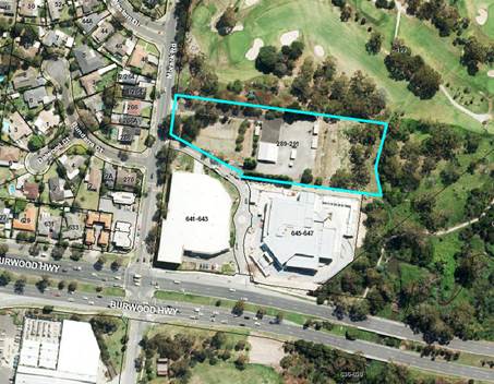
DISCUSSION
Authorisation
At the 26 June 2017 Ordinary Council Meeting, Council
resolved to seek authorisation from the Minister for Planning to prepare and
exhibit Planning Scheme Amendment C193 (the Amendment) which sought to:
· Rezone
the site from Commonwealth Land to part General Residential Zone (Schedule 5)
(GRZ5) and part Neighbourhood Residential Zone (Schedule 5) (NRZ5).
· Rezone
part of the existing Urban Flood Zone (UFZ) to the GRZ5.
· Apply
the Design and Development Overlay (Schedule 10) (DDO10) and an Environmental
Audit Overlay (EAO) to all of the land.
On 8 September 2017 the Department of Environment, Land,
Water and Planning (DELWP) authorised the Amendment subject to conditions. The
authorisation conditions and how the Amendment was modified to address these
are shown in Table 1.
Table 1. Conditions of Authorisation from DELWP and
modification to the Amendment
|
DELWP Condition in
Authorisation Letter
|
Reason
|
Modification to the
Amendment for exhibition
|
|
The application of
two residential zones on the site to guide built form is considered to be
inappropriate. The Amendment must be amended to apply the GRZ only and use
relevant overlays to guide built form (beyond the provisions in ResCode).
|
DELWP included this
condition as it was considered inappropriate to have two residential zones
applying to the site and the outcomes sought by applying the NRZ5 could be
controlled by the application of a relevant overlay.
|
The Amendment has been
updated to solely apply the GRZ5, rather than the GRZ5 and NRZ5.
|
|
The Amendment
documentation, notably the schedule to the Design and Development overlay,
must be in conformity with The Form and Content of Planning Schemes direction
including Annexure 1, Annexure 2 and Annexure 3.
|
The Minister for
Planning introduced a new Form and Content of Planning Schemes Direction
including new templates for amendment documentation. This change became
operational after the initial amendment documents had been
prepared.
|
The Amendment documents
have been updated to be consistent with the Form and Content of Planning
Schemes Direction.
|
|
The explanatory
report should be amended as per attached copy [included with the
authorisation].
|
This request was to
ensure the explanatory report addressed the two conditions above, in relation
to the zoning and form and content of planning schemes requirements.
|
The explanatory report
has been updated consistent with the copy provided by DELWP. Minor
alterations to the formatting of the explanatory report also occurred.
|
DELWPs authorisation letter also made comment on
the choice of overlay to control built form outcomes, stating the Design and
Development Overlay may not be the most appropriate tool to apply to the site
and that the VPPs contain other tools (such as the Development Plan Overlay)
that could be better utilised in achieving the built form outcomes the
responsible authority seeks for the site.
In response to this comment, the application of the DDO10 was
considered more appropriate than applying a Development Plan Overlay (DPO) to
ensure guidance is provided for applications into the future. The DDO10 will
ensure the sensitives of the adjacent land uses such as the Morack Golf Course to
the north, the Dandenong Parklands to the east, the large scale development to
the south and the existing residential area to the west are respected as part
of any subsequent planning permit applications. The DPO also automatically
removes notice requirements and third-party review rights from planning permit
applications for proposals that conform to an approved plan. Removal of third
party rights was not considered appropriate for the site due to the
sensitivities of the surrounding land uses.
Exhibition
As a result of the
authorisation conditions, the exhibited version differed from the version that
was submitted for authorisation. The exhibited Amendment proposes to:
· Rezone the land currently designated as Commonwealth Land to GRZ5.
· Rezone a portion of the land currently designated as UFZ to GRZ5.
· Apply the DDO10 to all of the land.
· Apply the EAO to all of the land.
The Amendment was
exhibited from 2 November to 4 December 2017. Three (3) submissions were
received; two (2) in support and one (1) objection.
Submissions
Table 2 provides an
overview of the submissions received during the exhibition of the Amendment.
Table 2. Summary of submission received
|
Submitter
|
Response
|
Change to the Amendment
|
|
1 - Transport for Victoria
|
Supportive
|
N/A
|
|
2 - Environment Protection Authority
|
Supportive
Supports the application of the EAO.
|
N/A
|
|
3 – Owner or occupier who resides in proximity to the site
|
Objection
· Objects to the rezoning of the UFZ land to GRZ5.
· If the flood overlay is removed this will expose new residents to
flooding and environmental pollution.
· It is not fair to future landowners/residents to have property
sold to them on a previously designated flood plain.
|
Discussions with the submitter occurred and it was apparent the
submitter believed the entire portion of the UFZ land was being rezoned to GRZ5.
It was explained to the submitter that only a small portion of the
UFZ land was being rezoned as a result of advice from Melbourne Water. The
submitter felt their concerns had been addressed and subsequently withdrew
their submission.
Therefore, no change to the Amendment is required.
|
As the only objecting submission was resolved and withdrawn,
an independent planning panel to consider the submissions is not required.
Changes to the Amendment following exhibition
DDO10
Following the authorisation and prior to the exhibition of
the Amendment, DELWP identified a minor issue with the drafting of DDO10 and
its consistency with the Form and Content of Planning Schemes direction.
DELWP stated it was not necessary to correct this before exhibition as the
change is administrative and does not alter the intent of the provision.
Table 3 identifies the exhibited version of DDO10 and the
minor change made.
Table 3. Minor changes to the exhibited version of DDO10
|
DDO10 exhibited version
|
DDO10 post exhibition change
|
|
Section 2.0 Buildings and Works
Buildings and works must be developed in accordance
with the following general requirements:
|
Section 2.0 Buildings and Works
The following buildings and works requirements apply to
an application to construct a building or construct or carry out works:
|
|
Section 5.0 Decision guidelines
An application to vary the preferred setbacks must
demonstrate how the development will achieve the requirements of this
schedule, and any local planning policy requirements. Further consideration
will be given as to whether the proposal:
· …
|
Section 5.0 Decision guidelines
The following decision guidelines apply to an
application for a permit under Clause 43.02, in addition to those specified
in Clause 43.02 and elsewhere in the scheme which must be considered, as
appropriate, by the responsible authority:
· …
|
The revised DDO10 to be adopted is provided at Attachment 1
and reflects the changes outlined in Table 3.
Mapping of the DDO and EAO
Following the authorisation and prior to the exhibition of
the Amendment, DELWP also provided feedback on the proposed extent of the
mapping of DDO10 and the EAO, suggesting these overlays need only apply to the
residentially zoned land and not to the portion of land to be zoned UFZ. DELWP
stated this change was not required to be made prior to exhibition and could be
considered at the approval stage.
Officers agree the EAO need only apply to the land to be
zoned GRZ5. The purpose of the EAO is to ensure that potentially contaminated
land is suitable for a use which could be significantly adversely affected by
any contamination such as residential use, child care centre, pre-school
centre or primary school. Considering these sensitive uses are
prohibited in the UFZ, applying the EAO is not necessary and does not make
proper use of the Victoria Planning Provisions (VPP). Therefore the version of
the Amendment to be submitted to DELWP for approval will propose to apply the
EAO to the GRZ5 land only.
Officers do not agree with DELWPs proposal to reduce the
extent of the DDO10 so it only applies to the land proposed to be zoned GRZ5.
Although the uses and buildings and works allowable under the UFZ are limited
the DDO10 contains important guidance for the land proposed to be zoned UFZ
such as:
· A
permit is required to construct any side or rear boundary fencing that exceeds
1.8 metres in height.
· Buildings
should be set back from the northern and eastern boundaries by a minimum of 3
metres.
· Transparent
fencing should be incorporated into development adjoining the Morack Golf
Course and Dandenong Creek Environs, where appropriate, with the extent of
visual permeability to be to the satisfaction of the responsible authority.
Appropriate measures must be implemented to ensure that future development on
the site is protected from activities associated with the Morack Golf Course.
Therefore it is proposed the DDO10 apply to the land to be
zoned GRZ5 and UFZ, as was sought in the
exhibited version of the amendment.
The zone and overlay mapping proposed to be applied as part
of the Amendment can be seen at Attachment 2, including the revised extent of
the EAO.
Summary
In summary, Table 4 shows the exhibited Amendment and the
changes made to these documents.
Table 4. Exhibited Amendment and Amendment to be adopted
|
Exhibited amendment
|
Amendment to be adopted and submitted to DELWP for
approval
|
|
Rezone the land currently designated as Commonwealth Land
to GRZ5.
|
No change.
Rezone the land currently designated as Commonwealth Land
to GRZ5.
|
|
Rezone a portion of the land currently designated as UFZ
to GRZ5.
|
No change.
Rezone a portion of the land currently designated as UFZ
to GRZ5.
|
|
Apply the DDO10 to all of the land.
|
Apply the DDO10 to all of the land.
The contents of the DDO10 schedule have been updated to
ensure the wording is consistent with the Form and Content of Planning
Schemes Direction.
|
|
Apply the EAO to all of the land.
|
Apply the EAO to the land proposed to be zoned GRZ5.
|
Consideration of EPA guidelines
In October 2017, the Environment Protection Authority (EPA)
released guidelines on Assessing planning proposals within the buffer of a
landfill (the guidelines). The guidelines provide information
and advice on assessing planning permit applications and planning scheme
amendments that would lead to development within the buffer of an operating or
closed landfill.
The site is in proximity to the former Nunawading landfill
at 636 – 650 Burwood Highway, Vermont South. Therefore the consideration
of the guidelines as part of the Amendment process is relevant. Advice was
sought from the EPA as to how the guidelines should be considered as the
Amendment process had already commenced prior to their finalisation. As the Amendment
is also proposing an EAO on the site, the guidelines state (as outlined below)
that a landfill gas assessment can be carried out as part of the environmental
audit (53X audit) required under the EAO rather than requiring a separate
assessment of landfill gas (53V audit), these audits are defined in sections
53X and 53V of the Environmental Protection Act 1970.
Note 4 of the guidelines state where the development also
relates to potentially contaminated land and a section 53X audit/environmental
site assessment requirement already applies, it may be possible to incorporate
landfill gas assessment into this process. In these circumstances, a separate
landfill gas risk assessment or section 53V audit would not be required.
Advice from EPA was sought and confirmed this approach.
Council also sought a letter of advice from an Environmental
Consultant which indicated it is unlikely there is an environmental risk posed
to the site from the former Nunawading landfill. Further investigations to
confirm this advice will be conducted as part of the assessment required under
the EAO.
CONSULTATION
Exhibition of the Amendment occurred from Thursday 2
November to Monday 4 December 2017. Table 5 outlines the notification methods
used to exhibit the Amendment.
Table 5. Notification of the Amendment
|
Date
|
Notification
|
|
26 October 2017 (mail)
|
Direct notification to
nearby owners and occupiers (approximately 930 letters)
|
|
26 October 2017 (mail)
and 31 October 2017 (email)
|
Direct notification to
prescribed Ministers and relevant authorities
|
|
31 October 2017 (email)
|
Notification to
relevant volunteer groups and committees of management
|
|
31 October 2017 (email)
|
Notification to Knox
City Council
|
|
20 October 2017
|
Notice in the
Whitehorse Leader
|
|
2 November 2017
|
Notice in the Victoria
Government Gazette
|
|
Duration of Exhibition
period
|
Documents available on
Whitehorse City Council and at the Whitehorse Civic Centre, Box Hill Town
Hall and Forest Hill Chase Shopping Centre Service Centres, and Vermont South
Library.
|
The Amendment was also circulated internally to the Building
and Planning, Arts and Recreation, and Property and Rates departments.
Three (3) submissions were received in response to the
Amendment; two (2) in support and one (1) objection. Conversations with the objecting
submitter occurred to clarify the intent of the Amendment and the objection was
subsequently withdrawn.
FINANCIAL IMPLICATIONS
The Amendment fees incurred
so far have been covered by the proponent, any subsequent amendment fees will
also be paid for by the proponent. Therefore there are no significant financial
implications for Council.
As per Section 19 of the Planning and Environment (Fees)
Regulations 2016 (the regulations) a planning authority may wholly or in
part waive or rebate the payment of a fee for carrying out any stage of the
planning scheme amendment process.
Under the regulations, the Stage 2 fee for the Amendment is
$14,518.60 which considers:
· Up to
and including 10 submissions which seek a change to an amendment, and where
necessary referring the submissions to a panel.
· Providing
assistance to a panel in accordance with section 159 of the Planning and
Environment Act (1987).
· Making
a submission to a panel appointed under Part 8 of the Act at a hearing referred
to in section 24(b) of the Act.
· Considering
the panel’s report in accordance with section 27 of the Act.
· After
considering submissions and the panel’s report, abandoning the amendment.
Officers reduced this fee to $1,000
for the following reasons:
· The
fee is for considering up to and including 10 submissions which seek a change
to the Amendment. There was only 1 submission that sought a change to the
Amendment.
· The
objecting submission was later withdrawn.
· The
majority of the fee is for preparing and undertaking the panel process and
considering a subsequent panel report, which is not required for this
Amendment.
The regulations provide a number of reasons as to why the
planning authority may determine it necessary to reduce the fee, in this
instance the following is relevant:
· The
request imposes on the planning authority no appreciable burden or a lesser
burden than usual for supplying that service.
The Stage 3 fee for adopting the Amendment, submitting the
Amendment for approval and giving notice of the approval was collected in full
($462.20).
POLICY IMPLICATIONS
The Amendment will place the land in a zone which falls
under the jurisdiction of the Whitehorse Planning Scheme. This will ensure any
future buildings or works applications will be assessed against the most
relevant policy.
The Amendment implements several objectives of the Council
Plan 2017 - 2021 including:
· Strategic
Direction 2: Maintain and enhance our built environment to ensure a liveable
and sustainable city – The rezoning implements this direction as it
applies a zone that is within the jurisdiction of the Whitehorse Planning
Scheme. This will support and promote greater housing diversity and housing
stock in an established urban area consistent with the existing neighbourhood
character. The proposed DDO10 will ensure future development respects and
responds to the landscape and natural environment.
· Strategic
Direction 5: Support a healthy local economy – The rezoning to GRZ5 will
generate employment during construction of the site for residential uses.
The Amendment implements Clause 21.05-2 Environment Key
Issues, Clause 21.06-3 Housing Locations, Clause 21.06-4 Housing
Diversity and Clause 22.03-2 Residential Development Objectives of
the Local Planning Policy Framework (LPPF).
The Amendment also implements Clause 11.02-1 Supply of
Urban Land, Clause 11.04-2 Housing Choice and Affordability, Clause
16.01-1 Integrated Housing, Clause 16.01-2 Location of Residential Development,
Clause 16.01-4 Housing Diversity and Clause 18.01-1 Land use and
Transport Planning of the State Planning Policy Framework (SPPF).
The Amendment implements the following Directions in Plan
Melbourne (2017 – 2050):
· Direction
2.1 – Manage the supply of new housing in the right locations to meet the
population growth and create a sustainable city.
· Direction
2.2 – Deliver more housing closer to jobs and public transport.
· Direction
2.4 – Facilitate decision making processes for housing in the right
locations.
· Direction
5.1 – Create a city of 20 minute neighbourhoods.
The Explanatory Report associated
with the Amendment can be seen at Attachment 3 and provides further discussion
about the consistency of the Amendment with the LPPF, SPPF and Plan
Melbourne (2017 – 2050).
CONCLUSION
Planning Scheme Amendment C193 was
exhibited from Thursday 2 November to Monday 4 December 2017. One (1) objecting
submission was received in response to the Amendment which was subsequently
resolved and withdrawn. Council is therefore not required to appoint an
independent planning panel to consider the submissions.
It is therefore recommended Council
adopt the Amendment with minor changes outlined in this report and submit it to
the Minister for Planning for approval. If approved, the Amendment will
come into effect once gazetted and all submitters will be notified.
Attachment
1 Revised Design
& Development Overlay Schedule 10 (DDO10) ⇨
2 Maps of
Proposed Zones & Overlays ⇨
3 Explanatory
Report ⇨
Ordinary Council Meeting 29
January 2018
Engineering
and Environmental
9.1.5 Tender
Evaluation Report (Contract 30018) Box Hill Gardens Play Space & Community
Gathering Space
SUMMARY
To consider tenders received for
the Box Hill Gardens Play Space and Community Gathering Space construction and
to recommend the acceptance of the tender received from Planned Constructions
Pty Ltd, for the amount of $745,437.
|
RECOMMENDATION
That Council accept the tender and sign the
formal contract document for Contract 30018 for the Box Hill Gardens Play
Space and Community Gathering Space received from Planned Constructions Pty
Ltd (ABN 38 084 908 645), of 161 Stubbs Street, Kensington, Victoria, 3031,
for the tendered amount of $745,437 including GST; as part of the total
expected project expenditure of $1,068,951 including GST
($971,774 excluding GST).
|
BACKGROUND
The Box Hill Gardens “Once
and Future Gardens” Masterplan was adopted by Council in February 2011.
The Masterplan provides the vision for improvements in the Gardens to better
meet Box Hill’s contextual and demographic needs. The Gardens located at
717-731 Station Street, Box Hill are north of the Box Hill business district,
and form part of the State Government designated Major Activity Centre.
The implementation of the Box Hill
Gardens Masterplan has involved significant open space improvements in recent
years. The more notable projects have included the construction of the
multipurpose area and the circuit path, improvements to public lighting
infrastructure and public open space improvements along the Nelson Road
frontage.
The current priority of the Masterplan
implementation is to construct a community gathering space and renew the
existing Municipal Level (south-eastern) play space.
The works include the construction
of hard and soft landscaping, the installation of furniture, a BBQ, multiuse
retaining / seating walls and the installation of a range of play equipment and
landscape treatments to integrate the two areas within the Gardens. Subject to
the project tendered amount, consideration would be given to the construction
of two overhead shelters as part of the Community Gathering Space.
DISCUSSION
Tenders were advertised in The Age
newspaper on Saturday 7 October 2017 and were closed on Tuesday 31 October
2017. A total of five tenders were received.
The tenders were evaluated against
the following criteria:
· The Tender Offer;
· Demonstrated experience on similar services;
· Quality of the Tenderers Work;
· Availability of the Tenderer to complete the works;
· Available resources; and
· Occupational Health & Safety and Equal Opportunity (Pass/Fail).
The tender submissions were
evaluated using a weighted averages method. Equal opportunity and Occupational
Health and Safety were assessed on a Pass / Fail basis. The results of the
assessment are summarised in the attached Tender Evaluation Form. The tender
received from Planned Constructions Pty Ltd is considered to be the most
beneficial to Council for this Contract.
Planned Constructions Pty Ltd is
experienced in these types of works, having completed similar projects for Glen
Eira City Council, Wyndham City Council and for the City of Stonnington.
Planned Constructions Pty Ltd have provided relevant information in their
Tender Response and have provided proof of their ability and availability to
complete the works associated within this Contract to a high standard.
The tender comprises of two
components which include the Play Space renewal component, involving the supply
and installation of play equipment, furniture, softfall and landscaping and,
the Community Gathering Space component which involves the construction of
retaining walls, seating, furniture, paving, landscaping, a barbeque and two
shelters.
The shelters for the Gathering
Space were listed as provisional items in the tender schedule, should there be
scope in the tendered amount to have them installed as part of this project.
The tendered amount exceeded the budget and in order to meet the allocated
budget for the Community Gathering Space both shelters, being provisional
items, have been removed from the Contract. Consideration will be given to the
installation of the shelters in future capital works budget processes. The
preliminaries (i.e. temporary fencing, set-out of works, service proving,
utilities and temporary access road set up) have been adjusted accordingly
between the Play Space and Community Gathering Space components of the tender.
Funding for the BBQ in the Gathering Space will be provided from Capital Works
Funding Account U409 – (BBQ Improvements).
The tender received from Planned
Constructions Pty Ltd is considered to be the best value for money for this
contract.
The preferred tenderer’s
business viability has been considered.
CONSULTATION
This project has been developed in
consultation with the Parks Planning and Recreation Unit (Arts and Recreation
Development), City Works, ParksWide, Health and Safety Team (Organisation
Development), Community Development Department, and various external
stakeholders.
Community consultation was
undertaken for this project as part of the development of the Box Hill Gardens
Master Plan, and again in the development of the design of the Play Space and
Community Gathering Space. Workshops were convened at various local schools and
kindergartens, and letters were circulated to stakeholders within the catchment
area of the Gardens. Onsite and online consultation was also undertaken.
All adjoining premises will be
advised in writing of the proposed works and expected impacts of construction
before works commence. A notice will be erected onsite prior to the works
commencing, notifying users that the existing south eastern (municipal level)
play space will be temporarily closed for approximately five months during
construction, and as per previous community consultation, confirming
Council’s intention to replace the two existing play spaces in Box Hill
Gardens with this new play space.
FINANCIAL IMPLICATIONS
This project is included in the
adopted 2017/2018 Council Capital Works Budget and is being funded from Account
No. U404 – Play Space Renewal Program and Account No. U418 – Box
Hill Gardens Community Gathering Space.
The financial implications for both accounts are as follows.
The project preliminaries have been adjusted accordingly between the two
components of the tender schedule. Funding for the BBQ has been provided from
Capital Works Funding Account U409 – (BBQ Improvements):
|
|
Budget
|
Expenditure
|
|
Capital
Works Funding Account No.U404
Play
Space Renewal Program
|
$ 900,000
|
|
|
Total Budget
|
$ 900,000
|
|
|
(a) Preferred tenderer’s lump sum offer
(including GST) for the Play Space Renewal project component.
|
|
$ 571,816
|
|
Less GST
|
|
-$ 51,983
|
|
Net cost to Council
|
|
$ 519,833
|
|
Plus Contingencies
|
|
$ 51,983
|
|
Plus Project Management Fee
|
|
$ 51,983
|
|
Sub Total Expenditure
|
|
$ 623,799
|
|
Commitments to date to
Account U404
|
|
$ 134,537
|
|
Tree planting and
landscaping by ParksWide
|
|
$ 26,000
|
|
(b) Play Space Total Project Expenditure (excl GST)
|
|
$ 784,336
|
|
|
|
|
|
|
|
|
|
|
Budget
|
Expenditure
|
|
Capital
Works Funding Account No. U418
Box
Hill Gardens Community Gathering Space
|
$ 175,578
|
|
|
Contribution
from Capital Works Funding Account
U409
(BBQ Improvements)
|
$ 11,860
|
|
|
Total Budget
|
$ 187,438
|
|
|
(c) Preferred
tenderer’s lump sum offer (including GST) for the Community Gathering
project component
|
|
$ 173,621
|
|
Less GST
|
|
-$ 15,784
|
|
Net cost to Council
|
|
$ 157,837
|
|
Plus Contingencies
|
|
$ 13,817
|
|
Plus Project Management Fee
|
|
$ 15,784
|
|
(d) Gathering
Space Total Expenditure (excl GST)
|
|
$ 187,438
|
|
|
|
|
|
Total Tender Lump Sum (a+c) (incl GST)
|
|
$ 745,437
|
|
Total Project Expenditure (b+d) (excl GST)
|
|
$ 971,774
|
|
Total Project Expenditure (b+d) (incl GST)
|
|
$1,068,951
|
The preferred tenderers lump sum
comprises of the Play Space renewal component of $571,816 (incl GST) and the
Community Gathering Space component of $173,621 (incl GST) for a combined
tendered amount of $745,437 (incl GST). The total project expenditure inclusive
of preliminary project costs, contingencies and project management fees is
$1,068,951 (incl GST).
Ordinary Council Meeting 29
January 2018
9.2 Corporate
Reports
9.2.1 Supplementary
Valuation Quarterly Report- 1 October 2017 to 31 December 2017
FILE NUMBER: SF16/746#02
SUMMARY
This report
presents supplementary valuations undertaken and recommends adjustment of rate
records. The supplementary valuations have been carried out on properties in
accordance with Section 13DF of the Valuation of Land Act 1960.
|
RECOMMENDATION
That Council:
1. Note and
accept the supplementary valuations undertaken during the period commencing 1
October 2017 to 31 December 2017.
2. Authorise the rate records to be adjusted to take account of the
supplementary valuations returned.
|
background
Item 1.11 of the
Schedule of Powers contained within the Chief Executive Officer’s
Instrument of Delegation adopted by Council on 21 August 2017 states the
following:
“The
delegate must not determine the issue, take the action or do the act or thing
if the issue, action, act or thing is an issue, action, act or thing which
involves:
· The return of the general valuation and any supplementary
valuations.”
This report relates to supplementary
valuations undertaken by Council in accordance with the Valuation of Land
Act 1960 for the period from 1 October 2017 to 31 December 2017.
DISCUSSION
Supplementary
valuations are conducted regularly throughout the financial year to maintain
the equity and accuracy of Council’s rating valuation base.
Supplementary
valuations are primarily due to construction, subdivision and/or planning
activities.
The supplementary
valuations undertaken are summarized in Table #1 below.
Table # 1: Supplementary Valuations completed between: 1 October 2017
and 31 December 2017
|
Supplementary Valuation Reference
|
Number of Assessments
|
SITE VALUE
|
C.I.V.
|
N.A.V.
|
|
1 October 2017
|
295
|
$ 205,725,500
|
$ 314,213,000
|
$ 17,501,500
|
|
1 November 2017
|
457
|
$ 372,815,000
|
$ 477,315,000
|
$ 24,521,050
|
|
1 December 2017
|
362
|
$ 100,209,000
|
$ 219,300,000
|
$ 11,256,000
|
|
30 December 2017
|
523
|
$ 24,132,000
|
$ 272,370,000
|
$ 14,324,200
|
|
Supplementary Valuations Total
|
1,637
|
$ 702,881,500
|
$1,283,198,000
|
$ 67,602,750
|
CONSULTATION
The legislative
requirement for Council to complete supplementary valuations is contained
within the Valuation of Land Act 1960. All supplementary
valuations contained in this report have been undertaken in accordance with the
2016 Valuation Best Practice Specifications Guidelines.
The October and
November supplementary valuations in this report have been certified by the
Valuer-General’s office (VGV) as being suitable for use by Council,
whilst the December supplementary valuations are awaiting VGV certification.
Councils may use supplementary valuations prior to VGV certification.
FINANCIAL
IMPLICATIONS
The total change
to the Capital Improved Value (CIV) caused by the supplementary valuations
undertaken is an increase of $508,839,000.
This change in CIV
has generated an additional $493,670 of
supplementary rate income.
A summary of
Council’s valuation totals for all rateable properties and non-rateable
properties are set out below in Table #2, Table #3 and Table #4.
Table #2: Valuation
totals as at 1 October 2017
|
BREAKDOWN
|
Number of assessments
|
SITE VALUE
|
C.I.V.
|
N.A.V.
|
|
Rateable
|
72,484
|
$47,395,132,200
|
$64,882,466,500
|
$ 3,352,882,300
|
|
Non Rateable
|
1,075
|
$3,106,093,000
|
$3,516,828,500
|
$199,258,500
|
|
Municipal Total
|
73,559
|
$50,501,225,200
|
$68,399,295,000
|
$3,552,140,800
|
Table#3 Change to valuation totals due to supplementary valuations
between: 1 October 2017 to
31 December 2017
|
Supplementary Valuations
|
Number of assessments subject to
Supplementary Valuation
|
Change to Site
Value
|
Change to CIV
|
Change to NAV
|
|
|
1,637
|
$ 21,297,000
|
$ 508,839,000
|
$26,869,850
|
Table #4: Valuation totals as at 31 December 2017
|
NEW BREAKDOWN
|
Number of assessments
|
SITE VALUE
|
C.I.V.
|
N.A.V.
|
|
New Rateable
|
73,406
|
$47,417,902,200
|
$65,392,204,500
|
$ 3,379,214,050
|
|
New Non Rateable
|
1,074
|
$3,104,620,000
|
$3,515,929,500
|
$199,796,600
|
|
New Municipal Total
|
74,480
|
$50,522,522,200
|
$68,908,134,000
|
$3,579,010,650
|
NB: Supplementary valuations on non-rateable properties are recorded
on Council’s rating system and their totals are included in the
supplementary valuation reports. This is because non-rateable properties
may incur a Fire Service Property Levy in accordance with the Fire Services
Property Levy Act 2012.
POLICY IMPLICATIONS
The Valuations have been undertaken
in accordance with the legislative requirements of the Valuation of Land Act
1960.
Ordinary Council Meeting 29
January 2018
9.2.2 Adoption
of Instrument of Appointment and Authorisation under the Planning and
Environment Act 1987
SUMMARY
The purpose of this report is to
recommend approval of Instrument of Appointment and Authorisation under the
Planning and Environment Act 1987, from the Council to positions in the
organisation.
|
RECOMMENDATION
That Council approve the proposed appointment of
authorised officers pursuant to the Planning and Environment Act 1987 as
attached to this report.
|
background
The proposed Instrument of
Appointment and Authorisation (pursuant to the Planning and Environment Act
1987) has been prepared following advice received from Council’s
solicitors Maddocks and is similar to that used by many Victorian
municipalities.
The Instrument of Appointment and
Authorisation allows Council officers to conduct their normal business in
relation to enforcement of the Planning and Environment Act 1987 and to
act and commence proceedings in Council’s name.
These appointments
must be made by resolution of the Council; section 3(6) of the Local
Government Act 1989 defines ‘resolution of the council’ as
including a power exercised under delegation (ie: by the Chief Executive
Officer), however section 188 (2) (c) of the Planning and Environment Act
1987 prohibits authorisations being made under delegation.
The Instruments of Appointment and
Authorisation would come into force once the common seal is affixed to the
Instrument.
CONSULTATION
Relevant staff including General
Manager City Development and Manager Planning and Building were consulted
during the preparation of the proposed Instrument of Appointment and
Authorisation.
FINANCIAL
IMPLICATIONS
There are no financial
implications.
POLICY IMPLICATIONS
There are no policy implications.
Whitehorse
City Council
Instrument
of Appointment and Authorisation
under
the Planning and Environment Act 1987
|
STAFF
|
|
Surname
|
Given
name
|
|
ABLETT
|
Meghan
|
Instrument of Appointment and Authorisation
(Planning and Environment Act 1987)
In this
instrument "officer" means:
a) Meghan Ablett
By this
instrument of appointment and authorisation Whitehorse City Council:
a) Under section 147(4) of the Planning
and Environment Act 1987 - appoints the officer(s) to be an
authorised officer(s) for the purposes of the Planning and Environment Act
1987 and the regulations made under that Act; and
b) Under section 232 of the Local
Government Act 1989 authorises the officer(s) generally to institute
proceedings for offences against the Acts and regulations described in this
instrument.
It is declared that
this instrument -
a) Comes into force immediately upon its
execution; and
b) Remains
in force until varied or revoked.
This
instrument is authorised by a resolution of the Whitehorse City Council on
29 January 2018
|
THE
COMMON SEAL OF THE WHITEHORSE CITY COUNCIL was hereunto affixed
this day of January 2018
in the
presence of:
______________________
Councillor
______________________
Chief
Executive Officer
|
)
)
)
)
)
)
)
)
)
)
)
)
)
|
Ordinary Council Meeting 29
January 2018
9.2.3 Delegated
Decisions November 2017
SUMMARY
The following activity was undertaken by officers under
delegated authority during November 2017.
|
RECOMMENDATION
That the report of decisions made by officers under
Instruments of Delegation for the month of November 2017 be noted.
|
|
DELEGATION
|
FUNCTION
|
Number for November 2016
|
Number for November 2017
|
|
Planning and Environment Act
1987
|
Delegated Decisions
|
115
|
101
|
|
Strategic Planning Decisions
|
Nil
|
Nil
|
|
Telecommunications Act 1997
|
|
Nil
|
0
|
|
Subdivision Act 1988
|
|
17
|
31
|
|
Gaming Control Act 1991
|
|
Nil
|
0
|
|
Building Act 1993
|
Dispensations & Applications to
Building Control Commission
|
80
|
85
|
|
Liquor Control Reform Act 1998
|
Objections and Prosecutions
|
1
|
2
|
|
Food Act 1984
|
Food Act Orders
|
6
|
2
|
|
Public Health & Wellbeing
Act 2008
|
Improvement /
Prohibition Notices
|
1
|
Nil
|
|
Local Government Act 1989
|
Temporary Road Closures
|
16
|
7
|
|
Other Delegations
|
CEO Signed Contracts between $150,000 -
$500,000
|
4
|
1
|
|
Property Sales and Leases
|
7
|
9
|
|
Documents to which Council seal affixed
|
1
|
1
|
|
Vendor Payments
|
924
|
1159
|
|
Parking Amendments
|
2
|
7
|
|
Parking Infringements written off (not
able to be collected)
|
240
|
252
|
DELEGATED DECISIONS MADE ON PLANNING APPLICATIONS
NOVEMBER 2017
All decisions are the
subject of conditions which may in some circumstances alter the use of
development approved, or specific grounds of refusal is an application is not
supported.
|
Appl No.
|
Dec.
Date
|
Decision
|
Street Address
|
Ward
|
Proposed Use or Development
|
Application
Type
|
|
WH/2017/506
|
27-11-17
|
Application Lapsed
|
10 Gladys Street NUNAWADING VIC 3131
|
Springfield
|
Proposed dual occupancy
|
Multiple Dwellings
|
|
WH/2017/678
|
20-11-17
|
Application Lapsed
|
12 Roselea Street BOX HILL NORTH VIC 3129
|
Elgar
|
For the construction of a double storey dwelling to
the rear of the existing dwelling
|
Multiple Dwellings
|
|
WH/2009/1/C
|
03-11-17
|
Delegate Approval - S72 Amendment
|
2 Joan Crescent BURWOOD EAST VIC 3151
|
Morack
|
Construction of a two-storey dwelling to the rear of
an existing dwelling
|
Permit Amendment
|
|
WH/2010/455/A
|
10-11-17
|
Delegate Approval - S72 Amendment
|
247 Middleborough Road BOX HILL SOUTH VIC 3128
|
Riversdale
|
Use and development of land for restricted retail,
trade supplies, landscape and gardening supplies, reduction in required car parking
and alteration of access to a road in a road zone category 1
|
Permit Amendment
|
|
WH/2010/455/B
|
10-11-17
|
Delegate Approval - S72 Amendment
|
247 Middleborough Road BOX HILL SOUTH VIC 3128
|
Riversdale
|
Use and development of land for restricted retail, trade
supplies, landscape and gardening supplies, reduction in required car parking
and alteration of access to a road in a road zone category 1
|
Permit Amendment
|
|
WH/2012/465/A
|
21-11-17
|
Delegate Approval - S72 Amendment
|
1/6 Grace Court MITCHAM VIC 3132
|
Springfield
|
Develop the land for the construction of one (1)
double storey dwelling to the rear of an existing dweling and subdivide the
land into two (2) lots plus common property
|
Permit Amendment
|
|
WH/2013/640/A
|
29-11-17
|
Delegate Approval - S72 Amendment
|
1/61 Ranfurlie Court FOREST HILL VIC 3131
|
Morack
|
Construction of two single storey dwellings to the
rear of the existing dwelling
|
Permit Amendment
|
|
WH/2015/767/B
|
17-11-17
|
Delegate Approval - S72 Amendment
|
26 Fuchsia Street BLACKBURN VIC 3130
|
Central
|
Development of land for buildings and works to extend
the existing dwelling and the addition of a domestic swimming pool and
associated pool house within a Heritage Overlay
|
Permit Amendment
|
|
WH/2016/411/A
|
21-11-17
|
Delegate Approval - S72 Amendment
|
12 Loraine Avenue BOX HILL NORTH VIC 3129
|
Elgar
|
Construction of four (4) double storey dwellings
|
Permit Amendment
|
|
WH/2016/870/A
|
08-11-17
|
Delegate Approval - S72 Amendment
|
60-68 Junction Road
BLACKBURN NORTH VIC 3130
|
Central
|
Buildings and works for new parish office and
sacristy and alterations and additions to the church
|
Permit Amendment
|
|
WH/2015/25/A
|
27-11-17
|
Delegate NOD Issued
|
22-24 Blackburn Road BLACKBURN VIC 3130
|
Central
|
Construction of a multi storey building for retail
and residential uses, reduction in car parking, waiver of loading facilities,
and alteration of access to a road in a Road Zone, Category 1
|
Permit Amendment
|
|
WH/2016/1091
|
24-11-17
|
Delegate NOD Issued
|
42 View Street MONT ALBERT VIC 3127
|
Elgar
|
The construction of two double storey dwellings
|
Multiple Dwellings
|
|
WH/2016/1166
|
27-11-17
|
Delegate NOD Issued
|
35 Loraine Avenue BOX HILL NORTH VIC 3129
|
Elgar
|
Two double storey dwellings
|
Multiple Dwellings
|
|
WH/2016/1190
|
27-11-17
|
Delegate NOD Issued
|
11-13 Canterbury Road BLACKBURN VIC 3130
|
Central
|
Development of a five (5) part six (6) storey
building with a semi basement comprising 16 dewllings, two (2) retail
premises and a car parking reduction
|
Business
|
|
WH/2016/222
|
23-11-17
|
Delegate NOD Issued
|
105 Carrington Road BOX HILL VIC 3128
|
Elgar
|
Construction of a three storey building above
basement comprising eleven dwellings and reduction in car parking
|
Multiple Dwellings
|
|
WH/2016/849
|
13-11-17
|
Delegate NOD Issued
|
7 Victor Crescent FOREST HILL VIC 3131
|
Morack
|
Construction of three double storey dwellings
|
Multiple Dwellings
|
|
WH/2016/980
|
08-11-17
|
Delegate NOD Issued
|
15 Victor Crescent FOREST HILL VIC 3131
|
Morack
|
Construction of three double storey attached
dwellings
|
Multiple Dwellings
|
|
WH/2017/143
|
15-11-17
|
Delegate NOD Issued
|
61-63 Whitehorse Road BLACKBURN VIC 3130
|
Central
|
The construction of twelve (12) dwellings contained
within an attached four storey building plus basement car parking, and
alteration of access to a road in a Road Zone, Category 1
|
Multiple Dwellings
|
|
WH/2017/189
|
21-11-17
|
Delegate NOD Issued
|
5 Joseph Street BLACKBURN NORTH VIC 3130
|
Central
|
Construction of two double storey dwellings
|
Multiple Dwellings
|
|
WH/2017/202
|
29-11-17
|
Delegate NOD Issued
|
48 Victoria Street BOX HILL VIC 3128
|
Elgar
|
Construction of three double storey dwellings
|
Multiple Dwellings
|
|
WH/2017/264
|
03-11-17
|
Delegate NOD Issued
|
7 Pear Court BURWOOD EAST VIC 3151
|
Riversdale
|
Construction of two (2) double storey dwellings
|
Multiple Dwellings
|
|
WH/2017/326
|
08-11-17
|
Delegate NOD Issued
|
13 Deep Creek Road MITCHAM VIC 3132
|
Springfield
|
Construction of two double storey dwellings
|
Multiple Dwellings
|
|
WH/2017/339
|
13-11-17
|
Delegate NOD Issued
|
97 Lake Road BLACKBURN VIC 3130
|
Central
|
Buildings and works associated with the construction
of a two storey dwelling and associated vegetation removal
|
Special Landscape Area
|
|
WH/2017/350
|
27-11-17
|
Delegate NOD Issued
|
25 Kerr Street BLACKBURN VIC 3130
|
Central
|
Construction of three double storey dwellings with
one basement
|
Multiple Dwellings
|
|
WH/2017/371
|
30-11-17
|
Delegate NOD Issued
|
2 Grigg Avenue VERMONT VIC 3133
|
Springfield
|
Construction of two (2) double storey dwellings
|
Multiple Dwellings
|
|
WH/2017/385
|
16-11-17
|
Delegate NOD Issued
|
1 Cherry Orchard Rise BOX HILL NORTH VIC 3129
|
Elgar
|
Construction of two double storey dwellings.
|
Multiple Dwellings
|
|
WH/2017/394
|
03-11-17
|
Delegate NOD Issued
|
5 Arna Street BLACKBURN VIC 3130
|
Central
|
Construction of a single storey dwelling and removal
of vegetation
|
Special Landscape Area
|
|
WH/2017/442
|
13-11-17
|
Delegate NOD Issued
|
9 Kauri Court MITCHAM VIC 3132
|
Springfield
|
Construction of two double storey dwellings
|
Multiple Dwellings
|
|
WH/2017/474
|
30-11-17
|
Delegate NOD Issued
|
179 Highbury Road BURWOOD VIC 3125
|
Riversdale
|
Construction of two double storey dwellings and
alteration of access to a road in a Road Zone, Category 1
|
Multiple Dwellings
|
|
WH/2017/567
|
21-11-17
|
Delegate NOD Issued
|
33 Hedge End Road MITCHAM VIC 3132
|
Springfield
|
Construction of two double storey units on one
allotment
|
Multiple Dwellings
|
|
WH/2017/568
|
13-11-17
|
Delegate NOD Issued
|
12 Ernest Street BLACKBURN VIC 3130
|
Central
|
Construction of 2 double storey dwellings
|
Multiple Dwellings
|
|
WH/2017/609
|
21-11-17
|
Delegate NOD Issued
|
22 Beddows Street BURWOOD VIC 3125
|
Riversdale
|
Three (3) Double Storey Dwellings
|
Multiple Dwellings
|
|
WH/2017/683
|
24-11-17
|
Delegate NOD Issued
|
428 Canterbury Road FOREST HILL VIC 3131
|
Morack
|
Construction of three (3) double storey dwellings
& subdivision into 3 lots
|
Multiple Dwellings
|
|
WH/2016/46/A
|
10-11-17
|
Delegate Permit Issued
|
39 Boisdale Street SURREY HILLS VIC 3127
|
Riversdale
|
Development of two double storey dwellings
|
Permit Amendment
|
|
WH/2017/162
|
13-11-17
|
Delegate Permit Issued
|
5 Dalroy Crescent VERMONT SOUTH VIC 3133
|
Morack
|
Construction of two (2) double storey dwellings
|
Multiple Dwellings
|
|
WH/2017/178
|
30-11-17
|
Delegate Permit Issued
|
881 Station Street BOX HILL NORTH VIC 3129
|
Elgar
|
Construction of three double storey dwellings and
alteration of access to a road in a Road Zone, Category 1
|
Multiple Dwellings
|
|
WH/2017/281
|
08-11-17
|
Delegate Permit Issued
|
11 Warnes Road\ MITCHAM VIC 3132
|
Springfield
|
Construction of two double storey dwellings
|
Multiple Dwellings
|
|
WH/2017/306
|
08-11-17
|
Delegate Permit Issued
|
36 Linlithgow Street MITCHAM VIC 3132
|
Springfield
|
Construction of two double storey dwellings
|
Multiple Dwellings
|
|
WH/2017/345
|
30-11-17
|
Delegate Permit Issued
|
8 Karen Street BOX HILL NORTH VIC 3129
|
Elgar
|
Construction of two double storey dwellings
|
Multiple Dwellings
|
|
WH/2017/368
|
13-11-17
|
Delegate Permit Issued
|
66 Joseph Street BLACKBURN NORTH VIC 3130
|
Central
|
Removal of two trees
|
Vegetation Protection Overlay
|
|
WH/2017/398
|
30-11-17
|
Delegate Permit Issued
|
19 Boronia Road VERMONT VIC 3133
|
Morack
|
Construction of one new dwelling to the rear of the
existing dwelling and to subdivide the land into two lots.
|
Subdivision
|
|
WH/2017/412
|
09-11-17
|
Delegate Permit Issued
|
32 Grove Street VERMONT VIC 3133
|
Springfield
|
Removal of trees and construction of a single storey
dwelling
|
Special Landscape Area
|
|
WH/2017/448
|
27-11-17
|
Delegate Permit Issued
|
158-160 Morack Road VERMONT SOUTH VIC 3133
|
Morack
|
Construction of four (4) double storey dwellings
|
Multiple Dwellings
|
|
WH/2017/458
|
22-11-17
|
Delegate Permit Issued
|
5/7-13 Laburnum Street BLACKBURN VIC 3130
|
Central
|
Alterations and additions to the existing dwelling
|
Single Dwelling < 300m2
|
|
WH/2017/468
|
27-11-17
|
Delegate Permit Issued
|
15 Summit Road BURWOOD VIC 3125
|
Riversdale
|
Construction of three (3) double storey dwellings
|
Multiple Dwellings
|
|
WH/2017/480
|
20-11-17
|
Delegate Permit Issued
|
153-155 Rooks Road VERMONT VIC 3133
|
Springfield
|
Change of use from Industrial to Education Facility
and a reduction of the car parking requriements of Clause 52.06
|
Industrial
|
|
WH/2017/483
|
13-11-17
|
Delegate Permit Issued
|
38 Metropolitan Avenue NUNAWADING VIC 3131
|
Springfield
|
Buildings and works to increase mezzanine floor area
and reduction of car parking
|
Industrial
|
|
WH/2017/509
|
29-11-17
|
Delegate Permit Issued
|
295A Springfield Road NUNAWADING VIC 3131
|
Springfield
|
Demolition of existing and rebuild single storey
shop/showroom and garage
|
Business
|
|
WH/2017/524
|
03-11-17
|
Delegate Permit Issued
|
4 Frankcom Street BLACKBURN VIC 3130
|
Central
|
Two lot subdivision to re-align Title boundary
between existing properties.
|
Subdivision
|
|
WH/2017/539
|
13-11-17
|
Delegate Permit Issued
|
14 Ashley Street BOX HILL NORTH VIC 3129
|
Elgar
|
Construction of two (2) double storey dwellings
|
Multiple Dwellings
|
|
WH/2017/558
|
30-11-17
|
Delegate Permit Issued
|
8 Cyril Street BOX HILL SOUTH VIC 3128
|
Riversdale
|
Construction of two (2) double storey dwellings
|
Multiple Dwellings
|
|
WH/2017/563
|
30-11-17
|
Delegate Permit Issued
|
39 Leonard Street BURWOOD VIC 3125
|
Riversdale
|
Construction of two double storey dwellings
|
Multiple Dwellings
|
|
WH/2017/573
|
03-11-17
|
Delegate Permit Issued
|
36 Gillard Street BURWOOD VIC 3125
|
Riversdale
|
Two (2) double storey dwellings
|
Multiple Dwellings
|
|
WH/2017/598
|
13-11-17
|
Delegate Permit Issued
|
29 Metropolitan Avenue NUNAWADING VIC 3131
|
Springfield
|
Construction of a building and associated reduction
of car parking requirement and display of advertising signage
|
Industrial
|
|
WH/2017/606
|
27-11-17
|
Delegate Permit Issued
|
53 Pickford Street BURWOOD EAST VIC 3151
|
Morack
|
Construction of two (2) double storey dwellings
|
Multiple Dwellings
|
|
WH/2017/635
|
03-11-17
|
Delegate Permit Issued
|
23 Drummond Street BLACKBURN SOUTH VIC 3130
|
Central
|
Construction of a studio
|
Special Landscape Area
|
|
WH/2017/696
|
24-11-17
|
Delegate Permit Issued
|
19 Duffy Street BURWOOD VIC 3125
|
Riversdale
|
Change of use to dog grooming facility
|
Industrial
|
|
WH/2017/702
|
10-11-17
|
Delegate Permit Issued
|
68A South Parade BLACKBURN VIC 3130
|
Central
|
Shop fitout and exhaust roof vent installation
resulting in a minor change in to the existing building evelope.
|
Business
|
|
WH/2017/711
|
29-11-17
|
Delegate Permit Issued
|
41-51 Burwood Highway BURWOOD VIC 3125
|
Riversdale
|
Use of the land for an Indoor recreation facility,
the display of business identification signage and alteration of access to a
road in a Road Zone, Category 1
|
Business
|
|
WH/2017/716
|
16-11-17
|
Delegate Permit Issued
|
20 Gillard Street BURWOOD VIC 3125
|
Riversdale
|
Three (3) lot subdivision
|
Subdivision
|
|
WH/2017/718
|
21-11-17
|
Delegate Permit Issued
|
462-468 Middleborough Road BLACKBURN VIC 3130
|
Central
|
Display of real estate advertising signs on
construction hoarding
|
Advertising Sign
|
|
WH/2017/722
|
29-11-17
|
Delegate Permit Issued
|
24 Albert Street MITCHAM VIC 3132
|
Springfield
|
Three (3) lot subdivision
|
Subdivision
|
|
WH/2017/735
|
16-11-17
|
Delegate Permit Issued
|
9 Erasmus Street SURREY HILLS VIC 3127
|
Riversdale
|
2 lot subdivision
|
Subdivision
|
|
WH/2017/736
|
16-11-17
|
Delegate Permit Issued
|
390 Mont Albert Road MONT ALBERT VIC 3127
|
Elgar
|
2 lot subdivision
|
Subdivision
|
|
WH/2017/739
|
20-11-17
|
Delegate Permit Issued
|
15 Peel Street MITCHAM VIC 3132
|
Springfield
|
2 Lot subdivision
|
Subdivision
|
|
WH/2017/745
|
24-11-17
|
Delegate Permit Issued
|
449 Canterbury Road VERMONT VIC 3133
|
Springfield
|
Development of an additional two storey dwelling
(retain the existing dwelling) and two lot subdivision
|
Multiple Dwellings
|
|
WH/2017/750
|
20-11-17
|
Delegate Permit Issued
|
209 Dorking Road BOX HILL NORTH VIC 3129
|
Elgar
|
2 lot subdivision
|
Subdivision
|
|
WH/2017/760
|
21-11-17
|
Delegate Permit Issued
|
5A Koroit Street NUNAWADING VIC 3131
|
Springfield
|
3 lot subdivision
|
Subdivision
|
|
WH/2017/763
|
22-11-17
|
Delegate Permit Issued
|
27 Newbigin Street BURWOOD VIC 3125
|
Riversdale
|
4 lot subdivision
|
Subdivision
|
|
WH/2017/764
|
24-11-17
|
Delegate Permit Issued
|
5 Barrina Street BLACKBURN SOUTH VIC 3130
|
Central
|
2 Lot Subdivision
|
Subdivision
|
|
WH/2017/767
|
23-11-17
|
Delegate Permit Issued
|
18 Karen Street BOX HILL NORTH VIC 3129
|
Elgar
|
Two lot subdivision
|
Subdivision
|
|
WH/2017/768
|
30-11-17
|
Delegate Permit Issued
|
133 Mount Pleasant Road FOREST HILL VIC 3131
|
Springfield
|
2 Lot Subdivision
|
Subdivision
|
|
WH/2017/778
|
30-11-17
|
Delegate Permit Issued
|
7 Halsey Street BOX HILL SOUTH VIC 3128
|
Riversdale
|
2 Lot Subdivision
|
Subdivision
|
|
WH/2017/808
|
30-11-17
|
Delegate Permit Issued
|
22-24 Blackburn Road BLACKBURN VIC 3130
|
Central
|
Major Promotion Signage
|
Advertising Sign
|
|
WH/2017/811
|
22-11-17
|
Delegate Permit Issued
|
131-173 Central Road NUNAWADING VIC 3131
|
Springfield
|
The display of signage publicising the sale of more
than 20 lots with an advertisement area greater than 10sqm
|
Advertising Sign
|
|
WH/2017/813
|
13-11-17
|
Delegate Permit Issued
|
293 Springfield Road
NUNAWADING VIC 3131
|
Springfield
|
Reduction of car parking
|
VicSmart - General Application
|
|
WH/2017/825
|
03-11-17
|
Delegate Permit Issued
|
11 Trawool Street BOX HILL NORTH VIC 3129
|
Elgar
|
Reduction in prescribed car parking for the use as a
medical centre (Osteopathic clinic)
|
VicSmart - General Application
|
|
WH/2017/828
|
01-11-17
|
Delegate Permit Issued
|
6A Dawe Road
MITCHAM VIC 3132
|
Springfield
|
Removal of one tree in a Significant Landscape
Overlay 6
|
VicSmart - General Application
|
|
WH/2017/830
|
16-11-17
|
Delegate Permit Issued
|
5 Surrey Street BOX HILL SOUTH VIC 3128
|
Riversdale
|
Two lot subdivision
|
VicSmart - Subdivision
|
|
WH/2017/838
|
03-11-17
|
Delegate Permit Issued
|
1 Lightfoot Street MONT ALBERT VIC 3127
|
Elgar
|
Demolition of two outbuildings
|
VicSmart - General Application
|
|
WH/2017/844
|
03-11-17
|
Delegate Permit Issued
|
3 Beatty Street MONT ALBERT VIC 3127
|
Elgar
|
Construction of garage within a heritage overlay
|
VicSmart - General Application
|
|
WH/2017/848
|
10-11-17
|
Delegate Permit Issued
|
220 Burwood Highway BURWOOD EAST VIC 3151
|
Morack
|
Construction of a roof over the church 'community
centre' light well
|
VicSmart - General Application
|
|
WH/2017/851
|
16-11-17
|
Delegate Permit Issued
|
49 Springvale Road NUNAWADING VIC 3131
|
Springfield
|
Two lot subdivision
|
VicSmart - Subdivision
|
|
WH/2017/876
|
13-11-17
|
Delegate Permit Issued
|
53 Alwyn Street MITCHAM VIC 3132
|
Springfield
|
Removal of one tree
|
VicSmart - General Application
|
|
WH/2017/881
|
16-11-17
|
Delegate Permit Issued
|
11 Cunningham Street BOX HILL VIC 3128
|
Elgar
|
2 lot subdivision
|
VicSmart - Subdivision
|
|
WH/2017/882
|
16-11-17
|
Delegate Permit Issued
|
103 Springvale Road NUNAWADING VIC 3131
|
Springfield
|
2 lot subdivision
|
VicSmart - Subdivision
|
|
WH/2017/883
|
22-11-17
|
Delegate Permit Issued
|
25 Eustace Street BLACKBURN VIC 3130
|
Central
|
Removal of a tree in SLO2
|
VicSmart - General Application
|
|
WH/2016/769
|
27-11-17
|
Delegate Refusal Issued
|
87 Nelson Road BOX HILL NORTH VIC 3129
|
Elgar
|
Construction of four (4) double storey dwellings
|
Multiple Dwellings
|
|
WH/2017/103
|
01-11-17
|
Delegate Refusal Issued
|
14-16 Simla Street MITCHAM VIC 3132
|
Springfield
|
Use and development of a warehouse (self storage),
child care centre and offices, reduction in standard car parking requirement
(Clause 52.06) and waiver of the loading and unloading of vehicles
requirement (Clause 52.07), realignment of boundaries and removal of easement
E-4 on PS 425700B
|
Industrial
|
|
WH/2017/171
|
22-11-17
|
Delegate Refusal Issued
|
715 Station Street BOX HILL VIC 3128
|
Elgar
|
Use and development of an 11 storey residential hotel
|
Multiple Dwellings
|
|
WH/2017/353
|
27-11-17
|
Delegate Refusal Issued
|
535 Station Street BOX HILL VIC 3128
|
Elgar
|
Electronic Promotional Sky Sign
|
Advertising Sign
|
|
WH/2017/38
|
15-11-17
|
Delegate Refusal Issued
|
7 Minna Street BLACKBURN VIC 3130
|
Central
|
Building and works for the construction of five (5)
three storey townhouses
|
Multiple Dwellings
|
|
WH/2017/421
|
16-11-17
|
Delegate Refusal Issued
|
1 Holberry StreetNUNAWADING VIC 3131
|
Springfield
|
Construction of two (2) double storey dwellings
|
Multiple Dwellings
|
|
WH/2017/423
|
28-11-17
|
Delegate Refusal Issued
|
9 St James Avenue MONT ALBERT VIC 3127
|
Elgar
|
Construction two single storey dwellings
|
Multiple Dwellings
|
|
WH/2017/605
|
23-11-17
|
Delegate Refusal Issued
|
2 Kett Street NUNAWADING VIC 3131
|
Springfield
|
Construction of two double storey dwellings
|
Multiple Dwellings
|
|
WH/2017/879
|
15-11-17
|
Delegate Refusal Issued
|
5 Erilyn Court VERMONT VIC 3133
|
Springfield
|
Remove 1 tree within SLO7
|
VicSmart - General Application
|
|
WH/1976/901273/A
|
23-11-17
|
No Permit Required
|
10 Florence Road SURREY HILLS VIC 3127
|
Riversdale
|
internal alterations to existing dwelling
|
Permit Amendment
|
|
WH/2017/893
|
30-11-17
|
No Permit Required
|
144 Rooks Road
NUNAWADING VIC 3131
|
Springfield
|
Change of use for food preparation for off-site
catering
|
Business
|
|
WH/2015/306/A
|
03-11-17
|
Withdrawn
|
9-21 Cook Road MITCHAM VIC 3132
|
Springfield
|
Develop and use of 21 warehouses and reduction in the
standard car parking requirments
|
Permit Amendment
|
|
WH/2017/731
|
01-11-17
|
Withdrawn
|
31 Gerald Street BLACKBURN VIC 3130
|
Springfield
|
2 lot subdivision
|
Subdivision
|
|
WH/2017/787
|
14-11-17
|
Withdrawn
|
2/9 Tasman Avenue NUNAWADING VIC 3131
|
Springfield
|
Deck extension and new pergola
|
Single Dwelling < 300m2
|
BUILDING DISPENSATIONS/APPLICATIONS
NOVEMBER 2017
|
Address
|
Date
|
Ward
|
Result
|
|
2 O'Hara Street, BLACKBURN
|
24-11-17
|
Central
|
Amendment Approved R409
|
|
1 Junction Road, BLACKBURN NORTH
|
10-11-17
|
Central
|
Consent Granted R409
|
|
15 Joseph Street, BLACKBURN NORTH
|
23-11-17
|
Central
|
Consent Granted R409
|
|
15 Wilton Street, BLACKBURN NORTH
|
08-11-17
|
Central
|
Consent Granted R414
|
|
18 Aberdeen Road, BLACKBURN SOUTH
|
03-11-17
|
Central
|
Consent Granted R409,R410,R415,R417
|
|
2 Jessie Street, BLACKBURN NORTH
|
10-11-17
|
Central
|
Consent Granted R409, R414
|
|
2 O'Hara Street, BLACKBURN
|
03-11-17
|
Central
|
Consent Granted R414
|
|
21 Fithie Street, BLACKBURN NORTH
|
15-11-17
|
Central
|
Consent Granted R409
|
|
26 Patricia Road, BLACKBURN
|
14-11-17
|
Central
|
Consent Granted R416
|
|
30 Lantana Street, BLACKBURN NORTH
|
21-11-17
|
Central
|
Consent Granted R417
|
|
41 Slater Avenue, BLACKBURN NORTH
|
29-11-17
|
Central
|
Consent Granted R409, R414
|
|
6 Lobelia Court, BLACKBURN NORTH
|
01-11-17
|
Central
|
Consent Granted R414,R409
|
|
16 Katrina Street, BLACKBURN NORTH
|
23-11-17
|
Central
|
Consent Refused R409
|
|
3 Mansfield Street, BLACKBURN SOUTH
|
14-11-17
|
Central
|
Consent Refused R424
|
|
41 Slater Avenue, BLACKBURN NORTH
|
29-11-17
|
Central
|
Consent Refused R417
|
|
9 Douglas Street, BLACKBURN NORTH
|
10-11-17
|
Central
|
Consent Refused R424
|
|
1/10 Broomhill Avenue, BLACKBURN
|
30-11-17
|
Central
|
Expired R409
|
|
6 Belvedere Court, BLACKBURN NORTH
|
09-11-17
|
Central
|
Expired
|
|
1 Costello Street, MONT ALBERT NORTH
|
16-11-17
|
Elgar
|
Consent Granted R411
|
|
12 Jackson Avenue, MONT ALBERT NORTH
|
08-11-17
|
Elgar
|
Consent Granted R409
|
|
12 Jackson Avenue, MONT ALBERT NORTH
|
08-11-17
|
Elgar
|
Consent Granted R412
|
|
12 Serpentine Street, MONT ALBERT
|
30-11-17
|
Elgar
|
Consent Granted R409
|
|
17 Lincoln Avenue, MONT ALBERT NORTH
|
27-11-17
|
Elgar
|
Consent Granted R424
|
|
2/17 View Street, MONT ALBERT
|
16-11-17
|
Elgar
|
Consent Granted R411
|
|
35 Kingsley Crescent, MONT ALBERT
|
08-11-17
|
Elgar
|
Consent Granted R410, R415
|
|
553 Middleborough Road, BOX HILL NORTH
|
21-11-17
|
Elgar
|
Consent Granted R409
|
|
56 Dunloe Avenue, MONT ALBERT NORTH
|
08-11-17
|
Elgar
|
Consent Granted R424
|
|
6 St Johns Avenue, MONT ALBERT
|
16-11-17
|
Elgar
|
Consent Granted R424
|
|
6 Tyrrell Street, MONT ALBERT NORTH
|
16-11-17
|
Elgar
|
Consent Granted R414
|
|
68 Boondara Road, MONT ALBERT NORTH
|
29-11-17
|
Elgar
|
Consent Granted R427,R424
|
|
7-9 Carrington Road, BOX HILL
|
24-11-17
|
Elgar
|
Consent Granted R604
|
|
3 Blenheim Avenue, MONT ALBERT
|
29-11-17
|
Elgar
|
Consent Refused R415
|
|
14 Theodore Street, SURREY HILLS
|
30-11-17
|
Elgar
|
Expired R409
|
|
8 Albion Road, BOX HILL
|
09-11-17
|
Elgar
|
Expired R409
|
|
14 Penllyne Avenue, VERMONT
|
24-11-17
|
Morack
|
Amendment Refused R424
|
|
2 Brentford Square, FOREST HILL
|
28-11-17
|
Morack
|
Consent Granted R604
|
|
2 Tisane Avenue, FOREST HILL
|
30-11-17
|
Morack
|
Consent Granted R411
|
|
30 Sevenoaks Road, BURWOOD EAST
|
30-11-17
|
Morack
|
Consent Granted R419
|
|
5 Cheriton Court, BURWOOD EAST
|
29-11-17
|
Morack
|
Consent Granted R409
|
|
17 Talarno Avenue, VERMONT SOUTH
|
30-11-17
|
Morack
|
Expired R414
|
|
1/24 Highview Grove, BURWOOD EAST
|
30-11-17
|
Riversdale
|
Consent Granted R424
|
|
18 Gibson Street, BOX HILL SOUTH
|
09-11-17
|
Riversdale
|
Consent Granted R424
|
|
19 Hastings Avenue, BLACKBURN SOUTH
|
16-11-17
|
Riversdale
|
Consent Granted R424
|
|
1B Scottsdale Street, SURREY HILLS
|
13-11-17
|
Riversdale
|
Consent Granted R414
|
|
20 Campbell Parade, BOX HILL SOUTH
|
23-11-17
|
Riversdale
|
Consent Granted R414
|
|
22 Dorothy Street, BURWOOD EAST
|
03-11-17
|
Riversdale
|
Consent Granted R414
|
|
24 Everton Grove, SURREY HILLS
|
29-11-17
|
Riversdale
|
Consent Granted R414
|
|
27 Narmara Street, BURWOOD EAST
|
13-11-17
|
Riversdale
|
Consent Granted R427
|
|
6 Monash Street, BOX HILL SOUTH
|
09-11-17
|
Riversdale
|
Consent Granted R420
|
|
904 Canterbury Road, BOX HILL SOUTH
|
22-11-17
|
Riversdale
|
Consent Granted
|
|
24 Everton Grove, SURREY HILLS
|
29-11-17
|
Riversdale
|
Consent Refused R417
|
|
27 Patterson Avenue, BURWOOD
|
10-11-17
|
Riversdale
|
Consent Refused R424
|
|
32 Grange Road, BLACKBURN SOUTH
|
08-11-17
|
Riversdale
|
Consent Refused R409
|
|
10 Wattlebird Court, BURWOOD
|
30-11-17
|
Riversdale
|
Expired R414
|
|
2 Sycamore Street, BOX HILL SOUTH
|
09-11-17
|
Riversdale
|
Expired R409
|
|
1/25 Luckie Street, NUNAWADING
|
08-11-17
|
Springfield
|
Consent Granted R409
|
|
14 Milton Street, NUNAWADING
|
16-11-17
|
Springfield
|
Consent Granted R411,R414
|
|
18 Bristow Drive, FOREST HILL
|
30-11-17
|
Springfield
|
Consent Granted R410,R415
|
|
24 Hedge End Road, NUNAWADING
|
27-11-17
|
Springfield
|
Consent Granted R414, R426
|
|
2A Price Street, MITCHAM
|
08-11-17
|
Springfield
|
Consent Granted R410,R415
|
|
31 Barkly Terrace, MITCHAM
|
16-11-17
|
Springfield
|
Consent Granted R414
|
|
4 Latham Court, FOREST HILL
|
30-11-17
|
Springfield
|
Consent Granted R414
|
|
68 Cochrane Street, MITCHAM
|
30-11-17
|
Springfield
|
Consent Granted R409, R414
|
|
7 Scott Street, MITCHAM
|
02-11-17
|
Springfield
|
Consent Granted R414, R417
R411
|
|
9 O'Shannessy Street, NUNAWADING
|
14-11-17
|
Springfield
|
Consent Granted R409
|
|
1 Alexander Street, MITCHAM
|
14-11-17
|
Springfield
|
Consent Refused R409
|
|
1 Carter Avenue, NUNAWADING
|
08-11-17
|
Springfield
|
Consent Refused R409
|
|
14 Milton Street, NUNAWADING
|
16-11-17
|
Springfield
|
Consent Refused R415
|
|
20 Taronga Court, NUNAWADING
|
29-11-17
|
Springfield
|
Consent Refused R409
|
|
38 Rosstrevor Crescent, MITCHAM
|
21-11-17
|
Springfield
|
Report Closed
|
DELEGATED
DECISIONS MADE ON STRATEGIC PLANNING MATTERS – NOVEMBER 2017
Under the Planning and Environment Act 1987
REGISTER OF CONTRACTS SIGNED BY CEO DELEGATION NOVEMBER
2017
|
Contract
|
Service
|
|
Contract 30005
|
Houston Shopping Centre
Streetscape Improvements
|
REGISTER OF PROPERTY
DOCUMENTS EXECUTED NOVEMBER 2017
|
Property Address
|
Document Type
|
Document
Detail
|
|
Leases
|
|
|
|
69 Katrina Street, Blackburn North - Katrina Pre School
Association
|
Assignment of Lease
|
New tenant - Bestchance Child Family Care
|
|
Part 2-10 Deep Creek Road, Mitcham - Local History Room -
Schwerkolt Cottage and Museum Complex
|
Lease
|
Whitehorse Historical Society Incorporated
|
|
21 Wattle Valley Road, Mitcham
|
Residential Tenancy Agreement
|
Tenant name withheld for privacy
|
|
Licences
|
|
|
|
2-4 Bruce Street and adjoining discontinued road,
Box Hill - MAB Bruce Street Pty Ltd
|
Licence Agreement
|
Licence to MAB Bruce Street Pty Ltd for site
investigations
|
|
Blackburn Railway Station forecourt - part 1 South
Parade, Blackburn - Metro Trains Melbourne
|
Licence Agreement
|
Agreement for Exeloo toilet facility
|
|
Fires Services Property Levy
(FSPL)
|
|
|
|
437 Belmore Road Mont Albert North
|
|
Land use changed from 'Residential' to 'Commercial'
|
|
86 Carrington Road, Box Hill
|
|
Land use changed from 'Public Benefit' to 'Commercial'
|
|
Rateability Changes
(Section 154 of Local
Government Act)
|
|
|
|
2 Carrington Road, Box Hill
|
Property Now Rateable
|
Property sold by Council
|
|
86 Carrington Road, Box Hill
|
Property Now Rateable
|
Part of Greek Orthodox Church property leased to tenant
for use as a Child Care Centre
|
REGISTER OF DOCUMENTS AFFIXED WITH THE COUNCIL SEAL
– NOVEMBER 2017
Instrument of Sub Delegation Chief Executive Officer to
staff (Under CEO Delegation 08.17.17)
PARKING RESTRICTIONS APPROVED BY DELEGATION NOVEMBER 2017
Address: Nicholson Street, Nunawading:
from Whitehorse Road service road to Tunstall
Avenue – west side
Previously: 20 ‘Unrestricted’
parking spaces
Now: 20
‘2-Hour, 8am to 6pm, Monday to Friday’ parking spaces
Address: Uganda Street, Burwood: from east boundary of 21 Uganda
Street to west boundary of 21 Uganda Street –
south side
Previously: 2 ‘1/2-Hour,
7.30am to 9pm, Monday to Saturday’ parking spaces
Now: 2
‘Works Zone, 7am to 5pm, Monday to
Saturday' parking spaces
Address: Spencer Street, Nunawading: from east boundary of 2 Spencer Street to west boundary of 2 Spencer
Street – south side
Previously: 2 ‘Unrestricted’ parking spaces
Now: 2
‘5-minute, 7am to 6pm, Monday to Friday’ parking spaces
Address: Short Street, Vermont: from
15m north of the south boundary of 7 Short Street to 22m west of the east
boundary of 7 Short Street – south side
Previously: 3 ‘Permit
Zone, 8am to 6pm, Monday to Friday’ parking spaces
Now: 3
‘No Stopping’ parking spaces
Address: Fankhauser Drive, Vermont: from Beacon Street to 15m west of Beacon Street – west side
Previously: 1 ‘Unrestricted’ parking space
Now: 1
‘No Stopping’ parking space
Address: Beacon Street, Vermont: from
Fankhauser Drive to 20m south of Fankhauser Drive – east side
Previously: 2 ‘Unrestricted’ parking
spaces
Now: 2
‘No Stopping’ parking spaces
Address: Beacon Street, Vermont: from
Fankhauser Drive to 15m south of Fankhauser Drive – west side
Previously: 1 ‘Unrestricted’ parking space
Now: 1
‘No Stopping’ parking space
VENDOR PAYMENT SUMMARY
– SUMS PAID DURING NOVEMBER 2017
|
Date
|
Total
Issued
|
Payments (direct debit, cheques or electronic funds
transfer)
|
Transaction Type EFT/CHQ/DD
|
|
02/11/2017
|
$2,628.37
|
12
|
EFC
|
|
02/11/2017
|
$53,670.65
|
46
|
CHQ
|
|
02/11/2017
|
$198,250.62
|
26
|
EFT
|
|
02/11/2017
|
$240,475.89
|
18
|
EFT
|
|
08/11/2017
|
$23,816.56
|
1
|
EFT
|
|
09/11/2017
|
$973.50
|
3
|
EFC
|
|
09/11/2017
|
$32,621.39
|
34
|
CHQ
|
|
09/11/2017
|
$485,351.95
|
33
|
EFT
|
|
14/11/2017
|
$7,445.52
|
1
|
EFT
|
|
16/11/2017
|
$5,682.14
|
17
|
EFC
|
|
16/11/2017
|
$102,847.18
|
41
|
CHQ
|
|
16/11/2017
|
$3,361,440.97
|
415
|
EFT
|
|
23/11/2017
|
$2,417.45
|
9
|
EFC
|
|
23/11/2017
|
$32,119.25
|
24
|
CHQ
|
|
23/11/2017
|
$475,847.78
|
46
|
EFT
|
|
28/11/2017
|
$1,918.95
|
1
|
EFC
|
|
30/11/2017
|
$31,002.03
|
10
|
EFT
|
|
30/11/2017
|
$7,181.68
|
12
|
EFC
|
|
30/11/2017
|
$4,367,903.00
|
382
|
EFT
|
|
30/11/2017
|
$46,317.64
|
37
|
CHQ
|
|
GROSS
|
$9,479,912.52
|
1168
|
|
|
|
|
|
|
Monthly
Lease Payments
|
$35,674.82
|
|
|
|
Direct
Debit Payments
|
$91,584.27
|
|
|
|
|
|
|
|
CANCELLED
PAYMENTS
|
-$10,914.20
|
-9
|
|
|
NETT
|
$9,596,257.41
|
1159
|
|
Ordinary Council Meeting 29
January 2018
10 Reports
from Delegates, Special Committee Recommendations and Assembly of Councillors
Records
10.1 Reports
by Delegates
|
RECOMMENDATION
That the reports
from delegates be received and noted.
|
10.2 Recommendations
from the Special Committee of Council Meeting
10.3 Record
of Assembly of Councillors
|
Meeting Date
|
Matter/s
Discussed
|
Councillors
Present
|
Officers Present
|
Disclosures of Conflict of Interest
|
Councillor
/Officer attendance following disclosure
|
|
11-12-17
6.30-7.00pm
|
Councillor Briefing Session
· 6.1
& 6.2 Notices of Motion
· Urgent
Business – Francom Street Blackburn
· Item9.1.1826-834
Whitehorse Road, Box Hill (Lots 3 & 4 Ps 434842DS)
|
Cr Davenport (Mayor & Chair)
Cr Barker
Cr Bennett
Cr Carr
Cr Cutts
Cr Ellis
Cr Liu
Cr Massoud
Cr Munroe
Cr Stennett (arrived at 6.36pm)
|
N Duff
J Green
P Warner
T Wilkinson
P Smith
A De Fazio
S Freud
J Russell
|
Nil
|
Nil
|
|
22-01-18
5.30-6.15pm
|
North East Link Authority
|
Cr Davenport (Mayor & Chair)
Cr Barker
Cr Bennett
Cr Carr
Cr Cutts
Cr Liu
Cr Massoud
Cr Munroe
|
N Duff
J Green
P Warner
T Wilkinson
(AGMC) S Cann
A De Fazio
S Freud
J Nikas
L McGuiness
K Sinclair
|
Nil
|
Nil
|
|
22-01-18
7.00-9.00pm
|
Councillor Briefing Session
· Finance
Report as at 30 November 2017
· Draft
Council Agenda 29 January 2018
· Budget
Update
· Australia
Day Proceedings
· Confidential
Matter
|
Cr Davenport (Mayor & Chair)
Cr Barker
Cr Bennett
Cr Carr
Cr Cutts
Cr Liu
Cr Massoud
Cr Munroe
Cr Stennett
|
N Duff
J Green
P Warner
T Wilkinson
(AGMCS) S Cann
A De Fazio
S Freud
K Marriott
J Hansen
A Egan
|
· Cr
Liu Declared an Indirect Conflict of Interest in Item 9.1.3 Amendment C194
to the Whitehorse Planning Scheme (517 & 519-521 Station Street &
2-8 Oxford Street, Box Hill).
· To meet
Probity requirements Mr J Green & S Cann were required to remove
themselves from the meeting when Item
Amendment C194 to the Whitehorse Planning
Scheme (517 & 519-521 Station Street & 2-8 Oxford Street, Box Hill)
was discussed
|
· Cr Lui,
declared an Indirect Conflict of Interest
in
Item 9.1.3 Amendment C194 to the
Whitehorse Planning Scheme (517 & 519-521 Station Street & 2-8
Oxford Street, Box Hill) left the meeting at 8.05pm, returning at 8.30pm
· Mr J Green
& Mr S Cann ,
Item 9.1.3 Amendment C194 to the
Whitehorse Planning Scheme (517 & 519-521 Station Street & 2-8
Oxford Street, Box Hill) left the meeting at 8.05pm, returning at 8.30pm.
|
|
RECOMMENDATION
That the record of
Assembly of Councillors be received and noted.
|
11 Reports
on Conferences/Seminars Attendance
|
RECOMMENDATION
That the record of reports on
conferences/seminars attendance be received and noted.
|
12 Confidential
Reports
Nil
13 Close Meeting