Ordinary
Council Meeting
To be held in the
Council Chamber
Whitehorse Civic Centre
379 Whitehorse Road Nunawading
on
Tuesday 29 January 2019
at 7:00pm
Members: Cr
Bill Bennett (Mayor), Cr Blair Barker, Cr Raylene Carr,
Cr Prue Cutts, Cr Andrew Davenport, Cr Sharon Ellis, Cr Tina
Liu,
Cr
Denise Massoud, Cr Andrew Munroe, Cr Ben Stennett
Ms Noelene Duff
Chief
Executive Officer
|
Recording of Meeting and Disclaimer
Please
note every Ordinary Council Meeting (other than items deemed confidential
under section 89(2) of the Local Government Act 1989) is being recorded and
streamed live on Whitehorse City Council’s website in accordance with
Council's Live Streaming and Recording of Meetings Policy. A copy of the
policy can also be viewed on Council’s website.
The recording will be archived and made publicly
available on Council's website within 48 hours after the meeting on
www.whitehorse.vic.gov.au for a period of three years (or as otherwise agreed
to by Council).
Live streaming allows everyone to watch and listen to
the meeting in real time, giving you greater access to Council debate and
decision making and encouraging openness and transparency.
All
care is taken to maintain your privacy; however, as a visitor in the public
gallery, your presence may be recorded. By remaining in the public gallery,
it is understood your consent is given if your image is inadvertently
broadcast.
Opinions expressed or
statements made by individual persons during a meeting are not the opinions
or statements of Whitehorse City Council. Council therefore accepts no
liability for any defamatory remarks that are made during a meeting.
|
Ordinary Council Meeting 29
January 2019
AGENDA
1 PRAYER
1a Prayer
for Council
We give thanks, O God, for the Men and Women of the past whose generous
devotion to the common good has been the making of our City.
Grant that our own
generation may build worthily on the foundations they have laid.
Direct our minds
that all we plan and determine, is for the wellbeing of our City.
Amen.
1b Aboriginal
Reconciliation Statement
“In the
spirit of reconciliation, Whitehorse City Council acknowledges the Wurundjeri
people as the traditional custodians of the land we are meeting on. We pay our
respects to their Elders past and present.”
2 WELCOME
AND APOLOGIES
Cr Stennett has sought a leave of absence for
tonight’s Ordinary Council Meeting 29 January 2019.
RECOMMENDATION
That the apology for Cr Stennett be received
and leave of absence for tonight’s Ordinary Council Meeting 29 January
2019 be granted.
3 DISCLOSURE
OF CONFLICT OF INTERESTS
4 CONFIRMATION
OF MINUTES OF PREVIOUS MEETINGS
Minutes of the Ordinary Council Meeting 10 December
2018 and Confidential Ordinary Council Meeting 10 December 2018.
|
RECOMMENDATION
That the minutes of the Ordinary Council Meeting
10 December 2018 and Confidential Ordinary Council Meeting 10 December 2018
having been circulated now be confirmed.
|
5 RESPONSES
TO QUESTIONS
6 Notices
of Motion
7 Petitions
8 Urgent
Business
9.1 City
Development
Statutory Planning
9.1.1 25 Holland
Road, Blackburn South (Lot 1 TP 599873E) Construction of five double storey
dwellings, associated front fence and other works
FILE NUMBER: WH/2018/855
ATTACHMENT
SUMMARY
This application was advertised
on 17th September 2018, following which seventeen (17) objections
were received. The objections raised issues with regard to neighbourhood
character, landscape character, parking and traffic, amenity impacts and
drainage. A Consultation Forum was held on Tuesday 27 November 2018 and was
chaired by Councillor Munroe, at which the issues were explored, however no
resolution was reached between the parties.
Following the Consultation
Forum, a revised site plan and landscape plan was submitted, tabled as
‘without prejudice plans’, seeking to address outstanding concerns
of Council and issues raised by objecting parties. These amended plans have not
been re-advertised as the changes do not result in additional material
detriment to adjoining owners and occupiers but were circulated to objectors
for additional comment. An existing objector provided additional comments, but
introduced no additional objection grounds.
The without
prejudice plans introduce a number of improvements to the proposal, namely: a
second additional visitor car space, improved turning areas for visitor
parking, widened landscape strips and revised plant species adjacent to the
accessway.
This report
assesses the application against the relevant provisions of the Whitehorse
Planning Scheme, as well as objector concerns. It is recommended that the
application be supported, subject to conditions.
|
RECOMMENDATION
That Council:
A. Being the Responsible Authority, having
caused application WH/2018/855 at 25 Holland Road, BLACKBURN SOUTH (Lot 1 TP
599873E) to be advertised and having received and noted the objections is of
the opinion that the granting of a Planning Permit for the Construction of
five double storey dwellings, associated front fence and other works, is
acceptable and should not unreasonably impact the amenity of adjacent
properties.
B. Issue a Notice of Decision to Grant a Permit
under the Whitehorse Planning Scheme to the land described as 25 Holland
Road, BLACKBURN SOUTH (Lot 1 TP 599873E) for the Construction of five double
storey dwellings, associated front fence and other works, subject to the
following conditions:
1. Before
the development starts, amended plans (in digital format) must be submitted
to and approved by the Responsible Authority. When approved, the plans
will be endorsed and will then form part of the permit. The plans must
be drawn to scale, with dimensions, and be generally in accordance with the plans
submitted with the application, including the ‘Without Prejudice
Plans’ received 19th December 2018, but modified to show:
a. The
garage of dwelling 1 widened by 0.4 metres, and the respective lounge wall
forward of this garage relocated 0.4 metres west, to facilitate appropriate
turning manoeuvres.
b. The
eastern lounge wall of dwelling 2 forward of the respective garage relocated
0.4 metres west, to facilitate appropriate turning manoeuvres.
c. The
landscape strip immediately south-east of the garage for dwelling 1 more
heavily splayed south-east to facilitate appropriate turning manoeuvres.
d. A
window added to the southern portion of the western wall concerning the
master bedroom for both dwellings 2 and 4.
e. All
render finishes must be applied on top of either a brick or timber
weatherboard cladding.
f. A
passing area and widened crossover provided in accordance with Clause 52.06
that does not encroach within the Tree Protection Zone of street Tree 1.
g. The
locations of Tree Protection Zones described in Condition 5, with all
nominated trees clearly identified and numbered on both site and landscape
plans, and the requirements of Conditions 5, 6, and 7 to be annotated on the
development and landscape plans.
h. A
notation on the plans that confirms no soil level changes within the Tree
Protection Zones of any adjoining trees specified within Condition 5 of this
permit.
i. Water
tanks to be located outside of Tree Protection Zones and proposed Tree
Planting Envelopes where possible to the satisfaction of the Responsible
Authority.
j. Notation
on site plans indicating that all obscured glazing be manufactured obscured
glass. Obscure film being applied to clear glazing will not be
accepted.
k. A
Sustainable Design Assessment in accordance with Condition 10 of this Permit.
All of the above requirements must be to the
satisfaction of the Responsible Authority. Once approved these plans
and documents become the endorsed plans of this permit.
2. The
layout of the site and the size, design and location of the buildings and
works permitted must always accord with the endorsed plan and must not be
altered or modified without the further written consent of the Responsible
Authority.
3. The
garden areas shown on the endorsed plan and schedule must only be used as
gardens and shall be maintained in a proper, tidy and healthy condition to
the satisfaction of the Responsible Authority. Should any tree or shrub
be removed or destroyed it may be required to be replaced by a tree or shrub
of similar size and variety.
4. The
landscape works as shown on the endorsed plan must be carried out prior to
occupation of the permitted development, or if not occupied, within three
months of completion of the permitted development. With written consent of
the Responsible Authority landscaping may be deferred to the first planting
season (May to September) following the completion of the permitted buildings
and/or works. New planting must be maintained or replaced as necessary to the
satisfaction of the Responsible Authority.
5. Prior
to the commencement of any building and or demolition works on the land, a
Tree Protection Zone (TPZ) must be established on the subject site and
maintained during and until completion of all buildings and works including
landscaping, around the following trees in accordance with the distances and
measures specified below, to the satisfaction of the Responsible Authority:
Tree Protection Zone distances:
a. Tree
1 (Lophostemon confertus – Queensland Brush Box) – 7.1 metre
radius from the centre of the tree base.
b. Tree
2 (Callistemon citrinus – Crimson Botllebrush) – 3.9 metre radius
from the centre of the tree base.
c. Tree
3 (Eucalyptus melliodora – Yellow Box) – 6.3 metre radius from
the centre of the tree base.
d. Tree
4 (Allocasuarina verticilliata – Drooping She-oak) – 5.9 metre
radius from the centre of the tree base.
e. Tree
5 (Eucalyptus rubida – Candlebark) – 4.4 metre radius from the
centre of the tree base.
f. Tree
6 (Eucalyptus sp – Gum) – 7.4 metre radius from the centre of the
tree base.
g. Tree
7 (Callistemon citrinus – Crimson Bottlebrush) – 7.1 metre radius
from the centre of the tree base.
h. Tree
8 (Eucalyptus sp – Gum) – 3.9 metre radius from the centre of the
tree base.
i. Tree
9 (Eucalyptus sideroxylon – Red lronbark) – 6.3 metre radius from
the centre of the tree base.
j. Tree
10 (Eucalyptus polyanthemos –Red Box) – 5.9 metre radius from the
centre of the tree base.
k. Tree
11 (Eucalyptus leucoxylon – Yellow Gum) – 4.4 metre radius from
the centre of the tree base.
l. Tree
12 (Callistemon viminalis – Weeping Bottlebrush) – 7.4 metre
radius from the centre of the tree base.
m. Tree
13 (Eucalyptus nicholii – Willow-leaf Peppermint) – 7.1 metre
radius from the centre of the tree base.
n. Tree
14 (Eucalyptus obliqua – Messmate) – 3.9 metre radius from the
centre of the tree base.
6. Tree
Protection Zone measures are to be established in accordance to Australian
Standard 4970-2009 and including the following:
a. Erection
of solid chain mesh or similar type fencing at a minimum height of 1.8 metres
held in place with concrete feet.
b. Signage
placed around the outer edge of perimeter fencing identifying the area as a
TPZ. The signage should be visible from within the development, with the
lettering complying with AS 1319.
c. Mulch
across the surface of the TPZ to a depth of 100mm and undertake supplementary
watering in summer months as required.
d. No
excavation, constructions works or activities, grade changes, surface treatments
or storage of materials of any kind are permitted within the TPZ unless
otherwise approved within this permit or further approved in writing by the
Responsible Authority.
e. All
supports, and bracing should be outside the TPZ and any excavation for
supports or bracing should avoid damaging roots where possible.
f. No
trenching is allowed within the TPZ for the installation of utility services
unless tree sensitive installation methods such as boring have been approved
by the Responsible Authority.
g. Where
construction is approved within the TPZ, fencing and mulching should be
placed at the outer point of the construction area.
h. Where
there are approved works within the TPZ, it may only be reduced to the
required amount by an authorised person only during approved construction
within the TPZ and must be restored in accordance with the above requirements
at all other times.
7. During
the construction of any buildings or works, the following tree protection
requirements must be carried out to the satisfaction of the Responsible
Authority:
a. The paved areas where within
the TPZ of Tree 1 must be above the existing soil grade using porous
materials that allows water to penetrate through the surface and into the
soil profile. There must be no grade change within greater than 10% of the
TPZ’s and no roots greater than 40mm in diameter are to be cut or
damaged during any part of the construction process.
b. Any buildings and works
(including retaining walls) that extend into the TPZ of any existing tree
must be done by hand, hydro excavation or air spading under the supervision
of an arborist. If any roots are encountered, the posts or works protruding
into the ground must be relocated a minimum of 300mm from these roots.
c. The project arborist and builder
must ensure that TPZ Fencing Conditions are being adhered to throughout the
entire building process, including site demolition, levelling and landscape
works.
8. Council's
Compliance Officer must be advised of the completion of all tree planting
required by this permit so that a site inspection can be carried out. A
further inspection will be carried out 6 months after the completion of the
landscaping to ensure that the planting has been adequately maintained.
9. All
waste must be carried out in accordance with the Waste Management Plan
prepared by Frater consulting services, dated 8th June 2018 to the
satisfaction of the Responsible Authority.
10. Prior
to the commencement of any buildings or works, a Sustainable Design
Assessment (SDA) must be submitted to and approved by the Responsible
Authority. In particular, this should address the need to protect the
internal amenity of the upper levels from the thermal impacts of the west
facing windows.
Once submitted and approved to the satisfaction
of the Responsible Authority, the Sustainable Design Assessment will form
part of the endorsed plans under this permit.
The requirements of the
Sustainable Design Assessment must be demonstrated on the plans and
elevations submitted for endorsement, and the requirements of this plan must
be implemented by the building manager, owners and occupiers of the site when
constructing and fitting out the residential building, and for the duration
of the building’s operation in accordance with this permit, to the
satisfaction of the Responsible Authority.
Prior to the occupation of the development,
the development must be constructed in accordance with the approved
Sustainable Design Assessment to the satisfaction of the Responsible
Authority.
11. All
stormwater drains and on-site detention systems are to be connected to the
legal point of discharge to the satisfaction of the Responsible Authority
prior to the occupation of the building/s. The requirement for on- site
detention will be noted on your stormwater point of discharge report, or it
might be required as part of the civil plans approval.
12. Detailed
stormwater drainage and/or civil design for the proposed development are to
be prepared by a suitably qualified civil engineer and submitted to the Responsible
Authority for approval prior to occupation of the development. Plans
and calculations are to be submitted with the application with all levels to
Australian Height Datum (AHD). All documentation is to be signed by the
qualified civil engineer.
13. Stormwater
that could adversely affect any adjacent land must not be discharged from the
subject site onto the surface of the adjacent land.
14. Prior
to works commencing the Applicant/Owner is to submit design plans for all
proposed engineering works external to the site. The plans are to be
submitted as separate engineering drawings for assessment by the Responsible
Authority.
15. The
Applicant/Owner is responsible to pay for all costs associated with
reinstatement and/or alterations to Council or other Public Authority assets
as a result of the development. The Applicant/Owner is responsible to obtain
all relevant permits and consents from Council at least 7 days prior to the
commencement of any works on the land and is to obtain prior specific written
approval for any works involving the alteration of Council or other Public
Authority assets. Adequate protection is to be provided to
Council’s infrastructure prior to works commencing and during the
construction process.
16. The
qualified civil engineer when undertaking civil design must ensure that the
landscape plan/s and drainage plan/s are compatible. The stormwater
drainage and on site detention system must be located outside the tree
protection zone (TPZ) of any trees to be retained.
17. This
permit will expire if one of the following circumstances applies:
a. The
development is not commenced within two (2) years from the date of issue of
this permit;
b. The
development is not completed within four (4) years from the date of this
permit.
The Responsible
Authority may extend the periods referred to if a request is made in writing
pursuant to the provisions of Section 69 of the Planning and Environment Act
1987.
Permit Notes
A. The
granting of this permit does not obviate the necessity for compliance with
the requirements of any other authority under any act, regulation or local
law.
B. The
frontage setback for the construction of the building authorised under this
permit is regulated by the planning scheme and the setback has been assessed
in the consideration of the permit application. Therefore the Building
Surveyor does not need to consider the frontage setback under Regulation 409
of the Building Regulations 2006.
C. Building
works approved under this planning permit is not to be commenced until a
building permit has also been obtained under the Building Act 1993 and the
Building Regulations 2006.
D. The
design and construction of the stormwater drainage system up to the point of
discharge from an allotment is to be approved by the appointed Building
Surveyor. That includes the design and construction of any required
stormwater on-site detention system. The Applicant/Owner is to submit
certification of the design of any required on-site detention system from a
registered consulting engineer (who is listed on the Engineers Australia
National Professional Engineer Register or approved equivalent) to Council
as part of the civil plans approval process.
E. The
requirement for on- site detention will be noted on your stormwater point of
discharge report, or it might be required as part of the civil plans
approval.
F. All
proposed changes to the vehicle crossing are to be constructed in accordance
with the submitted details, Whitehorse Council’s – Vehicle
Crossing General Specifications and standard drawings
G. The
Applicant/Owner is to accurately survey and identify on the design plans all
assets in public land that may be impacted by the proposed development. The
assets may include all public authority services (i.e. gas, water, sewer,
electricity, telephone, traffic signals etc.) and the location of street
trees or vegetation. If any changes are proposed to these assets then the
evidence of the approval is to be submitted to Council and all works are to
be funded by the Applicant/Owner. This includes any modifications to
the road reserve, including footpath, nature strip and kerb and channel.
H. The
Applicant/Owner must obtain a certificate of hydraulic compliance from a
suitably qualified civil engineer to confirm that the on-site detention works
have been constructed in accordance with the approved plans, prior to
Statement of Compliance is issued.
I. There
is to be no change to the levels of the public land, including the road
reserve or other Council property as a result of the development, without the
prior approval of Council. All requirements for access for all-abilities
(Disability Discrimination Access) are to be resolved within the site and not
in public land.
J. Council’s
stormwater pipe adjacent to the southern boundary must protected at all times
during the works. Any damage to the stormwater pipe must be paid for by
the owner.
C. Has made this decision having particular regard to the
requirements of Sections 58, 59, 60 and 61 of the Planning and Environment
Act 1987.
|
MELWAYS REFERENCE 61 K2
|
Applicant: Holland
Road Holdings Pty Ltd C/o Terrain Consulting Group
Zoning: Neighbourhood
Residential Zone, Schedule 3 (NRZ3)
Overlays: Significant
Landscape Overlay, Schedule 9 (SLO9)
Relevant Clauses:
Clause
11 Settlement
Clause
12 Environmental
and Landscape Values
Clause
15 Built
Environment and Heritage
Clause
16 Housing
Clause
21.05 Environment
Clause
21.06 Housing
Clause
21.10 Environmentally
Sustainable Development
Clause
22.03 Residential
Development
Preferred
Neighbourhood Character Statement – Bush Suburban 3
Clause
22.04 Tree
Conservation
Clause
32.09 Neighbourhood
Residential Zone, Schedule 3
Clause
42.03 Significant
Landscape Overlay, Schedule 9
Clause
52.06 Car
Parking
Clause
52.29 Alterations
of access to a Road Zone, Category 1
Clause
55 Two
or More Dwellings on a Lot
Clause
65 Decision
Guidelines
Ward: Central
|
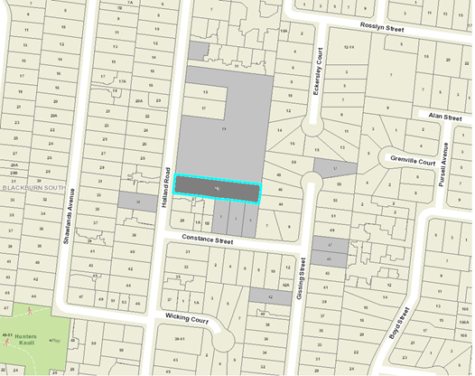
|
|
|
Subject site
|
|
17 Objector Properties
(7
outside of map)
|
é
North
|
BACKGROUND
History
One (1) previous planning permit
application has been lodged and subsequently refused by Council in relation to
the subject site (the site). This is summarised below:
· WH/2008/212
proposed the Use and development of land for a child care centre and display of
business identification signage on the site and was refused by Council on 30th
May 2016, and upheld by VCAT on 6th March 2017.
The Site and Surrounds
The subject site is located on the
eastern side of Holland Road, Blackburn South, approximately 280 metres south
of the intersection with Canterbury Road. The site has a frontage of 21.34
metres to Holland Road, a depth of 94.67 metres along the northern boundary and
94.65 metres along the southern boundary with a site area of 2,020 square
metres. The site is not subject to any easements and no covenants are registered
on title.
The site currently contains a
single storey weatherboard dwelling and carport that is set back approximately
18.5 metres from Holland Road and accessed by a bitumen driveway that runs
parallel to the southern boundary of the site with the crossover located close
to the site’s south western corner. While the site contains no canopy
vegetation on site, there are a number of existing mature trees that adjoin the
perimeter of the site.
The subject site abuts seven
properties that are generally residential in nature. To the south are six
properties comprising three town houses, two single storey brick dwellings and
a double storey dwelling. To the east are two properties that each contain a
single storey brick dwelling. To the north is the Evangelical Chinese Church,
the portion of the site closest to the subject site is predominately car
parking with landscaping along the boundary and a single storey weatherboard
building that is approximately 26 metres from the common boundary. Across
Holland Road to the west is a medium density development comprising four single
storey dwellings.
Planning Controls
The proposal triggers the need for
a planning permit under the following clauses contained within the Whitehorse
Planning Scheme:
Neighbourhood
Residential Zone, Schedule 3 (Clause 32.09)
Pursuant to Clause 32.09-6 of the
Whitehorse Planning Scheme; a permit is required to construct two or more
dwellings on a lot.
Pursuant to Clause 32.09-4 of the
Whitehorse Planning Scheme, a minimum 35% percentage of the land must be set
aside as garden area.
Pursuant to Clause 32.09-9 of the
Whitehorse Planning Scheme, a building must not exceed 9 metres maximum
building height unless the slope of natural ground level measured at any cross
section of the site of the building wider than 8 metres, is greater than 2.5
degrees.
Significant
Landscape Overlay Schedule 9 (Clause 42.03)
Pursuant to Clause 42.03-2 of the
Whitehorse Planning Scheme; a permit is required to remove, destroy or lop a
tree and to construct a building or construct or carry out works within four
metres of a tree protected under this Overlay.
PROPOSAL
The proposal seeks approval for the
Construction of five double storey dwellings, associated front fence and other
works.
In summary, the proposal includes
the following:
· Development
of five (5) double storey dwellings in a ‘tandem’ layout, with
dwellings 2 and 3, and dwellings 4 and 5, each attached by their respective
garages, to the rear of dwelling 1. The dwellings are accessed via a single
driveway located along the southern property boundary.
· The
ground floor internal layout comprises an open plan living/meal/kitchen area,
master bedroom with ensuite and walk-in-robe, laundry and powder room, with 3
additional bedrooms (4 in total), bathroom and retreat room on the first floor.
The exception is dwelling 3 that would not have a ground floor bedroom, and has
a total of 3 bedrooms.
· Dwellings
2, 4 and 5 would have over 150m² of private open space, while dwellings 1
and 3 would have over 60m² of private open space.
· The
materials include a mix of grey face brick, applied grey render, and light grey
timber weatherboard clad to external walls and woodland grey Colorbond roof
sheeting.
In addition to the summary above, the proposal also
provides:
· A
minimum street front setback to Holland Road of 9.09 metres.
· Minimum
side setbacks of 5.75 metres (dwelling 5 garage is exception setback 1 metre)
to the south boundary, and 5 metres from the north boundary.
· Minimum
rear setbacks of 5.05 metres.
· Maximum
total site coverage of 692m² (34.35%).
· Site
permeability of 913m² or 45.19%.
· Garden
Area percentage of 45.19%
· A
maximum build height of 8.74 metres.
CONSULTATION
Public Notice
The original application was
advertised by mail to the adjacent and nearby property owners and occupiers and
by erecting notices to the Holland Road frontage. Following the
advertising period seventeen (17) objections were received.
The issues raised are summarised as
follows:
Neighbourhood Character
· Density
/ Over development
· Scale
/ Built Form / Separation
· Excessive
Site Coverage
· Non-compliant
with Policy
o Clauses
12.05 (Significant Environments and Landscapes), 22.03 (Residential
Development), 22.04 (Tree Conservation), 43.03 (Significant Landscape Overlay -
SLO9)
Appropriate Landscape Outcomes
Needed
· Impact
on Adjoining Trees
· Insufficient
Landscape opportunities
· Adequate
offset for native vegetation loss in past
Traffic / Parking
· Parking
insufficient on and offsite
· Safety
· Noise
Amenity impacts
· Overlooking
/ Privacy
· Overshadowing
· Noise
(vehicles, a/c units)
Drainage (surface water to
adjoining properties)
· High
site coverage
· Raingarden
location
Consultation Forum
A Consultation Forum was held on
Tuesday 27 November 2018. Eleven (11) resident objectors attended the meeting,
in addition to Councillor Munroe, planning officers and the applicant.
The Consultation Forum was chaired
by Councillor Munroe and concerns/objections with the proposal were grouped
under broad categories with all parties afforded the opportunity to provide
commentary on each concern. The permit applicant was also given an opportunity
to respond to objector concerns. A number of potential resolutions were
discussed between parties however no resolutions were reached on the night.
Without Prejudice Plans
Following the advertising period
and Consultation Forum amended site and landscape plans were informally
submitted as ‘Without Prejudice Plans’ seeking to
address issues raised by objections raised where possible. The key changes
include:
Revised Site Plan
· The
visitor parking space between dwellings 1 and 2 moved further north to improve
vehicle manoeuvrability.
· A
second additional visitor parking space between dwellings 3 and 4 (total of
proposed car spaces increased to 12 spaces) to address concerns regarding
parking availability.
· A
new 1.8 metre high boundary fence along part of the southern property boundary
adjacent to properties 1, 3 and 5 Constance Street, as requested by residents.
· The
landscape strip along the south boundary widened to 1 metre to improve space
for landscaping.
· Landscape
areas along the driveway adjacent to dwellings 1 and 2 and opposite the new
second visitor parking space widened to improve space for landscaping.
Revised Landscape Plan:
· Revised
plant species along south boundary to include species with a reduced mature
canopy width of 3 – 3.5 metres to minimise canopy overhang over the
driveway and adjacent properties.
· An
additional landscaping plan note on root control provided to address potential
root damage by the proposed driveway.
· An
additional landscaping plan note on raingarden function to address
neighbours’ concerns on drainage issues.
· Additional
planting provided within widened landscape strips detailed in ‘revised
site plan’ above.
These revised plans were not
readvertised as they are not considered to result in additional detriment to
adjoining owners and/or occupiers, but were circulated to objectors for
additional comment. At the conclusion of this period, additional comments were
received from an existing objector, but introduced no additional objection
grounds to the summarised objection grounds already detailed in this report.
Referrals
External
The proposal was not required to be
referred under section 55 of the Planning and Environment Act 1987.
Internal
|
Transport Engineer
|
Council’s Transport Engineering team have
reviewed the proposal and do not object to the proposal, subject to
recommended conditions relating to vehicular access.
|
|
Waste Engineer
|
Council’s Waste Engineering team have reviewed the
proposal and support the Waste Management Plan subject to the inclusion of
two notes.
|
|
Assets Engineer
|
Council’s Asset Engineering team have reviewed
the proposal and do not object to the proposal, subject to standard
conditions and notes.
|
DISCUSSION
Planning Scheme
State Planning Policy
The construction of five dwellings
on site is consistent with State Planning Policies, which encourage higher
density development within walking distance of shops, recreation facilities and
public transport. The proposal accords with State Planning Policies which
seek to ensure housing stock matches changing demand by widening housing
choice; encourage the development of well-designed medium-density housing that
makes better use of existing infrastructure; and that new development respects
the neighbourhood character and appropriately responds to its landscape, valued
built form and cultural context.
Local Planning
Policy
Local planning policy at Clause
21.05 (Environment) identifies issues of natural, visual and built environment.
Clause 21.06 acknowledges that The City of Whitehorse is a ‘middle
ring municipality providing housing for a wide range of household types, ages
and cultural groups’ and that it is ‘under increased
pressure to accommodate more people who are attracted to the area due to its
strategic location, high amenity residential areas and quality services and
facilities’.
The Council seeks to accommodate
and facilitate this change through its Housing Strategy 2014 and Neighbourhood
Character Study 2014; which identify various neighbourhood character areas
(Bush Environment, Bush Suburban and Garden Suburban) and areas appropriate for
substantial, natural and limited change.
The subject site is located within
a Bush Suburban (Bush Suburban 3) / Limited Change Area. This requires any
design response to respond to the surrounding low scale and detached or
semi-detached dwelling form, whilst recognising key environmental and heritage
attributes.
The proposal responds to these
policy objectives providing for one detached and four semi-detached dwellings,
designed to reflect the scale and size of dwellings that otherwise define the
neighbourhood character. This design provides effective use of the site and
conserves and enhances landscaping opportunities, acknowledging that the site
has been previously cleared of trees and vegetation, whilst providing
space for planting of new canopy trees, a key character and landscape element
of the area.
Specifically, the importance of the
landscape setting and environmental context is achieved through the provision
of an additional fifty (50) trees throughout the site (via new landscaping), of
which thirteen (13) trees will have a minimum height at maturity of at least 12
metres.
It is additionally noted that the
proposed development would reflect an appropriate response to both the
preferred and existing neighbourhood character. With exception of the garage to
dwelling 5, the proposed development seeks to provide for substantive setbacks
from all side and rear boundaries. The proposed development also concentrates
the building footprint centrally within the site allowing for the provision of
generous landscaping and retention of view lines between buildings and built
form elements.
Diversity in floor layout across
the development is acknowledged given the provision of both 3 and 4 bedroom
typologies, while the retention of the existing dwelling is not warranted given
its poor condition.
It is acknowledged that medium
density development is not specifically encouraged within limited change areas
under Clause 22.03. The size and area of this site is however an anomaly at 2,020m²,
given the surrounding smaller lot pattern, which varies between 300m² and
800m². In this instance, the provision of five well separated dwellings
across this relatively larger site would provide a level of housing change
consistent with the objectives and strategies of Clause 22.03 (Residential
Development), within the context of a limited change, Bush-Suburban area.
Neighbourhood Residential Zone
– Schedule 3 (Bush Suburban Areas)
The purpose of the Neighbourhood
Residential Zone is to:
· To
implement the State Planning Policy Framework and the Local Planning Policy
Framework, including the Municipal Strategic Statement and local planning
policies.
· To
recognise areas of predominantly single and double storey residential
development.
· To
manage and ensure that development respects the identified neighbourhood
character, heritage, environmental or landscape characteristics.
· To
allow educational, recreational, religious, community and a limited range of
other non-residential uses to serve local community needs in appropriate
locations.
The proposal is considered to be
consistent with the intent and purpose of the Neighbourhood Residential Zone.
It achieves this by providing detached and semi-attached double storey built
form on a noticeably larger site within the surrounding limited change
residential area. The proposed development also achieves compliance with all
varied ResCode (Clause 55) Standards of the NRZ3 subject to conditions of
approval that will be discussed later in this report. One exception is that
additional windows to dwellings 2 and 4 are required to achieve greater
surveillance through the site.
Notwithstanding, the proposed
development also achieves compliance with the mandatory requirements of the
NRZ, falling below the maximum height limit of 10 metres, and at 45%, providing
more than the minimum garden area requirement of 35%.
Significant Landscape Overlay
– Schedule 9 (SLO9)
The Significant Landscape Overlay
(SLO) is recognised as an important part of the Whitehorse Planning Scheme, and
as such considerable weight is placed upon an application’s ability to
meet the objectives and decision guidelines. The presence of the SLO does not
negate the ability of a site to be developed for residential purposes. However,
the hierarchy of the SLO control does require a more sensitive approach and
places higher levels of expectation on how a site is to respond to built form,
landscape and environmental values.
The SLO9 is generally applied to
limited change areas (Garden Suburban and Bush Suburban Areas). With the site
located within a Bush Suburban Area, the following statement of significance is
outlined below:
‘The Bush Suburban
Neighbourhood Character Area generally has a mix of formal and informal
streetscapes with wide nature strips and streets are dominated by vegetation
with buildings partially hidden behind tall trees and established planting.
Gardens are less formal,
consisting of many canopy trees and property boundary definition can be
non-existent or fenced. Buildings appear detached along the street and
generally comprise pitched rooftops, with simple forms and articulated facades.
The Bush Suburban Neighbourhood
Area includes parts of Blackburn, Box Hill South, Vermont South, Mitcham,
Nunawading and Mont Albert North as shown in the Neighbourhood Character
Precincts Map contained in the Neighbourhood Character Study 2014.’
A number of key decision guidelines must be considered and are
summarised below:
The contribution of the tree to
neighbourhood character and the landscape.
· The
need to retain trees that are significant due to their species age, health
and/or growth characteristics.
· Where
the trees are located, their relationship to existing vegetation and their role
in providing habitat and corridors for fauna and their contribution to local
ecological systems.
· Where
the location of new and existing footings and impervious areas are in relation
to the root zone of established trees.
· The
compatibility of any buildings and works with existing vegetation proposed to
be retained.
· The
effect of any proposed lopping on the significance, health or appearance of the
tree.
· Whether
there is a valid reason for removing the tree and whether alternative options
to removal have been fully explored.
· If
retention cannot be achieved, or a tree is considered appropriate for removal,
consider whether the site provides adequate space for offset planting of
indigenous or native trees that can grow to a mature height similar to the
mature height of the tree to be removed. If it is not appropriate to select an
indigenous or native tree species, the selected species should be drought
tolerant.
· Whether
the planting location of the replacement vegetation will enable the future
growth of the canopy and root system of the tree to maturity.
· Whether
the replacement tree species and planting locations conflict with existing or
proposed overhead wires, buildings, easements and existing trees.
In review of the above, it is
considered that the proposed development is setback a reasonable distance from
property boundaries to provide for a well-conceived landscape design throughout
the site, and provides a good provision of medium and large canopy trees to
contribute to the wider landscape character of the area.
The total site area is 2020m²,
of which 34% is proposed to be taken up by buildings and works and 45% is to be
permeable. This 45% of permeable land is largely provided in the form of
private open space (POS) throughout the development. All areas of secluded
private open space (SPOS) would be located along the site’s side and rear
boundaries and exceed 50m² per dwelling in accordance with Clause 22.04
(Tree Conservation).
As there are no trees that exist on
site, there are no trees that can be retained as part of the proposal, nor are
there any applicable offset requirements that must be addressed. However, there
are a number of established canopy trees that have canopies and potential root
systems that may be within the site. Of these trees, Trees 2 to 11, 13 and 14
all adjoin the site to the north, while Tree 1 (street tree) adjoins the
site’s front boundary.
With exception of a minor
encroachment within the Tree Protection Zone (TPZ) of adjoining Tree 5, there
would be no encroachment of any proposed buildings within the TPZ of any
adjoining tree. Additionally, any encroachment of works (decking, footpath,
earthworks etc) would be minimal and would not compromise the future viability
of any adjoining tree. However, conditions of approval would be added to ensure
that no soil level changes are to occur within the TPZs of these trees to ensure
their viability during the construction period.
Landscaping
Schedule 3 of the NRZ requires the
provision of at least two canopy trees per dwelling that have the potential of
reaching a minimum mature height of 12 metres. At least one of those trees should
be in the secluded private open space of the dwelling, and the species of
canopy trees should be native, preferably indigenous.
In this instance, the revised
landscape plan confirms the provision of at least 2 canopy trees per dwelling,
which are all 12 metres or greater in height. These trees are mostly of native
species (Weeping Lilly Pilly, Lemon Scented gum, Spotted and Brittle or Dwarf
or Brittle Gums, Yellow Box), with some species (Blackwood) being indigenous.
All trees are located within POS or SPOS areas. Overall, the
proposed development seeks to provide for an additional fifty (50) trees
throughout the site, of which thirteen (13) trees will have a height at
maturity of 12 metres or greater;
The proposed overall provision of
landscaping throughout the site is considered to provide for an optimal
landscaping outcome, one which enhances vegetation and landscaping on site
whilst allowing for an appropriate transition between existing (adjoining
trees) and new canopy tree growth throughout site. Further, the extent of
proposed planting will ensure an appropriately landscaped outcome on site
throughout the life of the development. This would be consistent with Clauses
12.05 (Significant Environments and Landscapes), 22.04 (Tree Conservation), Clause
32.09 (NRZ3) and 42.03 (SLO9).
Neighbourhood Character and
Built Form
Neighbourhood Character
The site is located in a Bush
Suburban Neighbourhood Character area pursuant to the City of Whitehorse
Neighbourhood Character Study 2014, and is designated as ‘limited
change’. Specifically, the policy states:
This precinct is identified for
the lowest scale of intended residential growth in Whitehorse (Limited Change
area) and the preservation of its significant landscape character and
environmental integrity is the highest priority.
The proposed development adequately
responds to both the existing and preferred character statement as it seeks to
provide for a mixture of detached and semi-detached townhouse dwellings that do
not exceed two storeys in height.
The use of predominantly brick and
timber materials, coupled with generous setbacks from all boundaries, ensures
that the proposed design response does not dominate the streetscape. The
generous boundary setbacks also provides for substantial landscaping
opportunities throughout the site to visually soften the development to
adjoining properties.
The applicant did however indicate
that the rendered finish cladding to upper floors was currently unconfirmed and
would be up to the builder to determine whether this would be of timber weather
board, brick or a form of light weight panel cladding. This was a concern
raised by residents that the construction of all dwellings must be to a high
standard (i.e. not of light-weight construction). Although this would have no
altered material impact to the amenity of any person given that the external
finish would present as a rendered finish, a condition of approval is to be
included to ensure that the rendered finish be applied upon either brick or
timber weatherboard cladding to address the objection grounds.
The provision of 0.9 metre high
picket fence along the front boundary is considered to be acceptable from a
material, design and height perspective, and would positively contribute to the
streetscape character.
Built Form
The tandem and attached nature of
the proposed design will present as a double storey dwelling when viewed from
street frontage.
The development has been designed
in accordance with all varied ResCode (Clause 55) Standards of the NRZ3
allowing for substantial landscaping opportunities within the front, side and
rear setbacks of site, with minimum setbacks of 9.09 metres (front), 5 metres
(north-side), 5.75 metres (south-side) and 5.05 metres (rear) respectively.
Additionally, the proposal would be below the 10 metre maximum height
requirement under the NRZ and provides for large private open space areas for
all dwellings, respectively exceeding 50m² in area, at minimum widths of 5
metres, located along side and rear boundaries.
The inclusion of a part rendered
finish to the lower sections of the upper floor external walls of dwellings 3
and 5 would provide added visual interest to relieve building mass to side and
rear boundary interfaces. This combined with adequate dwelling separation
between upper floors, along with strong landscaping opportunities across the
site, would result in a proposed development of reasonable scale, height and
bulk from a built form perspective to adjoining properties, the adjacent
streetscape and surrounding area.
Car Parking
Two visitor car spaces have been
provided despite being exempted under Clause 52.06 (Car parking) due to being
located within the Principal Public Transport Network area. Council’s
Transport Engineering Department has supported the proposal subject to conditions
relating to vehicular access both to and throughout the site.
It is also acknowledged that
objection grounds were raised concerning the provision of insufficient onsite
parking given the current traffic congestion and limited on-street parking
circumstances associated with Holland Road. However, given the reasonable scale
of this development, the provision of two additional visitor car spaces would
sufficiently alleviate any potential impact of parking overflow into the
external street network in accordance with Clause 52.06.
It is noted that Council has
received objections concerning the increased parking demand of the development
in conjunction with potentially pedestrian/driver safety. It is firstly
acknowledged that sufficient site line triangles as required by Clause 52.06
are detailed on the plans. Additionally, as the accessway and crossover
would service more than 10 car spaces, a 6.1 metre width passing bay is
required to ensure that traffic flow generated by the development can ingress
and egress the site safely.
It is considered that there is
sufficient frontage width to accommodate a driveway and crossover of double
width, without resulting in any works encroaching into the TPZ of Tree 1.
Consequently, this issue can be addressed as a condition of approval
accordingly.
Clause 22.10 –
Environmentally Sustainable Development
The proposal
triggers the submission of a Sustainability Management Plan (SMP) in accordance
with Clause 22.10. The applicant requested that this requirement be addressed
as a condition of approval, which will be recommended accordingly.
Objectors Concerns not
Previously Addressed
At the Consultation Forum objector
concerns were able to be further explored and elaborated upon. The following
seeks to address those concerns which may not have been adequately addressed or
discussed above.
Amenity Impacts
Concerns have been raised by
objecting parties regarding potential amenity impacts, particularly those of
overlooking, overshadowing and noise. The proposal has been assessed
against relevant ResCode Standards B21 (Overshadowing), Standard B22
(Overlooking) and Standard B24 (Noise Impacts) and is compliant with these
requirements.
Drainage
Council’s Asset Engineering
officer has consented to the proposal subject to a required on-site drainage
detention system being implemented to the satisfaction of Council’s Asset
Engineering officer. This provides certainty that, not only can the existing
drainage network accommodate the additional dwellings proposed, but will ensure
that all surface water drainage can be sufficiently managed on site.
Additionally, a notation on the
revised landscape plan states that rain gardens would collect rainwater
runoff from the driveway and filter impurities whilst slowing peak water flows
to reduce the risk of flooding, with excess water being drained to the internal
drainage system and not into adjacent areas’.
CONCLUSION
The proposed development is
consistent with the relevant planning controls and policies, including the
State and Local Planning Policies and provisions of the NRZ3 and the SLO9. The
proposed development form, siting and overall design is considered to be
acceptable and will integrate well with the existing built form and character
whilst providing for an acceptable landscaping outcome which retains a number
of well-established canopy trees and provide for adequate replacement planting
opportunities throughout the site.
A total of seventeen (17)
objections were received as a result of public notice and all of the issues
raised in these objections have been discussed in this report.
It is considered that the application should be approved
subject to conditions.
Attachment
1 Advertised
Plans ⇨ 
2 Without
Prejudice Plans ⇨ 
9.1.2 7
Patricia Road, Blackburn (Lot 32 PS 11426) Construction of two double storey dwellings
and removal of vegetation
FILE NUMBER: WH/2018/297
ATTACHMENT
SUMMARY
This application was advertised,
following which a total of 14 objections were received. The objections raised
issues with regard to neighbourhood character, amenity, and traffic. A
Consultation Forum was held on 11 October 2018 and chaired by a planning officer
with Councillor Andrew Munroe via teleconference at which all issues were
reviewed.
Draft amended plans were
submitted in response to objector concerns regarding overshadowing. These
plans have not been formally re-advertised as the plans were not formally
lodged and the changes made do not result in additional material detriment to
adjoining owners and occupiers.
This report assesses the
application against the relevant provisions of the Whitehorse Planning Scheme,
as well as the objector concerns. It is recommended that the application
be supported, subject to conditions.
|
RECOMMENDATION
That Council:
A. Being the Responsible Authority, having
caused application WH/2018/297 for 7 Patricia Road, BLACKBURN (Lot 32 PS
11426) to be advertised and having received and noted the objections is of
the opinion that the granting of a Planning Permit for the Construction of
Two (2) Double Storey Dwellings, and Removal of Vegetation is acceptable and
should not unreasonably impact the amenity of adjacent properties.
B. Issue a Notice of Decision to Grant a Permit
under the Whitehorse Planning Scheme to the land described as 7 Patricia
Road, BLACKBURN (Lot 32 LP1142672) for the Construction of Two (2) Double
Story Dwellings, and Removal of Vegetation, subject to the following
conditions:
1. Before
the development starts, or vegetation is removed, amended plans (two full
size copies) must be submitted to and approved by the Responsible
Authority. When approved, the plans will be endorsed and will then form
part of the permit. The plans must be drawn to scale, with dimensions,
and be generally in accordance with the plans submitted with the application
but modified to show:
a) The
locations of Tree Protection Zones described in Condition 5, with all
nominated trees clearly identified and numbered on both site and landscape
plans, and the requirements of Conditions 5 and 6 to be annotated on the
development and landscape plans.
b) A
reduction in the internal floor area to Dwelling 1 to improve vehicle turning
movements for Garage 1. The laundry and storage area reduced in width
by 1.4 metres at the outer edge of the garage to maintain a landscaping
strip.
c) Minimum
garden area of 35% on both development and landscape plans.
d) The
external materials to provide for face brickwork at ground level and a
variation in light-weight materials at upper level to weatherboard or
similar.
e) The
upper level to Dwelling 1 setback 8.42 metres from the front boundary
(allowing for a recession of one metre from the ground floor), without
alteration to any other setback.
f) The
upper level east elevation to Dwelling 1 to achieve a minimum setback of 5.3
metres from the east boundary (allowing for a recession of one metre from the
ground floor below), without alteration to any other setback.
g) Provide
a 0.6 metre freestanding trellis above the height of the existing eastern
boundary fence measured from the Dwelling 2 garage on boundary for a length
of 9.5 metres, to screen the porch and windows of Dwelling 2 ground floor
guest bedroom.
h) Provide
a 0.6 metre freestanding trellis above the height of the existing western
boundary fence (overall combined height of 2.4 metres) for a minimum length
of 34.6 metres from adjacent to the north west corner of the ensuite of
Dwelling 1 to the rear boundary.
i) The
upper level to Dwelling 2 to be setback 3 metres from the western boundary to
the retreat area, without alteration to any other setback.
j) The
Dwelling 1 porch to be no greater than 3.6 metres in height (when measured
from above pre-development ground level) to achieve compliance with Standard
B6.
k) Notation
on site plans indicating that all obscured glazing be manufactured obscured
glass. Obscure film being applied to clear glazing will not be
accepted.
l) New
tree envelopes to generally provide 35 square metres of open ground, not
encroached by water tanks, sheds, clothes line or hard surface areas
and a minimum of 3 metre separation from dwellings.
m) The
grey annotation at the rear of the site over the easement (approximately 45m2)
to be shown as landscaped area consistent with the Design Response TP02 Rev
D, dated 31/10/2018.
n) An
amended landscape plan in accordance with Condition 3.
All of the above requirements must be to the
satisfaction of the Responsible Authority.
Once approved these plans and documents become the
endorsed plans of this permit.
2. The
layout of the site and the size, design and location of the buildings and
works permitted must always accord with the endorsed plan and must not be
altered or modified without the further written consent of the Responsible
Authority.
3. No
building or works are to be commenced (and no trees or vegetation shall be
removed) until a landscape plan prepared by a suitably qualified and
experienced person or firm has been submitted to and endorsed by the
Responsible Authority. This plan when endorsed will form part of this
permit. This plan shall show -
a) A survey
of all existing vegetation, abutting street trees, natural features and
vegetation.
b) Buildings,
outbuildings and trees in neighbouring lots that would affect the landscape
design.
c) Trees
within the development site to be a minimum of 3 metres from buildings within
the site and adjoining properties.
d) Planting
within and around the perimeter of the site comprising trees and shrubs capable
of:
i. Providing
a complete garden scheme,
ii. Softening
the building bulk,
iii. Providing some
upper canopy for landscape perspective,
e) A
schedule of the botanical name of all trees and shrubs proposed to be
retained and those to be removed incorporating any relevant requirements of
Condition 1.
f) The
proposed design features such as paths, paving, lawn and mulch.
g) A
planting schedule of all proposed vegetation (trees, shrubs and ground
covers) which includes, botanical names, common names, pot size, mature size
and total quantities of each plant.
Landscaping in accordance with this approved plan
and schedule shall be completed before the building is occupied.
Once approved these plans become the endorsed
plans of this permit.
4. The
garden areas shown on the endorsed plan and schedule must only be used as
gardens and shall be maintained in a proper, tidy and healthy condition to
the satisfaction of the Responsible Authority. Should any tree or shrub
be removed or destroyed it may be required to be replaced by a tree or shrub
of similar size and variety.
5. Prior
to the commencement of any building and or demolition works on the land, a
Tree Protection Zone (TPZ) must be established on the subject site and
maintained during and until completion of all buildings and works including
landscaping, around the following trees in accordance with the distances and
measures specified below, to the satisfaction of the Responsible Authority:
a) Tree
Protection Zone distances:
i. Street
Tree – 2.0 metre radius from centre of the tree base.
ii. Tree
2 (Pittosporum tennuifolium) – 2.0 metre radius from the centre of the
tree base.
iii. Tree
4 (Syzygium smithii) – 4.2 metre radius
from the centre of the tree base.
b) Tree
Protection Zone measures are to be established in accordance to Australian
Standard 4970-2009 and including the following:
i. Erection
of solid chain mesh or similar type fencing at a minimum height of 1.8 metres
held in place with concrete feet.
ii. Signage
placed around the outer edge of perimeter fencing identifying the area as a
TPZ. The signage should be visible from within the development, with the
lettering complying with AS 1319.
iii. Mulch
across the surface of the TPZ to a depth of 100mm and undertake supplementary
watering in summer months as required.
iv. No
excavation, constructions works or activities, grade changes, surface
treatments or storage of materials of any kind are permitted within the TPZ
unless otherwise approved within this permit or further approved in writing
by the Responsible Authority.
v. All
supports, and bracing should be outside the TPZ and any excavation for
supports or bracing should avoid damaging roots where possible.
vi. No
trenching is allowed within the TPZ for the installation of utility services
unless tree sensitive installation methods such as boring have been approved
by the Responsible Authority.
vii. Where
construction is approved within the TPZ, fencing and mulching should be
placed at the outer point of the construction area.
viii. Where
there are approved works within the TPZ, it may only be reduced to the
required amount by an authorised person only during approved construction
within the TPZ and must be restored in accordance with the above requirements
at all other times.
6. During
the construction of any buildings or works, the following tree protection
requirements must be carried out to the satisfaction of the Responsible
Authority:
a) All
buildings and works for the demolition of the site and construction of the
development (as shown on the endorsed plans) must not alter the existing
ground level or topography of the land within greater than 10% (2.9 metres)
of the Tree Protection Zone of Tree 4.
7. Council's
Compliance Officer must be advised of the completion of all tree planting
required by this permit so that a site inspection can be carried out. A
further inspection will be carried out 6 months after the completion of the
landscaping to ensure that the planting has been adequately maintained.
8. All
external lights must be of a limited intensity to ensure no nuisance is
caused to adjoining or nearby residents and must be provided with approved
baffles, so that no direct light or glare is emitted outside the site.
9. All
stormwater drains and on-site detention systems are to be connected to the
legal point of discharge to the satisfaction of the Responsible Authority
prior to the occupation of the building/s. The requirement for on- site
detention will be noted on your stormwater point of discharge report, or it might
be required as part of the civil plans approval.
10. Detailed
stormwater drainage and/or civil design for the proposed development are to
be prepared by a suitably qualified civil engineer and submitted to the
Responsible Authority for approval prior to occupation of the
development. Plans and calculations are to be submitted with the
application with all levels to Australian Height Datum (AHD). All
documentation is to be signed by the qualified civil engineer.
11. Stormwater
that could adversely affect any adjacent land shall not be discharged from
the subject site onto the surface of the adjacent land.
12. Prior
to works commencing the Applicant/Owner is to submit design plans for all
proposed engineering works external to the site. The plans are to be submitted
as separate engineering drawings for assessment by the Responsible Authority.
13. The
Applicant/Owner is responsible to pay for all costs associated with
reinstatement and/or alterations to Council or other Public Authority assets
as a result of the development. The Applicant/Owner is responsible to
obtain all relevant permits and consents from Council at least 7 days prior
to the commencement of any works on the land and is to obtain prior specific
written approval for any works involving the alteration of Council or other
Public Authority assets. Adequate protection is to be provided to
Council’s infrastructure prior to works commencing and during the
construction process.
14. The
qualified civil engineer when undertaking civil design must ensure that the
landscape plan/s and drainage plan/s are compatible. The stormwater
drainage and on site detention system must be located outside the tree
protection zone (TPZ) of any trees to be retained.
15. This
permit will expire if one of the following circumstances applies:
a) The
development and removal of vegetation is not commenced within two (2) years
from the date of issue of this permit;
b) The
development and removal of vegetation is not completed within four (4) years
from the date of this permit;
The Responsible Authority
may extend the periods referred to if a request is made in writing pursuant
to the provision of Section 69 of the Planning and Environment Act 1987.
Permit Notes
1. The
design and construction of the stormwater drainage system up to the point of
discharge from an allotment is to be approved by the appointed Building
Surveyor. That includes the design and construction of any required
stormwater on-site detention system. The Applicant/Owner is to submit
certification of the design of any required on-site detention system from a
registered consulting engineer (who is listed on the Engineers Australia
National Professional Engineer Register or approved equivalent) to Council as
part of the civil plans approval process.
2. The
requirement for on- site detention will be noted on your stormwater point of
discharge report, or it might be required as part of the civil plans
approval.
3. All
proposed changes to the vehicle crossing are to be constructed in accordance
with the submitted details, Whitehorse Council’s – Vehicle
Crossing General Specifications and standard drawings
4. The
Applicant/Owner is to accurately survey and identify on the design plans all
assets in public land that may be impacted by the proposed development. The
assets may include all public authority services (i.e. gas, water, sewer,
electricity, telephone, traffic signals etc.) and the location of street
trees or vegetation. If any changes are proposed to these assets then the
evidence of the approval is to be submitted to Council and all works are to
be funded by the Applicant/Owner. This includes any modifications to
the road reserve, including footpath, nature strip and kerb and channel.
5. The
Applicant/Owner must obtain a certificate of hydraulic compliance from a
suitably qualified civil engineer to confirm that the on-site detention works
have been constructed in accordance with the approved plans, prior to
Statement of Compliance is issued.
6. There
is to be no change to the levels of the public land, including the road
reserve or other Council property as a result of the development, without the
prior approval of Council. All requirements for access for all-abilities
(Disability Discrimination Access) are to be resolved within the site and not
in public land.
7. No
fire hydrants that are servicing the property are to be placed in the road
reserve, outside the property boundary, without the approval of the relevant
Authority. If approval is obtained, the owner is required to enter into
a Section 173 Agreement with Council that requires the property owner to
maintain the fire hydrant.
8. No
excavation is permitted within the easement.
C. Has made this decision having particular regard to the
requirements of Sections 58, 59, 60 and 61 of the Planning and Environment
Act 1987.
|
Applicant: JKBD
Building Design Consultants
Zoning: General
Residential Zone, Schedule 1 (GRZ1)
Overlays: Significant
Landscape Overlay, Schedule 9 (SLO9)
Relevant Clauses:
Clause 11 Settlement
Clause 15 Built
Environment and Heritage
Clause 16 Housing
Clause 21.05 Environment
Clause 21.06 Housing
Clause 22.03 Residential
Development
Clause 22.04 Tree
Conservation
Clause 32.08 General
Residential Zone, Schedule 1
Clause 42.03 Significant
Landscape Overlay, Schedule 9
Clause 52.06 Car
Parking
Clause 55 Two
or More Dwellings on a Lot
Clause 65 Decision
Guidelines
Ward: Central
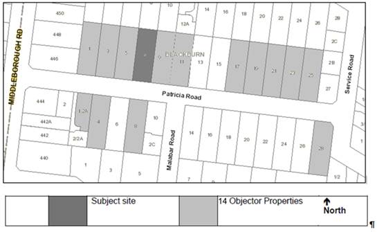
Ward
Location
of objector properties
background
History
· There
is no relevant planning history for the site.
The Site and Surrounds
The subject site is located on the north side of Patricia
Road, approximately 90 metres east of the intersection with Middleborough
Road. The site is rectangular in shape with a frontage of 15.24 metres to
Patricia Street, a depth of 43.43 metres and comprises an area of 662 square
metres. The site has a flat topography and a 3.04 metre wide easement
extends across the rear boundary.
The site currently contains a detached single storey
weatherboard dwelling with tile pitched roofing, setback 7.35 metres from the
Patricia Street frontage. A vehicle crossover, driveway and a double
garage/shed are located adjacent to the east boundary. The
applicant’s arborist report provides an assessment of 12 trees within the
site (with tree 4 straddling the rear common boundary). The trees are a mix of
low to medium retention value with Trees 1, 2, 3, 4, 5, 8, 10 and 11 protected
under the Significant Landscape Overlay, Schedule 9. There are no trees
on adjoining lots in the vicinity of the subject land.
The surrounding properties contain single storey
weatherboard dwellings with some double storey dwellings evident within
Patricia Road (2, 16 and 20 Patricia Road). Nearby medium density infill
developments are primarily single storey built form. However, there are
contemporary double storey medium density developments at 8 Stanley Grove (two
double storey dwellings), 12 and 15 Tyrrell Avenue (three, double storey
dwellings) and 465 Middleborough Road (three double storey dwellings).
The Laburnum train station is approximately 1 km from the
site and a bus stop (Route 279) is approximately 40 metres from the site.
Planning Controls
The proposal triggers the need for a planning permit under
the following clauses contained within the Whitehorse Planning Scheme:
General Residential Zone, Schedule 1 (Clause 32.08)
Pursuant to Clause 32.08-6 of the Whitehorse Planning
Scheme; a permit is required to construct two or more dwellings on a lot.
Significant Landscape Overlay (Clause 42.03)
Pursuant to Clause 42.03-2 of the Whitehorse Planning
Scheme; a permit is required to remove, destroy or lop a tree and to construct
a building or construct or carry out works within 4 metres of protected
vegetation.
PROPOSAL
The proposal seeks approval for the
construction of two (2) double storey dwellings and removal of vegetation.
In summary, the proposal includes
the following:
· The
dwellings are attached, arranged in a ‘tandem’ layout and
accessible via a single driveway located along the site’s eastern
boundary. The existing crossover will be reconstructed.
· The
dwellings provide for an open plan kitchen, living and dining area, master
bedroom (with ensuite and WIR) and laundry at ground level and three bedrooms
(one with ensuite and WIR), bathroom and retreat room at first floor
level. Each dwelling is provided with a double garage, with the garage to
Dwelling 2 attached to the east boundary.
· Dwelling
1 is setback 7.42 metres to the Patricia Street boundary with the upper level
setback a minimum of 7.92 metres. The dwellings achieve varying setbacks
throughout the site with a minimum of 1 metre to the west boundary and 3 metres
to the rear boundary at ground level.
· External
materials include rendered polystyrene cladding at ground and first floor with
beige and grey colour tones.
· A
1.2 metre high front fence that comprises rendered piers with horizontal timber
slats.
· Maximum
total site coverage of 42.4%.
· Site
permeability of 37%.
· Garden
Area percentage of 35%
· A
maximum build height of approximately 7.52 metres.
· Removal
of all trees from the subject site except for Trees 2 and 4. A summary table of
the protected trees to be removed is provided below:
|
Tree No
|
Botanical Name
|
Common Name
|
Height (m)
|
Age (year)
|
|
Tree 1
|
Betula pendula
|
Silver Birch
|
8m
|
Semi mature
|
|
Tree 3
|
Pyrus species
|
Pear
|
12m
|
Mature
|
|
Tree 6
|
Callistemon viminalis
|
Callistemon
|
7m
|
Semi-Mature
|
|
Tree 8
|
Malus domestica
|
Apple
|
5
|
Senescent
|
|
Tree 10
|
Acer palmatum
|
Japanese Maple
|
7
|
Semi-mature
|
|
Tree 11
|
Acer planatioides
|
Sycamore Maple
|
9
|
Senescent
|
· A
summary of the protected trees to be retained are listed as follows:
|
|
Botanical Name
|
Common Name
|
Height (m)
|
Age (year)
|
|
Tree 2
|
Pittosporum tennuifolium
|
Pittosporum
|
6
|
Semi-mature
|
|
Tree 4
|
Syzygium smithii
|
Lillypilly
|
12m
|
Semi-mature
|
· Replacement
planting of five (5) trees with a height at maturity of 6 to 8 metres.
These species include two Eucalyptus leucoxylon – Euky Dwarf, two Pyrus
nivalis – Snow Pear and one Hymenosporum flavum –Native
Frangipani
CONSULTATION
Public Notice
The application was advertised by
mail to the adjacent and nearby property owners and occupiers and by erecting
notices to the Patricia Road frontage. Following the advertising period
fourteen (14) objections were received.
The issues raised are summarised as
follows:
Neighbourhood Character
· Bulk
and Massing
· There
are no properties with two double storey residences in Patricia Road.
· The
development would set a precedent.
Traffic and Car Parking
· Traffic
Impacts along Patricia Road
Amenity impacts
· Overlooking
· Overshadowing
/ loss of sunlight (energy efficiency to existing solar)
Other
· Incorrect
documentation advertised.
This was resolved by notification of the correct arborist
report, noting development plans were correct.
Consultation Forum
A Consultation Forum was held on 11
October 2018. Nine parties attended the meeting, in addition to Cr Munroe
via teleconference, planning officers and the applicant.
All objector parties were given the
opportunity to comment on each concern. The permit applicant also responded to
objector concerns. A number of potential resolutions were discussed between
parties, however no resolution was reached at the forum
Subsequent to the Consultation
Forum amended plans were submitted but not formally lodged, seeking
to address issues raised by referrals and objections where possible.
The key changes include:
· Plans
updated to show the glazing to the northern elevation of the neighbouring
property.
· The
plans show the existing shadows and proposed shadows at 10am and 11am for the
22 September and 21 June. It is noted that the plans demonstrate that the
overshadowing does not affect the solar panels of 5 Patricia Road and any
overshadowing is minimal after 11am.
· The
plans include a cross section drawing to demonstrate the overshadowing to 5
Patricia Road to the north facing windows. It is also noted that the
covered area of 5 Patricia Road currently overshadows the north facing
windows.
A copy of the plans were emailed to
all objectors on the attendance list who provided email contact details.
Referrals
Internal
Engineering and Environmental
Services Department
· Transport
Engineer
The application was referred to Council’s Transport
Engineering team who have reviewed the proposal and do not object, subject to
conditions relating to vehicular access throughout the site. This
includes reducing the laundry storage area by 1.4 metres and altering the
landscaping accordingly adjacent to Dwelling 1. The condition will
require some soft landscaping edge.
· Assets
Engineer
The application was referred to
Council’s Asset Engineering team do not object to the proposal, subject
to standard conditions.
ParksWide
Council’s ParksWide Team have
advised that as the street tree is 3 metres from the proposed crossover there
will be no impact. The proposed new fence will be 4 metres from the tree
and will also not have any impact as it is outside its TPZ.
Planning Arborist
The application was referred to Council’s Planning
Arborist who has reviewed the proposal and does not object to the proposal
subject to standard conditions relating to protection and retention of two
canopy trees on site.
DISCUSSION
Planning Scheme
State Planning Policy
The construction of two dwellings on site is consistent with
State Planning Policies, which encourage higher density development within
walking distance of shops, recreation facilities and public transport. Clause
16 (Housing) facilitates housing diversity, opportunities for increased supply
and activate underutilised land in locations close to jobs, services and public
transport. Clause 11 (Settlement) anticipates the needs of communities through
land zoned for housing diversity and economic viability while maintaining good
amenity and a protected environment. Patricia Road is suitably located in the
middle ring of Metropolitan Melbourne, in an area close to CBD employment and
the lot is of a reasonable size to facilitate medium density development.
The proposal also accords with State Planning Policies which
seek to ensure housing stock matches changing demand by widening housing
choice; encourage the development of well-designed medium-density housing that
makes better use of existing infrastructure; and that new development respects
the neighbourhood character and appropriately responds to its landscape, valued
built form and cultural context.
Local Planning Policy
Local planning policy at Clause 21.05 (Environment)
identifies issues of natural, visual and built environment. Clause 21.06
acknowledges that The City of Whitehorse is a ‘middle ring
municipality providing housing for a wide range of household types, ages and
cultural groups’ and that it is ‘under increased pressure to
accommodate more people who are attracted to the area due to its strategic
location, high amenity residential areas and quality services and facilities’.
The Council seeks to accommodate and facilitate this change
through its Housing Strategy 2014 and Neighbourhood Character Study
2014; which identify various neighbourhood character areas (Bush
Environment, Bush Suburban and Garden Suburban) and areas appropriate for
substantial, natural and limited change. The subject site is located within
a Garden Suburban/Natural Change Area. This requires any design response to
respond to the surrounding low scale and detached or semi-detached dwelling
form, whilst recognising key environmental and landscape attributes.
The proposal responds to these policy objectives in that it
provides for two dwellings, arranged one behind the other, designed to reflect
the scale and size of dwellings that otherwise define the neighbourhood
character. This design provides effective use of the site and conserves and
enhances landscaping opportunities, retention of trees at the rear of the site,
whilst providing space for planting of new canopy trees, a key character and
landscape element of the area.
It is also noted that the proposal provides for new
development on the site which reflects an appropriate response to both the
preferred and existing neighbourhood character as it seeks to provide for
acceptable setbacks at ground level from all side and rear boundaries,
concentrates the building footprint centrally within the site allowing for the
provision of sufficient landscaping and retention of view lines between
buildings/built form.
General Residential Zone – Schedule 1 (Established
Garden Suburban Areas)
The purpose of the General Residential Zone includes:
· To
implement the Municipal Planning Policy Framework and the Planning Framework.
· To
encourage development that respects the neighbourhood character of the area.
· To
encourage a diversity of housing types and housing growth particularly in
locations offering good access to services and transport.
The proposal is considered to be consistent with the intent
and purpose of the General Residential Zone. It achieves this by contributing
to urban consolidation, adding to housing diversity types in a double storey
built form while providing for replacement tree planting. The proposed
development also achieves compliance with all varied ResCode (Clause 55)
Standards of GRZ1.
Significant Landscape Overlay – Schedule 9 (SLO9)
The Significant Landscape Overlay is recognised as an
important part of the Whitehorse Planning Scheme, and as such weight is placed
upon an application’s ability to meet the objectives and decision
guidelines. The presence of the SLO does not negate the ability of a site
to be developed for residential purposes, however the introduction of the
interim control does require a more sensitive approach and places higher levels
of expectation on how a site is to respond to built-form, landscape and
environmental values.
Schedule 9 deals with ‘Neighbourhood Character
Areas’ whereby the statement identifies ‘trees as being
significant to the landscape character of Whitehorse and the tree cover
simultaneously delivers multiple benefits to the community, including defining
neighbourhood character, providing visual amenity, reducing the urban heat
island effect in more urbanised areas, improving air quality and energy
efficiency, providing habitat for fauna, increasing the wellbeing of people and
liveability of neighbourhoods’.
The Garden Suburban Neighbourhood Character Areas are ‘typically
established with canopy trees, lawn areas, garden beds and shrubs and there are
typically well defined property boundaries and consistent building
siting’.
A number of key decision guidelines must be considered and
are summarised below:
· The
contribution of the tree to the neighbourhood character and landscape.
· The
need to retain trees that are significant due to their species age, health and
/ or growth characteristics.
· If
retention cannot be achieved or a tree is considered appropriate for removal,
consider whether the site provides adequate space for offset planting of
indigenous or native trees that can grow to a mature height similar to the
mature height of the tree to be removed. If it is not appropriate to select an
indigenous or native tree species, the selected species should be drought
tolerant.
The trees identified for removal have been assessed as
having poor health/poor structure and are of low significance. Council’s
Arborist has undertaken an inspection of the site and reviewed the proposed
development and accompanying Arborist Report and does not dispute the
assessment for removal of these trees.
In review of the above, it is considered that the proposed development
offers setbacks from property boundaries that provide for an acceptable
landscape design throughout the site, which both ensures adequate retention of
the two trees at the rear, new tree planting of five trees, 72 complementary
shrubs, and 89 ground covers.
The total site area is 662sqm, of
which 42.4% is proposed to be taken up by buildings and 37% is to be permeable.
This permeable land is largely provided in the form of private open space and
secluded private open space throughout the development. The areas of secluded
private open space are 35 and 64 square metres for Dwellings 1 and 2
respectively, and allows for the planting of at least one tree within the rear
yard. In accordance with the Performance Standards of Clause 22.04 (Tree
Conservation), it is recommended that new trees be located at least three
metres from buildings, to be consistent with the policy and provide for optimal
growing conditions. The proposal can achieve this through conditions.
Neighbourhood Character and
Built Form
Neighbourhood Character
The site is located in
Neighbourhood Character Precinct Garden Suburban 13, in a designated area of
natural change. Specifically, the preferred character statement (Garden
Suburban 13) requires:
A variety of well articulated dwelling
styles will sit within compact garden settings. Infill development will be
common, however new buildings and additions will be setback at upper levels to
minimise dominance in the streetscape. The consistent front setbacks and
spacing between dwellings will be retained, with buildings setback or appearing
to be setback from at least one side boundary. Low or open style front fences
will provide a sense of openness along the streetscape, and allow views into
front gardens.
The proposed development adequately
responds to both the existing and preferred character statement as it seeks to
provide for two dwellings which do not exceed two storeys in height. The
setbacks from all boundaries ensure that the proposed design response does not
dominate the streetscape and provides for retention of existing vegetation on
site and landscaping opportunities throughout. The proposed external
cladding material is rendered polystyrene cladding with minimal variation in
colour finishes. However to better complement the established built form
character, it is recommended that the dwellings feature face brickwork at lower
level with some further variation in light-weight material at first floor level
(in addition to render).
The provision of two (2) trees
within the site’s frontage will assist in screening the proposed
development from the street frontage, with this to be further enhanced with
landscape planting along both side boundaries of the site.
At present the proposal has a
separate garden area plan, a condition of permit will require the minimum
garden area of 35% to be shown on both the development and landscape plans to
ensure this is achieved.
The provision of a 1.2 metre high
pier and timber batten front fence along the site’s frontage, is
consistent with the height of fencing found within the streetscape. Its
design is relatively unobtrusive in nature given its materiality (timber
batten) and design (containing of spacing between battens). The design of
the fence also maintains views into the front setback.
Built Form
Prior to notice in response to matters raised by officers,
amended plans were submitted including an improvement of the first floor
recession from the south and west boundaries. These advertised plans had
the upper level to Dwelling 1 setback 7.92 metres (an increase of 500mm from
the ground floor below) from the front boundary and the upper levels to the
west setback a minimum of 2.1 metres ensuring compliance with Standard
B17. While an improved outcome, the overall building recess is still not
considered sufficient, as there remain elements of the upper levels that
present visual bulk to adjoining properties SPOS. In addition, alteration
to the ground floor footprint to address traffic concerns requires replacement
of lost landscape areas. It is considered that further refinement of the
proposed development to produce an acceptable outcome can be addressed through
conditions of the permit, including:
· The
upper level to Dwelling 1 is to be setback 8.42 metres from the front boundary
(allowing for a recession of one metre from the ground floor below).
· The
upper level east elevation to Dwelling 1 to achieve a minimum setback of 5.3
metres from the boundary (allowing for a recession of 1.0 metre from the ground
floor below). This will significantly improve the level of recession at
this interface which is clearly visible from the common property
driveway.
· Dwelling
2 to be setback 3 metres from the western boundary (retreat area).
· The
Dwelling 1 porch to be no greater than 3.6 metres (when measured from above
pre-development ground level) to ensure it is compliant with Standard B6 and
not a dominant element when viewed from the streetscape.
Once the development provides these further changes, it will
reduce its visual bulk, particularly at the upper level. Other positive
elements of the built form include:
· The
development only proposes one wall adjacent to the east boundary. The
wall is significantly recessed into the site to minimise its visibility from
the streetscape and is located directly opposite a garage located within the
rear yard of 9 Patricia Road.
· The
development relies on a single vehicle crossover, with car accommodation
otherwise recessed into the site. This layout ensures car accommodation
does not dominate the streetscape and allows opportunity for a strong
landscaping response across the site’s frontage.
· Although
the development is attached at ground level, the upper levels achieve a
significant separation of 6.4 metres, allowing for permeable views through the
centre of the site.
Car Parking
The proposal meets the requirements
of Clause 52.06 (Car parking) Council’s Transport Engineering Department
supports the proposal subject to conditions relating to vehicular access to
Dwelling 1.
Additionally it is noted, that
Council have received objections around the parking impact to Patricia Road.
The development is not considered to result in traffic conflict or reduce
safety outcomes.
Objectors Concerns not
Previously Addressed
The following seeks to address
those concerns which may not have been adequately addressed at the Consultation
Forum or discussed above.
Energy efficiency (Standard B10)
The objector (at 5 Patricia Road) raised concerns regarding
impact of the proposed development on existing solar efficiency of the solar
hot water system. The planning scheme was amended on 26 October 2018, while the
application was under assessment, to include additional provisions under Standard
B10. The provision states,
Buildings should be sited and designed to ensure that the
performance of existing rooftop solar energy facilities on dwellings on
adjoining lots in a General Residential Zone, Neighbourhood Residential Zone or
Township Zone are not unreasonably reduced. The existing rooftop solar energy
facility must exist at the date the application is lodged.
The applicant has provided additional shadow diagrams (See
Attachment 2) and cross-section was provided to demonstrate overshadowing to
north facing windows between 7am-11am on 22 September (TP 13). The shadow
diagrams have indicated that there will be some shadow cast on the solar hot
water system at 9 am at the equinox and until 11am at the winter
solstice. As impact upon the hot water system is for a limited portion of
the day it is therefore considered to be reasonable.
North facing windows
The objector raised concerns regarding the
impact of the proposed development on solar access to existing north facing
windows. An assessment was undertaken of the existing conditions and proposed
development impact. Although a north facing window on an abutting dwelling (at
5 Patricia) has partial overshadowing for part of the equinox assessment period
the amount of shadowing is not considered to be excessive.
Neighbourhood character
All objectors have raised concerns relating to double storey
height impinging on adjacent single storey development, which disrupts the
established streetscape character. The context surrounding the subject
site reflects a mix of building and architectural styles that are single and
double storey in scale. There is an emerging trend with replacement of
original houses with large two storey family homes. The proposed
development does not represent an unreasonable response in this regard.
Amenity Impacts
Concerns have been raised by
objecting parties regarding potential amenity impact, particularly those of
overlooking, overshadowing and noise.
The proposal has been assessed
against relevant ResCode Standards B21 (Overshadowing) and complies. The
elevations demonstrate ground floor overlooking and requires trellis screening
above boundary fencing to comply with Standard B22 (Overlooking). Any concerns
regarding noise are governed through the EPA if above what is considered above
the levels of noise usual for a residential property.
Precedent
The development of two dwellings
per lot is not an uncommon occurrence within the wider area with a number of
existing lots developed with multi dwellings. The zoning of the land also
supports a modest increase in dwellings, provided it respects the neighbourhood
character of the area. This development is not considered to set any
unreasonable precedence.
CONCLUSION
The proposed development is consistent with the relevant
planning controls and policies, including the State and Local Planning Policies
and provisions of the GRZ1and the SLO9. The proposed development form, siting
and overall design is considered to be acceptable and will integrate well with
the existing built form and character whilst providing for an acceptable
landscaping outcome. Further, the proposal retains two mature canopy trees and
provides for adequate replacement planting opportunities throughout the site.
A total of 14 objections were received as a result of public
notice and all of the issues raised in these objections have been discussed in
this report.
It is considered that the application should be approved
subject to conditions.
Attachment
1 Advertised
Plans ⇨ 
2 Additional
Shadow Diagrams ⇨ 
Ordinary Council Meeting 29
January 2019
Strategic
Planning
9.1.3 Residential
Corridors Built Form Study - Consultation outcomes and recommended built form
controls
ATTACHMENT
SUMMARY
Council engaged planning consultants Ethos Urban to
undertake the Residential Corridors Built Form Study (the Study). The Study
provides built form guidelines for those areas in the municipality along key
road corridors. The Study has included background analysis of existing
development, planning permits, VCAT cases, site visits and two rounds of
community engagement.
This report provides a summary of the community engagement
results and discusses the recommended built form controls based on the project
work and community consultation. This report also recommends that the Study be
adopted and that Council seek authorisation from the Minister for Planning to
implement the Study through a planning scheme amendment.
|
RECOMMENDATION
That Council:
1. Adopt
the Draft Residential Corridors Built Form Study at Attachment 1.
2. Seek
authorisation from the Minister for Planning under the Planning and
Environment Act 1987 (Section 8a) to prepare and exhibit an amendment to the
Whitehorse Planning Scheme to implement the recommendations of the Study.
3. Advise
all submitters to the Residential Corridors Built Form Study consultation of
this resolution.
|
background
Council engaged planning
consultants Ethos Urban in late 2017 to undertake the Residential Corridor
Built Form Study, which was a new budget initiative in the 2017/2018 Council
budget.
The Study produced draft built form
guidelines for those areas in the municipality along key road corridors where
land in the Residential Growth Zone (RGZ) interfaces with land in the
Neighbourhood Residential Zone (NRZ) and the General Residential Zone (GRZ).
The Study has focused primarily on
the major east-west tram and road corridors, where there is an interface
between the RGZ and GRZ or NRZ to the rear or side. Specifically, the
Study has looked at:
· Burwood
Highway, generally between Elgar Road, Burwood and Hanover Road, Vermont South
· Whitehorse
Road in Mont Albert, Laburnum and Nunawading.
The study areas include existing
activity centres such as Box Hill, Burwood Heights and Tally Ho for context,
but any proposed outcomes will not apply to the activity centres where they are
the subject of existing structure plans and/or built form controls.
Ethos Urban presented to Council on
three occasions during the project:
· 5
March 2018: this session provided an overview of the project including
background analysis of existing development, planning permits and Victorian
Civil and Administrative Tribunal (VCAT) cases, as well as an introduction to
good design that could occur in the study area.
· 12
June 2018: this presentation sought endorsement of the draft built form
guidelines for community engagement. At the Council Meeting on 25 June 2018
Council resolved to endorse the draft guidelines for community engagement.
· 15
October 2018: this session provided an overview of the community engagement
outcomes and the final recommended built form controls. The response to community
feedback is discussed under ‘Consultation’ below.
DISCUSSION
The consultants have produced a
final draft document detailing the study area, strategic and statutory context,
case study examples, review of permits and VCAT decisions, the impact of Clause
58 (Apartment Developments) of the planning scheme and emerging issues. The
final draft document is available at Attachment 1 and includes a vision,
design principles / objectives and recommended built form outcomes. The final
draft document also summarises the community engagement outcomes, urban design
principles, built form testing, recommended built form controls and where the
proposed controls are intended to apply.
Recommended built form controls
The recommended controls on built form can be summarised as
follows:
|
Built form element
|
Measure
|
Built form outcomes
|
|
Height
|
4
storeys (13 metres) preferred maximum east of Springvale Road, on Burwood
Highway*
5
storeys (16 metres) preferred maximum elsewhere
6
storeys (19 metres) mandatory maximum in all locations
|
The maintenance of a mid-rise
scale of development.
To enhance the sense of openness,
maintain access to sky views and maximise solar access from/to the low scale
residential development of the adjacent areas.
The visual impact of taller buildings,
above the preferred building height, is alleviated through increased upper
level setbacks.
|
|
Front setback
|
Minimum
5 metres with an additional 3 metres to upper levels above 4 storeys (total
of 8 metres) mandatory
|
Buildings are setback from the
front boundary to:
· ensure they do
not visually dominate the streetscape
· provide adequate
sun penetration at street level
· assist with
mitigating wind down-draughts
· provide for
landscaping in the frontage.
|
|
Built form element
|
Measure
|
Built form outcomes
|
|
Side setbacks
|
Minimum
of 4.5 metres with an additional 4.5 metres to upper levels above 4 storeys
(total of 9 metres) mandatory
|
Buildings are setback from the
side boundaries to:
· provide adequate
sunlight, daylight, privacy and outlook from habitable rooms, for both
existing and proposed developments
· provide adequate
daylight and sunlight to streets
· ensure buildings
do not appear as a continuous wall at street level or from nearby vantage
points and maintain open sky views between them
· provide for
landscaping between buildings.
|
|
Rear setbacks
|
Minimum
of 9 metres mandatory
|
Buildings are setback from the
rear boundary to:
· provide adequate
sunlight, daylight, privacy and outlook from habitable rooms, for both
existing and proposed developments
· ensure they do
not visually dominate or compromise the character of adjacent existing
low-scale development areas
· provide space
for a large tree canopy and assist with a visual break between the lower
scale built form of the adjacent areas outside of the RGZ.
|
|
Pedestrian interfaces
|
Buildings
at ground floor must present attractive pedestrian orientated frontages.
|
Buildings should ensure that the
ground floor frontages add visual interest and contribute to the street.
Access to car parking and service
areas should not dominate street frontages.
Windows at ground level should be
maximised to provide passive surveillance.
Visible service areas (and other
utility requirements) should be treated as an integral part of the overall
building design and fully screened from public areas.
|
|
Built form element
|
Measure
|
Built form outcomes
|
|
Shadowing
|
No
significant shadowing to adjacent public open space between 12.00pm and
2.00pm on 22 September.
|
Additional overshadowing of
adjoining open space will only be considered appropriate where:
· the area of
remaining sunlit space exceeds the area of shadowed space
· there is no
adverse impact on the natural landscape, including trees and lawn or turf
surfaces in the public space
· the existing and
future use, quality and amenity of the public space is not compromised.
|
|
Wind effects
|
Developments
over 4 storeys in height must be accompanied by a wind tunnel assessment (mandatory).
|
The wind analysis must:
· explain the
effect of the proposed development on the wind conditions in publicly
accessible areas
· model the wind
effects of the proposed development and its surrounding buildings
· determine that
the development will not cause unsafe wind conditions in publicly accessible
areas.
|
|
Landscaping
|
Provide
for a minimum deep soil area relative to tree height which is between 800mm
deep (for small trees) and 1200mm deep (for large trees).
|
Ensure the green character of the
area is enhanced with deep soil plantings in the front, side and rear
setbacks.
Utilise appropriate plant species
in accordance with Council guidelines.
|
*Note: Developments of 4 storeys and under are required
to comply with ResCode.
Rationale for the proposed
height and setback controls
The proposed building heights
are based on analysis of approved developments, VCAT decisions and the impact
of the Apartment Design Guidelines (Clause 58 of the planning scheme) on higher
density development. As an example, Clause 58 requires apartments to have a
certain room depth (maximum 9 metres) based on access to daylight which results
in narrow building floorplates. As a result of narrow floorplates and a smaller
number of apartments per floor, applicants seek taller, slimmer apartment
forms.
It is proposed to have a preferred
maximum height of 4 storeys along Burwood Highway east of Springvale Road,
Vermont South. This is recommended to maintain a sense of openness and access
to the sky views along the road corridor towards the Dandenong Ranges and
maximise solar access from/to the low scale residential development of the adjacent
NRZ areas.
The background analysis reviewed
lot sizes as well as the composition of development parcels and identified that
site consolidation is occurring along the corridors. Site consolidation usually
occurs where a single site does not have a depth or width that would allow for
development to meet the requirements of the planning scheme and therefore
multiple sites are joined together to allow this outcome. The built form
testing demonstrated that site consolidation would be required to pursue heights
of 6 storeys. However the analysis undertaken also identified that there are
limited opportunities for this to occur.
The proposed street setbacks
are based on the average setback of permits issued which were analysed as part
of this study. The consultants contend that the street setbacks are consistent
with Clause 22.04 Tree Conservation Policy in the planning scheme by providing
space for trees. This will also allow for increased tree planting, assist with
mitigating wind down-draughts, provide adequate sun penetration at street level
and ensure buildings do not visually dominate the streetscape.
The proposed side and rear
setbacks are based on the desired future character of the area, including
the vegetation character. The buildings will be set back to provide visual
separation between built form elements reflecting the typical rhythm of the
streetscapes and provide sufficient planting for new vegetation.
The proposed side setbacks are also
based on the case study examples contained within the draft report,
particularly Amendment C159 to the Moreland Planning Scheme, which introduced a
mandatory side setback of 4.5 metres and internal amenity considerations
required now under Clause 58.
The proposed rear setbacks
are based on the need to ensure adequate planting and to alleviate overlooking
of neighbouring properties. The permit data reviewed as part of this study
revealed a number of applications where the upper levels extend into the
setback of 8.6 metres sought under ResCode in Clause 55.04 (Standard B17). By
contrast a single rear setback will assist in alleviating visual bulk as a
stepped form can be more dominating than an element which is setback further
and allows for large canopy trees. The smaller front street setbacks allows for
greater setback at the sensitive interfaces.
The study ultimately recommends
that a design and development overlay (DDO), incorporating the above
standards, will provide guidance to assess applications that seek to exceed the
preferred height. Guidance in the overlay will ensure that careful
consideration and regard to amenity impacts (such as wind effects,
overshadowing) and contextual built form response is given, including
relationship to the scale of the surrounding area.
Officers recognise that,
historically, it has been difficult to obtain approval from the Minister for
Planning for mandatory planning scheme controls, specifically mandatory height
controls. Notwithstanding this appreciation, the study identifies mandatory
controls have been applied elsewhere in metropolitan Melbourne, including in
Moreland (December 2017) and Darebin (September 2016).
Mandatory heights and setback
controls were introduced in 8 of Moreland’s Neighbourhood Activity
Centres in a range of zones including the RGZ. Mandatory heights up to 6
storeys were also introduced along corridors in Darebin, also in a range of
zones including the RGZ.
Whilst the decision to approve any
mandatory controls ultimately lies with the Minister for Planning, the
consultants believe that the study includes the relevant evidence to seek the
application of mandatory controls as outlined above. This includes support for
a preferred (discretionary) height limit of 4 storeys on Burwood Highway east
of Springvale Road and a maximum (mandatory) height limit of 6 storeys across
all of the areas.
Application of controls
The study area for the project
includes the RGZ land generally along the two major east-west corridors –
Whitehorse Road and Burwood Highway.
The study area includes properties
beyond the corridor for context and consideration, however any new built form
controls that arise from the study are only intended to apply to the RGZ
outside of the Tally Ho, Burwood Heights and Box Hill activity centres. These
areas have guidance from existing Structure Plans, Urban Design Frameworks or
Guidelines and/or existing overlay controls. Any controls that arise from the
Study will also not apply to commercially zoned properties along the corridors.
The site at 490-506 Whitehorse
Road, Mitcham (St John’s primary school) is also not proposed to be
included in any controls at this time as it is within the core of the future
Nunawading/MegaMile Major Activity Centre and Mitcham Neighbourhood Activity
Centre Structure Plan review area. Residential Growth Zoned land in Study Area
3, on Whitehorse Road between Springvale Road Peel Street, Mitcham, is however
included.
Additionally, it is not intended
for any new controls to apply to the ARRB site at 490-500 Burwood Highway,
Vermont South. This site is undergoing a separate process and any future height
on this site will consider the Residential Corridors Built Form Study and
neighbouring development context.
It is therefore recommended that
the overlay is applied to land in the RGZ fronting Whitehorse Road and Burwood
Highway, excluding those sites already noted above.
Developments of 4 storeys and under
are required to comply with ResCode requirements found at Clause 54 and Clause
55 of the Planning Scheme. The overlay is not intended to contradict the
existing ResCode requirements and therefore the built form controls are
proposed to apply to developments that are 5 storeys and above. The consultants
contend that better outcomes will be realised, particularly relating to
vegetation and planting, for developments above 5 storeys that would be
required to consider the proposed controls (such as increased rear building
setbacks).
The Study found that there will be
no impact to the proposed housing capacity as identified in the Housing and
Neighbourhood Character Study 2014. Conversely, most of the case studies in the
draft report result in a higher yield when the proposed controls are applied as
they are recommending a greater height than the 3 and 4 storeys which Council put
forward as part of Amendment C160 (new residential zones).
The proposed overlay will not
consider issues such as car parking as this is covered elsewhere in the
Planning Scheme (Clause 52.06) and was outside the scope of this study.
Regarding concerns about access to more intensive residential developments from
side streets, Whitehorse Road and Burwood Highway are under the jurisdiction of
VicRoads which typically does not allow additional access from its roads to
private properties. VicRoads usually requests any access to be from minor
roads. Officers appreciate the complexities around traffic and car parking,
especially given the recent gazettal of an amendment to the Victoria Planning
Provisions (VC148) which reduced car parking requirements for land within 400m
of the Principal Public Transport Network Area. In particular it reduced the
number of visitor car parking spaces required for a development.
A DDO will need to be implemented
through a planning scheme amendment. This would require drafting of the
planning controls before seeking authorisation from the Minister for Planning
to prepare and exhibit a new amendment to the Whitehorse Planning Scheme.
CONSULTATION
The project was introduced to the
community within the study area in late March 2018 through the distribution of
a newsletter, which included information about the project, including the aims,
study area and where to find further information. The project was also
advertised in the Whitehorse Leader and through a project webpage on the Council
website.
This phase of the project included
a short survey to identify what resident’s value about their area. The
survey responses were collated as part of the background analysis.
The second phase of community
engagement was held from mid-July to mid-August 2018. This phase included
notification to all owners and occupiers within the study area, as well as
those who nominated to be on the project mailing list. Notification also
involved advertising in the Whitehorse Leader and updating the project webpage.
Two drop-in information sessions
were held during phase two: one in the northern part of the municipality and
one in the southern part of the municipality. The drop-in sessions were staffed
by Council officers and the consultants and allowed interested parties to
discuss the project and draft options. 45 people attended the drop in session
held at the East Burwood Hall on 25 July 2018 and 47 attended the drop in
session held at the Whitehorse Civic Centre on 31 July 2018.
At each drop-in session participants
were invited to read through a series of information posters outlining key
issues and information about the draft recommendations, as well as discuss any
questions or comments with Council staff or the consultants. Participants were
then invited to take part in a survey which asked several key questions. A summary of the questions and responses is included in Attachment
2.
The primary issues of concern to
submitters, based on the frequency of response were:
Ÿ The potential impacts of buildings in the RGZ of up to 6
storeys
Ÿ Car parking and traffic management around higher density
development
Ÿ Enforcement of landscaping requirements
Ÿ Shadowing impacts on private land.
There was support for:
Ÿ The setbacks proposed from front, side and rear boundaries
Ÿ Tree planting and vegetation in setback areas
Ÿ Controls relating to lighting, pedestrian access, wind
effects and good design.
The study has responded to the
key concerns in the following way:
|
Key concern
|
Response
|
|
Proposed heights up to 6 storeys
|
The proposed
mandatory building height up to 6 storeys is based on analysis of approved
developments, VCAT decisions and the impact of the Apartment Design
Guidelines (Clause 58 of the planning scheme) on higher density development.
As an example, Clause 58 requires apartments to have a certain room depth
(maximum 9 metres) based on access to daylight which results in narrow
building floorplates. This results in applicants seeking taller slimmer
apartment forms.
Slimmer apartment
forms and increased side and rear setbacks will allow for planting and reduce
overlooking and overshadowing.
|
|
Car parking and traffic management
|
As noted above, the Study has not considered issues such
as car parking as this is covered elsewhere in the Planning Scheme (Clause
52.06) and was outside the scope and influence of this study. Whitehorse Road
and Burwood Highway are also under the jurisdiction of VicRoads which
typically does not allow additional access from its roads to private
properties and usually requests any access to be from minor roads. Council
can assist with traffic management on local roads through traffic calming,
resident parking permits and road treatments, however this is separate to any
planning scheme controls.
|
|
Key concern
|
Response
|
|
Landscaping
|
The Study recommends that any future planning scheme
controls provide for a minimum deep soil area relative to tree height as discussed
above. This will ensure the green character of the area is enhanced with deep
soil plantings in the front, side and rear setbacks. Enforcement of planning
permit conditions, including landscaping, will continue to occur through
Council’s Enforcement team.
|
|
Shadowing impacts
|
The Study recommends that any future planning scheme
controls include a discretionary requirement that no significant shadowing to
adjacent public open space between 12.00pm and 2.00pm on 22 September. It
also recommends that where there may be additional overshadowing of adjoining
open space it will only be considered appropriate in certain circumstances as
outlined in the built form controls recommended above.
|
If the study outcome is implemented through a planning
scheme amendment there will be opportunity for the community to review the
proposed amendment and provide comment during a statutory exhibition
period. If the amendment is authorised by the Minister for Planning, it
is anticipated that statutory exhibition may occur in the first half of 2019.
FINANCIAL
IMPLICATIONS
The study was included as a new
budget initiative in the 2017/2018 Council budget. The total allocated project
budget was $80,000, excluding GST.
A planning scheme amendment
includes several stages with accompanying statutory fees and may require an
independent planning panel. These fees and panel costs can be accommodated in
the normal operating budget. The 2018/2019 budget allocates $50,000 for
expert witness and legal costs that may be required at a future panel hearing
for the amendment.
POLICY IMPLICATIONS
In October 2014 new residential
zones came into effect in the municipality with gazettal of Amendment C160. The
Minister for Planning approved Council’s new residential zones with some
changes to the schedules to the RGZ. Council had originally included a 3 storey
(11m) mandatory maximum for Schedule 1 and a 4 storey (13.5m) mandatory maximum
for Schedule 2 to the RGZ. The proposed mandatory heights were removed by the
Minister when approving Amendment C160 and therefore the current controls do
not reflect the intent of Council’s Housing Strategy.
Since the introduction of the new
zones, concern has been raised about the planning outcomes in areas zoned RGZ
along key road corridors in the municipality, particularly where the RGZ
interfaces with more traditional residential development in the NRZ, and to a
lesser extent the GRZ. Where Council had intended for there to be a 3 or 4
storey outcome, VCAT is now approving developments greater than this, and in
some cases, with unsympathetic built form and limited meaningful
landscaping.
The provisions of the RGZ are
therefore providing inadequate guidance for built form, zone transition and
building height in these areas, in addition to adding to community uncertainty.
This prompted the need to undertake further strategic work on design guidelines
to support the implementation of further planning controls, such as a potential
DDO to achieve Council’s and the community’s aspirations, noting the
challenges achieving mandatory controls outlined earlier in the report.
The study is intended to result in
a set of guidelines and planning controls that provide greater certainty to
residents, property owners and developers along, and interfacing with, these
growth corridors.
CONCLUSION
The Study was a key budget
initiative in the 2017/2018 Council budget. Consultants have undertaken
background research and two rounds of community engagement to formulate draft
built form guidelines for the key road corridors in the municipality.
The Study recommends applying a DDO
to land included in the RGZ, along key road corridors in Whitehorse, excluding
those sites / areas mentioned in this report. The proposed overlay would
provide mandatory setback and height controls plus development guidelines based
on a comprehensive review of existing development applications, VCAT decisions,
current planning controls and corridor context. The Study provides a strong
evidence base for seeking mandatory controls and is not intended to contradict
ResCode as the proposed DDO will apply to developments of 5 storeys or more.
It is recommended that Council
adopt the recommendations of the Study and seek authorisation from the Minister
for Planning to prepare and exhibit an amendment to the Whitehorse Planning
Scheme.
Attachment
1 Final Report ⇨
2 Phase 2
Consultation Summary ⇨ 
9.2.1 Intention
to Lease Land at 1 Ailsa Street, Box Hill South
SUMMARY
This report advises Council of an
intention to lease part of the Council owned land known as the Operations
Centre located at 1 Ailsa Street, Box Hill South, to Victoria State Emergency
Service Authority (VICSES).
The proposed lease is consistent with
the Memorandum of Understanding (MOU) executed on 20 December 2017 between the
State of Victoria, the Victoria State Emergency Service Authority (VICSES) and
the Municipal Association of Victoria (MAV). The aim of the MOU is to
provide a more consistent approach to accommodation arrangements between local
Councils and local VICSES volunteer units. The proposed lease details the
current arrangements with VICSES Whitehorse Unit that have been working
effectively since 1996/1997.
|
RECOMMENDATION
That Council:
1. In accordance with Section 191 of the Local
Government Act 1989 grant a lease for part of the land known as the Council
Operations Centre located at 1 Ailsa Street, Box Hill South to Victoria State
Emergency Service Authority (VICSES) for a total lease term of twenty (20)
years with no options, with an annual rental of $1.00 plus GST (if demanded),
with a proposed commencement date of 1 March 2019.
2. Authorise
the Manager of Property & Rates to sign the lease.
|
background
VICSES Whitehorse Unit
The Council
owned property located at 1 Ailsa Street, Box Hill South is the site of
Council’s Operations Centre. The Whitehorse Unit of Victoria State
Emergency Service Authority (VICSES) has been located in their current
accommodation at the Operations Centre since 1996/1997. VICSES Whitehorse Unit
service all of the City of Whitehorse and approximately one third of the area
of the City of Boroondara.
VICSES is a
volunteer-based organisation, providing emergency assistance for the community.
They operate under the Victoria State Emergency Act 2005 and the
coordinating agency for emergency management, Emergency Management Victoria.
VICSES Whitehorse Unit on average receives approximately 1,200 requests for
assistance each year, including:
· Emergency
storm damage covering fallen trees
· Search
and rescue
· Flooding,
both localised and large scale
· Structural
damage to buildings
· Rescue
of trapped victims.
Memorandum of
Understanding with VICSES
Historically there are a number of
different arrangements between Councils and local VICSES volunteer units
throughout Victoria regarding funding and accommodation. To provide a more
consistent approach and to ensure support for VICSES volunteer units, on 20
December 2017 a Memorandum of Understanding (MOU) was executed between the
State of Victoria, the Victoria State Emergency Service Authority (VICSES) and
the Municipal Association of Victoria (MAV).
The key points of the MOU are:
· VICSES
performs a vital service for the benefit of the community, which Councils and
the State Government have a joint interest in supporting and there is a shared
responsibility to do so.
· Security
of tenure for VICSES volunteer accommodation arrangements is a high priority.
· State
Government is responsible for operational and maintenance funding.
· Councils
that have VICSES volunteer units within their municipality on Council managed
land or premises are to enter into a long term lease at peppercorn rates ($1
per annum plus GST).
· Councils
that have VICSES volunteer units on Council managed land or premises where the
Council intends to sell or make use or make available for other purposes then
Council must find alternative land or premises in the immediate vicinity.
· The
MOU does not prevent Councils from providing funding support to a VicSES
volunteer unit if the Council elects to do so.
Current
Accommodation Arrangements
VICSES
Whitehorse Unit currently has exclusive use of a portable building (Council
building B117C) that is used for offices, and a shed (Council building B117) for
storage of plant and equipment. A photo of these buildings is shown below:
In addition,
VICSES Whitehorse Unit currently shares Council facilities at the Operations
Centre including car parks, toilets, change rooms, meeting rooms and the
vehicle wash bay.
Current Financial Arrangements
– Direct Contribution
Prior to
2017/2018, Council paid a direct contribution to VICSES Whitehorse Unit for
operational costs to match the contribution from the State Government. The
recent payments by Council that were matched by the State Government include:
$16,052 in 2016/2017; $15,815 in 2015/2016; and $15,815 in 2014/2015.
The MOU that was executed on 20
December 2017 confirmed that Councils are no longer responsible to match the
State Government funding, although the MOU does not prevent Councils from
providing funding support if Council elects to do so.
In 2017/2018 Council paid VICSES
Whitehorse Unit $16,052 while the transition to the change in funding
arrangements was being implemented. In 2017/2018 the State Government paid
VICSES Whitehorse Unit an amount of approximately $32,000, which effectively
included the contribution that Council had paid in previous financial years.
Prior to 2017/2018, Boroondara City
Council paid a contribution to match the State Government contribution. The
amount was less than the amount Whitehorse paid as VICSES Whitehorse Unit
covers only one third of the City of Boroondara. Boroondara is still
considering its commitment to further funding of VICSES Whitehorse Unit. Under
the MOU there is no obligation for Boroondara to provide accommodation or
funding, there are only requirements on local Councils that currently have
VICSES volunteer units within their municipality.
Current Financial Arrangements
– Indirect Contribution
In 2017/2018,
Council indirectly contributed around $19,300 towards the operational and
maintenance costs for VICSES. An itemised breakdown of these costs is provided
below:
VICSES exclusive use buildings
– Council paid:
Approximately $4,200 for:
· Electricity
utility charges
· Waste
removal
· Maintenance
items, including:
- Safe roof access systems
- Electrical switchboards
and wiring
- Testing and tagging of
electrical equipment
- Gutter cleaning
- Building maintenance
· Insurance
premiums for buildings and insurance excess per claim.
VICSES portion of shared
facilities – Council paid:
Equivalent to approximately $15,100
on:
· Electricity
utility costs
· Gas
utility costs
· Water
and sewerage utility costs
· Waste
removal, including trade waste
· Maintenance
items, including:
- Fire services
- Security and
administration of swipe card access
- Safe roof access systems
- Electrical switchboards
and wiring
- Testing and tagging of
electrical equipment
- Gutter cleaning
- Pest control
- Mechanical services - air
conditioning
- Plumbing maintenance -
hot water heaters
- Fitout – carpentry
- Furniture, fittings and
equipment maintenance
· Cleaning
and provision for consumables for toilets
· Consumables
for kitchens including tea, coffee and milk
· Insurance
premiums for buildings
· Pavement
sweeping
· Maintenance
of garden beds
· Maintenance
of infrastructure including asphalt, linemarking, drainage, concrete, signs,
fences and gates.
VICSES paid:
· Contents
insurance premiums
· Public
liability insurance premiums
· Registrations
for vehicles
· VICSES
workers compensation insurance premiums
· Cleaning
in connection with improvements made by VICSES
· Maintenance
of any improvements made by VICSES, including antennas and communication
equipment in exclusive use buildings and the audio visual system installed in
the lunchroom.
Proposed lease with VICSES
As part of the MOU that was
executed on 20 December 2017, there was a standard template provided to prepare
a lease between local Councils and local VICSES volunteer units.
The template has been used to
prepare a proposed lease between Council and VICSES to document the current
arrangements for accommodation and funding.
A copy of the lease plan is
provided below:
DISCUSSION
The following is a summary of key aspects of the proposed
lease with VICSES:
· The
commencement date is 1 March 2019 for a term of 20 years with no options.
· The
rent is $1.00 per annum plus GST (if demanded).
· There
is no commitment for Council to pay a direct contribution to VICSES for
operational funding.
· Council
will continue to pay an indirect contribution for the operation and maintenance
of Council facilities used by VICSES.
· Council
will continue to insure vehicles under its policy in accordance with existing
arrangements up to 30 June 2019. From 1 July 2019, VICSES will insure its own
vehicles.
· If
at any time during the term of the lease, Council requires the land or any part
of it for other purposes then Council will give not less than two years notice
for VICSES to vacate. Council will assist to provide an alternative site. The
State Government would need to fund any new facilities and Council would assist
to provide temporary facilities until alternative premises are ready to be
occupied.
It is recommended that Council
grant a lease with VICSES. The lease provides VICSES Whitehorse Unit with
security of tenure and provides clarity on Council’s obligations for
providing accommodation and funding. The current arrangements with VICSES have
been working effectively since 1996/1997. The meetings and training sessions
held by VICSES Whitehorse Unit are held outside the hours of Council operations
and therefore the arrangements of having shared use facilities works well.
In the 2018/2019 operational budget
there is an amount of $16,052 to pay VICSES. It is recommended that Council
proceed with this payment and indicate to VICSES that there is no commitment to
provide any further direct payments for operational funding. If they require
additional funding then this is to be provided by the State Government.
CONSULTATION
In accordance with Section 191 of
the Local Government Act 1989, Council is empowered to grant an interest
in land to a public body without giving public notice of the proposal under
Section 190 of the Local Government Act 1989.
Legal advice has confirmed that
VICSES is a public body for the purposes of Section 191 of the Local
Government Act 1989, and accordingly, the public notification requirements
of Section 190 of the Local Government Act 1989, do not apply in this
circumstance; meaning that Council is not required to publish a public notice
and is also not required to hear submissions relating to the proposal to grant
a lease.
FINANCIAL IMPLICATIONS
The lease commits Council to
continuing to support VICSES indirectly for the operation and maintenance costs
associated with using Council facilities. In 2017/2018 the indirect
contribution was approximately $19,300. These costs are anticipated to increase
each year with the increase in utility costs and general service cost escalation.
These costs are funded from various operational and maintenance budgets.
There is no requirement for Council
to continue to pay VICSES a direct contribution towards operational costs.
POLICY IMPLICATIONS
The granting of this lease is
undertaken in accordance with Council’s Property Leasing and Licence
Policy.
Ordinary Council Meeting 29
January 2019
9.2.2 Tender
Evaluation Walker Park Pavilion Redevelopment (Contract 30129) and Morton Park
Pavilion Redevelopment (Contract 30130)
SUMMARY
To consider tender submissions received for the proposed
construction of two sports pavilions and to recommend the acceptance of the
tender submission received from 2Construct Pty Ltd for the construction of
Walker Park Pavilion Redevelopment for the amount of $2,743,469 excluding GST
and Morton Park Pavilion Redevelopment for the amount of $3,894,469 excluding
GST and to consider the overall project expenditure.
|
RECOMMENDATION
That Council:
1. Award Contract No 30129
for the Walker Park Pavilion Redevelopment and Contract No 30130 Morton Park
Pavilion Redevelopment, to 2Construct Pty Ltd (ABN 28 109 517 188), of Suite
105, L1, 3 Chester Street, Oakleigh Vic 3166 for the tendered sums of $2,743,469
exclusive of GST and $3,894,469 exclusive of GST, respectively.
2. Approve
an additional budget amount of $129,869 exclusive of GST.
|
BACKGROUND - MORTON PARK PAVILION
Morton Park Pavilion is located in
Morton Park Blackburn and is home to:
· Blackburn
Men’s and Women’s Football Club;
· Blackburn
Junior Boys and Girls Football Club; and
· Blackburn
Cricket Club
The pavilion has been identified
as an ageing facility that no longer meets the growing needs of the community
and requires replacement.
The proposed new pavilion will
occupy the footprint of the existing building and has been designed to
encourage community multi-use whilst meeting the requirements of the local
sporting teams, peak sporting associations, Council’s policy expectations
and legislative requirements. In addition, it is envisaged that the new
pavilion would offer optimum viewing to both sporting ovals.
Funding was provided in the
2018/19 capital works program to undertake design and documentation for the new
sports pavilion and in the 2019/20 program for building construction. Construction
is expected to commence early 2019 and be completed early 2020.
BACKGROUND
WALKER PARK PAVILION
Walker Park Pavilion is located in Walker Park Nunawading,
and is home to Mitcham Sporting Club which comprises Mitcham Football Club and
Mitcham Cricket Club.
The current pavilion services one
sporting oval and comprises change and social facilities underneath a
grandstand structure. The pavilion has been identified as an ageing facility that no longer meets the growing needs of
the community, and requires upgrading. The proposed new areas being
added to the pavilion will remain within the current footprint along with the
addition of an extended viewing/spectator facility to the south of the grandstand
area. This will encourage community multi-use, whilst meeting the requirements
of the local sporting teams, peak sporting associations, Council’s policy
expectations and legislative requirements. In addition, it is envisaged that
the new viewing/spectator facility would offer optimum viewing to the sporting
oval.
Funding was provided in the 2018/19 capital works program to
undertake design and documentation of the new sports pavilion, and in the
2019/20 program for building construction.
Construction will run concurrently
with the Morton Park Pavilion Redevelopment project with construction expected
to commence early 2019 and be completed early 2020.
DISCUSSION
Six pre-qualified tenderers were selected from the State
Government’s Construction Supplier Register to tender for the project.
The list of Tenderers were selected using the following
criteria:
· Project
expertise with projects within $2,500,00 to $10,000,000 range
· Proven
experience with the construction of sporting pavilions
· Previous
local government experience
· Excellent
market reputation
· Customer
services focus
· Proven
ability to deliver quality project outcomes
The following six shortlisted contractors were invited to
tender:
· 2Construct
Pty Ltd
· Melbcon
Pty Ltd
· McCorkell
Constructions
· Harris
HMC
· Dura
Constructions Pty Ltd
· Ducon
Building Solutions
The tenderers were asked to confirm their interest in
pricing both projects independently, offering Council a potential saving if
carried out concurrently, taking advantage of the economies of scale.
Five tender submissions were received for the Walker Park
Pavilion Redevelopment, and six tender submissions for Morton Park Pavilion
Redevelopment. One Tenderer was considered non-conforming as they only
submitted a tender for one of the two sites.
Tender submissions were evaluated against the following
criteria:
· Cost
· Savings
offered to bundle both contracts, if awarded to one contractor
· Resources
and Previous Relevant Experience
· Project
Methodology
· Occupational
Health & Safety and Equal Opportunity
· Quality
Assurance Systems
· Risk
Management Systems
· Environmental
Management Systems
The tender evaluation panel met on 12 December 2018, to
review, assess and discuss their evaluation of the submissions. The highest
scoring tenderer was interviewed by the tender evaluation panel on 14 December
2018.
Following detailed assessment and
clarifications to confirm tender prices, 2Construct Pty Ltd were the lowest
conforming tenderer and offered the highest discount to complete both project
concurrently. 2Construct Pty Ltd was considered to provide the best value for
money for both pavilion projects.
CONSULTATION
Council officers have consulted extensively with Parks,
Planning and Recreation, Engineering Services, Parkswide, Town Planning, tenant
sporting clubs, and the Design Architect and consultants with respect to:
· Facility
design to best satisfy current and future requirements
· Architectural
design elements consistent with surrounding environment
· AFL
preferred facilities guidelines for local, regional and state league facilities
amenities upgrade for unisex use
· Cricket
Australia community facility guidelines
· Eastern
Football League requirements
The preferred tenderer’s
financial scorecard has also been assessed and deemed to be financially viable.
FINANCIAL
IMPLICATIONS
The construction program will run over two financial years.
Works completed in FY 2018/19 will be funded by Capital Works Program account
V598 (Morton Park) and V599 (Walker Park). The allocated funding in the 2019/20
budget will require an adjustment to align with the revised project budget.
|
MORTON PARK PAVILION
REDEVELOPMENT
|
Budget
|
Expenditure
|
|
2017/18
Capital Works Funding (V598)
|
$
975,000
|
|
|
2018/19
Capital Works Funding
|
$
3,075,000
|
|
|
External
Federal Funding
|
$
500,000
|
|
|
Club
Cash Contribution
|
$
200,000
|
|
|
AFL
Victoria Funding Contribution
|
$
100,000
|
|
|
Net
Construction Tender Amount Council
|
|
$
3,894,469
|
|
Consultant
& Authority Fees
|
|
$
949,446
|
|
WALKER PARK PAVILION
REDEVELOPMENT
|
|
|
|
2017/18
Capital Works Funding (V599)
|
$
647,000
|
|
|
2018/19
Capital Works Funding
|
$
2,203,000
|
|
|
External
Federal Funding
|
$
400,000
|
|
|
Female
Friendly Funding
|
$
132,861
|
|
|
AFL
Victoria Funding Contribution
|
$
100,000
|
|
|
Net
Construction Tender Amount Council
|
|
$
2,743,469
|
|
Consultant
& Authority Fees
|
|
$
875,346
|
|
TOTAL
PROJECT COST (excl. GST)
|
$
8,332,861
|
$
8,462,730
|
|
Variance
|
|
($
129,869)
|
POLICY IMPLICATIONS
Nil
9.3.1 Appointment
of Authorised Officer under the Planning and Environment Act 1987
SUMMARY
The purpose of this report is to recommend
that Council resolve to appoint the named officers as Authorised Officers under
the Planning and Environment Act 1987 and approve the execution of the
Instrument of Appointment.
|
RECOMMENDATION
That Council resolve to appoint Sam Jiang, Sarah
Aloi and Ian Romeril as Authorised Officers pursuant to the Planning and
Environment Act 1987 and that the Common Seal be affixed to the Instrument of
Appointment (provided as Appendix 1).
|
background
Part 6 of the Planning and
Environment Act 1987 (“the Act”) provides for the enforcement of
planning schemes, planning permits and agreements entered in accordance with
Section 173 of the Act.
Investigative powers are vested in
individuals appointed as “Authorised Officers”, such as the power
to enter land, apply for an enforcement order, and file a charge and summons.
As Section 188(2) of the Act,
prohibits authorisations being made under delegation, it is up to Council to
directly appoint persons as “Authorised Officers” for the purpose
of enforcing the Planning and Environment Act 1987.
DISCUSSION
The attached Instrument of
Appointment has been prepared following advice received from Council’s
solicitors Maddocks and is similar to that used by many Victorian Councils.
The Instrument of Appointment will
come into force once Council’s Common Seal is affixed to the document.
CONSULTATION
Consultation with the General
Manager City Development and the Manager Planning and Building has been
undertaken in the preparation of this report.
FINANCIAL
IMPLICATIONS
There are no financial implications arising from the
preparation of this report.
POLICY IMPLICATIONS
There are no policy implications
arising from the preparation of this report.
APPENDIX 1
Instrument of Appointment and Authorisation
(Planning and Environment Act 1987)
In this instrument “officer”
means –
Sam
Jiang;
Sarah
Aloi; and
Ian
Romeril.
By this instrument of appointment
and authorisation Whitehorse City Council -
1. under
section 147(4) of the Planning and Environment Act 1987 - appoints the officer
to be an authorised officer for the purposes of the Planning and Environment
Act 1987 and the regulations made under that Act; and
2. under
section 232 of the Local Government Act 1989 authorises the officer generally
to institute proceedings for offences against the Acts and regulations
described in this instrument.
It is declared that this
instrument -
(a) comes
into force immediately upon its execution;
(b) remains
in force until varied or revoked.
This instrument is authorised by a resolution of the Whitehorse
City Council on
29 January 2019.
THE COMMON SEAL OF THE )
WHITEHORSE CITY COUNCIL )
was hereunto affixed
this day of )
2019 in the presence of: )
_________________________
Councillor
_________________________
Chief Executive Officer
Date:
/ /
Ordinary Council Meeting 29
January 2019
9.3.2 Delegated
Decisions November 2018
SUMMARY
The following activity was undertaken by officers under
delegated authority during November 2018.
|
RECOMMENDATION
That the report of decisions made by officers under
Instruments of Delegation for the month of November 2018 be noted.
|
|
DELEGATION
|
FUNCTION
|
Number for November 2017
|
Number for November 2018
|
|
Planning and Environment Act
1987
|
Delegated Decisions
|
101
|
169
|
|
Strategic Planning Decisions
|
Nil
|
Nil
|
|
Telecommunications Act 1997
|
|
0
|
Nil
|
|
Subdivision Act 1988
|
|
31
|
25
|
|
Gaming Control Act 1991
|
|
0
|
Nil
|
|
Building Act 1993
|
Dispensations & Applications to
Building Control Commission
|
85
|
46
|
|
Liquor Control Reform Act 1998
|
Objections and Prosecutions
|
2
|
Nil
|
|
Food Act 1984
|
Food Act Orders
|
2
|
1
|
|
Public Health & Wellbeing
Act 2008
|
Improvement /
Prohibition Notices
|
Nil
|
1
|
|
Local Government Act 1989
|
Temporary Rd. Closures
|
7
|
5
|
|
Other Delegations
|
CEO Signed Contracts between $150,000 - $750,000
|
1
|
2
|
|
Property Sales and Leases
|
9
|
8
|
|
Documents to which Council seal affixed
|
1
|
1
|
|
Vendor Payments
|
1159
|
1475
|
|
Parking Amendments
|
7
|
2
|
|
Parking Infringements written off (not
able to be collected)
|
252
|
310
|
DELEGATED DECISIONS MADE ON PLANNING APPLICATIONS NOVEMBER
2018
All decisions are the subject of conditions which may in
some circumstances alter the use of development approved, or specific grounds
of refusal is an application is not supported.
|
Appl No.
|
Date
|
Decision
|
Street
Address
|
Ward
|
Proposed Use or Development
|
Application
Type
|
|
WH/2017/349/A
|
19-11-18
|
Application
Lapsed
|
7 Ashburn Place
Blackburn Vic 3130
|
Central
|
Change of use to
a dance studio
|
Permit Amendment
|
|
WH/2018/1000
|
09-11-18
|
Application
Lapsed
|
100 Woodhouse
Grove Box Hill North Vic
|
Elgar
|
Construction of
Two (2) Double Storey Dwellings on a Lot
|
Multiple
Dwellings
|
|
WH/2018/1021
|
07-11-18
|
Application
Lapsed
|
730 Canterbury
Road Surrey Hills Vic
|
Riversdale
|
Buildings and
works associated with existing telecommunications facility (Section 2 use)
|
VicSmart -
General Application
|
|
WH/2018/1132
|
29-11-18
|
Application
Lapsed
|
6a Longland Road
Mitcham Vic 3132
|
Springfield
|
Removal of a tree
|
VicSmart -
General Application
|
|
WH/2018/1137
|
27-11-18
|
Application Lapsed
|
2/13 Skene Street
Burwood East Vic
|
Riversdale
|
Removal of one
(1) tree within SLO9
|
VicSmart -
General Application
|
|
WH/2018/891
|
23-11-18
|
Application
Lapsed
|
55 Benwerrin
Drive Burwood East Vic
|
Riversdale
|
Vegetation
Removal
|
Special Landscape
Area
|
|
WH/2010/455/D
|
16-11-18
|
Delegate Approval
- S72 Amendment
|
253 Middleborough
Road Box Hill South Vic
|
Riversdale
|
Use and
development of land for restricted retail, warehouse, restricted recreation
facility (gymnasium and children's play centre), convenience shop, and food
and drinks premises, reduction in car parking and alteration of access to a
road in a road zone category 1
|
Permit Amendment
|
|
|
|
|
|
|
|
|
|
WH/2010/734/B
|
08-11-18
|
Delegate Approval
- S72 Amendment
|
14/25-39 Cook
Road
Mitcham Vic 3132
|
Springfield
|
Use and
development of land for 38 warehouse buildings with ancillary offices, store
and reduction in the standard car parking requirement
|
Permit Amendment
|
|
WH/2011/940/A
|
27-11-18
|
Delegate Approval
- S72 Amendment
|
329/270
Canterbury Road
Forest Hill Vic 3131
|
Central
|
Use land to sell
and consume liquor
|
Permit Amendment
|
|
WH/2012/146/G
|
14-11-18
|
Delegate Approval
- S72 Amendment
|
108/712 Station
Street Box Hill Vic 3128
|
Elgar
|
Development of a
nine (9) storey building plus basement car park, use for office, licensed
food and drink premises (café), shop (Beauty Salon), and convenience
shop, access to a Road Zone Category 1, reduction in the parking requirements
of Clause 52.06 and waiver of loading bay requirements at Clause 52.07
|
Permit Amendment
|
|
WH/2014/1114/A
|
13-11-18
|
Delegate Approval
- S72 Amendment
|
6 Beddows Street
Burwood Vic 3125
|
Riversdale
|
Construction of
two double storey dwellings
|
Permit Amendment
|
|
|
|
|
|
|
|
|
|
WH/2014/548/A
|
19-11-18
|
Delegate Approval
- S72 Amendment
|
31 Gerald Street
Blackburn Vic 3130
|
Springfield
|
Amendment of
Planning Permit WH/2014/548 (issued for development of two dwellings, tree
removal and subdivision of the land in to two lots) to extend the ground
level of Dwelling 1 and remove two additional trees
|
Permit Amendment
|
|
WH/2014/772/C
|
23-11-18
|
Delegate Approval
- S72 Amendment
|
80-80a South
Parade
Blackburn Vic 3130
|
Central
|
Buildings and
works to extend existing restaurant, reduction in car parking and waiver of
loading bay
|
Permit Amendment
|
|
WH/2015/540/A
|
08-11-18
|
Delegate Approval
- S72 Amendment
|
34-36 Alfred
Street
Blackburn Vic 3130
|
Central
|
Use of land for
motor vehicle sales and variation of the requirements of Clause 52.14
|
Permit Amendment
|
|
WH/2015/794/A
|
14-11-18
|
Delegate Approval
- S72 Amendment
|
367-369 Mont
Albert Road
Mont Albert Vic
|
Elgar
|
Use of land for
sale and consumption of liquor and reduction in the standard car parking
requirements (for a restaurant use)
|
Permit Amendment
|
|
WH/2015/996/A
|
29-11-18
|
Delegate Approval
- S72 Amendment
|
3 Cromwell Court
Blackburn Vic 3130
|
Springfield
|
Construction of
two double storey dwellings with removal of one tree
|
Permit Amendment
|
|
WH/2016/1112/A
|
16-11-18
|
Delegate Approval
- S72 Amendment
|
8a Clarice Road
Box Hill South Vic
|
Riversdale
|
Change of use to
Place of Worship, buildings and works, reduction in statutory car parking
requirements
|
Permit Amendment
|
|
|
|
|
|
|
|
|
|
WH/2016/1137/A
|
15-11-18
|
Delegate Approval
- S72 Amendment
|
26-32 Mcdowall
Street
MITCHAM VIC 3132
|
Springfield
|
Construction of
30 dwellings including 28 triple storey dwellings and 2 double storey
dwellings and reduction in the statutory car parking requirement
|
Permit Amendment
|
|
WH/2016/493/A
|
15-11-18
|
Delegate Approval
- S72 Amendment
|
150 Canterbury
Road Blackburn South
|
Central
|
Use and
development of the land for the purpose of a dental surgery and reduction in
car parking
|
Permit Amendment
|
|
WH/2016/762/A
|
23-11-18
|
Delegate Approval
- S72 Amendment
|
60 Heatherdale
Road Mitcham Vic 3132
|
Springfield
|
Construction of
two double storey dwellings and two lot subdivision
|
Permit Amendment
|
|
WH/2016/939/A
|
23-11-18
|
Delegate Approval - S72 Amendment
|
8 Black Street
Mont Albert Vic
|
Elgar
|
Construction of a
front fence
|
Permit Amendment
|
|
WH/2017/1005/A
|
22-11-18
|
Delegate Approval - S72 Amendment
|
9 Olympiad
Crescent Box Hill North Vic
|
Elgar
|
Construction of
two double storey dwellings and vegetation removal
|
Permit Amendment
|
|
WH/2017/651/A
|
08-11-18
|
Delegate Approval - S72 Amendment
|
97 Rostrevor
Parade
Mont Albert North
|
Elgar
|
The construction
of two or more dwellings on a lot, removal of vegetation and to construct a
building and construct or carry out works
|
Permit Amendment
|
|
WH/2017/791/A
|
23-11-18
|
Delegate Approval - S72 Amendment
|
16 Clive Street
Mitcham Vic 3132
|
Springfield
|
The construction
of three double storey dwellings
|
Permit Amendment
|
|
WH/2017/999/A
|
20-11-18
|
Delegate Approval - S72 Amendment
|
20 Scottsdale
Street
Surrey Hills Vic
|
Riversdale
|
2 lot subdivision
|
Permit Amendment
|
|
WH/2018/713/A
|
27-11-18
|
Delegate Approval - S72 Amendment
|
10 Aldinga Street
Blackburn South
|
Central
|
Construction of a
single double storey dwelling in the Special Building Overlay
|
Permit Amendment
|
|
|
|
|
|
|
|
|
|
WH/2015/1089/A
|
15-11-18
|
Delegate NOD Issued
|
9-11 Prospect Street
Box Hill Vic 3128
|
Elgar
|
Buildings and
works to construct a twenty-five (25) storey building comprising 194
dwellings, use of land for dwellings and a reduction in the loading and
unloading of vehicles requirement, generally in accordance with the endorsed
plans and subject to the following conditions
|
Permit Amendment
|
|
WH/2017/1023
|
08-11-18
|
Delegate NOD
Issued
|
4-6 Shepherd
Street Surrey Hills Vic
|
Riversdale
|
Construction of
five (5) double storey dwellings and tree removal
|
Multiple
Dwellings
|
|
WH/2017/1045
|
16-11-18
|
Delegate NOD
Issued
|
20 Graham Place
Box Hill Vic 3128
|
Elgar
|
Construction of
six double storey dwellings with basement car park
|
Multiple
Dwellings
|
|
WH/2017/449
|
27-11-18
|
Delegate NOD
Issued
|
28 Loudon Road
Burwood Vic 3125
|
Riversdale
|
Construction of
four dwellings, comprising two triple storey dwellings facing Alder Street
and two double storey dwellings facing Loudon Road, and associated tree
removal
|
Multiple
Dwellings
|
|
WH/2017/658
|
19-11-18
|
Delegate NOD
Issued
|
5 Wattle Street
Box Hill North Vic
|
Elgar
|
Construction of
two double storey dwellings, buildings and works within 4 metres and removal
of trees protected under the SLO9
|
Multiple
Dwellings
|
|
WH/2017/675
|
12-11-18
|
Delegate NOD
Issued
|
37 Fowler Street
Box Hill South Vic
|
Riversdale
|
Construction of
Four (4) Double Storey Dwellings on a Lot
|
Multiple
Dwellings
|
|
|
|
|
|
|
|
|
|
WH/2017/710
|
30-11-18
|
Delegate NOD
Issued
|
2 Chapel Street
Blackburn Vic 3130
|
Central
|
Construction of a
four storey building, reduction in car parking and alteration of access to a
road in a Road Zone, Category 1
|
Business
|
|
WH/2017/755
|
01-11-18
|
Delegate NOD
Issued
|
20 Robert Street
Burwood East Vic
|
Morack
|
The construction
of two double storey dwellings, buildings and works within 4 metres of
vegetation.
|
Multiple
Dwellings
|
|
WH/2017/777
|
07-11-18
|
Delegate NOD
Issued
|
4 Cole Court Box
Hill North Vic
|
Elgar
|
Construction of
four double storey dwellings
|
Multiple
Dwellings
|
|
WH/2017/793
|
13-11-18
|
Delegate NOD
Issued
|
15 Millicent
Street Burwood Vic 3125
|
Riversdale
|
Construction of a
Three (3) Storey Office Building, Alterations and Additions to Existing
Warehouse and Reduction in Car Parking
|
Industrial
|
|
WH/2017/907
|
14-11-18
|
Delegate NOD
Issued
|
1/42 Newton
Street Surrey Hills Vic
|
Riversdale
|
Buildings and
works to extend an existing dwelling and construct a fence.
|
Heritage
|
|
WH/2018/102
|
27-11-18
|
Delegate NOD
Issued
|
96 Middleborough
Road Blackburn South
|
Riversdale
|
Development of
four (4) dwellings above basement carpark, tree removal, works within 4
metres of a protected tree and alterations of access to a Road Zone Category
1
|
Multiple
Dwellings
|
|
WH/2018/108
|
26-11-18
|
Delegate NOD
Issued
|
27 Shannon Street
Box Hill North Vic
|
Elgar
|
Construction of
three double storey dwellings on a lot, removal of and buildings and works
within 4 metres of trees protected under SLO9
|
Multiple
Dwellings
|
|
|
|
|
|
|
|
|
|
WH/2018/112
|
12-11-18
|
Delegate NOD
Issued
|
347 Springvale
Road Forest Hill Vic 3131
|
Morack
|
Use and
development of a childcare centre and associated business identification
signage and tree removal within the Significant Landscape Overlay Schedule 9
and alteration of access to a Road Zone Category 1
|
Child Care Centre
|
|
WH/2018/133
|
07-11-18
|
Delegate NOD Issued
|
124 Woodhouse
Grove
Box Hill North Vic
|
Elgar
|
Construction of 2
double storey dwellings, construction of a front fence and tree removal
|
Multiple
Dwellings
|
|
WH/2018/140
|
20-11-18
|
Delegate NOD
Issued
|
15 Charles Street
Surrey Hills Vic
|
Elgar
|
The development
of 3 double storey dwellings and buildings and works within 4m of a tree
protected by SLO9
|
Multiple
Dwellings
|
|
WH/2018/24
|
19-11-18
|
Delegate NOD Issued
|
39 Nicholson
Street
Nunawading Vic
|
Springfield
|
Construction of
two, two-storey dwellings and associated removal of trees within the
Significant Landscape Overlay Schedule 9 (SLO9)
|
Multiple Dwellings
|
|
WH/2018/33
|
19-11-18
|
Delegate NOD Issued
|
41 Beaver Street
Box Hill South Vic
|
Riversdale
|
Construction of
two double storey dwellings
|
Multiple Dwellings
|
|
WH/2018/362
|
20-11-18
|
Delegate NOD Issued
|
40 Rosstrevor
Crescent
Mitcham Vic 3132
|
Springfield
|
Construction of a
single dwelling on a land lot size less than 500 square metres and buildings
and works within 4 metres of protected vegetation
|
Single Dwelling < 300m2
|
|
|
|
|
|
|
|
|
|
WH/2018/370
|
30-11-18
|
Delegate NOD Issued
|
1133 Whitehorse
Road
Box Hill Vic 3128
|
Elgar
|
Construction of 3
x 2 storey dwellings with basement car park and removal of trees
|
Multiple Dwellings
|
|
WH/2018/380
|
12-11-18
|
Delegate NOD Issued
|
942 Station
Street
Box Hill North Vic
|
Elgar
|
Construction of
three double storey dwellings, associated tree removal and alteration of
access to a road in a Road Zone Category 1
|
Multiple Dwellings
|
|
WH/2018/438
|
08-11-18
|
Delegate NOD Issued
|
297-309
Whitehorse Road
Nunawading Vic
|
Springfield
|
Extension to the
existing motor vehicle sales showroom and associated alterations to site
layout
|
Business
|
|
WH/2018/520
|
30-11-18
|
Delegate NOD Issued
|
14 Wooddale Grove
Mitcham Vic 3132
|
Springfield
|
Construction of 5
double storey dwellings
|
Multiple Dwellings
|
|
WH/2018/55
|
13-11-18
|
Delegate NOD Issued
|
6 Agnes Street
Mont Albert Vic
|
Elgar
|
Construction of
two double storey dwellings, buildings and works within 4 metres and removal
of trees protected under the SLO9
|
Multiple Dwellings
|
|
WH/2018/692
|
16-11-18
|
Delegate NOD Issued
|
20 Erasmus Street
Surrey Hills Vic
|
Riversdale
|
Construction of a
New Dwelling Behind Existing Dwelling, Removal of Associated Vegetation and
Re-Alignment of Common Boundary Between Two Lots
|
Multiple Dwellings
|
|
WH/2018/791
|
27-11-18
|
Delegate NOD Issued
|
1183 Riversdale
Road Box Hill South Vic
|
Riversdale
|
Construction of
three dwellings and removal of vegetation
|
Multiple Dwellings
|
|
|
|
|
|
|
|
|
|
WH/2018/80
|
21-11-18
|
Delegate NOD Issued
|
404 Burwood
Highway
Vermont South Vic
|
Morack
|
Construction of
ten triple storey dwellings, alteration of access to a road in a road zone,
Category 1, and tree removal
|
Multiple Dwellings
|
|
WH/2017/1017
|
07-11-18
|
Delegate Permit Issued
|
5 Range Road
Burwood East Vic
|
Morack
|
Construction of
two (2) double storey dwellings and tree removal
|
Multiple Dwellings
|
|
WH/2017/988
|
20-11-18
|
Delegate Permit Issued
|
195a
Middleborough Road
Box Hill South Vic
|
Riversdale
|
Use land to sell
and consume liquor associated with the use as a restaurant
|
Liquor Licence
|
|
WH/2018/1007
|
28-11-18
|
Delegate Permit
Issued
|
1 Corlett Street
Mont Albert North
|
Elgar
|
2 lot subdivision
|
Subdivision
|
|
WH/2018/1043
|
08-11-18
|
Delegate Permit
Issued
|
2a Hodgson Street
Mitcham Vic 3132
|
Springfield
|
Removal of six
(6) trees
|
Special Landscape
Area
|
|
WH/2018/1056
|
30-11-18
|
Delegate Permit
Issued
|
275-277 Burwood
Highway
|
Morack
|
Use of the land
for restricted retail premises and display of an above verandah sign and
internally illuminated business identification signage
|
Other
|
|
WH/2018/1069
|
28-11-18
|
Delegate Permit
Issued
|
310/270
Canterbury Road Forest Hill Vic 3131
|
Central
|
Use of the land
for the sale and consumption of liquor associated with a food and drink
premises
|
Liquor Licence
|
|
WH/2018/1078
|
28-11-18
|
Delegate Permit
Issued
|
270 Canterbury
Road Forest Hill Vic 3131
|
Central
|
Use of the land
for the sale and consumption of liquor associated with a food and drink
premises
|
Business
|
|
WH/2018/1112
|
12-11-18
|
Delegate Permit
Issued
|
8-12 Simla Street
Mitcham Vic 3132
|
Springfield
|
Use of part of
the land for the purpose of a commercial kitchen
|
Industrial
|
|
WH/2018/1118
|
22-11-18
|
Delegate Permit
Issued
|
31 Kangerong Road
Box Hill Vic 3128
|
Elgar
|
Two lot
subdivision
|
VicSmart -
Subdivision
|
|
WH/2018/1130
|
20-11-18
|
Delegate Permit
Issued
|
322/270
Canterbury Road
Forest Hill Vic 3131
|
Central
|
Use of the land
for the sale and consumption of liquor associated with a food and drink
premises
|
Business
|
|
WH/2018/1131
|
27-11-18
|
Delegate Permit
Issued
|
307/270 Canterbury
Road Forest Hill Vic 3131
|
Central
|
Use of the land
for the sale and consumption of liquor associated with a food and drink
premises
|
Liquor Licence
|
|
WH/2018/1136
|
01-11-18
|
Delegate Permit Issued
|
2/44 Naughton
Grove
Blackburn Vic 3130
|
Central
|
Buildings and
works (construct a deck)
|
VicSmart - General Application
|
|
WH/2018/1144
|
02-11-18
|
Delegate Permit Issued
|
1/97-123 Hawthorn
Road
Forest Hill Vic 3131
|
Morack
|
Removal of one
(1) tree
|
VicSmart - General Application
|
|
WH/2018/1145
|
02-11-18
|
Delegate Permit Issued
|
1/97-123 Hawthorn
Road Forest Hill Vic 3131
|
Morack
|
Removal of one
(1) tree
|
VicSmart - General Application
|
|
WH/2018/1153
|
02-11-18
|
Delegate Permit Issued
|
1-19 Burwood
Highway Burwood East Vic
|
Riversdale
|
Display of
business identification signage
|
Advertising Sign
|
|
WH/2018/1154
|
28-11-18
|
Delegate Permit Issued
|
K 313/270
Canterbury Road
|
Central
|
Use of the land
for the sale and consumption of liquor associated with a food and drink
premises
|
Liquor Licence
|
|
WH/2018/1159
|
02-11-18
|
Delegate Permit Issued
|
1a Wellesley
Street Mont Albert Vic
|
Elgar
|
Removal of one
tree (Tree 1)
|
VicSmart - General Application
|
|
WH/2018/1160
|
15-11-18
|
Delegate Permit
Issued
|
4 Louise Avenue
Mont Albert Vic
|
Elgar
|
Construction of a
fence in a Heritage Overlay - Schedule 243
|
VicSmart -
General Application
|
|
WH/2018/1163
|
02-11-18
|
Delegate Permit
Issued
|
3 Newbury Street
Mitcham Vic 3132
|
Springfield
|
Removal of one
(1) tree within SLO9
|
VicSmart -
General Application
|
|
WH/2018/1164
|
27-11-18
|
Delegate Permit Issued
|
306/270
Canterbury Road Forest Hill Vic 3131
|
Central
|
Use of the land
for the sale and consumption of liquor associated with a food and drink
premises
|
Liquor Licence
|
|
|
|
|
|
|
|
|
|
WH/2018/1165
|
27-11-18
|
Delegate Permit
Issued
|
31 Uganda Street
Burwood Vic 3125
|
Riversdale
|
Buildings and
works (construct a new dwelling) within 4 metres of protected vegetation
|
Special Landscape
Area
|
|
WH/2018/1181
|
08-11-18
|
Delegate Permit
Issued
|
Bus stop no.1304, corner of
Springfield Rd and Williams Rd Blackburn
|
Central Ward
|
Display two
internally illuminated promotion signs
|
Advertising Sign
|
|
WH/2018/1184
|
30-11-18
|
Delegate Permit
Issued
|
Bus Stop no 12515,
Corner of Springvale Road and
Panaroma Drive, Forest Hill
|
Morack Ward
|
Display two
advertising signs comprising of two internally illuminated promotion signs
near the corner of Springvale Road and Panaroma Drive, Forest Hill (Bus
stop id 12515)
|
Advertising Sign
|
|
WH/2018/1187
|
23-11-18
|
Delegate Permit
Issued
|
15 Taldra Street
Box Hill North Vic
|
Elgar
|
Two (2) lot
subdivision
|
VicSmart -
Subdivision
|
|
WH/2018/1190
|
12-11-18
|
Delegate Permit
Issued
|
25 Parkside
Avenue Box Hill Vic 3128
|
Elgar
|
To construct a
deck to the rear of the dwelling
|
VicSmart -
General Application
|
|
WH/2018/1191
|
01-11-18
|
Delegate Permit
Issued
|
84 Harrison
Street Box Hill North Vic
|
Elgar
|
Removal of one
(1) tree
|
VicSmart -
General Application
|
|
WH/2018/1195
|
27-11-18
|
Delegate Permit
Issued
|
309/270
Canterbury Road Forest Hill Vic 3131
|
Central
|
Use of the land
for the sale and consumption of liquor associated with a food and drink
premises
|
Liquor Licence
|
|
WH/2018/1202
|
13-11-18
|
Delegate Permit
Issued
|
48 Benwerrin
Drive Burwood East Vic
|
Riversdale
|
Buildings and
works (construction of new dwelling) within 4 metres of protected trees
|
Special Landscape
Area
|
|
WH/2018/1208
|
02-11-18
|
Delegate Permit
Issued
|
11 Marlborough
Street Mont Albert Vic
|
Elgar
|
Buildings and
works (construction of in-ground swimming pool and fence)
|
VicSmart -
General Application
|
|
|
|
|
|
|
|
|
|
WH/2018/1211
|
29-11-18
|
Delegate Permit Issued
|
5 Athol Court
Blackburn Vic 3130
|
Central
|
Removal of seven
(7) trees and buildings and works within 4 metres of protected vegetation
|
Single Dwelling
< 300m2
|
|
WH/2018/1218
|
20-11-18
|
Delegate Permit
Issued
|
1/11-13 Mcclares
Road VERMONT VIC 3133
|
Morack
|
Buildings and
works (construct a covered outdoor deck) to extend one dwelling on a lot of
less than 300 square metres
|
Single Dwelling
< 300m2
|
|
WH/2018/1220
|
22-11-18
|
Delegate Permit
Issued
|
1a Orion Street
Vermont Vic 3133
|
Springfield
|
Building a deck
and verandah at rear of unit
|
VicSmart -
General Application
|
|
WH/2018/1221
|
22-11-18
|
Delegate Permit Issued
|
3 Richard Street
Box Hill North Vic
|
Elgar
|
Removal of one
(1) tree
|
VicSmart - Tree
|
|
WH/2018/1223
|
26-11-18
|
Delegate Permit Issued
|
53 Harrison
Street Box Hill North Vic
|
Elgar
|
Two lot
subdivision
|
VicSmart - Subdivision
|
|
WH/2018/1229
|
20-11-18
|
Delegate Permit Issued
|
9 Lucerne Street
Vermont Vic 3133
|
Morack
|
Removal of two
(2) trees
|
Special Landscape Area
|
|
WH/2018/1233
|
23-11-18
|
Delegate Permit Issued
|
40 Rutland Road
Box Hill Vic 3128
|
Elgar
|
Shopfront access
alterations to the existing building facade of the commercial premises.
|
VicSmart - General Application
|
|
WH/2018/1234
|
28-11-18
|
Delegate Permit Issued
|
F 1/270
Canterbury Road
Forest Hill Vic 3131
|
Central
|
Buildings and
works (external alterations)
|
Business
|
|
WH/2018/1235
|
23-11-18
|
Delegate Permit Issued
|
29 Casella Street
Mitcham Vic 3132
|
Springfield
|
Buildings and
works (Construction of a rear deck, pool seat and pool fence) within the SLO6
|
VicSmart - General Application
|
|
WH/2018/1237
|
22-11-18
|
Delegate Permit Issued
|
16 Churinga
Avenue
Mitcham Vic 3132
|
Springfield
|
Removal of one
(1) tree
|
VicSmart - Tree
|
|
|
|
|
|
|
|
|
|
WH/2018/1239
|
22-11-18
|
Delegate Permit Issued
|
47 Worthing Avenue
Burwood East Vic
|
Morack
|
Removal of
Protected Tree (SLO9)
|
VicSmart - Tree
|
|
WH/2018/1240
|
22-11-18
|
Delegate Permit Issued
|
16 Cumberland
Court
Forest Hill Vic 3131
|
Springfield
|
Removal of one
(1) tree within SLO9
|
VicSmart - Tree
|
|
WH/2018/1241
|
22-11-18
|
Delegate Permit
Issued
|
16 Cumberland
Court Forest Hill Vic 3131
|
Springfield
|
Removal of one
(1) tree within SLO9
|
VicSmart - Tree
|
|
WH/2018/1242
|
22-11-18
|
Delegate Permit
Issued
|
18 Drovers Court
Vermont South Vic
|
Morack
|
Removal of one
(1) tree
|
VicSmart - Tree
|
|
WH/2018/1246
|
22-11-18
|
Delegate Permit
Issued
|
7 Hughes Street
Burwood Vic 3125
|
Riversdale
|
Removal of one
tree - Cupressus
sempervirens Italian Cypress
|
VicSmart - Tree
|
|
WH/2018/1247
|
22-11-18
|
Delegate Permit
Issued
|
7 Hughes Street
Burwood Vic 3125
|
Riversdale
|
Removal of one
tree - Cupressus sempervirens Italian Cypress
|
VicSmart - Tree
|
|
WH/2018/1249
|
22-11-18
|
Delegate Permit
Issued
|
1/25 Amery Avenue
Blackburn Vic 3130
|
Central
|
Buildings and
works (construct a front fence) within 4 metres of protected vegetation
|
VicSmart -
General Application
|
|
WH/2018/1251
|
26-11-18
|
Delegate Permit
Issued
|
103 Kenmare
Street Mont Albert North
|
Elgar
|
Construction of a
front fence within 4 m of protected trees within the SLO9
|
VicSmart -
General Application
|
|
WH/2018/1252
|
26-11-18
|
Delegate Permit
Issued
|
27 Linden Street
Blackburn Vic 3130
|
Central
|
Two lot
subdivision
|
VicSmart -
Subdivision
|
|
WH/2018/1258
|
27-11-18
|
Delegate Permit
Issued
|
1/16 Thomas
Street Mitcham Vic 3132
|
Springfield
|
Buildings and
works (alteration to existing dwelling)
|
Heritage
|
|
WH/2018/1277
|
27-11-18
|
Delegate Permit
Issued
|
14 Warnes Road
Mitcham Vic 3132
|
Springfield
|
Two lot
subdivision
|
VicSmart -
Subdivision
|
|
WH/2018/1286
|
30-11-18
|
Delegate Permit
Issued
|
5 Beddoe Road
Vermont Vic 3133
|
Morack
|
Removal of tree
(SLO9)
|
VicSmart - Tree
|
|
WH/2018/1296
|
30-11-18
|
Delegate Permit
Issued
|
35 Pope Road
Blackburn Vic 3130
|
Central
|
Removal of one
(1) tree
|
VicSmart - Tree
|
|
|
|
|
|
|
|
|
|
WH/2018/162
|
19-11-18
|
Delegate Permit
Issued
|
1 Carramar Court
Vermont Vic 3133
|
Morack
|
Construction of
two (2) dwellings and removal of vegetation in SLO
|
Multiple
Dwellings
|
|
WH/2018/221
|
07-11-18
|
Delegate Permit
Issued
|
10 Renmark Court
Vermont South Vic
|
Morack
|
Construction of
one (1) double storey dwelling to the rear of an existing dwelling and
buildings and works within a Special Building Overlay and tree removal
|
Multiple
Dwellings
|
|
WH/2018/252
|
13-11-18
|
Delegate Permit
Issued
|
7 Puerta Street
Burwood Vic 3125
|
Riversdale
|
Construction of
two double storey dwellings and removal of trees within SLO9
|
Multiple
Dwellings
|
|
WH/2018/314
|
07-11-18
|
Delegate Permit
Issued
|
14 Ferris Avenue
Mitcham Vic 3132
|
Springfield
|
Removal of two
trees
|
Special Landscape
Area
|
|
WH/2018/437
|
23-11-18
|
Delegate Permit
Issued
|
68 Somers Street
Burwood Vic 3125
|
Riversdale
|
Tree removal
within the significant landscape overlay
|
Special Landscape
Area
|
|
WH/2018/440
|
21-11-18
|
Delegate Permit
Issued
|
23 Stanley Road
Vermont South Vic
|
Morack
|
Construction of
two new dwellings
|
Multiple
Dwellings
|
|
WH/2018/504
|
07-11-18
|
Delegate Permit
Issued
|
42 Ashmore Road
Forest Hill Vic 3131
|
Morack
|
Removal of two
trees
|
Special Landscape
Area
|
|
WH/2018/515
|
07-11-18
|
Delegate Permit
Issued
|
500 Middleborough
Road Blackburn Vic 3130
|
Central
|
Display of
business identification signage
|
Advertising Sign
|
|
WH/2018/584
|
30-11-18
|
Delegate Permit
Issued
|
10 Kalka Street
Blackburn Vic 3130
|
Central
|
Buildings and
works for the extension of an existing dwelling and construction of a new
carport, including associated buildings and works within 4 metres of
protected SLO9 trees and tree removal
|
Single Dwelling
< 300m2
|
|
|
|
|
|
|
|
|
|
WH/2018/589
|
26-11-18
|
Delegate Permit
Issued
|
3 Tunstall Avenue
Nunawading Vic
|
Springfield
|
Removal of two
protected trees in the Signficiant Landscape Overlay - Schedule 9
|
Special Landscape
Area
|
|
WH/2018/609
|
21-11-18
|
Delegate Permit
Issued
|
35 Norma Road
Forest Hill Vic 3131
|
Morack
|
5 lot subdivision
|
Subdivision
|
|
WH/2018/634
|
20-11-18
|
Delegate Permit
Issued
|
5 Fuchsia Street
Blackburn Vic 3130
|
Central
|
Building and
works for the construction of a new dwelling and associated vegetation
removal
|
Special Landscape
Area
|
|
WH/2018/643
|
14-11-18
|
Delegate Permit
Issued
|
47 Katrina Street
Blackburn North
|
Central
|
Development of
two (2) double storey dwellings including associated buildings and works
within 4 metres of protected trees
|
Multiple
Dwellings
|
|
WH/2018/652
|
08-11-18
|
Delegate Permit
Issued
|
63 Katrina Street
Blackburn North
|
Central
|
Construction of a
three storey mixed-use building comprising one shop and one dwelling
|
Business
|
|
WH/2018/717
|
20-11-18
|
Delegate Permit Issued
|
8 Selwyn Street
Blackburn Vic 3130
|
Central
|
Buildings and
works within 4 metres of vegetation and vegetation removal.
|
Special Landscape Area
|
|
WH/2018/747
|
22-11-18
|
Delegate Permit
Issued
|
2/5 Court Street
Box Hill Vic 3128
|
Elgar
|
Reduction of car
parking requirement for Education Centre.
|
Education
|
|
WH/2018/753
|
08-11-18
|
Delegate Permit
Issued
|
19 Barkly Terrace
Mitcham Vic 3132
|
Springfield
|
Second storey
addition
|
Single Dwelling
< 300m2
|
|
WH/2018/771
|
26-11-18
|
Delegate Permit
Issued
|
64 Springfield
Road Blackburn Vic 3130
|
Central
|
Replace existing
posterboard sign with new electronic sign
|
Advertising Sign
|
|
WH/2018/779
|
30-11-18
|
Delegate Permit
Issued
|
54 Raleigh Street
Forest Hill Vic 3131
|
Central
|
Removal of eight
(8) protected trees
|
Special Landscape
Area
|
|
WH/2018/782
|
28-11-18
|
Delegate Permit
Issued
|
23 Peacock Street
Burwood Vic 3125
|
Riversdale
|
Buildings and
works and use as a residential building (student accommodation)
|
Residential
(Other)
|
|
WH/2018/79
|
13-11-18
|
Delegate Permit
Issued
|
21 Second Avenue
Box Hill North Vic
|
Elgar
|
Construction of
second double storey dwelling on a lot and buildings and works within 4
metres trees protected under the SLO9
|
Multiple
Dwellings
|
|
WH/2018/790
|
29-11-18
|
Delegate Permit
Issued
|
52 Cumming Street
Burwood Vic 3125
|
Riversdale
|
Buildings and
works for construction of two double storey dwellings and removal of trees
|
Multiple
Dwellings
|
|
WH/2018/81
|
26-11-18
|
Delegate Permit
Issued
|
12 Bellevue
Avenue Burwood East Vic
|
Morack
|
Construction of
two, two storey dwellings and works within 4 metres of trees protected under
the Significant Landscape Overlay Schedule 9 (SLO9)
|
Multiple
Dwellings
|
|
WH/2018/821
|
21-11-18
|
Delegate Permit
Issued
|
8 Hotham Court
Mont Albert Vic
|
Elgar
|
Buildings and
works within 4 metres of protected trees and vegetation removal
|
Special Landscape
Area
|
|
WH/2018/841
|
21-11-18
|
Delegate Permit
Issued
|
939 Whitehorse
Road Box Hill Vic 3128
|
Elgar
|
Construct and
display an internally illuminated sign and buildings and works (in
association with the use of land for the purpose of a shop)
|
Advertising Sign
|
|
WH/2018/851
|
21-11-18
|
Delegate Permit
Issued
|
25 Scott Grove
Burwood Vic 3125
|
Riversdale
|
2 Lot Subdivision
Boundary re-alignment and remove Common Property
|
Subdivision
|
|
WH/2018/866
|
05-11-18
|
Delegate Permit
Issued
|
14 Linden Street
Box Hill South Vic
|
Riversdale
|
Subdivision of
Land into Four Lots, in accordance with the approved Development Permit /
Plans.
|
Subdivision
|
|
WH/2018/867
|
29-11-18
|
Delegate Permit
Issued
|
4 Albert Crescent
Surrey Hills Vic
|
Elgar
|
Demolition of
existing outbuilding, partial demolition of existing dwelling, additions to
existing dwelling and construction of new outbuilding in a heritage overlay
and removal of three (3) trees
|
Heritage
|
|
WH/2018/880
|
08-11-18
|
Delegate Permit
Issued
|
96-106 Springvale
Road Nunawading Vic
|
Springfield
|
Alter access to a
road in a Road Zone, Category 1 and removal of native vegetation
|
Other
|
|
WH/2018/883
|
08-11-18
|
Delegate Permit
Issued
|
3 Shafer Road
Blackburn North
|
Central
|
Four (4) Lot
Subdivision
|
Subdivision
|
|
WH/2018/890
|
14-11-18
|
Delegate Permit
Issued
|
1 Laurencia Court
Mont Albert Vic
|
Elgar
|
Buildings and
works (alterations to existing dwelling) in a Heritage Overlay and within 4
metres of protected vegetation
|
Heritage
|
|
WH/2018/894
|
27-11-18
|
Delegate Permit
Issued
|
2 Pelham Drive
Vermont South Vic
|
Morack
|
Removal of three
(3) trees within the Significant Landscape Overlay Schedule 9
|
Special Landscape
Area
|
|
WH/2018/904
|
21-11-18
|
Delegate Permit
Issued
|
11 Trafalgar
Street Mont Albert Vic
|
Elgar
|
SUBDIVIDE THE
LAND INTO TWO (2) LOTS
|
Subdivision
|
|
WH/2018/907
|
19-11-18
|
Delegate Permit
Issued
|
29 Karen Street
Box Hill North Vic
|
Elgar
|
To subdivide the
land into five lots and common property.
|
Subdivision
|
|
WH/2018/908
|
26-11-18
|
Delegate Permit
Issued
|
5 Dalmor Avenue
Mitcham Vic 3132
|
Springfield
|
Removal of 3
Trees
|
Special Landscape
Area
|
|
|
|
|
|
|
|
|
|
WH/2018/913
|
20-11-18
|
Delegate Permit
Issued
|
18 Winjallock
Crescent Vermont South Vic
|
Morack
|
2 lot subdivision
|
Subdivision
|
|
WH/2018/918
|
23-11-18
|
Delegate Permit
Issued
|
2 Wellington
Avenue Blackburn Vic 3130
|
Central
|
Buildings and
works for Construction of Carport
|
Special Landscape
Area
|
|
WH/2018/919
|
27-11-18
|
Delegate Permit
Issued
|
23 Paul Avenue
Box Hill North Vic
|
Elgar
|
Two lot
subdivision
|
Subdivision
|
|
WH/2018/928
|
13-11-18
|
Delegate Permit
Issued
|
7 Market Street
Box Hill Vic 3128
|
Elgar
|
Use of land for
the sale of liquor
|
Liquor Licence
|
|
WH/2018/956
|
23-11-18
|
Delegate Permit
Issued
|
24 Thomas Street
Box Hill South Vic
|
Riversdale
|
Removal of 3
Trees and Pruning of 2 Trees
|
Special Landscape
Area
|
|
WH/2018/962
|
19-11-18
|
Delegate Permit
Issued
|
270 Canterbury
Road Forest Hill Vic 3131
|
Central
|
Buildings and
works associated with reconfiguration of tenancies
|
Business
|
|
WH/2018/989
|
22-11-18
|
Delegate Permit
Issued
|
11 Citrus Street
Vermont South Vic
|
Morack
|
Removal of
vegetation within SLO9
|
Special Landscape
Area
|
|
WH/2018/990
|
26-11-18
|
Delegate Permit
Issued
|
50 Andrews Street
Burwood Vic 3125
|
Riversdale
|
Removal of trees
|
Special Landscape
Area
|
|
WH/2018/996
|
28-11-18
|
Delegate Permit
Issued
|
9 Russell Street
Nunawading Vic
|
Springfield
|
2 lot subdivision
|
Subdivision
|
|
WH/2018/999
|
22-11-18
|
Delegate Permit
Issued
|
12 Saxon Street
Burwood East Vic
|
Riversdale
|
2 lot subdivision
|
VicSmart -
Subdivision
|
|
WH/2013/822/D
|
23-11-18
|
Delegate Refusal
- S72 Amendment
|
62 Surrey Road
Blackburn North
|
Central
|
Construction of
two (2) double storey dwellings and create access to a road in a Road Zone,
Category 1
|
Permit Amendment
|
|
WH/2017/806
|
14-11-18
|
Delegate Refusal
Issued
|
9 Glen Valley
Road
Forest Hill
Vic 3131
|
Springfield
|
Buildings and
works for construction of three double storey dwellings
|
Multiple
Dwellings
|
|
|
|
|
|
|
|
|
|
WH/2018/1173
|
01-11-18
|
Delegate Refusal
Issued
|
20 Chessell
Street Mont Albert North
|
Elgar
|
Removal of gum
tree in backyard. Roots are damaging pool . See arborist report.
|
VicSmart -
General Application
|
|
WH/2018/1210
|
16-11-18
|
Delegate Refusal
Issued
|
19 Jeffery Street
Blackburn Vic 3130
|
Central
|
removal of one
(1) tree
|
VicSmart - Tree
|
|
WH/2018/1232
|
22-11-18
|
Delegate Refusal
Issued
|
7 Belgravia
Avenue Mont Albert North
|
Elgar
|
Removal of one
(1) tree
|
VicSmart - Tree
|
|
WH/2018/1268
|
27-11-18
|
Delegate Refusal Issued
|
3 Arnott Street
Mont Albert North
|
Elgar
|
Removal of one
(1) tree within SLO9
|
VicSmart - Tree
|
|
WH/2018/230
|
28-11-18
|
Delegate Refusal
Issued
|
13 Inglis Street
Box Hill North Vic
|
Elgar
|
Change of use to
childcare centre and reduction in car parking requirements of Clause 52.06.
|
Child Care Centre
|
|
WH/2018/431
|
30-11-18
|
Delegate Refusal
Issued
|
15 Duckham Street
Blackburn Vic 3130
|
Central
|
Construction of
second dwelling on a lot, renovations to existing dwelling and buildings and
works within 4 metres of trees and tree removal
|
Multiple
Dwellings
|
|
WH/2018/45
|
07-11-18
|
Delegate Refusal
Issued
|
42-48 Glenburnie
Road Mitcham Vic 3132
|
Springfield
|
Construction of
ten (10) double storey dwellings, buildings and works in a SLO7 and removal
of vegetation
|
Multiple Dwellings
|
|
WH/2018/71
|
02-11-18
|
Delegate Refusal
Issued
|
56 Orchard
Crescent Mont Albert North
|
Elgar
|
Proposed
development of 2 double storey dwellings with basement on a single lot, tree
removal and works within 4 metres of protected trees in the SLO9.
|
Multiple
Dwellings
|
|
WH/2017/179/A
|
29-11-18
|
Withdrawn
|
11 Norway Avenue
Blackburn Vic 3130
|
Central
|
Construction of
two double storey dwellings
|
Permit Amendment
|
|
WH/2018/1207
|
02-11-18
|
Withdrawn
|
801-805
Whitehorse Road Mont Albert Vic
|
Elgar
|
(Withdrawn - due
to being a street tree) Removal of a single tree
|
VicSmart - Tree
|
|
WH/2018/957
|
30-11-18
|
Withdrawn
|
964 Whitehorse
Road Box Hill Vic 3128
|
Elgar
|
Construction and
display of an internally illuminated sign
|
Advertising Sign
|
BUILDING DISPENSATIONS/APPLICATIONS
NOVEMBER 2018
|
Address
|
Date
|
Ward
|
Result
|
|
12 Burcote Street, Blackburn North
|
08-11-18
|
Central
|
Consent Granted 76
|
|
16 Vernon Street, Blackburn South
|
09-11-18
|
Central
|
Consent Granted 76
|
|
19 Gay Street, Blackburn North
|
22-11-18
|
Central
|
Consent Granted 74
|
|
19 Slater Avenue, Blackburn North
|
08-11-18
|
Central
|
Consent Granted 76
|
|
31 Main Street, Blackburn
|
01-11-18
|
Central
|
Consent Granted 89
|
|
4 Pope Road, Blackburn
|
09-11-18
|
Central
|
Consent Granted 79
|
|
40 Lee Ann Street, Forest Hill
|
09-11-18
|
Central
|
Consent Granted 89
|
|
12 Burcote Street, Blackburn North
|
08-11-18
|
Central
|
Consent Refused 74
|
|
1 Hopetoun Parade, Box Hill
|
12-11-18
|
Elgar
|
Consent Granted S57
|
|
11 Serpentine Street, Mont Albert
|
01-11-18
|
Elgar
|
Consent Granted 89
|
|
21 Box Hill Crescent, Mont Albert North
|
23-11-18
|
Elgar
|
Consent Granted 74
|
|
4 Hood Street, Mont Albert
|
27-11-18
|
Elgar
|
Consent Granted 80
|
|
5 Parkside Avenue, Box Hill
|
13-11-18
|
Elgar
|
Consent Granted 91
|
|
6 Menzies Street, Box Hill
|
19-11-18
|
Elgar
|
Consent Granted 83,74
|
|
820-824 Whitehorse Road, Box Hill
|
26-11-18
|
Elgar
|
Consent Granted 116
|
|
321 Mont Albert Road, Mont Albert
|
20-11-18
|
Elgar
|
Consent Refused 89
|
|
553 Middleborough Road, Box Hill North
|
09-11-18
|
Elgar
|
Consent Refused 89,92
|
|
8 Cameron Road, Box Hill North
|
14-11-18
|
Elgar
|
Consent Refused 80, 81
|
|
1 Blanche Drive, Vermont
|
12-11-18
|
Morack
|
Consent Granted 74
|
|
155 Hawthorn Road, Forest Hill
|
23-11-18
|
Morack
|
Consent Granted 89
|
|
20 Holyrood Drive, Vermont
|
09-11-18
|
Morack
|
Consent Granted 79
|
|
33 Ranfurlie Road, Forest Hill
|
09-11-18
|
Morack
|
Consent Granted 74
|
|
4 Joan Crescent, Burwood East
|
16-11-18
|
Morack
|
Consent Granted 89
|
|
4 Opal Street, Forest Hill
|
13-11-18
|
Morack
|
Consent Granted 74
|
|
42 Nurlendi Road, Vermont
|
08-11-18
|
Morack
|
Consent Granted 89
|
|
54 Robinlee Avenue, Burwood East
|
14-11-18
|
Morack
|
Consent Granted 89
|
|
93 Husband Road, Forest Hill
|
22-11-18
|
Morack
|
Consent Granted 89
|
|
14 Ashmore Road, Forest Hill
|
12-11-18
|
Morack
|
Consent Refused 82
|
|
9 Leddy Street, Forest Hill
|
16-11-18
|
Morack
|
Consent Refused 74
|
|
1/15 Hill Street, Box Hill South
|
19-11-18
|
Riversdale
|
Consent Granted 75,80
|
|
20 Campbell Parade, Box Hill South
|
16-11-18
|
Riversdale
|
Consent Granted 89
|
|
24 Massey Street, Box Hill South
|
01-11-18
|
Riversdale
|
Consent Granted 79
|
|
33 Jenner Street, Blackburn South
|
12-11-18
|
Riversdale
|
Consent Granted 89
|
|
22 Andrews Street, Burwood
|
12-11-18
|
Riversdale
|
Consent Refused 89
|
|
24 Massey Street, Box Hill South
|
01-11-18
|
Riversdale
|
Consent Refused 74
|
|
18 Boyle Street, Forest Hill
|
22-11-18
|
Springfield
|
Consent Granted 79
|
|
3 Wattle Valley Road, Mitcham
|
29-11-18
|
Springfield
|
Consent Granted 76
|
|
Address
|
Date
|
Ward
|
Result
|
|
303 Springvale Road, Forest Hill
|
23-11-18
|
Springfield
|
Consent Granted 89
|
|
43 Glen Valley Road, Forest Hill
|
22-11-18
|
Springfield
|
Consent Granted 74
|
|
6 Vernal Avenue, Mitcham
|
29-11-18
|
Springfield
|
Consent Granted 76
|
|
18 Boyle Street, Forest Hill
|
22-11-18
|
Springfield
|
Consent Refused 80
|
|
52 Owen Street, Mitcham
|
29-11-18
|
Springfield
|
Consent Refused 89
|
DELEGATED DECISIONS
MADE ON STRATEGIC PLANNING MATTERS NOVEMBER 2018
Under the Planning and Environment Act 1987 - Nil
REGISTER OF CONTRACTS
SIGNED BY CEO DELEGATION NOVEMBER 2018
|
Contract
Number
|
Service
|
|
30094
|
Supply of Track Loader
|
|
30019
|
Harrow Street Car Park Construction
|
REGISTER OF PROPERTY
DOCUMENTS EXECUTED NOVEMBER 2018
|
Property Address
|
Document Type
|
Document Detail
|
|
Leases
|
|
|
|
13C Luckie Street, Nunawading
|
Lease
|
Lease Renewal - A Guide hall
|
|
83 Eley Road, Blackburn South
|
Lease
|
Lease Renewal - A Guide hall
|
|
19 Station Street, Burwood
|
Lease
|
Lease Renewal - A Guide hall
|
|
73 Rostrevor Parade, Mont Albert North
|
Lease
|
Lease Renewal - A Guide hall
|
|
11 Nunkeri Street, Vermont
|
Lease
|
Lease Renewal - A Guide hall
|
|
Licenses
|
|
|
|
8A Prospect Street, Box Hill
|
Licence
|
For use as a car park
|
|
Fire Services Property Levy (FSPL)
|
|
|
|
246 Mitcham Road, Mitcham
|
Not applicable
|
Category changed from 'Residential" to 'Commercial'
|
|
1 South Parade, Blackburn
|
Not applicable
|
Category changed from 'Public Benefit" to 'Exempt'
|
REGISTER OF DOCUMENTS AFFIXED
WITH THE COUNCIL SEAL NOVEMBER 2018
Instrument of
Appointment and Authorisation under the Planning and Environment Act 1987
Council to Anne North – 19.11.18
PARKING
RESTRICTIONS APPROVED BY DELEGATION NOVEMBER 2018
Address: Norcal
Road, Nunawading: from 13m north of the southern boundary of 51-53 Norcal Road to
26m north of the southern boundary of 51-53 Norcal Road – east side
Previously: 2
‘Unrestricted’ parking spaces
Now: 2
‘Temporary 'Bus Zone' 7.30am to 10.30am
& 3.30pm to 6.30pm, Monday to Friday’ parking spaces
Address: Heatherdale
Road, Mitcham: from 15m north of Kulnine Avenue
to 33m north of Kulnine Avenue – west side
Previously: 2
‘2-Hour, 8am to 6pm, Monday to Friday’ parking spaces
Now: 2
‘Unrestricted’ parking spaces
VENDOR PAYMENT SUMMARY
– SUMS PAID DURING NOVEMBER 2018
|
Date
|
Total
Issued
|
Payments
(direct debit, cheques or electronic funds transfer)
|
Transaction Type EFT/CHQ/DD
|
|
01/11/2018
|
$6,648.76
|
25
|
EFC
|
|
01/11/2018
|
$44,599.24
|
35
|
CHQ
|
|
01/11/2018
|
$2,968,920.30
|
268
|
EFT
|
|
02/11/2018
|
$23,635.40
|
5
|
EFT
|
|
05/11/2018
|
$1,188.00
|
1
|
EFT
|
|
08/11/2018
|
$861.84
|
6
|
EFC
|
|
08/11/2018
|
$109,133.57
|
37
|
CHQ
|
|
08/11/2018
|
$324,327.90
|
41
|
EFT
|
|
08/11/2018
|
$1,486.00
|
1
|
EFC
|
|
15/11/2018
|
$7,005.63
|
29
|
EFC
|
|
15/11/2018
|
$57,228.41
|
19
|
CHQ
|
|
15/11/2018
|
$2,178,629.71
|
317
|
EFT
|
|
21/11/2018
|
$18,719.77
|
1
|
EFT
|
|
22/11/2018
|
$10,695.76
|
16
|
EFC
|
|
22/11/2018
|
$171,049.39
|
88
|
CHQ
|
|
22/11/2018
|
$577,009.25
|
72
|
EFT
|
|
28/11/2018
|
$71,830.20
|
2
|
EFT
|
|
29/11/2018
|
$3,973.20
|
9
|
EFC
|
|
29/11/2018
|
$86,114.81
|
70
|
CHQ
|
|
29/11/2018
|
$5,054,020.20
|
432
|
EFT
|
|
29/11/2018
|
$964.10
|
1
|
EFT
|
|
|
|
|
|
GROSS
|
$11,718,041.44
|
1475
|
|
|
|
|
|
|
Monthly
Lease Payments
|
$36,198.95
|
|
|
|
Direct
Debit Payments
|
$146,630.78
|
|
|
|
CANCELLED
PAYMENTS
|
-$51,488.93
|
-15
|
|
|
NETT
|
$11,849,382.24
|
1460
|
|
Ordinary Council Meeting 29
January 2019
10 Reports
from Delegates, Special Committee Recommendations and Assembly of Councillors
Records
10.1 Reports
by Delegates
(NB: Reports only from Councillors
appointed by Council as delegates to community organisations/committees/groups)
|
RECOMMENDATION
That
the reports from delegates be received and noted.
|
10.2 Recommendation
from the Special Committee of Council Meeting
10.3 Record
of Assembly of Councillors
|
Meeting Date
|
Matter/s
Discussed
|
Councillors
Present
|
Officers Present
|
Disclosures of Conflict of Interest
|
Councillor
/Officer attendance following disclosure
|
|
10.12.18
6:30-7:00pm
|
Councillor Informal Briefing Session
· 6.1-6.4
Notice of Motions
· 9.2.1
Whitehorse Sport and Recreation Network – Appointment of Members
· 10.2.1
Gift Register Accessibility on Council’s Website
|
Cr Bennett
(Mayor & Chair)
Cr Barker
Cr Carr
Cr Cutts
Cr Davenport
Cr Ellis
Cr Liu
Cr Massoud
Cr Munroe
|
N Duff
J Green
N Brown
T Wilkinson
P Smith
S Freud
A De Fazio
R Anania
|
Nil
|
Nil
|
|
21.01.19
6:30-8:10pm
|
Councillor Briefing Session
|
Cr Bennett
(Mayor & Chair)
Cr Barker (left meeting at 7:15pm,
returned at 7:55pm)
Cr Carr
Cr Cutts
Cr Davenport
Cr Ellis
Cr Liu
Cr Massoud
Cr Munroe
|
N Duff
K Marriott (AGMCD)
N Brown
T Wilkinson
P Smith
A De Fazio
S Freud
I Kostopoulos
S Morison
S Cann
A Egan
V McLean
S Belmore
J Hansen
|
Nil
|
Nil
|
|
RECOMMENDATION
That the record of Assembly
of Councillors be received and noted.
|
Ordinary Council Meeting 29
January 2019
11 Reports on
Conferences/Seminars Attendance
|
RECOMMENDATION
That the record of reports on
conferences/seminars attendance be received and noted.
|
12 Confidential
Reports
13 Close Meeting