Ordinary
Council Meeting
Held in the
Council Chamber
Whitehorse Civic Centre
379 Whitehorse Road Nunawading
on
Monday 25 February 2019
at 7:00pm
Members: Cr
Bill Bennett (Mayor), Cr Blair Barker, Cr Raylene Carr,
Cr Prue Cutts, Cr Andrew Davenport, Cr Sharon Ellis, Cr Tina
Liu,
Cr
Denise Massoud, Cr Andrew Munroe, Cr Ben Stennett
Ms Noelene Duff
Chief
Executive Officer
|
Recording of Meeting and Disclaimer
Please
note every Ordinary Council Meeting (other than items deemed confidential
under section 89(2) of the Local Government Act 1989) is being recorded and
streamed live on Whitehorse City Council’s website in accordance with
Council's Live Streaming and Recording of Meetings Policy. A copy of the
policy can also be viewed on Council’s website.
The recording will be archived and made publicly
available on Council's website within 48 hours after the meeting on
www.whitehorse.vic.gov.au for a period of three years (or as otherwise agreed
to by Council).
Live streaming allows everyone to watch and listen to
the meeting in real time, giving you greater access to Council debate and
decision making and encouraging openness and transparency.
All
care is taken to maintain your privacy; however, as a visitor in the public
gallery, your presence may be recorded. By remaining in the public gallery,
it is understood your consent is given if your image is inadvertently
broadcast.
Opinions expressed or
statements made by individual persons during a meeting are not the opinions
or statements of Whitehorse City Council. Council therefore accepts no
liability for any defamatory remarks that are made during a meeting.
|
Ordinary Council Minutes 25
February 2019
TABLE OF CONTENTS
1 PRAYER. 2
2 WELCOME
AND APOLOGIES. 2
3 DISCLOSURE
OF CONFLICT OF INTERESTS. 2
4 CONFIRMATION
OF MINUTES OF PREVIOUS MEETINGS. 2
5 RESPONSES
TO QUESTIONS. 3
6 Notices
of Motion.. 3
6.1 Notice
of Motion No 121 - Cr Cutts. 3
7 Petitions. 4
8 Urgent
Business. 4
9 Council
Reports. 5
9.1 City
Development. 5
Statutory Planning
9.1.1 2-4
Bruce Street, Box Hill (Lot 1 LP 9063 16, Lot 2 LP 9063, Lot 1 TP 551888, Lot 1
TP 954306)– Buildings and works to construct two towers (10 storey and 19
storey) to provide 235 dwellings and part use of the land for the purpose of
office 5
9.1.2 26
Salisbury Avenue, Blackburn (LOT 48 LP 9968): Construction of two (2), part
double storey, part triple storey, dwellings and associated vegetation removal. 53
Engineering and Environmental
9.1.3 Extension
of Council's kerbside waste and recycling collection contracts. 70
9.2 Corporate. 79
9.2.1 Quarterly
Performance for Quarter Ending 31 December 2018. 79
9.2.2 Supplementary
Valuation Quarterly Report- 1 October 2018 to 31 December 2018. 81
9.2.3 Chief
Executive Officer Recruitment. 83
9.2.4 Proposal
to change/consolidate street name to Brenda Court, Nunawading. 85
9.2.5 Councillor
Appointments to Organisations and Community Bodies. 88
9.2.6 Delegated
Decisions December 2018. 89
10 Reports
from Delegates, Special Committee Recommendations and Assembly of Councillors
Records 110
10.1 Reports
by Delegates. 110
10.2 Recommendation
from the Special Committee of Council Meeting of 11 February 2019. 110
10.3 Record
of Assembly of Councillors. 111
11 Reports
on Conferences/Seminars Attendance. 112
12 Confidential
Reports. 112
12.1 Proposed
Development 1. 112
12.2 Proposed
Development 2. 112
13 Close
Meeting.. 112
Ordinary Council Minutes 25
February 2019
Meeting opened at 7.00pm
Present: Cr Bennett (Mayor), Cr Barker, Cr
Carr, Cr Cutts, Cr Davenport
Cr
Ellis, Cr Liu, Cr Massoud, Cr Munroe, Cr Stennett
1 PRAYER
1a Prayer
for Council
We give thanks, O God, for the Men and Women of the past whose
generous devotion to the common good has been the making of our City.
Grant that our own generation may build worthily on the foundations
they have laid.
Direct our minds that all we plan and determine, is for the
wellbeing of our City.
Amen.
1b Aboriginal
Reconciliation Statement
“In the spirit of reconciliation Whitehorse City Council
acknowledges the Wurundjeri people as the traditional custodians of the land we
are meeting on. We pay our respects to their Elders past and present.”
2 WELCOME
AND APOLOGIES
The Mayor welcomed all
APOLOGIES: Nil
3 DISCLOSURE
OF CONFLICT OF INTERESTS
None disclosed
4 CONFIRMATION
OF MINUTES OF PREVIOUS MEETINGS
Minutes of the Ordinary Council Meeting 29 January
2019, Special Council Meeting 11 February 2019 and Confidential Special Council
Meeting 11 February 2019.
5 RESPONSES
TO QUESTIONS
|
5.1 Ms A
Salmon from Mitcham, submitted two questions relating to the Nunawading Mega
Mile and the Mitcham Neighbourhood Activity
Centre rezoning.
|
|
|
The
Chief Executive Officer Ms Noelene Duff responded to the questions on behalf
of Council.
|
|
5.2 Mr W
Orange from Box Hill North, submitted two questions relating to retention of
existing trees and foot traffic around 2-4 Bruce Street, Box Hill.
|
|
|
The
Chief Executive Officer Ms Noelene Duff responded to the questions on behalf
of Council.
|
6 Notices
of Motion
6.1 Notice of Motion No 121 -
Cr Cutts
|
MOtion
Moved by Cr Cutts,
Seconded by Cr Liu
That Council:
1. Conducts the inaugural
“Whitehorse Walk for Community Connection” on Sunday 8th
September this year in recognition of RU OK? Day, and allocates $10,000 for
this project. The Walk will be a largescale community bonding event, raising
awareness about mental health issues and suicide.
2. Refers the initiative to the 2019/20 budget,
and endorses the event for inclusion in its annual calendar of events on the
second Sunday in September each year.
|
|
AMENDMENT
Moved by Cr Davenport, Seconded
by Cr Munroe
That Council:
1. Conducts the inaugural
“Whitehorse Walk for Community Connection” on Sunday 8th September
this year in recognition of RU Ok? Day, and allocates $10,000 for this
project. The walk will be a largescale community bonding event, raising
awareness about mental health issues and suicide.
2. Refers the initiative to the 2019/20 budget, and endorses
the event for inclusion in its annual calendar of events on the second Sunday
in September.
The Amendment was put and CARRIED and became
the MOTION
|
|
FURTHER Amendment
Moved by Cr Massoud,
Seconded by Cr Davenport
That Council:
1. Conducts the inaugural
“Whitehorse Walk for Community Connection” on Sunday 8th September
this year in recognition of RU Ok? Day, and allocates $10,000 for this
project. The Walk will be a largescale community bonding event, raising
awareness about mental health issues and suicide.
2. Refers the initiative to the 2019/20 budget, and endorses
the event for inclusion in its annual calendar of events on the second Sunday
in September.
3. Be subject to an annual review of the event
and issues recognition for the following year.
Lost
|
|
The Motion moved
by Cr Cutts, seconded by Cr Liu as Amended was then put and CARRIED
UNANIMOUSLY
|
7 Petitions
Nil
8 Urgent
Business
Nil
Ordinary Council Minutes 25
February 2019
9 Council
Reports
9.1 City
Development
Statutory Planning
9.1.1 2-4
Bruce Street, Box Hill (Lot 1 LP 9063 16, Lot 2 LP 9063, Lot 1 TP 551888, Lot 1
TP 954306)– Buildings and works to construct two towers (10 storey and 19
storey) to provide 235 dwellings and part use of the land for the purpose of
office
FILE
NUMBER: WH/2018/193
ATTACHMENT
SUMMARY
This application was advertised,
and a total of 13 objections were received. The objections raise issues with
overdevelopment, excessive building height, loss of public car parking, traffic
congestion, insufficient on site car parking, deficient landscaping and amenity
impacts. A Consultation Forum was held on 30th January
2019 chaired by Councillor Barker, at which the issues were explored,
however no resolution was reached between the parties.
This report assesses the
application against the relevant provisions of the Whitehorse Planning Scheme,
as well as the objector concerns. It is recommended that the application
be supported, subject to conditions.
|
RECOMMENDATION
That Council:
A Being the Responsible Authority, having
caused Application WH/2018/193 for 2-4 Bruce Street, BOX HILL (Lot 1 LP 9063
16, Lot 2 LP 9063, Lot 1 TP 551888K, Lot 1 TP 954306) to be advertised and
having received and noted the objections is of the opinion that the granting
of a Planning Permit for buildings and works to construct two towers
(10 storey and 19 storey) to provide 235 dwellings and part use of the land
for the purpose of office is acceptable and
should not unreasonably impact the amenity of adjacent properties.
B Issue a Notice of Decision to Grant a
Permit under the Whitehorse Planning Scheme to the land described as 2-4
Bruce Street, BOX HILL (Lot 1 LP 9063 16, Lot 2 LP 9063, Lot 1 TP 551888K,
Lot 1 TP 954306) for buildings and works to construct two towers (10
storey and 19 storey) to provide 235 dwellings and part use of the land for
the purpose of office, subject to the
following conditions:
1. Before the development commences,
amended plans to the satisfaction of the Responsible Authority must be
submitted to and approved by the Responsible Authority. When approved, the
plans will be endorsed and will then form part of this permit. The plans must
be drawn to scale with dimensions and three copies must be provided. The
plans must be generally in accordance with the decision plans by Hayball Pty
Ltd received by Council on 17th August 2018 but modified to show:
a) Screening measures to
prevent overlooking of the secluded private open space for the property
immediately to the east (5 Elland Road) in accordance with Standard B22 at
Clause 55.04-6 of the Whitehorse Planning Scheme.
b) Roof plan illustrating all plant and
equipment with screening provided ensuring views from all street frontages
are obscured;
c) A materials sample board of external materials
and finishes of key elements of the facade system at the ground, middle and
upper levels including details of the proposed metal cladding;
d) Details regarding the proposed Mural Art Work
to wall, west of the accessway, north of the residential entry lobby (eastern
building);
e) Specifications of the vehicular entry door;
f) Transport requirements of:
i. Varying the numbering of car parking
spaces at each basement level, spaces for easy identification (and in
accordance with condition 5);
ii. Lengths of each ramp grade and gradient
ratio for level 3 basement;
iii. Provision for end of trip services/ facilities
for the office tenancies;
g) All relevant requirements of the Lighting
Strategy, public realm treatments and signage details;
h) All modifications to the plans as specified
in Condition 14, amendment to the Wind Impact Assessment Report;
i) All modifications to plans as required
by Condition 18, Drainage and Assets;
j) All of the relevant requirements of the
Sustainable Management Plan as detailed in Condition 5 of this report;
k) Landscape Plan in accordance with Condition
6, including the following:
i. Provision for screen planting along the eastern boundary
(shared boundary with 5 Elland Avenue);
l) All modifications to plans in
accordance with Condition 16 (Waste Management Plan);
m) All modifications to plans in accordance with
Condition 12 (Acoustic Report);
n) A detailed design plan for the
pedestrian-links between Bruce Street and Elland Avenue and Elland Avenue and
Hilton Lane, (Condition 11) (where relevant to show on plans).
All of the above must be
to the satisfaction of the Responsible Authority. Once approved these plans
become the endorsed plans of this permit.
2. The
use and development as shown on the endorsed plans must not be altered
(unless the Whitehorse Planning Scheme specifies that a permit is not
required) without the prior written consent of the Responsible Authority.
Affordable Housing
3. All dwellings nominated for ‘affordable
housing’ must be used for affordable housing only, to the satisfaction
of the Responsible Authority.
Car Parking Management Plan
4. Prior to the
commencement of any buildings or demolition works, a Parking Management Plan,
detailing how car and bicycle parking areas, accessways and waste collection
bays will be allocated and managed, must be submitted to and approved by
Council.
This plan is to be to the satisfaction of the
Responsible Authority and must include, but is not limited to, the following:
i. Allocation of all parking spaces
(except visitor spaces) to individual dwellings and procedures to allocate
disabled car spaces to residents/visitors as required.
ii. Pedestrian access and movement within the
car parking areas, including strategies to minimise the potential for
conflict between pedestrians and vehicles. This may include line
marking such as hatched shared areas, direction signs and/or physical barriers.
iii. Allocation of bicycle spaces to tenancies and
visitors.
iv. Directional signs to car and bicycle parking
spaces and facilities.
v. Location of bicycle parking signs in
accordance with Clause 52.34-5
vi. Line marking of parking spaces.
vii. How parking will be secured and details of how access
to car spaces, disabled car spaces and bicycle spaces will be achieved by
visitors and delivery vehicles as required (via an intercom).
viii. Details of how access to the waste collection areas will be
achieved by waste collection vehicles and how these areas will be secured.
ix. Advise where delivery vehicles and moving vans
serving the dwellings will park. These vehicles must be able to park
for a reasonable period of time in convenient locations.
x. How the car park will be managed to ensure
that all vehicles exit the site in a forwards direction.
Once
submitted to and approved by the Responsible Authority, the Parking
Management Plan will form part of the documents endorsed as part of this
planning permit.
The
requirements of the Parking Management Plan must be implemented by the
building manager, owners and occupiers of the site for the life of the
building, to the satisfaction of the Responsible Authority.
Sustainable Management Plan
5. Prior
to the commencement of any buildings or demolition works, an amended
Sustainability Management Plan (SMP) must be submitted to and approved by the
Responsible Authority. This SMP must be generally in accordance with
the SMP submitted with the application but amended to include the following
changes:
i. A
STORM Rating Report with a score of at least 100% or equivalent.
ii. A
complete, published BESS Report, with an overall score that legitimately
exceeds 50% and exceed the ‘pass’ marks in the categories of
Water, Energy Stormwater and Indoor Environment Quality (IEQ).
iii. Provide
Preliminary NatHERS Assessments for 10% of the total amount of dwellings a
part of the development. Ensure that the energy efficiency provisions
of the Apartment Design Guidelines for Victoria 2017 are satisfied.
iv. Provide
a Preliminary BCA Section J Energy Efficiency Assessment which details
indicative commitments towards thermal performance (i.e. R-values),
artificial lighting, ventilation and glazing (utilisation of BCA Glazing
Calculator indicating U- and SHGC- values) for non-residential areas.
v. Provide
glazing specifications including SHGC, VLT and U-values and ensure that such
values are consistent with Daylight Modelling, Preliminary NatHERS, Section J
/ JV3 Energy Efficiency Modelling inputs, as well as, Development Plans.
vi. Room
Depth, Window and Natural Ventilation provisions of the Apartments Design
Guidelines for Victoria 2017 are satisfied to ensure acceptable Indoor
Environmental Quality.
vii. Control
car park ventilation with CO sensors.
viii. Control
car park lighting (at least 75% of lighting fixtures) with motion sensors.
ix. Commit
to controlling all common, service and lift area lighting with
sensors/timers.
x. Commit
to controlling common, service and lift area ventilation with sensors/timers.
xi. Commit
to the inclusion of energy efficient heating and cooling systems indicating
the associated COP and EER values and/or star ratings.
xii. Commit
to the inclusion of renewable energy technologies having specified energy
efficient solar hot water heaters.
xiii. Commit
to the inclusion of water efficient fixtures and appliances indicating the
associated WELS ratings.
xiv. Connect
the rainwater tanks to a sufficient amount of toilet flushing systems,
irrigation and bin wash-down areas.
xv. Commit
to diverting at least 80% of construction/demolition waste from landfill.
xvi. Submit
a water balance calculation justifying the rainwater tank capacity, based on
long-term average rainfall data, collection areas and expected end uses,
which is in compliance with AS/NZS 6400:2016 of 1 full- and 4 half-flushes
per person per day (providing 17.5 L/person/day for a 4 star WELS rated
toilet). A rainwater tank size should be selected based on
calculations, ensuring adequate reliability of supply is maintained with
respect to managing potential overflow and considering the
development’s potable water demand. The rainwater should cater
for all non-residential and a sufficient amount of residential toilets, as
well as, facilitate irrigative and bin wash-down areas.
Once submitted and
approved to the satisfaction of the Responsible Authority, the SMP will form
part of the endorsed plans under this permit.
The requirements of the
SMP must be demonstrated on the plans and elevations submitted for
endorsement, and the requirements of this plan must be implemented by the
building manager, owners and occupiers of the site when constructing and
fitting out the building, and for the duration of the building's operation in
accordance with this permit, to the satisfaction of the Responsible
Authority.
Landscape Plan
6. Before
the development commences, a Landscape Plan to the satisfaction of the
Responsible Authority must be submitted to and approved by the Responsible
Authority. When approved, the Landscape Plan will be endorsed and will form
part of this permit. The Landscape Plan must:
a) Notate
the type, location, quantity, height at maturity and botanical names of all
proposed plants. Shade tolerant species are recommended for the ground floor;
b) Nomination
of all proposed services.
c) Details
of all containerised planting infrastructure.
d) Demonstration
that the garden areas on Level 10 and level 11 are capable of holding the
deep root zone of the tree sizes shown.
e) Notate
reticulated irrigation (recycled) water systems for planter boxes in
accordance with condition 6XIV and 6XVI.
f) Play
equipment or playable elements such as sculptures for children residing or
visiting the building.
g) Cross
section of proposed spa pool located on Level 11.
h) Confirm
any green façade elements;
i) Show
the materiality of the proposed pedestrian link spaces;
j) Detail
the design (including the provision of sections) and layout of the common
area, planters and ground level planting areas;
k) Provide
a specification of works to be undertaken prior to planting;
l) Further
detail on any sustainable treatments and water harvesting methods ;and
m) Detail
plant/planting maintenance schedules and requirements to the satisfaction of
the Responsible Authority.
7. Prior
to the occupation of the approved building, a Landscaping Maintenance Plan,
prepared by a suitably qualified consultant, must be submitted to the
Responsible Authority. The landscaping maintenance plan must include,
but is not limited to:
a) Irrigation
system/program for street trees and street level garden beds, including
details of frequency and water delivery method.
b) Details
of the ongoing maintenance procedures to ensure that the garden areas at
Level 6 healthy and well maintained to the satisfaction of the Responsible
Authority. This must include:
c) Irrigation
frequency and delivery method.
d) Drainage.
8. Before
the building is occupied, or by a specified later date, as approved in
writing by the Responsible Authority, the landscaping works shown on the
endorsed Landscape Plan must be carried out and completed to the satisfaction
of the Responsible Authority. The landscaping shown on the endorsed Landscape
Plan must achieve at all times:
a) Implementing
and complying with the provisions, recommendations and requirements of the
endorsed Landscape Plan;
b) Not
using the areas set aside on the endorsed Landscape Plan for landscaping for
any other purpose; and
c) Replacing
any dead, diseased, dying or damaged plants,
to the
satisfaction of the Responsible Authority.
9. Prior
to the occupation of the approved building, the road reserve between the
subject site and the kerb along all site’s frontages must be
constructed and laid out in accordance with the endorsed plans to the
satisfaction of the Responsible Authority. Pavement areas, lighting,
landscaping, signage and materials must be consistent with the Box Hill Urban
Realm Treatment Guidelines, to the satisfaction of the Responsible
Authority.
10. No
street tree may be removed without the prior written consent of the
Responsible Authority.
11. Before
the development commences, or by such later date as approved in writing by
the Responsible Authority, a detailed design plan for the through-links,
between Bruce Street and Elland Avenue and Elland Avenue and
Hilton Lane (inclusive of the full extent of the pedestrian
walk to the south and to the kerb line to the north) to the satisfaction of
the Responsible Authority must be submitted to and approved by the
Responsible Authority. When approved, the detailed design plan will be
endorsed and will form part of this permit and must then be maintained to the
satisfaction of the Responsible Authority. The detailed design plan must
include details of the proposed materials, landscaping, lighting and safety
measures to provide unfettered 24 hour public access for the through-link,
between Bruce Street and Elland Avenue and Elland Avenue and
Hilton Lane.
Acoustic Report
12. Prior
to the commencement of any buildings or demolition works, an amended Acoustic
Report must be submitted to and approved by the Responsible Authority.
This report must be generally in accordance with the acoustic report
submitted with the application but amended to include the following changes:
a) A
revised noise impact assessment against the assessed plans dated 28th
July 2018, Revision 2, prepared by Hayball Pty Ltd.
The
requirements/recommendations of Acoustic report must be illustrated (as
appropriate) on the plans and elevations submitted for endorsement and be
implemented to the satisfaction of the Responsible Authority.
Wind Impact Assessment
Report
13. Prior
to the commencement of the development, a Wind Impact Assessment Report,
prepared by a suitably qualified professional, must be submitted to and
endorsed by the Responsible Authority. The Wind Impact Assessment
Report must be amended to include an Executive Summary to address the
following:
a) The
wind impact assessment was undertaken in accordance with the Australian Wind
Engineering Society Quality Assurance Manual (AWES-QAM-2001) with mitigation
measures/ features incorporated;
b) Achievement
of the following outcomes indicating:
i. Walking
comfort along in the streetscapes surrounding the Development demonstrating
that peak gust wind speeds shall not be exceeded for greater than 1% of the
number of hours per year;
ii. Standing
comfort at main building entrances/exits demonstrating that peak gust wind
speeds shall not be exceeded for greater than 1% of the number of hours per
year;
iii. Sitting
comfort within outdoor seating areas of the café demonstrating that
peak gust wind speeds shall not be exceeded for greater than 1% of the number
of hours per year;
iv. A
minimum of walking comfort on communal terraces demonstrating that peak gust
wind speeds shall not be exceeded for greater than 5% of the number of hours
per year;
v. A
minimum of standing and sitting comfort on communal terraces with areas
intended for stationary activities (e.g. seating, BBQ, etc.) demonstrating
that peak gust wind speeds shall not be exceeded for greater than 10%
(standing) and 15% (sitting) of the number of hours per year; and
vi. A
minimum of standing comfort on private balconies demonstrating that peak gust
wind speeds shall not be exceeded for greater than 10% of the number of hours
per year.
c) Wind
tunnel measurements, when modelling utilising local data, at areas specified
under (b) to provide estimates on which dwellings, number of days and number
hours per year that relevant comfort criteria specified (i.e. walking/standing/sitting)
shall be exceeded.
d) Where
existing wind conditions in the surrounding streetscapes already exceed the
walking comfort criterion, the Development must not make these conditions
worse.
The requirements and
outcomes of the Wind Impact Assessment Report must be demonstrated on the
plans and elevations submitted for endorsement.
Once submitted to and
approved by the Responsible Authority, the Wind Impact Assessment Report will
form part of the documents endorsed as part of this planning permit.
The requirements of the
Wind Impact Assessment Report must be implemented by the building manager,
owners and occupiers of the site for the duration of the building’s
operation in accordance with this permit, to the satisfaction of the
Responsible Authority.
14. The
recommendations within the Wind Impact Assessment Report must be implemented
such that:
a) There
is no cost to the Responsible Authority.
b) There
is no reliance on the provision of street trees for wind mitigation.
c) There
is no reliance on the provision of vertical baffles on public land, except
where all appropriate approvals have been obtained from all relevant
authorities and land managers and approval also granted by the Responsible
Authority.
d) Consent
and the appropriate approvals must be obtained from Whitehorse City Council
for all wind amelioration features that protrude into or over relevant
property boundaries.
Construction Management
Plan (CMP)
15. Prior
to the commencement of the development, excluding demolition, bulk excavation
and site preparation works, a Construction Management Plan (CMP), detailing
how the owner will manage the environmental and construction issues
associated with the development, must be submitted to and approved by
Council.
The Construction
Management Plan must be prepared and managed by a suitably qualified person
who is experienced in preparing Construction Management Plans.
This plan is to be to
the satisfaction of the Responsible Authority and must be prepared in
accordance with the City of Whitehorse Construction Management Plan
Guidelines.
The CMP must address;
construction worker parking, management of the construction site, land
disturbance, hours of construction, noise, control of dust, public safety,
traffic management, construction vehicle road routes, soiling and cleaning of
roadways, discharge of any polluted water, security fencing, disposal of site
waste and any potentially contaminated materials, location of site offices,
redirection of any above or underground services, and site security lighting.
The CMP must include
suitable washing facilities are to be provided and utilised on site for the
cleaning of all construction vehicles prior to them existing the designated
property so as to prevent any grease, oil, mud, clay or other substances to
fall or run off a vehicle onto a road, or into any drain under the road.
Once
submitted to and approved by the Responsible Authority the Construction
Management Plan will form part of the documents endorsed as part of this
planning permit.
When
approved the Construction Management Plan will form part of this permit and
must be complied with, to the satisfaction of the Responsible Authority, to
the extent that this is in the control of the owner of the land. The owner of
the land is to be responsible for all costs associated with the works to be
undertaken in accordance with the requirements of the Construction Management
Plan.
Waste Management Plan
16. The
requirements of the endorsed Waste Management Plan, forming part of this
permit, must be implemented by the building manager, owners and occupiers of
the site for the duration of the building’s operation in accordance
with this permit, to the satisfaction of the Responsible Authority.
Drainage and assets
17. All
stormwater drains and on-site detention systems are to be connected to the
legal point of discharge to the satisfaction of the Responsible Authority
prior to the occupation of the building/s. The requirement for on- site
detention will be noted on your stormwater point of discharge report, or it
might be required as part of the civil plans approval.
18. Detailed
stormwater drainage and/or civil design for the proposed development are to
be prepared by a suitably qualified civil engineer and submitted to the
Responsible Authority for approval prior to occupation of the
development. Plans and calculations are to be submitted with the
application with all levels to Australian Height Datum (AHD). All
documentation is to be signed by the qualified civil engineer.
19. Stormwater
that could adversely affect any adjacent land shall not be discharged from
the subject site onto the surface of the adjacent land.
20. Prior
to works commencing the Applicant/Owner is to submit design plans for all
proposed engineering works external to the site. The plans are to be
submitted as separate engineering drawings for assessment by the Responsible
Authority.
21. The
Applicant/Owner is responsible to pay for all costs associated with
reinstatement and/or alterations to Council or other Public Authority assets
as a result of the development. The Applicant/Owner is responsible to
obtain all relevant permits and consents from Council at least 7 days prior
to the commencement of any works on the land and is to obtain prior specific
written approval for any works involving the alteration of Council or other
Public Authority assets. Adequate protection is to be provided to
Council’s infrastructure prior to works commencing and during the
construction process.
22. The
sketch amendments and levels to the ground floor shown on the plan submitted
with the Report by Afflux Consulting must be adhered to. The
issue date of this ground floor plan was the 30/10/2018. All plans
submitted by the Architect must reflect this plan.
23. An
impermeable wall for flood protection must be constructed within the subject
site adjacent to the café proposed for the north - west corner of the
site. The walls must be constructed at least 300mm above the 1% Annual
Exceedance Probability (AEP) flood level within Bruce Street.
24. Location
and design of electrical substation, not to be located along any street
frontages, and to the satisfaction of the Responsible Authority.
25. The
floodway from Hiltons Lane to Elland Avenue proposed for the eastern boundary
of the development must be impermeable and the top of the channels wall must
be constructed at least 300mm above the 1% Annual Exceedance Probability
(AEP) flood level shown in Afflux Consulting’s Report. A
drainage easement/floodway in favour of Whitehorse City Council must be
created over the full width and length of the channel.
26. The
main switchboard and substation must be constructed at least 300mm above the
1% AEP flood level. Any variations to this floor level must be
approved by a Registered Building Surveyor.
27. The
wall on the southern boundary of the building adjacent to the office
(south-west corner) and the store (numbered 21) and wall hung (numbered 31)
must be flood proofed/tanked to at least 300mm above the 1% AEP top
water level in the adjacent channel.
28. All
fences must not impede overland flow/floodwaters.
29. The
floodway/channel on the southern boundary of the property must be impermeable
and the top of the channels walls must be constructed at least 300mm above
the 1% Annual Exceedance Probability (AEP) flood level shown in Afflux
Consulting’s Report. A drainage easement/floodway in favour
of Whitehorse City Council must be created over the full width and length of
the channel.
30. The
wall on Bruce Street and adjacent to the channel for the office on south west
boundary of the site must be impervious and be constructed at least 300mm
above the 1% AEP flood level in Bruce Street and the adjacent proposed
floodway/channel.
31. Landscaping
is not permitted within either of the floodway/channels.
Amenity
32. The
amenity of the area shall not be detrimentally affected by the use or
development, through:
a) Transportation of materials,
goods or commodities to or from the land,
b) Appearance of any building,
works or materials,
c) Emission of noise,
d) In any other way.
33. The
development and use of the site must not cause nuisance or be detrimental to
the amenity of the neighbourhood by the emission of noise. In this
regard the emission of noise shall comply with the provisions of the
Environment Protection Act 1970 (as amended) and the policies of the
Environment Protection Authority.
34. Where
a residential area will be impacted by noise from deliveries to the
commercial tenancies, the deliveries must be inaudible in a habitable room of
any residential premises (regardless of whether any door or window giving
access to the room is open).
35. The
deliveries to the commercial tenancies shall occur between the following
hours:
a) 7.00am to 10.00pm Monday to
Saturday.
b) 9.00am to 10.00pm Sundays and
Public Holidays
36. Noise
from any fixed domestic plant must not be audible within a habitable room of
any other residence (regardless of whether any door or window giving access
to the room is open) during prohibited hours prescribed by the Environment
Protection (Residential Noise) Regulations 2008 and the Public Health and
Wellbeing Act 2008.
Building
Services
37. The
development must provide the capacity for television signal distribution to
each dwelling unit and any satellite dish, antenna or similar structure must
be designed and located at a single point to the satisfaction of the
Responsible Authority.
38. Noise
emissions from the proposed development must not exceed the limits set out in
the Environmental Protection Authority’s State Environment Protection
Policy (Control of Noise from Commerce, Industry and Trade) No-N1. (Sepp N1).
39. All
building plant and equipment on the roofs, balcony areas, common areas,
public thoroughfares is to be concealed to the satisfaction of the
Responsible Authority. Noise emitting plant equipment such as air
conditioners, must be shielded with acoustic screening to prevent the
transmission of noise having detrimental amenity impacts. The
construction of any additional plant, machinery or other equipment, including
but not limited to all service structures, down pipes, aerials, satellite
dishes, air-conditioners, equipment, ducts, flues, all exhausts including car
parking and communication equipment must include appropriate screening
measures to the satisfaction of the Responsible Authority.
40. All
mechanical exhaust systems for the car park hereby approved must be located
and sound attenuated to prevent noise and general nuisance to the occupants
of the surrounding properties, to the satisfaction of the Responsible
Authority.
Acoustic
Treatment
41. Prior
to the commencement of the development, an updated Acoustics Assessment
prepared by Acoustic Logic referencing the approved plans must be submitted
to, and be to, the satisfaction of the Responsible Authority documenting
acoustic mitigation measures to be implemented in the building to achieve
compliance with the Australian Standards – AS1191.
42. Prior
to the occupation of the development, a letter of confirmation from a
suitably qualified Acoustic Consultant must be submitted for approval by the
Responsible Authority to certify that the development has been constructed in
accordance with the updated Acoustics Assessment.
Yarra
Valley Water
Water
43. The
owner of the subject land must enter into an Agreement with Yarra Valley
Water for the provision of water services.
Sewerage
44. The
owner of the land must enter into an Agreement with Yarra Valley Water for
the provision of sewerage services.
Expiry
45. This
permit will expire if one of the following circumstances applies:
a) The
development is not commenced within three (3) years from the date of issue of
this permit;
b) The
development is not completed within three (3) years from the commencement of
the development.
c) The
office use has not commenced within one year of the completion of the development.
The Responsible Authority may extend the periods
referred to if a request is made in writing in accordance with Section 69 of
the Planning and Environment Act 1987.
|
|
COUNCIL RESOLUTION
Moved by Cr Liu, Seconded by Cr Davenport
That Council:
A
Being the Responsible Authority,
having caused Application WH/2018/193 for 2-4 Bruce Street, BOX HILL (Lot 1
LP 9063 16, Lot 2 LP 9063, Lot 1 TP 551888K, Lot 1 TP 954306) to be
advertised and having received and noted the objections is of the opinion that
the granting of a Planning Permit for buildings and works to construct
two towers (10 storey and 19 storey) to provide 235 dwellings and part use of
the land for the purpose of office is
acceptable and should not unreasonably impact the amenity of adjacent
properties.
B
Issue a Notice of Decision to
Grant a Permit under the Whitehorse Planning Scheme to the land described as
2-4 Bruce Street, BOX HILL (Lot 1 LP 9063 16, Lot 2 LP 9063, Lot 1 TP
551888K, Lot 1 TP 954306) for buildings and works to construct two
towers (10 storey and 19 storey) to provide 235 dwellings and part use of the
land for the purpose of office, subject to the
following conditions:
1.
Before the development
commences, amended plans to the satisfaction of the Responsible Authority
must be submitted to and approved by the Responsible Authority. When
approved, the plans will be endorsed and will then form part of this permit.
The plans must be drawn to scale with dimensions and three copies must be
provided. The plans must be generally in accordance with the decision plans
by Hayball Pty Ltd received by Council on 17th August 2018 but
modified to show:
a) Incorporation
of green walls into the buildings external design and function. This design
treatment is to achieve increased ESD outcomes and improved visual interest,
and be designed to reflect and articulate a harmonious design outcome that
reflects the landscape values of the surrounding areas, to the satisfaction
of the Responsible Authority. These green wall elements are to be designed
having regard to the requirements contained in Conditions 6 and 7 as they
relate to the provision of a Landscape Plan and Landscape Maintenance Plan.
b)
Screening measures to prevent overlooking of the
secluded private open space for the property immediately to the east (5
Elland Road) in accordance with Standard B22 at Clause 55.04-6 of the
Whitehorse Planning Scheme.
c)
Roof plan illustrating all plant
and equipment with screening provided ensuring views from all street
frontages are obscured;
d)
A materials sample board of
external materials and finishes of key elements of the facade system at the
ground, middle and upper levels including details of the proposed metal
cladding;
e)
Details regarding the proposed
Mural Art Work to wall, west of the accessway, north of the residential entry
lobby (eastern building);
f)
Specifications of the vehicular
entry door;
g)
Transport requirements of:
i.
Varying the numbering of car
parking spaces at each basement level, spaces for easy identification (and in
accordance with condition 5);
ii.
Lengths of each ramp grade and
gradient ratio for level 3 basement;
iii.
Provision for end of trip
services/ facilities for the office tenancies;
h)
All relevant requirements of the
Lighting Strategy, public realm treatments and signage details;
i)
All modification to the plans as
specified in Condition 32, Green Travel Plan, including the following:
i.
Provision for the inclusion of
solar photovoltaic systems, to be located at the rooftop of the
western building, and be connected to power the electric vehicles (EVs)
charging station specified under Condition 32.
ii.
Provision of electric car
sharing facilities for the use by residents of the buildings.
j)
All modifications to the plans
as specified in Condition 14, amendment to the Wind Impact Assessment Report;
k)
All modifications to plans as
required by Condition 18, Drainage and Assets;
l)
Landscape Plan in accordance
with Condition 6, including the following:
i.
Provision for screen planting
along the eastern boundary (shared boundary with 5 Elland Avenue);
ii.
Provision for upper level, vertical
landscape planting along the northern and western elevations, via the
proposed rooftop communal gardens at level 10 and 11 respectively.
m) Landscape Plan in accordance with Condition 6, including the
following:
i.
Provision for screen planting
along the eastern boundary (shared boundary with 5 Elland Avenue);
n)
All modifications to plans in
accordance with Condition 16 (Waste Management Plan);
o)
All modifications to plans in
accordance with Condition 12 (Acoustic Report);
p)
A detailed design plan for the
pedestrian-links between Bruce Street and Elland Avenue and Elland Avenue and
Hilton Lane, (Condition 11) (where relevant to show on plans).
All of the above must be
to the satisfaction of the Responsible Authority. Once approved these plans
become the endorsed plans of this permit.
2.
The use and development as shown
on the endorsed plans must not be altered (unless the Whitehorse Planning
Scheme specifies that a permit is not required) without the prior written
consent of the Responsible Authority.
Affordable Housing
3. All dwellings nominated for ‘affordable
housing’ must be used for affordable housing only, to the satisfaction
of the Responsible Authority.
Car Parking Management
Plan
4. Prior
to the commencement of any buildings or demolition works, a Parking Management
Plan, detailing how car and bicycle parking areas, accessways and waste
collection bays will be allocated and managed, must be submitted to and
approved by Council.
This plan is to be to
the satisfaction of the Responsible Authority and must include, but is not
limited to, the following:
i.
Allocation of all parking spaces (except visitor spaces)
to individual dwellings and procedures to allocate disabled car spaces to
residents/visitors as required.
ii.
Pedestrian access and movement within the car parking
areas, including strategies to minimise the potential for conflict between
pedestrians and vehicles. This may include line marking such as hatched
shared areas, direction signs and/or physical barriers.
iii.
Allocation of bicycle spaces to tenancies and visitors.
iv.
Directional signs to car and bicycle parking spaces and
facilities.
v.
Location of bicycle parking signs in accordance with
Clause 52.34-5
vi.
Line marking of parking spaces.
vii.
How parking will be secured and details of how access to
car spaces, disabled car spaces and bicycle spaces will be achieved by
visitors and delivery vehicles as required (via an intercom).
viii.
Details of how access to the waste collection areas will
be achieved by waste collection vehicles and how these areas will be secured.
ix.
Advise where delivery vehicles and moving vans serving
the dwellings will park. These vehicles must be able to park for a
reasonable period of time in convenient locations.
x.
How the car park will be managed to ensure that all
vehicles exit the site in a forwards direction.
Once submitted to and
approved by the Responsible Authority, the Parking Management Plan will form
part of the documents endorsed as part of this planning permit.
The requirements of the
Parking Management Plan must be implemented by the building manager, owners
and occupiers of the site for the life of the building, to the satisfaction
of the Responsible Authority.
Sustainable Management
Plan
5. Prior
to the commencement of any buildings or demolition works, an amended
Sustainability Management Plan (SMP) must be submitted to and approved by the
Responsible Authority. This SMP must be generally in accordance with
the SMP submitted with the application but amended to include the following
changes:
i.
A STORM Rating Report with a score of at least 100% or
equivalent.
ii.
A complete, published BESS Report, with an overall score
that legitimately exceeds 50% and exceed the ‘pass’ marks in the
categories of Water, Energy Stormwater and Indoor Environment Quality (IEQ).
iii.
Provide Preliminary NatHERS Assessments for 10% of the
total amount of dwellings a part of the development. Ensure that the
energy efficiency provisions of the Apartment Design Guidelines for Victoria
2017 are satisfied.
iv.
Provide a Preliminary BCA Section J Energy Efficiency
Assessment which details indicative commitments towards thermal performance
(i.e. R-values), artificial lighting, ventilation and glazing (utilisation of
BCA Glazing Calculator indicating U- and SHGC- values) for non-residential
areas.
v.
Provide glazing specifications including SHGC, VLT and
U-values and ensure that such values are consistent with Daylight Modelling,
Preliminary NatHERS, Section J / JV3 Energy Efficiency Modelling inputs, as
well as, Development Plans.
vi.
Room Depth, Window and Natural Ventilation provisions of
the Apartments Design Guidelines for Victoria 2017 are satisfied to ensure
acceptable Indoor Environmental Quality.
vii.
Control car park ventilation with CO sensors.
viii.
Control car park lighting (at least 75% of lighting
fixtures) with motion sensors.
ix.
Commit to controlling all common, service and lift area
lighting with sensors/timers.
x.
Commit to controlling common, service and lift area
ventilation with sensors/timers.
xi.
Commit to the inclusion of energy efficient heating and
cooling systems indicating the associated COP and EER values and/or star
ratings.
xii.
Commit to the inclusion of renewable energy technologies
having specified energy efficient solar hot water heaters.
xiii.
Commit to the inclusion of water efficient fixtures and
appliances indicating the associated WELS ratings.
xiv.
Connect the rainwater tanks to a sufficient amount of
toilet flushing systems, irrigation and bin wash-down areas.
xv.
Commit to diverting at least 80% of
construction/demolition waste from landfill.
xvi.
Submit a water balance calculation justifying the
rainwater tank capacity, based on long-term average rainfall data, collection
areas and expected end uses, which is in compliance with AS/NZS 6400:2016 of
1 full- and 4 half-flushes per person per day (providing 17.5 L/person/day
for a 4 star WELS rated toilet). A rainwater tank size should be
selected based on calculations, ensuring adequate reliability of supply is
maintained with respect to managing potential overflow and considering the
development’s potable water demand. The rainwater should cater
for all non-residential and a sufficient amount of residential toilets, as
well as, facilitate irrigative and bin wash-down areas.
Once submitted and
approved to the satisfaction of the Responsible Authority, the SMP will form
part of the endorsed plans under this permit.
The requirements of the
SMP must be demonstrated on the plans and elevations submitted for
endorsement, and the requirements of this plan must be implemented by the
building manager, owners and occupiers of the site when constructing and
fitting out the building, and for the duration of the building's operation in
accordance with this permit, to the satisfaction of the Responsible
Authority.
Landscape Plan
6. Before
the development commences, a Landscape Plan to the satisfaction of the
Responsible Authority must be submitted to and approved by the Responsible
Authority. When approved, the Landscape Plan will be endorsed and will form
part of this permit. The Landscape Plan must:
a) Notate
the type, location, quantity, height at maturity and botanical names of all
proposed plants. Shade tolerant species are recommended for the ground floor;
b) Nomination
of all proposed services.
c) Details
of all containerised planting infrastructure.
d) Demonstration
that the garden areas on Level 10 and level 11 are capable of holding the
deep root zone of the tree sizes shown.
e) Notate
reticulated irrigation (recycled) water systems for planter boxes in
accordance with condition 6XIV and 6XVI.
f) Play
equipment or playable elements such as sculptures for children residing or
visiting the building.
g) Cross
section of proposed spa pool located on Level 11.
h) Confirm
any green façade elements;
i) Show
the materiality of the proposed pedestrian link spaces;
j) Detail
the design (including the provision of sections) and layout of the common
area, planters and ground level planting areas;
k) Provide
a specification of works to be undertaken prior to planting;
l) Further
detail on any sustainable treatments and water harvesting methods ;and
m) Detail
plant/planting maintenance schedules and requirements to the satisfaction of
the Responsible Authority.
n) For
green walls and above ground containerised planting, include:
i.
Plans and cross-sections of planting containers, and calculated soil
volume per container.
ii.
Structural engineering report and weight loading allowing for mature
plant growth and potential flooding of containers.
iii.
Irrigation frequency and delivery method.
iv.
Drainage of planting containers.
v.
Substrate: suitability for species selection in relation to nutrients
and irrigation requirements.
vi.
Mulch type, depth and weight.
vii.
Anchoring of all containers and containerised plants above ground
level to resist high winds.
viii.
Microclimate and effect on plant health.
ix.
Maintenance procedures, including access for staff and equipment, and
safety/anchoring measures required to access landscaping above ground level.
7. Prior
to the occupation of the approved building, a Landscaping Maintenance Plan,
prepared by a suitably qualified consultant, must be submitted to the
Responsible Authority. The landscaping maintenance plan must include,
but is not limited to:
a) Irrigation
system/program for street trees and street level garden beds, including
details of frequency and water delivery method.
b) Details
of the ongoing maintenance procedures to ensure that the garden areas at
Level 6 healthy and well maintained to the satisfaction of the Responsible
Authority. This must include:
c) Irrigation
frequency and delivery method.
d) Drainage.
e)
Irrigation
system/program for all common property landscaping and containerised
plantings, including details of frequency and water delivery method.
f)
Details of the ongoing
maintenance procedures to ensure that the green walls remain healthy and well
maintained to the satisfaction of the Responsible Authority. This must
include:
i. Irrigation frequency and delivery method.
ii. Drainage.
iii. Maintenance frequency
and procedures including how access will be achieved to the green wall,
including scaffolding and/or access and parking location of a scissor lift or
cherry picker or other access method as required.
8. Before
the building is occupied, or by a specified later date, as approved in
writing by the Responsible Authority, the landscaping works shown on the
endorsed Landscape Plan must be carried out and completed to the satisfaction
of the Responsible Authority. The landscaping shown on the endorsed Landscape
Plan must achieve at all times:
a) Implementing
and complying with the provisions, recommendations and requirements of the
endorsed Landscape Plan;
b) Not
using the areas set aside on the endorsed Landscape Plan for landscaping for
any other purpose; and
c) Replacing
any dead, diseased, dying or damaged plants,
to the satisfaction of
the Responsible Authority.
9. Prior
to the occupation of the approved building, the road reserve between the
subject site and the kerb along all site’s frontages must be
constructed and laid out in accordance with the endorsed plans to the
satisfaction of the Responsible Authority. Pavement areas, lighting,
landscaping, signage and materials must be consistent with the Box Hill Urban
Realm Treatment Guidelines, to the satisfaction of the Responsible
Authority.
10. No
street tree may be removed without the prior written consent of the
Responsible Authority.
11. Before
the development commences, or by such later date as approved in writing by
the Responsible Authority, a detailed design plan for the through-links,
between Bruce Street and Elland Avenue and Elland Avenue and Hilton Lane
(inclusive of the full extent of the pedestrian walk to the south and to the
kerb line to the north) to the satisfaction of the Responsible Authority must
be submitted to and approved by the Responsible Authority. When approved, the
detailed design plan will be endorsed and will form part of this permit and
must then be maintained to the satisfaction of the Responsible Authority. The
detailed design plan must include details of the proposed materials,
landscaping, lighting and safety measures to provide unfettered 24 hour
public access for the through-link, between Bruce Street and Elland Avenue
and Elland Avenue and Hilton Lane.
Acoustic Report
12. Prior
to the commencement of any buildings or demolition works, an amended Acoustic
Report must be submitted to and approved by the Responsible Authority.
This report must be generally in accordance with the acoustic report
submitted with the application but amended to include the following changes:
a) A
revised noise impact assessment against the assessed plans dated 28th
July 2018, Revision 2, prepared by Hayball Pty Ltd.
The
requirements/recommendations of Acoustic report must be illustrated (as
appropriate) on the plans and elevations submitted for endorsement and be
implemented to the satisfaction of the Responsible Authority.
Wind Impact
Assessment Report
13. Prior
to the commencement of the development, a Wind Impact Assessment Report,
prepared by a suitably qualified professional, must be submitted to and
endorsed by the Responsible Authority. The Wind Impact Assessment
Report must be amended to include an Executive Summary to address the
following:
b) The
wind impact assessment was undertaken in accordance with the Australian Wind
Engineering Society Quality Assurance Manual (AWES-QAM-2001) with mitigation
measures/ features incorporated;
c) Achievement
of the following outcomes indicating:
i.
Walking comfort along in the streetscapes surrounding
the Development demonstrating that peak gust wind speeds shall not be
exceeded for greater than 1% of the number of hours per year;
ii.
Standing comfort at main building entrances/exits demonstrating
that peak gust wind speeds shall not be exceeded for greater than 1% of the
number of hours per year;
iii.
Sitting comfort within outdoor seating areas of the
café demonstrating that peak gust wind speeds shall not be exceeded
for greater than 1% of the number of hours per year;
iv.
A minimum of walking comfort on communal terraces
demonstrating that peak gust wind speeds shall not be exceeded for greater
than 5% of the number of hours per year;
v.
A minimum of standing and sitting comfort on communal
terraces with areas intended for stationary activities (e.g. seating, BBQ,
etc.) demonstrating that peak gust wind speeds shall not be exceeded for
greater than 10% (standing) and 15% (sitting) of the number of hours per
year; and
vi.
A minimum of standing comfort on private balconies
demonstrating that peak gust wind speeds shall not be exceeded for greater
than 10% of the number of hours per year.
d) Wind
tunnel measurements, when modelling utilising local data, at areas specified
under (b) to provide estimates on which dwellings, number of days and number
hours per year that relevant comfort criteria specified (i.e.
walking/standing/sitting) shall be exceeded.
e) Where
existing wind conditions in the surrounding streetscapes already exceed the
walking comfort criterion, the Development must not make these conditions
worse.
The requirements and
outcomes of the Wind Impact Assessment Report must be demonstrated on the
plans and elevations submitted for endorsement.
Once submitted to and
approved by the Responsible Authority, the Wind Impact Assessment Report will
form part of the documents endorsed as part of this planning permit.
The requirements of the
Wind Impact Assessment Report must be implemented by the building manager,
owners and occupiers of the site for the duration of the building’s
operation in accordance with this permit, to the satisfaction of the
Responsible Authority.
14. The
recommendations within the Wind Impact Assessment Report must be implemented
such that:
a) There
is no cost to the Responsible Authority.
b) There
is no reliance on the provision of street trees for wind mitigation.
c) There
is no reliance on the provision of vertical baffles on public land, except
where all appropriate approvals have been obtained from all relevant
authorities and land managers and approval also granted by the Responsible
Authority.
d) Consent
and the appropriate approvals must be obtained from Whitehorse City Council
for all wind amelioration features that protrude into or over relevant
property boundaries.
Construction
Management Plan (CMP)
15. Prior
to the commencement of the development, excluding demolition, bulk excavation
and site preparation works, a Construction Management Plan (CMP), detailing
how the owner will manage the environmental and construction issues
associated with the development, must be submitted to and approved by
Council.
The Construction
Management Plan must be prepared and managed by a suitably qualified person
who is experienced in preparing Construction Management Plans.
This plan is to be to
the satisfaction of the Responsible Authority and must be prepared in
accordance with the City of Whitehorse Construction Management Plan
Guidelines.
The CMP must address;
construction worker parking, management of the construction site, land
disturbance, hours of construction, noise, control of dust, public safety,
traffic management, construction vehicle road routes, soiling and cleaning of
roadways, discharge of any polluted water, security fencing, disposal of site
waste and any potentially contaminated materials, location of site offices,
redirection of any above or underground services, and site security lighting.
The CMP must include
suitable washing facilities are to be provided and utilised on site for the
cleaning of all construction vehicles prior to them existing the designated
property so as to prevent any grease, oil, mud, clay or other substances to
fall or run off a vehicle onto a road, or into any drain under the road.
Once
submitted to and approved by the Responsible Authority the Construction
Management Plan will form part of the documents endorsed as part of this
planning permit.
When
approved the Construction Management Plan will form part of this permit and
must be complied with, to the satisfaction of the Responsible Authority, to
the extent that this is in the control of the owner of the land. The owner of
the land is to be responsible for all costs associated with the works to be
undertaken in accordance with the requirements of the Construction Management
Plan.
Waste Management Plan
16. The
requirements of the endorsed Waste Management Plan, forming part of this
permit, must be implemented by the building manager, owners and occupiers of
the site for the duration of the building’s operation in accordance
with this permit, to the satisfaction of the Responsible Authority.
Drainage and assets
17. All
stormwater drains and on-site detention systems are to be connected to the
legal point of discharge to the satisfaction of the Responsible Authority
prior to the occupation of the building/s. The requirement for on- site
detention will be noted on your stormwater point of discharge report, or it
might be required as part of the civil plans approval.
18. Detailed
stormwater drainage and/or civil design for the proposed development are to
be prepared by a suitably qualified civil engineer and submitted to the
Responsible Authority for approval prior to occupation of the
development. Plans and calculations are to be submitted with the
application with all levels to Australian Height Datum (AHD). All
documentation is to be signed by the qualified civil engineer.
19. Stormwater
that could adversely affect any adjacent land shall not be discharged from
the subject site onto the surface of the adjacent land.
20. Prior
to works commencing the Applicant/Owner is to submit design plans for all
proposed engineering works external to the site. The plans are to be
submitted as separate engineering drawings for assessment by the Responsible
Authority.
21. The
Applicant/Owner is responsible to pay for all costs associated with
reinstatement and/or alterations to Council or other Public Authority assets
as a result of the development. The Applicant/Owner is responsible to
obtain all relevant permits and consents from Council at least 7 days prior
to the commencement of any works on the land and is to obtain prior specific
written approval for any works involving the alteration of Council or other
Public Authority assets. Adequate protection is to be provided to
Council’s infrastructure prior to works commencing and during the
construction process.
22. The
sketch amendments and levels to the ground floor shown on the plan submitted
with the Report by Afflux Consulting must be adhered to. The
issue date of this ground floor plan was the 30/10/2018. All plans
submitted by the Architect must reflect this plan.
23. An
impermeable wall for flood protection must be constructed within the subject
site adjacent to the café proposed for the north - west corner of the
site. The walls must be constructed at least 300mm above the 1% Annual
Exceedance Probability (AEP) flood level within Bruce Street.
24. Location
and design of electrical substation, not to be located along any street
frontages, and to the satisfaction of the Responsible Authority.
25. The
floodway from Hiltons Lane to Elland Avenue proposed for the eastern boundary
of the development must be impermeable and the top of the channels wall must
be constructed at least 300mm above the 1% Annual Exceedance Probability
(AEP) flood level shown in Afflux Consulting’s Report. A
drainage easement/floodway in favour of Whitehorse City Council must be
created over the full width and length of the channel.
26. The
main switchboard and substation must be constructed at least 300mm above the
1% AEP flood level. Any variations to this floor level must be
approved by a Registered Building Surveyor.
27. The
wall on the southern boundary of the building adjacent to the office
(south-west corner) and the store (numbered 21) and wall hung (numbered 31)
must be flood proofed/tanked to at least 300mm above the 1% AEP top
water level in the adjacent channel.
28. All
fences must not impede overland flow/floodwaters.
29. The
floodway/channel on the southern boundary of the property must be impermeable
and the top of the channels walls must be constructed at least 300mm above
the 1% Annual Exceedance Probability (AEP) flood level shown in Afflux
Consulting’s Report. A drainage easement/floodway in favour
of Whitehorse City Council must be created over the full width and length of
the channel.
30. The
wall on Bruce Street and adjacent to the channel for the office on south west
boundary of the site must be impervious and be constructed at least 300mm
above the 1% AEP flood level in Bruce Street and the adjacent proposed
floodway/channel.
31. Landscaping
is not permitted within either of the floodway/channels.
Green Travel Plan
32. Prior
to occupation of the development, a Green Travel Plan must be prepared to the
satisfaction of the Responsible Authority. The Green Travel Plan is to
include details of design initiatives and sustainable management practices to
reduce car usage and improve sustainable transport options (including
walking, cycling, public transport and car pooling) available to residents
and visitors. The Green Travel Plan must include, but not be limited to the
following:
a) Education
and awareness initiatives and incentives for residents and visitors to
encourage more sustainable modes of travel to/from the site.
b) Management
practices identifying sustainable transport alternatives, to include but not
be limited to, electric car sharing facilities for resident use.
c) Provision
for two (2) electric vehicle (EV) charging facilities, located within the
basement parking, and powered if not solely, predominantly through solar
power generated through the solar PV panels on the building rooftop.
d) Lobby
areas of building to include real time information of train, tram and bus
services.
e) Details
of bicycle spaces for visitors and residents.
f) Allocation
of parking for food and drink premises and restaurant tenancies to be
provided within the on-site car park.
g) Employee
and resident packs (e.g. myki cards for new residents/workers);
h) Any
other relevant matters.
When approved to the
satisfaction of the Responsible Authority, the plan will be part of the
documents endorsed as part of this planning permit. The Green Travel Plan
must be implemented to the satisfaction of the Responsible Authority.
Amenity
33. The
amenity of the area shall not be detrimentally affected by the use or
development, through:
a) Transportation
of materials, goods or commodities to or from the land,
b) Appearance
of any building, works or materials,
c) Emission
of noise,
d) In
any other way.
34. The
development and use of the site must not cause nuisance or be detrimental to
the amenity of the neighbourhood by the emission of noise. In this
regard the emission of noise shall comply with the provisions of the
Environment Protection Act 1970 (as amended) and the policies of the
Environment Protection Authority.
35. Where
a residential area will be impacted by noise from deliveries to the
commercial tenancies, the deliveries must be inaudible in a habitable room of
any residential premises (regardless of whether any door or window giving
access to the room is open).
36. The
deliveries to the commercial tenancies shall occur between the following
hours:
a) 7.00am
to 10.00pm Monday to Saturday.
b) 9.00am
to 10.00pm Sundays and Public Holidays
37. Noise
from any fixed domestic plant must not be audible within a habitable room of
any other residence (regardless of whether any door or window giving access
to the room is open) during prohibited hours prescribed by the Environment
Protection (Residential Noise) Regulations 2008 and the Public Health and
Wellbeing Act 2008.
Building Services
38. The
development must provide the capacity for television signal distribution to
each dwelling unit and any satellite dish, antenna or similar structure must
be designed and located at a single point to the satisfaction of the
Responsible Authority.
39. Noise
emissions from the proposed development must not exceed the limits set out in
the Environmental Protection Authority’s State Environment Protection
Policy (Control of Noise from Commerce, Industry and Trade) No-N1. (Sepp N1).
40. All
building plant and equipment on the roofs, balcony areas, common areas,
public thoroughfares is to be concealed to the satisfaction of the
Responsible Authority. Noise emitting plant equipment such as air
conditioners, must be shielded with acoustic screening to prevent the
transmission of noise having detrimental amenity impacts. The
construction of any additional plant, machinery or other equipment, including
but not limited to all service structures, down pipes, aerials, satellite
dishes, air-conditioners, equipment, ducts, flues, all exhausts including car
parking and communication equipment must include appropriate screening
measures to the satisfaction of the Responsible Authority.
41. All
mechanical exhaust systems for the car park hereby approved must be located
and sound attenuated to prevent noise and general nuisance to the occupants
of the surrounding properties, to the satisfaction of the Responsible
Authority.
Acoustic Treatment
42. Prior
to the commencement of the development, an updated Acoustics Assessment
prepared by Acoustic Logic referencing the approved plans must be submitted
to, and be to, the satisfaction of the Responsible Authority documenting
acoustic mitigation measures to be implemented in the building to achieve
compliance with the Australian Standards – AS1191.
43. Prior
to the occupation of the development, a letter of confirmation from a
suitably qualified Acoustic Consultant must be submitted for approval by the
Responsible Authority to certify that the development has been constructed in
accordance with the updated Acoustics Assessment.
Yarra Valley Water
Water
44. The
owner of the subject land must enter into an Agreement with Yarra Valley
Water for the provision of water services.
Sewerage
45. The
owner of the land must enter into an Agreement with Yarra Valley Water for
the provision of sewerage services.
Expiry
46. This
permit will expire if one of the following circumstances applies:
a) The
development is not commenced within three (3) years from the date of issue of
this permit;
b) The
development is not completed within three (3) years from the commencement of
the development.
c) The
office use has not commenced within one year of the completion of the
development.
The Responsible Authority may extend the periods
referred to if a request is made in writing in accordance with Section 69 of
the Planning and Environment Act 1987.
CARRIED UNANIMOUSLY
|
MELWAYS REFERENCE 47-C9
|
Applicant: Contour
Consultants Aust Pty Ltd
Zoning: Mixed
Use Zone (MUZ)
Residential
Growth Zone (RGZ)
Overlays: Parking
Overlay (PO)
Relevant Clauses:
Clause 11 Settlement
Clause 11.03-01S Activity
centres
Clause 15 Built
Environment and Heritage
Clause 15.01-2S Building
Design
Clause 15.01-4R Healthy
Neighbourhoods – Metropolitan Melbourne
Clause 15.01-5S Neighbourhood
character
Clause 16 Housing
Clause 16.01 Residential
Development
Clause 16.01-1S Integrated
housing
Clause 16.01-03S Housing
diversity
Clause 16.01-2S Location
of residential development
Clause 16.01-4S Housing
affordability
Clause 17 Economic
development
Clause 17.01-1R Diversified
economy – Metropolitan Melbourne
Clause 18 Transport
Clause 18.01-01S Land
use and transport planning
Clause 21.05 Environment
Clause 21.06 Housing
Clause 21.07 Economic
Development
Clause 22.03 Residential
Development
Clause 22.04 Tree
Conservation
Clause 22.05 Non
Residential Uses in Residential Areas
Clause 22.07 Box
Hill Metropolitan Activity Centre
Clause 22.10 Environmentally
Sustainable Development
Clause 32.04 Mixed
use Zone
Clause 32.07 Residential
Growth Zone
Clause 52.06 Car
Parking
Clause 52.34 Bicycle
Facilities
Clause 58 Apartment
Developments
Clause 65 Decision
Guidelines
Ward: Elgar
|
BACKGROUND
History
The land was previously in the Public
Use Zone, and Council undertook Amendment C185 which rezoned the land to the
Mixed Use Zone. This Amendment was gazetted in December, 2016.
The City of Whitehorse is the current
owner of the land and has entered into a contract of sale with the permit
applicant to sell the land subject to conditions, in accordance with
requirements of the Local Government Act 1989.
The contract of sale refers to a set
of agreed "concept plans" which depict the proposed site layout, land
use composition and development envelope. In addition, the proposed development
is required to comply with the 'Bruce Street Box Hill Affordable Built Form and
Urban Design Form Guidelines', as prepared by Council.
The Site and Surrounds
The subject site (site) is located
with frontages to Bruce Street, Elland Avenue and Hiltons Lane in Box
Hill. The site is known as 2 -4 Bruce Street and is derived from four
titles, comprising of a total land area of approximately 2,504sqm (Lot 1 LP
9063, Lot 2 LP 9063; Lot 1 TP 954306 and Lot 1 TP551888K).
Figure 1 – Survey Plan,
showing title boundaries and lot numbers
An at-grade public car park currently
occupies the subject site. The site has a gradual fall of approximately
2.5 metres from the south-east to the north-west. The site is currently
benefited from two double crossovers, located along Bruce Street frontage, one
double crossover providing access to and from Elland Avenue and Hilton Lane
providing the third access point, offering the site direct access to Station
Street. There are a number of existing trees located along the perimeter of the
site and within the central island divider.
Bruce Street spans the western
boundary of the land and is currently a two way street, becoming one way beyond
the south side of the site.
The site is located within the Major
Development Precinct designated by the Box Hill Activity Centre Transit City
Structure Plan 2007 (Box Hill Structure Plan). The Box Hill Metropolitan
Activity Centre provides retail, education, office, civic, medical, community
service, entertainment, dining and recreational opportunities for the regional
population, as well as a hub for local community activities.
The subject land is strategically
located along the Melbourne to Lilydale and Belgrave rail lines, Whitehorse
Road and the 109 tram route, which jointly form the spine of an area of intensive
economic activity that extends through Melbourne’s eastern suburbs.
The Box Hill Train Station and Bus Interchange are located approximately 200
metres to the south of the subject site. Box Hill Gardens are located 100
metres to the north of the subject site, and Kingsley Gardens are located 700
metres to the west. Surrey Park, located 900 metres to the south of the
site, includes both formal and informal recreation activities.
Within this context, the site has the
following interfaces:
· North:
6 Bruce Street, occupied by a four level student accommodation building.
· South:
913 Whitehorse Road, occupied by the Australian Taxation Office building
("ATO Building") at 20 levels in height.
· East:
5 Elland Avenue, which is occupied by a single-storey dwelling but included in
the 'Substantial Change' area in the Residential Growth Zone with no mandatory
height limit.
· West:
1 Archibald Street, which is occupied by a part nine and part 10 storey
apartment building with associated car parking.
Within the surrounding area, there
are examples of higher-scale development either existing or under construction
or approved, including:
· 9
-11 Bruce Street - nine storey apartment building
· 2
Archibald Street (corner of Bruce Street) -nine storey apartment building
· 8
Bruce Street -five storey apartment building
· 10
Bruce Street -four storey apartment building
· 1
Elland Avenue - nine storey apartment building
· 2
Elland Avenue - nine storey apartment building
· 5
Irving Avenue -part eight and part nine storey apartment building
Figure 2 – Aerial photograph
Planning Controls
The subject site is largely zoned
Mixed Use (MUZ), with the exception of a small triangle section, north-west
corner of the site, abutting 6 Bruce Street zoned Residential Growth –
Schedule 3 (RGZ3). Refer to Figure 3, below.
Figure 3 – Zoning Map
Mixed Use Zone
The purpose of the Mixed Use Zone (MUZ) encourages a range
of residential, commercial, industrial and other uses which complement the
mixed-use function of the locality. In addition to provide for housing
at higher densities and to encourage development that responds to the
existing or preferred neighbourhood character of the area.
Residential Growth Zone – Schedule 3 (RGZ3)
The purpose of the Residential Growth Zone is includes:
· To
provide housing at increased densities in buildings up to and including four
storey buildings.
· To
encourage a diversity of housing types in locations offering good access to
services and transport including activity centres and town centres.
· To
encourage a scale of development that provides a transition between areas of
more intensive use and development and other residential areas.
· To
ensure residential development achieves design objectives specified in a
schedule to this zone.
· To
allow educational, recreational, religious, community and a limited range of
other non-residential uses to serve local community needs in appropriate
locations.
According to the requirement of the RGZ3, a planning permit
is required for the use of the land for Office and Food and drink
premises. A planning permit is also required for, buildings works
associated with a Section 2 use and for the construction of a residential
building.
For the components of ‘use’ and ‘buildings
and works’ within the portion of land zoned RGZ3. It is noted that
the works are limited to the construction of the at grade pedestrian access
link together with the proposed landscaping.
Insofar as the proposed Office and Food and drink premises
uses, these will not be occurring over this portion of the site.
Therefore, there is no ‘use’ permit trigger under the RGZ3.
Therefore, the proposed development and uses trigger
permission as follows:
· As
the total proposed floor area for office use is approximately 630 square
metres, a permit is required for this use, pursuant to the MUZ.
· Use
of the land for a ‘Food and Drink Premises’ is a section 1 use
provided the leasable floor area does not exceed 150 square metres. As
the proposed café within the development has a total floor area of
approximately 84 square metres, no planning permission is required for this
use.
· ‘Dwelling’
is included in section 1, no permit is required to use the land for the purpose
of dwelling, pursuant to both the MUZ and RGZ3.
· A
permit is required for the construction of two or more dwellings on a lot and
residential buildings, pursuant to both zones.
The land is included in the Parking
Overlay (Schedule 1), Clause 45.09.
The car parking overlay varies the
car parking rates set out in Clause 52.06 (Car Parking). Applying the car
parking overlay rate, the development would generate a car parking requirement
of 202 car parking spaces.
The proposed development seeks to
provide 210 car parking spaces. The proposed car parking provided exceeds
the requirement of the car parking requirements, pursuant to Clause 45.09
– Parking Overlay. No permit is triggered under the overlay.
PROPOSAL
It is proposed to construct a
mixed-use development comprising two attached towers of 10 and 19
storeys. The proposed towers are arranged in an L shape
configuration. The proposed towers incorporate a podium of between
approximately 11-16 metres (part 3-4 storeys). The key features of the
proposal, as included in the revised plans (submitted on 17th August
2018), include:
· The
development is arranged with two buildings above the common basement. The
eastern building, with a height of 10 storeys, faces Elland Avenue and contains
the affordable housing units. The western building, with a height of 19 levels,
faces Bruce Street and contains a food and drink premises (café),
offices and apartments. The proposed use will comprise of the following
specifics:
§ A total of 235 dwellings, of
which 73 dwellings are allocated for the purpose of affordable housing,
comprising of a mixture of one and two bedrooms.
§ One office tenancy at ground
floor level (Bruce Street frontage) and two at first-floor level, with a
combined total floor area of approximately 630 square metres.
§ A food and drink premises
(café) area, with direct access off Bruce Street and will comprise a
total floor area of approximately 84 square metres.
· The
eastern building includes a four storey street wall facing Elland Avenue and a
further six levels above, set back from the boundary by approximately 3.1
metres. To the east, the building is set back from the Title boundary by
approximately 4.6 metres, with encroachments for balcony spaces. To the south,
the setback varies up to 1.6 metres, excluding the width of Hiltons Lane.
· The
eleventh floor level includes a communal garden area.
· The
western building has its primary frontage to Bruce Street. The development is
set back by 1 metre from the frontage to allow for a wider footpath area and
grade transition into the site. The frontage contains a café, office
tenancy and residential and commercial lobbies.
· The
development includes a podium of three to four storeys (height varying between
11-16 metres), with further levels set back from the street by typically 3.32
metres, and setback a minimum of 1 metre across the western façade.
· To
the north, the building is set back from the boundary by at least 3.5 metres to
accommodate a pedestrian walkway which provides access between Elland Avenue
and Bruce Street. This setback increases at the upper levels, typically being 5
-10 metres up to Level 11 , and a minimum of 10 metres for Levels 12 -19.
· To
the south, there is a 2.2 metre setback to allow for bicycle access to secure
storage areas which is applied to the ground, first and second floor levels.
Above the second floor, the setback ranges from 7 -12 metres.
· The
ground floor includes two side access areas which is to be used as pedestrian
linkage between Bruce Street and Elland Avenue and Elland Avenue to Hilton
Lane.
· The
overall maximum building height is:
§ Eastern Building: 34.94
metres
§ Western Building: 63.37
metres
· The
proposed car parking provision is 210 spaces, which will be distributed as
follows:
§ 173 x resident spaces
§ 21 x residential visitor
spaces
§ 13 x office spaces
§ 3 (food and drink premises) x
café spaces
· There
are 84 bicycle parking spaces provided within the development provided in both
publicly accessible locations and secure storage areas for residents and
building occupants.
· The
hours of operation for the office and café are as follows:
§ Office: 7am to 8pm, seven
days per week: and
§ Café: 6am to 7pm,
seven days per week (noting that the café use does not need a permit).
CONSULTATION
Public Notice
The application was advertised by
mail to the adjacent and nearby property owners and occupiers and by erecting
three (3) notices, one at each of the street frontage, being Bruce Street,
Elland Avenue and Hiltons Lane. Following the advertising period thirteen
(13) objections were received.
The issues raised are
summarised as follows:
1. Overdevelopment:
a) Overall
height and position of development
b) Over
supply of apartments in the area
2. Amenity
impacts:
a) Overlooking/
loss of privacy
b) Overshadowing
c) Blocking
daylight and sunlight (solar panels)
d) Increase
noise
e) Building
cladding is reflective
f) Pollution
- increase dust and noise during construction
g) Impact
on existing single storey dwelling in 5 Elland Avenue
h) Loss
of quality of life and health
i) Increase
risk to pedestrians:
i. Increase
traffic
ii. Creating
wind tunnel/wind impact
iii. Hazard
to bicycle riders
iv. Security/
lack of lighting along laneway
3. Traffic/Parking:
a) Increase
traffic problems in area
b) Increase
traffic with additional movements on Elland Avenue
c) Loss
of Council’s public car park
d) Parking
congestions
e) Lack
of car parking for visitors (development and other uses in the area)
f) Reduction
in car parking
g) Loss
of through road access (with the closure of the existing carpark)
4. Vegetation
and Landscaping:
a) Loss
of vegetation/removal of trees and habitat for birds
b) Insufficient
landscaping
c) Reduction
in open space
5. Other
concerns:
a) Set
precedents for height and development scale
b) Devaluation
of property
c) Affordable
housing attracts “unsuitable” people to the area.
d) Damage
during construction
e) Difficulty
of access for emergency services
i. Concern
relating to fire service access
f) Poor
quality high-rise:
i. Low
environmental performance
ii. Social
isolation and diminish public amenity
Consultation Forum
A consultation forum was held on
the 30th January 2018. The meeting was chaired by Cr Blair Barker;
attendees included Cr Tina Liu, the applicant together with representatives of
the applicant, six (6) objectors and Council planning officers. No
resolution was achieved at this meeting.
Referrals
External
Integrated Public Transport
Planning
Pursuant to Clause 66.02, an
application to construct a building or to construct or carry out works for a
residential development comprising 60 or more dwellings must be referred to
the department of Public Transport for Victoria. However, Clause
66.02-11, outlines exemptions from the referral requirement, which include:
· A
development consistent with an adopted Structure Plan that has been prepared in
consultation with and endorsed by the Head, Transport for Victoria
The subject site is located within
the Box Hill Transit City Activity Centre Structure Plan (Box Hill Structure
Plan), which is a referenced document within the Whitehorse Planning
Scheme. It is submitted that the proposed development meets the exemption,
outlined above, as the Box Hill Transit City Activity Centre Structure Plan has
been prepared in consultation with and endorsed by the Head, Transport for
Victoria.
Yarra Valley Water
The proposal was referred to Yarra
Valley Water, as a Section 55 referral authority, who do not object subject to
the inclusion of conditions on any approval issued.
Internal
Engineering and Environmental
Services Department
Transport Engineer
The proposal was referred to
Council's Transport Engineers who do not object subject to the inclusion of
conditions on any approval issued.
Waste Engineer
The proposal was referred to
Council's Waste Services Engineers who has raised concerns relating to the size
and number of bins provided within the proposed waste room of the western
building. Council’s Waste Engineer has further recommended the area
to be increased in size and to include additional bins (3 X 1100L MGB’s
bins). This can be incorporated through a permit condition on any
approval issued.
Assets Engineer
The proposal was referred to
Council's Asset Engineers who do not object subject to the inclusion of the
conditions on any approval.
ESD
Advisor
The proposal was referred to
Council's ESD Advisor who does not object subject to the inclusion of
conditions on any approval issued.
Landscape Architecture
The proposal Landscape plans were
reviewed by Council’s Landscape Architect who does not object subject to
the inclusion of conditions on any approval issued.
Strategic Planning
The proposal was reviewed by
Council's Strategic Planners who do not object to the proposal.
Property and Rates
The proposal was referred to
Council's Property and Rates Department who do not object subject to the
inclusion of a note on any approval issued.
ParksWide
The proposal was referred to Council's
ParksWide team who do not object subject to the inclusion of conditions on any
approval issued.
DISCUSSION
The following key topics will be
used to frame the assessment of this planning permit application:
a) Consistency
with State and Local Policy and physical context;
b) Use;
c) Affordable
housing
d) Built
form;
e) Clause
58, Apartment developments and Apartment Design Guidelines for Victoria
f) Environmentally
Sustainable Development (ESD)
g) Off-site
amenity impacts;
h) Car
parking, traffic, access and bicycle provision;
i) Drainage
and assets; and
j) Objector
concerns.
Consistency with State and Local
Planning Policies
The subject site
is zoned part Mixed Use Zone and Residential Growth Zone – Schedule
3. The surrounding areas to the south are zoned Commercial 1 Zone and
land to the immediate north, east and west are zoned Residential Growth Zone.
The Mixed Use Zone seeks to encourage a range of residential,
commercial, industrial and other uses which complement the mixed-use function
of the locality and provide for housing at higher densities. The proposal complies with this strategic direction by continuing to
provide a range of residential and commercial uses for the site in a more
intensive form to facilitate greater residential density and employment
opportunities in the area.
The site is
directly connected to the public transport systems and road network supporting
cars, walking and cycling. State policy encourages the intensification of
employment generating uses in areas with these locational characteristics close
to where people live (clause 11.03-1S Activity Centres and clause 15.01-4R
Healthy Neighbourhoods – Metropolitan Melbourne).
By reference to State planning
policy in general, the subject site represents a significant strategic
redevelopment opportunity to deliver higher density residential uses and
complementary commercial activity given its location within the Box Hill
Metropolitan Activity Centre, its frontages to Bruce Street, with direct access
to Whitehorse Road to the south and its proximity to a broad range of urban
infrastructure including public transport services, employment opportunities
and commercial facilities.
Similarly, local
planning policy identifies the vibrant and mixed use nature of activity centres
as an important attribute of the municipality and seeks to encourage their long
term viability through development and land uses that contribute to the
adaptation, redevelopment and economic growth. Clause 21.07, Economic
Development, also seeks to increase the number and diversity of employment
opportunities, specifically identifying retail and office activities as an area
where opportunities have been created, particularly in redevelopment sites. The
proposal complies with this policy and achieves these goals.
The proposed
density of the development is consistent with both State and Local Policies
such as clauses 16.01-1S Integrated Housing, 17.01-1R Diversified Economy
– Metropolitan Melbourne, 18.01-1S Land Use and Transport Planning which
encourages concentration of development and employment opportunities in and
around activity centres and intensifying development on sites well connected to
public transport. This enables more efficient use of existing infrastructure.
Overall, the proposed re-development
of the site for a mixed use building of this scale is considered to have
strategic planning support.
Use
Given that ‘dwelling’,
as a use, does not need a planning permit, consideration of the land use is
limited under the zone.
The office use can be considered
appropriate where it can be demonstrated that the scale of operation would not
result in unreasonable impacts to the surrounding area or erosion of the
primary purpose of the Mixed Use Zone. This consideration is relevant in
terms of the objectives of the Mixed Use Zone:
· To
provide for a range of residential, commercial, industrial and other uses which
complement the mixed-use function of the locality.
· To
provide for housing at higher densities.
· To
encourage development that responds to the existing or preferred neighbourhood
character of the area.
The site is located within a
Metropolitan Activity Centre (MAC) which is of importance not only to the
municipality, but also to the broader metropolitan region given its capacity
for change and connections to other Activity Centres, residential areas and
transport. The area supports a growing employment base, and the office
tenancies will support this by providing employment opportunities for local
residents. The proposed office tenancies will contribute to the mixed use
nature of the location which includes other commercial entities.
The proposed food and drink
premises tenancy at ground level does not trigger a planning permit. There is
support for this use on several grounds. On weekends, there is an expectation
that buildings are serviced and facilities provide for visitors and local
residents alike. In addition, the food and drink premises use will play a
legitimate role in meeting the needs of the area in this respect and providing
seven days a week activation of the street/ground level area whereas offices
are generally closed on weekends. This will also assist in ensuring the ground
floor through-link feels safe as the café opens out onto it.
In respect of amenity impacts,
Clause 22.05, Non Residential Uses in Residential Areas, seeks to ensure that
new non-residential uses do not detrimentally effect the residential amenity of
surrounding dwellings. Also relevant is the appropriateness of the
use’s intensity and design and built form. The site abuts
residential growth zoned land to the north, east and west. The proposed
office tenancies are largely located within the first floor level of the
western building and will have direct access from Bruce Street frontage, via a
separate commercial lobby.
The applicant has confirmed office
tenancies would be open from 7am to 8pm, seven days per week. There is limited
guidance in the Scheme as to what appropriate opening hours are in the Mixed
Use Zone. The proposed operating hours are typical office buildings within
close proximity to the subject site. This use is not expected to have
unreasonable impacts on the surrounding dwellings due to the nature of the
office use.
Affordable housing
One of the key element of this
proposal is the inclusion 73 dwellings to be provided for the purpose of
affordable housing. The following comments are provided:
· The
Planning and Environment Act 1987 was amended on 1st June 2018 to include a new
objective, which seeks ‘to facilitate the provision of affordable
housing in Victoria’.
· The
Whitehorse Planning Scheme recognises the critical need to increase the supply
of affordable housing as outlined in clause 16.01-4S, Housing
Affordability. This is further reflected in Council’s local
policies, highlighted at clause 21.06 (Housing), and is one of the key policy
basis informing the Box Hill Metropolitan Activity Centre, outlined at Clause
22.07, Box Hill Metropolitan Activity Centre.
· As
proposed, the eastern ten storey building will provide 73 apartments comprising
a mix of one and two bedrooms, to use for the purpose of affordable housing.
Council’s Strategic Planning Unit has commented that the proposed number
of affordable housing apartments will provide for an increase to the total
number of affordable dwellings across the municipality and furthermore will
address the housing challenges in the City of Whitehorse.
· There
is strong strategic support as detailed in Clauses 16.01-1, Integrated Housing,
and Clause 16.01-3S, Housing Diversity for further intensification of such a
large site in an existing Metropolitan Activity Centre, particularly where the
site is well serviced with local services.
· Considering
the current need for a mixture of housing choices (including aged
care/retirement living and affordable housing) in the existing MAC, the
proposal satisfies a number of the previously discussed State and Local
policies regarding intensification.
· It
is considered that the affordable housing component of the development would
strengthen the site’s long term viability, by adding more diversity to
the housing stock and will result in net community benefit.
Built Form
The Whitehorse Planning Scheme
offers limited assessment tools to consider the built form for development
within the Box Hill Activity Centre. In assessing the appropriateness of
the proposed built form, planning officers refer to the decision guidelines of
the Mixed Use Zone, the objectives and strategies outlined under Clause
15.01-1S, Urban Design and Clause 15.01-2S, Building Design and where relevant
the policy documents relating to Urban Design Guidelines for Victoria
(Department of Environment, Land, Water and Planning, 2017) and Apartment
Design Guidelines for Victoria (Department of Environment, Land, Water and
Planning, 2017) are applicable.
The objective of Clause 15.01-2S
– Building Design is ‘to achieve building design outcomes that
contribute positively to the local context and enhance the public realm’.
To achieve the objective, this clause further outlines design strategies which
include:
· Ensure
the site analysis provides the basis for the consideration of height, scale and
massing of new development.
· Ensure
development responds and contributes to the strategic and cultural context of
its location.
· Minimise
the detrimental impact of development on neighbouring properties, the public
realm and the natural environment.
· Ensure
the form, scale, and appearance of development enhances the function and
amenity of the public realm.
· Ensure
buildings and their interface with the public realm support personal safety,
perceptions of safety and property security.
· Ensure
development is designed to protect and enhance valued landmarks, views and
vistas.
· Ensure
development provides safe access and egress for pedestrians, cyclists and
vehicles.
· Ensure
development provides landscaping that responds to its site context, enhances
the built form and creates safe and attractive spaces.
· Encourage
development to retain existing vegetation.
The proposal is considered to adequately comply with the
objective of Clause 15.01-2S, Building design as discussed below:
1. Site
Analysis/Character
The proposal is considered an
appropriate response to the site's strategic context. Strategically, the
subject site is appropriately located for a higher-density development.
The surrounding neighbourhood character is mixed. The northern and west side of
Bruce Street comprise mainly residential buildings (of 9 and 10 storey height),
whilst land to the immediate east (Elland Avenue) is a mixture of smaller scale
residential dwellings. To the south of the site is a large office building,
currently occupied by the ATO. The remaining properties further along this
portion of Whitehorse Road comprise of a mixture of finer grain commercial
buildings. These areas have, and will continue to experience, an
intensification of use and development.
In review of the streetscape
impacts, the proposal is an improvement on the existing streetscape interface
through the removal of at-grade car parking spaces which do not activate the
street frontage for the construction of a modern building. The proposal
incorporates a four-storey podium built with a minimum setback to all
boundaries, with the exception of Elland Avenue frontage. This is acceptable as
this will respond to both the existing and emerging street wall heights. As is
clearly evident in the north elevation (the eastern building), the podium is at
its highest. At this location, the proposed height is generally in line
with the existing four storey building located at 6 Bruce Street, abutting the
approved development to the west to match its street wall height, before
scaling down to the east. Additionally, the approved development to the north
includes a five storey street wall. The proposed street wall height is
complementary to the already approved building scale.
Above podium level, the proposal
includes various setbacks which comprise:
Eastern Building
· 3.1
metres setback from Elland Avenue
· 3.5
metres to 4.5 metres along the eastern common boundary
· 3.3
metres from the shared common boundary with 6 Bruce Street and,
· 1.6
metres from Hilton Lane (south)
Western Building
· 4.9
metres to 10.0 metres from the shared boundary with 6 Bruce Street (north),
· 1.9
meters to 3.3 metres along the western boundary (Bruce Street frontage), and,
· 6.9
metres to 12.0 metres along the southern boundary (abutting ATO building).
It is considered that the proposed
setbacks have ensured that the podium facades will not visually dominate the
existing streetscape.
2. Height
and Massing
Height
The development comprises a part 19
storey (western building) and part 10 storey (eastern building) in height which
equates to 63.4 metres and 34.9 metres respectively. It is noted that the
proposed building services on the rooftop of each respective building will
extend above this building height approximately 2-3 metres. However, the
location of the building services are centrally located, well set back from the
building edge and will not be visible at the street level.
Whilst it is acknowledged that the
building will be taller than adjoining developments to the north, east and
west, it should be acknowledged that the proposed eastern building (10 storey)
is generally consistent with other recently completed developments in this area
which includes properties further east, Elland Avenue and north, along Irving
Avenue. Concerning the western building (19 storey), the proposal has
incorporated a four-level podium structure, along the Bruce Street interface.
Furthermore, the higher part of the building will be setback from this frontage
and the northern common property boundary. This is considered an
appropriate response and will provide for an appropriate transition in height
from the ATO building to the south and the 10 storey buildings further north
and east of the site.
Within the Box Hill Structure Plan,
the site is located in Built Form Precinct F (Major Development Precinct). In
this precinct taller buildings are permitted, enabling increased density. Building
heights must not cause overshadowing of Key Open Spaces, Residential Precincts
A or B or residential areas beyond the study area. Transitional heights are to
be provided at edges of the precinct to respect the scale of neighbouring
precincts. There is currently no preferred maximum building height indicated in
Built Form Precinct F.
The submitted Urban Design Report,
considered the proposed building heights to be of an appropriate level.
In addition officer comment is provided in regard to the building height
transition between the development (eastern building) and the sensitive
interface along the east (5 Elland Avenue – single storey dwelling) and
north (6 Bruce Street – 4 storey residential building) of the subject
site as follows:
· The
proposed eastern 10 storey building facing Elland Avenue is consistent with the
development of nine storey buildings further to the east in Elland Avenue, in
particular the approved development at 2-4 Elland Avenue, comprising of a part
9 and part 10 storey mixed use buildings.
· To
Elland Avenue (eastern building), the building has a four level podium above
which a 3.1 metre setback is provided up to Level 10. This setback is
consistent with those which have been used on existing apartment buildings
further east in Elland Avenue.
· The
proposal has allowed for adequate setback to the east, enabling equitable
development opportunity for future redevelopment of this site, with the current
proposed setbacks varying between 3.5 metres and 4.5 metres.
· The
varying side setbacks, along the eastern interface reduces the visual scale of
the building mass.
· While
the proposed height of the podium (eastern building) is higher than the
existing building at 6 Bruce Street, given the adequate setback/separation
proposed, in comparison the extra height is not considered excessive.
· Concerning
the northern interface, the western building has adopted varying recesses for a
substantial part of its mass to allow for a podium level terrace and apartment
separation distance of up to 11 metres to 6 Bruce Street to manage overlooking
and take advantage of the northerly aspect. The inclusion of this setback area
creates a sense of openness at the site and for the south-facing units at 6
Bruce Street.
· To
the south, the proposal will abut a higher building form. The existing
ATO building is 20 storeys high, measuring approximately 81 metre in
height. It is considered the proposed maximum building height of 63.4
metres provides for an appropriate transition in height the ATO building.
Overall the proposed height of the
development is considered to be acceptable due to its location, abutting a
taller structure to the south, adequate setbacks from sensitive interfaces, and
responds to the emerging character of the area and strategic redevelopment
potential.
As noted, Precinct F is the only
precinct within the Box Hill Structure Plan where no specific preferred or
maximum height limit applies. This area therefore represents a
significant opportunity to deliver the proposed mixed-use development without
unreasonably impacting on the amenity of the surrounding residential
neighbourhood or identified key public open spaces.
Based on the above, the site is
located within an area undergoing transition which has resulted in a mixture of
heights approved ranging up to 80m (ATO building) in the immediate
surrounds. As such, the proposed height of 19 and 10 storeys is
considered an appropriate design response, enabling a suitable building height
response to the surrounding context. Due to the site’s location,
within the Box Hill Activity Centre, it is expected that over time, the area
will increasingly become developed with multi-level mixed use buildings
contributing to the economic viability of the centre. Whilst initially, this
development will be prominent, this will lessen over time as surrounding sites
are developed, such as the approval further east, along Elland Avenue.
Massing
The submitted Urban Design report
has raised some concerns in relation the stepping back of the building form and
height, and provided some recommendations, as follows:
a) Generally
speaking the interface with Bruce Street albeit tall is well considered and an
interesting program of interlocking two storey loft and one level units
provides an engaging modulated elevation response that blurs the perceived
scale of built form.
b) Similarly
the stepping back from the north and reduction of footprint at level 12 further
served to assist to moderate the impact of the new scale within the street and
occurred in my view at an appropriate height in the building. I recommended
that the design response make a more purposeful break in the built form at
Level 12 by way of a rebated interface with the open space and street interface
for the north and south apartments at least i.e. a 5m setback from the street
for the north and south street facing apartments with a similar additional
setback of 1 +m to the north to create a visual break in form.
c) Further
moderation of the scale to the Bruce Street frontage should be pursued and I recommend
the following:
i. Alterations
at Level 17 to provide to enhance the legibility of setbacks from street level
and appropriate stepping of the form.
ii. At
Level 18 I suggested removal of the north western most bedroom and south
western most bedroom for inclusion in lieu of balconies in these locations of
indented elements to provide further erosion of the skyline and street form at
this interface.
Planning officers agree with the
above recommendation and it is noted that the applicant has adopted all
recommendations and these are reflected in the current decision plans.
Overall, the development is in an
area where it is appropriate and practicable to provide a building of this
height and massing in order to achieve planning objectives, with the scale of
the building aligning with all relevant policies and objectives.
3. Public
Realm
These strategies require the design
of interfaces between buildings and public spaces to enhance the visual and
social experience of the user. In this respect, the proposal represents an
improvement in the streetscape, public space quality and perceived safety. The
current public carpark while offering passive surveillance, through the nature
of its use (short term, high movement turn over), however the, surrounding
building form offers no active interface to the site, except the
terrace/balconies of the adjoining properties to the north.
The construction of a modern mixed
building with large glazed ground floor lobbies, active tenancies and outdoor
spaces is a significant improvement and provides an opportunity for improved
surveillance and activation at both the Bruce Street streetscape, but also to
the land to the north and east of the site. Through the activation of the
ground floor, the building will provide interaction at street level where there
currently is none. The proposal includes active frontages to Bruce Street and
in part along the northern pedestrian path at the lower levels as well as
incorporating balconies along the eastern elevation, thus ensuring perceived safety
for users of the pedestrian link, along the eastern setback.
The inclusion of activities at
ground and first floors is supported, as this entices the general public into
the development and creates a destination for the local residents and workforce.
The through-link and the location of a major entry, mid-block (Bruce Street
frontage – commercial lobby) adds to the general vibrancy. It is however
recommended that the inclusion of ‘safety by design response’ be
provided demonstrating how the pedestrian links will be enhanced by appropriate
landscaping, lighting, public realm treatments and signage. A condition
will require a detailed design plan to be provided for the pedestrian links and
this will include details of the proposed materials, landscaping, lighting and
safety measures in support of 24-hour public access.
In terms of light and shade to the
public realm, due to the orientation of the site, the proposal will result in
shadows to the south over Whitehorse Road and in part over the public space
within the road reservation. Further assessment below will show that the
shadow effect will not reach the southern side of Whitehorse Road and that the
overall impact will be at an acceptable level.
Clause 22.07 seeks to protect key
open spaces from overshadowing. The Box Hill Structure Plan expands on
this further:
· Avoid
overshadowing of Key Public Spaces, Peripheral Residential Precincts or
residential areas outside the Activity Centre between 11 am and 2pm on 22 June,
beyond what would result from an 11 m building over the full extent of the
site.
The applicant provided shadow
diagrams which shows additional shadows created by the building to part of
Whitehorse Road between 9am and 3pm. The key hours are between 11am and
2pm. The applicant has provided the following summary of shadow effect
during these hours and includes:
· At
11 am, the additional shadow will largely fall on the public car park and
traffic lanes;
· At
12pm, the additional shadow will fall on the eastern end of the tram terminus
and the associated buildings;
· At
1 pm, the shadow affects the eastern end of the tram terminus and the garden
space; and
· At
2pm, the shadow will fall primarily onto the road and garden areas.
Whilst additional overshadowing of
public spaces are not recommended, the additional overshadowing in this
instance is considered acceptable. Planning officers accept the argument
that redevelopment in a “Major Development Precinct” will result in
some additional overshadowing.
In relation to overshadowing of the
adjoining property to the east and west of the site, it is acknowledged that
additional shadow will be cast upon both properties to the east and west.
However, given the location of the site and the proposed building, it is
considered that the existing residential dwellings to the east and west would
still receive adequate sunlight throughout the day.
Overall, the development will
provide for significant public realm improvements, notably to the accessibility
and walkability of the surrounding area, in turn benefiting the community as a
whole. This is an important consideration to the acceptability of the proposed
development.
4. Landscaping
and existing vegetation
The proposed development seeks to
remove all trees within the existing car parking area. An inspection of
the site by Council’s Arborist has identified 10 mature trees, which are
deemed as having a medium to high retention value. However, it is noted
that these trees are situated within the central dividing island, located
centrally to the site, rendering them not possible be retained for any
development to occur on the site.
In addressing the loss of these
trees, the applicant has provided smaller scale landscape replanting. The
submitted landscape plan at ground floor, within the side setbacks and
pedestrian walkways, provides for an appropriate landscaping response at the
pedestrian level and will be an improvement compared to the existing
conditions. However, it is noted that there is limited detail relating to the
landscaping area along the eastern side setback area (pedestrian path).
It is noted the objector at 5 Elland Avenue has raised amenity concerns,
relating to overlooking and bulk and scale of the proposal. It is
recommended that a condition be included requiring screen planting along this
interface, to the satisfaction of the Responsible Authority.
Concerning vertical garden elements, the proposed development
has strategically incorporated structural frames along Bruce Street frontage,
particularly at the podium levels to provide additional vertical
planting. This is proposed through the use of climbers and low shrubs
planting (refer to figure 3 and 4, below). Overall, it is considered that the
proposed landscaping is adequate and appropriate, given the constraint of this
interface being west facing.
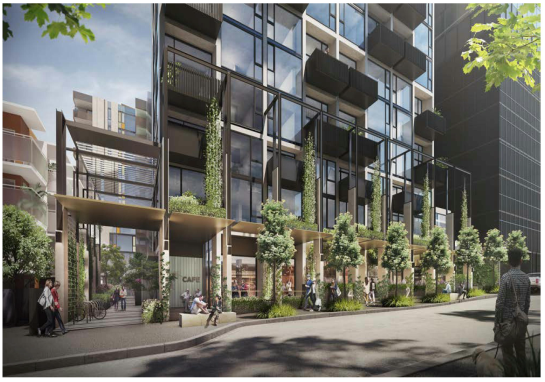
Figure 3 – Artist Impression
– vertical gardens – Bruce Street frontage
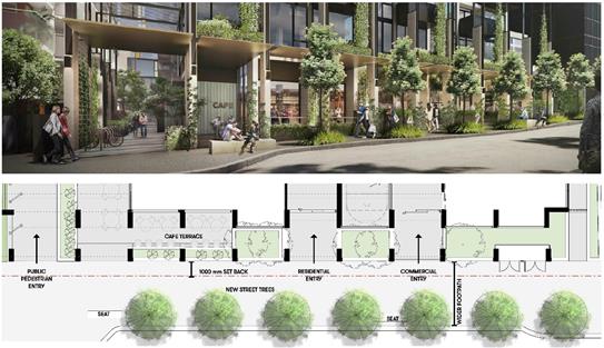
Figure 4 – Artist Impression
– Pedestrian level planting – Bruce Street frontage
Clause 58, Apartment
developments and Apartment Design Guidelines for Victoria
Planning officers have assessed the
proposal against the requirements of Clause 58, Apartment Developments and the
Apartment Design Guidelines for Victoria. The proposed apartments are
considered to deliver high quality, functional and efficient accommodation and
associated open space. A summary of key assessments includes:
· Appropriate
daylight access has been provided to key areas of the buildings and in
particular all habitable spaces of the proposed dwellings.
· The
proposed setbacks of the buildings has enabled dwellings to have, where
possible, a dual aspect outlook.
· Most
dwellings optimise a northern, eastern and western outlook and single aspect
south facing dwellings are limited to two dwellings on each level for the
western building and just one dwelling per level on the eastern building.
· A
minimum eight square metres private open space is provided for each dwelling.
· All
corridors have natural ventilation and daylight access.
· Communal
open space is provided in locations that will achieve good daylight access.
· The
outlook from the proposed south facing apartments, in the western building at
levels 2-18, that have a single aspect orientation to the ATO building is
considered acceptable. This is due to the varying setback distance of
between 6.9 metres to 9.1 metres from the ATO building, which will enable
adequate daylight access and ventilation to these dwellings.
It is considered that the proposal
complies with the requirement of Clause 58 Apartment Developments. Similarly, officers’
assessed the proposal against the requirements in the Apartment Design
Guidelines for Victoria and concluded that the proposed development largely
complies subject to standard conditions relating to wind criterion for
“sitting” and “standing” comfort to be applied to all
private balconies, which is discussed below.
Clause 55, Two or more
Dwellings on a lot and Residential Buildings
Pursuant to Clause 32.04-10
(Buildings on lots that abut another residential zone) of the Mixed Use Zone, any
buildings and works constructed on a lot that abuts land which is in
Residential Growth Zone (RGZ) must meet the requirements of Clauses
55.03-5, 55.04-1, 55.04-2, 55.04-3, 55.04-5 and 55.04-6 along that boundary.
The site abuts RGZ land to the north
and east. Therefore an assessment of the proposal against the requirements of
Clause 55 is required and can be summarised as follows:
· Clause
55.04-1 (side and rear setbacks – Standard B17) – A variation is
necessary to the side setbacks along the northern and southern
boundaries. It is noted that lower scale buildings currently exist along
both of these interface with the site. However, these sites have been
identified for higher density development as they are situated/identified
within Precinct F – Major Development Precinct under Clause 22.07 of the
Whitehorse Planning Scheme.
· Clause
55.04-2 (walls on boundaries – Standard B18) – Not applicable as
there are no walls proposed along the northern and eastern boundaries.
· Clause
55.04-3 (daylight to existing windows – Standard B19) – The
proposal complies with this standard as the proposal will achieve a minimum
setback of at least 3.5 metres from the abutting property to the east (5 Elland
Avenue), ensuring that a minimum light court area of 3 square metres is
achieved for the existing west-facing windows of the adjoining property at 5
Elland Avenue.
· Clause
55.04-5 (overshadowing of open spaces – Standard B21) – A variation
is required. Shadow plans provided by the applicant shows an increase in
shadowing to the abutting property to the east (5 Elland Avenue), after the 1
pm. While it is acknowledged that there will be direct overshadowing
impacts on the existing private open space area, located at 5 Elland
Avenue. The proposed building design and setbacks still ensures a minimum
of 4 hours of sunlight access between the hours of 9 am to 1 pm, this is
considered reasonable given the built form context of the site.
The only alternative to achieve full
compliance is to reduce the height of the eastern building substantially from
35 metres to approximately 7 metres (double storey height). However, this
would result in a significant under-utilisation of a key site and would be
unreasonable from a strategic policy perspective. This is in essence, the
challenge presented by an abuttal of a MUZ to the RGZ in the context of a MAC.
· Clause
55.04-6 (overlooking – Standard B22) – The owner/occupier of the
adjoining property at 5 Elland Avenue (east) has raised concerns relating to
the issues of potential overlooking from the proposed east facing
balconies. An assessment of the proposed plans and elevations suggest
that, while there are some screening measures intended to limit views into the
rear secluded private open space area at 5 Elland Avenue, this is considered
insufficient. This can be addressed by way of permit conditions, should
one be issued, requiring compliance with Standard B22.
Environmentally Sustainable
Development (ESD)
Redevelopment of the site, located
in an existing mixed use area, makes more efficient use of existing
infrastructure and services, and the proximity of the subject site to numerous
public transport modes which reduce employees and visitors from relying on
private vehicles. Policy at clauses 15.02, Sustainable Development,
15.02-1S, Energy and Resource Efficiency, 21.05, Environment and 22.10,
Environmentally Sustainable Development of the Scheme, encourage ecologically
sustainable development, with regard to water and energy efficiency, building
construction and ongoing management.
Council’s ESD Advisor has identified
a number of omissions to be addressed including energy efficiency ratings, air
conditioning details, ventilation, water tank sizes, recycled water for
landscaping and cladding finishes. These matters are all considered reasonable
and conditions are recommended in an amended SMP and annotated on the plans.
Off-site amenity impacts
Policy Guidance
The policy framework for amenity
considerations is contained within Clause 65 (Decision Guidelines).
Clause 22.05 (Non-residential Development in Residential Area) of the Scheme is
not strictly applicable but provides some useful guidance.
The objectives at Clause 22.05-2 aims
to limit the impact of new development on the amenity of surrounding land,
particularly residential land. The following objectives are applicable:
· To
make provision for services and facilities demanded by local communities in a
way that does not detract from the amenity of the area.
· To
ensure that the design, scale and appearance of non-residential premises
reflects the residential character and streetscape of the area.
· To
ensure that the location of the use is appropriate to the role and function of
the road network and that adequate provision is made for onsite car parking.
This application must consider both
the off-site amenity impacts for residential land as well as any potential
impacts to existing commercial uses in the context of the area. Clause
22.05 acknowledges that there is a need for non-residential uses in residential
areas to serve the needs of the local community, particularly well located
sites with redevelopment opportunities such as the current application
site. With this in mind, residences which abut a non-residential zone
should not have unrealistic expectations of the level of amenity which can be
achieved. The appropriateness of amenity impacts including setbacks, walls on
boundaries, shadowing and overlooking need to be considered within their
strategic context, with the site being located within a Mixed Use Zone. In
addition, surrounding character shows a high level of building site coverage
and boundary-to-boundary for those developments currently surrounding the site,
in particular along Whitehorse Road frontage.
As previously outlined, the subject
site does directly abut residential zoned land to the north, east, west and
commercial land to the south. To address potential amenity considerations
to the north and east, the proposal has incorporated the following setbacks:
· North
– ground level – 3.5 metres
· North
– first floor (communal terrace) – varying between 4.9 metres and
6.9 metres
· North
– above first floor – varying between 4.9 metres and 10.8 metres
· East
– ground floor – approximately 2.3 metres
· East
– above ground floor – varying between 3.5 metres and 4.5 metres
Whilst the existing building to the
north includes terraces/balconies along the shared boundary which directly have
the potential to overlook into the development site, the proposal is setback
beyond 9 metres above the ground level along this interface, with all secluded
private open space area (balconies) located beyond 9 metres. Furthermore, the
proposal includes a terrace at first floor which directly abuts these areas.
This terrace area for the most part will have a 1.1m high planter which
combined with the terrace widths provides a visual buffer both in terms of
height and width. Occupants of this communal terrace are not able to stand
against the podium edge and are setback at least 6.9m from the shared boundary,
so there are no direct overlooking sightlines.
The proposal has also considered
equitable development to its east through the incorporation of varying setbacks
of at least 3.5 metres in in part up to 4.5 metres for all levels above the
ground floor. Any new development to the east would be expected to provide a
recessed setback which would result in acceptable building separation.
Noise and light spill
The proposal is unlikely to result
in unacceptable noise emissions to the nearby residential properties given the
majority of the building would be used for residential and offices. Due to the
nature of the residential and office use, there will be minimal noise generated
by the pedestrian activity. The pedestrian movement will be concentrated
towards Bruce Street frontage and the pedestrian path to the north.
Therefore, it is not considered to be detrimental to the amenity of the
adjacent properties. The use also ensures that deliveries to the site can be
managed via Hilton Lane, which is an existing collection and delivery point for
the commercial building fronting Whitehorse Road. Regardless, a condition
of any approval is recommended, requiring that the noise and emissions from
plant equipment must comply at all times with the State Environment Protection
Policy – Control of Noise from Commerce, Industry and Trade (SEPP N1) and
the Health and Wellbeing Act 2008.
The proposed food and drink premise
does not require a planning permit and no further control can be imposed in
this application.
Wind
The proposal has provided a Wind
Impact Assessment (pedestrian level winds & wind tunnels). There are
three relevant criteria, described as follows:
1) Sitting
comfort,
2) Standing
comfort, and
3) Walking
comfort
It is noted there are no industry
wide standards and no measurable specification in the planning scheme.
Direction is provided by anecdotal evidence of CBD wind assessments. Planning
officers have required assurances that at least these standards must be met.
The Wind Impact Assessment has
concluded that the proposed design of the building would fulfil the recommended
criterion for safety at all test locations (ground, podium terrace, and rooftop
terrace). The proposal would meet requirements for “walking” along
all footpath locations and “standing” at the main entrances. “Standing”
and in part “sitting” criteria would be met at the Level 1 communal
terrace area and rooftop communal terraces. Similarly, “standing”
and “sitting” criteria would be met for the private balcony spaces.
The report recommends educating
occupants about wind conditions at high-level terraces/balconies during
high-wind events and tying down lightweight furniture is highly recommended.
Council’s ESD Advisor has
also recommended conditions in relation to the comfort level for the relevant
public and private outdoor spaces. These requirements are included in
conditions for any approval granted.
Car parking, traffic, access
and bicycle provision
Car parking in the Box Hill
Activity Centre is managed by the Schedule 1 to the Parking Overlay, including the
following objectives:
· Manage
car parking demand and supply to satisfy user needs (with a focus on
maintaining/increasing the viability of Box Hill).
· Locate
and manage car parking so as to minimise traffic generated by the search for a
parking space.
· Encourage
the use of active and sustainable travel modes rather than increased private
vehicle travel.
· Improve
general amenity for pedestrians within Box Hill to increase the willingness for
visitors and staff to walk to and within the Centre to their destination.
Council’s Transport team have
reviewed the proposed car parking provision and in summary have provided the
following comments:
Car Parking Assessment
a) The
land is included in the Parking Overlay (Schedule 1). This overlay varies the
car parking rates set out in Clause 52.06. Applying the varied rate under
the Parking Overlay, the proposal generates a requirement for 202 car parking
spaces. The proposed development provides for 210 car parking spaces
which are distributed as follows:
i. 170
car parking spaces for the residential use, exceeding the required 148 car
parking space.
ii. 24
car parking spaces for visitors parking
iii. 13
car parking spaces for the office use
iv. 3 car parking
spaces for the food and drink premises (café) use
|
|
Qty
|
Parking rate
|
Statutory Parking Spaces Required
|
Parking spaces Provided
|
|
One Bed Dwellings (and lofts)
|
53
|
0.5 spaces per dwelling
|
26.5
|
|
|
Two Bed Dwellings
|
95
|
0.75 spaces per dwelling
|
71.25
|
|
Two Bed Dwellings with loft (treated as
Three Bed Dwellings
|
14
|
1.0 space per dwelling
|
14
|
|
One Bed affordable Dwellings
|
18
|
0.5 spaces per dwelling
|
9
|
|
Two Bed affordable Dwellings (including
Dual Access dwellings)
|
55
|
0.75 spaces per dwelling
|
41.25
|
|
Visitor Spaces
|
235 dwellings
|
0.2 spaces per dwelling for first 5 dwellings then 0.1 spaces per
dwelling for remainder
|
24
|
|
Commercial Office
|
650.7 sqm
|
2.0 spaces per 100sqm
|
13*
|
|
Commercial Retail
|
84.2 sqm
|
3.5 spaces per 100sqm
|
3*
|
|
Overall Parking
|
|
|
202
statutory car spaces required for the
development
|
210 spaces over 4 basement levels inc. 4 Ground Level visitor spaces
|
|
Ø * When
calculating the number of parking spaces and the result is not a whole
number, the required number of parking spaces is to be rounded down to the
nearest whole number in accordance with the requirements set out in the
Whitehorse Planning Scheme.
|
Table 1 – Statutory Car
Parking Assessment
b) 205
car parking spaces are accessed via Elland Avenue with 5 car spaces accessed
via Hiltons Lane for service access, waste collection and visitor access.
c) There
is no vehicle access via Bruce Street. This traffic arrangement is
considered acceptable to limit traffic access onto Bruce Street.
d) There
is likely to be an increase in traffic along Elland Avenue which is a dead
end. While this is only accessed via Station Street, the development
traffic is expected to be satisfactorily managed in the area. Hilton Lane
may also be used on a very small scale.
e) The
car parking layout is generally considered to be acceptable on all four
basement levels and ground level parking.
Bicycle parking assessment
There is a bicycle parking
requirement to provide 70 bicycle spaces. The proposal has provided 84
bicycle parking spaces. 24 visitor spaces have been provided
abutting to the north of the café area and west of the under-croft area
of eastern building (Elland Avenue frontage). The remaining 60
spaces are located within two sections at ground level, internal to the
building.
No
bicycle spaces are required for the office or food and drink premises.
Overall the proposal achieves high
compliance with respect to the car parking and bicycle parking requirements.
Furthermore, it is not anticipated that the traffic generation from the
development will result in negative impacts to the existing street networks.
Drainage and assets
The site is located within the
flood investigation area, whereby the land has the potential to be affected by
water overflow from stormwater run-off. The application was initially
referred to Council’s Asset Engineering Team, who have raised concerns
relating to the development potentially having an impact on the overland
stormwater flow path. It is understood that this stormwater flow path
would typically run across the surface of the car parking area and drains off
into the existing pits along Bruce Street frontage. Hence, the proposed
building layout would impact on this overland flow path and will need to be
either redirected to Bruce Street at the front of the property or to Irving
Avenue.
The applicant has since submitted
information, including a full Hydrological and Hydraulic modelling report
suggesting a new direct flow path and additional flood level survey information
of the surrounding area. Council’s Asset Engineering Team have
reviewed the additional information and recommended several conditions to form
part of an approved permit.
Objectors Concerns not
Previously Addressed
a) Oversupply and Density: Density and
saturation ratios are not part of the planning assessment. Furthermore, both
the State and local planning policies encourage urban consolidation in
established residential areas and in particular Major and Metropolitan Activity
Centres.
b) Blocking
of daylight and sunlight (solar panel): The Decision Guidelines at Clause
32.04, Mixed Use Zone, requires an impact assessment of overshadowing on
existing rooftop solar energy facilities on dwellings abutting a development
site. It is acknowledged that there will be direct overshadowing impacts
on the existing solar panels, located on the adjoining eastern property (5
Elland Avenue), particularly after 1 pm. These panels are currently located on
the lower portion of the west facing roof. Noting this, and
together with the fragmented design of the existing roof form, there is no
potential area to which these panels could be relocated.
The only alternative to mitigate the
impact of overshadowing to these panels is to reduce the height of the eastern
building substantially from 35 metres to approximately 7 metres (double storey
height). However, this would result in a major under-utilisation of a key
development site and would be unreasonable from a strategic policy
perspective. In this instance, the location, scale and nature of the
proposed development is consistent with the expectation of the Box Hill
Structure Plan and is deemed to adequately satisfy many policy objectives
outlined at both the state and local planning policies.
c) Reflections:
All materials and cladding proposed are non-reflective in nature. The
exception is the glazed surfaces of all window treatment which are
predominantly recessed from the main building wall.
d) Pollution:
It appears that this objection is in relation to noise, air, water and
light. All of which have been addressed earlier in this report. The
exception is air pollution, generated by vehicles from the development which is
not a planning consideration. It is also acknowledged that the proposed
development has achieved adequate compliance with the vehicular parking and
access provisions of Clause 52.06, Car Parking.
e) Loss
of quality of life and health: The use and development of the
proposed dwellings will be managed to ensure no unreasonable amenity impacts to
surrounding lots, with various planning, building and civil enforcement
mechanisms in place to regulate this.
f) Increase
traffic: The proposal has been assessed by Council’s Transport
Engineers who are satisfied that the additional traffic generation can be
absorbed by the surrounding street network.
g) Parking
congestion: Council’s Transport Engineers are satisfied that the
on-site parking provision is sufficient to support the car parking demand, in
accordance with the Planning Scheme requirements.
h) Hazard to bike riders: The proposal does not
seek to alter the existing road layout and will achieve a compliant street
network layout that will support bicycle traffic.
i) Loss
of Council’s public car park: It is acknowledged that the current
land use would cease should this development be approved. However, within
the location, the scale and nature of the proposed use and development is
consistent with the expectation of the Box Hill Structure Plan.
j) Loss of through road access: The
proposed alterations to the street network have been assessed by
Council’s Transport Engineers and are considered an appropriate outcome
for the area. Furthermore, the Box Hill Transit City Activity Centre
Structure Plan does not identify the site a through road access.
k) Loss of vegetation and habitats: The
redevelopment of this site is supported by State and Local Policies, and
Council’s strategic direction provides for the retention of trees and
habitat improvements elsewhere in the municipality to balance the intensive
development of Major Activity Centres.
l) Reduction in public open space: Council
policy as set out in the Box Hill Structure Plan and Whitehorse
Open Space Strategy do not identify the subject site as public open space,
and the strategic direction for this area allows for the provision of parks and
public open spaces convenient to this precinct.
m) Noise
and construction noise impacts: The residential use of the dwellings does
not require a planning permit. Residential noise associated with a dwelling is
considered normal in an urban setting. Any future issues of amenity, if they
arise, should be pursued as a civil matter. It is acknowledged off site impacts
are inevitable when any construction occurs. The developer will be
required to meet relevant Building and EPA regulations, a Construction
Management Plan (CMP) will be required as a condition of any approved granted.
n) Affordable
housing attracts “unsuitable” tenants : The consideration of
this planning application is confined only to the construction of the
dwellings, the residential use and occupancy arrangements of the dwellings are
beyond the scope of this planning assessment.
o) Emergency
Service Access: Emergency service requirements such as fire regulations are
considered through the Building Permit process.
p) Precedent
– Each application is assessed in relation to the relevant planning
controls, its site context, the prevailing neighbourhood character and merits
of the development design.
q) Property Devaluation - The
Victorian Civil and Administrative Tribunal and its predecessors have generally
found subjective claims that a proposal will reduce property values are
difficult, if not impossible to gauge and of no assistance to the determination
of a planning permit application. It is considered the impacts of a proposal
are best assessed through an assessment of the amenity implications rather than
any impacts upon property values.
CONCLUSION
The proposed buildings and works to
construct two towers (10 storey and 19 storey) to provide 235 dwellings and
part use of the land for the purpose of office is an acceptable response that
satisfies the relevant provisions contained within the Whitehorse Planning
Scheme, including the State and local planning policies, the purpose and
decision guidelines of the Mixed Use Zone, where relevant the Residential
Growth Zone and Clause 58 – Apartment Developments.
Notably, the proposal achieves the
State Government’s urban consolidation objectives, Council’s
preference to direct higher density mixed use development in commercial
precincts/MAC.
In addition to making a
contribution to meeting Whitehorse’s future housing needs, the proposal
provides for a mixture of uses consistent with the Mixed Use Zone and local
policies applicable for the Box Hill MAC. The building has been designed
to respond to the site’s varying interfaces, to provide a high level of
amenity for future residents and to activate the street frontages. The
proposal provides community benefits in the form of an additional 73 dwellings
associated with the affordable housing. Improved public realm benefit is
also achieved due to the proposal maintaining pedestrian-links which is open to
the public and provides new and improved existing pedestrian access to both
east-west and north-south.
A total of thirteen (13) objections
were received as a result of public notice and all of the issues raised have
been considered as part of this assessment.
Attachment
1 Architectural
Plans ⇨ 
2 Advertising -
Landscape Plans ⇨ 
Ordinary Council Minutes 25
February 2019
9.1.2 26
Salisbury Avenue, Blackburn (LOT 48 LP 9968): Construction of two (2), part
double storey, part triple storey, dwellings and associated vegetation removal
FILE NUMBER: WH/2017/1037
ATTACHMENT
SUMMARY
This application was advertised,
and a total of 31 objections (from 18 properties) were received. The objections
raised issues of neighbourhood character, vegetation removal, traffic and car
parking, amenity impacts and damage to council’s infrastructure. A
Consultation Forum was held on 26th June 2018 chaired by Councillor
Denise Massoud, at which the issues were explored, however no resolution was
reached between the parties.
Subsequent
amended plans introduced a number of positive changes to the proposal, namely a
complete redesign in dwelling arrangement from tandem to a side-by-side
formation. Other key changes include a more centralised and mirrored built form
with separate driveways, a split-level design, increased boundary setbacks and
reduced excavation and altered tree impacts. There remain some outstanding
matters with regard to tree planting, landscaping and design outcomes which can
be addressed through permit conditions.
This report assesses the
application against the relevant provisions of the Whitehorse Planning Scheme,
and objector concerns. It is recommended that the application be
supported, subject to conditions.
|
Council
Resolution
Moved by Cr Massoud,
Seconded by Cr Munroe
That Council:
A Being
the Responsible Authority, having caused Application WH/2017/1037 for 26
Salisbury Avenue, BLACKBURN (LOT 48 LP 9968) to be advertised and having
received and noted the objections is of the opinion that the granting of a
Planning Permit comprising building and works for the Construction of two
(2), part double storey, part triple storey, dwellings and associated
vegetation removal is acceptable and should not unreasonably impact the
amenity of adjacent properties.
B Issue
a Notice of Decision to Grant a Permit under the Whitehorse Planning Scheme
to the land described as 26 Salisbury Avenue, BLACKBURN (LOT 48 LP 9968)
comprising building and works for the Construction of two (2), part double
storey, part triple storey, dwellings and associated vegetation removal,
subject to the following conditions:
1. Before
the development starts, or any trees or vegetation is removed, amended plans
must be submitted electronically to and approved by the Responsible
Authority. The plans must be drawn to 1:100 scale, with dimensions, and be
generally in accordance with the plans submitted with the application but
modified to show:
a) The
locations of Tree Protection Zones described in condition 5, with all
nominated trees clearly identified and numbered on both site and landscape
plans, and the requirements of conditions 5 and 6 to be annotated on the
development and landscape plans.
b) All
obstructions within the sight line triangle (including letter boxes, meter
boxes and side boundary fencing) to be no higher than 0.9 metre in height, or
be relocated clear of the sight line triangle in accordance with Clause
52.06-8.
c) Deletion
of reference to front fence and a 0.9 metre high retaining wall dividing the
front yards of both dwellings detailed.
d) Provision
of permeable paving to driveways to promote the growth of new trees within
the front setback.
e) Water
tanks to be shown on drawings and located outside of the TPZ of protected
trees.
f) A
landscape plan in accordance with condition 3, including the following:
i. The
planting of one upper canopy tree with a minimum mature height of 12 metres
within each of the front setback areas of Dwelling 1 and Dwelling 2.
ii. The
planting of one upper canopy tree with a minimum mature height of 12 metres
within each of the rear private open space areas of Dwelling 1 and Dwelling
2.
iii. Screening
vegetation with a minimum mature height of 3 metres to be planted along the
full extent of the north and south boundaries.
iv. All
trees are to have a minimum height of 1.5 metres at the time of planting, and
should be planted a minimum 3 metres away from dwellings and a minimum 1
metre from property boundaries.
v. The
removal of trees 10, 11, 12, 13, 14 and 17 clearly detailed.
g) All
upper level windows on the north elevation to be screened to a height of 1700mm
above floor level.
h) Notation
on site plans indicating that all obscured glazing be manufactured obscured
glass. Obscure film being applied to clear glazing will not be accepted.
i) The
pedestrian doors to garages to open outwards so as to not obstruct the
dedicated internal car parking area.
All of the above must be
to the satisfaction of the Responsible Authority. Once approved these plans
become the endorsed plans of this permit.
2. The
layout of the site and the size, design and location of the buildings and
works permitted must always accord with the endorsed plan and must not be
altered or modified without the further written consent of the Responsible
Authority.
3. No
building or works must be commenced (and no trees or vegetation shall be removed)
until a landscape plan prepared by a suitably qualified and experienced
person or firm has been submitted to and endorsed by the Responsible
Authority. This plan when endorsed shall form part of this
permit. This plan shall show:
a) A
survey of all existing vegetation, abutting street trees, natural features
and vegetation.
b) Buildings,
outbuildings and trees in neighbouring lots that would affect the landscape
design.
c) Planting
within and around the perimeter of the site comprising trees and shrubs
capable of:
i. Providing
a complete garden scheme,
ii. Softening
the building bulk,
iii. Providing
some upper canopy for landscape perspective,
iv. Minimising
the potential of any overlooking between habitable rooms of adjacent
dwellings.
d) A
schedule of the botanical name of all trees and shrubs proposed to be
retained and those to be removed incorporating any relevant requirements of
condition No. 1.
e) The
proposed design features such as paths, paving, lawn and mulch.
f) A
planting schedule of all proposed vegetation (trees, shrubs and ground
covers) which includes, botanical names, common names, pot size, mature size
and total quantities of each plant.
Landscaping in accordance
with this approved plan and schedule shall be completed before the addition
to the building is occupied.
Once approved these
plans become the endorsed plans of this permit.
4. The
garden areas shown on the endorsed plan must only be used as gardens and must
be maintained in a proper, tidy and healthy condition to the satisfaction of
the Responsible Authority. Should any tree or shrub be removed or
destroyed it may be required to be replaced by a tree or shrub of similar
size and variety.
5. Prior
to the commencement of any building and or demolition works on the land, a Tree
Protection Zone (TPZ) must be established and maintained on the subject land
during and until completion of all buildings and works including landscaping,
around the following trees in accordance with the distances and measures
specified below, to the satisfaction of the Responsible Authority:
a) Tree
Protection Zone distances:
i. Tree
5 – Callistemon sp (Bottlebrush) –2.0 metres radius from the
centre of the tree base.
ii. Tree
6 – Callistemon sp (Bottlebrush) –2.0 metres radius from the
centre of the tree base.
iii. Tree
7 – Acacia dealbata (Silver Wattle) –2.0 metres radius from the
centre of the tree base.
iv. Tree
8 – Pittosporum undulatum (Sweet Pittosporum) –2.0 metres radius
from the centre of the tree base.
v. Tree
9 – Pittosporum eugenioides (Lemonwood) –2.4 metres radius from
the centre of the tree base.
vi. Tree
15 – Syzygium smithii (Lilly Pilly) –5.2 metres radius from the
centre of the tree base.
vii. Tree
16 – Casuarina (She-oak) –3.8 metres radius from the centre of
the tree base.
viii. Tree
18 – Acacia dealbata (Silver Wattle) –3.0 metres radius from the
centre of the tree base.
ix. Tree
20 – Eriobotrya japonica (Loquat) –2.0 metres radius from the
centre of the tree base.
x. Tree
21 – Melaleuca linariifolia (Snow in summer) –2.0 metres radius
from the centre of the tree base.
xi. Tree
24 – Eucalyptus nicholii (Narrow-leaf Black Peppermint) –12.0
metres radius from the centre of the tree base.
b) Tree
Protection Zone measures are to be established in accordance to Australian
Standard 4970-2009 and including the following:
i. Erection
of solid chain mesh or similar type fencing at a minimum height of 1.8 metres
in height held in place with concrete feet.
ii. Signage
placed around the outer edge of perimeter the fencing identifying the area as
a TPZ. The signage should be visible from within the development, with the
lettering complying with AS 1319.
iii. Mulch
across the surface of the TPZ to a depth of 100mm and undertake supplementary
watering in summer months as required.
iv. No
excavation, constructions works or activities, grade changes, surface
treatments or storage of materials of any kind are permitted within the TPZ
unless otherwise approved within this permit or further approved in writing
by the Responsible Authority.
v. All
supports and bracing should be outside the TPZ and any excavation for
supports or bracing should avoid damaging roots where possible.
vi. All
sub surface utilities and utility connection points, inspection pits and
associated infrastructure trenching and installation are to be designed so
that they are located outside the TPZs of retained trees, to the satisfaction
of the Responsible Authority. Utility conduits can be located beneath
TPZs but must be installed using trenchless excavation (eg: boring) and
installed to a minimum depth of 0.6 metres below natural grade.
vii. Where
construction is approved within the TPZ, fencing and mulching should be
placed at the outer point of the construction area.
viii. Where
there are approved works within the TPZ, it may only be reduced to the
required amount by an authorised person only during approved construction
within the TPZ, and must be restored in accordance with the above
requirements at all other times.
6. During
the construction of any buildings or works, the following tree protection
requirements must be carried out to the satisfaction of the Responsible
Authority:
a) A
project arborist must be appointed by the applicant or builder. Any
Qualifications must read ‘Arboriculture’ for
example ‘Diploma in Horticulture (Arboriculture)’. The project
arborist must have a minimum Diploma qualification in arboriculture to be
appointed as the project arborist.
b) For
Trees 5, 6, 7, 8, 9, 15, 16, 18, 20, 21 and 24, no roots
greater than 40mm in diameter are to be cut or damaged during any part of the
construction process.
c) All
buildings and works for the demolition of the site and
construction of the development (as shown on the endorsed plans) must not
alter the existing ground level or topography of the land within greater than
10% of the TPZs of Trees 5, 6, 7, 8, 9, 15, 16, 18, 20, 21 and
24.
d) The
project arborist must supervise or undertake all approved works
within the TPZs of Trees 5, 6, 7, 8, 9, 15, 16, 18, 20, 21 and
24. Any root severance within the TPZ must be undertaken to their
satisfaction and using a clean sharp and sterilised pruning saw. There must
be no root pruning within the SRZ of this tree. There must be no works
undertaken within the TPZ other than those endorsed by the Responsible
Authority (RA).
e) The
project arborist and builder must ensure that TPZ Fencing Conditions are
being adhered to throughout the entire building process, including site
demolition, levelling and landscape works.
7. All
underground service pipes including storm water and sewerage must be diverted
around any Tree Protection Zones of trees to be retained, or bored underneath
with a minimum cover of 800mm to top of conduit from natural surface level.
If the trees have not been assessed the TPZ is calculated by 12x the trunk diameter
measured at 1.4m above ground level.
8. The
development must be provided with external lighting capable of illuminating
access to each garage and car parking space. Lighting must be located,
directed and shielded and of limited intensity that no nuisance or loss of
amenity is caused to any person within and beyond the site.
9. All
stormwater drains and on-site detention systems are to be connected to the
legal point of discharge to the satisfaction of the Responsible Authority
prior to the occupation of the building/s. The requirement for on- site
detention will be noted on your stormwater point of discharge report, or it
might be required as part of the civil plans approval.
10. Detailed
stormwater drainage and/or civil design for the proposed development are to
be prepared by a suitably qualified civil engineer and submitted to the
Responsible Authority for approval prior to occupation of the
development. Plans and calculations are to be submitted with the
application with all levels to Australian Height Datum (AHD). All
documentation is to be signed by the qualified civil engineer.
11. Stormwater
that could adversely affect any adjacent land must not be discharged from the
subject site onto the surface of the adjacent land.
12. Prior
to works commencing the Applicant/Owner is to submit design plans for all
proposed engineering works external to the site. The plans are to be
submitted as separate engineering drawings for assessment by the Responsible
Authority.
13. The
Applicant/Owner is responsible to pay for all costs associated with
reinstatement and/or alterations to Council or other Public Authority assets
as a result of the development. The Applicant/Owner is responsible to
obtain all relevant permits and consents from Council at least 7 days prior
to the commencement of any works on the land and is to obtain prior specific
written approval for any works involving the alteration of Council or other
Public Authority assets. Adequate protection is to be provided to
Council’s infrastructure prior to works commencing and during the
construction process.
14. The
qualified civil engineer when undertaking civil design must ensure that the
landscape plan/s and drainage plan/s are compatible. The stormwater
drainage and on site detention system must be located outside the tree
protection zone (TPZ) of any trees to be retained.
15. All
treatments to prevent overlooking must not include ‘Translucent
film’ on windows and must be in accordance with Standard B22 of Clause
55.
16. The
existing street tree must not be removed or damaged except with the written
consent of the Responsible Authority.
17. This
permit will expire if one of the following circumstances applies:
a) The
development is not commenced within two (2) years from the date of issue of
this permit;
b) The
development is not completed within four (4) years from the date of this
permit.
The Responsible
Authority may extend the periods referred to if a request is made in writing
pursuant to the provisions of Section 69 of the Planning and Environment Act
1987.
Permit Notes:
A. The
design and construction of the stormwater drainage system up to the point of
discharge from an allotment is to be approved by the appointed Building
Surveyor. That includes the design and construction of any required
stormwater on-site detention system. The Applicant/Owner is to submit
certification of the design of any required on-site detention system from a
registered consulting engineer (who is listed on the Engineers Australia
National Professional Engineer Register or approved equivalent) to Council as
part of the civil plans approval process.
B. The
requirement for on- site detention will be noted on your stormwater point of
discharge report, or it might be required as part of the civil plans
approval.
C. All
proposed changes to the vehicle crossing are to be constructed in accordance
with the submitted details, Whitehorse Council’s – Vehicle
Crossing General Specifications and standard drawings
D. The
Applicant/Owner is to accurately survey and identify on the design plans all
assets in public land that may be impacted by the proposed development. The
assets may include all public authority services (i.e. gas, water, sewer,
electricity, telephone, traffic signals etc.) and the location of street
trees or vegetation. If any changes are proposed to these assets then the
evidence of the approval is to be submitted to Council and all works are to
be funded by the Applicant/Owner. This includes any modifications to
the road reserve, including footpath, nature-strip and kerb and channel.
E. The
Applicant/Owner must obtain a certificate of hydraulic compliance from a
suitably qualified civil engineer to confirm that the on-site detention works
have been constructed in accordance with the approved plans, prior to
Statement of Compliance is issued.
F. There
is to be no change to the levels of the public land, including the road
reserve or other Council property as a result of the development, without the
prior approval of Council. All requirements for access for all-abilities
(Disability Discrimination Access) are to be resolved within the site and not
in public land.
C. Has made this decision having particular
regard to the requirements of Sections 58, 59, 60 and 61 of the Planning and Environment
Act 1987.
Carried
|
|
A Division was called.
Division
|
For
Cr
Barker
Cr
Bennett
Cr
Davenport
Cr
Ellis
Cr Liu
Cr
Massoud
Cr
Munroe
|
Against
Cr
Carr
Cr
Cutts
Cr
Stennett
|
On
the results of the Division the motion was declared carried
|
MELWAYS REFERENCE 47 H10
|
Applicant: Architeria
Architects
Zoning: General
Residential Zone, Schedule 2 (GRZ2)
Overlays: Significant
Landscape Overlay, Schedule 9 (SLO9)
Relevant Clauses:
Clause 11 Settlement
Clause 15 Built
Environment and Heritage
Clause 21.05 Environment
Clause 21.06 Housing
Clause 22.03 Residential
Development
Clause 22.04 Tree
Conservation
Clause 32.01 General
Residential Zone 2
Clause 52.06 Car
Parking
Clause 55 Two
or More Dwellings on a Lot or Residential Buildings
Clause 65 Decision
Guidelines
Ward: Central
|
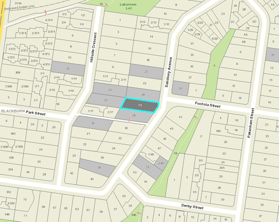
|
|
|
Subject site
|
|
18 Objector Properties
(6 outside of map)
|
é
North
|
BACKGROUND
History
There are no previous planning applications for the subject
site.
The Site and Surrounds
The site is a single parcel of land known as Lot 48 LP9968,
and contains no restrictions or agreements on Title. The site is located on the
west side of Salisbury Avenue in Blackburn, 300 metres south of Laburnum Train
Station. The site has a frontage of 16.29 metres to Salisbury Avenue, and
a depth of 45.5 metres in an irregular shaped block, and a total site area of
717m2. The site has a slope of 6.0 metres from west to east along
the long boundary of the site.
The site contains a single level weatherboard house, with a
carport located under the front of the building. There are a number of small
trees with the dwelling set among an ornamental garden setting.
The land is well serviced by social infrastructure and
services in the surrounding area. Within 500 metres to the west and south are
Box Hill High School and Laburnum Primary School respectively. Approximately
300 metres north-east of the site on Salisbury Avenue is a local strip shopping
centre and Laburnum train station. The Blackburn Creeklands public reserve is
located 300 metres south of the site, while major bus routes operate along
Middleborough Road connecting to Box Hill, Doncaster and the eastern freeway.
The surrounding properties are residential containing a mix of
single and double storey brick and timber dwellings set on lot sizes varying
between 250m² to 850m² in area within Salisbury Avenue, and between
320m² and 800m² north of the site being close to Laburnum Train
Station. There are a number of multi-unit developments in the area. A mixture
of native and exotic canopy trees appear mainly within the streetscapes and
along the perimeter of residential properties in the area.
Planning Controls
In accordance with Clause 32.08-6 (General Residential Zone 2)
of the Whitehorse Planning Scheme, a Planning Permit is required for the
construction of two or more dwellings on a lot.
In accordance with Clause 42.03 (Significant Landscape
Overlay, Schedule 9) a permit is required to remove, destroy or lop a tree and
to construct a building or construct or carry out works.
PROPOSAL
The proposal comprises building and works for the Construction
of two (2), part double storey, part triple storey, dwellings and associated
vegetation removal. Given their side by side arrangement, both dwellings will
face the street. The southern dwelling will have access from the existing
southern crossover, while dwelling 2 will require a new northern crossover to
Salisbury Avenue.
The dwellings will have a single tandem garage arrangement
with a long driveway that can accommodate between one and two additional
visitor car spaces per dwelling. The garages are located at street level
and are excavated into the site.
The internal layout at ground and first floor levels are
similar for both dwellings. A front entry porch is located at ground level with
stairs leading up to the first floor. This level includes a master bedroom
facing the street and internal split level leading up to an open plan kitchen /
living area to the rear. The secluded private open space (SPOS) is provided to
the rear of each dwelling at natural ground level with good northern solar
access.
The second floor of Dwelling 1
contains three bedrooms, shared bathroom for bedrooms 3 and 4, with an ensuite
and walk in robe (WIR) provided for bedroom 2. Dwelling 2 will contain three
bedrooms with ensuites.
The proposed dwellings will have a
maximum overall height ranging from 7.7 metres to 8.1 metres due to the fall of
the land, incorporating roof eaves.
The materials and colour palette
for both dwellings include a mix of face brickwork, timber weatherboard and
render for external walls, along with grey concrete tiled roofing.
The proposal includes the removal of five trees protected
under SLO9 (trees 10, 11, 12, 13 and 17) as detailed below. The proposal also
seeks the removal of three (3) trees (trees 2, 4, and 14) that are not
protected under SLO9:
|
|
Botanical Name
|
Common Name
|
Height (m)
|
Age (year)
|
Health/
Structure
|
|
Street Tree 3
|
Melaleuca linariifolia
|
Snow in Summer
|
5m
|
20+
|
Fair/ Fair
|
|
Tree 10
|
Agonis flexuosa
|
Willow Myrtle
|
5m
|
20+
|
Fair / Fair
|
|
Tree 11
|
Ligustrum lucidum
|
Broad-leaved privet
|
7m
|
20+
|
Fair / Fair
|
|
Tree 12
|
Ulmus procera
|
English Elm
|
6m
|
10-20
|
Poor / Poor
|
|
Tree 13
|
Betula pendula
|
Silver Birch
|
11m
|
10-20
|
Poor / Fair
|
|
Tree 17
|
Melaleuca linariifolia
|
Snow in summer
|
6m
|
20+
|
Fair / Fair
|
The proposal seeks to retain
four (4) trees protected under the SL09 (trees 5, 6, 20 and 21). A summary
table of is provided below:
|
|
Botanical Name
|
Common Name
|
Height (m)
|
Life Expectancy (years)
|
Health/
Structure
|
|
Street Tree 5
|
Callistemon sp
|
Bottlebrush
|
3
|
20+
|
Fair / Fair
|
|
Street Tree 6
|
Callistemon sp
|
Bottlebrush
|
2
|
0-5
|
Fair / Fair
|
|
Tree 20
|
Grevillea robusta
|
Silky Oak
|
4m
|
20+
|
Good Health/Good Structure
|
|
Tree 21
|
Melaleuca linariifolia
|
Snow in summer
|
6m
|
20+
|
Fair Health/Fair Structure
|
The site provides the following
additional specific details:
· Provides
50.66% in permeable surfaces.
· Provides
48.01% in Garden Area
· Provides
site coverage 38.81% (Max allowed 40%)
· Includes
private open space with a minimum dimension of 5 metres for each dwelling
(Dwelling 1 - 132.13m2) and (Dwelling 2 - 138.5 m2)
· Has
a front setback ranging between 9.4 metres and 11.8 metres
· Is
setback a minimum of 2.0 metres from the north and south (side) boundaries
· Includes
articulated facades of buildings with the use of recesses, window openings and
variation in the materials and colour palette.
CONSULTATION
Public Notice
The application was advertised by
mail to the adjacent and nearby property owners and occupiers and by erecting
notices to the Salisbury Street frontage. Following the advertising
period twenty-one (21) objections from fourteen (14) properties were initially
received.
The issues raised can be broken
into the key themes of neighbourhood character, vegetation removal, traffic and
parking, amenity and Council’s assets. Neighbourhood character relates to
density, building bulk, site coverage, sense of address and siting. Vegetation
removal relates to the extent of onsite tree removal and landscape character
impacts. Traffic and car parking relates to limited onsite parking
provision and increased traffic movements.
Amenity impacts relates to loss of
sunlight and privacy, dominance of rear dwelling height on adjoining
properties, lack of screen planting and landscaping to adjoining properties,
and loss of views to adjoining properties. Council’s assets relates to
damage to Council’s infrastructure (footpaths, drainage and sewerage
piping) and impacts on localised flooding.
Consultation Forum
A Consultation Forum was held on 26th
June 2018 in the Willis Room, Civic Centre, chaired by Cr Denise Massoud.
Seventeen (17) objectors attended the meeting and concerns/objections with the
proposal were grouped under broad categories with all parties afforded the opportunity
to provide commentary on each concern.
While no resolution was reached
between the parties, all parties left the meeting feeling better informed in
the process, the context behind the objection grounds, and the rationale of the
applicant behind the proposal.
Section 57A amendment
Subsequent to the second
advertising period and Consultation Forum a Section 57A amendment was lodged on 9th October 2018 to address issues raised by
referrals and objections raised where possible. The key changes made to the
proposal comprises the following:
· The
dwellings now arranged in a side-by-side formation.
· The
built form centralised, heavily articulated with dwellings mirrored to take on
a perceived appearance and form, of a single dwelling.
· A
split level design (including heavily excavated garages) to ensure that the
dwellings follow the fall of the land and thereby to reduce overall building
height.
· More
extensive side and rear setbacks to reduce built form and amenity impacts to
adjoining properties.
· Extent
of excavation alongside property boundaries have been heavily reduced in length
and depth.
· Additional
crossover to service both independent driveways of each dwelling.
These plans were readvertised and
additional objections were received (total of 31 objections from 18 objector
properties) with additional comments received from nine (9) original objectors,
with the following new objection ground introduced.
· Lack
of compliance with the Bush Suburban Precinct 2 guidelines.
Referrals
External
The application did not require any
external referrals under Section 55 of the Planning and Environment Act, 1987.
Internal
Engineering and Environmental
Services Department
· Transport
Engineer
The application was referred to
Council’s Transport Engineering team who have reviewed the proposal and
do not object to the proposal, subject to recommended conditions relating to
sight lines for vehicles exiting the site.
· Assets
Engineer
The application was referred to
Council’s Assets Engineering team who have reviewed the proposal and do
not object to the proposal, subject to recommended conditions.
· Planning
Arborist
Planning arborist has reviewed the
amended plans and has consented to the design for the removal of all trees and
supported the retention of Trees 20 and 21, while recommending tree protection
measures for all retained and/or existing trees subject to conditions of
approval.
· Parks
Wide
The application was referred to
Council’s Parks Wide arborist who has provided consent for the loss of
street trees 2-4 and retention of street trees 5 and 6.
DISCUSSION
State Planning Policies
The construction of two (2)
dwellings on this site is consistent with State and Local Planning Policies
which encourages higher density development within walking distance of shops,
recreation facilities and public transport. The site is 300 metres from the
Laburnum local shops and Laburnum train station, and less than 1.0km from two
primary schools, two secondary schools and four regional public reserves. The
proposal would be generally consistent with State and Local Planning Policies
that encourage increased dwelling diversity and density within walking distance
of shops, recreation facilities and public transport, along with providing
housing that makes better use of existing infrastructure in accordance with
Clause 16 (Housing).
The proposal accords with State
Planning Policies which seek to ensure housing stock matches changing demand by
widening housing choice; encourage the development of well-designed
medium-density housing that makes better use of existing infrastructure; and
provides new development that respects the neighbourhood character, while
appropriately responding to its landscape, valued built form and cultural
context.
Local Planning Policies
Local planning policy at Clause
21.05 (Environment) identifies issues of natural, visual and built environment.
Clause 21.06 acknowledges that The City of Whitehorse is a ‘middle
ring municipality providing housing for a wide range of household types, ages
and cultural groups’ and that it is ‘under increased
pressure to accommodate more people who are attracted to the area due to its
strategic location, high amenity residential areas and quality services and
facilities’.
The Council seeks to accommodate
and facilitate this change through its Housing Strategy 2014 and Neighbourhood
Character Study 2014; which identify various neighbourhood character areas
(Bush Environment, Bush Suburban and Garden Suburban) and areas appropriate for
substantial, natural and limited change.
The subject site is located within
a Bush Suburban, Natural Change Area. This requires that any design response
responds to the surrounding low scale and detached or semi-detached dwelling
form, whilst recognising key environmental and heritage attributes evident.
The proposal responds to these
policy objectives in that it provides for two attached dwellings designed to
reflect the scale and size of dwellings that otherwise define the neighbourhood
character. This design provides effective use of the site and conserves and
enhances landscaping opportunities, retention and protection of significant
trees located on adjoining properties, whilst providing space for planting of
new canopy trees, a key character and landscape element of the area.
Specifically, the importance of the
landscape setting and important environmental context is achieved through
retention of two (2) well-established mid canopy trees on-site and the required
provision of an additional four 12 metre high canopy trees throughout the site
via a condition of approval.
It is additionally noted that the proposal provides for new
development on the site which reflects an appropriate response to both the
preferred and existing neighbourhood character as it seeks to provide for
substantive setbacks from all side and rear boundaries, concentrates the
building footprint centrally within the site allowing for the provision of
generous landscaping and retention of view lines between buildings.
General Residential Zone
– Schedule 2 (Bush Suburban, Precinct 2)
The purpose of the General
Residential Zone is to:
· To
implement the State Planning Policy Framework and the Local Planning Policy
Framework, including the Municipal Strategic Statement and local planning
policies.
· To
encourage development that respects the neighbourhood character of the area.
· To
encourage a diversity of housing types and housing growth particularly in
locations offering good access to services and transport.
· To
allow educational, recreational, religious, community and a limited range of
other non-residential uses to serve local community needs in appropriate
locations.
The proposal is consistent with the
intent and purpose of the General Residential Zone (GRZ2). It achieves this by
consolidating development on an underutilised and strategically located site in
a semi-attached double storey built form. It achieves compliance with all
varied ResCode (Clause 55) Standards of the GRZ2 and does not exceed the
mandatory maximum height limit of 11 metres.
Notwithstanding, the proposal also
satisfies the decision guidelines for the GRZ2 by providing two (2) trees per
dwelling on site (1 tree within the front setback area and 1 tree within the
rear private open space per dwelling), capable of reaching a height of over 12
metres. This detail has not however yet been confirmed in a landscape plan,
which can be addressed as a condition of approval.
Significant Landscape Overlay
– Schedule 9 (SLO9)
The Significant Landscape Overlay
(SLO) is recognised as an important part of the Whitehorse Planning Scheme, and
as such considerable weight is placed upon an application’s ability to
meet the objectives and decision guidelines. The presence of the SLO does not
negate the ability of a site to be developed for residential purposes. However,
the hierarchy of the SLO control does require a more sensitive approach and
places higher levels of expectation on how a site is to respond to built-form,
landscape and environmental values.
The SLO9 provides the following
statement of significance for sites within Bush Suburban Precincts (BS2):
‘The Bush Suburban
Neighbourhood Character Area generally has a mix of formal and informal
streetscapes with wide nature strips and streets are dominated by vegetation
with buildings being partially hidden behind tall trees and established
planting.
Gardens are less formal,
consisting of many canopy trees and property boundary definition can be
non-existent or fenced. Buildings appear detached along the street and
generally comprise pitched rooftops, with simple forms and articulated
facades.’
A number of key decision guidelines must be considered and are
summarised below:
· The
proposed developments ability to provide for appropriate landscaping
opportunity.
· The
proposed developments siting and design, so as to provide for a subservient
profile within the context of the site.
· The
proposed developments impact on existing vegetation on site and surrounding
properties.
In review of the above, it is
considered that the proposed development is setback a reasonable distance from
property boundaries to provide for a well-conceived landscape design throughout
the site, which both ensures adequate retention of existing vegetation and
enhances existing landscaping throughout the site.
The total site area is 717m²,
of which 38.81% is proposed to be taken up by buildings and works and 50.66% is
to be permeable. This 50.66% of permeable land is largely provided in the form
of private open space and secluded private open space throughout the
development. All areas of secluded private open space, are to be located along
the site’s side and rear boundaries and exceed 100m².
In accordance with recommendation
provided by Council’s arborist, the applicant has agreed to retain two
(2) of the seven onsite (7) trees identified as protected under the SLO9 (trees
20 and 21). The five trees (trees 10, 11, 12, 13 and 17) sought for
removal are of poor/fair health or structure. This coupled with the requirement
of appropriate replacement planting, including four 12 metre high canopy trees
throughout the site, is considered the best outcome for the site, particularly
having a medium to long term view of planting of the site over time.
Council’s Arborist agrees
with the recommendations of the submitted arborist report that the health, structure,
height and form of trees 10, 11, 12, 13 and 17 are not worthy of retention and
can be replaced with more suitable species. Council’s Arborist agrees
that the retention and protection of all adjoining trees is viable, subject to
conditions requiring provision of a ‘Project Arborist’ to be
appointed by the builder.
Notwithstanding, it is acknowledged
that a 0.9 metre high fence is proposed between both driveways along the
frontage. This was incorrect and should instead refer to the 0.9 metre high
retaining wall that centrally divides the front yards of both dwellings. This
detail can be corrected as a condition of approval.
It is also noted the proposal has
been reviewed by Council’s Assets team who have required conditions be
placed on any permit issued to appropriately manage stormwater on site and
runoff to surrounding properties.
Neighbourhood Character and
Built Form
Neighbourhood Character
The site is located in a Bush
Suburban Neighbourhood Character area pursuant to the City of Whitehorse Neighbourhood
Character Study 2014, and is designated as ‘natural change’.
Specifically, the policy states:
The desired future character of
Bush Suburban 2 is:
The area will retain its classic
bush suburban characteristics of low scale, pitched-roof dwellings set in
spacious garden settings. The defined pattern of regular front setbacks
and side setbacks from at least one side boundary will be maintained, allowing
sufficient space for panting and growth of new vegetation. New buildings
and additions will appear regular from the street and will be setback at upper
levels to allow views between dwellings.
Low or open style front fences
will provide a sense of openness along the streetscape, and allow views into
the front gardens. The landscape character of the area will be enhanced
through the planting and growth of new vegetation, including large shrubs and
tall canopy trees.
Areas with good access to rain
stations will accommodate more dwellings with slightly more compact siting than
the remaining residential areas, but with space for large trees and gardens.
The proposed dwellings maintain the
siting patterns encouraged within the Bush Suburban precinct with two dwellings
facing the street and no walls located on the boundaries. Although the
dwellings lack separation between them, the proposed centralised and mirrored
built form is a more consistent outcome for the street setting appearing as a
single detached dwelling. The setbacks from both side boundaries allow
for screening planting and the rear setback allows for a consistent pattern of
rear yards.
The use of predominantly brick and
timber materials with pitched roofs, coupled with generous setbacks from all
boundaries, ensures that the proposed design response does not dominate the
adjoining properties. It also provides for the retention of existing vegetation
on site to the rear and substantial landscaping opportunities throughout. The
generous front setback allows for canopy tree planting opportunities which will
soften the built form from the street.
Clause 22.04, Tree
Conservation, seeks to encourage the retention and regeneration of significant
vegetation. The development proposes generous in-ground landscaping areas made
available along the rear and side boundaries, and the front setback area to
enhance the tree coverage and landscape character. The retention of
trees 20 and 21 along the rear boundary along with the provision of an
additional two (2) trees within the site’s rear yard is considered to
adequately ensure the proposed development will not appear dominant to, and be
well screened from, the rear and adjoining properties, and can be further
enhanced with landscape planting along both side boundaries of the site.
The requirement of an additional
canopy tree within the frontage of each dwelling (2 trees in total), retention
of two small street trees (trees 5 & 6), along with an overall planting
theme as required within a landscape plan, will provide adequate screening from
the streetscape along with generous front setbacks for both proposed dwellings.
Built Form
The scale and proportions of the
proposed dwellings are in keeping with the built form, scale and appearance of
developments in the area, albeit contemporary in design. While the dwellings
would have a three-storey appearance from the street due to the substantial
fall of the land to the street, the excavated garages, split level design and
recessive upper floors would create a double storey appearance across the depth
of the site for both side and rear elevations.
The maximum building height from
natural ground level of 8.1 metres would ensure that the dwellings would be
well below the 11 metre maximum allowable height under the Zone.
Given the extensive front setbacks,
strong landscaping opportunities and excavated single tandem garages, the
proposed development will positively contribute, rather than dominate, the
streetscape. The minimum front setback of 11 metres for both dwellings will
exceed the average setback of 9.2 metres between both side adjoining dwellings,
and minimum 9 metre setback required under Standard B6 of Res Code.
The proposed design and siting is
consistent, subject to conditions, with the objectives and intent of
Council’s Preferred Character Statement (Bush Suburban Precinct 2).
In particular, the proposal retains the generous front setbacks, and proposes
to maintain a minimum two metre setback from both side boundaries to allow
views between the proposed dwellings and the adjoining dwellings to either
side. Substantial landscaping opportunities have also been incorporated
throughout the site and setbacks to the rear for maximum protection of all
adjoining trees.
Large private open space areas are
provided for both dwellings that exceed 50m2 in area, at a minimum
width of 5 metres, located along side and rear boundaries.
Landscaping
The location of the proposed
dwellings, driveway and associated earthworks would result in the loss of five
trees. The trees, ranging between 5 metres and 11 metres are poor to fair
in health and structure, have a low life expectancy and poor retention values.
Council’s Arborist indicated
that ‘there are no trees on site worthy of retention. Removal of the
existing trees and replacement with appropriate species that complement the
area will provide the best outcome for the site and landscape character.’
Replacement planting of appropriate canopy species will be an effective
landscape outcome in this instance. Additionally the street trees in front of
the site are small species of Bottlebrush and ‘Snow in Summer’ and
are not typical of the street trees located on Salisbury Avenue which are
predominately Pin Oaks.
With the support of Council’s
Parkwide arborist, the location of the proposed crossover for the northern
dwelling would result in the loss of three small street trees (trees 2-4),
while street trees 5 and 6 can be retained subject to appropriate tree
protection measures.
At the direction of Council’s
arborist, Tree No. 20 (Eriobotrya japonica – 4 metres high) and
Tree 21 (Melaleuca linariolia – 6 metres high), along with their
screening role to the rear boundary interface, have been retained along the
western boundary as part of the revised proposal.
The replanting and overall
provision of landscaping throughout the site via a landscape plan required as a
condition of approval, coupled with proposed retention of existing canopy
trees, is considered to provide for a positive landscaping outcome. This will
allow for an appropriate transition between existing and new canopy tree growth
throughout the site and boundary interfaces and will ensure an appropriately
landscaped outcome on site throughout the life of the development.
The spacious landscaped setting
would enable the proposed dwellings to sit within garden settings and will not
dominate the streetscape. Required canopy trees capable of reaching a
minimum mature height of 12 metres in the front setback via permit conditions
will also assist in providing a visual break to the proposed dwellings.
Screening planting along both side boundaries and additional canopy trees in
the rear setback will assist to break up the two storey built form from the
adjoining properties.
The landscaping requirements will
meet the objectives of the Bush Suburban Precinct 2 by providing sufficient
spacing to enable the planting of extensive landscaping including new canopy
trees. Footings from both dwellings will also be located outside the root zone
of established trees on adjoining properties, while private open space areas
are oriented to the west of the site with access to northern light.
The offset planting would meet the
decision guidelines of the SLO9 for replacing a similar number of species to
the number of trees proposed for removal. These replacement species will
be more capable of being established large canopy trees that will have a
greater contribution on the streetscape and wider significant landscape
character.
It is further recommended that the
driveways be constructed of permeable paving to ensure effective growth of both
required canopy trees within the frontage of the site. Along with tree
protection measures required by Council’s arborist, a further tree
protection measure to ensure that any future water tank is to be located
outside of the TPZ of any existing or replacement tree, will be recommended.
This landscape outcome is also consistent with the requirements of Clause 22.04
(Tree Conservation)
Car Parking
Clause 52.06 (Car Parking) is a
relevant consideration of this application and a key concern for objectors
regarding parking and traffic within the area.
Both dwellings comprise four
bedrooms and are proposed to be provided with a single width tandem garage
integrated into the ground floor design with one to two potentially additional
tandem car spaces located on the driveway of each dwelling. This is despite no
visitor parking requirements applying under both Res Code and the parking
provisions of Clause 52.06. The proposed development goes beyond the required
number of car spaces as required under Clause 52.06 to address limited
on-street parking.
It is also acknowledged that the
site is suitably located within the Principle Public Transport Network Map area
being located within 300m of Laburnum Station. This addresses the objection
grounds on car parking and traffic.
It is proposed to utilise the
existing crossover to provide vehicle access for Dwelling 1. An additional
crossover will be required for Dwelling 2. Parking restrictions already
apply in Salisbury Road including the site frontage and thus, the addition of
one crossover will not affect street parking.
Objectors Concerns not
Previously Addressed
Loss of
sunlight
The new dwelling design provides
for greater upper level setbacks and open rear yards from the adjoining
properties, while providing minimal overshadow to the POS of the south
adjoining dwelling. While there is some overshadowing experienced to the
southern adjoining dwelling, the proposal will meet Res Code Standard B21
(Overshadowing), confirming that the extent of overshadow to this adjoining
property is not significant.
Loss of
amenity, overlooking, loss of privacy, loss of views
Concerns were raised with the previous
design that the dwelling to the rear was visually dominant within the backyards
of the adjoining properties. The current design of the proposed
development has taken this into account with the dwellings located central
within the site allowing large areas (over 10 metres wide) of SPOS to the rear.
SPOS would also wrap around both side boundaries at 2 metres in width. The
amenity impacts on the adjoining properties has been reduced with this change
of design with a pattern of siting more typical of a single dwelling.
Overlooking can be addressed with
the provision of screening to northern orientated windows to avoid overlooking
from the upper levels, noting that the existing side boundary fencing will be
retained at a height of 1.9 metres and 2.3 metres respectively.
Loss of views to the adjoining
properties is not a valid planning consideration.
Excavation of
the site
The current design of the proposed
development has greatly reduced the extent of excavation from the previously
proposed design. The level of excavation no longer extends deep within
the site accounting only for the respective garages. Consequently, the extent
of excavation would no longer genuinely threaten the viability of a number of
adjoining trees compared to the previously proposed design.
Damage to
infrastructure
Damage to Council’s
infrastructure is not a valid planning consideration, and would be addressed
during the building permit process.
CONCLUSION
The proposal comprising building
and works for the Construction of two (2), part double storey, part triple
storey, dwellings and associated vegetation removal is an acceptable response
that satisfies the relevant provisions contained within the Whitehorse Planning
Scheme, including the State and Local Planning Policies, the General
Residential Zone 2 and Clause 55, ResCode.
The proposed development form,
siting and overall design is considered to be acceptable and will integrate
appropriately with the existing built form and character.
A total of 31 objections (18
properties) were received as a result of public notice and all of the issues
raised have been discussed as required.
It is considered that the
application should be approved.
Attachment
1 Section 57A
Advertised Plans ⇨ 
2 Tree Removal
Plan ⇨
Attendance
Cr Davenport
left the Chamber at 8:04pm, returning at 8:06pm.
Ordinary Council Minutes 25
February 2019
Engineering
and Environmental
9.1.3 Extension
of Council's kerbside waste and recycling collection contracts
FILE
NUMBER: 19/15172
ATTACHMENT
SUMMARY
The purpose of this report is to gain
approval to extend Council’s kerbside waste and recycling contracts from
1 July 2019 for 2 years until 30 June 2021.
The kerbside waste and recycling contracts
include the collection of garbage bins, green (garden) organics bins, recycling
bins, hard waste and bundled prunings, and the annual Renew collection of
unwanted household items. These long-term contracts commenced on 1 July 2012
and the initial contract period expires on 30 June 2019. There is an option to
extend the contracts for a further 2-year period at the discretion of Council.
At its meeting on 20 August 2018, Council
approved the extension of its recycling collection contract with Visy Recycling
until 30 June 2021 as part of a revised contract arrangement for collection and
processing of recyclables. This was necessary to provide service certainty as a
result of the recycling crisis in 2018.
The remaining kerbside waste and recycling
contracts have been assessed in terms of their service standards, contractor
performance, benchmarking of contract rates, opportunity for service
improvements, fit-for-purpose and community satisfaction. The assessment
confirmed that the current waste and recycling contracts will continue to
represent best value for the community for the next 2 years.
It is recommended that Council approves
the extension of Council’s kerbside waste and recycling contracts from 1
July 2019 until 30 June 2021 for the collection of garbage bins, green (garden)
organics bins, hard waste and bundled prunings, and the annual Renew collection
of unwanted household items.
|
RECOMMENDATION
That Council:
1. Approves
the extension of Contract 11012/1: Kerbside Garbage Bin Collection Service
with JJ Richards & Sons Pty Ltd until 30 June 2021
2. Approves
the extension of Contract 11012/2: Kerbside Green Organics Bin Collection
Service with JJ Richards & Sons Pty Ltd until 30 June 2021
3. Approves
the extension of Contract 11012/5: Hard Waste and Bundled Prunings Collection
Service with WM Waste Management Services Pty Ltd until 30 June 2021
4. Approves
the extension of Contract 11012/8: Collection of Unwanted Household Items for
Recycling with Southern Cross Recycling Group Pty Ltd until 30 June 2021
5. Advises each of the contractors above of Council’s approval
to extend the respective waste and recycling contracts until 30 June 2021.
|
|
Motion
Moved by Cr Barker,
Seconded by Cr Davenport
That Council:
1. Approves the extension of Contract 11012/1: Kerbside Garbage Bin
Collection Service with JJ Richards & Sons Pty Ltd until 30 June 2021
2. Approves the extension of Contract 11012/2:
Kerbside Green Organics Bin Collection Service with JJ Richards & Sons
Pty Ltd until 30 June 2021
3. Approves the extension of Contract 11012/5
Hard Waste and Bundled Prunings Collection Service with WM Waste Management
Services Pty Ltd until 30 June 2021. subject to a thorough review of the
existing system and interaction between the hard waste contract and measures
to reduce dumped rubbish.
4. Approves the extension of Contract 11012/8:
Collection of Unwanted Household Items for Recycling with Southern Cross
Recycling Group Pty Ltd until 30 June 2021.
5. Advises each of the contractors above of
Council’s approval to extend the respective waste and recycling
contracts until 30 June 2021.
Lost
|
|
A Division was called.
Division
|
For
Cr
Barker
Cr
Davenport
Cr Liu
|
Against
Cr
Bennett
Cr
Carr
Cr
Cutts
Cr
Ellis
Cr
Massoud
Cr
Munroe
Cr
Stennett
|
On
the results of the Division the motion was declared lost
|
|
Council
Resolution
Moved by Cr Munroe, Seconded
by Cr Carr
That Council:
1. Approves
the extension of Contract 11012/1: Kerbside Garbage Bin Collection Service
with JJ Richards & Sons Pty Ltd until 30 June 2021
2. Approves
the extension of Contract 11012/2: Kerbside Green Organics Bin Collection
Service with JJ Richards & Sons Pty Ltd until 30 June 2021
3. Approves
the extension of Contract 11012/5: Hard Waste and Bundled Prunings Collection
Service with WM Waste Management Services Pty Ltd until 30 June 2021
4. Approves
the extension of Contract 11012/8: Collection of Unwanted Household Items for
Recycling with Southern Cross Recycling Group Pty Ltd until 30 June 2021
5. Advises
each of the contractors above of Council’s approval to extend the
respective waste and recycling contracts until 30 June 2021.
Carried
Unanimously
|
background
The purpose of this report is to gain
approval to extend Council’s kerbside waste and recycling contracts from
1 July 2019 for 2 years until 30 June 2021.
The kerbside waste and recycling contracts include
the collection of garbage bins, green (garden) organics bins, recycling bins,
hard waste and bundled prunings, and the annual Renew collection and recycling
of unwanted household items. These long-term contracts commenced on 1 July 2012
and the initial contract period expires on 30 June 2019. There is an option to
extend the contracts for a further 2-year period at the discretion of Council.
Waste and recycling collection contracts
typically range from 7 to 10 years in duration. This is to provide service
consistency and reliability over time, and to ensure that the service costs are
affordable and value-for-money. The contractors are required to commence the
waste and recycling contracts with new collection trucks, and a long-term
contract period allows for the high capital costs of supplying new vehicles to
be amortised and spread over time, resulting in affordable annual contract
rates for Council and the community.
At its meeting on 20 August 2018, Council
approved the extension of recycling collection contract with Visy Recycling
until 30 June 2021 as part of a revised contract arrangement for collection and
processing of recyclables. This was necessary to provide service certainty
as a result of the recycling crisis in 2018.
The remaining kerbside waste and recycling
contracts have been assessed in terms of their service standards, contractor
performance, benchmarking of contract rates, opportunity for service
improvements, fit-for-purpose and community satisfaction. The assessment confirmed
that these contracts remain as best value for the community for the next 2
years.
DISCUSSION
The assessment of the current
kerbside waste and recycling contracts involved gathering information from
other Councils and the Metropolitan Waste and Resource Recovery Group,
comparing the contractors’ performance with the contract requirements and
Key Performance Indicators, community satisfaction survey outcomes, and
consideration of the benefits and costs if the contracts are extended.
Contract Review / Assessment:
The Whitehorse Council waste and
recycling contracts were considered best-practice at the start of the contract,
and have remained effective throughout the contract period because specific
customer-focussed and safety outcomes were specified as part of the contract
documentation. Previous waste contract specifications were more prescriptive in
detailing contractor processes or step-by-step requirements. The emphasis on
achieving a desired outcome instead of prescribing how to perform the
collections has allowed for flexibility and improvement over the past 6.5
years. The contractors have regularly updated their work practices and systems
to comply with changing legislation, authority standards and higher community
expectations.
Examples of improvements
implemented during the contracts include:
· Improved load management practices and systems by JJ
Richards (garbage and garden bin collections) and WM Waste Management (hard
waste collection) to comply with recent changes to the Chain of Responsibility legislation;
· Improved on-board electronic devices and reporting
system implemented by WM Waste Management, as well as recycling of a larger
proportion of hard waste as an energy-source for cement kilns
· All contractors improving their OHS procedures and
monitoring, to minimise risk
· Ability to receive online bookings of hard waste,
introduction of an sms phone reminder to residents who make a hard waste
booking or request a reminder about the Renew collection
· Free furniture and household items given to local
Eastern Emergency Relief service at Renew drop-off day, and used bicycles
donated to the Bikes4Life program for disadvantaged communities
· Upgrade to JJ Richards online vehicle tracking system
(j-track), allowing Council staff to view where and when bins are collected
each day
· Hard waste contract added-value service with regular
(on-site where possible) collections from larger multi-unit developments, and
fortnightly pick-ups of dumped hard waste at selected ‘problem’
streets
All of these improvements were implemented without the need to
vary the contract conditions or change the contract rates.
COMMUNITY SATISFACTION
In the annual community
satisfaction survey, waste management consistently rates in the top 3 for
satisfaction with Council services. In 2018, 81% of residents surveyed rated
Council’s waste and recycling services as ‘very good’ or
‘good’.
The Whitehorse waste management
services also consistently rate as the most valued services provided by
Council, higher than the average rating for other metropolitan and
Victoria-wide Councils.
This is consistent with community
feedback received throughout 2018 during the consultation phases for the
development of Council’s new Waste Management Strategy 2018-2028.
Feedback about Council’s waste and recycling services was overwhelmingly
positive. The community wants Council to build on the core services currently
offered and in future consider further measures to achieve better recycling
outcomes, recycle a wider range of items (including soft plastics), collect and
recycle food waste, and reduce the amount of dumped rubbish.
Some of these requested improvement
measures or service changes can begin to be explored through variations to the
current contracts, while others will require major capital investment or time
to fully evaluate their viability and cost. Some of the desired improvements go
beyond the scope of the waste contracts and will rely on advancements in the
capability of the waste and recycling industry before they could be considered.
Community feedback received as part
of the consultation for the new Waste Management Strategy also recognised that
the community needs to take more responsibility in reducing and avoiding the
generation of waste in the first place, and to follow correct waste disposal
practices. This will enable the Council waste and recycling services to operate
more effectively and maintain high community satisfaction levels. There is
community support for waste education programs, community-focussed incentives,
and enforcement programs to complement the waste and recycling contract
services.
SERVICE STANDARDS /
FIT-FOR-PURPOSE
Council’s waste and recycling
collection contracts continue to provide quality services to the community. The
range of services and service standards offered by Whitehorse Council exceeds
those offered by many other Councils. The annual Renew collection of unwanted
household goods is only provided by one other Victorian Council. The 3 cubic
metre limit for hard waste is also at the top end of allowable limits, as is
the opportunity to access two hard waste collections per year. Council also
offers a wide range of choice for different bin sizes that the contractors are
required to manage on behalf of Council.
Whitehorse Council waste contract
specifications have been shared with other Councils in recognition that the
Whitehorse contracts are written in plain, easily understood terms and are
effective in achieving good customer service-focussed outcomes.
Discussions have commenced with
Visy Recycling for the contractor to implement system and process improvements
in 2019, not so much to change the recycling contract standards but more to
ensure that consistent quality customer service outcomes are achieved.
The other waste and recycling
service standards that form the basis of Council’s current contracts
remain quite contemporary and deliver services in line with community
expectations.
The recycling crisis in 2018
demonstrated that Council’s contract conditions are amongst the more
robust in Victoria, contributing to Council achieving one of the best outcomes
in Victoria for an ongoing recycling contract arrangement.
CONTRACTOR PERFORMANCE
All of Council’s waste and
recycling contractors have consistently met their contract Key Performance
Indicators (KPI’s) and conditions. As in any Council, there are
relatively isolated and minor incidents of non-compliance by the contractor,
but corrective action has always been taken in a prompt manner. In 2017/18, the
waste and recycling collection contractors collected over 5,974,250 bins and
hard waste bookings at an average of 114,890 collections per week.
The industry-wide ‘missed
bin’ KPI used in the compulsory Local Government Performance Reporting
framework shows that Whitehorse Council’s contractors miss an average of
only 4 bins per 10,000 collections, which is lower than the experience at many
other metropolitan Councils and is below the 2017/18 average for similar
Councils. The attachment to this report compares KPI’s for Whitehorse
garbage and recycling contracts with those at Knox, Manningham and Boroondara
Councils (figures obtained from the ‘Know Your Council’ Local
Government Performance Reporting website).
In other areas of contract
performance, the Whitehorse contractors perform well. In the 6.5 years of the
waste and recycling contracts to date, there has never been a strike or a day
when the bins haven’t been collected affecting entire neighbourhoods. The
contractors have a high rate of completing all of the daily pick-ups on the
scheduled day, and they have a good safety record. Overall the
contractors’ performance is more than satisfactory.
BENCHMARKING OF CONTRACT RATES
(SERVICE COSTS):
Council’s kerbside garbage
and recycling bin costs per bin are less than those of some of our neighbouring
Councils, and are well below the average waste costs at similar metropolitan
Councils.
The 2017/18 ‘Know Your
Council’ waste figures show that the Whitehorse waste costs are cheaper
per bin to collect garbage bins and recycling bins than Knox, Boroondara and
Manningham (refer attachment). The cost per bin uses the actual Council
contractor payments as the basis of the cost comparison. Note that the
recycling cost is low for all Councils because the 2017/18 figures still
included income received by the Councils from the recycling contractors, which
no longer applies as a result of the recycling crisis in 2018.
The current contract rates per bin
in Council’s waste and recycling contracts will increase annually by a
contract CPI over any contract extension period. While contract rates at
various Councils are confidential, information from the ‘Know Your
Council’ benchmarking reports show that Whitehorse Council collection
rates per bin are currently 8% to 30% cheaper than those at most other
Councils.
It is evident that Whitehorse
Council currently has favourable waste and recycling contract rates that will
remain favourable in the contract extension period because the rates only
increase in line with the contract CPI over the next two years. The waste
contract CPI formula is typically a little higher than the general CPI because
it is based on transport factors such as fluctuations in the cost of diesel
fuel.
Opportunity for Improvements
during Contract Extension Period
The contract extension period of 2
years offers an opportunity for Council to work with our existing contractors
to trial service improvements or initiatives that could feasibly be included in
the next suite of waste and recycling contracts. Council’s current waste
and recycling contracts allow the contract to be varied by agreement. All of
Council’s existing contractors are willing to work with Council on
continuous improvement to the waste and recycling services, and have already
done so to date.
Possible improvements are likely to
be restricted to those that involve limited new capital investment, because a
2-year period restricts the time available for an economic return on the
investment.
In 2018, Council staff were
involved with discussions with up to 10 other Councils about the possibility of
jointly procuring hard waste services for the collective benefit of all
participating Councils. A common specification was developed as part of this
project, combining the best parts of individual Council contracts, including
clauses from the Whitehorse contract. The joint procurement project has
temporarily been put on hold because there needs to be further work on aligning
the various hard waste standards and service expectations across the different
Councils, to avoid overly complicating a multi-Council contract.
A number of the Councils involved
in the discussions have hard waste contracts that expire in the period 2020 to
2022, so it was agreed that there is a potential future opportunity to tender
together as a group. Further assessment is needed to ensure that any joint
procurement process will likely result in beneficial outcomes for individual
Councils, including a cheaper price than if Councils were to tender their hard
waste services individually.
Any possible trial improvement
initiatives for the garbage bin, garden bin, recycling bin, hard waste or Renew
collection services will be discussed and considered with the respective
contractors if Council approves the contract extension.
Benefit of aligning Contracts to
Tender as a Suite of Services
Most Councils align their waste and
recycling contracts to a common expiry and commencement date because this
arrangement usually provides benefits to Council and the community. Tendering
for waste services is a costly exercise for Council and the prospective contractors.
Combining the services as a package or suite of services in the one tender
process usually attracts more tenders, maximises competition, and makes the
evaluation process more efficient.
Each service will have a separate
contract assigned to it, providing Council with the flexibility to award
individual contracts (for example to a particular specialist contractor), or to
award multiple contracts at the same time to one contractor.
There are benefits of scale in
terms of local knowledge and resource-sharing if one company wins multiple
service contracts. Such an arrangement provides more efficient administration
and customer service processes between a single contractor and Council. Some
contractors offer a discount on their service charge if Council awards multiple
contracts to the one contractor, providing a financial benefit to Council.
Council’s 2012 waste
management tenders are a case in point. JJ Richards won two contracts for
garbage and garden bin collections, and the synergies between the two services
have proved beneficial. Visy Recycling were awarded two contracts for the
collection and processing of recyclables, and the discount offered for the
recycling collection contract was financially significant.
Extending the remaining waste and
recycling contracts to the 30 June 2021 expiry date of the recycling collection
contract will ensure that Council can benefit from subsequently tendering out
all of the waste and recycling services together.
STRATEGIC IMPLICATIONS
Council’s new Waste
Management Strategy 2018-2028 contains 5 priority outcomes for managing waste
and recycling services in Whitehorse as follows:
· Priority outcome 1: Minimising our waste to landfill
· Priority outcome 2: Getting the maximum value from our
waste
· Priority outcome 3: Leading our community in
supporting best waste management
· Priority outcome 4: Using new technology and
innovation to improve the way we do things
· Priority outcome 5: Responding promptly to modern
waste challenges
Providing best practice kerbside
waste and recycling contracts based on achieving positive economic and
environmental outcomes is a key contributor to all of the Waste
Strategy’s Priority outcomes.
The Waste
Management Strategy 2018-2028 outlined some key changes and challenges facing
the waste industry over the next 10 years. Extending the existing kerbside
waste and recycling contracts until 2021 will allow more time for some of these
emerging key issues to become clearer in terms of how they will impact
Council’s waste and recycling collection services. Emerging issues
discussed in the Waste Management Strategy include combined food and garden
waste collections, the use of advanced waste and resource recovery facilities
to process residual waste, and possible participation in multi-Council contracts.
Extending the
current waste and recycling contracts and aligning them is consistent with the
actions and strategic direction of the Waste Management Strategy 2018-2028
WASTE AND RECYCLING TIMELINES
If a 2-year contract extension is
approved, the suite of kerbside waste and recycling collection contracts will
expire on 30 June 2021. However preparation for the new contracts will commence
at least 18 months prior to the contract expiry date because new contract
specifications must first be developed and then a comprehensive public
tendering and evaluation process will be undertaken.
The accepted notice period to
advise waste contractors about Council awarding new waste and recycling
contracts is a minimum of 6 months prior to the commencement date of the new
contracts. This timeline is necessary to give the successful contractors
sufficient time to order and commission new trucks, familiarise themselves with
Whitehorse, plan the collection routes, train the drivers, and set up their
required communication and reporting processes with Council. The new waste and
recycling contracts will therefore need to be awarded by Council no later than
December 2020.
An extensive review of
Council’s waste services and contract standards will be undertaken in
2019/20 to develop new contract specifications in preparation for tendering the
waste and recycling services. This timing will enable an evaluation of the food
and garden waste collections currently being commenced or proposed at some
other Councils, so that the most effective food waste service arrangements can
be built into Whitehorse Council’s next suite of services (subject to
Council approval).
A commencement date for new
contracts in mid-2021 also enables time for the outcomes of a multi-Council
procurement process for Advanced Waste and Resource Recovery Technology (AWRRT)
to be known. A better understanding of what new advanced forms of waste
processing will emerge and where such facilities may be located will influence
Council’s waste collection contracts.
The emergence of low-emission and
electric/hybrid waste collection vehicles will be another area of interest for
contracts commencing in 2021.
CONCLUSION
The outcome of the review of
Council’s current kerbside waste and recycling contracts is that extending
these contracts until 30 June 2021 will provide the community with consistent
and reliable waste services that continue to represent best value and satisfy
community needs for the collection of waste and recyclables.
The contract extension provides
financial certainty, affordable services, quality service standards and a good
mix of services for the community.
It is recommended that Council
extends all of the kerbside waste and recycling collection contracts until 30
June 2021.
CONSULTATION
A considerable amount of community feedback about
Council’s waste and recycling services was received during the
development of the Whitehorse Waste Management Strategy 2018 – 2028
throughout 2018. This feedback was received in two phases of community consultation,
using face-to-face interactive drop-in sessions and workshops, a dedicated
online waste hub, hard copy and online surveys, and from targeted sectors of
the community.
Council also receives community feedback and ratings of the
waste management services from the annual community satisfaction survey, the
most recent of which was conducted in February 2018.
The community contacts Council on a daily basis about some
aspect of waste or recycling services, ranging from routine service requests to
complaints, so the views of the community about Council’s waste and
recycling services are well known.
FINANCIAL
IMPLICATIONS
The provision of waste and recycling
services involves a significant portion of Council’s annual budget and
resources. The value of the kerbside waste and recycling collection contracts
in 2018/19 is budgeted to be $8,655,541.
The cost of the existing Whitehorse waste
and recycling contracts is favourable when compared to the costs at similar
metropolitan Councils (refer to attachment for an extract from ‘Know Your
Council’ comparing Whitehorse with Knox, Manningham and Boroondara
Councils).
Extending the existing contracts will
ensure that these competitive costs will continue in line with CPI increases,
providing financial certainty over the next two financial years. Retendering
waste and recycling services in the current market could expose Council to the
risk of a cost shock as a result of the uncertainties and challenges for the
waste industry outlined in the recent Waste Management Strategy.
Aspects of the future direction for the
waste industry are expected to be a little clearer by 2020/21. Tendering for a
new suite of kerbside waste and recycling contracts in mid-2020 will enable the
Council specifications for the new waste and recycling contracts to be updated
accordingly. Undertaking a thorough public tender process will ensure that
Council achieves best value based on practical and achievable contract
specifications.
The table below
shows the estimated 3-year contract costs for the waste and recycling budget if
the current collection contracts are extended. The estimated costs for 2019/20
and 2020/21 use the expected contract CPI increases to indicatively compare
future costs to the current year’s budget.
|
Waste
Collection Services
|
2018/19 budget
|
2019/20 budget (estimated)
|
2020/21 budget (estimated)
|
|
Garbage,
Garden Organics, Recycling, Hard Waste, Renew
|
$ 8,655,541
|
$ 8,841,709
|
$ 9,120,305
|
|
% change to
annual budget
|
|
+2.15%
|
+2.5%
|
POLICY IMPLICATIONS
The Whitehorse Waste Management Strategy
2018 - 2028 is the key strategy for the management of waste in Whitehorse. It
complements the waste initiatives and direction contained within the Whitehorse
Sustainability Strategy 2016 - 2022.
Attachment
1 Extension of
kerbside waste and recycling contracts until 30 June 2021 ⇨
Ordinary Council Minutes 25
February 2019
9.2 Corporate
9.2.1 Quarterly
Performance for Quarter Ending 31 December 2018
FILE NUMBER: 19/16518
ATTACHMENT
SUMMARY
The purpose of this report is to brief
Council on the performance against the Council Plan 2017-21 and the Annual
Budget 2018/19 for the quarter ended 31 December 2018.
background
The Quarterly
Performance Report for the quarter ended 31 December 2018 provides a detailed
report of performance against the major initiatives and initiatives identified
in the Annual Budget 2018/19. These major initiatives and initiatives
contribute to the achievement of the Council Plan 2017-21. Therefore,
the Quarterly Performance Report reviews Council’s performance against
the Council Plan and the Annual Plan, pursuant to sections
131(3) (a) (ii) and 138 of the Local Government Act 1989.
The financial section of the Quarterly
Performance Report has been prepared on an accruals basis to ensure accurate
matching of income and expenditure, both operating and capital, for the
year-to-date ended 31 December 2018. Furthermore, the financial section is
prepared on the basis of year-to-date, year-end projection, cash and key
balance sheet items, and analysing trends against budget.
DISCUSSION
Performance against Council Plan
The Annual Plan,
which is a part of the Annual Budget 2018/19, identifies 23 major
initiatives and initiatives which contribute to the achievement of the
strategic directions and goals (strategic objectives) of the Council Plan
2017-21.
Of the 23 major
initiatives and initiatives being reported on in Quarter 2, 20 are In Progress
(15 on track, 4 below target), 3 are completed and 1 has not yet commenced.
Highlights for the
quarter included:
§ Nunawading Community Hub Development – Work commenced
mid-November 2018 with site clearing and bulk excavation complete and civil
drainage underway.
§ Residential Corridors Study – A final draft of
the Residential Corridors Built Form Study has been completed and incorporates
feedback from community consultation held during July and August 2018.
§ Digital Transformation Strategy – A further 24
services are now ‘Apply and Pay Online’ enabled, bringing the total
to 35 and augmenting the earlier compliance and efficiency benefits with 324
staff hours and 192 customer hours saved YTD.
§ Live streaming of Council and Committee meetings
– Live stream of Council meetings commenced on 12 November 2018. Our
website page is fully operational providing information and archive access of
meetings.
§ Box Hill Mall general waste and recycling bin upgrades
– the 10 general waste bins and seven recycling bins in the mall have
been replaced with three sets of solar compacting recycling and waste bins with
another set located in Box Hill Gardens near the new play space and barbeque
area.
Performance against Annual Budget
The year to date financial result
at 31 December 2018 was favourable to budget by $1.74m. This primarily reflects
a $1.52m favourable timing difference due to early payment of Quarter 3
Commonwealth funding for Whitehorse Home and Community Services.
The year-end result is forecast to
be a surplus of $64.46m, $353k favourable to budget.
As at 31 December 2018, actual
capital YTD expenditure was $12.3m, $5.7m below the YTD budget of $18.
Actual capital YTD expenditure
represents 19.2% of the total annual budget.
Attachment
1 Q2 October -
December 2018 ⇨ 
Ordinary Council Minutes 25
February 2019
9.2.2 Supplementary
Valuation Quarterly Report- 1 October 2018 to 31 December 2018
FILE NUMBER: SF16/746#04
SUMMARY
This report
presents supplementary valuations undertaken and recommends adjustment of rate
records. The supplementary valuations have been carried out on properties in
accordance with Section 13DF of the Valuation of Land Act 1960.
|
Council
Resolution
Moved by Cr Ellis,
Seconded by Cr Carr
That Council:
1. Note and
accept the supplementary valuations undertaken during the period commencing 1
October 2018 to 31 December 2018.
2. Authorise the rate records to be adjusted to take account of the
supplementary valuations returned.
Carried
Unanimously
|
background
This report
relates to supplementary valuations undertaken by Council in accordance with
the Valuation of Land Act 1960 for the period from 1 October 2018 to 31
December 2018.
DISCUSSION
Supplementary
valuations are conducted regularly throughout the financial year to maintain
the equity and accuracy of Council’s rating valuation base.
Supplementary
valuations are primarily due to construction, subdivision and/or planning
activities.
The supplementary
valuations undertaken are summarized in Table #1 below.
Table # 1: Supplementary
Valuations completed between: 1 October 2018 and 31 December 2018
|
Supplementary Valuation Reference
|
Number of Assessments
|
SITE VALUE
|
C.I.V.
|
N.A.V.
|
|
October 2018
|
220
|
$173,208,000
|
$234,778,000
|
$11,768,250
|
|
November 2018
|
193
|
$79,712,000
|
$152,327,000
|
$ 7,617,700
|
|
December 2018
|
105
|
$73,990,000
|
$123,304,000
|
$ 6,467,500
|
|
Supplementary Valuations Total
|
518
|
$326,910,000
|
$510,409,000
|
$25,853,450
|
CONSULTATION
The legislative
requirement for Council to complete supplementary valuations is contained
within the Valuation of Land Act 1960. All supplementary
valuations contained in this report have been undertaken in accordance with the
2018 Valuation Best Practice Specifications Guidelines.
FINANCIAL
IMPLICATIONS
The total change
to the Capital Improved Value (CIV) caused by the supplementary valuations
undertaken is an increase of $150,812,000.
This change in CIV
has generated approximately $119,116 of supplementary
rate income.
A summary of
Council’s valuation totals for all rateable properties and non-rateable
properties is set out below in Table #2, Table #3 and Table #4.
Table #2: Valuation
totals as at 1 October 2018
|
BREAKDOWN
|
Number of assessments
|
SITE VALUE
|
C.I.V.
|
N.A.V.
|
|
Rateable
|
74,115
|
$59,691,673,500
|
$78,439,621,000
|
$4,015,901,415
|
|
Non Rateable
|
1,078
|
$ 3,926,665,000
|
$ 4,294,559,000
|
$ 233,752,795
|
|
Municipal Total
|
75,193
|
$63,618,338,500
|
$82,734,180,000
|
$4,249,654,210
|
|
|
|
|
|
|
Table#3 Change
to valuation totals due to supplementary valuations between: 1 October 2018 to
31 December 2018
|
Supplementary Valuations
|
Number of assessments subject to
Supplementary Valuation
|
Change to Site Value
|
Change to CIV
|
Change to NAV
|
|
October 2018
|
220
|
-$ 132,000
|
$45,631,000
|
$2,279,350
|
|
November 2018
|
193
|
$ 197,000
|
$69,007,000
|
$3,451,700
|
|
December 2018
|
105
|
-$ 371,000
|
$36,174,000
|
$1,808,700
|
|
Total Change
|
518
|
-$ 306,000
|
$150,812,000
|
$7,539,750
|
|
|
|
|
|
|
Table #4: Valuation
totals as at 31 December 2018
|
NEW BREAKDOWN
|
Number of assessments
|
SITE VALUE
|
C.I.V.
|
N.A.V.
|
|
New Rateable
|
74,291
|
$59,690,522,500
|
$78,581,194,000
|
$4,022,676,915
|
|
New Non Rateable
|
1,080
|
$ 3,927,510,000
|
$ 4,303,798,000
|
$ 234,517,045
|
|
New Municipal Total
|
75,371
|
$63,618,032,500
|
$82,884,992,000
|
$4,257,193,960
|
NB:
Supplementary valuations on non-rateable properties are recorded on
Council’s rating system and their totals are included in the
supplementary valuation reports. This is because non-rateable properties
may incur a Fire Service Property Levy in accordance with the Fire Services
Property Levy Act 2012.
POLICY IMPLICATIONS
The valuations have been undertaken
in accordance with the legislative requirements of the Valuation of Land Act
1960.
Ordinary Council Minutes 25
February 2019
9.2.3 Chief
Executive Officer Recruitment
SUMMARY
Council’s Chief Executive Officer Noelene Duff has
advised Councillors that she will conclude her employment with Council at the
end of her current contract on 13 August 2019. This report is to seek
authorisation to commence the recruitment process for a new Chief Executive
Officer (CEO).
|
RECOMMENDATION
That Council:
1. Formally
note the advice from the Chief Executive Officer Noelene Duff received on 29
January 2019, of her intention to conclude her employment on 13 August 2019
that being the conclusion of her Contract with the City of Whitehorse.
2. Authorise
the Advisory Committee for the review of the Chief Executive Officer’s
Development to begin the recruitment process with assistance and support of
Council’s Organisation Development Manager with the proposed broad
steps.
3. Appoint
a probity auditor to oversee the recruitment process.
4. Express
its appreciation to Ms Duff for her dedicated service as Chief Executive
Officer to Whitehorse City Council and the Community.
|
|
Council
Resolution
Moved by Cr Davenport,
Seconded by Cr Barker
That
Council:
1.
Formally note the advice from the
Chief Executive Officer Noelene Duff received on 29 January 2019, of her
intention to conclude her employment on 13 August 2019 that being the
conclusion of her Contract with the City of Whitehorse.
2.
Authorise the Advisory Committee for
the review of the Chief Executive Officer's development to begin the
recruitment process with assistance and support of the Council’s
Organisation Development Manager with steps determined by Councillors, noting
the broad steps in the report.
3.
Invite all Councillors to attend and
participate in meetings of the Advisory Committee for the review of the
Chief Executive Officer's development.
4.
Appoint an independent consultant to
oversee the recruitment process, with such consultant being chosen by
Councillors.
5.
Express its appreciation to Ms Duff for her
dedicated service as Chief Executive Officer to Whitehorse City Council and
the Community.
Carried
Unanimously
|
background
Ms Duff has been CEO of Whitehorse Council for 19 years and
leaves behind an impressive track record of community and professional
achievements. Her leadership of the organisation, support to
Councillors/Council and professional reputation in the local,
national and international local government sector is highly regarded and
acknowledged.
It is important for Council to begin the process of
appointing a new CEO to lead the organisation through change and to meet the
obligations of Council’s Plan 2017-2021. Ideally it would be desirable for a new CEO to commence at
the conclusion of Ms Duff’s contract, namely Wednesday 14 August 2019.
STATUTORY REQUIREMENTS:
The Local
Government Act 1989 (as amended) requires Council:
• Must make a permanent
appointment as soon as practicable after a vacancy in the position occurs
• To invite
applications for the position in a notice generally circulating through out
Victoria and considered all applications received in compliance with the
conditions specified
• A contract of employment
with a new CEO is void if a current contract exists and has not expired
The
Advisory Committee for the Review of the Chief Executive Officer’s
Development was established by Council and the 2019/20 appointments to this
committee comprises the Mayor, Cr Bennett, the immediate past Mayor Cr Andrew
Davenport and Crs Massoud and Munroe (both having previously held the position
of Mayor). It is appropriate that such a committee commence the process
of recruitment for Council approval with the assistance and guidance of
Council’s Organisation Development Manager and a probity auditor to
ensure good governance in the recruitment steps ensuring fairness transparency
and accountability.
In order
to meet the August commencement date for a new CEO the following broad steps
would be required:
1. Select a recruitment agency to
undertake the recruitment process.
2. Advertise the role.
3. Short list applicants. Initial
interviews held.
4. Final selection of candidate from
short listed applicants.
5. Contracts completed.
6. Handover meetings
7. New CEO commences as negotiated.
FINANCIAL
CONSIDERATIONS
Budget
will be made available in the Organisation Development budget to cover these
recruitment and probity costs.
POLICY
Terms of
Reference for the Chief Executive’s Development Committee will be made
available to guide and assist the Committee in this important task.
Ordinary Council Minutes 25
February 2019
9.2.4 Proposal
to change/consolidate street name to Brenda Court, Nunawading
SUMMARy
This report seeks Council endorsement to
rectify an anomaly, where a residential street with 15 abutting properties has
been assigned two names – 4 properties are known as Brenda Court and the
remaining 11 properties are known as Brenda Street, Nunawading (site map
provided as Appendix 1).
|
Council
Resolution
Moved by Cr Stennett,
Seconded by Cr Cutts
That Council:
1. Resolve to change the street name for all
abutting properties of Brenda Street (nos 2-12 and 9-17) to Brenda Court,
Nunawading.
2. Request that the Registrar of the Office of
Geographic Names be advised in terms of 1 above.
3. Upon receiving acceptance of the name change
from the Office of Geographic Names Victoria, ensure that:
a) Affected
property owners/occupiers are promptly notified of the street name change;
b) Necessary changes to street signage are made in line with 1)
above.
Carried Unanimously
|
background
A resident of Brenda Street,
Nunawading contacted Council in November 2018 seeking to have the street name
changed to Brenda Court, due to the number of motorists entering the street
thinking that it is a through road, even though installed signage states that
it is a no through road.
A photograph of the entry signage
to Brenda Street/Court is provided as Appendix 2.
Given the nature of the existing
street naming, Council Officers sought advice from the Office of Geographic
Names Victoria, in how best to proceed. Advice received, confirmed that as a
minimum, consultation with residents directly affected by the proposed change
was deemed necessary.
DISCUSSION
In arriving at the recommendation,
Council Officers have given due consideration to a number of competing factors
and issues.
Clearly, maintaining status quo
will have the least direct impact on property owners/ occupiers. However, it
does not resolve the identified problem of motorists entering Brenda
Street/Court, even though signage states that it is a no through road. Nor does
it remove concerns around public safety, given the confusing numbering and
street naming that exists in Brenda Street/Court.
Conversely, the proposed street name change:
a) Will adopt a Court
suffix, to reflect its actual form and eliminate confusion for motorists,
community members and specifically emergency services;
b) Is supported by a
majority of property respondents;
c) Does
not require any change to the existing property street numbering; and
d) Will
create some inconvenience for affected property owners/occupiers, as they will
need to amend property street name details with service providers and other
contacts.
Overall, it is considered that the
benefits of implementing the street name change which will enhance public
safety and negate the prevailing community confusion will outweigh short term
inconvenience for affected property owners/occupiers, having to update street
name details with service providers and other contacts.
CONSULTATION
Letters were issued to all abutting
property owners and occupiers of properties in Brenda Street/Brenda Court,
Nunawading informing them that Council was investigating the merits of whether
to name the whole residential street, Brenda Court. A survey form was also
attached for the 11 property owners/occupiers that are currently known as
Brenda Street.
9 responses were received with 6
indicating YES, 2 indicating NO and 1 indicated, no view.
FINANCIAL
IMPLICATIONS
There are no
financial implications flowing from the preparation of this report
POLICY IMPLICATIONS
It is important that all properties
in the municipality can be easily identifiable by the general public, service
providers and emergency services.
APPENDIX 1
Site Map of Brenda Street/Court, Nunawading
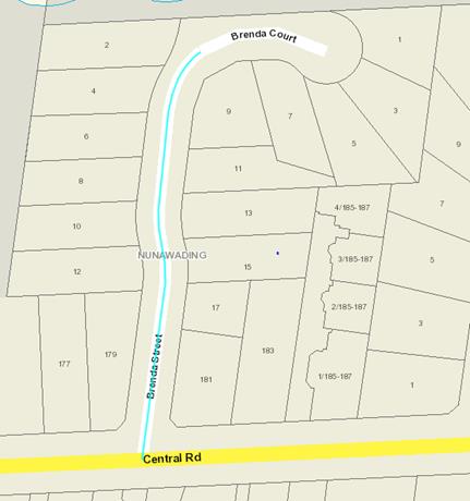
APPENDIX 2
Photograph of entry signs to Brenda Street/Court,
Nunawading
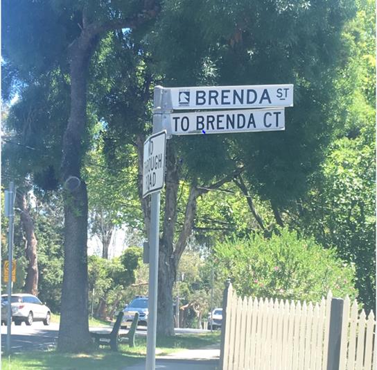
Ordinary Council Minutes 25
February 2019
9.2.5 Councillor
Appointments to Organisations and Community Bodies
FILE
NUMBER: SF09/28
SUMMARY
Council at its meeting held 19
November 2018 appointed Councillor representatives for the 2018/2019 period for
various committees, organisations and community bodies. Cr Stennett has
advised of his intention to withdraw as a Councillor representative on the
following Committees:
· Audit
Advisory Committee
· Heritage
Steering Committee
· Whitehorse
Reconciliation Policy and Action Plan Advisory Committee
As a result of Cr
Stennett’s withdrawal, it is recommended that Council appoint a
Councillor representative to these Committees.
background
Councillor representative
appointments to various committees, organisations and community bodies are made
by Council each year in October/November, as well as other times throughout the
year as required when new committees or groups are established or when a
vacancy arises.
Council at its meeting held 19
November 2018 appointed Councillor representatives for the 2018/2019 year.
Cr Stennett has advised he is
withdrawing as a Councillor representative on the Audit Advisory Committee,
Heritage Steering Committee and Whitehorse Reconciliation Policy and Action
Plan Advisory Committee. A vacancy now exists for each of these
committees and it is recommended that Council appoint a Councillor
representative.
DISCUSSION
It is suggested Council consider
and resolve appointments to those committees as detailed in Appendix A below.
APPENDIX A:
Councillor Representative Appointments to
the Following Bodies
(for the period 25 February to 18 November 2019)
INTERNAL COMMITTEES
|
#
|
BODY
|
COUNCILLOR REPRESENTATIVE 2018/2019
|
|
11
|
Audit Advisory Committee
(Two Councillors)
|
Cr Denise Massoud
(1 x vacancy) Cr Carr appointed
|
|
12
|
Heritage Steering Committee
(Two Councillors)
|
Cr Prue Cutts
(1 x vacancy) Cr Davenport appointed
|
|
15
|
Whitehorse Reconciliation Policy &
Action Plan Advisory Committee
(One Councillor as Chair)
|
(1 x vacancy as Chair) Cr Massoud
appointed
|
Ordinary Council Minutes 25
February 2019
9.2.6 Delegated
Decisions December 2018
SUMMARY
The following activity was undertaken by officers under
delegated authority during December 2018.
|
DELEGATION
|
FUNCTION
|
Number for December 2017
|
Number for December 2018
|
|
Planning and Environment Act
1987
|
Delegated Decisions
|
112
|
133
|
|
Strategic Planning Decisions
|
Nil
|
1
|
|
Telecommunications Act 1997
|
|
Nil
|
Nil
|
|
Subdivision Act 1988
|
|
29
|
18
|
|
Gaming Control Act 1991
|
|
Nil
|
Nil
|
|
Building Act 1993
|
Dispensations & Applications to
Building Control Commission
|
62
|
51
|
|
Liquor Control Reform Act 1998
|
Objections and Prosecutions
|
1
|
1
|
|
Food Act 1984
|
Food Act Orders
|
2
|
3
|
|
Public Health & Wellbeing
Act 2008
|
Improvement /
Prohibition Notices
|
2
|
2
|
|
Local Government Act 1989
|
Temporary Rd. Closures
|
1
|
4
|
|
Other Delegations
|
CEO Signed Contracts between $150,000 - $750,000
|
2
|
5
|
|
Property Sales and Leases
|
6
|
8
|
|
Documents to which Council seal affixed
|
3
|
Nil
|
|
Vendor Payments
|
1162
|
1147
|
|
Parking Amendments
|
13
|
7
|
|
Parking Infringements written off
|
191
|
253
|
DELEGATED DECISIONS MADE ON PLANNING APPLICATIONS DECEMBER
2018
All decisions are the subject of conditions which may in
some circumstances alter the use of development approved, or specific grounds
of refusal is an application is not supported.
|
Appl No.
|
Date
|
Decision
|
Street
Address
|
Ward
|
Proposed Use or Development
|
Application
Type
|
|
WH/2018/1216
|
13-12-18
|
Application Lapsed
|
15 Market Street Box Hill Vic 3128
|
Elgar
|
Buildings and works (alteration to shop front)
|
Business
|
|
WH/2018/379
|
19-12-18
|
Application Lapsed
|
31 Fuchsia Street Blackburn Vic 3130
|
Central
|
Construction of one double storey dwelling cary out
works an associated tree removal
|
Special Landscape Area
|
|
WH/2018/447
|
04-12-18
|
Application Lapsed
|
13-25 Strabane Avenue Mont Albert North Vic 3129
|
Elgar
|
Removal of protected SLO9 trees and Native Vegetation
|
Vegetation Protection Overlay
|
|
WH/2018/593
|
19-12-18
|
Application Lapsed
|
934-940 Whitehorse Road Box Hill Vic 3128
|
Elgar
|
Display of Business Identification signage
|
Advertising Sign
|
|
WH/2018/977
|
21-12-18
|
Application Lapsed
|
42 Nurlendi Road Vermont Vic 3133
|
Morack
|
Buildings and works (retaining walls and landscaping)
wiithin 4m of a protected tree and construction of a front fence.
|
Special Landscape Area
|
|
WH/2001/12637/A
|
13-12-18
|
Delegate Approval - S72 Amendment
|
Kiosk 170-180 Rooks Road Vermont Vic 3133
|
Springfield
|
To develop and use the land for the purpose of
On-Premise Liquor licence
|
Permit Amendment
|
|
WH/2003/13990/F
|
04-12-18
|
Delegate Approval - S72 Amendment
|
1/880 Canterbury Road Box Hill South Vic 3128
|
Riversdale
|
Amendment to plans endorsed Planning Permit
WH/2003/13990 isssued for the development of the land for a three storey
building in association with the use of a shop, displaying of advertising
signs and alterations to a Road Zone, Category 1
|
Permit Amendment
|
|
Appl No.
|
Date
|
Decision
|
Street
Address
|
Ward
|
Proposed Use or Development
|
Application
Type
|
|
WH/2012/512/C
|
27-12-18
|
Delegate Approval - S72 Amendment
|
34 Dorking Road Box Hill Vic 3128
|
Elgar
|
Construction of 221 bed residential aged care
facility and ancillary adult day over three levels plus basement in two
stages, and associated removal of a tree (Tree 77) within the Significant
Landscape Overlay Schedule 9
|
Permit Amendment
|
|
WH/2014/730/A
|
28-12-18
|
Delegate Approval - S72 Amendment
|
1/76-78 Mahoneys Road Forest Hill Vic 3131
|
Central
|
Construction of six (6) double storey dwellings and
consolidation of land into one lot
|
Permit Amendment
|
|
WH/2014/929/A
|
14-12-18
|
Delegate Approval - S72 Amendment
|
241 Warrigal Road Burwood Vic 3125
|
Riversdale
|
Extension of four dwellings on a lot and alteration
of access to a road in a Road Zone (Category 1)
|
Permit Amendment
|
|
WH/2015/219/A
|
18-12-18
|
Delegate Approval - S72 Amendment
|
65 Severn Street Box Hill North Vic 3129
|
Elgar
|
Construction of a three (3) storey building
comprising six (6) dwellings
|
Permit Amendment
|
|
WH/2016/471/A
|
17-12-18
|
Delegate Approval - S72 Amendment
|
78 Railway Road Blackburn Vic 3130
|
Central
|
Buildings and works construction of flues and a
reduction in car parking associated with the use of the land for a restaurant
(cafe)
|
Permit Amendment
|
|
WH/2016/709/A
|
17-12-18
|
Delegate Approval - S72 Amendment
|
7 Hotham Court Mont Albert Vic 3127
|
Elgar
|
Construction of two double storey dwellings
|
Permit Amendment
|
|
WH/2016/806/A
|
03-12-18
|
Delegate Approval - S72 Amendment
|
16 Cadorna Street Box Hill South Vic 3128
|
Riversdale
|
Construction of two double storey dwellings on a lot
|
Permit Amendment
|
|
WH/2017/562/A
|
06-12-18
|
Delegate Approval - S72 Amendment
|
22 Stanley Street
Box Hill South Vic 3128
|
Riversdale
|
The construction of two (2) double storey dwellings
|
Permit Amendment
|
|
Appl No.
|
Date
|
Decision
|
Street
Address
|
Ward
|
Proposed Use or Development
|
Application
Type
|
|
WH/2017/613/A
|
04-12-18
|
Delegate Approval - S72 Amendment
|
20 Broughton Road Surrey Hills Vic 3127
|
Riversdale
|
Amendment of plans and conditions for Planning permit
WH/2017/613 for Construction of new double storey dwelling with garage to the
rear of existing dwelling to include visitor carspace for Dwelling 2
|
Permit Amendment
|
|
WH/2017/679/A
|
06-12-18
|
Delegate Approval - S72 Amendment
|
364 Burwood Highway Burwood Vic 3125
|
Riversdale
|
Construction of a five storey apartment building
above basement, reduction in parking and alteration of access to a road in a
road zone category 1
|
Permit Amendment
|
|
WH/2018/1112/A
|
19-12-18
|
Delegate Approval - S72 Amendment
|
8-12 Simla Street Mitcham Vic 3132
|
Springfield
|
Use of part of the land for the purpose of a
commercial kitchen
|
Permit Amendment
|
|
WH/2018/58/A
|
20-12-18
|
Delegate Approval - S72 Amendment
|
5 Grove Street Vermont Vic 3133
|
Springfield
|
Construction of a Dwelling and associated Tree
Removal
|
Permit Amendment
|
|
WH/2017/340/A
|
19-12-18
|
Delegate NOD - S72 Amendment
|
18 Winjallock Crescent Vermont South Vic 3133
|
Morack
|
Construction of a double storey dwelling at the rear
of an existing dwelling, buildings and works within 4 metres of vegetation,
vegetation removal.
|
Permit Amendment
|
|
WH/2017/861
|
10-12-18
|
Delegate NOD Issued
|
295 Whitehorse Road Nunawading Vic 3131
|
Springfield
|
Construction of a Two Storey Building with Basement,
Reduction in Statutory Car Parking Requirements and Alteration of Access to a
Road in a Road Zone, Category 1
|
Business
|
|
WH/2017/919/A
|
27-12-18
|
Delegate NOD Issued
|
303 Springvale Road Forest Hill Vic 3131
|
Springfield
|
Use and development of land Child Care Centre and
display of advertising signage
|
Permit Amendment
|
|
Appl No.
|
Date
|
Decision
|
Street
Address
|
Ward
|
Proposed Use or Development
|
Application
Type
|
|
WH/2017/978
|
07-12-18
|
Delegate NOD Issued
|
35 Landale Street Box Hill Vic 3128
|
Elgar
|
Demolition of the existing dwelling and front fence
and construction of new dwelling and front fence within a Heritage Overlay,
and removal of protected trees
|
Heritage
|
|
WH/2018/1110
|
06-12-18
|
Delegate NOD Issued
|
Corner Burwood Hwy & Hunter Valley Rd Vermont
South
|
Morack
|
Construct and display two (2) internally illuminated
promotion signs
|
Advertising Sign
|
|
WH/2018/1166
|
06-12-18
|
Delegate NOD Issued
|
Bus Stop 8670 Corner Station St & Devon St Box
Hill South
|
Riversdale
|
Display two (2) internally-illuminated promotion
advertising signs (Bus stop id 8670)
|
Advertising Sign
|
|
WH/2018/1167
|
10-12-18
|
Delegate NOD Issued
|
Bus Stop 8248 Corner Burwood Hwy & Fankhauser
Drive Vermont Sth
|
Morack
|
Display two internally illuminated promotional signs
|
Advertising Sign
|
|
WH/2018/1168
|
13-12-18
|
Delegate NOD Issued
|
Bus Stop 8670 Nth side of Burwood Hwy Burwood East
|
Riversdale
|
Display two (2) internally illuminated static
promotion signs (Bus stop id 8245)
|
Advertising Sign
|
|
WH/2018/1174
|
12-12-18
|
Delegate NOD Issued
|
Corner of Burwood Highway and Warrington Avenue,
Vermont South. Bus stop id 8250
|
Morack
|
Display two advertising signs comprising of two
internally illuminated promotion signs near the corner of Burwood Highway and
Warrington Avenue, Vermont South. Bus stop id 8250
|
Advertising Sign
|
|
WH/2018/1175
|
06-12-18
|
Delegate NOD Issued
|
Bus Stop 5262 Corner Station St & Whitehorse Rd Blackburn
|
Central
|
Construct and display two (2) internally illuminated
promotion signs
|
Advertising Sign
|
|
WH/2018/1176
|
06-12-18
|
Delegate NOD Issued
|
Bus Stop 21323 Corner Springvale & Walkers Rd
Nunawading
|
Springfield
|
Display of two internally illuminated promotion signs
near the corner of Springvale Road and Walkers Road, Nunawading (Bus stop id
21323)
|
Advertising Sign
|
|
Appl No.
|
Date
|
Decision
|
Street
Address
|
Ward
|
Proposed Use or Development
|
Application
Type
|
|
WH/2018/1177
|
10-12-18
|
Delegate NOD Issued
|
Bus Stop 21254 Corner Whitehorse Rd & Simpson Rd
Box Hill
|
Elgar
|
Display two internally illuminated promotional signs.
Bus stop 21254.
|
Advertising Sign
|
|
WH/2018/1178
|
14-12-18
|
Delegate NOD Issued
|
Bus Stop 16677 adjacent to 5 Boronia Rd Vermont
|
Springfield
|
Display two (2) internally illuminated static
promotion signs (Bus stop id 16677)
|
Advertising Sign
|
|
WH/2018/1179
|
06-12-18
|
Delegate NOD Issued
|
Bus Stop 15722 Canterbury Rd Vermont
|
Springfield
|
Construct and display two (2) internally illuminated
promotion signs
|
Advertising Sign
|
|
WH/2018/1180
|
06-12-18
|
Delegate NOD Issued
|
Bus Stop 13668 Corner Springvale Rd & Hawthorn Rd
Vermont Sth
|
Morack
|
Display two advertising signs comprising of two
internally illuminated promotion signs near the corner of Springvale Road and
Hawthorn Road, Vermont South (Bus stop id 13668)
|
Advertising Sign
|
|
WH/2018/1182
|
18-12-18
|
Delegate NOD Issued
|
Bus Stop 12524 Corner Springvale Rd & Pindary
Place Forest Hill
|
Riversdale
|
Display two (2) internally illuminated promotion
signs (Bus stop id 12524)
|
Advertising Sign
|
|
WH/2018/1183
|
06-12-18
|
Delegate NOD Issued
|
Bus Stop 12518 Springvale Rd Forest Hill
|
Morack
|
Construct and display two (2) internally illuminated
promotion signs
|
Advertising Sign
|
|
WH/2018/1185
|
10-12-18
|
Delegate NOD Issued
|
Bus Stop 11498 Canterbury Rd Vermont
|
Springfield
|
Display two internally illuminated promotional signs
|
Advertising Sign
|
|
WH/2018/286
|
04-12-18
|
Delegate NOD Issued
|
5 Olympic Court Forest Hill Vic 3131
|
Central
|
The construction of two, double storey dwellings, buildings
and works within 4 metres of vegetation (seven trees), vegetation removal
(one tree).
|
Multiple Dwellings
|
|
WH/2018/378
|
12-12-18
|
Delegate NOD Issued
|
36 Finch Street Burwood Vic 3125
|
Riversdale
|
Construction of a second dwelling on a lot, removal
and buildings and works within 4m of protected trees
|
Multiple Dwellings
|
|
Appl No.
|
Date
|
Decision
|
Street
Address
|
Ward
|
Proposed Use or Development
|
Application
Type
|
|
WH/2018/448
|
20-12-18
|
Delegate NOD Issued
|
16 Johnston Street Burwood Vic 3125
|
Riversdale
|
Construction of three, two storey dwellings,
buildings and works within 4 metres of the base of a protected tree and the
removal of a protected tree under the provisions of Schedule 9 to the
Significant Landscape Overlay (SLO9)
|
Multiple Dwellings
|
|
WH/2018/495
|
11-12-18
|
Delegate NOD Issued
|
8 Albion Road
Box Hill Vic 3128
|
Elgar
|
Buildings and works (double storey dwelling and front
fencing) within 4 metres of protected trees
|
Special Landscape Area
|
|
WH/2018/499
|
07-12-18
|
Delegate NOD Issued
|
64 Surrey Road
Blackburn North Vic 3130
|
Central
|
Construction of two double storey dwellings, two lot
subdivision and associated removal of trees within the Significant Landscape
Overlay Schedule 9 and alteration of access to a road in a Road Zone,
Category 1
|
Multiple Dwellings
|
|
WH/2018/517
|
12-12-18
|
Delegate NOD Issued
|
7 Barter Crescent Forest Hill Vic 3131
|
Morack
|
Development of the land for three (3) new dwellings,
including associated tree removal and buildings and works.
|
Multiple Dwellings
|
|
WH/2018/541
|
10-12-18
|
Delegate NOD Issued
|
380 Middleborough Road Blackburn Vic 3130
|
Central
|
Buildings and works associated with the construction
of four three storey dwellings and associated tree removal
|
Multiple Dwellings
|
|
WH/2018/556
|
03-12-18
|
Delegate NOD Issued
|
14 Edinburgh Street Box Hill South Vic 3128
|
Riversdale
|
Development of the land for three (3) double storey
dwellings including associated buildings and works within 4 metres of
protected trees and tree removal
|
Multiple Dwellings
|
|
Appl No.
|
Date
|
Decision
|
Street
Address
|
Ward
|
Proposed Use or Development
|
Application
Type
|
|
WH/2018/606
|
12-12-18
|
Delegate NOD Issued
|
9 Willcyrus Street Surrey Hills Vic 3127
|
Elgar
|
Construction of two double storey dwellings, removal
of and buildings and works within 4m of protected trees
|
Multiple Dwellings
|
|
WH/2018/670
|
13-12-18
|
Delegate NOD Issued
|
459 Station Street Box Hill Vic 3128
|
Elgar
|
Buildings and works associated with a medical centre
(retention of existing medical centre use) and alteration of access to a road
in a Road Zone, Category 1, and removal of trees protected under the
Significant Landscape Overlay Schedule 9
|
Residential (Other)
|
|
WH/2018/708
|
31-12-18
|
Delegate NOD Issued
|
4 Ripon Court Forest Hill Vic 3131
|
Springfield
|
Development of the land for two (2) double storey dwellings,
including associated buildings and works within 4 metres of protected trees
and tree removal
|
Multiple Dwellings
|
|
WH/2018/812
|
11-12-18
|
Delegate NOD Issued
|
142 Dorking Road Box Hill North Vic 3129
|
Elgar
|
Removal of vegetation
|
Special Landscape Area
|
|
WH/2018/835
|
28-12-18
|
Delegate NOD Issued
|
1 Cooinda Court Burwood East Vic 3151
|
Riversdale
|
Construction of two double storey dwellings,
buildings and works, and associated vegetation removal
|
Multiple Dwellings
|
|
WH/2018/892
|
06-12-18
|
Delegate NOD Issued
|
1 Ngumby Court Vermont South Vic 3133
|
Morack
|
Removal of nine (9) trees within the Significant
Landscape Overlay Schedule 9, including the removal of two (2) native trees
under Clause 52.17
|
Vegetation Protection Overlay
|
|
WH/2017/857
|
04-12-18
|
Delegate Permit Issued
|
1 Everton Grove Surrey Hills Vic 3127
|
Riversdale
|
Construction of two double storey dwellings
(including alterations and extensions of existing dwelling) and vegetation
removal
|
Multiple Dwellings
|
|
Appl No.
|
Date
|
Decision
|
Street
Address
|
Ward
|
Proposed Use or Development
|
Application
Type
|
|
WH/2018/1026
|
10-12-18
|
Delegate Permit Issued
|
270 Canterbury Road Forest Hill Vic 3131
|
Central
|
To construct and display internally illuminated,
Business Identification and Major Promotion signage.
|
Advertising Sign
|
|
WH/2018/1029
|
04-12-18
|
Delegate Permit Issued
|
37 Saxton Street Box Hill North Vic 3129
|
Elgar
|
2 lot subdivision
|
VicSmart - Subdivision
|
|
WH/2018/1053
|
04-12-18
|
Delegate Permit Issued
|
7 Lewis Court Nunawading Vic 3131
|
Springfield
|
Two Lot Subdivision
|
Subdivision
|
|
WH/2018/1077
|
07-12-18
|
Delegate Permit Issued
|
220 Middleborough Road Blackburn South Vic 3130
|
Central
|
Minor buildings and works to residential aged care
facility
|
Residential (Other)
|
|
WH/2018/1121
|
21-12-18
|
Delegate Permit Issued
|
18 Weber Crescent Burwood East Vic 3151
|
Riversdale
|
Removal of two (2) trees
|
Special Landscape Area
|
|
WH/2018/1161
|
17-12-18
|
Delegate Permit Issued
|
1 Main Street Box Hill Vic 3128
|
Elgar
|
Buildings and works to alter the existing facade and
display of Illuminated advertising signs
|
Advertising Sign
|
|
WH/2018/1186
|
20-12-18
|
Delegate Permit Issued
|
Bus Stop 11495 Sherman St, Corner Stevens Rd Forest
Hill
|
Morack
|
Display two (2) internally illuminated promotion
signs (Bus stop id 11495)
|
Advertising Sign
|
|
WH/2018/1213
|
10-12-18
|
Delegate Permit Issued
|
49 Lemon Grove Nunawading Vic 3131
|
Springfield
|
Buildings and works (construct a garage) within 4
metres of protected vegetation
|
VicSmart - General Application
|
|
WH/2018/1224
|
17-12-18
|
Delegate Permit Issued
|
1/15 Thomas Street Mitcham Vic 3132
|
Springfield
|
Buildings and works to allow for the construction of
a garage
|
VicSmart - General Application
|
|
WH/2018/123
|
31-12-18
|
Delegate Permit Issued
|
277 Springvale Road Nunawading Vic 3131
|
Springfield
|
Construction of three (two storey) dwellings, removal
of vegetation, buildings and works within 4 metres of trees, and alteration
of access to a Road Zone Category 1
|
Multiple Dwellings
|
|
Appl No.
|
Date
|
Decision
|
Street
Address
|
Ward
|
Proposed Use or Development
|
Application
Type
|
|
WH/2018/1254
|
05-12-18
|
Delegate Permit Issued
|
Tram Shelter 6462 Burwood Hwy Near Keats St,
|
Riversdale
|
Construct and display two (2) internally illuminated
promotional signs
|
Advertising Sign
|
|
WH/2018/1255
|
05-12-18
|
Delegate Permit Issued
|
Tram Shelter 6465 Burwood Rd, Burwood East near Blackburn
Rd, Burwood East
|
Morack
|
Construct and display four (4) internally illuminated
promotional signs
|
Advertising Sign
|
|
WH/2018/1260
|
21-12-18
|
Delegate Permit Issued
|
1 Chapman Street Blackburn North Vic 3130
|
Central
|
Removal of 2 trees
|
Special Landscape Area
|
|
WH/2018/1265
|
03-12-18
|
Delegate Permit Issued
|
3 Norris Court Blackburn Vic 3130
|
Central
|
Removal of Protected Tree (SLO2)
|
VicSmart - Tree
|
|
WH/2018/1269
|
03-12-18
|
Delegate Permit Issued
|
4 Arawatta Street Vermont South Vic 3133
|
Morack
|
Removal of vegetation
|
VicSmart - Tree
|
|
WH/2018/1287
|
03-12-18
|
Delegate Permit Issued
|
1a Baldwin Road Blackburn Vic 3130
|
Central
|
Buildings and works assoicated with the construction
of a front fence
|
VicSmart - General Application
|
|
WH/2018/1293
|
05-12-18
|
Delegate Permit Issued
|
13 Alandale Road Blackburn Vic 3130
|
Central
|
Dangerous tree - remove tree as the lean will keep
getting worse and roots will fail
|
VicSmart - Tree
|
|
WH/2018/1294
|
06-12-18
|
Delegate Permit Issued
|
117 Central Road Blackburn Vic 3130
|
Central
|
Removal of vegetation
|
VicSmart - Tree
|
|
WH/2018/1297
|
04-12-18
|
Delegate Permit Issued
|
15 Benjamin Street Box Hill North Vic 3129
|
Elgar
|
Remove a Tree (SLO9)
|
VicSmart - Tree
|
|
WH/2018/1300
|
03-12-18
|
Delegate Permit Issued
|
730 Canterbury Road Surrey Hills Vic 3127
|
Riversdale
|
Buildings and works ( additional wall vents, windows
and access ramps) associated with an existing telecommunication facility.
|
VicSmart - General Application
|
|
WH/2018/1303
|
12-12-18
|
Delegate Permit Issued
|
10 Frances Avenue Vermont Vic 3133
|
Morack
|
Removal of one (1) tree within SLO9
|
VicSmart - Tree
|
|
WH/2018/1313
|
10-12-18
|
Delegate Permit Issued
|
14 Cumberland Court Forest Hill Vic 3131
|
Springfield
|
Removal of one (1) tree within SLO9
|
VicSmart - General Application
|
|
Appl No.
|
Date
|
Decision
|
Street
Address
|
Ward
|
Proposed Use or Development
|
Application
Type
|
|
WH/2018/1314
|
10-12-18
|
Delegate Permit Issued
|
14 Cumberland Court Forest Hill Vic 3131
|
Springfield
|
Removal of one (1) tree within SLO9
|
VicSmart - General Application
|
|
WH/2018/1315
|
10-12-18
|
Delegate Permit Issued
|
14 Cumberland Court Forest Hill Vic 3131
|
Springfield
|
Removal of one (1) tree within SLO9
|
VicSmart - General Application
|
|
WH/2018/1318
|
12-12-18
|
Delegate Permit Issued
|
4 Tulkara Grove Vermont Vic 3133
|
Morack
|
Removal of one (1) tree
|
VicSmart - Tree
|
|
WH/2018/1319
|
12-12-18
|
Delegate Permit Issued
|
399 Elgar Road Mont Albert Vic 3127
|
Elgar
|
Removal of one (1) tree within SLO9
|
VicSmart - Tree
|
|
WH/2018/1324
|
14-12-18
|
Delegate Permit Issued
|
14 Ashmore Road Forest Hill Vic 3131
|
Morack
|
Removal of four (4) trees & buildings and works
within 4 metres of protected vegetation
|
Special Landscape Area
|
|
WH/2018/1328
|
12-12-18
|
Delegate Permit Issued
|
3 Halley Street Blackburn Vic 3130
|
Central
|
Removal of one tree
|
VicSmart - Tree
|
|
WH/2018/1330
|
07-12-18
|
Delegate Permit Issued
|
1a Deanswood Road Forest Hill Vic 3131
|
Central
|
Removal of one (1) tree within SLO9
|
VicSmart - Tree
|
|
WH/2018/1334
|
14-12-18
|
Delegate Permit Issued
|
34 Samuel Road Blackburn South Vic 3130
|
Riversdale
|
Removal of one tree only
|
VicSmart - Tree
|
|
WH/2018/1344
|
4-12-18
|
Delegate Permit Issued
|
14 Salvana Avenue Mitcham Vic 3132
|
Springfield
|
Buildings and works (construct an alfresco) within 4
metres of protected vegetation
|
VicSmart - General Application
|
|
WH/2018/1355
|
27-12-18
|
Delegate Permit Issued
|
24 Sevenoaks Road Burwood East Vic 3151
|
Morack
|
removal of one tree
|
VicSmart - Tree
|
|
WH/2018/1368
|
21-12-18
|
Delegate Permit Issued
|
31 Uganda Street Burwood Vic 3125
|
Riversdale
|
Removal of protected tree
|
VicSmart - Tree
|
|
WH/2018/1372
|
27-12-18
|
Delegate Permit Issued
|
4 Victory Street Mitcham Vic 3132
|
Springfield
|
Removal of a tree
|
VicSmart - Tree
|
|
WH/2018/1373
|
24-12-18
|
Delegate Permit Issued
|
4 Bridgeford Avenue Blackburn North Vic 3130
|
Central
|
Removal of one (1) tree within SLO9
|
VicSmart - Tree
|
|
Appl No.
|
Date
|
Decision
|
Street
Address
|
Ward
|
Proposed Use or Development
|
Application
Type
|
|
WH/2018/1378
|
18-12-18
|
Delegate Permit Issued
|
2/13 Skene Street Burwood East Vic 3151
|
Riversdale
|
Removal of one (1) tree within SLO9
|
VicSmart - Tree
|
|
WH/2018/1382
|
24-12-18
|
Delegate Permit Issued
|
77 Rostrevor Parade Mont Albert North Vic 3129
|
Elgar
|
Removal of one (1) tree within SLO9
|
VicSmart - Tree
|
|
WH/2018/1389
|
31-12-18
|
Delegate Permit Issued
|
7 Bambra Court Vermont Vic 3133
|
Morack
|
Removal of vegetation
|
VicSmart - General Application
|
|
WH/2018/239
|
14-12-18
|
Delegate Permit Issued
|
15 Milford Avenue Burwood Vic 3125
|
Riversdale
|
Use of the land for a carpark and buildings and works
within 4 metres of trees
|
Education
|
|
WH/2018/260
|
20-12-18
|
Delegate Permit Issued
|
104-168 Hawthorn Road Forest Hill Vic 3131
|
Morack
|
Subdivision of land into 14 residential lots,
roadways and common property and development of dwellings on 11 lots and
alteration of access to a Road Zone Category 1.
|
Multiple Dwellings
|
|
WH/2018/334
|
17-12-18
|
Delegate Permit Issued
|
39 Pope Road Blackburn Vic 3130
|
Central
|
Construction of two, double storey dwellings and
associated garages and the removal of vegetation
|
Multiple Dwellings
|
|
WH/2018/459
|
07-12-18
|
Delegate Permit Issued
|
48 Husband Road Forest Hill Vic 3131
|
Morack
|
Development of One New Double Storey Dwelling at Rear
of Existing Dwelling and Removal of Vegetation
|
Multiple Dwellings
|
|
WH/2018/460
|
05-12-18
|
Delegate Permit Issued
|
22 Albert Street Mitcham Vic 3132
|
Springfield
|
To remove two trees
|
Special Landscape Area
|
|
WH/2018/471
|
20-12-18
|
Delegate Permit Issued
|
302 Station Street Box Hill South Vic 3128
|
Riversdale
|
Buildlings and works (for construction of a double
storey dwelling) and tree removal within the SLO9
|
Special Landscape Area
|
|
WH/2018/508
|
27-12-18
|
Delegate Permit Issued
|
3 Karen Street Box Hill North Vic 3129
|
Elgar
|
Development of the land for two (2), new dwellings,
including associated buildings and works and tree removal.
|
Multiple Dwellings
|
|
WH/2018/561
|
04-12-18
|
Delegate Permit Issued
|
27 Evelina Street Mont Albert North Vic 3129
|
Elgar
|
Three lot subdivision
|
Subdivision
|
|
Appl No.
|
Date
|
Decision
|
Street
Address
|
Ward
|
Proposed Use or Development
|
Application
Type
|
|
WH/2018/616
|
14-12-18
|
Delegate Permit Issued
|
29 Farleigh Avenue Burwood Vic 3125
|
Riversdale
|
The development of the land for three (3) double
storey dwellings, including associated buildings and works within 4 metres of
protected trees and tree removal
|
Multiple Dwellings
|
|
WH/2018/644
|
05-12-18
|
Delegate Permit Issued
|
3 Davy Lane Forest Hill Vic 3131
|
Morack
|
Removal and replacement of two trees on the north
western fence line
|
Special Landscape Area
|
|
WH/2018/646
|
07-12-18
|
Delegate Permit Issued
|
2 Proudfoot Street Mont Albert Vic 3127
|
Elgar
|
Buildings and works (alterations to existing
dwelling) and vegetation removal.
|
Heritage
|
|
WH/2018/772
|
10-12-18
|
Delegate Permit Issued
|
2-18 Canterbury Road Blackburn South Vic 3130
|
Central
|
Replacement of existing sign with an electronic sign
|
Advertising Sign
|
|
WH/2018/773
|
10-12-18
|
Delegate Permit Issued
|
786 Whitehorse Road Mont Albert Vic 3127
|
Elgar
|
Replacement of an existing sign with an electronic
sign
|
Advertising Sign
|
|
WH/2018/774
|
10-12-18
|
Delegate Permit Issued
|
486-488 Springvale Road Forest Hill Vic 3131
|
Morack
|
Replacement of existing sign with electronic sign
|
Advertising Sign
|
|
WH/2018/775
|
10-12-18
|
Delegate Permit Issued
|
612-626 Canterbury Road Vermont Vic 3133
|
Morack
|
Replace existing sign with electronic sign
|
Advertising Sign
|
|
WH/2018/811
|
21-12-18
|
Delegate Permit Issued
|
9 Howard Street
Mitcham Vic 3132
|
Springfield
|
Removal of 3 trees
|
Special Landscape Area
|
|
WH/2018/815
|
21-12-18
|
Delegate Permit Issued
|
16 Central Road Blackburn Vic 3130
|
Central
|
Demolition of existing dwelling and buildings and
works to construct a single dwelling and tree removal
|
Vegetation Protection Overlay
|
|
WH/2018/87
|
19-12-18
|
Delegate Permit Issued
|
23 Mckean Street BOX HILL NORTH VIC 3129
|
Elgar
|
Construction of four, double storey dwellings and
tree removal and buildings and works within 4 metres of a protected tree
within SLO9
|
Multiple Dwellings
|
|
Appl No.
|
Date
|
Decision
|
Street
Address
|
Ward
|
Proposed Use or Development
|
Application
Type
|
|
WH/2018/921
|
04-12-18
|
Delegate Permit Issued
|
428 Springvale Road Forest Hill Vic 3131
|
Morack
|
Removal of vegetation and associated works within a
SLO9, works, Variation of Access to a Road Zone (R1Z) and associated signage
|
Special Landscape Area
|
|
WH/2018/941
|
04-12-18
|
Delegate Permit Issued
|
10 Bell Street Box Hill North Vic 3129
|
Elgar
|
Construction of two (2) double storey dwellings on a
lot with vegetation removal and buildings and works within 4 metres of
protected vegetation
|
Multiple Dwellings
|
|
WH/2018/943
|
13-12-18
|
Delegate Permit Issued
|
8 Stevens Road Forest Hill Vic 3131
|
Morack
|
Removal of 1 Tree
|
Special Landscape Area
|
|
WH/2018/947
|
04-12-18
|
Delegate Permit Issued
|
175 Springfield Road Blackburn North Vic 3130
|
Central
|
To subdivide in accordance to the proposed plan of
subdivision
|
Subdivision
|
|
WH/2018/968
|
04-12-18
|
Delegate Permit Issued
|
14 Paul Avenue Box Hill North Vic 3129
|
Elgar
|
Six lot subdivision
|
Subdivision
|
|
WH/2018/981
|
13-12-18
|
Delegate Permit Issued
|
10a Alexander Street Mitcham Vic 3132
|
Springfield
|
Removal of trees within SLO9
|
Special Landscape Area
|
|
WH/2017/1041
|
07-12-18
|
Delegate Refusal Issued
|
20 Pearce Street Burwood Vic 3125
|
Riversdale
|
Construction of two dwellings comprising one triple
storey and one double storey
|
Multiple Dwellings
|
|
WH/2018/1134
|
12-12-18
|
Delegate Refusal Issued
|
44 Morrie Crescent Blackburn North Vic 3130
|
Central
|
Removal of two (2) trees
|
Special Landscape Area
|
|
WH/2018/1301
|
14-12-18
|
Delegate Refusal Issued
|
23 Cresswell Crescent Mitcham Vic 3132
|
Springfield
|
Removal of One Tree
|
VicSmart - Tree
|
|
WH/2018/251
|
06-12-18
|
Delegate Refusal Issued
|
16 The Mews Vermont Vic 3133
|
Morack
|
Construction of three, two storey dwellings,
buildigns and works within 4 metres of a tree and removal of trees within
Schedule 9 to the Significant Landscape Overlay
|
Multiple Dwellings
|
|
Appl No.
|
Date
|
Decision
|
Street
Address
|
Ward
|
Proposed Use or Development
|
Application
Type
|
|
WH/2018/313
|
17-12-18
|
Delegate Refusal Issued
|
54 Barossa Avenue Vermont South Vic 3133
|
Morack
|
Construction of Four (4) Double Storey Dwellings
within a Special Building Overlay and Removal of Vegetation
|
Multiple Dwellings
|
|
WH/2018/509
|
12-12-18
|
Delegate Refusal Issued
|
589 Elgar Road Mont Albert North Vic 3129
|
Elgar
|
Construction of two dwellings and associated removal
of trees and buildings and works within four metres of trees protected under
the Significant Landscape Overlay Schedule 9 and alteration of access to a
Road Zone, Category 1
|
Multiple Dwellings
|
|
WH/2018/721
|
07-12-18
|
Delegate Refusal Issued
|
1 Orient Avenue Mitcham Vic 3132
|
Springfield
|
The proposal seeks approval for the use and
development of a child care centre, associated tree removal (SLO9 and VPO4)
and buildings and works within 4 metres of protected trees (SLO9)
|
Child Care Centre
|
|
WH/1997/9232/A
|
19-12-18
|
No Permit Required
|
519 Elgar Road Mont Albert North Vic 3129
|
Elgar
|
Construction of one additiona dwelling at the rear of
an existing dwelling, with construction of carport for existing dwelling
|
Permit Amendment
|
|
WH/2018/1267
|
12-12-18
|
No Permit Required
|
321 Mont Albert Road Mont Albert Vic 3127
|
Elgar
|
Proposed construction of new brick fence within 4
metres of protected trees.
|
VicSmart - General Application
|
|
WH/2018/1275
|
04-12-18
|
No Permit Required
|
592 Station Street Box Hill Vic 3128
|
Elgar
|
Reduction in car parking requirement
|
VicSmart - General Application
|
|
WH/2018/1285
|
03-12-18
|
No Permit Required
|
1/44 Cadorna Street Box Hill South Vic 3128
|
Riversdale
|
Removal of vegetation
|
VicSmart - Tree
|
|
WH/2018/1306
|
03-12-18
|
No Permit Required
|
21a Alwyn Street Mitcham Vic 3132
|
Springfield
|
Removal of vegetation
|
VicSmart - Tree
|
|
Appl No.
|
Date
|
Decision
|
Street
Address
|
Ward
|
Proposed Use or Development
|
Application
Type
|
|
WH/2013/873/A
|
20-12-18
|
Withdrawn
|
11 Lindsay Avenue Nunawading Vic 3131
|
Springfield
|
Construction of a double storey dwelling to the rear
of an existing dwelling
|
Permit Amendment
|
|
WH/2016/245/B
|
05-12-18
|
Withdrawn
|
9 Reid Street Box Hill North Vic 3129
|
Elgar
|
2 unit development
|
Permit Amendment
|
|
WH/2018/1023
|
13-12-18
|
Withdrawn
|
15-33 Alfred Street Blackburn Vic 3130
|
Central
|
Buildings and works associated with the conversion of
part of the existing warehouse for use as a minor sports and recreation
facility including provision of car parking to the satisfaction of the
responsible authority.
|
Industrial
|
|
WH/2018/1243
|
18-12-18
|
Withdrawn
|
15-33 Alfred Street Blackburn Vic 3130
|
Central
|
Install new lift adjacent to existing stairs to
existing mezzanine level office entry. New canopy to new lift
|
Industrial
|
|
WH/2018/1358
|
10-12-18
|
Withdrawn
|
24 Sevenoaks Road Burwood East Vic 3151
|
Morack
|
(Lodged in error refer WH/2018/1355) removal of one
tree on north fence
|
VicSmart - Tree
|
|
WH/2018/945
|
19-12-18
|
Withdrawn
|
12 Sunhill Avenue Burwood Vic 3125
|
Riversdale
|
Buildings and works within 4 metres of protected
vegetation
|
VicSmart - General Application
|
BUILDING
DISPENSATIONS/APPLICATIONS DECEMBER 2018
|
10 Fir Street, Blackburn
|
21-12-18
|
Central
|
Consent Granted 81
|
|
194 Blackburn Road, Blackburn South
|
13-12-18
|
Central
|
Consent Granted 89
|
|
2 Julie Street, Blackburn North
|
27-12-18
|
Central
|
Consent Granted 92
|
|
20 Pakenham Street, Blackburn
|
05-12-18
|
Central
|
Consent Granted 89
|
|
220 Middleborough Road, Blackburn South
|
10-12-18
|
Central
|
Consent Granted 89,91
|
|
25 Charlotte Street, Blackburn South
|
06-12-18
|
Central
|
Consent Granted 74
|
|
25 Middlefield Drive, Blackburn North
|
21-12-18
|
Central
|
Consent Granted 89
|
|
30 Junction Road, Blackburn North
|
20-12-18
|
Central
|
Consent Granted 79
|
|
37 Maple Street, Blackburn
|
04-12-18
|
Central
|
Consent Granted 82
|
|
45 Faulkner Street, Forest Hill
|
06-12-18
|
Central
|
Consent Granted 79
|
|
69 Canterbury Road, Blackburn
|
19-12-18
|
Central
|
Consent Granted 79
|
|
7 Eustace Street, Blackburn
|
04-12-18
|
Central
|
Consent Granted 75
|
|
85 Koonung Road, Blackburn North
|
04-12-18
|
Central
|
Consent Granted 89
|
|
10 Fir Street, Blackburn
|
20-12-18
|
Central
|
Consent Refused 83
|
|
13 Harold Street, Blackburn
|
24-12-18
|
Central
|
Consent Refused 89
|
|
1/92 Windsor Crescent, Surrey Hills
|
07-12-18
|
Elgar
|
Consent Granted 79
|
|
4 Hood Street, Mont Albert
|
10-12-18
|
Elgar
|
Consent Granted 79
|
|
40 Rutland Road, Box Hill
|
24-12-18
|
Elgar
|
Consent Granted 116
|
|
53 Melrose Street, Mont Albert North
|
27-12-18
|
Elgar
|
Consent Granted 79
|
|
6 Rowland Street, Mont Albert
|
12-12-18
|
Elgar
|
Consent Granted 85
|
|
61 Severn Street, Box Hill North
|
14-12-18
|
Elgar
|
Consent Granted 116
|
|
1/92 Windsor Crescent, Surrey Hills
|
07-12-18
|
Elgar
|
Consent Refused 94
|
|
14 Gordon Street, Mont Albert
|
28-12-18
|
Elgar
|
Consent Refused 79
|
|
2 Market Street, Box Hill
|
28-12-18
|
Elgar
|
Consent Refused 116
|
|
1/34 Terrara Road, Vermont
|
20-12-18
|
Morack
|
Consent Granted 76, 79
|
|
106 Jolimont Road, Vermont
|
10-12-18
|
Morack
|
Consent Granted 74
|
|
27 Lusk Drive, Vermont
|
10-12-18
|
Morack
|
Consent Granted 76, 79
|
|
50 Parkmore Road, Forest Hill
|
06-12-18
|
Morack
|
Consent Refused 74
|
|
11 Naples Street, Box Hill South
|
14-12-18
|
Riversdale
|
Consent Granted 74
|
|
15 Oak Street, Surrey Hills
|
13-12-18
|
Riversdale
|
Consent Granted 89
|
|
18 Byron Street, Box Hill South
|
05-12-18
|
Riversdale
|
Consent Granted 74, 79
|
|
34 Fulton Road, Blackburn South
|
21-12-18
|
Riversdale
|
Consent Granted 76
|
|
17 Holroyd Court, Blackburn South
|
20-12-18
|
Riversdale
|
Consent Refused 89
|
|
11 Good Governs Street, Mitcham
|
20-12-18
|
Springfield
|
Consent Granted 76
|
|
2/112 Springvale Road, Nunawading
|
20-12-18
|
Springfield
|
Consent Granted 74
|
|
2/13 Grey Street, Vermont
|
21-12-18
|
Springfield
|
Consent Granted 76, 77
|
|
21 Sunshine Avenue, Mitcham
|
19-12-18
|
Springfield
|
Consent Granted 76, 79
|
|
3 Wattle Valley Road, Mitcham
|
19-12-18
|
Springfield
|
Consent Granted 79, 74, 76
|
|
44 Rosstrevor Crescent, Mitcham
|
06-12-18
|
Springfield
|
Consent Granted 74, 79
|
|
7 Forest Road, Forest Hill
|
12-12-18
|
Springfield
|
Consent Granted 74
|
|
21 Sunshine Avenue, Mitcham
|
19-12-18
|
Springfield
|
Consent Refused 80
|
|
3 Greenwood Court, Vermont
|
11-12-18
|
Springfield
|
Consent Refused 79
|
DELEGATED DECISIONS
MADE ON STRATEGIC PLANNING MATTERS DECEMBER 2018
Under the Planning and Environment Act 1987: Nil
|
Decision Date
|
Act Section
|
Decision
|
Street Address
|
Ward
|
Proposal
|
Reference
|
|
11/12/18
|
8A(3)
and 20(1)
|
Delegate Approval
|
42-48 Glenburnie Road, Mitcham
|
Springfield
|
A request for report and consent to demolish
the property under section 29A of the Building Act 1993 has necessitated a
request to the Minister for Planning for an interim Heritage Overlay on 42-48
Glenburnie Road, Mitcham. The delegate report also decides to seek
authorisation to prepare and exhibit an amendment for a permanent Heritage
Overlay on the site. The site was identified for potential heritage
significance in the Whitehorse Heritage Review 2001 and the Whitehorse
Heritage Review 2012.
|
Amendment C215 and C216
|
REGISTER OF CONTRACTS
SIGNED BY CEO DELEGATION DECEMBER 2018
|
Contract
Number
|
Service
|
|
30019
|
Harrow
Street Car Park Construction
|
|
30103
|
Forest Hill Reserve Cricket Nets Construction
|
|
30020
|
Nunawading
Community Hub
|
|
30076/1
|
Traffic
Survey Services
|
|
30076/4
|
Traffic
Survey Services
|
REGISTER OF PROPERTY
DOCUMENTS EXECUTED DECEMBER 2018
|
Property Address
|
Document Type
|
Document Detail
|
|
Leases
|
|
|
|
Suite 2/1 Main Street Box Hill (Box Hill Central South Precinct)
|
Lease
|
New lease (Existing lease expired)
|
|
23 Surrey Drive, Box Hill
|
Lease
|
Renewal of lease (exercising option to renew)
|
|
Land Transfers
|
|
|
|
Part of discontinued road at rear of 52 Clyde Street, Box Hill
North
|
Client Authorisation for Transfer of Land
|
Sale of Discontinued Road
Section 207D Local Government Act 1989
|
|
Part of discontinued road at rear of 52 Clyde Street, Box Hill
North
|
Goods Statutory Declaration
|
Duties Act 2000
|
|
Part of discontinued road at rear of 527 Mitcham Road, Vermont
|
Client Authorisation for Transfer of Land
|
Transfer of Discontinued Road
Section 207D Local Government Act 1989
|
|
Part of discontinued road at rear of 527 Mitcham Road, Vermont
|
Goods Statutory Declaration
|
Duties Act 2000
|
|
Fire Services Property Levy (FSPL)
|
|
|
|
28 Edgerton Road, Mitcham
|
Not applicable
|
Land use changed from 'Industrial' to 'Exempt'
|
|
Rateability Changes
(Section 154 of the Local Government Act)
|
|
|
|
28 Edgerton Road, Mitcham
|
Exempt-Commonwealth Land
|
Purchased by Indigenous Business Australia
|
REGISTER OF DOCUMENTS AFFIXED
WITH THE COUNCIL SEAL DECEMBER 2018
Nil
PARKING
RESTRICTIONS APPROVED BY DELEGATION DECEMBER 2018
Address: Clare
Street, Blackburn: from northern boundary
of 4 Clare Street to northern boundary of 12 Clare Street – west side
Previously: 6 ‘Unrestricted’ parking spaces
Now: 6 temporary ‘1-Hour, 9am to 6pm, Monday to
Friday’ parking spaces
Address: 55
Purches Street, Mitcham: from western boundary of 55 Purches Street to eastern boundary of 55 Purches Street – north side
Previously: 2 ‘Works Zone, 7am to 5pm, Monday to Saturday’
parking spaces
Now: 2 ‘Unrestricted’ parking spaces
Address: Gardenia
Street, Blackburn: from southern boundary
of 4a Gardenia Street to18m north of the southern boundary of 4a Gardenia
Street – west side
Previously: 3 ‘1-Hour, 8am to 6pm, Monday to Saturday’
parking spaces
Now: 3 temporary 'Bus Zone' parking spaces
Address: Heatherdale
Road, Mitcham: from 15m north of Kulnine
Avenue to 33m north of Kulnine Avenue – west side
Previously: 2 ‘2-Hour, 8am to 6pm, Monday to Friday’
parking spaces
Now: 2 ‘Unrestricted’ parking spaces
Address: The
Avenue, Blackburn: from Main Street to
Gardenia Street – north side
Previously: 8 ‘No Stopping’ parking spaces
Now: 8 temporary 'Bus Zone' parking spaces
Address: The
Avenue, Blackburn: from Main Street to
Gardenia Street – south side
Previously: 8 ‘2-Hour, 8am to 6pm, Monday to Friday’
parking spaces
Now: 8 temporary ‘No Stopping ' parking spaces
Address: Blackburn
Road, Blackburn: from Southern boundary of
30 Blackburn Road to northern boundary of 30 Blackburn Road – west side
Previously: 6 ‘1-Hour, 8am to 6pm, Monday to Friday & 8am to
1pm, Saturday’ parking spaces
Now: 6
temporary ‘Bus Zone' parking spaces
VENDOR PAYMENT SUMMARY
– SUMS PAID DURING DECEMBER 2018
|
Date
|
Total
Issued
|
Payments
(direct debit, cheques or electronic funds transfer)
|
Transaction Type EFT/CHQ/DD
|
|
06/12/2018
|
$8,938.72
|
18
|
EFC
|
|
06/12/2018
|
$140,180.49
|
18
|
CHQ
|
|
06/12/2018
|
$352,966.90
|
42
|
EFT
|
|
06/12/2018
|
$144.00
|
1
|
EFC
|
|
07/12/2018
|
$24,991.48
|
1
|
EFT
|
|
11/12/2018
|
$38,497.50
|
1
|
EFT
|
|
13/12/2018
|
$8,498.06
|
24
|
EFC
|
|
13/12/2018
|
$62,479.91
|
24
|
CHQ
|
|
13/12/2018
|
$1,690,030.61
|
327
|
EFT
|
|
14/12/2018
|
$2,491,318.05
|
1
|
EFT
|
|
17/12/2018
|
$90.85
|
1
|
EFC
|
|
18/12/2018
|
$226,840.90
|
1
|
EFT
|
|
18/12/2018
|
$9,754.80
|
1
|
EFT
|
|
19/12/2018
|
$1,423,962.65
|
1
|
EFT
|
|
19/12/2018
|
$165.00
|
1
|
EFT
|
|
20/12/2018
|
$4,581.85
|
17
|
EFC
|
|
20/12/2018
|
$60,574.55
|
36
|
CHQ
|
|
20/12/2018
|
$1,852,243.72
|
262
|
EFT
|
|
20/12/2018
|
$3,600.00
|
1
|
CHQ
|
|
21/12/2018
|
$786,325.82
|
1
|
EFT
|
|
21/12/2018
|
$372,726.20
|
1
|
EFT
|
|
27/12/2018
|
$1,306.40
|
6
|
EFC
|
|
27/12/2018
|
$96,018.10
|
46
|
CHQ
|
|
27/12/2018
|
$4,115,790.84
|
315
|
EFT
|
|
|
|
|
|
GROSS
|
$13,772,027.40
|
1147
|
|
|
|
|
|
|
Monthly
Lease Payments
|
$36,330.05
|
|
|
|
Direct
Debit Payments
|
$163,102.47
|
|
|
|
CANCELLED
PAYMENTS
|
-$7,693.35
|
-24
|
|
|
NETT
|
$13,963,766.57
|
1123
|
|
Ordinary Council Minutes 25
February 2019
10 Reports
from Delegates, Special Committee Recommendations and Assembly of Councillors
Records
10.1 Reports
by Delegates
NB: Reports only
from Councillors appointed by Council as delegates to community
organisations/committees/groups)
|
10.1.1 Cr Liu reported on her
attendance at the:
·
Eastern
Transport Coalition meeting held on the 20 February 2019.
·
Whitehorse
Manningham Regional Library Corporation meeting held on the 20 February 2019.
·
Eastern
Alliance for Greenhouse Action Executive Committee meeting held on the 21
February 2019.
|
|
10.1.2 Cr Barker reported on his
attendance at the Domestic Animal Management Plan Advisory Committee held on
the 20 February 2019.
|
|
10.13 Cr Ellis reported on
her attendance at the:
·
Eastern
Region Affordable Housing Alliance meeting held on the 7 February 2019.
·
Eastern
Region Group meeting held on the 22 February 2019.
|
|
10.1.4 Cr Carr reported on her
attendance at the Domestic Animal Management Plan Advisory Committee held on
the 20 February 2019.
|
|
10.1.5 Cr Massoud reported on her
attendance at the:
·
Disability
Advisory Committee meeting held on the 6 February 2019.
·
Whitehorse
Sport and Recreation Network meeting held on the 21 February 2019.
|
|
10.1.6 Cr Cutts reported on her
attendance at the Whitehorse Manningham Regional Library Corporation
meeting held on the 20 February 2019.
|
|
10.1.7 Cr Bennett reported on his
attendance at the:
·
Local
Government Waste Management Forum to support the Metropolitan Waste
Management group meeting held on 21 February 2019.
·
Eastern
Region Group meeting held on the 22 February 2019.
|
10.2 Recommendation
from the Special Committee of Council Meeting of 11 February 2019
Ordinary Council Minutes 25
February 2019
10.3 Record
of Assembly of Councillors
|
Meeting Date
|
Matter/s Discussed
|
Councillors
Present
|
Officers Present
|
Disclosures of Conflict of Interest
|
Councillor /Officer attendance following disclosure
|
|
29.01.18
6:30-7:00pm
|
Councillor Informal Briefing Session
· 9.1.1
25 Holland Road, Blackburn Sth (Lot 1TP 599873E)
· 9.1.3
Residential Corridors Built Form Study
· Staffing
Matter
|
Cr Bennett
(Mayor & Chair)
Cr Barker
Cr Carr
Cr Cutts
Cr Davenport
Cr Ellis
Cr Liu
Cr Massoud arrived at 6:40pm)
Cr Munroe
|
N Duff
J Green
N Brown
T Wilkinson
P Smith
S Freud
A De Fazio
R Anania
|
Nil
|
Nil
|
|
04.02.19
6:30-9:15pm
|
Strategic Planning Session
· Significant
Landscape Overlay Controls
· Councillor
Correspondence Management
· Matsudo Book
· Budget Update
|
Cr Bennett
(Mayor & Chair)
Cr Barker
Cr Carr
Cr Cutts
Cr Davenport
Cr Ellis
Cr Liu
Cr Massoud (arrived at 6:40pm)
Cr Munroe
Cr Stennett
|
N Duff
J Green
N Brown
T Wilkinson
P Smith
S Freud
A De Fazio
K Marriott
A Egan
V McLean
P Warner
S Cann
|
Nil
|
Nil
|
|
11.02.19
6:30-10:30pm
|
Councillor Briefing Session
· Proposed Developments & Probity
· Special Committee Agenda 11 Feb 2018
· Other Business
Motions
· Impact of East
Link on sports fields
· Draft Council
Agenda 25 Feb 2019
|
Cr Bennett
(Mayor & Chair)
Cr Barker
Cr Carr
Cr Cutts (left the meeting at 8:30pm
& did not return)
Cr Davenport
Cr Ellis
Cr Liu (left the meeting at 8:30pm &
did not return)
Cr Massoud
Cr Munroe
Cr Stennett
|
N Duff
J Green
N Brown
T Wilkinson
P Smith
S Freud
A De Fazio
K Marriott
J Hansen
A Egan
V McLean
I Kostopoulos
I Barnes
M Kerr
L Mcguiness
J White
|
Ms T Wilkinson declared a probity Conflict
of Interest in Item 9.1.1 2-4 Bruce Street, Box Hill.
|
Ms T Wilkinson having declared a probity
Conflict of Interest in Item 9.1.1 2-4 Bruce Street,
Box Hill, left the meeting at
8:50pm prior to discussion on the item returning at 8:59pm.
|
|
18.02.19
6:30- 10:30pm
|
Major Project Councillor Reference Group:
Finance: Capital Works
|
Cr Bennett
(Mayor & Chair)
Cr Barker
Cr Carr
Cr Cutts
Cr Davenport
Cr Ellis
Cr Liu
Cr Massoud
Cr Munroe
Cr Stennett
|
N Duff
J Green
N Brown
T Wilkinson
P Smith
A De Fazio
M Ackland
S Cann
S Smith
T McGuckian
S Hewett
|
Cr Carr declared an indirect Conflict of
Interest in Item 3.2(a) as she is a board member of Family Access Network.
|
Cr Carr having declared an indirect
Conflict of Interest in in Item 3.2(a),
left the meeting at 6:35pm prior to discussion on
the item. Returning at 6:45pm.
|
11 Reports
on Conferences/Seminars Attendance
11.1 Cr
Cutts reported on attendance at the CEDA Women in Leadership Forum held on the
14 February 2019.
11.2 Cr
Massoud reported on her attendance at the AICD Leader Edge Lunch held on the 22
February 2019.
12 Confidential
Reports
|
Council Resolution
Moved by Cr Munroe,
Seconded by Cr Liu
That in accordance with Section 89 (2) (h) and
(e) of the Local Government Act 1989 the Council should resolve to go into camera
and close the meeting to the public as the matters to be dealt with relate to
any other matter which the Council or special committee considers would
prejudice the Council or any person and proposed developments.
Carried
|
The meeting was closed to the
public at 9:28pm.
Attendance
Cr Barker left the Chamber at 9:28pm,
returning at 9:30pm
12.1 Proposed Development 1
12.2 Proposed
Development 2
The meeting was reopened to the
public at 10:27pm.
13 Close
Meeting
Meeting closed at 10:29pm
Confirmed this 18th day
of March 2019
_______________________________
CHAIRPERSON