Ordinary
Council Meeting
Held in the
Council Chamber
Whitehorse Civic Centre
379 Whitehorse Road Nunawading
on
Monday 16 September 2019
at 7:00pm
Members: Cr
Bill Bennett (Mayor), Cr Blair Barker, Cr Raylene Carr,
Cr Prue Cutts, Cr Andrew Davenport, Cr Sharon Ellis, Cr Tina
Liu,
Cr
Denise Massoud, Cr Andrew Munroe, Cr Ben Stennett
Mr Simon McMillan
Chief Executive Officer
|
Recording of Meeting and Disclaimer
Please
note every Ordinary Council Meeting (other than items deemed confidential
under section 89(2) of the Local Government Act 1989) is being recorded and
streamed live on Whitehorse City Council’s website in accordance with
Council's Live Streaming and Recording of Meetings Policy. A copy of the
policy can also be viewed on Council’s website.
The recording will be archived and made publicly
available on Council's website within 48 hours after the meeting on
www.whitehorse.vic.gov.au for a period of three years (or as otherwise agreed
to by Council).
Live streaming allows everyone to watch and listen to
the meeting in real time, giving you greater access to Council debate and
decision making and encouraging openness and transparency.
All
care is taken to maintain your privacy; however, as a visitor in the public
gallery, your presence may be recorded. By remaining in the public gallery,
it is understood your consent is given if your image is inadvertently
broadcast.
Opinions expressed or
statements made by individual persons during a meeting are not the opinions
or statements of Whitehorse City Council. Council therefore accepts no
liability for any defamatory remarks that are made during a meeting.
|
Ordinary Council Minutes 16
September 2019
TABLE OF CONTENTS
1 PRAYER. 3
2 WELCOME
AND APOLOGIES. 3
3 DISCLOSURE
OF CONFLICT OF INTERESTS. 3
4 CONFIRMATION
OF MINUTES OF PREVIOUS MEETINGS. 4
5 RESPONSES
TO QUESTIONS. 4
6 Notices
of Motion.. 4
6.1 Notice
of Motion No 124: Cr Stennett. 4
6.2 Notice
of Motion No 125: Cr Stennett. 4
7 Petitions. 5
7.1 Parking
Restriction Changes to Eram Road, First Avenue and Cherry Orchard Rise,
Box Hill North. 5
8 Urgent
Business. 5
9 Council
Reports. 6
9.1 City
Development. 6
Statutory Planning
9.1.1 408
& 410 Burwood Highway, Vermont South (Lot 3 & 4 LP 84340) Buildings and
works for the construction of a five storey apartment building for two or more
dwellings, and associated tree removal. 6
9.1.2 2
Sergeant Street, Blackburn (Lot 11 LP 6826) Construction of a four storey
apartment building, buildings and works within 4 metres of protected trees
(SLO9). 46
9.1.3 92
Kenmare Street, Mont Albert (Lot 98 LP 8375) Construction of three double
storey dwellings with basement garages and associated tree removal. 82
Strategic Planning
9.1.4 Amendment
C219: Permanent Significant Landscape Overlay, Schedule 9, Review of
Submissions 103
9.1.5 Heritage
Advisor Annual Report 2018-2019. 125
9.1.6 Strategic
Planning Update. 133
Engineering and Environmental
9.1.7 Landfill
disposal contract for Whitehorse and Metropolitan Waste and Resource Recovery
Group collective contract 141
9.2 Infrastructure. 148
9.2.1 Tender
Evaluation (Contract 30193) Elgar Park Southern Ovals Improvement. 148
9.3 Corporate. 150
9.3.1 Electoral
Representation Review 2019: Council's Response Submission. 150
9.3.2 Proposal
to name unnamed right of way abutting 3 Clarke Street and the rear of
7-19 Gordon Crescent, Blackburn. 153
9.3.3 Delegated
Decisions July 2019. 159
10 Reports
from Delegates, Special Committee Recommendations and Assembly of Councillors
Records 182
10.1 Reports
by Delegates. 182
10.2 Recommendation
from the Special Committee of Council Meeting of 9 September
2019. 183
10.3 Record
of Assembly of Councillors. 184
11 Reports
on Conferences/Seminars Attendance. 185
12 Confidential
Reports. 185
13 Close
Meeting.. 186
Ordinary Council Minutes 16
September 2019
Meeting opened at 7.00pm
Present: Cr Bennett (Mayor), Cr Barker, Cr
Carr, Cr Cutts, Cr Davenport
Cr
Ellis, Cr Liu, Cr Massoud, Cr Munroe
1 PRAYER
1a Prayer
for Council
We give thanks, O God, for the Men and
Women of the past whose generous devotion to the common good has been the
making of our City.
Grant that our own generation may build
worthily on the foundations they have laid.
Direct our minds that all we plan and
determine, is for the wellbeing of our City.
Amen.
1b Aboriginal
Reconciliation Statement
“In the spirit of reconciliation
Whitehorse City Council acknowledges the Wurundjeri people as the traditional
custodians of the land we are meeting on. We pay our respects to their
Elders past and present.”
2 WELCOME
AND APOLOGIES
The Mayor welcomed all
APOLOGIES:
Cr Stennett has sought a leave
of absence for tonight’s Ordinary Council Meeting 16 September 2019.
RECOMMENDATION
Moved by Cr
Cutts, Seconded by Cr Ellis
That the apology for Cr
Stennett be received and leave of absence be granted for tonight’s
Ordinary Council Meeting 16 September 2019.
CARRIED UNANIMOUSLY
3 DISCLOSURE
OF CONFLICT OF INTERESTS
None disclosed
4 CONFIRMATION
OF MINUTES OF PREVIOUS MEETINGS
Minutes of the Ordinary Council Meeting 26 August
2019 and Confidential Ordinary Council Meeting 26 August 2019
5 RESPONSES
TO QUESTIONS
|
5.1 Ms D Kopecek, Box Hill North submitted
two questions relating to Amendment C219
|
|
|
The
Chief Executive Officer Simon McMillan responded to Ms Kopecek and advised
that a written response will be provided.
|
|
5.2 Ms
A Salmon, Mitcham submitted two questions relating to the Nunawading Mega
Mile review and the town planning meeting process
|
|
|
The
Chief Executive Officer Simon McMillan responded to Ms Salmon’s
questions.
|
6 Notices
of Motion
6.1 Notice of Motion No 124:
Cr Stennett
|
That Council
allow the Mitcham Sporting Clubs operating at Walker Park to extend the
liquor licence in their temporary marquee to 10:30pm on a Friday, Saturday and
Sunday evening.
LAPSED
|
6.2 Notice of Motion No 125:
Cr Stennett
|
Council
Resolution
Moved by Cr Davenport
That Council:
1. Note a signalised pedestrian crossing has
been constructed across Springvale Road Nunawading at the Nunawading Station
2. Write to VicRoads, thanking them for
constructing this crossing, as part of the Box Hill to Ringwood Shared Path,
however also express its concerns to VicRoads about the number of pedestrian
crossings and distance between them
3. Request
VicRoads undertake a review of the signalised crossings on Springvale Road
Nunawading between Central Road and Whitehorse Road, considering the
possibility of removing the pedestrian crossing at the Nunawading Post
Office.
LAPSED for want of a Seconder
|
7 Petitions
7.1 Parking Restriction
Changes to Eram Road, First Avenue and Cherry Orchard Rise, Box Hill North
A petition signed by 29 signatories has been received
requesting Council to change parking restrictions in Eram Road, First Avenue
and Cherry Orchard Rise Box Hill North.
8 Urgent
Business
None.
Ordinary Council Minutes 16
September 2019
9 Council
Reports
9.1 City
Development
Statutory Planning
9.1.1 408 &
410 Burwood Highway, Vermont South (Lot 3 & 4 LP 84340) Buildings and works
for the construction of a five storey apartment building for two or more
dwellings, and associated tree removal
FILE NUMBER: WH/2018/1270
ATTACHMENT
SUMMARY
This application was advertised
on 20 March 2019, and 1 objection was received. The objection raised issues
with traffic, noise, and tree impacts (impacts to landscape and habitat). A
Consultation Forum was not required due to the number of objections received.
This application was called-in to Council for a decision by the Ward
Councillors.
This report assesses the
application against the relevant provisions of the Whitehorse Planning Scheme,
as well as the objector concerns. It is recommended that the application
be supported, subject to conditions.
|
RECOMMENDATION
That Council:
A. Being the Responsible Authority, having
caused Application WH/2018/1270 at 408 and 410 Burwood Highway, Vermont South
(Lot 3 and 4 LP 84340), to be advertised and having received and noted the
objection is of the opinion that the granting of the current Planning Permit
for Buildings and works for the construction of a five storey apartment
building, and associated tree removal, is acceptable and should not
unreasonably impact the amenity of adjacent properties.
B. Issue a Notice of
Decision to Grant a Permit under the Whitehorse Planning Scheme to the land
described as 408 and 410 Burwood Highway, VERMONT SOUTH (LOT 3 and 4 LP
84340) which allows the ‘Buildings and works for the Construction of a
five storey apartment building, and associated tree removal, subject to the
following conditions:
1. Before the
development starts, or vegetation removed, amended plans shall be submitted
to and approved by the Responsible Authority in a digital format. When
approved, the plans will be endorsed and will then form part of the
permit. The plans must be drawn scale, and be generally in accordance
with the without prejudice plans dated July 2019, referenced as
‘180117’, drawn by Clarke Hopkins, submitted with the application
but modified to show:
a) The
maximum building height reduced to 13.5 metres across the site, and otherwise
reduced to 14.5 metres when the land slopes greater
than 2.5 degrees
b) The yellow colour tone for the north-western
corner of the approved building (affects the front and eastern side
elevations in part), muted to alleviate the visual dominance of the building
to boundary interfaces.
c) Side facing snorkel windows for dwellings
1.01, 1.05, 2.01 and 2.05, with a depth not exceeding 1.5 metres.
d) Dwelling G01 with the following modifications:
i. The
living area and front bedrooms on the ground floor reversed.
ii. A
suitably dimensioned entry foyer provided east of the reversed living area,
extending up to the front-facing window of the reversed front bedroom.
iii. The main
entry doorway, compliant with Standards D9 and D18 of Clause 58,
re-orientated to face eastwards of the entry foyer required by Condition
1d)(ii).
iv. A pathway
from the modified front entry required by Condition 1d)(iii), running along
the front building wall of the reversed front bedroom, then heading north to
the front boundary. The front boundary fence must be modified to delineate
the front private open space area from the pathway, along with a graduated
height reduction to 1.2 metres. Any changes to the planter box, landscaping,
front gate, and current pathway alignment are included as part of this
condition.
v. Noise
attenuation measures provided for the eastern building wall and rear entry
door interfacing with the carpark.
vi. Appropriate
ventilation measures ensuring that any vehicular fumes do not enter into the
floor space of this dwelling.
e) The locations of Tree Protection Zones as
described in Condition 5, with all nominated trees clearly identified and
numbered on both site and landscape plans, and the requirements of conditions
4 and 5 to be annotated on the development and landscape plans.
f) A Construction Management Plan in accordance
with Condition 11.
g) Notation that all treatments to prevent
overlooking must not include ‘Translucent film’ on windows and
must be in accordance with Standard B22 of Clause 55.
h) The landscape plan updated to:
i. Include a 6 month
maintenance plan.
ii. Include a maintenance
schedule of how all plants, including planter boxes will be maintained.
iii. Accommodate reflect all
relevant Condition 1 requirements.
i) An updated Sustainability Management Plan in
accordance with Condition 7.
j) Development plans to reflect all
sustainability features indicated in the Sustainability Management Plan required
by Condition 7
k) The Waste Management Plan as required by
Condition 12, revised to include the following additional detail:
i. A plan to confirm a nominated
vehicle position to carry out bin collection in the accessway.
ii. Written confirmation that collection
must take place during nominated time brackets outside peak periods, to the
satisfaction of the Responsible Authority.
2. The layout of the site and the size, design
and location of the buildings and works permitted must always accord with the
endorsed plan and must not be altered or modified without the further written
consent of the Responsible Authority.
Landscaping and Tree Protection
3. Unless with the prior written consent, all
tree planting and landscaping works as shown on the endorsed plans must be
completed prior to the occupation of the development to the satisfaction of
the Responsible Authority.
4. The garden areas shown on the endorsed plan
must only be used as gardens and must be maintained in a proper, tidy and
healthy condition to the satisfaction of the Responsible Authority.
Should any tree or shrub be removed or destroyed it may be required to be
replaced by a tree or shrub of similar size and variety.
5. Prior to commencement of any building or
demolition works on the land, a Tree Protection Zones (TPZs) must be
established on the subject site (and nature strip if required) and maintained
during, and until completion of, all buildings and works including
landscaping, around the following trees in accordance with the distances and
measures specified below, to the satisfaction of the Responsible Authority:
a) Tree Protection Zone
distances:
i. Tree 1 – Chamaecyparis lawsoniana
– 3.4 metres radius.
ii. Tree 6 – Prunus cerasifera – 6.48
metres radius.
iii. Tree 7 – Viburnum tinus – 2.0 metres
radius.
iv. Tree 8 – Prunus cerasifera – 5.88
metres radius.
v. Tree 9 – Cotoneaster glaucophylla
– 2 metres radius.
vi. Tree 10 – Cotoneaster glaucophylla
– 4.2 metres radius.
vii. Tree 11 – Photinia x fraseri –
4.56 metres radius.
viii. Tree 12 – Waterhousia floribunda –
2.0 metres radius.
ix. Tree 14 (in part) – Chamaecyparis
lawsoniana – 2.76 metres radius.
x. Tree 18 – Picea abies – 3.24
metres radius.
b) Tree Protection Zone
measures are to be established in accordance with Australian Standard
4970-2009 and are to include the following:
i.
Erection of solid chain
mesh or similar type fencing at a minimum height of 1.8 metres in height held
in place with concrete feet.
ii.
Signage placed around the
outer edge of perimeter the fencing identifying the area as a TPZ. The
signage should be visible from within the development, with the lettering
complying with AS 1319.
iii.
Mulch across the surface
of the TPZ to a depth of 100mm and undertake supplementary provide
watering/irrigation within the TPZ, prior and during any works performed.
iv.
No excavation,
constructions works or activities, grade changes, surface treatments or
storage of materials of any kind are permitted within the TPZ unless
otherwise approved within this permit or further approved in writing by the
Responsible Authority.
v.
All supports and bracing
should be outside the TPZ and any excavation for supports or bracing should
avoid damaging roots where possible.
vi.
No trenching is allowed
within the TPZ for the installation of utility services unless tree sensitive
installation methods such as boring have been approved by the Responsible
Authority.
vii.
Where construction is
approved within the TPZ, fencing and mulching should be placed at the outer
point of the construction area.
viii.
Where there are approved
works within the TPZ, it may only be reduced to the required amount by an
authorized person only during approved construction within the TPZ, and must
be restored in accordance with the above requirements at all other times.
Boundary Wall
6. Prior to the occupation of the development,
all boundary walls must be constructed, cleaned and finished to the
satisfaction of the Responsible Authority.
Sustainability Management Design
7. Prior to the commencement of any buildings or
demolition works, an amended Sustainability Management Plan (SMP) must be
submitted to an approved by the Responsible Authority. This SMP must be
generally in accordance with the SMP submitted with the application but
amended to include the following changes:
a) A STORM Rating Report
with a score of at least 100% or equivalent demonstrating that rainwater
tanks are sized accordingly to ensure reliability/efficiency whilst
minimising potential overflow.
b) A complete, published
BESS Report, with an acceptable overall score that exceeds 50% and exceed the
‘pass’ marks in the categories of Water, Energy Stormwater and
Indoor Environment Quality (IEQ).
c) Provide Preliminary
NatHERS Assessments for 20% of the total amount of dwellings a part of the
development. Ensure that the energy efficiency provisions of the
Apartment Design Guidelines for Victoria 2017 are satisfied.
d) Provide glazing
specifications including SHGC, VLT and U-values and ensure that such values
are consistent with Preliminary NatHERS and energy efficiency specifications,
as well as, Development Plans.
e) Control car park
ventilation with CO sensors.
f) Control car park
lighting (at least 75% of lighting fixtures) with motion sensors.
g) Commit to controlling all
external, common, service and lift area lighting with sensors/timers.
h) Commit to controlling
common, service and lift area ventilation with sensors/timers.
i) Commit to the
inclusion of energy efficient heating, cooling and hot water systems
indicating the associated COP and EER values and/or star ratings.
j) Commit to the
inclusion of water efficient fixtures and appliances indicating the
associated WELS ratings.
k) Connect the rainwater
tanks to all toilet flushing systems.
l) Commit to diverting
at least 80% of construction/demolition waste from landfill.
m) Submit a water balance calculation
justifying the rainwater tank capacity, based on long-term average rainfall
data, collection areas and expected end uses, which is in compliance with
AS/NZS 6400:2016 of 1 full- and 4 half-flushes per person per day (providing
17.5 L/person/day for a 4 star WELS rated toilet). A rainwater tank
size should be selected based on calculations, ensuring adequate reliability
of supply is maintained with respect to managing potential overflow and
considering the development’s potable water demand. The rainwater
tank should cater for all toilet flushing systems and service irrigative
areas.
Once submitted and approved to the satisfaction of the
Responsible Authority, the SMP will form part of the endorsed plans under
this permit.
8. All works must be undertaken in accordance
with the endorsed SMP to the satisfaction of the Responsible Authority, and
the approved dwellings must operate in accordance with this Plan, to the
satisfaction of the Responsible Authority. No alterations to the
Reports may occur without the written consent of the Responsible Authority.
Building Services
9. All building plant and equipment on the roofs,
balcony areas, common areas, and public thoroughfares is to be concealed to
the satisfaction of the Responsible Authority. Noise emitting plant equipment
such as air conditioners, must be shielded with acoustic screening to prevent
the transmission of noise having detrimental amenity impacts. The
construction of any additional plant, machinery or other equipment, including
but not limited to all service structures, down pipes, aerials, satellite
dishes, telecommunication facilities, air-conditioners, equipment, ducts,
flues, all exhausts including car parking and communication equipment must
include appropriate screening measures to the satisfaction of the Responsible
Authority.
10. The development must be provided with external
lighting capable of illuminating access to each garage and car parking space.
Lighting must be located, directed and shielded and of limited intensity that
no nuisance or loss of amenity is caused to any person within and beyond the
site.
Construction Management Plan
11. Prior to the and commencement of buildings or
works on the land, a Construction Management Plan, prepared by an experienced
person or firm, detailing how the owner will manage the environmental and
construction issues associated with the development, must be submitted to and
approved by Council. The Construction Management Plan must be prepared
in consultation with Council’s Engineering and Environmental Services
Department, Building Department, ParksWide (Arboricultural) Department and
Community Laws Department.
Once
submitted to and approved by the Responsible Authority, the Construction
Management Plan will form part of the documents endorsed as part of this
planning permit. When approved the Construction Management Plan must be
complied with, to the satisfaction of the Responsible Authority, to the
extent that this is in the control of the owner of the land. The owner
of the land is to be responsible for all costs associated with the works to
be undertaken in accordance with the requirements of the Construction and
Traffic Management Plans.
Waste Management
12. The requirements of the Waste Management Plan
prepared by Leigh Design, dated 1st November 2018, must be
implemented by the building manager, owners and occupiers of the site for the
duration of the building’s operation in accordance with this permit, to
the satisfaction of the Responsible Authority.
Assets Protection
13. All storm water drains and on-site detention
systems are to be connected to the legal point of discharge to the
satisfaction of the Responsible Authority prior to the occupation of the
building/s. The requirement for on- site detention will be noted on
your storm water point of discharge report, or it might be required as part
of the civil plans approval.
14. Detailed storm water drainage and/or civil
design for the proposed development are to be prepared by a suitably
qualified civil engineer and submitted to the Responsible Authority for
approval prior to occupation of the development. Plans and calculations
are to be submitted with the application with all levels to Australian Height
Datum (AHD). All documentation is to be signed by the qualified civil
engineer.
15. Storm water that could adversely affect any
adjacent land during the construction period shall not be discharged from the
subject site onto the surface of the adjacent land.
16. Prior to works commencing the Applicant/Owner
is to submit design plans for all proposed engineering works external to the
site. The plans are to be submitted as separate engineering drawings
for assessment by the Responsible Authority.
17. The Applicant/Owner is responsible to pay for
all costs associated with reinstatement and/or alterations to Council or
other Public Authority assets as a result of the development. The
Applicant/Owner is responsible to obtain all relevant permits and consents
from Council at least 7 days prior to the commencement of any works on the land
and is to obtain prior specific written approval for any works involving the
alteration of Council or other Public Authority assets. Adequate
protection is to be provided to Council’s infrastructure prior to works
commencing and during the construction process.
18. The qualified civil engineer when undertaking
civil design must ensure that the landscape plan/s and drainage plan/s are
compatible. The storm water drainage and on site detention system must
be located outside the tree protection zone (TPZ) of any trees to be
retained.
Expiry
19. This permit will expire if one of the
following circumstances applies:
a) The development is
not commenced within two (2) years from the date of issue of this permit;
b) The development is
not completed within four (4) years from the date of this permit.
The Responsible Authority may extend the periods referred
to if a request is made in writing pursuant to the provisions of Section 69
of the Planning and Environment Act 1987.
Notes
A) The Corymbia species
street tree (Tree 13) located in proximity to the proposed new crossover
serving the approved development may be removed and replaced by Council
subject to the payment of the Amenity Value of this tree. Please
contact Parkswide on 9262 6289 to arrange for a tax invoice to be forwarded
in the mail. Tree removal by Council can be coordinated promptly
following payment.
B) The granting of this
permit does not obviate the necessity for compliance with the requirements of
any other authority under any act, regulation or local law.
C) The design and
construction of the storm water drainage system up to the point of discharge
from an allotment is to be approved by the appointed Building Surveyor. That
includes the design and construction of any required storm water on-site
detention system. The Applicant/Owner is to submit certification of the
design of any required on-site detention system from a registered consulting
engineer (who is listed on the Engineers Australia National Professional
Engineer Register or approved equivalent) to Council as part of the civil
plans approval process.
D) The requirement for on-
site detention will be noted on your storm water point of discharge report,
or it might be required as part of the civil plans approval.
E) All proposed changes to
the vehicle crossing are to be constructed in accordance with the submitted
details, Whitehorse Council’s – Vehicle Crossing General
Specifications and standard drawings
F) Report and consent
– Any proposed building over the easement is to be approved by the
Responsible Authority prior to approval of the building permit. If Report and
Consent contradicts with the Planning Permit, amendment of the Planning
Permit might be required.
G) Report and consent
– land liable to flooding is to be approved by the Responsible
Authority prior to approval of the building permit. If a change of minimum
floor levels for is required, amendment of the Planning Permit might be
required.
H) The Applicant/Owner is to
accurately survey and identify on the design plans all assets in public land
that may be impacted by the proposed development. The assets may include all
public authority services (i.e. gas, water, sewer, electricity, telephone,
traffic signals etc.) and the location of street trees or vegetation. If any
changes are proposed to these assets then the evidence of the approval is to
be submitted to Council and all works are to be funded by the
Applicant/Owner. This includes any modifications to the road reserve,
including footpath, nature strip and kerb and channel.
I) The
Applicant/Owner must obtain a certificate of hydraulic compliance from a
suitably qualified civil engineer to confirm that the on-site detention works
have been constructed in accordance with the approved plans, prior to
Statement of Compliance is issued.
J) There is to be no
change to the levels of the public land, including the road reserve or other
Council property as a result of the development, without the prior approval
of Council. All requirements for access for all-abilities (Disability Discrimination
Access) are to be resolved within the site and not in public land.
K) No fire hydrants that are
servicing the property are to be placed in the road reserve, outside the
property boundary, without the approval of the Relevant Authority. If approval
obtained, the property owner is required to enter into a S173 Agreement with
Council that requires the property owner to maintain the fire hydrant”
C. Has
made this decision having particular regard to the requirements of Sections
58, 59, 60 and 61 of the Planning and Environment Act 1987.
|
|
Motion
Moved by Cr Carr,
Seconded by Cr Ellis
That Council:
A Being
the Responsible Authority, having caused Application WH/2018/1270 at 408 and
410 Burwood Highway, Vermont South (Lot 3 and 4 LP 84340), to be advertised
and having received and noted the objection is of the opinion that the
granting of the current Planning Permit for Buildings and works for the
construction of a five storey apartment building, and associated tree
removal, is not acceptable and will likely unreasonably impact the amenity of
adjacent properties.
B Issue
a Notice of Decision to Refuse to Grant a Permit under the Whitehorse
Planning Scheme to the land described as 408 and 410 Burwood Highway, VERMONT
SOUTH (LOT 3 and 4 LP 84340) which allows the ‘Buildings and works for
the Construction of a five storey apartment building, and associated tree
removal, subject to the following grounds:
1.
The proposed five storey
building is contrary to the objective of Clause 32.07 of the Whitehorse Planning
Scheme which is to provide housing at
increased densities in buildings of up to and including four storey buildings
and to encourage a scale of development that provides a suitable interface to
and transition between areas of more intensive use and development and areas
of restricted housing growth.
2.
The proposed development
proposes excessive building height, bulk, scale, width, and inadequate street
setbacks that will result in an inappropriate and incongruous built form that
will dominate the streetscape and surrounding properties. This would be
contrary to Clauses 15.01 (Built Environment), 21.06 (Housing) and 22.03
(Residential Development Policy), as well as Standards D1 (Urban Context), D2
(Residential Policy) and D10 (Landscaping) of Clause 58 (Apartment
Developments).
3.
The proposed development will
cause unreasonable offsite amenity impacts to both side and rear adjoining
properties from a visual bulk, height and overshadowing perspective. This
would be contrary to the provisions of Clauses 15.01 (Built Environment) 21.06 (Housing) and 65 (General Design
Guidelines).
4.
The proposed development is not
site responsive with respect to maintaining the existing landscape character
by not providing sufficient opportunity for landscaping and planting of
canopy trees to sufficiently enhance the external amenity and visually
relieve the building mass of the proposed development.
This
would be contrary to Clauses 21.05
(Environment), 22.04 (Tree Conservation) as well as Standards D1 (Urban
Context), D2 (Residential Policy) and D10 (Landscaping) of Clause 58 (Apartment
Developments).
5.
The proposed development will
not meet the intent and provisions of Clause 22.10 (Environmentally
Sustainable Development).
6.
The scale, height, setbacks and
number of storeys of the proposed development will not be in accordance with
the ‘Residential Corridors Built Form Study’ and associated
‘Built Form Guidelines and Controls’.
7.
The proposed development fails
to meet the following Objectives and Standards of Clause 58 (Apartment
Developments):
a) D1
(Urban Context)
b) D2
(Residential Policy)
c) D6
(Energy Efficiency)
d) D7
(Communal open space)
e) D8
(Solar access to communal outdoor open space)
f) D10
(Landscaping)
g) D16
(Noise)
h) D18
(Building Entry and Circulation)
i) D26
(Windows)
j) D27
(Natural Ventilation)
C. Has made this decision having particular regard to the
requirements of Sections 58, 59, 60 and 61 of the
Planning and Environment Act 1987.
Lost
|
|
Motion
Moved by Cr Davenport,
Seconded by Cr Munroe
That Council:
A. Being the Responsible Authority, having
caused Application WH/2018/1270 at 408 and 410 Burwood Highway, Vermont South
(Lot 3 and 4 LP 84340), to be advertised and having received and noted the
objection is of the opinion that the granting of the current Planning Permit
for Buildings and works for the construction of a five storey apartment
building, and associated tree removal, is acceptable and should not
unreasonably impact the amenity of adjacent properties.
B. Issue a Notice of
Decision to Grant a Permit under the Whitehorse Planning Scheme to the land
described as 408 and 410 Burwood Highway, VERMONT SOUTH (LOT 3 and 4 LP
84340) which allows the ‘Buildings and works for the Construction of a
five storey apartment building, and associated tree removal, subject to the
following conditions:
1. Before the
development starts, or vegetation removed, amended plans shall be submitted
to and approved by the Responsible Authority in a digital format. When
approved, the plans will be endorsed and will then form part of the permit.
The plans must be drawn scale, and be generally in accordance with the
without prejudice plans dated July 2019, referenced as ‘180117’,
drawn by Clarke Hopkins, submitted with the application but modified to show:
a) The
maximum building height reduced to 13.5 metres across the site, and otherwise
reduced to 14.5 metres when the land slopes greater
than 2.5 degrees
b) The yellow colour tone for the north-western
corner of the approved building (affects the front and eastern side
elevations in part), muted to alleviate the visual dominance of the building
to boundary interfaces.
c) Side facing snorkel windows for dwellings
1.01, 1.05, 2.01 and 2.05, with a depth not exceeding 1.5 metres.
d) Dwelling G01 with the following modifications:
i. The
living area and front bedrooms on the ground floor reversed.
ii. A
suitably dimensioned entry foyer provided east of the reversed living area,
extending up to the front-facing window of the reversed front bedroom.
iii. The main
entry doorway, compliant with Standards D9 and D18 of Clause 58,
re-orientated to face eastwards of the entry foyer required by Condition
1d)(ii).
iv. A pathway
from the modified front entry required by Condition 1d)(iii), running along
the front building wall of the reversed front bedroom, then heading north to
the front boundary. The front boundary fence must be modified to delineate
the front private open space area from the pathway, along with a graduated
height reduction to 1.2 metres. Any changes to the planter box, landscaping,
front gate, and current pathway alignment are included as part of this
condition.
v. Noise
attenuation measures provided for the eastern building wall and rear entry
door interfacing with the carpark.
vi. Appropriate
ventilation measures ensuring that any vehicular fumes do not enter into the
floor space of this dwelling.
e) The locations of Tree Protection Zones as
described in Condition 5, with all nominated trees clearly identified and
numbered on both site and landscape plans, and the requirements of conditions
4 and 5 to be annotated on the development and landscape plans.
f) A Construction Management Plan in accordance
with Condition 11.
g) Notation that all treatments to prevent
overlooking must not include ‘Translucent film’ on windows and
must be in accordance with Standard B22 of Clause 55.
h) The landscape plan updated to:
i. Include a 6 month maintenance
plan.
ii. Include a maintenance schedule of
how all plants, including planter boxes will be maintained.
iii. Accommodate reflect all relevant Condition
1 requirements.
i) An updated Sustainability Management Plan in
accordance with Condition 7.
j) Development plans to reflect all
sustainability features indicated in the Sustainability Management Plan
required by Condition 7
k) The Waste Management Plan as required by
Condition 12, revised to include the following additional detail:
i. A plan to confirm a nominated
vehicle position to carry out bin collection in the accessway.
ii. Written confirmation that collection
must take place during nominated time brackets outside peak periods, to the
satisfaction of the Responsible Authority.
2. The layout of the site and the size, design
and location of the buildings and works permitted must always accord with the
endorsed plan and must not be altered or modified without the further written
consent of the Responsible Authority.
Landscaping and Tree Protection
3. Unless with the prior written consent, all
tree planting and landscaping works as shown on the endorsed plans must be
completed prior to the occupation of the development to the satisfaction of
the Responsible Authority.
4. The garden areas shown on the endorsed plan
must only be used as gardens and must be maintained in a proper, tidy and
healthy condition to the satisfaction of the Responsible Authority.
Should any tree or shrub be removed or destroyed it may be required to be
replaced by a tree or shrub of similar size and variety.
5. Prior to commencement of any building or
demolition works on the land, a Tree Protection Zones (TPZs) must be
established on the subject site (and nature strip if required) and maintained
during, and until completion of, all buildings and works including
landscaping, around the following trees in accordance with the distances and
measures specified below, to the satisfaction of the Responsible Authority:
a) Tree Protection Zone
distances:
i.
Tree 1
– Chamaecyparis lawsoniana – 3.4 metres radius.
ii.
Tree 6
– Prunus cerasifera – 6.48 metres radius.
iii.
Tree 7
– Viburnum tinus – 2.0 metres radius.
iv.
Tree 8
– Prunus cerasifera – 5.88 metres radius.
v.
Tree 9
– Cotoneaster glaucophylla – 2 metres radius.
vi.
Tree 10
– Cotoneaster glaucophylla – 4.2 metres radius.
vii.
Tree 11
– Photinia x fraseri – 4.56 metres radius.
viii.
Tree 12
– Waterhousia floribunda – 2.0 metres radius.
ix.
Tree 14 (in
part) – Chamaecyparis lawsoniana – 2.76 metres radius.
x.
Tree 18
– Picea abies – 3.24 metres radius.
b) Tree Protection Zone
measures are to be established in accordance with Australian Standard
4970-2009 and are to include the following:
i.
Erection of
solid chain mesh or similar type fencing at a minimum height of 1.8 metres in
height held in place with concrete feet.
ii.
Signage
placed around the outer edge of perimeter the fencing identifying the area as
a TPZ. The signage should be visible from within the development, with the
lettering complying with AS 1319.
iii.
Mulch across
the surface of the TPZ to a depth of 100mm and undertake supplementary
provide watering/irrigation within the TPZ, prior and during any works
performed.
iv.
No
excavation, constructions works or activities, grade changes, surface
treatments or storage of materials of any kind are permitted within the TPZ
unless otherwise approved within this permit or further approved in writing
by the Responsible Authority.
v.
All supports
and bracing should be outside the TPZ and any excavation for supports or
bracing should avoid damaging roots where possible.
vi.
No trenching
is allowed within the TPZ for the installation of utility services unless
tree sensitive installation methods such as boring have been approved by the
Responsible Authority.
vii.
Where
construction is approved within the TPZ, fencing and mulching should be
placed at the outer point of the construction area.
viii.
Where there
are approved works within the TPZ, it may only be reduced to the required
amount by an authorized person only during approved construction within the
TPZ, and must be restored in accordance with the above requirements at all
other times.
Boundary Wall
6. Prior to the occupation of the development,
all boundary walls must be constructed, cleaned and finished to the
satisfaction of the Responsible Authority.
Sustainability Management Design
7. Prior to the commencement of any buildings or
demolition works, an amended Sustainability Management Plan (SMP) must be
submitted to an approved by the Responsible Authority. This SMP must be
generally in accordance with the SMP submitted with the application but
amended to include the following changes:
a) A STORM Rating Report
with a score of at least 100% or equivalent demonstrating that rainwater tanks
are sized accordingly to ensure reliability/efficiency whilst minimising
potential overflow.
b) A complete, published
BESS Report, with an acceptable overall score that exceeds 50% and exceed the
‘pass’ marks in the categories of Water, Energy Stormwater and
Indoor Environment Quality (IEQ).
c) Provide Preliminary
NatHERS Assessments for 20% of the total amount of dwellings a part of the
development. Ensure that the energy efficiency provisions of the
Apartment Design Guidelines for Victoria 2017 are satisfied.
d) Provide glazing
specifications including SHGC, VLT and U-values and ensure that such values
are consistent with Preliminary NatHERS and energy efficiency specifications,
as well as, Development Plans.
e) Control car park
ventilation with CO sensors.
f) Control car park
lighting (at least 75% of lighting fixtures) with motion sensors.
g) Commit to controlling all
external, common, service and lift area lighting with sensors/timers.
h) Commit to controlling
common, service and lift area ventilation with sensors/timers.
i) Commit to the
inclusion of energy efficient heating, cooling and hot water systems
indicating the associated COP and EER values and/or star ratings.
j) Commit to the
inclusion of water efficient fixtures and appliances indicating the
associated WELS ratings.
k) Connect the rainwater
tanks to all toilet flushing systems.
l) Commit to diverting
at least 80% of construction/demolition waste from landfill.
m) Submit a water balance
calculation justifying the rainwater tank capacity, based on long-term
average rainfall data, collection areas and expected end uses, which is in
compliance with AS/NZS 6400:2016 of 1 full- and 4 half-flushes per person per
day (providing 17.5 L/person/day for a 4 star WELS rated toilet). A
rainwater tank size should be selected based on calculations, ensuring
adequate reliability of supply is maintained with respect to managing
potential overflow and considering the development’s potable water
demand. The rainwater tank should cater for all toilet flushing systems
and service irrigative areas.
Once submitted and approved to the satisfaction of the
Responsible Authority, the SMP will form part of the endorsed plans under
this permit.
8. All works must be undertaken in accordance
with the endorsed SMP to the satisfaction of the Responsible Authority, and
the approved dwellings must operate in accordance with this Plan, to the
satisfaction of the Responsible Authority. No alterations to the
Reports may occur without the written consent of the Responsible Authority.
Building Services
9. All building plant and equipment on the roofs,
balcony areas, common areas, and public thoroughfares is to be concealed to
the satisfaction of the Responsible Authority. Noise emitting plant equipment
such as air conditioners, must be shielded with acoustic screening to prevent
the transmission of noise having detrimental amenity impacts. The
construction of any additional plant, machinery or other equipment, including
but not limited to all service structures, down pipes, aerials, satellite
dishes, telecommunication facilities, air-conditioners, equipment, ducts,
flues, all exhausts including car parking and communication equipment must
include appropriate screening measures to the satisfaction of the Responsible
Authority.
10. The development must be provided with external
lighting capable of illuminating access to each garage and car parking space.
Lighting must be located, directed and shielded and of limited intensity that
no nuisance or loss of amenity is caused to any person within and beyond the
site.
Construction Management Plan
11. Prior to the and commencement of buildings or
works on the land, a Construction Management Plan, prepared by an experienced
person or firm, detailing how the owner will manage the environmental and
construction issues associated with the development, must be submitted to and
approved by Council. The Construction Management Plan must be prepared
in consultation with Council’s Engineering and Environmental Services
Department, Building Department, ParksWide (Arboricultural) Department and
Community Laws Department.
Once
submitted to and approved by the Responsible Authority, the Construction
Management Plan will form part of the documents endorsed as part of this
planning permit. When approved the Construction Management Plan must be
complied with, to the satisfaction of the Responsible Authority, to the
extent that this is in the control of the owner of the land. The owner
of the land is to be responsible for all costs associated with the works to
be undertaken in accordance with the requirements of the Construction and
Traffic Management Plans.
Waste Management
12. The requirements of the Waste Management Plan
prepared by Leigh Design, dated 1st November 2018, must be
implemented by the building manager, owners and occupiers of the site for the
duration of the building’s operation in accordance with this permit, to
the satisfaction of the Responsible Authority.
Assets Protection
13. All storm water drains and on-site detention
systems are to be connected to the legal point of discharge to the
satisfaction of the Responsible Authority prior to the occupation of the
building/s. The requirement for on- site detention will be noted on
your storm water point of discharge report, or it might be required as part
of the civil plans approval.
14. Detailed storm water drainage and/or civil
design for the proposed development are to be prepared by a suitably
qualified civil engineer and submitted to the Responsible Authority for
approval prior to occupation of the development. Plans and calculations
are to be submitted with the application with all levels to Australian Height
Datum (AHD). All documentation is to be signed by the qualified civil
engineer.
15. Storm water that could adversely affect any
adjacent land during the construction period shall not be discharged from the
subject site onto the surface of the adjacent land.
16. Prior to works commencing the Applicant/Owner
is to submit design plans for all proposed engineering works external to the
site. The plans are to be submitted as separate engineering drawings
for assessment by the Responsible Authority.
17. The Applicant/Owner is responsible to pay for
all costs associated with reinstatement and/or alterations to Council or
other Public Authority assets as a result of the development. The
Applicant/Owner is responsible to obtain all relevant permits and consents
from Council at least 7 days prior to the commencement of any works on the land
and is to obtain prior specific written approval for any works involving the
alteration of Council or other Public Authority assets. Adequate
protection is to be provided to Council’s infrastructure prior to works
commencing and during the construction process.
18. The qualified civil engineer when undertaking
civil design must ensure that the landscape plan/s and drainage plan/s are
compatible. The storm water drainage and on site detention system must
be located outside the tree protection zone (TPZ) of any trees to be
retained.
Expiry
19. This permit will expire if one of the
following circumstances applies:
a) The development is
not commenced within two (2) years from the date of issue of this permit;
b) The development is
not completed within four (4) years from the date of this permit.
The Responsible Authority may extend the periods referred
to if a request is made in writing pursuant to the provisions of Section 69
of the Planning and Environment Act 1987.
Notes
A) The Corymbia species
street tree (Tree 13) located in proximity to the proposed new crossover
serving the approved development may be removed and replaced by Council
subject to the payment of the Amenity Value of this tree. Please
contact Parkswide on 9262 6289 to arrange for a tax invoice to be forwarded
in the mail. Tree removal by Council can be coordinated promptly
following payment.
B) The granting of this
permit does not obviate the necessity for compliance with the requirements of
any other authority under any act, regulation or local law.
C) The design and
construction of the storm water drainage system up to the point of discharge
from an allotment is to be approved by the appointed Building Surveyor. That
includes the design and construction of any required storm water on-site
detention system. The Applicant/Owner is to submit certification of the
design of any required on-site detention system from a registered consulting
engineer (who is listed on the Engineers Australia National Professional
Engineer Register or approved equivalent) to Council as part of the civil
plans approval process.
D) The requirement for on-
site detention will be noted on your storm water point of discharge report,
or it might be required as part of the civil plans approval.
E) All proposed changes to
the vehicle crossing are to be constructed in accordance with the submitted
details, Whitehorse Council’s – Vehicle Crossing General
Specifications and standard drawings
F) Report and consent
– Any proposed building over the easement is to be approved by the
Responsible Authority prior to approval of the building permit. If Report and
Consent contradicts with the Planning Permit, amendment of the Planning
Permit might be required.
G) Report and consent
– land liable to flooding is to be approved by the Responsible
Authority prior to approval of the building permit. If a change of minimum
floor levels for is required, amendment of the Planning Permit might be
required.
H) The Applicant/Owner is to
accurately survey and identify on the design plans all assets in public land
that may be impacted by the proposed development. The assets may include all
public authority services (i.e. gas, water, sewer, electricity, telephone,
traffic signals etc.) and the location of street trees or vegetation. If any
changes are proposed to these assets then the evidence of the approval is to
be submitted to Council and all works are to be funded by the
Applicant/Owner. This includes any modifications to the road reserve,
including footpath, nature strip and kerb and channel.
I) The
Applicant/Owner must obtain a certificate of hydraulic compliance from a
suitably qualified civil engineer to confirm that the on-site detention works
have been constructed in accordance with the approved plans, prior to
Statement of Compliance is issued.
J) There is to be no
change to the levels of the public land, including the road reserve or other
Council property as a result of the development, without the prior approval
of Council. All requirements for access for all-abilities (Disability Discrimination
Access) are to be resolved within the site and not in public land.
K) No fire hydrants that are
servicing the property are to be placed in the road reserve, outside the
property boundary, without the approval of the Relevant Authority. If approval
obtained, the property owner is required to enter into a S173 Agreement with
Council that requires the property owner to maintain the fire hydrant”
C. Has made this decision having
particular regard to the requirements of Sections58, 59, 60 and 61 of the
Planning and Environment Act 1987
|
|
Amendment
Moved by Cr Liu,
Seconded by Cr Cutts
That Council:
A. Being the Responsible Authority, having
caused Application WH/2018/1270 at 408 and 410 Burwood Highway, Vermont South
(Lot 3 and 4 LP 84340), to be advertised and having received and noted the
objection is of the opinion that the granting of the current Planning Permit
for Buildings and works for the construction of a five storey apartment
building, and associated tree removal, is acceptable and should not
unreasonably impact the amenity of adjacent properties.
B. Issue a Notice of
Decision to Grant a Permit under the Whitehorse Planning Scheme to the land
described as 408 and 410 Burwood Highway, VERMONT SOUTH (LOT 3 and 4 LP
84340) which allows the ‘Buildings and works for the Construction of a
five storey apartment building, and associated tree removal, subject to the
following conditions:
1. Before the
development starts, or vegetation removed, amended plans shall be submitted
to and approved by the Responsible Authority in a digital format. When
approved, the plans will be endorsed and will then form part of the
permit. The plans must be drawn scale, and be generally in accordance
with the without prejudice plans dated July 2019, referenced as ‘180117’,
drawn by Clarke Hopkins, submitted with the application but modified to show:
a) The
maximum building height reduced to 13.5 metres across the site, and otherwise
reduced to 14.5 metres when the land slopes greater
than 2.5 degrees
b) The yellow colour tone for the north-western
corner of the approved building (affects the front and eastern side
elevations in part), muted to alleviate the visual dominance of the building
to boundary interfaces.
c) Side facing snorkel windows for dwellings
1.01, 1.05, 2.01 and 2.05, with a depth not exceeding 1.5 metres.
d) Dwelling G01 with the following modifications:
i. The
living area and front bedrooms on the ground floor reversed.
ii. A
suitably dimensioned entry foyer provided east of the reversed living area, extending
up to the front-facing window of the reversed front bedroom.
iii. The main
entry doorway, compliant with Standards D9 and D18 of Clause 58,
re-orientated to face eastwards of the entry foyer required by Condition
1d)(ii).
iv. A pathway
from the modified front entry required by Condition 1d)(iii), running along
the front building wall of the reversed front bedroom, then heading north to
the front boundary. The front boundary fence must be modified to delineate
the front private open space area from the pathway, along with a graduated
height reduction to 1.2 metres. Any changes to the planter box, landscaping,
front gate, and current pathway alignment are included as part of this
condition.
v. Noise
attenuation measures provided for the eastern building wall and rear entry
door interfacing with the carpark.
vi. Appropriate
ventilation measures ensuring that any vehicular fumes do not enter into the
floor space of this dwelling.
e) The locations of Tree Protection Zones as
described in Condition 5, with all nominated trees clearly identified and
numbered on both site and landscape plans, and the requirements of conditions
4 and 5 to be annotated on the development and landscape plans.
f) A Construction Management Plan in accordance
with Condition 11.
g) Notation that all treatments to prevent
overlooking must not include ‘Translucent film’ on windows and
must be in accordance with Standard B22 of Clause 55.
h) The landscape plan updated to:
i. Include a 6 month maintenance
plan.
ii. Include a maintenance schedule of
how all plants, including planter boxes will be maintained.
iii. Accommodate reflect all relevant
Condition 1 requirements.
i) An updated Sustainability Management Plan in
accordance with Condition 7.
j) Development plans to reflect all sustainability
features indicated in the Sustainability Management Plan required by
Condition 7
k) The Waste Management Plan as required by Condition 13,
revised to include the following additional detail:
i. A plan
to confirm a nominated vehicle position to carry out bin collection in the
accessway.
ii. Written
confirmation that collection must take place during nominated time brackets
outside peak periods, to the satisfaction of the Responsible Authority.
l)
A Green Travel Plan in
accordance with Condition 11 of this permit;
2. The layout of the site and the size, design
and location of the buildings and works permitted must always accord with the
endorsed plan and must not be altered or modified without the further written
consent of the Responsible Authority.
Landscaping and Tree Protection
3. Unless with the prior written consent, all
tree planting and landscaping works as shown on the endorsed plans must be
completed prior to the occupation of the development to the satisfaction of
the Responsible Authority.
4. The garden areas shown on the endorsed plan
must only be used as gardens and must be maintained in a proper, tidy and
healthy condition to the satisfaction of the Responsible Authority.
Should any tree or shrub be removed or destroyed it may be required to be
replaced by a tree or shrub of similar size and variety.
5. Prior to commencement of any building or
demolition works on the land, a Tree Protection Zones (TPZs) must be
established on the subject site (and nature strip if required) and maintained
during, and until completion of, all buildings and works including
landscaping, around the following trees in accordance with the distances and
measures specified below, to the satisfaction of the Responsible Authority:
a) Tree Protection Zone
distances:
i.
Tree 1 –
Chamaecyparis lawsoniana – 3.4 metres radius.
ii.
Tree 6 – Prunus
cerasifera – 6.48 metres radius.
iii.
Tree 7 – Viburnum
tinus – 2.0 metres radius.
iv.
Tree 8 – Prunus
cerasifera – 5.88 metres radius.
v.
Tree 9 – Cotoneaster
glaucophylla – 2 metres radius.
vi.
Tree 10 –
Cotoneaster glaucophylla – 4.2 metres radius.
vii.
Tree 11 – Photinia x
fraseri – 4.56 metres radius.
viii.
Tree 12 –
Waterhousia floribunda – 2.0 metres radius.
ix.
Tree 14 (in part) –
Chamaecyparis lawsoniana – 2.76 metres radius.
x.
Tree 18 – Picea
abies – 3.24 metres radius.
b) Tree Protection Zone
measures are to be established in accordance with Australian Standard
4970-2009 and are to include the following:
i.
Erection of solid chain
mesh or similar type fencing at a minimum height of 1.8 metres in height held
in place with concrete feet.
ii.
Signage placed around the
outer edge of perimeter the fencing identifying the area as a TPZ. The
signage should be visible from within the development, with the lettering
complying with AS 1319.
iii.
Mulch across the surface
of the TPZ to a depth of 100mm and undertake supplementary provide
watering/irrigation within the TPZ, prior and during any works performed.
iv.
No excavation,
constructions works or activities, grade changes, surface treatments or
storage of materials of any kind are permitted within the TPZ unless
otherwise approved within this permit or further approved in writing by the
Responsible Authority.
v.
All supports and bracing
should be outside the TPZ and any excavation for supports or bracing should
avoid damaging roots where possible.
vi.
No trenching is allowed
within the TPZ for the installation of utility services unless tree sensitive
installation methods such as boring have been approved by the Responsible
Authority.
vii.
Where construction is
approved within the TPZ, fencing and mulching should be placed at the outer
point of the construction area.
viii.
Where there are approved
works within the TPZ, it may only be reduced to the required amount by an
authorized person only during approved construction within the TPZ, and must
be restored in accordance with the above requirements at all other times.
Boundary Wall
6. Prior to the occupation of the development,
all boundary walls must be constructed, cleaned and finished to the
satisfaction of the Responsible Authority.
Sustainability Management Design
7. Prior to the commencement of any buildings or
demolition works, an amended Sustainability Management Plan (SMP) must be
submitted to an approved by the Responsible Authority. This SMP must be
generally in accordance with the SMP submitted with the application but
amended to include the following changes:
a) A STORM Rating Report
with a score of at least 100% or equivalent demonstrating that rainwater
tanks are sized accordingly to ensure reliability/efficiency whilst
minimising potential overflow.
b) A complete, published
BESS Report, with an acceptable overall score that exceeds 50% and exceed the
‘pass’ marks in the categories of Water, Energy Stormwater and
Indoor Environment Quality (IEQ).
c) Provide Preliminary
NatHERS Assessments for 20% of the total amount of dwellings a part of the
development. Ensure that the energy efficiency provisions of the Apartment
Design Guidelines for Victoria 2017 are satisfied.
d) Provide glazing
specifications including SHGC, VLT and U-values and ensure that such values
are consistent with Preliminary NatHERS and energy efficiency specifications,
as well as, Development Plans.
e) Control car park
ventilation with CO sensors.
f) Control car park
lighting (at least 75% of lighting fixtures) with motion sensors.
g) Commit to controlling all
external, common, service and lift area lighting with sensors/timers.
h) Commit to controlling
common, service and lift area ventilation with sensors/timers.
i) Commit to the
inclusion of energy efficient heating, cooling and hot water systems
indicating the associated COP and EER values and/or star ratings.
j) Commit to the
inclusion of water efficient fixtures and appliances indicating the
associated WELS ratings.
k) Connect the rainwater
tanks to all toilet flushing systems.
l) Commit to diverting
at least 80% of construction/demolition waste from landfill.
m) Submit a water balance calculation
justifying the rainwater tank capacity, based on long-term average rainfall
data, collection areas and expected end uses, which is in compliance with
AS/NZS 6400:2016 of 1 full- and 4 half-flushes per person per day (providing
17.5 L/person/day for a 4 star WELS rated toilet). A rainwater tank
size should be selected based on calculations, ensuring adequate reliability
of supply is maintained with respect to managing potential overflow and
considering the development’s potable water demand. The rainwater
tank should cater for all toilet flushing systems and service irrigative
areas.
Once submitted and approved to the satisfaction of the
Responsible Authority, the SMP will form part of the endorsed plans under
this permit.
8. All works must be undertaken in accordance
with the endorsed SMP to the satisfaction of the Responsible Authority, and
the approved dwellings must operate in accordance with this Plan, to the
satisfaction of the Responsible Authority. No alterations to the
Reports may occur without the written consent of the Responsible Authority.
Building Services
9. All building plant and equipment on the
roofs, balcony areas, common areas, and public thoroughfares is to be
concealed to the satisfaction of the Responsible Authority. Noise emitting
plant equipment such as air conditioners, must be shielded with acoustic
screening to prevent the transmission of noise having detrimental amenity
impacts. The construction of any additional plant, machinery or other
equipment, including but not limited to all service structures, down pipes,
aerials, satellite dishes, telecommunication facilities, air-conditioners,
equipment, ducts, flues, all exhausts including car parking and communication
equipment must include appropriate screening measures to the satisfaction of
the Responsible Authority.
10. The development must be provided with external
lighting capable of illuminating access to each garage and car parking space.
Lighting must be located, directed and shielded and of limited intensity that
no nuisance or loss of amenity is caused to any person within and beyond the
site.
Green Travel
Plan
11.
Before the development commences, a Green Travel Plan to the
satisfaction of the Responsible Authority must be submitted to and approved
by the Responsible Authority. When approved, the Green Travel Plan will be
endorsed and will form part of this permit. The Green Travel Plan must
include, but not be limited to the following:
a) Information
for residents and visitors about public transport options in the area;
b) Education
and awareness initiatives and incentives for residents and visitors to
encourage more sustainable modes of travel to/from the site.
c) Consider
the provision of electric vehicle charging facilities.
d) Measures
to encourage uptake of public transport to and from the approved development.
e) Details
of bicycle spaces for visitors and residents.
f) Any
other relevant matters.
When approved to
the satisfaction of the Responsible Authority, the plan will be part of the
documents endorsed as part of this planning permit. The Green Travel Plan
must be implemented to the satisfaction of the Responsible Authority.
Construction Management Plan
12. Prior to the and commencement of buildings or
works on the land, a Construction Management Plan, prepared by an experienced
person or firm, detailing how the owner will manage the environmental and
construction issues associated with the development, must be submitted to and
approved by Council. The Construction Management Plan must be prepared
in consultation with Council’s Engineering and Environmental Services
Department, Building Department, ParksWide (Arboricultural) Department and
Community Laws Department.
Once
submitted to and approved by the Responsible Authority, the Construction
Management Plan will form part of the documents endorsed as part of this
planning permit. When approved the Construction Management Plan must be
complied with, to the satisfaction of the Responsible Authority, to the
extent that this is in the control of the owner of the land. The owner
of the land is to be responsible for all costs associated with the works to
be undertaken in accordance with the requirements of the Construction and
Traffic Management Plans.
Waste Management
13. The requirements of the Waste Management Plan
prepared by Leigh Design, dated 1st November 2018, must be
implemented by the building manager, owners and occupiers of the site for the
duration of the building’s operation in accordance with this permit, to
the satisfaction of the Responsible Authority.
Assets Protection
14. All storm water drains and on-site detention
systems are to be connected to the legal point of discharge to the
satisfaction of the Responsible Authority prior to the occupation of the
building/s. The requirement for on- site detention will be noted on
your storm water point of discharge report, or it might be required as part
of the civil plans approval.
15. Detailed storm water drainage and/or civil
design for the proposed development are to be prepared by a suitably
qualified civil engineer and submitted to the Responsible Authority for
approval prior to occupation of the development. Plans and calculations
are to be submitted with the application with all levels to Australian Height
Datum (AHD). All documentation is to be signed by the qualified civil
engineer.
16. Storm water that could adversely affect any
adjacent land during the construction period shall not be discharged from the
subject site onto the surface of the adjacent land.
17. Prior to works commencing the Applicant/Owner
is to submit design plans for all proposed engineering works external to the
site. The plans are to be submitted as separate engineering drawings
for assessment by the Responsible Authority.
18. The Applicant/Owner is responsible to pay for
all costs associated with reinstatement and/or alterations to Council or
other Public Authority assets as a result of the development. The
Applicant/Owner is responsible to obtain all relevant permits and consents
from Council at least 7 days prior to the commencement of any works on the
land and is to obtain prior specific written approval for any works involving
the alteration of Council or other Public Authority assets. Adequate
protection is to be provided to Council’s infrastructure prior to works
commencing and during the construction process.
19. The qualified civil engineer when undertaking
civil design must ensure that the landscape plan/s and drainage plan/s are
compatible. The storm water drainage and on site detention system must
be located outside the tree protection zone (TPZ) of any trees to be
retained.
Expiry
20. This permit will expire if one of the
following circumstances applies:
a) The development is
not commenced within two (2) years from the date of issue of this permit;
b) The development is
not completed within four (4) years from the date of this permit.
The Responsible Authority may extend the periods referred
to if a request is made in writing pursuant to the provisions of Section 69
of the Planning and Environment Act 1987.
Notes
A) The Corymbia species
street tree (Tree 13) located in proximity to the proposed new crossover
serving the approved development may be removed and replaced by Council
subject to the payment of the Amenity Value of this tree. Please
contact Parkswide on 9262 6289 to arrange for a tax invoice to be forwarded
in the mail. Tree removal by Council can be coordinated promptly
following payment.
B) The granting of this
permit does not obviate the necessity for compliance with the requirements of
any other authority under any act, regulation or local law.
C) The design and
construction of the storm water drainage system up to the point of discharge
from an allotment is to be approved by the appointed Building Surveyor. That
includes the design and construction of any required storm water on-site detention
system. The Applicant/Owner is to submit certification of the design of any
required on-site detention system from a registered consulting engineer (who
is listed on the Engineers Australia National Professional Engineer Register
or approved equivalent) to Council as part of the civil plans approval
process.
D) The requirement for on-
site detention will be noted on your storm water point of discharge report,
or it might be required as part of the civil plans approval.
E) All proposed changes to
the vehicle crossing are to be constructed in accordance with the submitted
details, Whitehorse Council’s – Vehicle Crossing General
Specifications and standard drawings
F) Report and consent
– Any proposed building over the easement is to be approved by the
Responsible Authority prior to approval of the building permit. If Report and
Consent contradicts with the Planning Permit, amendment of the Planning
Permit might be required.
G) Report and consent
– land liable to flooding is to be approved by the Responsible
Authority prior to approval of the building permit. If a change of minimum
floor levels for is required, amendment of the Planning Permit might be
required.
H) The Applicant/Owner is to
accurately survey and identify on the design plans all assets in public land
that may be impacted by the proposed development. The assets may include all
public authority services (i.e. gas, water, sewer, electricity, telephone,
traffic signals etc.) and the location of street trees or vegetation. If any
changes are proposed to these assets then the evidence of the approval is to
be submitted to Council and all works are to be funded by the
Applicant/Owner. This includes any modifications to the road reserve,
including footpath, nature strip and kerb and channel.
I) The
Applicant/Owner must obtain a certificate of hydraulic compliance from a
suitably qualified civil engineer to confirm that the on-site detention works
have been constructed in accordance with the approved plans, prior to
Statement of Compliance is issued.
J) There is to be no
change to the levels of the public land, including the road reserve or other
Council property as a result of the development, without the prior approval
of Council. All requirements for access for all-abilities (Disability
Discrimination Access) are to be resolved within the site and not in public
land.
K) No fire hydrants that are
servicing the property are to be placed in the road reserve, outside the
property boundary, without the approval of the Relevant Authority. If
approval obtained, the property owner is required to enter into a S173
Agreement with Council that requires the property owner to maintain the fire
hydrant”
C. Has made this decision having
particular regard to the requirements of Sections 58, 59, 60 and 61 of the Planning
and Environment Act 1987.
Carried
|
|
A Division was called.
Division
|
For
Cr
Bennett
Cr
Carr
Cr
Cutts
Cr
Ellis
Cr Liu
Cr
Massoud
Cr
Munroe
|
Against
Cr
Barker
Cr
Davenport
|
On
the results of the Division the amendment was declared carried
|
|
The motion moved by Cr Davenport, Seconded by Cr Munroe
(as amended) was then put and CARRIED
|
|
A Division was called.
Division
|
For
Cr Barker
Cr Bennett
Cr Cutts
Cr Davenport
Cr Liu
Cr Massoud
Cr Munroe
|
Against
Cr Carr
Cr Ellis
|
On the results of the Division the motion (as Amended) was
declared carried
|
MELWAYS REFERENCE 46 K8
|
Applicant: Thousand
Hills Property C/o Planning and Property Partners, Pty Ltd
Zoning: Residential
Growth Zone, Schedule 1 (RGZ1)
Overlays: Significant
Landscape Overlay, Schedule 9 (SLO9)
Relevant
Clauses:
Clause 11 Settlement
Clause 12 Environmental
and Landscape Values
Clause 15 Built
Environment and Heritage
Clause 16 Housing
Clause 18.02-4S Car
Parking
Clause 21.05 Environment
Clause 21.06 Housing
Clause 22.03 Residential
Development
Clause 22.04 Tree
Conservation
Clause 22.10 Environmentally
Sustainable Development
Clause 32.07 Residential
Growth Zone, Schedule 1
Clause 42.03 Significant
Landscape Overlay, Schedule 9
Clause 52.06 Car
Parking
Clause 58 Apartment
Developments
Clause 65 Decision
Guidelines
Ward: Morack
|
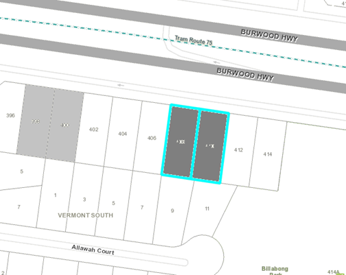
|
|
|
Subject site
|
|
1 Objector Property
|
é
North
|
BACKGROUND
There are
no known planning permits and no relevant history for the subject site.
The
Site and Surrounds
The
subject site is located on the south side of Burwood Highway, approximately 155
metres west from the intersection with Fortescue Grove, and 325 metres east of
the Springvale Road / Burwood Highway intersection. The site, comprising two
lots (408 and 410 Burwood Highway, Vermont South (Lots 3 and 4 of LP 84340) is
rectangular in shape with a northern frontage of 33.52 metres to Burwood
Highway, a maximum depth of 39.01 metres, and a total site area of 1308m².
The site is currently occupied by two single storey dwellings, both setback
13.5 metres from the Burwood Highway frontage. Separate accessways and
crossovers currently serve both dwellings via Burwood Highway. There is a 2.44
metre wide drainage and sewerage easement that runs along the site’s
southern rear boundary.
Adjoining properties
The site
adjoins 5 properties. Both side adjoining properties to the west (No. 406
Burwood Highway) and east (No. 412 Burwood Highway) contain single storey
dwellings, both setback 13.6 metres from Burwood Highway. Both these adjoining
properties also have rear secluded private open spaces that align with the rear
portion of the subject site. Both adjoining properties have received planning
permission for future development, which has yet to commence. Under Permit WH/2016/582,
Nos 412-414 Burwood Highway have planning approval for the construction of a 35
apartment, six storey building, including basement. Under Permit WH/2018/80,
Nos 404-406 Burwood Highway have planning approval for construction of 10
triple storey dwellings.
Adjoining
to the south are the rear private open space areas of Nos 7, 9 and 11 Allawah
Court. These adjoining properties also contain detached single storey
dwellings, with outbuildings within rear yards.
Surrounding Area
There is
an emergence of substantial change along Burwood Highway, with apartment
developments both constructed and approved within the Vermont South, Burwood
Highway streetscape as detailed below:
|
WH/2008/583/B
|
391-399
Burwood Highway, Burwood
|
Staged
construction of a part three, part four and part five storey building with
basement car parking
|
|
WH/2016/623
|
407-409
Burwood Highway, Vermont South
|
Construction
of eight triple storey and one double storey (total nine dwellings)
|
|
WH/2016/582
|
412-414
Burwood Highway, Vermont South
|
Construction
of 35 Apartment, six storey building, and basement car parking
|
|
WH/2016/30
|
431-439
and 441 Burwood Highway, Vermont South
|
Construction
of 35 Apartments, six storey building, and basement car parking
|
|
WH/2015/1090
|
464
Burwood Highway, and 1-3 Charlnet Drive, Vermont South
|
Five
storey (plus basement) residential building
|
Scattered
upper canopy trees amongst an ornamental garden setting is the consistent
landscape character for the surrounding area.
The site is
located within proximity to the following services and facilities:
· Vermont South Shopping Centre (750 metres to north-east)
· Tally Ho Activity Centre (360 metres to west)
· Three primary schools within 900 metres.
· Bus and tram routes (Burwood Highway, adjacent)
· Public reserves (Billabong Park: 30 metres to east,
Charlesworth Park: 560 metres to north-east, and Burwood East Reserve: 820
metres to west).
· Sport Link Vermont (1.1km east)
· Retirement Village (880 metres to east)
· Vermont South Library (870 metres east)
The Titles
of 408 Burwood Highway (Covenant number E365824) and 410 Burwood Highway
(Covenant Number E541893) both contain the same worded restriction that states
the following:
“….administrators
and transferees that they shall not at any time hereafter erect construct or
build or cause to be erected constructed or built on the said land or any part
thereof any house or building not built of brick, stone, concrete or brick
veneer.”
VCAT case
law commonly indicates that legally, this restriction does not isolate the provision
of materials to only brick, brick veneer or stone, but rather that these
materials must be relatively well reflected in the construction of the
building. Also commonly understood in VCAT case law is that this restriction
does not specifically refer to the ‘roofing’, but the
building’s construction only.
The
majority of the construction materials that make up the proposed building are a
mix of concrete blockwork and brick construction to provide consistency with
the covenant’s requirements. A variety of secondary materials are also
provided comprising timber, metal sheet cladding, and metal batten screening,
for external walls. Roofing will comprise steel Colorbond sheeting.
Planning
Controls
In
accordance with Clause 32.07, ‘Residential Growth Zone’ (RGZ1) of
the Whitehorse Planning Scheme, a planning permit is required for the
construction of two or more dwellings on a lot.
Pursuant
to Clause 42.03-2 of the Whitehorse Planning Scheme, a permit is required to
remove, destroy or lop a tree within the minimum front setback in the RGZ1, at
5 metres or greater in height, and with a diameter base height of 1 metre or
greater, measured at 1 metre above ground level. A permit is also required to
construct a building or construct or carry out works within 4 metres of a tree
protected under this Overlay.
PROPOSAL
The
application seeks the removal of the two existing dwellings on the consolidated
site, and proposes buildings and works for the
construction of a 5 storey building (31 dwellings), and associated tree removal
(see Attachments 1 and 2). The key aspects of the
proposal include:
· 31 dwellings arranged on five levels above two levels of
car parking. There will be 5 one bedroom, 23 two bedroom and 3 three bedroom
dwellings, and 34 car spaces within basement and ground floor levels.
· Basement boundary setbacks comprise 2.7 metres (front), and
3 metres (eastern, western and southern boundaries). The ground floor
boundary setbacks consist of 3 metres to 6 metres (front), 3 metres (east
side), 2 metres to 3 metres (west side), and 3.3 metres (rear).
· The first floor boundary setbacks comprise 5.1 metres
(front), and 3 metres (side and rear boundaries). The second floor boundary
setbacks consist of 5.1 metres (front), 3 metres to 4.5 metres (side
boundaries), and 3 metres (rear). The third floor boundary setbacks
comprise 6 metres (front), 4.5 to 6.4 metres (east side boundary), 4.35 metres
to 4.5 metres (west side boundary), and 3 metres to 4.9 metres (rear).
The fourth floor boundary setbacks consist of 7 metres (front), 6.4 metres
(east side boundary), 8 metres (west side boundary) and for the rear boundary,
6.1 metres (balcony) and 9.2 metres (wall).
· A 5.5 metre wide common vehicle accessway will provide
access from Burwood Highway to/from the site along the central portion of this
frontage to service private, commercial and waste vehicles.
The
proposed development will have the following internal floor layouts:
· Basement level 1 (BO1) provides 21 resident car spaces,
residential waste/refuse area, residential external storage areas, a services room,
20,000 litre water tank, lift and stairs core.
· The ground floor level will contain 2 dwellings (dwellings
G.01 and G.02 being one 1 bedroom, and one 3 bedroom dwelling), private open
space areas (court yards), 9 bicycle spaces, centrally located north-south
orientated corridor, mail area, lifts and stairs, 3 ‘services’
boxes both internal and external of the building, 13 car spaces, residential
external storage areas, and waste chutes, and 1.7 metre high front metal slat
fencing.
· The first and second floor levels will contain 9 dwellings
(dwellings 1.01 to 1.09 and 2.01 to 2.09) comprising one 1 bedroom, eight 2
bedroom dwellings per floor, private open space areas (balconies and courtyard
areas), centrally located north-south-orientated corridor, communal lifts and
stairs, light-well and waste chutes.
· The third floor level will contain 7 dwellings (dwellings
3.01 to 3.07) comprising two 1 bedroom, 5 two bedroom dwellings, private open
space areas (balconies), centrally located corridor, communal lifts and stairs.
· The fourth floor level will contain 4 dwellings (dwellings
4.01 to 4.04) comprising two 3 bedroom, 2 bedroom dwellings, private open space
areas (balconies), centrally located corridor, communal lifts and stairs.
· The internal layout, area and bedroom numbers of each
respective dwelling will vary throughout all floor levels, but all generally
include an open plan living/dining/kitchen area, and service rooms. Private
open space areas vary between 12m² and 82m² (ground and first floor
terrace / court areas) and 8m² to 36m² (upper floor balconies).
· The building will have a contemporary design, utilising the
building materials of face brickwork, concrete blockwork, rendered brick,
lightweight sheet cladding, metal perforated and batten screening, metal
cladding, timber-look cladding, battens and glazing.
· The maximum height of the development is 14.9 metres [noting
that building heights are accurately shown on the submitted cross section
plans, whereas the height notations on the elevations plans are what is
perceived from the boundary interfaces]
· The removal of ten (10) trees (some trees are grouped under
one number) on site, 3 trees of which require a permit under the SLO9, as
detailed below:
|
Tree
No.
|
Botanical
Name
|
Common
Name
|
Height
(m)
|
Age
(year)
|
Health/
Structure
|
DBH
(m)
|
|
2
|
Chamaecyparis
lawsoniana
|
Lawsons
Cypress
|
16
|
Mature
|
Moderate
/ Moderate
|
0.27
|
|
3
|
Chamaecyparis
lawsoniana
|
Lawsons
Cypress
|
18
|
Mature
|
Good /
Moderate
|
0.86
|
|
14 (in
part)
|
Chamaecyparis
lawsoniana
|
Lawsons Cypress
|
8
|
Mature
|
Medium /
Moderate
|
0.24
|
· The 7 trees for removal that are not protected under the
SLO9 comprise Trees 4, 5, 14 (in part), 15, 16, 17 and Street Tree 13 for
either being outside the minimum front setback for the RGZ, below 5 metres in
height and/or having a DBH less than 1.0 metre. Council consent is required for
the proposed removal of street tree 13. of Council.
· The proposal seeks to retain three (3) onsite trees (Trees
1, 18 and 14 (in part), and the protection of five (5) adjoining trees (Trees
6, 8, 10, 11 and 12).
CONSULTATION
Public Notice
The application was advertised by
mail to the adjacent and nearby property owners and occupiers and by erecting a
notice at the Burwood Highway frontage. One objection was received
following the advertising period. The objection grounds are summarised as
concerns with parking, traffic, noise, and tree impacts (landscape and habitat
loss).
Consultation
Forum
A
Consultation Forum was not required because only one objection was received.
Without
Prejudice Plans
Following
the advertising period, amended plans were informally submitted as
‘Without Prejudice Plans’ seeking to address issues raised by
Council officer’s and the objector where possible (see Attachment 3).
The key changes as indicated by the applicant include:
General
· Removal of 2 dwellings, one on each of floor levels 3 and 4
(reduced from a total of 31 dwellings to 29 dwellings)
· Reduction in one bedroom dwellings (from 5 to 4 dwellings)
and two bedroom dwellings (from 23 to 22 dwellings).
· Floor layouts for all dwellings on levels 3 and 4 altered
as a result of the deleted dwellings and/or altered boundary setbacks.
· Removal of 1 car space (resulting in total of 33 car
spaces)
Setbacks
· East and west boundary setbacks on levels 3 and 4 generally
increased as follows:
· East Boundary
o Dwelling 3.03
– wall (increased from 6.4 metres to 7.4 metres) and balcony (increased
from 4.5 metres to 4.65 metres).
o Dwelling 3.04
– wall (increased from 5.5 metres to 7 metres) and balcony (increased
from 4.5 metres to 4.65 metres).
o Dwellings 4.02 and
4.03 are now dwellings 4.01 and 4.02 – wall increased from 6.4 metres to
7.4 metres.
· West Boundary
o Dwellings 3.01 and
3.06 – wall (increased from 4.35 metres to 6.05 metres) and balcony
(decreased from 4.35 metres to 4.06 metres)
o Dwelling 3.02
–wall increased from 4.35 metres to 5.12 metres.
o Dwellings 4.01 and
4.03 – wall increased from 8.06 metres to 9.06 metres.
· Rear Boundary
o Dwellings 3.04 and
3.05 – wall (increased from 5.5 metres to 6.5 metres) and balcony
(increased from 3.4 metes to 3.75 metres)
o Dwellings 4.03 and
4.04 are now dwellings 4.02 and 4.03 –, reduced to between 8.15 metres
and 8.48 metres.
Floor layouts
· Other than alterations of dwellings on levels 3 and 4, the
following alterations to dwellings G01 and G02 also apply:
o Dwelling G01
– increase in floor area, car park entry altered and reduction of one car
space (12 car spaces on ground floor level).
o Dwelling G02
– decrease in floor area.
· Although some private open space areas will be reduced
marginally, most upper floor balconies are larger in area varying between
8m² and 57m².
The
without prejudice plans, by their informal nature, were not formally
readvertised, but were circulated to the objector for additional comment. No
additional objection grounds were received. The recommendation contained within
this report is based upon the without prejudice plans.
Referrals
|
VicRoads
|
Notice was given to VicRoads who
provided consent without the inclusion of any required conditions.
|
Internal
|
Asset Engineering (Drainage)
|
The proposed plans have been
reviewed by Council’s Asset Engineer, who supports the proposal subject
to standard drainage and assets conditions.
|
|
Transport Engineer
|
The proposed plans have been
reviewed by Council’s Transport Engineer who consented to the proposed
parking location, parking provision, access traffic generation etc. Support
was also provided for private waste vehicles to carryout bin collection
within the accessway at basement level.
|
|
ESD officer
|
The proposed plans have been
reviewed by Council’s ESD officer, who supports the proposal subject to
standard conditions.
|
|
Waste Officer
|
The proposed plans have been
reviewed by Council’s Waste Engineer, who provided consent.
|
|
Parkswide
|
The proposed plans have been
reviewed by Council’s ParksWide arborist, who supports the removal of
the street tree subject to an amenity contribution to reimburse Council in
accordance with Councils Tree Amenity
Removal Policy.
|
|
Arborist
|
The plans have been referred to
Council’s Arborist who provided consent subject to standard tree
protection conditions.
|
DISCUSSION
In terms
of whether the land is suitable for housing intensification, it is considered
that the site adequately responds to the State Planning Policies being located
within an established residential area on a major road, and having good access
to public transport, services and facilities.
Being also
located within a ‘substantial change’, Residential Growth Zoned
area, the site can be considered an ‘opportunity area’ as defined
by Clause 21.06 - Housing, which provides for increased housing growth and housing
diversity. It is also envisaged that the bulk
of new development will provide a substantial change or shift in building
height, scale and massing within the surrounding public realm as encouraged by
Clause 15.01-2S (Building Design).
In response to Clause 22.03 (Residential Development), the scale of the
proposed development supports a wide range of dwelling types and one, two and three bedroom dwelling layouts to ensure the provision of good dwelling
diversity. Space
for planting has been provided particularly within side and front setback areas
to improve internal amenity and liveability for proposed dwellings.
From the
discussion above, it is considered that the proposed building location and
scale, and provision of dwelling diversity, density and design, generally
comply with the State and Local Planning Policy Framework.
Residential
Growth Zone (RGZ1) and ResCode
The
purpose of the Residential Growth Zone (RGZ1) provides a clear
indication that density and built form will be increased, and that the
departure from the existing character, if the surrounding area is of low scale,
can be considered. However, the development must also provide an appropriate building height, and building
transition between areas of more intensive use (RGZ areas) and other
residential areas, being the Neighbourhood Residential Zoned land (NRZ5) to the
rear of the site. Under this zone, amenity impact in terms of Clause 55.04 in
the areas of overlooking, overshadowing, and visual bulk must be taken into
consideration.
From a
height perspective, the RGZ1 includes preferred maximum height considerations
of 13.5 metres, which can be increased to 14.5 metres if the ground level
measured at any cross section of the site of the building wider than 8 metres,
is greater than 2.5 degrees. In this instance, the first 14 metres into
the site from Burwood Highway, has slopes of greater than 2.5 degrees, with the
balance of the land sloping at approximately 2.36 degrees. The RGZ1 therefore
allows the front portion of the building to have a maximum height of 14.5
metres, while the balance of the building must be reduced to a maximum height
of 13.5 metres. When referring to the cross section plans, the
proposed development comprises 5 stories, at a maximum height of 14.9 metres
(front portion of building), 14.2 metres (central portion of building), and
13.95 metres (rear portion of building) reduced down to 7.6 metres to 8.17
metres (rear building wall to rear adjoining properties).
When
comparing the preferred maximum height limitations of the RGZ1 with the heights
proposed as part of this development, the proposed building will exceed the
14.5 metre height limit by 400mm (height proposed at 14.9 metres), and the 13.5
metre height limit by between 450mm and 700mm (height proposed at between 13.95
metres and 14.2 metres). However, urban context must also be considered and
balanced regarding the appropriateness of building height, and will be
addressed in greater detail below under Clause 58 (Apartment Developments).
To
achieve adequate building transition down to neighbourhood residentially zoned
land adjoining the site’s rear boundary interface, the RGZ demands
compliance with a number of ResCode provisions concerning site layout and
building massing (Standard B10: Energy efficiency), and amenity impacts
(Standard B17: Side and rear boundary setbacks, Standard B18: Walls on
boundaries, Standard B19: Daylight to existing windows, Standard B21:
Overshadowing, and Standard B22: Overlooking). The proposed building will
achieve adequate compliance with the above ResCode provisions as discussed
below:
· Overshadowing will not affect adjoining rear-facing
habitable room windows, and will ensure that at least 75% of adjoining private
open space will receive sufficient northern access through the day as defined
by Standard B21.
· The proposed building mass will be within the Standard B17
envelope, except on the western side elevation with a negligible amount of the
building edges at first, second and third floor levels, and a small portion of
balcony glazing at second and third floor levels, extending outside the
envelope.
· The proposed building will not be situated on any property
boundaries, will have adequate boundary setbacks, and will have upper floors (4th
and 5th floors) stepped in from lower floor levels. The building
will not adversely compromise the solar access to any existing adjoining
windows, and will achieve the intent and provisions of Standards B10 (energy
efficiency), B17 (side and rear setbacks), B18 (walls on boundaries), B19
(daylight to existing windows) and B21 (overshadowing).
· The building form, window and balcony orientation, and
screening measures provided will ensure that all overlooking has been
sufficiently mitigated from all adjoining primary secluded open space areas in
accordance with Standard B22. The proposal has provided setbacks that enable
equitable development with boundary setbacks predominantly being set at, and/or
greater than, 4.5 metres from side adjoining properties. Where the building
projects beyond this distance, windows have raised sill heights of 1.7 metres
above floor level, while either horizontal screens (1.1 metre high) combined
with planter boxes (0.6 metres high resulting in a screening height of
1.7 metres) are provided to balconies (particularly concerning the first and
second floor levels), to address overlooking issues.
As discussed above, compliance
with the above specific Res Code standards indicates that the proposal has
reasonably responded to and achieved adequate building transition down to the
NRZ rear boundary interface, in context to the RGZ1 provisions. However, like
‘height’, the issue of building transition must also be considered
in conjunction with the surrounding urban context, which is discussed in detail
against Clause 58 (Apartment Developments) below. The building height,
scale and massing, when combined with the relevant internal and external
amenity impacts to the site, must also be applied within the surrounding urban
context to which the site is located. This will now be discussed below.
Clause
58 – Apartment Developments
The scale
and massing, design and layout of the proposed development will achieve
acceptable compliance with Clause 58. The key issues can be summarised now.
Urban
Context and Site Layout
Immediately
Surrounding Public Realm
The scale
and massing of the proposed apartment building will carry a high profile to the
Burwood Highway road corridor, largely given the width and open character of
the road corridor (which includes additional space from service lanes), the
consolidated two-parcel-width of the development site, and absence of large
canopy trees along the road corridor.
The proposal will also comprise of
one solid building mass across the site, with no voids through the centre of
the site to visually break the building into multiple forms or provide
view-lines across the site. However, the boundary setbacks of the proposed
development will be relatively consistent with the approved development on both
side adjoining properties (404-406 Burwood Highway and 412-414 Burwood Highway).
From a ground floor footprint perspective, the following comparison is made:
|
Property
|
Minimum
Front Setback
|
Minimum
Side Setbacks
|
Minimum
Rear Setbacks
|
|
Subject
Site
|
6.1
metres
|
3
metres
|
3.75
metres
|
|
404-406
Burwood Highway
|
6
metres
|
3.5
metres
|
3.5
metres
|
|
412-414
Burwood Highway
|
5
metres
|
3
metres
|
3
metres
|
It is
considered that there is sufficient spacing around the proposed building to
provide views across the site to landscape backdrops, creating an
adequate sense of spacing and separation between buildings on and
adjacent the site.
As
indicated by the submitted plans, the proposed building will project forward of
both existing detached dwellings adjoining the site on both sides boundaries.
However, the proposed development will match the front boundary setbacks of
both side adjoining approved developments. This will ensure that the proposed
building will be sympathetic with the future prevailing street setback.
The
massing of the building will comprise a 28 metre wide, 3 storey high podium or
street wall that steps in from the lower floor levels by 7.5 metres (20.5 metre
width) for the fourth storey, and then a further 3 metres (17.2 metre width)
for the fifth storey. The top two levels will be recessive to the lower floor
levels to alleviate boxy built form. Along with reduced floor-to-ceiling
heights, pitched roofing and a high level of urban design detail, there will be
strong visual interest to the contemporary building appearance.
Due to
the fall of the land from west to east, there will be a noticeable drop down to
the frontage for the initial 14 metres into the site, the proposed
building’s 5 storey appearance is exposed primarily to the northern front
elevation and partially to the east side elevation. The ground floor is
otherwise predominantly cut into the land to the west and rear portions of the
site, presenting as an articulated 4 storey appearance to the western boundary,
and with a 2 to 2.5 storey appearance to the rear boundary interface given the
extensive stepping in of upper levels from lower floor levels and cross-slope
from east to west.
Additionally,
the basement, being setback 4.37 metres from the front boundary, and 3 metres
from all side and rear setbacks, will provide deep soil planting of moderate
width to accommodate medium to tall trees (4-8 metres high). This will ensure
the provision of a strong landscape screen along the side and rear boundaries
to reduce building massing to the mentioned boundary interfaces.
It is
acknowledged that the 2.44 metre wide easement along the rear boundary, as an
encumbered space, will prevent the replanting of new canopy trees in the rear
setback area. The proposal addresses this constraint by retaining Tree 18 and
protecting established canopy trees 6, 8 and 10 (screen height varying between
8 metres and 14 metres) along the rear boundary. Additionally, portions of the
existing Lawson’s Cypress landscape screen (Trees 1 and 14 (in part) with
a height varying from 8 metres to 17 metres) along the front boundary
will be retained, along with the retention of Trees 1 and 14 (in part) to
partially retain an element of the site’s landscape setting to the street
and the wider landscape. The landscape plan has also indicated the provision of
2 canopy trees per respective side and front boundary setback area.
From this
perspective, the overall landscape screen will be effective in alleviating the
bulkiest elements of the proposed building’s mass to all boundary
interfaces.
Given the
above considerations, from an immediate public realm perspective, reasonable
measures have been implemented to address building mass, scale and height,
comprising recessive upper floors, high grade urban design, good boundary
setbacks, moderate deep soil planting areas for good landscape opportunities,
canopy and screening tree retention. However, Standard D1 (Urban Context) takes
into account a much wider scope of the surrounding area when considering urban
context within the public realm. This will now be discussed.
Wider
Urban Context – Apartment Developments approved and/or constructed
Standard D1 of Clause 58.02-1 (Urban
Context) requires consideration that the ‘design responds to the
existing urban context or contributes to the preferred future development of
the area’. This translates to whether similar apartment buildings
have been approved and/or constructed in the area, providing support for the
proposed apartment building within a surrounding urban context. A review of
Council’s planning records and the Burwood Highway within Vermont South
has confirmed the following examples approved and / or constructed:
|
Constructed
|
|
Address
|
Development
|
|
464
Burwood Highway, Vermont South
(WH/2015/1090)
|
5
storey (16.1 metre high) apartment building.
|
|
Approved, not constructed
|
|
391-399
Burwood Highway, Vermont South (WH/2008/583/B)
|
6
storey (15.9 metre height) apartment building.
|
|
407-409
Burwood Highway, Vermont South (WH/2016/623)
|
3
storey (9.35 metre height) terrace dwelling development.
|
|
431-441
Burwood Highway, Burwood East (WH/2016/30)
|
5
storey (18 metre high) apartment building.
|
|
412-414
Burwood Highway, Vermont South (WH/2016/582)
|
6
storey (17.1 metre high) apartment building
|
|
404-406
Burwood Highway, Vermont South (WH/2018/80)
|
3
storey terrace dwelling development (9.25 metres)
|
As
detailed above, only 1 of the 6 examples has been constructed, being the 5
storey apartment building at 464 Burwood Highway, Vermont South (see
Attachment 4). This building sets the tone within the public realm that a
substantial shift in building scale, and dwelling diversity and density is
emerging within the Burwood Highway, RGZ substantial change area in Vermont
South. Whilst it is acknowledged that construction generally has not commenced
for most approved apartment developments mentioned above, these do confirm the
likely occurrence of an ongoing rate of substantial change in the years to
come. This means that these examples of apartment development should be taken
into consideration, as they will likely form part of the future public
interface.
When
comparing the 5 storey apartment building at 464 Burwood Highway with the
proposed development, this constructed building is generally similar in width,
scale, setbacks, but is greater in height at 16.1 metres. This nearby building
provides a less articulated building form to the proposed development
particularly at upper floor levels, and will have a more dominant appearance to
the Burwood Highway road corridor.
Although
not constructed, the most relevant apartment building approved in close
proximity is 412-414 Burwood Highway which adjoins this site to the east. This
building is greater in height (17.1 metres), and has a 6 storey appearance to
Burwood Highway at the point of the front basement entry. This adjoining
approved building will provide similar boundary setbacks to the proposed
development. At 17.1 metres in height, this building did not achieve compliance
with the RGZ preferred height limits, and will be 2 metres taller than the
proposed apartment building. It is also noted that this was a VCAT decision,
with officers seeking outcomes reflecting reduced building heights, comparable
to those being contemplated for the subject site.
This
adjoining approved building is a less articulated building form than the
proposed development, and the building form will present as a 4 to 5 storey
building to all residential boundary interfaces, and as a 6 storey building to
Burwood Highway. With little visual relief to upper floors and flat roofing,
this building will present as a more dominant, boxy building mass to the
proposed building. The added height and 4 to 6 storey appearance to building
interfaces will also likely result in that building presenting in a more
visually dominant manner, than the proposed building. Whilst this in itself is
not reason enough to approve the proposed building, it does provide insight as
to shifting expectations for how buildings respond to major road corridors.
Overall
it is evident that the surrounding urban context supports 3 storey town house /
terrace style dwelling development; existing development has adopted this
approach in response to the RGZ building height limitations and transition to
neighbouring lower scale zones. It also supports 4 to 6 storey apartment
development that is at the upper limits of height expectations, or indeed
exceeds it. This reflects a less integrated height and building transition
within the RGZ1.
By
contrast, the proposed apartment development is similar or smaller in height,
scale, and massing to the apartment developments already approved, with
boundary setbacks being similar or greater by relative comparison. The proposed
development has sought to find a middle ground response between what the
current predominant building form reflects, and what is anticipated as the
emerging character.
The
emergence of this higher building form has been identified through strategic
work being undertaken by Council, and as such raises the question; does this
align with the expectations of Council?
Residential
Corridor Strategy Built Form Guidelines ‘Corridor Strategy (as adopted)
The site is located within
‘Study Area 4 of the ‘Residential Corridor Built Form Study’.
Adopted in January 2019, the Corridor Strategy is a background document that
contains design guidelines focused on approved apartment development along the
Whitehorse Road and Burwood Highway transport road corridors. The aim of this document is to supplement existing substantial change
objectives in the planning scheme (including the RGZ) by providing additional
contextual measures that modify preferred maximum building height of the RGZ
depending on which lower order residential zone the relative RGZ land
interfaces with. Further, the Guidelines provide prescriptive boundary setbacks
for the first 4 stories, with more restrictive prescribed boundary setbacks for
any floor above four stories. These measures are included to achieve
appropriate building transition outcomes.
Although this document has no status
in the Planning Scheme, it has importance as
it attempts to ‘bridge the gap’ in aligning the expectations of
Council with both the purpose of the RGZ1, and the existing and approved
apartment development in the surrounding public realm, from a character,
building height and transition, equity and external amenity perspective. This
will now be discussed in greater detail.
Height
The
subject site would be located within ‘Study Area 4’ which affects
suburbs west of Springvale Road (Burwood and Burwood East), and east of
Springvale Road (Vermont South). The section of the study area west of Springvale Road is flanked by ‘Natural
Change’, General Residential Zone areas. The preferred maximum building
height expectations for this area are greater than those set in the RGZ,
identifying between 5 stories (16 metres) and 6 stories (19 metres) in height
depending on whether land parcels can be consolidated into larger properties.
Relative
to the site, the section of Study Area 4 east of Springvale Road in Vermont
South is flanked by ‘Limited Change’, Neighbourhood Residential
area. Being a lower density, traditional residential area, the preferred
maximum building height is lowered below the RGZ expectations at 13 metres.
Unlike the RGZ, land slope does not influence preferred maximum building height
under the Corridor Strategy. From this
perspective, the proposed development would
exceed the 13 metre height limitations by up to 2 metres at various sections
across the site and will not achieve compliance in this regard.
Building
Transition
The
corridor strategy also includes measures to address building transition between
RGZ land and the lower order NRZ or GRZ residential zoned land abutting RGZ
land. The aim is to essentially alleviate visual impact of taller buildings
through increased upper floor setbacks, creating a sense of openness and
expansive sky views along the relevant road corridor. Specifically, the
Corridor Study outcomes limit front setbacks (ground floor: 5 metres, extended
by an additional 3 metres for the fourth storey and above), side setbacks (4.5
metres, extended to 9 metres for the fourth storey and above) and rear setbacks
(9 metres).
From this
perspective, the proposed development will have front setbacks between 5.1
metres and 6.1 metres for the first 3 stories, 8.35 metres (balconies reduced
to 6.1 metres) for the fourth storey and 9.5 metres (balconies reduced to 7.03
metres) for the fifth storey. The side setbacks will be 3 metres (first 3
stories), between 5.12 metres and 7.1 metres (fourth storey) and between 7.4
metres and 9 metres (fifth storey), which will achieve general compliance with
the corridor strategy guidelines. Rear boundary setbacks will vary between 3
metres and 6.5 metres (first three stories), and up to 8.6 metres for the 2
upper floors. While the proposal will not achieve full compliance with the
Corridor design guidelines, the margin of non-compliance is not considered to
be significant.
Weighting
of Policies / Strategic Documents
In
summary, when comparing the preferred maximum building height and transition
provisions of the RGZ with the examples of approved and constructed apartment
development within urban public realm context, the proposed apartment building
is more closely aligned with the expectations of the RGZ, and more sensitive to
boundary interfaces as encouraged by the Corridor Strategy, than the
surrounding examples, reflecting a more appropriate built form and massing
outcome and, transition to NRZ properties.
It is
also considered that building height requirements of the RGZ can be satisfied
via conditions of approval through modifications to the extent of earthworks, floor
width and ceiling height. This, when combined with the extent of vegetation
being retained and planted across the site as part of the landscape plan, will
ensure that the intent and provision of Clause 58.02 (Urban Context) and
Standard D1 can be adequately satisfied.
Environmental Sustainability Development
From an
environmental sustainability design and energy efficiency perspective, the
proposal has provided general compliance with dwelling, balcony and general
internal floor layout concerning windows
(Standard D26), natural ventilation (Standard D27), room depth (Standard D25),
integrated water and stormwater management (Standard D13) , and energy
efficiency objective (Standard D6), concerning the submitted plans.
The Sustainability Management Plan, as well as the BESS, STORM
and Preliminary NatHERS reports, all include scores
that indicate a 6 star average and 5.5 star minimum throughout the proposed development. This will achieve
compliance against Clause 22.10 (Environment Sustainability Development),
subject to conditions of approval addressing the outstanding minor issues
primarily concerning effective management of grey water overflow emanating from
the site.
Site services
All
service boxes are provided on ground level externally (front setback area), or
internal at ground floor level. Subject to conditions of approval, all
locations can be sufficiently concealed, or their visual impact to the
streetscape minimised. The site and proposed building will have the capacity to
connect to all utility services in accordance with Standard D4
(Infrastructure).
Functional
Layout
All
bedrooms, living areas, room depth, daylight access to all windows and
ventilation of all bedrooms are compliant in their dimensions. Accessibility
throughout the floor layout of all dwelling modules will also be compliant with
table D4 and Standard D17 ‘Accessibility’ of Clause 58.05-1. Dwellings 1.01, 1.05, 2.01 and 2.05, however
have side-facing ‘snorkel’ window depths exceeding 1.5 metres,
which will allow for limited adequate daylight access into the adjacent
habitable rooms. This issue can be addressed as a condition of approval in
appropriately reducing snorkel depth to achieve compliance with the Standard
D26 (Windows). The building design does have capacity to achieve improved
window layouts.
Building
entries will generally have their own identity and will foster safe, functional
and efficient movement to and from the lifts on each level to achieve
compliance with Standards D9 and D18 (Building Entry and Circulation).The
exception is dwelling G01 that is provided with no dedicated front entry. This
issue can be addressed as a condition of approval requiring a dedicated font
entry foyer, and pathway separate from the private open space area to meet both
Standards.
Subject
to conditions of approval, private open space areas for all dwellings will
comply in width and area in accordance with Standard D19 (Private Open Space)
of Clause 58.05-3.
Concerning
communal spaces, corridors are limited in width at 1.6 metres. This is
acceptable as they are not long sections and expand up to 3.8 metres in width
where adjacent to lifts and stairs to accommodate efficient movement, and
queuing adjacent the lifts. The corridors incorporate a number of corners, and
at times wrapping around a light well, which introduces visibility and safety
improvements for occupants wanting to return to, or leave from, their
dwellings. It is further acknowledged that while corridors do not have direct
access to an external wall to take advantage of natural ventilation and
daylight, the multi-storey central light well and ventilation duct to the rear
of the lift, is an adequate response.
The
proposed apartment building will also provide sufficient external storage space
for all dwellings fully or in part within the respective dwelling layout and/or
the basement areas. This will satisfy Standard D20 (Storage) of Clause 58.05-4.
External
Amenity Impacts
With
boundary setbacks varying from 3 metres and 9 metres, the proposed building
will be sufficiently setback such that any overshadowing created, will not have
an adverse detriment on the amenity of any adjoining residential property. A
level of overshadowing will occur to side and rear adjoining properties.
However, the extent and duration of overshadow over adjoining primary secluded
private open space court areas, within the hours of 9am to 3pm as required by
Standard B21 (Overshadowing Open Space), will be of limited impact.
Overshadowing impacts to habitable room windows are less than 1 hour and thus,
is an acceptable design response.
All POS
balconies will employ a variety of internal screening devices, differing
orientations and locations, to protect internal views into other proposed POS
areas and habitable room windows. This will sufficiently address Standard D15
(Internal Views) of Clause 58.
It is
considered that the colour, materials and finishes palette is acceptable and
will provide a contemporary appearance to the proposed building. The exception
to this is the brighter yellow colour applied to the eastern corner of the
building. This needs to be altered to provide a more muted tone reflected in
surrounding development, and can be addressed as a condition of approval.
Car
parking is enclosed at ground floor level (partially cut into the natural
ground level through the central and rear portions of the site) and contained
within a basement floor level. This will ensure that all potential noise
sources to external boundary interfaces will be mitigated. Internally however,
the rear entry to dwelling G01 is directly from the basement, potentially being
exposed to the main noise source of the site. This issue can however be
addressed as a condition of approval ensuring that the rear entry door and
eastern wall of this dwelling implement noise attenuation measures. This will
address the provisions of Standard D16 (Noise Impacts).
Additionally,
while all corridors generally have direct access to a building wall to gain
access to natural daylight and ventilation, the rear access to dwelling G01
will be directly from the basement. There is a concern that vehicle fumes may
impact the enclosed habitable floor space of this dwelling. This issue can
however be addressed via a condition of approval ensuring appropriate
ventilation in accordance with Standard D27 (Natural Ventilation).
Significant
Landscape Overlay (SLO9) / Landscaping (Standard D10)
Due to
the proximity of proposed basement, excavation and driveway works, Trees 2, 3,
and 14 (in part) protected under the SLO9, will require removal within the
front setback area. These trees do not have wide canopies that contribute to
the wider landscape, but rather, play a more localised role internal to the
site and landscape screening role external to the site.
An
objection ground focused on the retention of vegetation on site to ensure that
the wider landscape character will be protected and enhanced, and that the
habitat of fauna can be maintained.
Council
Officers raised concerns regarding this issue, seeking to retain as much of the
existing vegetation as possible within both front and rear setback areas. This
would enable an immediate landscape screen to visually alleviate building mass
to both the streetscape and rear yard interface of properties adjoining the
site to the rear. This was particularly relevant as the setbacks proposed do
not allow for the replanting of tall canopy trees within easements along the
rear boundary.
The
applicant responded by increasing the front setback and the deep soil planting
area to retain Tree 1 and the western part of Tree 14 (existing cypress screen)
along the front boundary, while seeking to retain Trees 8 (Cherry Plum) and 18
(Norway Spruce), which currently provide a partial landscape screen to rear
adjoining properties, through their varying heights of 8 metres to 10 metres.
Additionally, Council’s consulting arborist has confirmed that all
adjoining trees can be retained and that their retention would support the
existing landscape screening.
The site
does not contain any significant established canopy trees that contribute to
the wider landscape. However, the proposal does offer an acceptable level of
retention of onsite vegetation, as well as including sufficient deep soil
planting areas in boundary setback areas. This will provide a landscape theme
that will be effective in partially screening the lower levels to all boundary
interfaces, the bulkiest element of the proposed development.
With a
total site area of 1,308m², the proposal will provide more than 7.5% of deep soil
planting at minimum widths of 3 metres, as well as medium sized trees at a
density greater than 1:50m2 of area in accordance with table D2 of
Standard D10 (Landscaping) of Clause 58.03. This will provide sufficient
landscape opportunity for replacement planting. Constraints such as easement
encumbered land along the rear boundary, can be addressed with the retention
and protection of a number of the trees at the front and along boundaries of
the site. This accords with the objectives of Clause 22.04 (Tree Conservation)
and the SLO9.
A key
objection ground focused on tree loss from a landscape and habitat loss
perspective. The above discussion indicates that a suitable provision of
existing trees are being retained and proposed canopy trees planted. This will
ensure that an acceptable landscape setting is provided to the adjacent Burwood
Highway road corridor, while providing a greater provision of canopy species to
strengthen, not lessen, the potential habitat capacity of the site for local
fauna. This addresses this objection ground.
Clause 52.06 (Car Parking and Access) / Standard D11 and 12
of Clause 58.03 / Waste Management / Noise
Required Car spaces
Clause 52.06 requires 1 car space for each 1 to 2 bedroom
dwelling, 2 car spaces for dwellings with 3 or more bedrooms, and 1 visitor car
space for every 5 dwellings proposed. Also applicable is the site’s
location within the Principal Public Transport Network Area, which removes the
visitor parking requirement under Clause 52.06. Based on these parking
rates, the following calculations on the proposal are provided:
|
Usage
|
Required Spaces
|
Spaces Proposed
|
|
Dwellings
|
|
|
|
· Four 1 bedroom dwellings
|
4
|
4
|
|
· Twenty-two 2 bedroom dwellings
|
22
|
23
|
|
· Three 3 bedroom dwellings
|
6
|
6
|
|
· Visitor parking
|
0
|
0
|
|
Total
|
32
|
33
|
Required bicycle spaces
|
Usage
|
Number
|
Employee Rate
|
Visitor Rate
|
Required
Spaces
|
Provided Spaces
|
|
Dwellings
|
42
|
1 space
per 5 dwellings
|
1 space
per 10 dwellings
|
5
resident
2
visitor
|
|
|
|
|
Total
spaces required
|
7
|
9
|
A key
objection ground focused on increased traffic, limited on-site parking capacity
and noise as a result of the development. As detailed above, the
development provides sufficient on-site car parking meeting the requirements of
Clause 52.06 and as such will not cause any unreasonable traffic impact to
Burwood Highway or any other nearby street within the surrounding road network.
As shown
above, the number of bicycle spaces and design of the bike spaces are
satisfactory with 9 bike racks at ground floor level, which will meet Clause
52.34. Council’s Transport Engineering officer has consented to the
proposed development on access and parking provision and location, except the
access arrangements for private waste vehicles, which can be addressed as a
condition of approval. Council’s Waste officer has nevertheless consented
to the waste management arrangements in this regard.
Objections
Parking – This issue has been
addressed under the ‘External Amenity Impacts’ section earlier in
this report.
Traffic – This issue has been
addressed under the ‘External Amenity Impacts’ section earlier in
this report.
Noise – This issue has been
addressed under the ‘External Amenity Impacts’ section earlier in
this report.
Vegetation Loss – This has
been addressed under the SLO9 / Landscape earlier in this report.
CONCLUSION
The
proposed development is consistent with the relevant planning controls and
policies, including the State and Local Planning Policies and provisions of the
Residential Growth Zone Schedule 1. The scale, height,
width, siting, form and appearance of the proposed development, and retention
of landscape trees and landscape opportunities to provide for the replanting of
numerous medium sized trees, is consistent with the substantial change policies
contained within the State and Planning Policy Framework, as well as meeting
the expectations of the RGZ subject to conditions of approval.
The
proposal will be consistent with the existing and preferred pattern of
development and neighbourhood character, and will not cause adverse amenity
impacts to the adjoining properties, the adjacent streetscape and surrounding
public realm.
The
application has been advertised and 1 objection has been received. The
issues have been discussed above.
As the
proposed development is appropriate in form and appearance, approval is
recommended.
Attachment
1 Advertised
Development Plans ⇨ 
2 Advertised
Landscape Plans ⇨ 
3 Without
Prejudice Plans ⇨
4 Substantial
Change Apartment Examples ⇨ 
Ordinary Council Minutes 16
September 2019
9.1.2 2
Sergeant Street, Blackburn (Lot 11 LP 6826) Construction of a four storey
apartment building, buildings and works within 4 metres of protected trees
(SLO9).
FILE NUMBER: WH/2018/619
ATTACHMENT
SUMMARY
This application was advertised,
and a total of eight (8) objections were received, at the end of the
advertising period. A Consultation Forum was conducted on 23rd
April 2019, chaired by Councillor Massoud. At the meeting, issues were
explored, however no resolution was reached between the parties. An
additional fourteen (14) objections were received after the Consultation Forum,
resulting in a total of twenty two (22) objections being received. The
objections raised issues including overdevelopment, amenity impacts, traffic
and parking, loss of vegetation and habitat, and deficiencies in landscaping.
Council was notified on the 29th
of August, 2019 that the applicant had lodged an application for review to the
Victorian Civil and Administrative Tribunal (VCAT) against Council’s
failure to determine the application within the prescribed statutory timeframe.
The purpose of this report is to
provide Council’s assessment of the application against the relevant
provisions of the Whitehorse Planning Scheme, as well as the objector concerns,
and recommends approval of the application, subject to modification to be
addressed by way of permit conditions.
|
RECOMMENDATION
That Council:
A. Being the Responsible Authority,
having caused Application WH/2018/619 for 2 Sergeant Street, BLACKBURN (LOT
11 LP 6826) to be advertised and having received and noted the objections is
of the opinion that the granting of a Planning Permit for the construction
of a four storey apartment building, and buildings and works within 4 metres
of protected trees (SLO9) is acceptable and
should not unreasonably impact the amenity of adjacent properties.
B. Has formed a position to support
the application in relation to the land described as 2 Sergeant Street,
BLACKBURN (LOT 11 LP 6826) for the construction of a
four storey apartment building, and buildings and works within 4 metres of
protected trees (SLO9), and notification of
this position be given to VCAT, subject to the following conditions:
1. Before
the development starts, or vegetation is removed, amended plans shall be
submitted to and approved by the Responsible Authority in a digital
format. When approved, the plans will be endorsed and will then form
part of the permit. The plans must be drawn to scale, with dimensions,
and be generally in accordance with the plans submitted with the application
but modified to show:
a) The
north facing balcony areas, associated with Dwellings 102, 103 and 104 at the
first floor level setback a minimum of 3.5 metres from the northern boundary.
b) The
north facing balcony areas, associated with Dwellings 202, 203 and 204 at second
floor level setback a minimum of 3.5 metres from the northern boundary.
c) The
south facing balcony areas, associated with Dwellings 105, 106 and 107 at
first floor area setback a minimum of 4.5 metres from the southern boundary.
d) The
south facing balcony areas, associated with Dwellings 205, 206 and 207 at
first floor area setback a minimum of 4.5 metres from the southern boundary.
e) All
habitable room/area(s) with dual aspect, must be provide with a minimum of
two (2) openable windows, to provide further cross ventilation for each of
the respective room/area.
f) All
habitable room windows must satisfy the requirement of Standard B22.
g) The
private open space (balcony) size and width must achieve:
i. Eight
(8) square metres, with minimum width of 2 metres, for all two bedroom
dwellings.
ii. Twelve
(12) square metres, with a minimum width of 2.4 metres, for all three bedroom
dwellings.
iii. Compliance
with the objective of Standard B43, Clause 55 (private open space above
ground floor),
h) Cross
section shadow diagrams, showing shadow movements for every hour between 10am
to 3pm, demonstrating the north habitable room windows at 4 Sergeant Street,
not detrimentally affected by overshadowing.
i) Protruding
nib walls between abutting balconies for privacy protection.
j) Detail
of proposed materials/presentation of all windows and balcony screens.
k) Roof plan illustrating all plant and equipment to be screened from
all street interfaces.
l) Submission
of colour photographs of cladding finishes demonstrating variation to the
cladding finishes whereby the dark/grey themed material palette to
incorporate warmer colour tones and/or materials. This could include
(but not limited to) alternative screen colours and warmer timber look
materials upon the under-side of balconies.
m) Amendments
in accordance with Council’s Transport Engineer recommendations as
follows:
i. The
two southern tandem parking spaces, adjacent to the northern wall of the
entry ramp be deleted and substituted by two double stackers to be
accommodated within the basement area.
ii. Any
subsequent increase to the internal floor and ceiling height of the basement
area, resulting from modification under condition h(i), must not alter the
finished floor level and building height at the ground level and the overall
building height.
iii. A
passing area to be located within the basement area at the bottom end of the
basement entry ramp, and must have a minimum dimension of 6m length and 6.1m
wide.
iv. The
location of columns within the car park are to be designed in accordance with
Clause 52.06-8 of the Whitehorse Planning Scheme.
v. Any
proposed car stacker make and model are required to be nominated on the
proposed layout plans. The car stacker spaces are required to accommodate a
1.8 metres vehicle (i.e 2 metres of clear headroom) in ground level stacker
spaces.
vi. The
proposed pits for any proposed car stackers must have an internal clear
length of 5.4 metres so that the vehicle can park in the stacker.
vii. The
proposed ramp grades to demonstrate the design requirements of AS 2890.2.
viii. The
available sight distance at access driveways in accordance with Clause 52.06
of the Whitehorse Planning Scheme.
n) A
Car Parking Management Plan, in accordance with Condition 5 and the basement
plan must be amended to show allocation of parking spaces as follows:
i. Each
pair of tandem parking spaces must be allocated to a 3 bedroom dwelling, with
the remaining spaces to be designated to the remaining dwellings.
ii. Detail
any access controls to the parking area, such as boom gates which shall take
into the required queue length required as par section 3.4 of AS 2890.1.
iii. All
other requirements of Parking Management Plan in Condition 5.
o) All
modification to plans in accordance with Condition 18, Sustainable Management
Plan (SMP) including:
i. All operable windows, doors and vents in elevation drawings.
ii. Exterior shading for all east, north and west windows greater than
1.5 square metres, to shade at least 30% from 11am to 3pm on 1 February or
otherwise provide renewable (photovoltaic) technology.
iii. Include glazing specifications for all residential glazing,
including solar heat gain coefficient (SHGC), visual light transmittance
(VLT) and U-value.
iv. Location of clotheslines.
v. Any exterior building services equipment, including any heating,
cooling, ventilation, hot water systems, as well as, electric vehicle (EV)
charging facilities.
vi. Where measures cannot be visually shown, include a notes table
providing details of the requirements (i.e. energy and water efficiency
ratings for heating/cooling systems and plumbing fittings and fixtures,
etc.).
p) Landscape
Plan in accordance with Condition 3, including the following:
i. A revised landscaping scheme, within the easement area, western
boundary, with appropriate species of tree/shrubs capable of providing dense
screen planting along this interface.
ii. All canopy trees are to be a minimum 2.0 metres in height at the
time of planting.
iii. Review of canopy tree planting species.
iv. Notation(s) on landscape and development plans stating “no
alteration to existing ground surface levels, within the northern
setback”, in lieu of the existing notation, relating to
‘maintaining existing grades’.
q) The
location of the Structural Root Zone and Tree Protection Zone for Tree 1
(street tree) described in Condition 4, with the nominated tree clearly
identified and numbered on the site plans and the requirements of conditions
4 and 5 to be annotated on the development and landscape plans.
r) An amended Sustainability Management Plan (SMP), in accordance
with Condition 18.
s) An amended Waste Management Plan (WMP) in accordance with
Condition 19.
All of the above must be
to the satisfaction of the Responsible Authority. Once approved these plans
become the endorsed plans of this permit.
2. The
layout of the site and the size, design and location of the buildings and
works permitted must always accord with the endorsed plan and must not be
altered or modified without the further written consent of the Responsible
Authority.
3. No
building or works shall be commenced (and no trees or vegetation shall be
removed) until a landscape plan prepared by a suitably qualified and
experienced person or firm has been submitted to and endorsed by the
Responsible Authority. This plan when endorsed shall form part of this
permit. This plan shall show -
a) A
survey of all existing vegetation, abutting street trees, natural features
and vegetation.
b) Buildings,
outbuildings and trees in neighbouring lots that would affect the landscape
design.
c) Planting
within the easement area, along the southern boundary of the site comprising
trees and shrubs capable of:
d) Providing
a complete garden scheme,
e) softening
the building bulk along the southern elevation,
f) A
schedule of the botanical name of all trees and shrubs proposed to be
retained and those to be removed incorporating any relevant requirements of
condition No. 1.
g) The
proposed design features such as paths, paving, lawn and mulch.
h) A
planting schedule of all proposed vegetation (trees, shrubs and ground
covers) which includes, botanical names, common names, pot size, mature size
and total quantities of each plant.
i) Landscaping
in accordance with this approved plan and schedule must be completed before
the building is occupied.
Once approved these
plans become the endorsed plans of this permit.
Tree Protection
4. Prior
to commencement of any building or demolition works on the land, Tree
Protection Zones (TPZ) must be established on the subject site and within the
nature strip and maintained during, and until completion of, all buildings
and works including landscaping, around the following trees in accordance
with the distances and measures specified below, to the satisfaction of the
Responsible Authority:
a) Tree
Protection Zone distances:
i. Tree 1
– 7.1 metre radius from the centre of the tree base.
ii. Tree 2
– 2.2 metre radius from the centre of the tree base.
iii. Tree 3 – 2.0
metre radius from the centre of the tree base.
iv. Tree 4
– 4.3 metre radius from the centre of the tree base.
v. Tree 5
– 2.4 metre radius from the centre of the tree base.
vi. Tree 6
– 3.0 metre radius from the centre of the tree base.
vii. Tree 7 – 2.0
metre radius from the centre of the tree base.
viii. Tree 8 – 2.0
metre radius from the centre of the tree base.
ix. Tree 13
– 3.6 metre radius from the centre of the tree base.
x. Tree 14
– 3.0 metre radius from the centre of the tree base.
xi. Tree 15
– 2.0 metre radius from the centre of the tree base.
xii. Tree 16 –
2.0 metre radius from the centre of the tree base.
b) Tree
protection zone measures are to be established in accordance to Australian
Standard 4970-2009 and including the following:
i. Erection
of solid chain mesh or similar type fencing at a minimum height of 1.8 metres
held in place with concrete feet.
ii. Signage
placed around the outer edge of perimeter fencing identifying the area as a
TPZ. The signage should be visible from within the development, with the
lettering complying with AS 1319.
iii. Mulch
across the surface of the TPZ to a depth of 100mm and undertake supplementary
watering in summer months as required.
iv. No
excavation, constructions works or activities, grade changes, surface
treatments or storage of materials of any kind are permitted within the TPZ
unless otherwise approved within this permit or further approved in writing
by the Responsible Authority.
v. All
supports, and bracing should be outside the TPZ and any excavation for
supports or bracing should avoid damaging roots where possible.
vi. No
trenching is allowed within the TPZ for the installation of utility services
unless tree sensitive installation methods such as boring have been approved
by the Responsible Authority.
vii. Where
construction is approved within the TPZ, fencing and mulching should be
placed at the outer point of the construction area.
viii. Where
there are approved works within the TPZ, it may only be reduced to the
required amount by an authorised person only during approved construction within
the TPZ and must be restored in accordance with the above requirements at all
other times.
c) During
construction of any buildings, or during other works, the following tree
protection requirements are to be adhered to, to the satisfaction of the Responsible
Authority:
i. A
project arborist must be appointed by the applicant or builder and must
supervise all approved works within or in the vicinity of the TPZs of Tree
numbers 1, 2, 3, 4, 5, 6, 7, 8, 9, 10, 11, 12, 13, 14, 15 and 16. The project
Arborist must ensure that any buildings and works (which includes excavation
works) do not adversely impact the health or stability of the tree(s) now or
into the future.
ii. Applicant
to confirm in writing to the Responsible Authority the contracted arborist to
be on site to supervise protection of trees, prior to commencement of
buildings and works.
iii. For
Trees numbers 1, 2, 3, 4, 5, 6, 7, 8, 9, 10, 11, 12, 13, 14, 15 and 16 no
roots greater than 40mm in diameter are to be cut or damaged during any
part of the construction process.
iv. All
buildings and works for the demolition of the site and excavation and
construction of the basement car park and building (as shown on the endorsed
plans) must not alter the existing ground level or topography of the land
within greater than 10% of the TPZs of Tree numbers 1, 2, 3, 4, 5, 6, 7, 8,
9, 10, 11, 12, 13, 14, 15 and 16.
v. The
project arborist and builder must ensure that TPZ Fencing Conditions are
being adhered to throughout the entire building process, including site
demolition, levelling and landscape works.
vi. Any
excavation within the TPZ of the street tree must be undertaken by hand,
hydro excavation or air spading to ensure adequate protection of the trees
root network.
Parking Management
Plan
5. Prior
to the commencement of any demolition, buildings or works on the land, a
Parking Management Plan must be prepared to the satisfaction of the
Responsible Authority, detailing:
a) The
designated parking spaces to the individual dwellings.
b) Pedestrian
access and movement within the car parking areas, including strategies to
minimise the potential for conflict between pedestrians and vehicles.
This may include line marking such as hatched shared areas, directions signs
and/or physical barriers.
c) Location
of bicycle parking signs in accordance with Clause 52.34-5.
d) Line
marking of parking spaces.
e) Detail
how access to the proposed parking spaces will be secured for residential and
use; and
f) Detail
any access controls to the parking area, such as boom gates which shall take
into account the required queue length required as per section 3.4 of AS
2890.1.
g) Details
of how access to the waste collection areas will be achieved by waste
collection vehicles and how these areas will be secured.
h) How
the car park will be managed to ensure that all vehicles exit the site in a
forwards direction.
Once
submitted and approved to the satisfaction of the Responsible Authority, the
Parking Management Plan will form part of the endorsed plans under this
permit.
6. The
car parking areas and accessways as shown on the endorsed plans must be
formed to such levels so that they may be used in accordance with the plan,
and shall be properly constructed, surfaced, drained and line-marked (where
applicable). The car park and driveways shall be maintained to the
satisfaction of the Responsible Authority.
7. The
car spaces in the car parking area on the site must be appropriately designed
and must be suitably line marked at all times, to the satisfaction of the
Responsible Authority.
Building
Services
8. All
building plant and equipment on the roofs is to be concealed to the satisfaction
of the Responsible Authority. Noise emitting plant equipment such as air
conditioners, must be shielded with acoustic screening to prevent the
transmission of noise having detrimental amenity impacts. The
construction of any additional plant, machinery or other equipment, including
but not limited to all service structures, down pipes, aerials, satellite
dishes, air-conditioners, equipment, ducts, flues, all exhausts including car
parking and communication equipment must include appropriate screening
measures to the satisfaction of the Responsible Authority.
9. All
treatments to prevent overlooking must not include ‘Translucent
film’ on windows.
Construction
Management Plan
10. Prior
to the commencement of buildings or works on the land, a Construction
Management Plan, detailing how the owner will manage the environmental and
construction issues associated with the development, must be submitted to and
approved by Council.
The Construction
Management Plan must be prepared and managed by a suitably qualified person
who is experienced in preparing Construction Management Plans in accordance
with the City of Whitehorse Construction Management Plan Guidelines.
When approved the
Construction Management Plan will form part of this permit and must be
complied with, to the satisfaction of the Responsible Authority, to the
extent that this is in the control of the owner of the land. The owner of the
land is to be responsible for all costs associated with the works to be
undertaken in accordance with the requirements of the Construction Management
Plan.
Assets
11. No
excavation and/or fill is permitted within the easement.
12. All
stormwater drains and on-site detention systems are to be connected to the
legal point of discharge to the satisfaction of the Responsible Authority
prior to the occupation of the building/s. The requirement for on- site
detention will be noted on your stormwater point of discharge report, or it
might be required as part of the civil plans approval.
13. Detailed
stormwater drainage and/or civil design for the proposed development are to
be prepared by a suitably qualified civil engineer and submitted to the
Responsible Authority for approval prior to occupation of the
development. Plans and calculations are to be submitted with the
application with all levels to Australian Height Datum (AHD). All
documentation is to be signed by the qualified civil engineer.
14. Stormwater
that could adversely affect any adjacent land shall not be discharged from
the subject site onto the surface of the adjacent land.
15. Prior
to works commencing the Applicant/Owner is to submit design plans for all
proposed engineering works external to the site. The plans are to be
submitted as separate engineering drawings for assessment by the Responsible
Authority.
16. The
Applicant/Owner is responsible to pay for all costs associated with
reinstatement and/or alterations to Council or other Public Authority assets
as a result of the development. The Applicant/Owner is responsible to
obtain all relevant permits and consents from Council at least 7 days prior
to the commencement of any works on the land and is to obtain prior specific
written approval for any works involving the alteration of Council or other
Public Authority assets. Adequate protection is to be provided to
Council’s infrastructure prior to works commencing and during the
construction process.
17. The
qualified civil engineer when undertaking civil design must ensure that the
landscape plan/s and drainage plan/s are compatible. The stormwater
drainage and on site detention system must be located outside the tree
protection zone (TPZ) of any trees to be retained.
Environmentally
Sustainable Development
18. Prior to the commencement of any buildings or demolition works, an
amended Sustainability Management Plan (SMP) must be submitted to and
approved by the Responsible Authority. This SMP must be generally in
accordance with the SMP submitted with the application but amended to include
the following changes:
a) A STORM Rating Report with a score of at least 100% or equivalent.
b) A complete, published BESS Report, with an acceptable overall
score that exceeds 50% and exceed the ‘pass’ marks in the
categories of Water, Energy Stormwater and Indoor Environment Quality (IEQ).
c) Include a preliminary sample set of NatHERS scores as per Guide to
NatHERS Sample Sizes – see http://bit.ly/NatHERS-sampleset. Ensure that the energy efficiency provisions of the Apartment
Design Guidelines are satisfied.
d) Provide
glazing specification, including SHGC, VLT and U-values, and ensure that this
is consistent among: any daylight modelling.
e) Control
car park ventilation with CO sensors.
f) Control
car park lighting (at least 75% of lighting fixtures) with motion sensors.
g) Commit
to controlling all common, service and lift area lighting with
sensors/timers.
h) Commit
to controlling common, service and lift area ventilation with sensors/timers.
i) Commit
to the inclusion of improved energy efficient heating and cooling systems
indicating the associated COP and EER values and/or star ratings.
j) Commit
to the inclusion of water efficient fixtures and appliances indicating the
associated WELS ratings.
k) Connect
the rainwater tanks to all toilet flushing systems.
l) Commit
to diverting at least 80% of construction/demolition waste from landfill.
m) Submit
a water balance calculation justifying the rainwater tank capacity, based on
long-term average rainfall data, collection areas and expected end uses,
which is in compliance with AS/NZS 6400:2016 of 1 full- and 4 half-flushes
per person per day (providing 17.5 L/person/day for a 4 star WELS rated
toilet). A rainwater tank size should be selected based on
calculations, ensuring adequate reliability of supply is maintained given
that the rainwater tank must cater for all toilets and recommended to
facilitate irrigative and bin wash-down areas. The size of the
rainwater tank must consider water efficiency/reliability with respect to
overflow.
Once
submitted and approved to the satisfaction of the Responsible Authority, the
SMP will form part of the endorsed plans under this permit.
The requirements of the
SMP must be demonstrated on the plans and elevations submitted for
endorsement, and the requirements of this plan must be implemented by the
building manager, owners and occupiers of the site when constructing and
fitting out the building, and for the duration of the building's operation in
accordance with this permit, to the satisfaction of the Responsible
Authority.
Waste Management Plan
19. Prior to the commencement of any buildings or demolition works, an
amended Waste Management Plan (WMP) must be submitted to and approved by the
Responsible Authority. This WMP must be generally in accordance with
the WMP submitted with the application but amended to include the following
changes:
a) Waste
bins for transfer to the waste collection vehicles for the entire development
are to be stored in the basement car park area.
b) Waste
bins for the entire development are to be collected internally from the
basement car park area.
c) The
bin storage room is to be re-sized to allow for the storage of all the waste
bins and is to include the following elements:
i. The
bin storage area shown as part of the WMP/plans is to meet the requirements
as stated below:
§ MGB layout
that allows access to all of the bins.
§ Adequate size
to allow easy movement / transfer of the required number of MGBs.
§ Adequate
space for MGBs, hard waste and for bulk items (cardboard etc.).
§ Secure
location.
§ Vermin proof.
§ Adequate
lighting.
§ Adequate
drainage.
§ MGB washing
facilities. Storage for MGB tug device (if required for transfer).
Once
submitted and approved to the satisfaction of the Responsible Authority, the
WMP will form part of the endorsed plans under this permit.
20. The
requirements of the endorsed Waste Management Plan must be implemented by the
building manager, owners and occupiers of the site for the duration of the
building’s operation in accordance with this permit, to the
satisfaction of the Responsible Authority.
21. All
bins and receptacles must be kept in a storage area screened from view and
maintained in a clean and tidy condition and free from offensive odour, to
the satisfaction of the Responsible Authority.
Expiry
22. This
permit will expire if one of the following circumstances applies:
a) The
development is not commenced within two (2) years from the date of issue of
this permit;
b) The
development is not completed within four (4) years from the date of this
permit.
The Responsible
Authority may extend the periods referred to if a request is made in writing
pursuant to the provisions of Section 69 of the Planning and Environment Act
1987.
Permit
Note:
a. The
design and construction of letterboxes is to accord with Australian Standard
AS-NZ 4253-1994.
b. All proposed changes to the vehicle crossing are to be
constructed in accordance with the submitted details, Whitehorse
Council’s – Vehicle Crossing General Specifications and standard
drawings.
c. Report
and consent – Any proposed building over the easement is to be approved
by the Responsible Authority prior to approval of the building permit. If
Report and Consent contradicts with the Planning Permit, amendment of the
Planning Permit might be required.
d. The
Applicant/Owner is to accurately survey and identify on the design plans all
assets in public land that may be impacted by the proposed development. The
assets may include all public authority services (i.e. gas, water, sewer,
electricity, telephone, traffic signals etc.) and the location of street
trees or vegetation. If any changes are proposed to these assets then the
evidence of the approval is to be submitted to Council and all works are to
be funded by the Applicant/Owner. This includes any modifications to
the road reserve, including footpath, naturestrip and kerb and channel.
e. No
fire hydrants that are servicing the property are to be placed in the road
reserve, outside the property boundary, without the approval of the Relevant
Authority. If approval obtained, the property owner is required to enter into
a S173 Agreement with Council that requires the property owner to maintain
the fire hydrant”.
f. All
downpipes, internal stormwater drainage and guttering must cater for the 1 in
10 year ARI storm event.
g. No
trees are permitted to be planted within the easement.
C. Has formed this position having particular regard to the
requirements of Sections 58, 59, 60 and 61 of the Planning and Environment
Act 1987.
|
|
Motion
Moved by Cr Massoud,
Seconded by Cr Munroe
That Council:
A.
Being the Responsible Authority,
having caused Application WH/2018/619 for 2 Sergeant Street, BLACKBURN (LOT
11 LP 6826) to be advertised and having received and noted the objections is
of the opinion that the granting of a Planning Permit for the construction
of a four storey apartment building, and buildings and works within 4 metres
of protected trees (SLO9) is acceptable and
should not unreasonably impact the amenity of adjacent properties.
B.
Has formed a position to support
the application in relation to the land described as 2 Sergeant Street,
BLACKBURN (LOT 11 LP 6826) for the construction of a
four storey apartment building, and buildings and works within 4 metres of
protected trees (SLO9), and notification of
this position be given to VCAT, subject to the following conditions:
1. Before
the development starts, or vegetation is removed, amended plans shall be
submitted to and approved by the Responsible Authority in a digital
format. When approved, the plans will be endorsed and will then form
part of the permit. The plans must be drawn to scale, with dimensions,
and be generally in accordance with the plans submitted with the application
but modified to show:
a) The
north facing balcony areas, associated with Dwellings 102, 103 and 104 at the
first floor level setback a minimum of 3.5 metres from the northern boundary.
b) The
north facing balcony areas, associated with Dwellings 202, 203 and 204 at
second floor level setback a minimum of 3.5 metres from the northern
boundary.
c) The
south facing balcony areas, associated with Dwellings 105, 106 and 107 at
first floor area setback a minimum of 4.5 metres from the southern boundary.
d) The
south facing balcony areas, associated with Dwellings 205, 206 and 207 at
first floor area setback a minimum of 4.5 metres from the southern boundary.
e) All
habitable room/area(s) with dual aspect, must be provide with a minimum of
two (2) openable windows, to provide further cross ventilation for each of
the respective room/area.
f) All
habitable room windows must satisfy the requirement of Standard B22.
g) The
private open space (balcony) size and width must achieve:
i.
Eight (8) square metres, with minimum width of 2 metres, for all two
bedroom dwellings.
ii.
Twelve (12) square metres, with a minimum width of 2.4 metres, for all
three bedroom dwellings.
iii.
Compliance with the objective of Standard B43, Clause 55 (private open
space above ground floor),
h) Cross
section shadow diagrams, showing shadow movements for every hour between 10am
to 3pm, demonstrating the north habitable room windows at 4 Sergeant Street,
not detrimentally affected by overshadowing.
i) Protruding
nib walls between abutting balconies for privacy protection.
j) Detail
of proposed materials/presentation of all windows and balcony screens.
k) Roof plan illustrating all plant and equipment to be screened from
all street interfaces.
l) Submission
of colour photographs of cladding finishes demonstrating variation to the
cladding finishes whereby the dark/grey themed material palette to
incorporate warmer colour tones and/or materials. This could include
(but not limited to) alternative screen colours and warmer timber look
materials upon the under-side of balconies.
m) Amendments in
accordance with Council’s Transport Engineer recommendations as
follows:
i.
The two southern tandem parking spaces, adjacent to the northern wall
of the entry ramp be deleted and substituted by two double stackers to be
accommodated within the basement area.
ii.
Any subsequent increase to the internal floor and ceiling height of
the basement area, resulting from modification under condition h(i), must not
alter the finished floor level and building height at the ground level and
the overall building height.
iii.
A passing area to be located within the basement area at the bottom
end of the basement entry ramp, and must have a minimum dimension of 6m
length and 6.1m wide.
iv.
The location of columns within the car park are to be designed in
accordance with Clause 52.06-8 of the Whitehorse Planning Scheme.
v.
Any proposed car stacker make and model are required to be nominated
on the proposed layout plans. The car stacker spaces are required to
accommodate a 1.8 metres vehicle (i.e 2 metres of clear headroom) in ground
level stacker spaces.
vi.
The proposed pits for any proposed car stackers must have an internal
clear length of 5.4 metres so that the vehicle can park in the stacker.
vii.
The proposed ramp grades to demonstrate the design requirements of AS
2890.2.
viii.
The available sight distance at access driveways in accordance with
Clause 52.06 of the Whitehorse Planning Scheme.
n) A Car
Parking Management Plan, in accordance with Condition 5 and the basement plan
must be amended to show allocation of parking spaces as follows:
i.
Each pair of tandem parking spaces must be allocated to a 3 bedroom
dwelling, with the remaining spaces to be designated to the remaining
dwellings.
ii.
Detail any access controls to the parking area, such as boom gates
which shall take into the required queue length required as par section 3.4
of AS 2890.1.
iii.
All other requirements of Parking Management Plan in Condition 5.
o) All
modification to plans in accordance with Condition 19, Sustainable Management
Plan (SMP) including:
i.
All operable windows, doors and vents in elevation
drawings.
ii.
Exterior shading for all east, north and west windows
greater than 1.5 square metres, to shade at least 30% from 11am to 3pm on 1
February or otherwise provide renewable (photovoltaic) technology.
iii.
Include glazing specifications for all
residential glazing, including solar heat gain coefficient (SHGC), visual
light transmittance (VLT) and U-value.
iv.
Location of clotheslines.
v.
Any exterior building services equipment,
including any heating, cooling, ventilation, hot water systems, as well as,
electric vehicle (EV) charging facilities.
vi.
Where measures cannot be visually shown, include a
notes table providing details of the requirements (i.e. energy and water
efficiency ratings for heating/cooling systems and plumbing fittings and fixtures, etc.).
p) Landscape
Plan in accordance with Condition 3, including the following:
i.
A revised landscaping scheme, within the easement
area, western boundary, with appropriate species of tree/shrubs capable of
providing dense screen planting along this interface.
ii.
All canopy trees are to be a minimum 2.0 metres in
height at the time of planting.
iii.
Review of canopy tree planting species.
iv.
Notation(s) on landscape and development plans
stating “no alteration to existing ground surface levels, within the
northern setback”, in lieu of the existing notation, relating to
‘maintaining existing grades’.
q) The
location of the Structural Root Zone and Tree Protection Zone for Tree 1
(street tree) described in Condition 4, with the nominated tree clearly
identified and numbered on the site plans and the requirements of conditions
4 and 5 to be annotated on the development and landscape plans.
r) All modification to plans in accordance with Condition 8, Green
Travel Plan.
s) An amended Waste Management Plan (WMP) in accordance with
Condition 20.
All of the above must be
to the satisfaction of the Responsible Authority. Once approved these plans
become the endorsed plans of this permit.
2. The
layout of the site and the size, design and location of the buildings and
works permitted must always accord with the endorsed plan and must not be
altered or modified without the further written consent of the Responsible
Authority.
3. No
building or works shall be commenced (and no trees or vegetation shall be
removed) until a landscape plan prepared by a suitably qualified and experienced
person or firm has been submitted to and endorsed by the Responsible
Authority. This plan when endorsed shall form part of this
permit. This plan shall show -
a) A
survey of all existing vegetation, abutting street trees, natural features
and vegetation.
b) Buildings,
outbuildings and trees in neighbouring lots that would affect the landscape
design.
c) Planting
within the easement area, along the southern boundary of the site comprising
trees and shrubs capable of:
d) Providing
a complete garden scheme,
e) softening
the building bulk along the southern elevation,
f) A
schedule of the botanical name of all trees and shrubs proposed to be
retained and those to be removed incorporating any relevant requirements of
condition No. 1.
g) The
proposed design features such as paths, paving, lawn and mulch.
h) A
planting schedule of all proposed vegetation (trees, shrubs and ground
covers) which includes, botanical names, common names, pot size, mature size
and total quantities of each plant.
i) Landscaping
in accordance with this approved plan and schedule must be completed before
the building is occupied.
Once
approved these plans become the endorsed plans of this permit.
Tree
Protection
4. Prior
to commencement of any building or demolition works on the land, Tree
Protection Zones (TPZ) must be established on the subject site and within the
nature strip and maintained during, and until completion of, all buildings
and works including landscaping, around the following trees in accordance
with the distances and measures specified below, to the satisfaction of the
Responsible Authority:
a) Tree
Protection Zone distances:
i.
Tree 1 – 7.1 metre radius from the centre of the
tree base.
ii.
Tree 2 – 2.2 metre radius from the centre of the
tree base.
iii.
Tree 3 – 2.0 metre radius from the centre of the
tree base.
iv.
Tree 4 – 4.3 metre radius from the centre of the
tree base.
v.
Tree 5 – 2.4 metre radius from the centre of the
tree base.
vi.
Tree 6 – 3.0 metre radius from the centre of the
tree base.
vii.
Tree 7 – 2.0 metre radius from the centre of the
tree base.
viii.
Tree 8 – 2.0 metre radius from the centre of the
tree base.
ix.
Tree 13 – 3.6 metre radius from the centre of the
tree base.
x.
Tree 14 – 3.0 metre radius from the centre of the
tree base.
xi.
Tree 15 – 2.0 metre radius from the centre of the
tree base.
xii.
Tree 16 – 2.0 metre radius from the centre of the
tree base.
b) Tree
protection zone measures are to be established in accordance to Australian
Standard 4970-2009 and including the following:
i.
Erection of solid chain mesh or similar type fencing at
a minimum height of 1.8 metres held in place with concrete feet.
ii.
Signage placed around the outer edge of perimeter
fencing identifying the area as a TPZ. The signage should be visible from
within the development, with the lettering complying with AS 1319.
iii.
Mulch across the surface of the TPZ to a depth of 100mm
and undertake supplementary watering in summer months as required.
iv.
No excavation, constructions works or activities, grade
changes, surface treatments or storage of materials of any kind are permitted
within the TPZ unless otherwise approved within this permit or further
approved in writing by the Responsible Authority.
v.
All supports, and bracing should be outside the TPZ and
any excavation for supports or bracing should avoid damaging roots where
possible.
vi.
No trenching is allowed within the TPZ for the
installation of utility services unless tree sensitive installation methods
such as boring have been approved by the Responsible Authority.
vii.
Where construction is approved within the TPZ, fencing
and mulching should be placed at the outer point of the construction area.
viii.
Where there are approved works within the TPZ, it may
only be reduced to the required amount by an authorised person only during
approved construction within the TPZ and must be restored in accordance with
the above requirements at all other times.
c) During
construction of any buildings, or during other works, the following tree
protection requirements are to be adhered to, to the satisfaction of the
Responsible Authority:
i.
A project arborist must be appointed by the applicant or
builder and must supervise all approved works within or in the vicinity of
the TPZs of Tree numbers 1, 2, 3, 4, 5, 6, 7, 8, 9, 10, 11, 12, 13, 14, 15
and 16. The project Arborist must ensure that any buildings and works (which
includes excavation works) do not adversely impact the health or stability of
the tree(s) now or into the future.
ii.
Applicant to confirm in writing to the Responsible
Authority the contracted arborist to be on site to supervise protection of
trees, prior to commencement of buildings and works.
iii.
For Trees numbers 1, 2, 3, 4, 5, 6, 7, 8, 9, 10, 11, 12,
13, 14, 15 and 16 no roots greater than 40mm in diameter are to be cut or
damaged during any part of the construction process.
iv.
All buildings and works for the demolition of the site
and excavation and construction of the basement car park and building (as
shown on the endorsed plans) must not alter the existing ground level or
topography of the land within greater than 10% of the TPZs of Tree numbers 1,
2, 3, 4, 5, 6, 7, 8, 9, 10, 11, 12, 13, 14, 15 and 16.
v.
The project arborist and builder must ensure that TPZ
Fencing Conditions are being adhered to throughout the entire building
process, including site demolition, levelling and landscape works.
vi.
Any excavation within the TPZ of the street tree must be
undertaken by hand, hydro excavation or air spading to ensure adequate
protection of the trees root network.
Parking
Management Plan
5. Prior
to the commencement of any demolition, buildings or works on the land, a
Parking Management Plan must be prepared to the satisfaction of the
Responsible Authority, detailing:
a) The
designated parking spaces to the individual dwellings.
b) Pedestrian
access and movement within the car parking areas, including strategies to
minimise the potential for conflict between pedestrians and vehicles.
This may include line marking such as hatched shared areas, directions signs
and/or physical barriers.
c) Location
of bicycle parking signs in accordance with Clause 52.34-5.
d) Line
marking of parking spaces.
e) Detail
how access to the proposed parking spaces will be secured for residential and
use; and
f) Detail
any access controls to the parking area, such as boom gates which shall take
into account the required queue length required as per section 3.4 of AS
2890.1.
g) Details
of how access to the waste collection areas will be achieved by waste
collection vehicles and how these areas will be secured.
h) How
the car park will be managed to ensure that all vehicles exit the site in a
forwards direction.
Once submitted and approved to the satisfaction of the Responsible
Authority, the Parking Management Plan will form part of the endorsed plans
under this permit.
6. The
car parking areas and accessways as shown on the endorsed plans must be
formed to such levels so that they may be used in accordance with the plan,
and shall be properly constructed, surfaced, drained and line-marked (where
applicable). The car park and driveways shall be maintained to the
satisfaction of the Responsible Authority.
7. The
car spaces in the car parking area on the site must be appropriately designed
and must be suitably line marked at all times, to the satisfaction of the
Responsible Authority.
Green Travel Plan
8. Prior
to occupation of the development, a Green Travel Plan must be prepared to the
satisfaction of the Responsible Authority. The Green Travel Plan is to
include details of design initiatives and sustainable management practices to
reduce car usage and improve sustainable transport options (including
walking, cycling, public transport and car pooling) available to residents
and visitors. The Green Travel Plan must include, but not be limited to the
following:
a) Education
and awareness initiatives and incentives for residents and visitors to encourage
more sustainable modes of travel to/from the site.
b) Management
practices identifying sustainable transport alternatives.
c) Consider
the provision of electric vehicle charging facilities.
d) Details
of bicycle spaces for visitors and residents.
e) Any
other relevant matters.
When approved to the
satisfaction of the Responsible Authority, the plan will be part of the
documents endorsed as part of this planning permit. The Green Travel Plan
must be implemented to the satisfaction of the Responsible Authority.
Building
Services
9. All
building plant and equipment on the roofs is to be concealed to the
satisfaction of the Responsible Authority. Noise emitting plant equipment
such as air conditioners, must be shielded with acoustic screening to prevent
the transmission of noise having detrimental amenity impacts. The
construction of any additional plant, machinery or other equipment, including
but not limited to all service structures, down pipes, aerials, satellite
dishes, air-conditioners, equipment, ducts, flues, all exhausts including car
parking and communication equipment must include appropriate screening
measures to the satisfaction of the Responsible Authority.
10. All treatments
to prevent overlooking must not include ‘Translucent film’ on
windows.
Construction
Management Plan
11. Prior to the
commencement of buildings or works on the land, a Construction Management
Plan, detailing how the owner will manage the environmental and construction
issues associated with the development, must be submitted to and approved by
Council.
The
Construction Management Plan must be prepared and managed by a suitably
qualified person who is experienced in preparing Construction Management
Plans in accordance with the City of Whitehorse Construction Management Plan
Guidelines.
When
approved the Construction Management Plan will form part of this permit and
must be complied with, to the satisfaction of the Responsible Authority, to
the extent that this is in the control of the owner of the land. The owner of
the land is to be responsible for all costs associated with the works to be
undertaken in accordance with the requirements of the Construction Management
Plan.
Assets
12. No excavation
and/or fill is permitted within the easement.
13. All stormwater
drains and on-site detention systems are to be connected to the legal point
of discharge to the satisfaction of the Responsible Authority prior to the
occupation of the building/s. The requirement for on- site detention
will be noted on your stormwater point of discharge report, or it might be
required as part of the civil plans approval.
14. Detailed
stormwater drainage and/or civil design for the proposed development are to
be prepared by a suitably qualified civil engineer and submitted to the
Responsible Authority for approval prior to occupation of the
development. Plans and calculations are to be submitted with the
application with all levels to Australian Height Datum (AHD). All
documentation is to be signed by the qualified civil engineer.
15. Stormwater
that could adversely affect any adjacent land shall not be discharged from
the subject site onto the surface of the adjacent land.
16. Prior to works
commencing the Applicant/Owner is to submit design plans for all proposed
engineering works external to the site. The plans are to be submitted
as separate engineering drawings for assessment by the Responsible Authority.
17. The
Applicant/Owner is responsible to pay for all costs associated with
reinstatement and/or alterations to Council or other Public Authority assets
as a result of the development. The Applicant/Owner is responsible to
obtain all relevant permits and consents from Council at least 7 days prior
to the commencement of any works on the land and is to obtain prior specific
written approval for any works involving the alteration of Council or other
Public Authority assets. Adequate protection is to be provided to
Council’s infrastructure prior to works commencing and during the
construction process.
18. The qualified
civil engineer when undertaking civil design must ensure that the landscape
plan/s and drainage plan/s are compatible. The stormwater drainage and
on site detention system must be located outside the tree protection zone
(TPZ) of any trees to be retained.
Environmentally
Sustainable Development
19. Prior to the commencement of any buildings or demolition works, an
amended Sustainability Management Plan (SMP) must be submitted to and
approved by the Responsible Authority. This SMP must be generally in
accordance with the SMP submitted with the application but amended to include
the following changes:
a) A STORM Rating Report with a score of at least 100% or equivalent.
b) A complete, published BESS Report, with an acceptable overall
score that exceeds 50% and exceed the ‘pass’ marks in the
categories of Water, Energy Stormwater and Indoor Environment Quality (IEQ).
c) Include a preliminary sample set of NatHERS scores as per Guide to
NatHERS Sample Sizes – see http://bit.ly/NatHERS-sampleset. Ensure that the energy efficiency provisions of the Apartment Design Guidelines are satisfied.
d) Provide
glazing specification, including SHGC, VLT and U-values, and ensure that this
is consistent among: any daylight modelling.
e) Control
car park ventilation with CO sensors.
f) Control
car park lighting (at least 75% of lighting fixtures) with motion sensors.
g) Commit
to controlling all common, service and lift area lighting with sensors/timers.
h) Commit
to controlling common, service and lift area ventilation with sensors/timers.
i) Commit
to the inclusion of improved energy efficient heating and cooling systems
indicating the associated COP and EER values and/or star ratings.
j) Commit
to the inclusion of water efficient fixtures and appliances indicating the
associated WELS ratings.
k) Connect
the rainwater tanks to all toilet flushing systems.
l) Commit
to diverting at least 80% of construction/demolition waste from landfill.
m) Submit a water
balance calculation justifying the rainwater tank capacity, based on
long-term average rainfall data, collection areas and expected end uses,
which is in compliance with AS/NZS 6400:2016 of 1 full- and 4 half-flushes
per person per day (providing 17.5 L/person/day for a 4 star WELS rated
toilet). A rainwater tank size should be selected based on calculations,
ensuring adequate reliability of supply is maintained given that the
rainwater tank must cater for all toilets and recommended to facilitate
irrigative and bin wash-down areas. The size of the rainwater tank must
consider water efficiency/reliability with respect to overflow.
Once submitted and approved to the satisfaction of the Responsible
Authority, the SMP will form part of the endorsed plans under this permit.
The
requirements of the SMP must be demonstrated on the plans and elevations
submitted for endorsement, and the requirements of this plan must be
implemented by the building manager, owners and occupiers of the site when
constructing and fitting out the building, and for the duration of the
building's operation in accordance with this permit, to the satisfaction of
the Responsible Authority.
Waste Management Plan
20. Prior to the commencement of any buildings or demolition works, an
amended Waste Management Plan (WMP) must be submitted to and approved by the
Responsible Authority. This WMP must be generally in accordance with
the WMP submitted with the application but amended to include the following
changes:
a) Waste
bins for transfer to the waste collection vehicles for the entire development
are to be stored in the basement car park area.
b) Waste
bins for the entire development are to be collected internally from the
basement car park area.
c) The
bin storage room is to be re-sized to allow for the storage of all the waste
bins and is to include the following elements:
i. The
bin storage area shown as part of the WMP/plans is to meet the requirements
as stated below:
§ MGB layout
that allows access to all of the bins.
§ Adequate size
to allow easy movement / transfer of the required number of MGBs.
§ Adequate
space for MGBs, hard waste and for bulk items (cardboard etc.).
§ Secure
location.
§ Vermin proof.
§ Adequate
lighting.
§ Adequate drainage.
§ MGB washing
facilities. Storage for MGB tug device (if required for transfer).
Once submitted and approved to the satisfaction of the Responsible
Authority, the WMP will form part of the endorsed plans under this permit.
21. The
requirements of the endorsed Waste Management Plan must be implemented by the
building manager, owners and occupiers of the site for the duration of the
building’s operation in accordance with this permit, to the
satisfaction of the Responsible Authority.
22. All bins and
receptacles must be kept in a storage area screened from view and maintained
in a clean and tidy condition and free from offensive odour, to the
satisfaction of the Responsible Authority.
Expiry
23. This permit
will expire if one of the following circumstances applies:
a) the
development is not commenced within two (2) years from the date of issue of
this permit;
b) the
development is not completed within four (4) years from the date of this
permit.
The
Responsible Authority may extend the periods referred to if a request is made
in writing pursuant to the provisions of Section 69 of the Planning and
Environment Act 1987.
Permit
Note:
a) The
design and construction of letterboxes is to accord with Australian Standard
AS-NZ 4253-1994.
b) All proposed changes to the vehicle crossing are to be
constructed in accordance with the submitted details, Whitehorse
Council’s – Vehicle Crossing General Specifications and standard
drawings.
c) Report
and consent – Any proposed building over the easement is to be approved
by the Responsible Authority prior to approval of the building permit. If
Report and Consent contradicts with the Planning Permit, amendment of the
Planning Permit might be required.
d) The
Applicant/Owner is to accurately survey and identify on the design plans all
assets in public land that may be impacted by the proposed development. The
assets may include all public authority services (i.e. gas, water, sewer,
electricity, telephone, traffic signals etc.) and the location of street
trees or vegetation. If any changes are proposed to these assets then the
evidence of the approval is to be submitted to Council and all works are to
be funded by the Applicant/Owner. This includes any modifications to
the road reserve, including footpath, naturestrip and kerb and channel.
e) No
fire hydrants that are servicing the property are to be placed in the road
reserve, outside the property boundary, without the approval of the Relevant
Authority. If approval obtained, the property owner is required to enter into
a S173 Agreement with Council that requires the property owner to maintain
the fire hydrant”.
f) All
downpipes, internal stormwater drainage and guttering must cater for the 1 in
10 year ARI storm event.
g) No
trees are permitted to be planted within the easement.
C. Has formed this position having particular regard to the
requirements of Sections 58, 59, 60 and 61 of the Planning and Environment
Act 1987.
Carried
|
|
A Division was called.
Division
|
For
Cr
Barker
Cr
Bennett
Cr Cutts
Cr
Davenport
Cr
Ellis
Cr Liu
Cr
Massoud
Cr
Munroe
|
Against
Cr Carr
|
On
the results of the Division the motion was declared carried
|
24.
MELWAYS REFERENCE 47 H10
|
Applicant: Zone
Constructions
Zoning: Residential
Growth Zone – Schedule 2 (RGZ2)
Overlays: Significant
Landscape Overlay – Schedule 9 (SLO9)
Neighbourhood
Character study: Garden
Suburban 13
Relevant Clauses:
Clause 11.01-1R Settlement
Clause 15.01 Built
Environment and Heritage
Clause 15.01-1R Urban
Design – Metropolitan Melbourne
Clause 15.01-2S Building
Design
Cause 16 Housing
Clause 16.01 Residential
Development
Clause 18 Transport
Clause 21.03 A
Vision for the City of Whitehorse
Clause 21.06 Housing
Clause 22.03 Residential
Development
Clause 22.04 Tree
Conservation
Clause 22.10 Environmentally
Sustainable Development
Clause 32.07 Residential
Growth Zone
Clause 42.03 Significant
Landscape Overlay – Schedule 9
Clause 52.06 Car
Parking
Clause 52.34 Bicycle
Facilities
Clause 55 Two
or More Dwellings on a Lot or Residential Buildings
Clause 65 Decision
Guidelines
Ward: Central
Ward
|
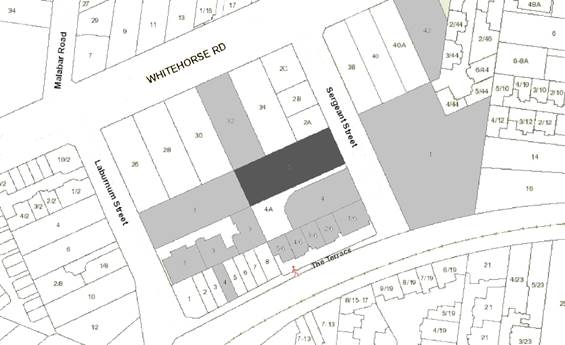
|
|
|
Subject site
|
|
22 Objector Properties
(8 outside of map)
|
é
North
|
BACKGROUND
The Site and Surrounds
The site is located at 2 Sergeant
Street, Blackburn and comprises one allotment, being Lot 11 on Plan of
Subdivision 6826, Volume 1161981, and Folio 317. The site is situated on
the western side of Sergeant Street, and has the following key features:
· The
site is regular in shape with a frontage width of 22.86 metres, side
boundaries (north and south) length of 60.35 metres and a site area of
approximately 1380 square metres.
· The
subject site is currently vacant and has no vegetation except for one existing
canopy tree, a Corymbia citriofora, Lemon-scented Gum (Tree 1), located within
the site’s frontage. Refer to Figure 1 – Aerial photograph, below.
· The
land has a slope of 1.3 metres falling from north-east (front) to the
south-west (rear) corner of the site.
· There
are no existing street trees located along the subject site’s frontage.
· A 1.52
metre wide drainage easement extends along the western (rear) boundary of the
site.
· The
site is located within an established residential area. The street
contains a mix of traditional detached dwellings, dual occupancies, attached
contemporary two-storey townhouses, row developments and multi storey apartment
development.
· Sergeant
Street is a two way street with kerbside parallel parking on either side.
It extends from Whitehorse Road and terminates in a courtbowl at the railway
line.
· Along
the railway line is a walking track through to Laburnum Station from the end of
Sergeant Street.
· The
site is located in proximity to a range of commercial and community facilities
including:
o Laburnum
Village neighbourhood centre is located within walking distance of the subject
site, approximately 250 metres south-west by foot;
o Middleborough
Road and Whitehorse Road shops 300 metres to the west;
o Blackburn
Neighbourhood Centre / Megamile activity centre 600 metres to the east;
o Box
Hill Activity Centre 1.5 kilometes to the west;
o Laburnum
train station and Blackburn train station 150 and 500 metres respectively from
the site.
o Various
bus routes, areas of public open space and educational facilities.
· The wider area
comprises both low-rise (4-5 storey) as well as a mix single and double storey
dwellings.
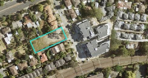
Figure 1 – Aerial photograph
Planning
Controls
The subject site is zoned Residential
Growth Zone – Schedule 2 (RGZ2).
There are multiple purposes to the
Residential Growth Zone including:
· To
provide housing at increased densities in buildings up to and including four
storey buildings.
· To
encourage a diversity of housing types in locations offering good access to
services and transport including activity centres and town centres.
· To
encourage a scale of development that provides a transition between areas of
more intensive use and development and other residential areas.
A planning permit is required for the
construction of two or more dwellings on a lot in the RGZ2.
The site is included in the
Significant Landscape Overlay – Schedule 9 (SLO9).
The purpose of the Significant
Landscape Overlay includes:
· To
implement the Municipal Planning Strategy and the Planning Policy Framework.
· To
identify significant landscapes.
· To
conserve and enhance the character of significant landscapes.
Pursuant to Schedule 9 of the
Significant Landscape Overlay, a planning permit is required to
‘construct a building or carry out works within 4 metres from the base of
any tree protected under the provisions of this Schedule 9.
PROPOSAL
It is proposed to construct a
four-storey building (comprising of 22 dwellings) over one level of basement
car parking. The vehicle accessway is to be altered by removal of the
existing crossover and relocating it to south-east corner of the site.
The main components of the
application are:
· Number
of dwellings – 22 dwellings, comprising of eighteen (18) two bedrooms and
four (4) three bedroom dwellings.
· Car
parking – 26 resident car parking spaces within basement level. No
visitor parking provided.
· Bicycle
parking – 24 bicycle parking spaces, comprising of 22 residents and 2
visitors spaces, located within the lobby entrance area.
· Maximum
building height – maximum height comprises:
§ 13.80 metres, measured to the
top of the lift over-run.
§ 13.38 metres, at top of
parapet walls.
· Setbacks
– The proposed setbacks from all common boundaries are as follows:
§ Sergeant Street – will
achieve varying front setbacks between 9.1 (ground level) and 7.2 metres at
upper floor levels.
§ Northern boundary –
side setbacks varying between 2.4 and 7.28 metres, with balconies/terraces
encroaching at various points by up to 2.0 metres into the setback.
§ Southern boundary –
side setbacks varying between zero and 7.58 metres, with balconies/terraces
encroaching at various points into the setback.
§ Western (rear) boundary
– setbacks varying between 4.42 metres and 13.82 metres, with the third
floor balcony area of Dwelling 302 encroaching 4.82 metres into this setback.
· Site
coverage – 57 percent (791 square metres).
· Permeability
– 23 percent (317 square metres).
· Vehicular
access – New crossover and vehicular access ramp will be located at the
south-east corner, providing direct access to the basement area.
· Pedestrian
entry – A pedestrian path is provided along Sergeant Street frontage,
directly connecting to the residential lobby area, which abuts the access ramp
(along the south).
· Waste
Storage – A shared refuse and recyclables area is provided within the
ground level area, abutting the entry lobby. Waste proposed to be
collected by private contractor along Sergeant Street frontage.
· Landscaping
– Landscaping features will include:
§ Retention of the existing
canopy Tree 1 (Lemon-scented Gum) within the frontage setback.
§ New canopy trees are proposed
around the site’s periphery, concentrated along the western and southern
boundaries, with taller screening shrubs generally proposed along the northern
boundary.
· Design
details – Design features include:
§ Cladding proposed comprises a
combination of roughcast render profile, profiled aluminium cladding panel,
prefinished fibre cement sheet and a variety of glazed finishes.
§ Planter boxes proposed for
each landing area of the internal stairwell area.
§ Privacy screen, in the form
of verticle trellis proposed external of the stair-well window area (north
elevation)
§ Sub-stations and service
cabinets generally incorporated into the building, or setback from the frontage
to be accessible via the internal lobby area.
§ Post boxes located within the
entry lobby area.
Public Notice
The application was advertised by
mail to the adjacent and nearby property owners and occupiers and by erecting a
notice on the Sergeant Street frontage. At the time of writing this
report a total of 22 objections have been received raising the following
issues:
1. Non-compliance
with the Whitehorse Planning Scheme:
a. Clause 21 (MSS) - Clauses
21.05 (Environment) and 21.06 (Housing)
b. Clause 22 (Local Planning Policies)
- Clauses 22.03 (Residential Development) and 22.04 (Tree Conservation)
c. Clause 32.09 (Residential
Growth Zone) and
d. Clause 42.03 (Significant Landscape
Overlay) with particular reference to the SLO 9 Schedule and Guidelines.
e. Garden Suburban 13
f. Strategic Context, zoning
maximum height 13.5 metres
2. Overdevelopment:
a. Building footprint too large.
b. Lack
of meaningful landscaping/ no opportunity for landscape softening.
c. Loss
of mature trees
3. Amenity
impacts:
a. Overlooking/ loss of privacy
b. Overshadowing
c. Blocking
daylight and sunlight
d. Increase
noise
4. Traffic/Parking:
a. Increase traffic problems in
the area
b. Increase
traffic with additional movements
c. Parking
congestion
d. No
car parking for visitors
e. Single/access
way and entry point
5. Vegetation
and Landscaping:
a. Loss of vegetation/removal of
trees
b. Insufficient
landscaping
6. Others:
a. Set precedents for height and
development scale
b. Devaluation
of property value
c. Incorrect
description of the development at 1-3 Sergeant Street.
d. Errors
in the application documentation
Consultation Forum
A consultation forum was held on the 23rd April
2019. The meeting was chaired by Cr Denise Massoud. Attendees included
the applicant and their consultants, nine (9) objectors and Council planning
officer. All issues raised in objections were discussed, with the, key
issues relating to offsite amenity impacts, including overdevelopment,
overlooking, overshadowing, blocking of daylight, increased noise, all traffic
matters and vegetation/landscaping. No resolution of concerns was achieved at
this meeting.
Referrals
External
The application was not required to
be referred to any external authorities or agencies.
Internal
Engineering and Environmental
Services Department
· Transport
Engineer
The proposal was referred to
Council’s Transport Engineers who do not object to the proposed
development, subject to the inclusion of conditions on any approval issued.
· Waste
Engineer
The proposal was referred to
Council’s Waste Services Engineers who do not support waste collection
from the front of the site in the road reservation. Consequently, it is required
that all collection to occur internal to the development. This can be
addressed by way of permit condition, should any approval is issued.
· Assets
Engineer
Council’s Asset Engineers has
reviewed the proposed plans and provided no objection to the proposal, subject
to conditions on any approval issued.
Planning Arborist
The proposal was referred to
Council’s Planning Arborist who does not object to the proposed
development, subject to the inclusion of conditions on any approval issued.
ESD Advisor
The proposal was referred to
Council's ESD Advisor who does not object subject to the inclusion of
conditions on any approval issued.
DISCUSSION
The proposal has been assessed
against the relevant state and local planning policies, the zone and overlay
and the relevant particular provisions and general provisions of the Whitehorse
Planning Scheme.
The following assessment is made
under the headings of:
· Planning
Policy Framework;
· Neighbourhood
Character, Built Form and Amenity Impacts;
· Car
Parking and Traffic;
· Other
matters, and
· Objector
concerns.
Planning Policy Framework
Key objectives of the PPF and LPPF
seek to identify appropriate areas for housing growth, including a focus on
increasing housing densities in areas surrounding existing services, jobs,
public transport and infrastructure in order to accommodate Melbourne’s
future population growth in a sustainable manner.
Clause 15.01-1R (Urban Design -
Metropolitan Melbourne) and 15.01-2S (Building Design) continue to require assessment
of matters such as urban design, suitability of design response to context, and
minimising detrimental impacts on amenity. Such matters are discussed in
further detail within the assessment sections to follow.
These objectives are further developed
at a local level through the Local Planning Policy Framework, particularly the
policy at Clause 21.03, A Vision for City of Whitehorse. Clause 21.03 Housing
recognises the need to reduce developmental pressure on areas of
established environmental significance, through appropriate infill development
and consolidation. This is implemented through the separation of
Whitehorse’s residential land into three residential categories of
housing change (minimal, natural and substantial change), aligned with the
neighbourhood character statements for each area of the municipality. The
substantial change category seeks to focus increased housing densities around
activity centres and main roads, where maximum facilities and services are
available.
The subject site is located within a
Substantial Change area. The higher density outcomes for Substantial Change
areas are further supported through Council’s Local Policy outlined at
Clause 22.03 – Residential Development, which encourages the preferred built
form to be flats and apartments.
Due to the site’s location and
proximity to Laburnum Train Station, the Laburnum shopping centre, which has
been identified as a Neighbourhood Activity Centre (Clause 21.06 –
Housing), and Whitehorse Road, the site is considered appropriate for
‘apartment style’ developments, and more intense building forms.
Contextually, the site meets the
fundamental principles for urban consolidation which are sought at both the
State and Local levels. High quality urban design outcomes are achieved in that
the proposed development contributes positively to the public realm and urban
fabric through a mix of contemporary building form, scale and mass that steps
down with the topography of the site, and materials that soften the modulated
form. The development proposes a scale and intensity, subject to some minor
design form changes, which is considered appropriate to the neighbourhood and
site context, and is generally consistent with the strategic intentions of
local policies.
The Residential Growth Zoning
applicable to the site encourages increased densities within apartment
buildings of up to, and including four storeys and with heights of up to 13.5
metres. The development achieves this by providing a maximum building height, measured
to the top parapet wall, of 13.38 metres, below the preferred height limit. The
site area of 1380 square metres and frontage width supports a greater intensity
of built form. The development also offers increased housing diversity to
support the changing demographics and ageing population, and greater housing
choice from the traditional single homes evident in the surrounding area.
The proposed development, having been
assessed against the relevant provisions of the Planning Scheme including the policy
directions contained in the PPF, MSS and LPPF reflects the type of residential
outcomes sought within this location, and is appropriate given this strategic
context.
Neighbourhood Character, Built
Form and Amenity
The proposal is considered to meet
the relevant provisions of Clause 55 – Two or More Dwellings on a Lot and
Residential Building. The key matters are discussed in the following
section of the report.
Neighbourhood Character
Contextually, the site meets the
fundamental principles for urban consolidation which are sought at both the
State and Local levels. It should be noted that, the character of the
broader neighbourhood is quite varied, seeing an amalgamation of single homes,
medium density housing and higher density “apartment” style
development. New development is steadily emerging along both Sergeant Street
and the wider area between Blackburn and Laburnum Train Station, with building
scales and heights increasing in the east-ward approach into Blackburn Activity
Centre.
The proposal provides for a high
quality urban design outcome which would contribute positively to the existing
public realm and urban fabric. The development proposes a scale and
intensity which is appropriate to the neighbourhood and site context, and is generally
consistent with the strategic intentions of local policies, for redevelopment
of up to four storeys in scale.
The development meets the
expectations for outcomes sought for this area and subject to conditions can
achieve compliance with the building setbacks as outlined at Standard B17
(ResCode), further discussed below.
Integration with the Street
The proposal provides an acceptable
presentation to the street, with upper levels stepped back to modify the
building’s overall scale. Subject to minor modification, the upper
level façade treatments will provide both vertical and horizontal articulation
across the building.
The building has a less traditional form than typically seen
in apartment design in the area. From the street frontage, it adopts a very
uniform module and palette selection, with extensive glazing surfaces and a
light roughcast framing border, creating a distinct podium feel. The
building has a balanced form and scale, with minor variation at ground level,
and the entry foyer located to one side of the building adding a subtle
variation, without appearing foreign to the building rhythm.
The balconies at first and second
floor of the building above appear as “floating” elements, which
highlight its sense of address and entry.
The graduation of colouring from dark
to light achieves a sense of articulation and ensures the overall appearance is
not too heavy, or monotonous. It is also well balanced with strong glazing
elements.
The architectural presentation
overall is considered attractive and of high quality. The rear elevation and
side elevations in part are treated quite differently. The darker colour,
aluminium cladding is used quite prominently across the two middle levels of
the south, and northern elevations, though broken up with an equal use of light
grey fibre cement sheet cladding.
The western elevation is quite
heavily finished in the dark grey aluminium cladding. There are bands of
the aluminium featured across the first and second floor levels and a mixture
of tinted and clear glazing, to window openings, which are generally relied
upon to break-up this elevation and provide interest.
Whilst the high use of the dark grey
aluminium cladding upon the northern and southern elevations may make the
building more understated and subdued within the landscape, it may also appear
quite stark and repetitive. To add depth to the dark/grey toned colour palette,
a condition will require the inclusion of some warmer/lighter colour tones.
Subtle material changes could reasonably achieve this outcome by way of
alternative privacy screen colours or warmer timber look materials on the
under-side of balconies.
Built Form
Street Setback
The building is setback a minimum
of 8.9 metres and the proposed southern boundary wall is setback a minimum of
17 metres from Sergeant Street frontage, at ground level. These setbacks
meet the varied Standard B6 requirements, outlined in Schedule 2 of the
Residential Growth Zone. Furthermore, the proposed setback exceeds the
average setback of north, and southern property where a minimum of 8.6 metres
is required.
At the first and second floor level,
the balconies of Dwellings 101 and 201, encroach approximately 1.8 metres into
this setback. As these balconies are situated 3.6 metres high, the
proposal seeks a variation to the front setback requirement at these
levels. Overall, this encroachment into the prescribed minimum front
setback is considered minor and is acceptable, as both balconies in this
instance present as being absorbed into the main building footprint. This
is due to the slight recess of the balconies and the use of transparent
balustrade along the street frontage. This assists in minimising the bulk and
solidness of the balconies, and further creating a floating affect which helps
to maintain a visual impression of a more substantial front setback overall.
Building Height
The building has a maximum height
of 13.38 metres, measured to the top of the parapet wall (south elevation),
with the lift over-run extending 0.42 metres above this, measuring 13.8
metres. The overall height is consistent with the zoning intention, and
is appropriate with regards to this specific site and neighbourhood
context. The sectional diagrams submitted with the application
demonstrate that the more substantial four storey building heights are confined
centrally within the site, and are adequately setback from all the shared
common boundaries. At the periphery, the built form is confined to either
a single storey built form height, or has achieved a minimum setback of 4.20
metres, where the height increases.
The width and size of the site allows
for a four storey building scale with graduated setbacks from the side and rear
boundaries. The “stepping” of the building down toward the
rear and side boundaries is an appropriate design response, particularly given
the fall within the land, and gives due consideration to the amenity of the
adjoining properties and anticipated future built form.
The fourth storey is also
appropriately treated in a contrasting lighter colour to the aluminium cladding
panel on lower levels, (dark-grey colour) to provide a “capping”
effect, which acts to reduce the perceived height, whilst contributing to the
overall interest and design detailing. Its location is suitably inset from the
side boundaries, and is a recessive element to both the streetscape and
neighbouring perspectives.
It is also considered that the
proposal suitably meets the intent of the building height objective, outlined
at Clause 55.03-2 (Standard B7).
Site Coverage
It has been submitted by the
applicant that the proposed building has a site coverage of approximately 57%
(791 square metres). However, a review of the basement floor plan
suggests a larger building footprint, with a difference in area of
approximately 100 square metres. Consequently, Officer assessment is that
the site coverage is approximately 65%, 898 square metres, not 57% as outlined
in the development schedule provided by the permit applicant. Standard B8
states that the site area covered by building should not exceed 60%. As
the proposal seeks to exceed the nominated coverage, a variation to this standard
is required.
The surrounding area exhibits many
multi dwelling development sites, including recent apartment developments,
which comprises of built form that extends deep into each of the respective
allotment(s). Subsequently, this is a reflection of an area undergoing
transition with higher density development, which has resulted in built form of
higher density and coverage. Therefore, the proposed development at 65%
site coverage, is considered an appropriate design response and reflective of the
high density built form within the immediate context of the site. That
said, the centralised design/built form of the proposal, together with
sufficient setbacks from all boundaries, has enabled the proposal to provide
reasonable landscaping opportunities, which echoes the softer character
elements within Sergeant Street and its surrounds.
From the perspective of the
relevant ResCode standard, the proposal has provided for a building
and hard surface coverage under the 80%, maximum allowable under Standard B9,
whilst at the same time providing for adequate level of deep soil planting
areas along the side and rear setbacks, ensuring appropriate level of
permeability is maintained onsite.
Side and Rear Setbacks
Along the northern interface, in
the location of Dwelling 204 on the second floor, the building (parapet wall)
reaches a height of 9.63 metres and is setback 4.20 metres in lieu of the 4.72
metres. Similarly, Dwelling 302 on the third floor is setback 7.28 in
lieu of 7.47 metres. It is not considered that the above non-compliances
would result in detriment to the abutting properties to the north.
However, of concern are the non-compliances attributed with the locations of
the balcony areas associated with the north facing dwellings, at the first and
second floor level, which encroach 2.0 metres into the northern setbacks.
Consequently, it is considered that
modification to the upper level built form, along the northern elevation, is
required to address further setbacks of all north facing balconies from this
interface to achieve a fair and equitable development setback and to avoid
amenity impact to the existing dwellings at 2A Sergeant Street and 32-34
Whitehorse Road. To achieve this, it is considered that the following
changes should be incorporated into current layout:
The balcony areas associated with
Dwellings 102, 103, 104 at first floor and Apartments 202, 203 and 204 at
second floor, be setback a minimum of 3.5 metres from the northern
boundary. This is to be achieved either through the relocation of these
balconies, providing further recession or a combination of both.
Subject to the above changes, it is
considered that the proposed built form would ensure that equitable development
opportunity is offered for the adjoining property to the north of site and will
not result in additional detriment.
At the southern interface, the
current proposal exhibits similar non-compliances. At this interface
however, the site abuts a common driveway, for the majority of the southern
boundary length. It is therefore considered that the non-compliances
associated with the setback would not result in unacceptable amenity impacts to
the existing dwellings 4 and 4A Sergeant Street through shadowing.
From an equitable development
perspective however, it is considered that all balconies along this southern
interface should be setback a minimum of 4.5 metres. Similar to the
northern interface, a condition for any permit approval should require the
balcony areas associated with Dwellings 105, 106 and107 at first floor and
Apartments 205, 206 and 207 at second floor, be setback a minimum of 4.5 metres
from the southern boundary. This is to be achieved either through the
relocation of these balconies, providing further recession, or a combination of
both.
Overall, subject to the above
changes, it is considered that the proposed built form would ensure that
equitable development opportunities are offered for the adjoining properties to
the north and south of the site and will further reduce any perception or
measure of detriment.
Amenity
Impacts
Overshadowing
Based on the submitted shadow
diagrams, areas in excess of 40 square metres of all adjoining secluded private
open space areas will continue to receive at least 5 hours of sunlight between
9am and 3pm during the September Equinox. Whilst the properties to the south
will experience some shadowing during the “measurable time period”,
the shadows cast are mainly over the common driveway area, only extending
marginally beyond the existing fence shadows with some additional shadows over
the northern wall of 4 Sergeant Street. The vast majority of the total
private open spaces, of both dwellings (4 and 4A Sergeant Street), remain
unaffected.
Notwithstanding this, it is unclear in relation to the extent
of shadow effect on the existing north facing habitable windows of the property
at 4 Sergeant Street. To ensure that these windows are not unduly
affected, a condition of permit will require a sectional diagram showing the
extent of shadow cast, vertically along this elevation, to the satisfaction of
the Responsible Authority.
Shadowing to the adjoining property to the west and south
west appears to only occur between 9-10am, however impacts only affect small
segments along the rear boundary of the property, again leaving the majority of
the total area unaffected.
Overlooking
Screening devices overall have been
suitably selected to maintain a good balance between neighbouring privacy and
internal amenity. However, there is a general absence of detailing regarding
the type and appearance of screening devices to affected balconies and windows.
Such detailing will be required via condition.
Internal Views
A condition will require plans
detailing dividing balcony walls to ensure privacy is achieved. The internally
facing balconies are substantially separated which negates the need for
screening.
Energy efficiency
An SMP has been submitted with the
application, which will require further detailing and some modifications prior
to approval. The approved sustainability measures will be required to be
incorporated into the building’s design.
Given the orientation of the site, it
is inevitable that there would be common living areas of the southern dwellings
oriented to face the southern boundary. Subsequently, the orientation of the
building on the lot has maximised available solar access, where possible.
The western elevation does feature
some highly exposed windows between the ground and third storey which are only
partly inset into the external wall cladding, and therefore require solar
treatment.
A condition to any approval granted
will therefore require a more appropriate design which achieves solar
protection and shading (such as vertical louvres) for all west facing windows
of the development.
Deep soil areas and canopy trees
The proposal provides an area of approximately 370 square
metres of deep soil planting, along the building setbacks areas, exceeding the
required 7.5% (approximately 103.5 square metres) specified under Clause
55.07-4. Planting within the easement area, on the west (rear) boundary
cannot be supported. Excluding the west boundary planting, the proposal
will provide for an area of approximately 163.4 square metres of deep soil area
within the frontage setback, achieving compliance. Furthermore, the
retention of the canopy tree (Tree 1, Lemon Scented Gum) within the frontage
setback of the site is considered an additional benefit of the development.
It should be noted that Sergeant Street, and the surrounding
area, is not characterised by a dominant landscape theme, furthermore, the
zoning of the land (RGZ) contemplates more intensive developments with compact
and robust built form for the site. Notwithstanding this, the submitted
landscape concept plan is considered acceptable and meets objectives of
Council’s Tree Conservation Policy (Clause 22.04) through provision of
adequate landscape areas to assist in the softening of the built form and enhance
the amenity of the area.
A landscape concept design has been submitted to demonstrate
a potential planting theme for the site, with sufficient setbacks (minimum 2.2
metres) to provide deep soil zones to support a good level of planting
throughout the periphery of the site, with the exception of the front half of
the southern boundary of the site. A more formalised plan will be required by
way of condition to demonstrate the precise numbers and locations of plants,
and ensure that the existing tree indicated within the frontage is adequately
protected.
Similarly, to ensure neighbouring trees within proximity to
the site are not adversely impacted, the recommendations of the Arborist report
will be implied via condition
Private open space above ground floor
The proposed balconies are
generally compliant with the minimum area requirement, however it is unclear
whether some of the balconies achieve compliance with the minimum width
(dimension) specified under Standard B43 (Private open space above ground
floor). This can be addressed by way of permit condition, requiring full
compliance with Standard B43.
Natural ventilation
All habitable rooms within the
development benefit from direct solar access, ensuring there is no reliance on
borrowed light. Maximum breeze paths not exceeding 18 metres are provided
through dwellings which will provide effective cross-ventilation. These
breeze paths are measured from openings on different orientations of the
building. However, it is considered that the development would further
benefit from provision of additional windows in habitable rooms throughout the
development to provide further cross ventilation of internal spaces. This
can be achieved through permit conditions requiring modification to plans.
Car Parking and Traffic
The planning scheme (through
Amendment VC148) and in particular Clause 52.06, specify Column B rates
applicable to the assessment of the proposal (as the land is identified within
the Principal Public Transport Network Area (PPTN)). The proposal does
not require the provision of visitor parking as a result of VC148 amendment,
and as such the statutory requirements are fully complied with. The
proposal will provide for the following car parking allocation onsite:
|
Usage
|
Number
|
Rate
|
Required Spaces
|
Spaces Provided
|
|
Dwellings
|
|
|
|
|
|
· 2
bedroom dwellings
|
18
|
1 space
per dwelling
|
18
|
18
|
|
· 3+
Bedroom dwellings
|
4
|
2 spaces
per dwelling
|
8
|
8
|
|
· Visitor
parking
|
0
|
0
|
0
|
0
|
|
|
|
Total
spaces required
|
26
|
26
|
Council’s Transport Engineers
are also satisfied that the onsite parking provision is sufficient to support
the car parking demand, in accordance with the Planning Scheme requirements.
Conditions also list requirements for
functional and efficient layout for the basement car parking area.
Similarly, conditions of permit also
address the proposed ramp grades to meet the design requirements of AS 2890.2,
provision of a swept path diagram of the design vehicle accessing the loading
area is required and the required headroom clearance specified in AS 2890.3.
Car parking facilities are securely
located within the basement and provide for direct access into the lobby area
and all levels, via the lift cores and stairwells.
Ventilation to the basement level
is provided via mechanical means. Habitable room windows on the abutting
property to the south is located with a setback of approximately 4.1 metres
from the accessway, hence it is not anticipated that these windows would
experience unreasonable adverse noise impacts from the use of the accessway.
In relation to objector concerns
relating to traffic generation and congestion, Council’s Transport
Engineers have commented that car parking facilities are satisfactory and
traffic generated by this development can be accommodated in the surrounding
street network.
With respect to objector concerns
relating to no visitor parking provision onsite, it is noted that the proposal
is exempt from the need to provide visitor parking, as the site is located
within the PTTN.
Other Matters
As has been discussed earlier in
this assessment, there is an emergence of apartment developments both
constructed and approved within the surrounding area of Blackburn and
particularly within proximity to the Laburnum train station. Of relevance
however, is the recent VCAT case for a proposed apartment building in Downing
Street, Blackburn. In this decision the Tribunal was critical in its assessment
of the development for its poor response to side setbacks, interfaces to
adjoining residential properties and lack of landscaping opportunities. The
VCAT final order, provided the following commentary in its written order:
· Whilst
‘it is to be expected that a multi-level apartment-style development
as envisaged by the purpose of the RGZ2 and by policy for substantial change
areas will stand in marked contrast to the original dwelling stock which
characterises Downing Street and the surrounding neighbourhood.’ The
member further noted that this ‘does not mean that the site’s
constraints and context can be disregarded. Achieving the outcomes sought
by policy will mean that development will need to respond in a meaningful way
to the site and its surrounds’.
· ‘The
height and setbacks of the development do not respond acceptably to the
frontage and to the northern boundary, in particular, resulting in it
manifesting a dominant presence within its context’. Of
particular concern was the level of non-compliance associated with front
setbacks (Standard B6) and the side and rear setbacks (Standard B17).
‘The required third-floor setback from the common boundary with this
property in order to meet standard B17 ranges between 9.6 metres at the western
end of the building to 8.6 metres at the eastern end. A minimum 3.7-metre
setback is proposed. At the second floor level, the setback required to
meet standard B17 ranges from 5.19 metres at the eastern end to 6.19 metres at
the western end. Again, a minimum 3.7 metre setback is proposed. At
this setback, the development is positioned too close to the boundary and will
have an overpowering presence when viewed from the neighbouring property.
An unacceptable level of visual bulk and mass will be presented’.
· The
extent of tree removal was also of particular concern, with a total of 19 trees
identified for removal in that proposal.
· In
light of the above, the VCAT Member considered the proposed design as having
‘the appearance of “crowding” the site’
and not ‘a site-responsive design’.
In comparing the current proposal, at
2 Sergeant Street, to the above case, the following noticeable differences are
evident:
i. The
subject site (2 Sergeant Street) has a greater frontage width, being 22.86
metres instead of 15.24 metres.
ii. The
proposal provides a front setback of 8.9 metres, at ground level, which exceeds
the requirement specified under Standard B6. Whilst the proposal seeks a
variation to the front setback requirement at the first and second-floor level,
resulting from balcony encroachments, these encroachments are considered
minimal and can be adequately absorbed into the building footprint, to not
appear dominant when viewed along Sergeant Street interface.
iii. It
is acknowledged that the current proposal would result in non-compliance with
Standard B17, up to 2.5 metres in various parts of the development, as a result
of balcony encroachments. However, given the width of the site,
conditions of permit require these setbacks to be increased. The nature of
such conditions has been discussed in the earlier section of this report.
iv. The
proposed landscape plan adequately demonstrates the planting theme for the
site, particularly through the provision of adequate landscaping areas
throughout the side and rear boundaries and within the frontage setback. This
is able to be achieved to a greater extent than that for 20 Downing Street because
of the increase setbacks from the front and rear boundaries.
v. The
proposed development does not involve the removal of any canopy trees
onsite. The proposal enables the retention of the existing canopy tree
within the frontage setback of the proposed building. This is considered
consistent with Council’s Tree Conservation Policy (Clause 22.04) and the
Significant Landscape Overlay – Schedule 9 (SLO9), and is a feature of
the site that enables the integration of the development into the surrounding
neighbourhood.
The commentary provided by the VCAT
member for the Downing Street decision is relevant in recognising the
importance of finding the right balance between increased building density
within a RGZ and landscaping opportunities. The proposal being considered in
this report is considerably different, both in terms of context and site
constraints. Overall, the proposal, subject to conditions, would present
adequately to the Sergeant Street context, in terms of bulk, scale, setbacks
and landscaping, providing greater softening of the building to the key
interfaces and as such responds to the neighbourhood character of the wider
Blackburn area.
Objectors concerns not previous
addressed
· Removal
of existing trees onsite
The site has no vegetation present
except for the large canopy tree at the front of the site. This canopy tree is
to be retained as part of the development. A review of historic aerial photos
show that the site has been devoid of vegetation since around 2014. The
redevelopment of this site is supported by State and Local Policies, and
Council’s strategic direction provides for other residential zones and
policy categories to be the primary area for the retention of trees and
habitat. Tree retention and planting is not the critical focus of
residential growth zone, where intensive development is prioritised, especially
when well serviced by public transport (train station), however the retention
of the existing canopy tree will make a contribution to the streetscape and
broader landscape.
· Noise
and Construction Noise
The residential use of the site does
not require a planning permit. Residential noise associated with a dwelling is
considered normal in an urban setting. Any future issues of noise emission can
be pursued as a civil matter, by reference to EPA regulations and the Health
Act.
It is acknowledged off site impacts
are inevitable when any construction occurs. To manage any future offsite
amenity impacts during construction, a Construction Management Plan will be
required as a condition of any approval granted.
In addition, the permit holder will
be required to meet all relevant Building and EPA regulations during the
construction stage.
· Set
precedents for height and development scale
The Residential Growth Zone allows
for development up to four storeys in height (or greater). This proposal
complies with these requirements.
Regardless, each application is
assessed in relation to the relevant planning controls, its site context, the
prevailing neighbourhood character and merits of the development design.
· Devaluation of property value
The Victorian Civil
and Administrative Tribunal and its predecessors have generally found
subjective claims that a proposal will reduce property values are difficult, if
not impossible to gauge and of no assistance to the determination of a planning
permit application. It is considered the impacts of a proposal are best
assessed through an assessment of the amenity implications rather than any
impacts upon property values.
· Incorrect
description of the development at 1-3 Sergeant Street and Errors in the
application documentation
During the Consultation Forum meeting
several concerns were raised by adjoining properties owners, suggesting that
there are anomalies with regard to the description of the development at 1-3
Sergeant Street (opposite the subject site). Additionally, it was further
suggested that there are inconsistencies with the windows, open space and trees
on the adjoining properties, in particular the western and south-west properties.
However, it is unclear if this refers to the plans, or accompanying written
submission. The information has been derived from a Licensed Surveyor and
appears generally consistent with site conditions. Albeit, the plans will
ensure compliance is achieved with respect to overlooking toward this property,
and sufficient boundary setbacks are maintained from the common boundaries.
CONCLUSION
The proposed buildings and works to
construct a four storey building to provide 22 dwellings is an acceptable response
and achieve satisfactory compliance with the relevant planning provisions,
including the State and Local planning policies, the purpose and decision
guidelines of the Residential Growth Zone and Clause 55 – Two or more
dwellings on a Lot and Residential Buildings.
Notably, the proposal achieves the
State Government’s urban consolidation objectives, Council’s
preference to direct higher density residential development within principal
transport nodes (Laburnum Train Station), contributing to meeting
Whitehorse’s future housing needs.
The building has been designed to
respond to the site’s varying interfaces, to provide a high level of
amenity for future residents and to activate the street frontage.
A total of twenty two (22) objections
were received as a result of public notice and all of the issues raised have
been considered as part of this assessment.
Council was notified on the 29th of August, 2019
that the applicant had appealed to VCAT against Council’s failure to
determine the application within the prescribed statutory timeframe.
However, were council in a position to determine the application, it is
recommended that the application be approved, subject to conditions
Attachment
1 Architectural
Plans ⇨ 
2 Landscape Plan ⇨
Ordinary Council Minutes 16
September 2019
9.1.3 92
Kenmare Street, Mont Albert (Lot 98 LP 8375) Construction of three double
storey dwellings with basement garages and associated tree removal
FILE NUMBER: WH/2018/1044
ATTACHMENT
SUMMARY
This application was originally
advertised in January 2019 and a total of 15 objections were received,
including an objection from Melbourne Water. In order to address
Melbourne Water’s concerns, the development was redesigned and
re-advertised in June, attracting seven further submissions from original
objectors, but also resulting in Melbourne Water withdrawing its objection. The
objections raised issues with amenity impacts, neighbourhood character, car
parking, traffic, landscaping and flooding. A Consultation Forum was held on 25
July, 2019, chaired by Councillor Liu, at which the issues were
explored, however no resolution was reached between the parties. This report
assesses the application against the relevant provisions of the Whitehorse
Planning Scheme, as well as the objector concerns. It is recommended that
the application be supported, subject to conditions.
|
Council
Resolution
Moved by Cr Liu, Seconded
by Cr Barker
That Council:
A Being the Responsible Authority, having
caused Application WH/2018/1044 for 92 Kenmare Street, MONT ALBERT (LOT 98 LP
8375) to be advertised and having received and noted the objections is of the
opinion that the granting of a Planning Permit for the construction of three
double storey dwellings with basement garages and associated tree removal is
acceptable and should not unreasonably impact the amenity of adjacent
properties.
B Issue a Notice of Decision to Grant a
Permit under the Whitehorse Planning Scheme to the land described as 92
Kenmare Street, MONT ALBERT (LOT 98 LP 8375) for the construction of three
double storey dwellings with basement garages and associated tree removal,
subject to the following conditions:
1. Before
the development starts, or vegetation removed, amended plans must be
submitted to and approved by the Responsible Authority in a digital
format. When approved, the plans will be endorsed and will then form
part of the permit. The plans must be drawn scale, and be generally in
accordance with the plans submitted with the application but modified to
show:
a) Any
alterations to plans required to meet Melbourne Water’s conditions, and
written confirmation from Melbourne Water that the plans are compliant.
b) The
locations of the Structural Root Zone and Tree Protection Zones described in
condition 5, with all nominated trees clearly identified and numbered on both
site and landscape plans, and the requirements of conditions 5 and 6 to be
annotated on the development and landscape plans.
c) The
location of all service trenches to serve the dwellings (for example: gas,
water, electricity, stormwater, sewerage, telecommunications), including the
extent of trenching required in easements over adjoining lots (if any) and
the locations of protected trees within 4 metres of these trenches (if any).
The service trenches must be located and dug (including boring or hand
digging) to ensure that protected trees are not damaged, to the satisfaction
of the Responsible Authority.
d) Swept
path diagrams using a B85 design vehicle template (AS 2890.1 2004) prepared
by a suitably qualified traffic engineer using industry-recognised swept path
software to be provided to demonstrate compliant vehicle turning movements to
and from Garage 1.
e) The
pedestrian door to Garage 3 must not swing into the parking area.
f) Plans
to show compliant garage dimensions and door opening widths.
g) The
length of the 1:8 grade at the southern end of the accessway to be extended
to 2.5 metres to avoid vehicle scraping.
h) The
headroom clearance to be shown at a minimum of 2.1 metres on the elevations.
i) The
Dwelling 2 retreat windows on the west elevation to be screened with fixed
opaque glazing up to 1.7 metres above finished floor level.
j) The
heights of east and west side boundary fences to be tapered to 1.2 metres
high forward of Dwelling 1
k) Details
of any external services (i.e; heating, cooling, hot water, etc) and the
location of service meters.
l) Development
plans to reflect all sustainability features indicated in the submitted,
amended and approved Sustainability Design Assessment (SDA). Where
features cannot be visually shown, include a notes table providing details of
the requirements (i.e. energy and water efficiency ratings for
heating/cooling systems and plumbing fixtures, etc.).
m) Alterations
to the plans required by the amended Waste Management Plan, as required.
n) The
cladding colours and materials schedule updated to indicate that all obscured
glazing be manufactured obscured glass.
o) An
amended landscape plan to show:
i. The
trees to be planted to be a mix of indigenous and exotic species.
ii. The
retention of Tree 3 and the western portion of the Tree 2 hedge, and
associated alterations to the proposed plantings.
iii. The
proposed row of closely planted Pyrus ‘Capital’ in the frontage
to be amended to provide a minimum 3 metre separation between trees and
Dwelling 1, and to provide for tree spacing that will allow for mature tree
canopy growth.
All of the above must be
to the satisfaction of the Responsible Authority. Once approved these plans
become the endorsed plans of this permit.
2. The
layout of the site and the size, design and location of the buildings and
works permitted must always accord with the endorsed plan and must not be
altered or modified without the further written consent of the Responsible
Authority.
3. Landscaping
and tree planting must be undertaken in accordance with the endorsed
landscape plan that forms part of this permit, to the satisfaction of the
Responsible Authority.
4. The
garden areas shown on the endorsed plan must only be used as gardens and must
be maintained in a proper, tidy and healthy condition to the satisfaction of
the Responsible Authority. Should any tree or shrub be removed or
destroyed it may be required to be replaced by a tree or shrub of similar
size and variety.
5. Prior
to commencement of any building or demolition works on the land, a Tree
Protection Zones (TPZs) must be established on the subject site and nature
strip and maintained during, and until completion of, all buildings and works
including landscaping, around the following trees in accordance with the
distances and measures specified below, to the satisfaction of the
Responsible Authority:
a) Tree
Protection Zone distances:
i. Tree 1 (Lophestemon confertus) – 2.0 metre radius from the
centre of the tree base.
ii. Tree 2 western portion of hedge (Pittosporum eugenoides) –
2.0 metre radius from the centre of the tree base.
iii. Tree 3 (Fraxinus angustifolia) – 3.0 metre radius from the
centre of the tree base.
iv. Tree 15 (Syzygium smithii) –
5.0 metre radius from the centre of the tree base.
v. Tree 17 (Liquidambar styraciflua) – 6.7 metre radius from the centre of the tree base.
vi. Tree 18 (Jacaranda mimosifolia) – 2.4 metre radius from the
centre of the tree base.
vii. Tree A (Ligustrum lucidum, location referenced in Appendix 1)
– 2.0 metre radius from the centre of the tree base.
b) Tree
Protection Zone measures are to be established in accordance with Australian
Standard 4970-2009 and are to include the following:
i. Erection
of solid chain mesh or similar type fencing at a minimum height of 1.8 metres
in height held in place with concrete feet.
ii. Signage
placed around the outer edge of perimeter the fencing identifying the area as
a TPZ. The signage should be visible from within the development, with the
lettering complying with AS 1319.
iii. Mulch
across the surface of the TPZ to a depth of 100mm and undertake supplementary
provide watering/irrigation within the TPZ, prior and during any works performed.
iv. No
excavation, constructions works or activities, grade changes, surface
treatments or storage of materials of any kind are permitted within the TPZ
unless otherwise approved within this permit or further approved in writing
by the Responsible Authority.
v. All
supports and bracing should be outside the TPZ and any excavation for
supports or bracing should avoid damaging roots where possible.
vi. No
trenching is allowed within the TPZ for the installation of utility services
unless tree sensitive installation methods such as boring have been approved
by the Responsible Authority.
vii. Where
construction is approved within the TPZ, fencing and mulching should be
placed at the outer point of the construction area.
viii. Where
there are approved works within the TPZ, it may only be reduced to the
required amount by an authorized person only during approved construction
within the TPZ, and must be restored in accordance with the above
requirements at all other times.
6. During
construction of any buildings, or during other works, the following tree
protection requirements are to be adhered to, to the satisfaction of the
Responsible Authority:
a) A
project arborist must be appointed by the applicant or builder. Project
arborist qualifications must read ‘Arboriculture’ for example
‘Diploma in Horticulture (Arboriculture)’. The project arborist
must have a minimum Diploma qualification in arboriculture to be appointed as
the project arborist.
b) For
Trees 3, 15, 17, 18 and A no roots greater than
40mm in diameter are to be cut or damaged during any part of the construction
process.
c) Any
root severance must be approved and undertaken by the Project Arborist using
clean, sharp and sterilised tree root pruning equipment. There must be no
root severance within the SRZs of Trees 3, 15, 17, 18 and A.
d) All
buildings and works for the demolition of the site and construction of the
development (as shown on the endorsed plans) must not alter the existing
ground level or topography of the land (which includes trenching and site
scrapes) within greater than 10% of the TPZs of Trees 15, 17, 18 and A.
e) The
project Arborist must ensure that any root severance or buildings and works
within the TPZs of Trees 3, 15, 17, 18 and A do not adversely impact the
health or stability of the trees now or into the future.
f) The
project arborist and builder must ensure that TPZ Fencing Conditions are
being adhered to throughout the entire building process, including site
demolition, levelling and landscape works.
7. Prior
to the commencement of any buildings or works, an amended Waste Management
Plan must be submitted to and approved by the Responsible Authority.
This Waste Management Plan must be generally in accordance with the Waste
Management Plan submitted with the application but amended to reflect the
approved plans.
Once submitted and
approved to the satisfaction of the Responsible Authority, the Waste
Management Plan will form part of the endorsed plans under this permit.
The requirements of the Waste Management Plan must be implemented by the
owners and occupiers of the site, to the satisfaction of the Responsible
Authority.
8. Prior
to the commencement of any buildings works, an amended Sustainability Design
Assessment (SDA) must be submitted to and approved by the Responsible
Authority. This SDA must be generally in accordance with the SDA
submitted with the application but amended to reflect the approved plans.
Once submitted and
approved to the satisfaction of the Responsible Authority, the SDA will form
part of the endorsed plans under this permit.
The requirements of the
SDA must be demonstrated on the plans and elevations submitted for
endorsement, and the requirements of this plan must be implemented by the
builder, owners and occupiers of the site when constructing and fitting out
the dwellings and for the life of the dwellings, to the satisfaction of the
Responsible Authority.
9. All
works must be undertaken in accordance with the endorsed Sustainable Design
Assessment to the satisfaction of the Responsible Authority, and the approved
dwellings must operate in accordance with this Plan, to the satisfaction of
the Responsible Authority. No alterations to the Reports may occur
without the written consent of the Responsible Authority.
10. Prior
to the commencement of buildings or works on the land, a Construction
Management Plan, detailing how the owner will manage the environmental and
construction issues associated with the development, must be submitted to and
approved by Council.
This plan is to be to
the satisfaction of the Responsible Authority and must be prepared in
accordance with the City of Whitehorse Construction Management Plan
Guidelines.
Once submitted to and
approved by the Responsible Authority the Construction Management Plan will
form part of the documents endorsed as part of this planning permit.
When
approved the Construction Management Plan will form part of this permit and
must be complied with, to the satisfaction of the Responsible Authority, to
the extent that this is in the control of the owner of the land. The owner of
the land is to be responsible for all costs associated with the works to be
undertaken in accordance with the requirements of the Construction Management
Plan.
11. All
stormwater drains and on-site detention systems are to be connected to the
legal point of discharge to the satisfaction of the Responsible Authority
prior to the occupation of the building/s. The requirement for on- site
detention will be noted on your stormwater point of discharge report, or it
might be required as part of the civil plans approval.
12. Detailed
stormwater drainage and/or civil design for the proposed development are to
be prepared by a suitably qualified civil engineer and submitted to the
Responsible Authority for approval prior to occupation of the
development. Plans and calculations are to be submitted with the
application with all levels to Australian Height Datum (AHD). All
documentation is to be signed by the qualified civil engineer.
13. Stormwater
that could adversely affect any adjacent land shall not be discharged from
the subject site onto the surface of the adjacent land.
14. Prior
to works commencing the Applicant/Owner is to submit design plans for all
proposed engineering works external to the site. The plans are to be
submitted as separate engineering drawings for assessment by the Responsible
Authority.
15. The
Applicant/Owner is responsible to pay for all costs associated with
reinstatement and/or alterations to Council or other Public Authority assets
as a result of the development. The Applicant/Owner is responsible to
obtain all relevant permits and consents from Council at least 7 days prior
to the commencement of any works on the land and is to obtain prior specific
written approval for any works involving the alteration of Council or other
Public Authority assets. Adequate protection is to be provided to
Council’s infrastructure prior to works commencing and during the
construction process.
16. The
qualified civil engineer when undertaking civil design must ensure that the
landscape plan/s and drainage plan/s are compatible. The stormwater
drainage and on site detention system must be located outside the tree
protection zone (TPZ) of any trees to be retained.
17. All
treatments to prevent overlooking must not include ‘Translucent
film’ on windows and must be in accordance with Standard B22 of Clause
55.
Melbourne Water
Conditions (Reference: MWA-1138659)
18. Finished
floor levels for dwelling Unit 1, is to be set no lower than 63.85m to
Australian Height Datum (AHD). 300mm above the adjacent flood level of 63.55m
to AHD.
19. Finished
floor levels for Unit 2, dwelling is to be set no lower than 64.25m to
Australian Height Datum (AHD). 300mm above the adjacent flood level of 63.95m
to AHD.
20. Finished
floor levels for Unit 3 dwelling, is to be set no lower than 64.78m to
Australian Height Datum (AHD). 300mm above the adjacent Flood level of 64.48m
to AHD.
21. The
entry/exist to the basement car parking to have a apex set no lower than
63.85 metres to AHD (Apex 300mm above the adjacent flood level of 63.55m to
AHD). Solid walls (flood proofed) must be shown on both sides to the entry to
basement to restrict flood waters entering the basement from the sides.
22. The
basement must be flood proofed & all opening, vents/doors must be set
300mm above the applicable adjacent flood levels.
23. Any
new verandah(s)/decking must be constructed with unenclosed foundations to
allow for the passage of overland flows.
24. Any
new fencing/gates must be of an open style of construction (minimum 50% open)
to allow for the passage of overland flows.
25. Prior
to the issue of an Occupancy Permit, a certified survey plan, showing
finished floor levels (as constructed) reduced to the Australian Height
Datum, must be submitted to Melbourne Water to demonstrate that the floor
& basement car parking entry/exist levels have been constructed in
accordance with Melbourne Water's requirements.
Expiry
26. This
permit will expire if one of the following circumstances applies:
a) The
development is not commenced within two (2) years from the date of issue of
this permit;
b) The
development is not completed within four (4) years from the date of this
permit.
The Responsible
Authority may extend the periods referred to if a request is made in writing
pursuant to the provisions of Section 69 of the Planning and Environment Act
1987.
Permit Notes:
A. The
design and construction of letterboxes is to accord with Australian Standard
AS-NZ 4253-1994.
B. The
lot/unit numbers on the “Endorsed Plan” are not to be used as the
official street address of the property. All street addressing enquiries can
be made by contacting our Property Team on 9262 6470.
Asset
Engineer:
C. The
design and construction of the stormwater drainage system up to the point of
discharge from an allotment is to be approved by the appointed Building
Surveyor. That includes the design and construction of any required
stormwater on-site detention system. The Applicant/Owner is to submit
certification of the design of any required on-site detention system from a
registered consulting engineer (who is listed on the Engineers Australia
National Professional Engineer Register or approved equivalent) to Council as
part of the civil plans approval process.
D. The
requirement for on- site detention will be noted on your stormwater point of
discharge report, or it might be required as part of the civil plans
approval.
E. All
proposed changes to the vehicle crossing are to be constructed in accordance
with the submitted details, Whitehorse Council’s – Vehicle
Crossing General Specifications and standard drawings.
F. Report
and consent – land liable to flooding is to be approved by the
Responsible Authority prior to approval of the building permit. If a change
of minimum floor levels for is required, amendment of the Planning Permit
might be required.
G. The
Applicant/Owner is to accurately survey and identify on the design plans all
assets in public land that may be impacted by the proposed development. The
assets may include all public authority services (i.e. gas, water, sewer,
electricity, telephone, traffic signals etc.) and the location of street
trees or vegetation. If any changes are proposed to these assets then the
evidence of the approval is to be submitted to Council and all works are to
be funded by the Applicant/Owner. This includes any modifications to
the road reserve, including footpath, naturestrip and kerb and channel.
H. The
Applicant/Owner must obtain a certificate of hydraulic compliance from a
suitably qualified civil engineer to confirm that the on-site detention works
have been constructed in accordance with the approved plans, prior to
Statement of Compliance is issued.
I. There
is to be no change to the levels of the public land, including the road
reserve or other Council property as a result of the development, without the
prior approval of Council. All requirements for access for all-abilities
(Disability Discrimination Access) are to be resolved within the site and not
in public land.
J. No
fire hydrants that are servicing the property are to be placed in the road
reserve, outside the property boundary, without the approval of the Relevant
Authority. If approval obtained, the property owner is required to enter into
a S173 Agreement with Council that requires the property owner to maintain
the fire hydrant”
K. Floor
levels must be amended if vehicle access to the garage cannot be achieved.
L. The
architect and/or designer must ensure that vehicle access is to conform to
the Australian Standards for Off-Street Parking (AS/NZS 2890.1:2004).
Waste Engineer:
M. Any
MGB placements on Kenmare Street for the proposed waste collection services
are not to cause any obstruction to any infrastructure or cause any danger to
traffic/pedestrians. Bins are not to be placed within 1 metre of any
infrastructure and are to have a height clearance of 4 metres for collection.
N. If
the criteria required for Council based on-street collection services is unable
to be met and renders this inoperable, then the waste management system for
the development is to revert to a private waste collection service and the
WMP be resubmitted to Council to confirm this.
Appendix 1
Location of Tree A:
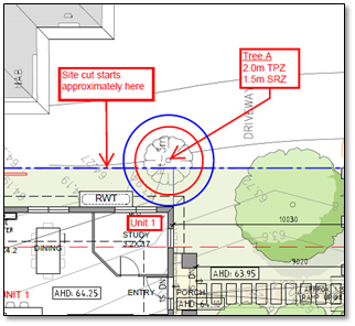
C Has made this decision having particular
regard to the requirements of Sections 58, 59, 60 and 61 of the Planning and
Environment Act 1987.
Carried
Unanimously
|
MELWAYS REFERENCE 47 A7
|
Applicant: Jesse
Ant Architects
Zoning: General
Residential Zone Schedule 4 (GRZ4)
Overlays: Significant
Landscape Overlay Schedule 9 (SLO9)
Special
Building Overlay (SBO)
Relevant Clauses:
Clause 11 Settlement
Clause 12 Environment
and Landscape Values
Clause 15 Built
Environment and Heritage
Clause 21.05 Environment
Clause 21.06 Housing
Clause 22.03 Residential
Development
Clause 22.04 Tree
Conservation
Clause 32.08 General
Residential Zone Schedule 4
Clause 42.03 Significant
Landscape Overlay Schedule 9
Clause 44.05 Special
Building Overlay
Clause 52.06 Car
Parking
Clause 55 Two
or More Dwellings on a Lot or Residential Buildings
Clause 65 Decision
Guidelines
Ward: Elgar
|
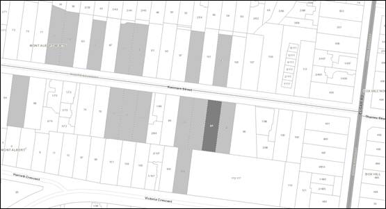
|
|
|
|
|
|
|
|
|
|
Subject site
|
|
15 Objector Properties
|
é
North
|
|
|
|
|
|
|
|
BACKGROUND
History
No previous Planning Permit
Applications have been made for this site.
The Site and Surrounds
The subject site is located on the
south side of Kenmare Street, 140 metres west of the intersection with Elgar
Road. The site is rectangular in shape with a frontage of 15.24 metres, a depth
of 56.3 metres and comprises an overall area of 859m2.
The site contains a single storey
weatherboard dwelling with a vehicle crossover and driveway located adjacent to
the east boundary. The site has a slope of approximately 2.5 metres falling
from the south-west (rear) to the north-east (front). No easements are
located on site.
The arborist report, prepared by
Bluegum Arboriculture, provides an assessment of 18 trees of
which Trees 2 to 14 are located within the subject site. Trees numbered
2, 3, 4, 6, 7, 8, 9, 11 and 13 are protected under the Significant Landscape
Overlay, Schedule 9. The trees are a mix of Pittosporum eugenoides,
Fraxinus angustifolia, Pittosporum undulatum, Arbutus unedo and Cotonesater
glucophylla species and assessed as being of ‘low’ arboricultural
retention value.
The trees on adjoining lots that are
protected under the SLO9 include Tree 15 (Syzygium smithii) and Tree 17
(Liquidamber styraciflua), both within the adjoining lot to the east.
The adjoining lot to the east, at 94
Kenmare Street, accommodates a single storey weatherboard dwelling. The
dwelling is setback 10.9 metres from Kenmare Street and 1.76 metres from the
common boundary with the site. The adjoining lot to the west, at 90
Kenmare Street, accommodates a single storey weatherboard dwelling setback 10.6
metres and 2.9 metres from the common boundary. Both dwellings are set within
established gardens. The lot to the east is lower than the subject site
and designated as floodprone by the Special Building Overlay (identifies overland
flows of water during heavy rain events). A car park serving Box Hill TAFE
abuts the south (rear) boundary.
In the vicinity of the subject
site, Kenmare Street comprises predominantly single storey older style detached
dwellings interspersed with some in-fill medium density residential
development. Of note, recent approvals include No. 93 Kenmare Street to the
north-west of the subject site, which has a Planning Permit (WH/2017/771) for
two double storey dwellings (one with basement), and No. 113 Kenmare Street (to
the north-east) also has a Permit (WH/2017/551) for two double storey
dwellings. In 2018, VCAT approved seven attached dwellings above a common
basement at 46 Kenmare Street located to the west of the subject site
(WH/2016/708). No. 73-77 Kenmare Street (to the north-west) has recently
had Planning Permit WH/2018/408 issue allowing nine double storey dwellings.
Planning Controls
The proposal triggers the need for a
Planning Permit under the following clauses of the Whitehorse Planning Scheme:
General Residential Zone Schedule
4
Pursuant to Clause 32.08-6 a permit
is required for the construction of two or more dwellings on a lot.
Under Clause 32.08-4 a development
must meet a minimum garden requirement of 35% (given the site area). The
development plans indicate an area of 301.3m2 or 35.06%.
Significant Landscape Overlay
Schedule 9
Under Clause 42.03-2 a permit is
required for the removal of protected trees and buildings and/or works within 4
metres of protected trees as summarised in the table below:
|
Tree No.
|
Botanical Name
|
Common Name
|
Height
|
Condition
|
Trigger under SLO9
|
|
2
|
Pittosporum eugenoides
|
Verigated Pittosporum
|
5m
|
Mature
Low value
|
Removal
|
|
3
|
Fraxinus angustifolia
|
Narrow-leafed Ash
|
8m
|
Environmental weed
|
Removal
|
|
4
|
Pittosporum undulatum
|
Sweet Pittosporum
|
5m
|
Environmental weed
|
Removal
|
|
6
|
Arbutus unedo
|
Strawberry Tree
|
7m
|
Mature
Low value
|
Removal
|
|
7
|
Prunus cerasifera
|
Purple Cherry Plum
|
5m
|
Environmental weed
|
Removal
|
|
8
|
Acer negundo
|
Box Elder
|
9m
|
Mature
Low-Moderate value
|
Removal
|
|
9
|
Cotoneaster glucophylla
|
Cotoneaster
|
5m
|
Environmental weed
|
Removal
|
|
11
|
Fraxinus angustifolia
|
Narrow-leafed Ash
|
6m
|
Environmental weed
|
Removal
|
|
13
|
Pittosporum undulatum
|
Sweet Pittosporum
|
7m
|
Environmental weed
|
Removal
|
|
15
|
Syzygium smithii
|
Lilly Pilly
|
11m
|
Mature
Moderate value
|
Buildings and works within 4m
|
|
17
|
Liquidambar styraciflua
|
Liquidambar
|
12m
|
Mature
Moderate value
|
Buildings and works within TPZ
(>4m)
|
Special Building Overlay
The Special Building Overlay affects
the south-east corner of the site. Pursuant to Clause 44.05-2 a permit is
required for buildings and works.
PROPOSAL
The application proposes to construct
three new double storey dwellings over a common basement car park
comprising:
· Relocation
of the existing single crossover westwards by 2 metres.
· Provision
of a shared basement level accessed via a single width accessway with a slight
hump at the entrance and a concrete retaining wall up to 1.2 metres high to the
east of the accessway to prevent flooding. This level provides for a
double garage to each dwelling, a theatre room for Dwelling 1 and a gym for
Dwelling 3, plus storage areas and a stair to the ground level for each
dwelling.
· The
front door to Dwelling 1 faces Kenmare Street, and the front doors to Dwellings
2 and 3 are accessed from a pedestrian path that runs along the east boundary.
· A
1.2 metre high steel picket and rendered brick pier front fence is setback 2.2
metres from the Kenmare Street frontage and contains pedestrian gates with
intercoms serving the dwellings.
· The
ground levels of each of the dwellings comprise kitchen, dining and living
areas and a master bedroom. The upper levels of each dwelling include
three further bedrooms and a retreat area.
· The
secluded private open space areas of the dwellings are located adjacent to the
east
· External
materials comprise face brickwork at ground level, light grey render at first
floor level, and tile cladding to the hipped roof forms.
· The
proposed dwellings have the following boundary setbacks:
o North (Kenmare Street
frontage):
§ 10 metres at ground level
§ Minimum 11.3 metres at upper
level
o East (side):
§ 2.5 metres at ground level
§ 3.5 - 4 metres at upper level
o West (side):
§ 1.4 - 7 metres at ground
level
§ 2.7 - 7 metres at upper level
o South (rear):
§ 1.5 metres at ground level
§ 3.3 metres at upper level
· The
upper levels of Dwellings 1 and 2 are separated by 3.6 metres and a minimum 3.7
metres is provided between Dwellings 2 and 3.
· Finished
floor levels for Dwelling 1 are elevated at the front of the site, and as the
land slopes up gently from Kenmare Street, Dwellings 2 and 3 are cut slightly
into the natural ground level (NGL) towards the rear of the land. At the
front of the site, Dwelling 1 is raised up to 0.6 metres above natural ground
level (NGL) and has a maximum wall height of 8 metres, and a maximum building
height (to top of roof) of 8.8 metres. At the rear of the site, Dwelling
3 is cut 0.8 metres into the NGL, giving a maximum wall height for Dwelling 3
of 6.6 metres.
· Overall
site (building) coverage of 47.3% and permeable area of 34.9%.
· All
trees are proposed to be removed from the site, comprising nine protected trees
(as per the table above) and three smaller trees (Tree No.s 5, 10 and 14) and
are under 5 metres high and not protected by the SLO9.
· The
landscape plan proposes:
o One 12 metre high tree
and six 8 metre high trees within the front setback.
o Three 8 metre high trees
planted in ground clear of the basement within the secluded private open space
of Dwelling 2.
o Two 10 metre high trees
within the secluded private open space of Dwelling 3.
CONSULTATION
Public Notice
The application was originally
advertised by mail to the adjacent and nearby property owners and occupiers and
by erecting a notice to the site frontage. Following this first
advertising period, 15 objections were received raising the following concerns:
· Amenity
impacts:
o Overlooking
o Overshadowing
o Loss of air quality
· Neighbourhood
Character:
o Building bulk and form
not in keeping with predominantly single storey area.
o Site cut for basement
out of keeping with the streetscape.
o Three storeys is too
high.
o Insufficient dwelling
separation.
o Too many dwellings.
o 2 metre high fence
topped with lattice should taper in the frontage to allow for driver sight
lines
· Car
parking and traffic:
o Increased on-street
parking.
o Increased traffic in an
already busy street. The nearby Buddhist Temple exacerbates parking
problems during Temple functions.
o Traffic safety impacts
on the street, exacerbated by the nearby crest.
o Increased vehicle
movements on site adjacent to neighbouring dwellings.
· Landscaping:
o Excessive tree removal
o Insufficient replacement
trees and understorey plantings
o Insufficient landscape
and permeable areas to support trees and open space.
· Environmentally
Sustainable Development:
o Additional dwellings,
reflected heat, air conditioners, increased utility usage and fewer trees and
gardens.
· Planning
Controls:
o Site cut for basement
may exacerbate flooding in the area
· Drafting
Errors:
o No. 107 Kenmare is
single storey, not double storey as shown on plans.
Melbourne Water provided an objection
in writing when referred the original application, and subsequently required
significant alterations to the original proposal in order to prevent flooding
of the (then) proposed development. The applicant subsequently redesigned the
development to address Melbourne Water’s concerns. The amended
plans include higher finished floor levels to prevent flooding, increasing the
overall height of the proposed dwellings and alterations to the proposed
boundary setbacks. The amended plans were readvertised and a further
seven submissions were received, all from original objectors, raising the
following additional issues:
· Concerns
regarding the extent of excavation required for the basement.
· Loss
of views
· Visual
and overshadowing impacts associated with the increased building heights
· More
hard surface areas due to the basement, and insufficient tree planting
· Proposed
fill could cause increased flooding to other land
· Insufficient
parking areas
It is also noted that Melbourne
Water withdrew their objection, and provided support to the amended proposal,
subject to conditions being imposed on any permit issued. The original
objections and the submissions made in relation to the amended plans are all
required to be considered with this application, and will be discussed below.
Consultation Forum
A Consultation Forum was held on 25
July 2019. Five objectors, the land owner, two representatives from the
applicant and two planning officers attended the meeting which was chaired by
Ward Councillor Liu.
The Forum followed an issues-based
discussion expanding on the concerns raised in the objections received.
Key points included:
· The
existing traffic and parking situation on Kenmare Street, including photos of
weekend on-street parking being tabled by an objector for consideration by
Council’s Transport Engineers.
· Overshadowing
of adjacent dwellings.
· The
need to screen overlooking, in particular from the Dwelling 2 retreat west
elevation window which faces the covered deck of the neighbour to the west,
which is an area sensitive to privacy impacts.
There were no further amendments
provided in response to the issues raised at the consultation forum.
Referrals
External
Melbourne Water
No objection to the plans currently
before Council for consideration, subject to conditions specifying minimum
finished floor levels
Internal
Engineering and Environmental Services
Department
· Transport
Engineer
The application has been reviewed by Council’s
Engineering Transport Team, who have required updates to plans to demonstrate
compliant vehicle access, which will be discussed in detail below.
· Waste
Engineer
An amended Waste Management Plan is required in response to
the amended plans, and will be required as a condition of Permit.
· Assets
Engineer
Consent subject to standard conditions
Planning Arborist
There are no trees on site worthy of retention. Removal and
replacement will provide the best outcome long-term. Therefore, it is
recommended a mix of indigenous, native and exotic trees are planted on the
site, and a list of recommended species has been provided. One additional
tree (identified as Tree A) located on the adjoining lot to the west must be
protected during the construction process. Subject to adherence to tree
protection conditions, the proposed development will not result in unacceptable
impacts to trees.
Parkswide Arborist
The street tree (Tree 1) is an immature Lophostemon
confertus (Queensland Brush Box) located within the road reserve. This tree
exhibits good health and structure with a long useful life expectancy. The
plans provided indicate that the proposed development will be outside of the 2
metre TPZ of this tree. This tree is unlikely to be impacted by the proposed
development. Tree protection measures are required to protect the tree during
the construction process.
ESD Advisor
A Sustainable Design Assessment was submitted with the
original plans, and an amended Sustainable Design Assessment is required to be
submitted in response to the amended plans that added the basement car park.
DISCUSSION
Consistency with State and Local
Planning Policies
The proposed
development is consistent with State and Local Planning Policies which seek to
ensure that housing stock matches changing demand by widening housing choice,
encouraging the development of well-designed housing that responds to the
preferred and prevailing neighbourhood and landscape character.
Clause 21.06 (Housing) of the Local
Planning Policy Framework is informed by Council’s Housing Strategy 2014,
and identifies the site within a Natural Change Area. Natural Change
Areas support increase housing choice by allowing for a diversity of dwelling
types, sizes and tenures and seek to ensure that new development contributes to
the preferred neighbourhood character of the precinct.
Clause 22.03, the Whitehorse
Residential Development Policy, applies to all applications for development
within the residential zones. The policy is used to supplement the
neighbourhood character and residential policy requirements of Clause 55. The
relevant objectives of Clause 22.03 are as follows:
· To
ensure that residential development within the City of Whitehorse is consistent
with the built form envisaged for the relevant category of housing change.
· To
ensure development contributes to the preferred neighbourhood character where
specified.
· To
ensure that new development minimises the loss of trees and vegetation.
· To
ensure that new development provides adequate vegetation and gardens consistent
with the preferred neighbourhood character.
The Neighbourhood Character Study
2014 further defines the preferred future character of precincts within the
City.
The preferred character statements
for each character precinct are defined under Clause 22.03-5. The subject site
is located within the Garden Suburban Precinct 8. The preferred character
statement for the Garden Suburban Precinct, 8 is as follows:
A variety of well-articulated dwelling styles will sit
within open garden settings incorporating a mixture of native and exotic
vegetation and large trees. The established pattern of front and side setbacks
will be maintained, allowing sufficient space for planting and growth of new
vegetation. Infill development will be common, however new buildings and
additions will be setback at upper levels to minimise dominance in the
streetscape.
Properties abutting and close to the Koonung Creek, Bushy
Creek and Gawler Chain parklands will contribute to the bushy landscape
character of the public realm, incorporating large native/indigenous canopy
trees and native/indigenous vegetation. The openness and informality of the
streetscape will be further enhanced by low open style front fences that allow
for views into front gardens.
The Neighbourhood Character Study
2014 document builds on this statement with specific Garden Suburban
Precinct 8 Guidelines, which are reflected in the variations to Clause 55 that
are set out in the applicable Schedule 4 to the General Residential Zone.
The design and siting of the proposed
development is consistent with the objectives and intent of Council’s
Residential Development Policy for developments within Natural
Change and the Garden Suburban Precinct 8 areas. The site’s
proximity to a number of community and commercial facilities, including
proximity to the Box Hill Activity Centre, lends weight to a more compact
design and siting outcome.
Design and Built Form
The Precinct
Guidelines encourage the provision of a single vehicle crossover as a means of
minimising car accommodation visible to the streetscape. The development
relies on a single crossover, ramped driveway and garages at basement
level. This removes the visual impact of car accommodation from the
streetscape and provides opportunity for an open front garden setting.
The three proposed
dwellings are sited in a tandem arrangement over the basement. The
basement is setback from side boundaries and contained largely below the
footprints of the dwellings and as such allows for in-ground landscaping around
the perimeter of the dwellings. The dwellings are separated by 1 metre
and 3.3 metres between the ground and upper levels respectively of Dwellings 1
and 2; and 2 metres and 3.7 metres between the ground and upper levels
respectively of Dwellings 2 and 3. These building breaks articulate the
presentation of the building form to the adjacent lots to the east and west and
break up the built form along the length of the site.
The upper levels of
the proposed dwellings are well-articulated mostly setback from the ground
level footprint, achieving an appropriate level of recession and articulation
at upper levels to minimise perception of visual bulk. The use of light weight
render to clad the upper levels provides a contrasting material to the ground
level face brick, and the provision of windows and eaves to upper floor
elevations adds further articulation and visual interest to the dwellings and
is respectful of the surrounding neighbourhood character.
The dwellings are
slightly cut into the slope of the land along the west elevation (by up to 0.8
metre) which will assist in keeping the overall building height down and
providing good transitions to the adjacent single storey dwellings.
Standard B6, as
varied by Schedule 4 of the General Residential Zone, requires, ‘any new
wall on a boundary should be setback at least 12 metres from the front boundary
or 3 metre further than the average set back of the buildings on adjoining
allotments, whichever is the lesser’. The development does not rely
on boundary wall development, with a minimum setback of 1.2 metres achieved to
the west boundary. The front setback achieves a minimum of 10 metres
which exceeds the requirements of Standard B6. This generous setback
allows for new tree planting and landscaping within the front setback to allow
for the development to integrate into a garden suburban setting.
The proposed
development provides for a minimum setback of 1.4 metres to the west side
boundary and 2.5 metres to the east side boundary at ground level. The
first floor level offers setbacks of between 2.7 and 7.1 metres to the west
boundary and between 3.5 and 4.0 metres to the east boundary. Both side
setbacks offer views to the rear of the site, and both provide opportunities
for in-ground landscaping clear of the basement below. The west boundary
setback also accommodates the secluded private open spaces for the three
dwellings and provides deep root planting areas within these spaces to
accommodate trees.
Standard B17, as
varied by the schedule to the zone, requires ‘any building, not on a
boundary, to be setback 3 metres from the side boundary, plus 0.3 metres for
every metre of height over 3.6 metres up to 6.9 metres’.The proposed
boundary setbacks are not fully compliant with this standard,however, in the
vicinity of the subject site, most lots provide garages or carports, usually
constructed to the boundary line, along one side, and a narrow (approximately
1.2 metre wide) setback to the other side boundary, with the result that the
immediate neighbourhood character in the vicinity of the subject site is more
reliant on front setbacks to contribute to landscape character than side
setbacks.
On balance, the
proposed side boundary setbacks are considered appropriate as they minimise
amenity impacts through avoiding any placement of walls on boundaries, and
achieve clear, landscaped areas along both side boundaries that exceed the
typical side boundary setbacks found in the vicinity of the subject site.
The secluded private
open space areas for each dwelling are provided along the west boundary and
each achieve a minimum dimension of 5 metres and a minimum area of 35m2
in compliance with Standard B28, as varied by Schedule 4 to the General
Residential Zone. The secluded private open space areas of Dwellings 1
and 2 are located opposite a verandah on the adjacent dwelling to the west
which is used as an outdoor living area. The co-location of sensitive
open space areas is considered to be beneficial to share the amenity of open
spaces of adjacent dwellings.
Whilst a portion of
the secluded private open space areas serving Dwellings 1 and 3 will be
overshadowed by the adjacent dwellings, the solar access to open spaces is
compliant with the requirements of Standard B21 of Clause 55, ensuring these
areas receive sufficient solar access.
The proposed site
coverage of 47% is under the 50% maximum set by Standard B8, as varied by the
schedule to the zone. The need for flood mitigation measures has required
the basement design and the resulting permeable area of 34.9% to marginally
exceed the 30% required by the varied Standard B9. However it is noted
that there are ample in-ground planting areas to support in excess of the six 8
metre high trees required by the varied Standard B17, and as such the proposed
permeable area is acceptable.
The proposed front
fence is 1.2 metres high, consistent with the varied Standard B32 of Clause 55,
and the open steel picket construction will provide for views into the landscaped
front setback.
Landscaping
Clause 21.05 (Environment), Clause
22.04 (Tree Conservation) and Clause 42.03 (Significant Landscape Overlay
Schedule 9) identify trees as being an integral aspect of an existing and
preferred character. The Statement of Nature and key elements of
landscape under the SLO9 recognises:
· Trees
are significant to the landscape character of Whitehorse and the tree cover
simultaneously delivers multiple benefits to the community, including defining
neighbourhood character, providing visual amenity, reducing the urban heat
island effect in more urbanised areas, improving air quality and energy
efficiency, providing habitat for fauna, increasing the wellbeing of people and
liveability of neighbourhoods.
The Overlay includes the
objective, ‘to encourage the retention of established and mature trees
and to provide for the planting of new canopy trees’.
1.
Within the Decision Guidelines of Clause 42.03, policy requires
consideration to be given to ‘the need to retain trees that are
significant due to their species, health and/or growth characteristics’,
while further outlining, ‘If retention cannot be achieved, or a tree
is considered appropriate for removal, consider whether the site provides
adequate space for offset planting of indigenous or native trees that can grow
to a mature height similar to the mature height of the tree to be
removed’.
Whilst Council’s Planning
Arborist has no objection to the proposed removal of the existing trees on
site, it is considered that a number of trees within the front setback that are
proposed for removal could be retained in association with the proposed
development. In particular, Tree 3 on the east beside the accessway is a
healthy 8 metre high tree that is unlikely to be affected by the excavation for
the basement accessway and could be retained to provide upper canopy
landscaping in the street frontage. In addition, the western portion of
the mature 5 metre high hedge of Variegated Pittosporum (Tree 2 -Pittosporum
undulatum) along the front boundary of the site could also be retained as
it will be clear of the works area, and would maintain a strong landscape
element within the Garden Suburban streetscape.
Subsequent to the Forum, the
applicants submitted an updated landscape plan reflecting the amended site
layout. The landscape plan provides for a hedge of 3 metre high shrubs
beside the pedestrian path along the east boundary, which will require
amendment to reflect the retention of Tree 3.
Six trees over 8 metres in height are
proposed to be located along the west boundary and within the front setback,
including one Robininia pseudoacacia (12 metre high Golden Robinia) in
the frontage. A proposed Crepe Myrtle (Lagerstroemeia ‘Biloxi’)
in the frontage will require removal in order to allow for the retention of the
front hedge (Tree 2). The landscape plan also proposes a row of five
closely planted Capital Pears (Pyrus ‘Capital’) beside the
accessway in the frontage, and it is recommended that this dense planting, within
2 metres of Dwelling 1, is reconsidered in order to provide for the mature
growth of trees.
All of the trees proposed to be
planted are exotic species, which does not comply with the preferred mix of
indigenous and exotic species for the Garden Suburban Area 8, and a condition
will require the replacement of some exotic trees with indigenous
species. Subject to the above changes, the submitted landscape plan will
provide a complete garden scheme that will enhance the Garden Suburban character
of the area.
Council’s ParksWide Team have
assessed the impact to the street tree. The street tree is an immature Lophostemon
confertus (Queensland Brush Box). The plans provided indicate that
the proposed development will be outside of the TPZ of this tree. This tree is
unlikely to be impacted by the proposed development.
Car Parking
The application has been reviewed by
Council’s Engineering Transport Team, who have in general supported the
proposal on traffic and car parking grounds. Where there are minor areas of
concern, the Transport team have required that conditions be imposed on any
permit issued.
It is noted that increased vehicle
movements and on-street parking were significant concerns raised by
objectors. Existing pressures on on-street parking were communicated to
Council’s Transport Engineers over the course of this application, and
consideration of these has been made by the Engineers in concluding that the
additional traffic can be absorbed by the local street network.
Amenity
The side boundary setbacks are
respectful of the adjacent dwellings to the west and west. To the west,
the adjacent dwelling is setback from the common boundary 2.9 metres behind a
driveway that serves a carport built to the common boundary. Dwellings 1
and 2 are setback 5 - 7 metres from the west boundary at the ground level
opposite a verandah on the adjacent dwelling, which is understood to be used as
an outdoor living area. Landscaping within the open spaces on the subject site
(for dwellings 1 and 2) opposite the neighbouring verandah will replace
vegetation in this location that is proposed to be removed, and will provide
additional privacy and visual screening between the two lots.
At the east boundary interface, the
adjacent dwelling is setback 1.8 metres from the common boundary. The proposed
minimum 2.5 metre setback of the development on the subject site at the ground
level will allow for the provision of a landscaped boundary interface and
provides sufficient setback from the TPZ of the 12 metre high Liquidambar (Tree
17) to the rear of the adjacent dwelling.
The proposed plans demonstrate that
overlooking from upper level habitable room windows to the adjoining
residential lots to the east and west will be mostly screened by the use of
highlight windows or fixed opaque glazing up to 1.7 metres above finished floor
levels, in accordance with Standard B22 of Clause 55. However The
Dwelling 2 retreat window on the west elevation will have views of the verandah
used as an outdoor living area for the adjacent dwelling, and as such this
window also requires screening, which will be included as a condition.
At the ground level, overlooking is
protected by a proposed 2 metre fence topped with 0.5 metre high lattice on the
east elevation, and a new 1.8 metre high fence on the west elevation. A
condition will require the height of these side boundary fences to be tapered
to 1.2 metres high, forward of Dwelling 1, in order to maintain an open
landscape frontage consistent with the preferred streetscape character.
The submitted Shadow diagrams
demonstrate that the development will result in an increase in overshadowing
from existing conditions to the adjacent residential lots to the east and west
between 9am and 3pm at the Equinox. This is well within the allowance of
Standard B21. In particular, morning shadows to habitable room windows of
the adjacent dwelling to the west that were raised in an objection will be
clear of these windows by 10am, allowing solar access to these windows through
the middle of the day.
There will be no unreasonable amenity
impacts to the adjacent property to the rear, as this is a TAFE car park that
does not require protection.
Environmentally Sustainable
Development
Whitehorse City Council is committed
to creating an environmentally sustainable city. Critical to achieving this
commitment is for development to meet appropriate environmental design
standards. The local policy at Clause 22.10 aims to integrate environmental
sustainability principles into land-use planning, new developments and
redevelopment of existing infrastructure.
A Sustainable Design Assessment was
submitted with the original plans and Council’s ESD Officer advised that
this was acceptable subject to conditions. The amendments however made to
plans in response to Melbourne Water’s concerns altered the proposed site
layout, and require an amended Sustainable Design Assessment, which will be
required as a condition of approval.
Melbourne Water Response
The south-east corner of the subject
site and the land adjacent to the site to the east are affected by the Special
Building Overlay. This Overlay identifies areas that can experience
overland flows of flood waters in heavy rain events. The spread of the
overlay and the topography of the area indicate that any floods will flow
northwards over the lower-lying land to the east of the subject site, flowing
towards Hagenauer Reserve.
Melbourne Water’s original
objection and the conditions provided for the current proposal have been
required primarily to prevent the flooding of the subject site and to allow the
free flow of flood waters to the east of the site. Specifically, minimum
finished floor levels are specified for the proposed dwellings to ensure they
are above the 1 in 100 year flood level, and the basement accessway is required
to ramp up at the entrance to prevent flood waters entering the basement.
Fences, decks and verandahs are required to be constructed so they do not
obstruct the flow of floodwaters.
Standard asset conditions will be
imposed to ensure that the subject site does not discharge water onto adjoining
lots.
Objectors Concerns not Previously
Addressed
· Increased
vehicle movements on site adjacent to neighbouring dwellings.
The provision of a basement car park will contain vehicle
noise and protect the acoustic amenity of adjacent dwellings.
· Concerns
regarding the extent of excavation required for the basement.
Protection of adjoining properties during construction is
dealt with under the Building Permit process.
· Loss
of views
Views are not protected by the Planning Scheme.
CONCLUSION
The proposal for construction of
three double storey dwellings with basement garages and associated tree removal
is an acceptable response that satisfies the relevant provisions contained
within the Whitehorse Planning Scheme, including the State and Local Planning
Policies, the General Residential Zone Schedule 4, Significant Landscape
Overlay Schedule 9, Special Building Overlay and Clause 55. The proposed
development form, siting and overall design is considered to be acceptable and
will integrate with the existing built form and landscape character of Kenmare
Street.
A total of 15 objections were
received as a result of public notice and all of the issues raised have been
discussed as required.
It is considered that the application
should be approved.
Attachment
1 Plans ⇨ 
Ordinary Council Minutes 16
September 2019
Strategic
Planning
9.1.4 Amendment
C219: Permanent Significant Landscape Overlay, Schedule 9, Review of
Submissions
FILE
NUMBER: SF19/366
ATTACHMENT
SUMMARY
Amendment C219 proposes to apply the
Significant Landscape Overlay (SLO), Schedule 9 on a permanent basis to all
residential land that does not already have a permanent SLO in place. In
addition, the amendment makes consequential changes to local clauses in the
Whitehorse Planning Scheme. An interim SLO9 remains in place to protect trees
in the affected areas while Council progresses the amendment for the permanent
SLO9 under Amendment C219 through the usual amendment process, involving public
exhibition and review of submissions.
The amendment was on public exhibition
from 18 July until 19 August 2019. A total of 307 submissions were received to
the Amendment (303 submissions were received during the exhibition period and
four (4) late submissions were received after the exhibition period).
This report discusses the issues raised in
submissions received and recommends that the Amendment and all of the
submissions (including late and supporting submissions) be referred to an
independent Planning Panel for consideration.
|
Motion
Moved by Cr Massoud,
Seconded by Cr Cutts
That Council:
1. Being the Planning Authority, having
considered all submissions under Section 22 of the Planning and Environment
Act 1987 in relation to Amendment C219, request the Minister for Planning
appoint an Independent Planning Panel to consider the Amendment and all of
the submissions in Attachment 1 in accordance with Section 23 of the Planning
and Environment Act 1987.
2. Make the following changes to Amendment C219:
a) Amend
Schedule 9 to Clause 42.03 to italicise botanical names of environmental weed
species.
b) Amend
the exemption relating to the Environmental Weeds list in sub-clause 3.0 of
Schedule 9 to Clause 42.03 to read “A tree that is listed as an
Environmental Weed species listed below”.
c) Amend
the exemption relating to swimming pools in sub-clause 3.0 of Schedule 9 to
Clause 42.03 to read: “A tree that is located less than 3 metres from
an existing in-ground swimming pool when measured at ground level from the
outside of the trunk”.
d) Include
an additional planning permit exemption in sub-clause 3.0 of Schedule 9 to
Clause 42.03: "The removal, destruction or lopping of a tree to the
minimum extent necessary to maintain the safe and efficient function of the
existing on-road public transport network (including tramways) to the
satisfaction of the Department of Transport".
e) Include
reference to the tree canopy target of 30% contained in Council’s Urban
Forest Strategy in Clause 21.05 (Environment) of the planning scheme.
3. Review the local VicSmart provisions as they
relate to applications for tree removal and works within 4 metres of a tree.
4. Advise all submitters of the request for an
Independent Planning Panel.t
|
|
Amendment
Moved by Cr
Davenport
That Council:
1. Being the Planning Authority, having
considered all submissions under Section 22 of the Planning and Environment
Act 1987 in relation to Amendment C219, request the Minister for Planning
appoint an Independent Planning Panel to consider the Amendment and all of
the submissions in Attachment 1 in accordance with Section 23 of the Planning
and Environment Act 1987.
2. Make the following changes to Amendment C219:
a) Amend
Schedule 9 to Clause 42.03 to italicise botanical names of environmental weed
species.
b) Amend
the exemption relating to the Environmental Weeds list in sub-clause 3.0 of
Schedule 9 to Clause 42.03 to read “A tree that is listed as an
Environmental Weed species listed below”.
c) Amend
the exemption relating to swimming pools in sub-clause 3.0 of Schedule 9 to
Clause 42.03 to read: “A tree that is located less than 3 metres from
an existing in-ground swimming pool when measured at ground level from the
outside of the trunk”.
d) Include
an additional planning permit exemption in sub-clause 3.0 of Schedule 9 to
Clause 42.03: "The removal, destruction or lopping of a tree to the
minimum extent necessary to maintain the safe and efficient function of the
existing on-road public transport network (including tramways) to the
satisfaction of the Department of Transport".
e) Include
reference to the tree canopy target of 30% contained in Council’s Urban
Forest Strategy in Clause 21.05 (Environment) of the planning scheme.
f) Introduce an exemption for an arborist report for removal of a
tree for the construction of a Dependent Person Unit.
3. Review the local VicSmart provisions as they
relate to applications for tree removal and works within 4 metres of a tree.
4. Advise all submitters
of the request for an Independent Planning Panel
The Amendment lapsed for want of a seconder
|
|
The
motion moved by Cr Massoud, Seconded by Cr Cutts was then put and CARRIED
UNANIMOUSLY
|
background
On 26 May 2017 Council submitted a
request to the Minister for Planning (the Minister) to approve Amendment C191
to the Whitehorse Planning Scheme (Planning Scheme) to apply the Significant
Landscape Overlay (SLO) on an interim basis to all residential land that does
not already have permanent tree protection controls in place. Council also
sought authorisation to prepare and exhibit Amendment C196 to apply the same
controls on a permanent basis having adopted the Municipal Wide Tree Study
Options and Recommendations Report, June 2016 at its meeting on 18 Jul
2016.
On 28 December 2017 the Minister
approved Amendment C191, which came into effect on 8 February 2018 introducing
Schedule 9 to the SLO on an interim basis until 31 December 2018. The Minister
refused Council’s request to prepare and exhibit Amendment C196 and
directed Council to undertake further strategic work before submitting a new
request to apply the same controls on a permanent basis.
On 18 December 2018 the Minister
extended the lapse date for the interim SLO by 6 months until 30 June 2019
(Amendment C214). Council engaged planning consultants to assist in undertaking
the further strategic work, which included an assessment of the landscape
character of the municipality to demonstrate the significance of the areas
across which the proposed tree controls are proposed to apply. This work,
titled Municipal Wide Tree Study, Part 2: Additional Analysis in Garden
Suburban and Bush Suburban Character Precincts, March 2019 was adopted by
Council at its meeting on 18 March 2019.
On 3 April 2019 Council submitted a
new request to the Minister to prepare and exhibit Amendment C219 to
permanently apply SLO9. On 27 June 2019 Council received notice that the
Minister had authorised Council to prepare the amendment and it was
subsequently placed on exhibition from 15 July until 19 August 2019. On 28 June
2019 the lapse date for the interim SLO was extended via Amendment C223 by a
further 1 year to allow the completion of the amendment process for the permanent
controls.
What does Amendment C219 do?
The explanatory report states that Amendment C219:
· Amends
the planning scheme maps by applying the SLO Schedule 9 on a permanent basis
and deleting the Vegetation Protection Overlay (VPO) Schedule 2 and Schedule 4
· Amends
local planning policy Clause 21.05 (Environment) to:
o Strengthen references to
the importance of tree preservation and retention to the neighbourhood
character of Whitehorse in the policy basis and objectives
o Clarify the lot size and
tall tree strategies as applying in the SLO in the Bush Environment character
precincts.
· Amends
local planning policy Clause 22.04 (Tree Conservation) to:
o Strengthen references to
canopy trees and neighbourhood character in the policy basis and objectives
o Strengthen references in
the policy basis about tree retention to ensure that trees are retained if they
are also significant to neighbourhood character
o Strengthen references to
replanting to ensure that new trees are appropriate for the location, soil type
and neighbourhood character
o Refine the provisions
relating to buildings and works near existing trees to provide for a minimum
setback of 3 metres in SLO9 rather than the 4 metres that applies to SLO
schedules 1-8
o Refine the provisions
relating to tree regeneration to provide for a minimum area of 35m2
per tree in SLO9 rather than the 50m2 that applies to SLO1-8
o Reconfirm that when a
planning permit is triggered, an arborist report is required to justify the
removal of all trees, irrespective of the health of the tree
· Amends
Schedule 9 to Clause 42.03 (Significant Landscape Overlay) shown in Attachment
2 to:
o Apply the schedule on a
permanent basis by deleting the expiry date of the control
o Strengthen the landscape
character objective to include reference to replacement trees
o Introduce new exemptions
providing for the removal, destruction or lopping of a tree without a permit
for:
§ Trees located less than 3
metres from the [existing] wall of a dependent person’s unit or dwelling
§ Trees located less than 3
metres from an [existing] in-ground swimming pool
§ Specified environmental weeds
§ Trees affecting public
utilities including powerlines, services within easements and the like
§ Street trees in line with
Council’s Street Tree Policy
§ Trees required to be removed,
destroyed or lopped in order to construct or carry out buildings or works
approved by a Building Permit issued prior to 8 February 2018
§ Trees that may require
separate approval to remove, destroy or lop as part of an existing permit
condition, a plan endorsed under a planning permit or an agreement under
section 173 of the Planning and Environment Act 1987
· Lists
new background documents in Clauses 21.05, Clause 21.06, Clause 22.03 and
Clause 22.04 – Municipal Wide Tree Study Discussion Paper, March
2016, Municipal Wide Tree Study Options and Recommendations Report, June
2016 and Municipal Wide Tree Study Part 2: Additional Analysis in Garden
Suburban and Bush Suburban Character Precincts, March 2019
· Makes
reference to these documents in the decision guidelines under Schedule 9 to
Clause 42.03.
· Includes
an additional decision guideline in Schedule 9 to Clause 42.03 to require
Council to consider, as appropriate, the cumulative contribution the tree makes
with other vegetation in the landscape and the impact of incremental loss.
· Deletes
Schedule 2 and Schedule 4 to Clause 42.02 (VPO) from properties where they
currently apply.
DISCUSSION
Council received 307 submissions in
response to exhibition of Amendment C219.
Two submissions in support of the
Amendment were received after the exhibition period. One submission objecting
to the Amendment was received after the exhibition period. One submission was
received from the Environment Protection Authority (EPA) after the exhibition
period that did not offer any further comments. Under Section 22(2) of the Planning
and Environment Act 1987, the planning authority may consider a late
submission. It is proposed that Council accept the late submissions.
The response represents
approximately 0.4% of property owners and occupiers notified about the
Amendment.
Analysis of submissions
221 submissions were from
submitters located in Whitehorse. 53 submissions did not provide an address and
33 submissions were from addresses outside the City of Whitehorse.
Table 1 shows the submitters by
suburb. Of those submissions where the origin was known, 34 (15%) came from
Blackburn and 10% came equally from Forest Hill (21), Mitcham (22) and
Nunawading (22).
The table also compares the number
of submissions who provided outright support with all other submissions. Other
submissions include submissions which sought changes, submissions that objected
to the Amendment or those where the level of support or opposition to the
Amendment was unclear.
Table
1 – Submitters by suburb (supporting submissions plus all other
submissions)
The chart below shows that
approximately 26% provided outright support for the Amendment. Approximately
22% indicated they support, or may support the Amendment if changes are made.
Approximately 13% of submissions did not clearly specify if they provided
support or objection to the Amendment, but they expressed concern or put
forward changes.
Approximately 38% objected to the
Amendment outright.
Chart
1 – Breakdown of submissions
Submission themes
The submissions are discussed under
the following broad themes:
· Submissions
in support of the Amendment
· Trees
are a safety hazard to property and/or people
· Potential
fees and costs associated with planning permit applications
· Imposition
on private property rights
· Impact
on development in Whitehorse, including reduced housing capacity and
overshadowing of solar panels
· Changes
to the proposed control, primarily in relation to the list of proposed
exemptions and the space required for tree planting
· The
intent of applying the control to properties.
· Other
comments including tree removal by developers, the amendment process, street
trees and the resources required to manage tree removal applications.
Attachment 1 provides a summary of each submission
and a response. As many of the submissions included common issues, a broad
response to key issues raised is provided below:
1. Submissions
in support of the Amendment
There were a number of
submissions that provided support for the Amendment. Submitters who had
lived in Whitehorse for a long time stated their concern that they have
observed a decline in canopy tree coverage across time. Supporters also
expressed that trees are very important for the entire community. Canopy trees
contribute to the amenity of the urban environment and regulate the climate,
such as reducing the heat island affect in urban areas. Canopy trees regulate
air quality, provide habitat for fauna and provide shade for properties which
could assist in reducing reliance on artificial cooling of properties in
summer.
Submissions in support included
strong discussion about the need to protect mature trees and the value that
these trees add to the landscape and neighbourhood character of Whitehorse. It
was also noted by supporters that canopy trees take a number of years to mature
and replanting with new trees does not replicate the benefit of the original
tree; instead canopy trees should be retained in the first instance.
The submissions included the
following comments:
· “Concerned
about the loss of tree cover in the municipality”
· “Support
the recognition of the important role canopy tree vegetation has to the broader
community”
· “Very
important amendment to the planning laws that will help maintain all the
benefits trees provide to the neighbourhoods in Whitehorse”
· “Need
large trees and a complete range of vegetation levels to provide habitat and refuge
for birds and other wildlife”
· “Support
this amendment to preserve the leafy character of these suburbs”.
The submissions of support are
noted.
2. Trees
are a safety hazard to property and/or people:
Many submitters have expressed
their concerns about the potential safety hazards associated with trees,
including dropping of limbs, complete tree failure or dropping of leaves and
debris. Some submitters also raised concerns about damage to property such as
to drainage pipes.
It should be emphasised that
trees on private property are the responsibility of the private landowners and
the introduction of permanent tree protection controls such as the SLO does not
remove the responsibility of the land owner to maintain his/her property,
including trees, and to minimise any risk from the vegetation. A permit
exemption is provided for trees that are dead or dying, or are posing an
immediate danger (an arborist assessment may be required to determine the
health of a tree under this exemption). The issue of planning application
related exemptions and costs are discussed in further detail below.
Some submissions raised issues
around the liability of Council where a control was placed on trees that
necessitated a planning permit for removal. In Timbs v Shoalhaven City
Council [2004] the NSW Court of Appeal found that a council was
liable for failing to properly consider a request to remove trees that were
dangerous. The issue arose because a council employee, when asked if trees
could be removed, did not advise the homeowner to make an application, rather
he said that the trees could not be removed without permission (which was
true). If, however an application had been made, the trees had been competently
inspected and a decision made, in good faith, not to allow the removal of the
trees there would have been no liability even if the tree had fallen in the
wind. The case concluded that liability does not arise because of bad
consequences but because of a failure to take reasonable care.
There were several trees
mentioned in submissions that had, or were, causing concern for submitters. In
some instances these had been reported to Council who had inspected them for
any immediate hazard and concluded that they were healthy and safe or they
needed works undertaken. Until Council is made aware of a particular tree it cannot
advise or investigate if a tree is dead, dying or dangerous and whether it
should be removed on that basis, or whether it needs a planning permit
application with an assessment from an independent arborist.
3. Potential
fees / costs associated with planning permit applications
A planning application will be
required to remove, destroy or lop a tree that is of the size triggered by
SLO9. Many submitters opposed the cost of a planning permit application and/or
the cost of the arborist report required to be submitted with an application.
Some submitters stated that Council is using the proposed controls as a revenue
raising mechanism and that fees should be waived.
The Planning and Environment
(Fees) Regulations 2016 prescribe the fees to be paid to Council for
planning permit applications. The Regulations set fees in ‘fee
units’ which are adjusted each year by the State Treasurer. Part 20
of the Regulations outlines where Council may wholly or in part waive the
payment of a fee, which can include instances such as:
· If
the application is withdrawn and a new application is submitted in its place
· If
the application is of a minor nature
· The
requested service imposes no appreciable burden or a lesser burden than usual
for supplying the service
· The
application assists the proper development of the all, or part of, the State,
Region or municipal district
· The
application assists the preservation of buildings or places in the State,
Region or municipal district which are of historical or environmental interest
· The
application relates to land used exclusively for charitable reasons
Council is required to record in
writing each instance where it wholly or partly waives the payment of a fee
under the Regulations. It is considered that largely, none of these instances
apply to applications for tree removal under the proposed control. However
Council may consider a fee waiver for a church or another charitable
organisation.
If a permit is required for the
removal of one tree, it may be possible to obtain this through the VicSmart
application process, which fast tracks decisions on minor planning applications
in 10 business days. The fee for a VicSmart application is currently $199.90.
If multiple trees are proposed to be removed and the works are less than $100,000
the fee for a permit application is currently $1,147.80. Residents are
encouraged to contact Council’s Planning and Building Department if they
have questions about trees on their property and the planning permit
application process.
The Know your Council website
details the performance of councils for a range of services including the
direct cost to council of the statutory planning service across all planning
applications received. In 2017-2018, the average direct cost to Whitehorse City
Council of the statutory planning service per application was $2,573.96. For
similar councils the direct cost is $2,757.12 and for all metropolitan councils
the direct cost is $2,459.07. Therefore the fee of $199.90 for an application
to remove one tree (and the standard application fee if multiple trees are
proposed for removal) does not recoup the cost of resources required to assess
an application and is not being used as a revenue raising mechanism.
A Regulatory Impact Statement (May
2016) noted that the Victorian Government’s policy is that fees should be
set to recover the full cost, unless there are policy reasons to depart from
full cost recovery. A number of fees, including VicSmart permits for buildings
and works valued at less than $10,000, are set at less than full cost recovery.
A reduced fee is considered appropriate because “a large proportion of
permits in these categories likely reflects building and work carried out by
home owners and small business owners”. Additionally, “a high fee
relative to the value of works raises concerns in the areas of ability to
pay…and potential for non-compliance”. Given this, it is
unlikely that Council would waive the fees or offer a reduction in rates, as
requested by some submitters.
An arborist report is required under
Clause 59 of the Planning Scheme for a VicSmart planning application to remove
a tree in the SLO. The costs associated with obtaining an arborist report
concerns some submitters. The Panel for Planning Scheme Amendment C51 (to
implement the Whitehorse Neighbourhood Character Study 2003 and amended SLO
schedules) considered that it would be reasonable to ask a proponent to provide
an arborist report to Council at their cost where it is unclear if a tree meets
an exemption or if the tree is healthy and is proposed for removal for other
reasons (page 41 of the Panel Report for Amendment C51). With the interim SLO9
controls, Council has required the submission of arborist reports with
applications, which are then reviewed by Council’s consultant arborist.
The cost of an arborist report
will depend on the circumstances at hand. Officers have undertaken benchmarking
and identified that, depending on the number of trees to be assessed, the
approximate cost of an arborist report for one tree is $500 - $600, with additional
trees being charged at $25-$100 per tree. This would form a one-off cost
to the property owner. Figures greater than this may also have included works
to the trees.
A review of other Councils with
similar planning controls, shows that for applications for low numbers of
trees, Councils are often providing the arborist assessment at a subsidised
rate. The Statutory Planning team is currently reviewing what this process
might look like, with the aim to reduce the cost for applicants for VicSmart applications,
whereby Council would provide the arborist assessment at a subsidised rate.
It should also be noted that some
tree maintenance may fall under the ‘ornamental pruning’ and
‘pruning for regeneration’ clause, and therefore no permit or
arborist report will be required.
Finally, allowing the removal of
more than one tree per VicSmart application has been identified by the
Statutory Planning Unit as a provision that could be reviewed (due to the
lesser administrative burden of assessing a small number of trees). This could
be further investigated as a local VicSmart control which allows Councils to
specify types of applications that can be assessed through the VicSmart
application process. In undertaking this review, Council could also consider works
within 4 metres of a protected tree through the VicSmart process.
4. Imposition
on private property rights
Many submissions raised the issue
of Council imposing control over trees located on private property, often
planted by the residents themselves, and thereby intruding into decision making
on private land and requiring the property owner to follow externally
determined tree regulations.
The introduction of overlay
controls on private property is a valid planning measure where a special
feature of the land requires protection. Other similar planning controls
that Council has previously introduced include Schedules 1-8 of the SLO, the
Heritage Overlay (HO) and the permanent Vegetation Protection Overlay
(Schedules 1-5). The application of such overlays is consistent with the
overall objectives of the Planning and Environment Act 1987 which
includes providing for the protection of natural resources and the maintenance
of ecological processes and genetic diversity.
Concerns about community benefits
at the cost of individual rights is an issue often expressed when new planning
provisions are proposed, and in the case of tree protection controls, this
relates in part to the ongoing obligation to maintain the tree/s and the
associated costs. Through provision of appropriate planning information
and advice, Council can play an important role in alleviating landowner
concerns about the ability to manage trees on their property, and thereby help
minimise loss of significant vegetation in the municipality.
Tree preservation is important on
private land as well as public land to maintain a healthy urban forest canopy
cover across the municipality of 30% as a minimum. This target is contained in
the Urban Forest Strategy which was adopted by Council in 2018 and could
include this target in Clause 21.05 (Environment) to link this intention with
the planning scheme. The target is based on research which indicates that the
full benefits of an urban forest, including cooling of the urban areas, is
achieved when the canopy cover reaches 30%. Estimates of current canopy cover
may vary depending on the type of assessment tool used and the quality of data
involved. The interim report: Urban Vegetation Cover Analysis prepared
by the Department of Environment, Land, Water and Planning (DELWP) estimated
that almost 21% of Whitehorse was covered by tree canopy above 3 metres when it
was surveyed in 2014. The Discussion Paper (March 2016) prepared as part of the
Municipal Wide Tree Study determined that the tree canopy coverage was
between 22% – 26% of all land in the municipality in 2016.
Council’s Tree Study used software called ‘i-tree’ which did
not take tree height into consideration and therefore may have captured trees
less than 3 metres in height. This may account for the discrepancy between the
two estimates.
More recent data released by
DELWP in July 2019 for trees over 3 metres shows that the City of Whitehorse
currently has a canopy cover of approximately 18% which indicates a decline in
overall canopy coverage across the municipality of 3% in 3 years. Moreover, it
is evident that the number of canopy trees greater than 5 metres will likely be
less once trees between 3 – 5 metres in height are removed. However only
10% of the municipality is managed by Council and therefore mature trees on
both public and private land will need to contribute to the overall canopy
cover target of 30%.
5. Impact
on development
Some submitters are concerned
that the proposed tree protection controls will reduce development and/or
impact on housing development and affordability. SLO9 will not prohibit
subdivision or development. However, new development must address the tree
protection controls of the overlay, meaning that careful design and planning
will be necessary to make sure development allows for the continuation and good
health of the protected tree/s. The decision guidelines will guide
outcomes on the value of the tree/s and the contribution to the streetscape and
local habitat, and the consideration of options to enable retention of the
tree/s. Pre-application planning advice should be sought from
Council’s Statutory Planning Unit, prior to the commissioning of development
plans.
Some submissions raised concerns
about the impact of the controls on the housing capacity of Whitehorse.
Council’s Housing Strategy and Neighbourhood Character Study
2014 demonstrated that there is sufficient housing capacity in particular areas
of Whitehorse to justify more stringent controls to protect Whitehorse’s
valued neighbourhoods. This is consistent with the direction provided in Plan
Melbourne 2017 - 2050 and State and local planning policy.
As part of Council’s
submission to the Managing Residential Development Advisory Committee in 2016,
Council presented a broad analysis into its land and theoretical dwelling
supply based on its proposed new residential zones and other areas where
dwellings could be located (such as in commercial areas). The figures showed
that Whitehorse can satisfactorily accommodate the expected growth in housing
in the municipality to 2036 and beyond within its residential rezoning, as well
as protect environmentally sensitive and highly valued neighbourhood character
areas for the future. Council rejects any assertion that it is not
accommodating its fair share of residential growth. In summary, based on the
existing zoning regime, as at 2014:
· Whitehorse’s
housing requirement to 2036 is 12,997 dwellings (an average of 500 new
dwellings per year).
· Whitehorse’s
theoretical dwelling capacity is 108,755 dwellings.
· Whitehorse
theoretically has over eight times the dwelling capacity it requires to meet
its future housing needs (95,758 extra dwellings).
The figures do not take into
account the lifting of the two dwelling limit in the Neighbourhood Residential
Zone (which was in place when the zones were first introduced). Therefore the
theoretical limit would be higher based on the removal of this limit.
Additionally a permit for tree
removal is not proposed outside the minimum building setback in the Residential
Growth Zone in recognition that this zone is intended to provide for housing at
increased densities. This balances the protection of the neighbourhood character
and streetscape with the supply of land for future housing growth. This
exemption is not proposed for other zones as they are intended to be locations
of less intense growth and development.
Some submitters raised concerns
about the inability to remove trees that may affect existing, or future, solar
panels. It is recognised that factors such as tree type, height and density may
affect the extent of overshadowing to a rooftop solar energy facility whereby
efficiency and performance is affected. Amendment VC149 (gazetted on 24 July
2019) was aimed at addressing the issue of overshadowing to solar systems due
to new development and works. DELWP also prepared Planning Practice Note 88
– Planning considerations for existing residential rooftop solar energy
facilities and a Solar Overshadowing Information Brochure – Home Owners
Guide (October 2018) to mitigate and manage impacts. The effects on rooftop
solar energy facilities should be mitigated through taking into consideration,
but not limited to, the following:
· The
appropriate siting and location of the rooftop solar energy facility;
· The
extent to which the rooftop solar energy facility has been located to protect
it from overshadowing through placement higher on the roof;
· Whether
the rooftop solar energy facility is mobile and can be relocated to another
area of the roof;
· The
type of rooftop solar energy facility and transitioning to an alternative
system or incorporating system enhancements, e.g. a multiple string system is
less affected by shading than a single string system. Additionally, system
features such as micro inverters or bypass diodes assist to enable a system to
operate with partial shading;
· The
type of tree that is planted and whether appropriate consideration has been made,
taking into account growth potential such as tree height and crown extent;
· Whether
the tree can be appropriately trimmed and pruned without jeopardising the
health of the tree; and
· The
extent of overshadowing legitimately affecting the operation and efficiency of
the solar energy facility.
An express right to solar access
remains a contentious issue and has not been well articulated in the Victorian
planning system, particularly with respect to solar panels being granted access
to direct sunlight. VCAT has experienced several matters which raise this
concern in the context of development and overshadowing. John Gurry & Assoc
Pty Ltd v Moonee Valley CC & Ors (Red Dot) [2013] VCAT 1258 articulated
various factors to be treated as reference points when decision-makers take
into consideration potential overshadowing; noting however that each decision
must be treated on its own facts. Such factors can include:
· A
test of “reasonableness”, rather than avoiding overshadowing
altogether
· Whether
the strategic planning controls and policies affecting the land allow for
legitimate expectations for solar access
· Whether
relevant solar panels have been placed in an unreasonably vulnerable position
on the host building; and
· The
length of time the solar panels have been installed on the host building.
As such, overshadowing of solar
panels due to trees and whether to grant a permit for tree removal should draw
reference to the existing documentation and guidelines that DELWP have prepared
as well as other considerations and supporting evidence that emerges on a case
by case basis.
6. Changes
to the proposed control and/or permit exemptions
Several submissions proposed
changes to the controls and/or permit exemptions.
List of environmental weeds
Some submissions requested the
addition of a specific tree species to the exempted environmental weeds list.
Council’s Consulting Arborist, Tree Education Officer and Senior
Environmental Advisor reviewed all of the suggested species and agreed that
none of the suggested species warrant inclusion on the exemption list. The
species included Early Black Wattle, Poplars, Bay trees, all types of
Pittosporum, non-native trees, Moreton Bay fig, Gum trees, Liquid Amber,
Oleander, Lilly Pilly, Privet, Paperbarks, conifers and Pine Trees.
One submitter suggested that the
Environmental Weed list should say “comprised of” instead of
“including” as the word “including” is not definitive.
Legal advice about the interpretation of this exemption concluded that the word
“including” is not definitive and therefore does not list the
species to the exclusion of all others, as was the intention of the exemption.
It is proposed to clarify the words preceding the Environmental Weed list.
Tree height and trunk
circumference thresholds
Some submissions requested
changes to the height and girth at which a planning permit would be triggered.
A benchmarking exercise undertaken for the Municipal Tree Study has
shown that canopy trees become visible in the streetscape at 5 to 6 metres in
height and begin to contribute to the neighbourhood character and create a
relationship to the scale of buildings. Part 2 of the Municipal Tree Study
analysed the "and/or" requirement whereby either the height or
circumference or both trigger a planning permit. The Study concluded that the
triggers ensure that the control is targeting trees that are large enough to
have an impact on neighbourhood character or will become significant canopy
trees into the future. It is not recommended that the triggers be changed.
Some submissions queried how a
measurement can be taken when the tree has multiple trunks. The measurement is
of a single trunk circumference. Therefore if
a tree is multi-trunked, if the largest of those trunks meets the circumference
trigger than a permit would be required. If a tree has five trunks for example
and none of them is or greater than the circumference trigger, then a permit is
not required.
Proximity of trees to
dwellings and in-ground pools
Some submissions proposed changes
to the exemptions relating to the distance from a dwelling or in ground
swimming pool where the proposed permit exemption will apply to trees located
less than 3m from these assets. The exemption for trees within 3 metres of a
house aligns with provisions in Clause 22.04 of the Planning Scheme which also
recommends a minimum separation distance of 3 metres between trees and
buildings and works in SLO9 (4 metres in SLO 1-8 and VPO sites) to protect both
the root system and the building foundations. This distance is also consistent
with exemptions that apply for all of the SLOs in the City of Maroondah. Yarra
Ranges and Knox provide exemptions for trees within 2 metres of buildings,
which means that SLO9 is proposed to be more generous in this regard. This
distance also assists residents, developers and applicants on adequate
separation from buildings for new tree planting. It is not recommended that
this exemption be modified.
Further to the above, the
Amendment proposes to exempt the need for a planning permit to remove, destroy
or lop a tree within 3 metres from an in-ground swimming pool. The exemption
does not explicitly state that it applies to existing in-ground
swimming pools, which was the intention of the exemption. It is proposed to add
the word “existing” to the exemption relating to in-ground swimming
pools.
Space required for tree
planting
Some submissions requested
changes to the provision relating to the requirement for a minimum area of 35m2
for a tree in SLO9 rather than the provision of a minimum area of 50m2
as per the SLO1-8. The Tree Conservation Policy at Clause 22.04 refers to a
minimum planting area (to establish new trees) of 50m². These provisions
were intended to apply to the existing SLOs 1 - 8 due to the nature of the Bush
Environment Character areas covered by SLO1-8 and the larger native and
indigenous tree species preferred in these landscapes. The same tree planting
area is not appropriate for the areas proposed to be covered by SLO9 (Bush
Suburban and Garden Suburban Character areas) due to the prevailing lot sizes,
setbacks, predominant tree species size and potential for more growth and
change. The decision guidelines in SLO9 require Council to consider the
appropriate area for a new tree, including whether the planned location will
enable the future growth of the canopy and root system to maturity and whether
there is adequate space for the offset planting.
Public transport infrastructure
Yarra Trams and the Department of
Transport made submissions to include an additional exemption to allow the
removal of trees to maintain the function of the on road public transport
network, including tramways. The majority of tram infrastructure would be
located in a Road Zone or on public land where the proposed controls do not
apply and there are existing exemptions proposed for powerlines and public
utilities.
However tramways is a defined
term within the Planning Scheme and has assets which may require the need to
manage vegetation. Most bus layover areas are located within land not affected
by the proposed controls. However works associated with bus and tram operations
can include platforms, tram track and overhead infrastructure, roadway
alterations including kerbing, awnings, street furniture, driver facilities and
substations. Some of these may be located on land that is proposed to be
covered by SLO9. Therefore it is proposed to include the following exemption:
"The removal, destruction or lopping of a tree to the minimum extent
necessary to maintain the safe and efficient function of the existing on-road
public transport network (including tramways) to the satisfaction of the
Department of Transport". By only exempting the existing on-road
network, this means any works for future public transport infrastructure will
require consideration by Council.
VicRoads made a submission
requesting a change to the exemptions in SLO9, which is currently expressed as:
A permit is required to
remove, destroy or lop a tree.
This does not apply to:
· A
tree on public land or in a road reserve removed by or on behalf of Whitehorse
City Council.
VicRoads requests the following
change (addition represented in bold underline):
A permit is required to remove,
destroy or lop a tree.
This does not apply to:
· A
tree on public land or in a road reserve removed by or on behalf of Whitehorse
City Council or the relevant road authority.
The SLO header clause (Clause
42.03) includes a table of exemptions, including that a permit would not be
required by a public authority to remove, destroy or lop vegetation for
emergency works or road safety, including to maintain the safe and efficient
function of an existing public road. Therefore the planning scheme already adequately
considers the importance of road safety. It is not considered that the roads
authority would require a permit beyond maintaining the public road network. It
is not recommended that the exemption proposed by the submitter be included.
7. The
intent of the control
Some submitters queried the
intent or rationale for the proposed permanent controls, particularly if they
did not have any trees currently on their property. Some submissions stated
that the introduction of the controls will discourage landowners from planting
trees, or retaining trees as they approach the threshold, and therefore the
proposed control will not achieve the objectives of the planning scheme. Some
submitters queried the significance of the landscape across Whitehorse and
whether a blanket wide control is justified.
The intent of the controls is to
protect current, as well as future trees that contribute to the landscape and
neighbourhood character and provide numerous benefits to the community beyond
the private property on which they sit, such as fauna habitat, cooling of
properties, supply of oxygen and contribution to visual amenity.
Properties devoid of trees
currently, may contain trees in the future that will be afforded protection
under the SLO9.
8. Other
comments
Some submissions raised other
comments, or comments not directly relating to the Amendment. Other comments
included:
Removal of trees by developers
Some submitters called for a
distinction between “residents” and “developers”. Any
property has the potential ability to be developed subject to the requirements
of the Planning Scheme. Council cannot distinguish between property owners who
wish to develop a property and property owners who do not wish to develop their
properties. The SLO9 is a ‘forward thinking’ control protecting
existing and future trees (as discussed above) and that any property may become
a re-development site into the future. Furthermore, as previously discussed,
the VicSmart controls and associated fees are specifically constructed with
residents (versus developers) in mind.
Some submissions queried the removal
of vegetation from sites in their area. Without the submissions providing exact
details, it is possible that a permit had been issued before the introduction
of the temporary SLO9 on 8 February 2018, however a property owner may not have
acted on the permit until recently. If Council becomes aware of or is advised
of concerns about illegal tree removal this will be investigated by
Council’s Planning Enforcement team.
Process to introduce the controls
Some submissions queried how the
interim controls were introduced and the absence of any consultation. Interim
controls are temporary controls that are not implemented through a full
planning scheme amendment process and therefore do not go on public exhibition.
The request for interim controls was made under section 20(4) of the Planning
and Environment Act 1987 based on the criteria outlined in the Practice
Note “Intervention in Planning and Heritage Matters”.
A
request for interim, municipal wide controls was made to protect trees while
the planning scheme amendment for the permanent controls is prepared. This is a
common approach when a feature (such as trees, heritage buildings etc.) needs
to be protected until a proposed permanent control has been fully considered
and reviewed through the planning scheme amendment process. The interim
controls have been extended until 30 June 2020.
The interim controls are based on
the Municipal Wide Tree Study that was undertaken in 2016. The Municipal
Wide Tree Study included community consultation
and Council invited feedback on the draft study in April and May 2016. Council
received a variety of feedback which was incorporated into the final report.
The Municipal Tree Study Final Options and Recommendations Report (June
2016) ultimately recommended that Council extend the Significant Landscape
Overlay (SLO) to all residential zoned land in the municipality. Council
determined to request interim controls to extend the SLO in its request to the
Minister for Planning for the initial authorisation for the permanent controls.
More information about the Tree Study and final report can be found online at: https://www.whitehorse.vic.gov.au/whitehorse-tree-study
A small number of submitters
queried the amendment process for the permanent controls, or made reference to
the controls being introduced without consultation. Council is required to
undertake the Amendment process according to the Planning and Environment
Act 1987, which includes a statutory exhibition process when comment can be
made and a possible independent planning panel where submitters have the
opportunity to be heard. This provides a transparent process through which
property owners can provide feedback. This current exhibition period is
the formal process for Council to consult on the proposed permanent controls.
As noted above, Council also sought feedback on the Municipal Wide Tree
Study that lead to the proposed controls.
· Trees
on nature strips
Many submitters raised concerns
about trees planted on nature strips. Some submitters wanted to see more trees
on public land. Under Council's Urban Forest Strategy, street trees and trees
on public land will generally only be removed if, in the opinion of the Council
arborist, the tree is dead, dying or dangerous. The
interim Urban Forest Strategy does currently allow for the removal and
replacement of healthy street trees where a significant portion of the existing
trees need to be removed and replacement of all trees will provide a benefit
for management or amenity. The process is termed a “streetscape
upgrade”.
It has been recognised that the
application of this provision over the last year does not serve residents or
the objectives of the Urban Forest Strategy. It is proposed to revise this
provision in the next version of the Urban Forest Strategy so that removal of
trees other than under the provision of “dead, dying or dangerous”
must meet the objectives of the Urban Forest Strategy to the satisfaction of
the General Manager - Infrastructure.
The Urban Forest Strategy also
notes that it will work with relevant agencies to establish further canopy
cover and prevent canopy removal on public land, including Council land and
land managed by Melbourne Water, Parks Victoria and VicRoads. Submissions which
referred to pruning or planting of street trees or trees on public land do not
relate to the Amendment and have been referred to Council’s ParksWide
Department.
· Council’s
resources to manage additional planning permit applications
As part of the Amendment documentation
Council was required to detail how the new planning provisions will impact on
the resources and administrative costs of Council. When the interim schedule to
the SLO was introduced by Amendment C191 on 8 February 2018, Council
experienced an increase in planning permit applications for tree removals
across the municipality and this was confirmed by Part 2 of the Municipal Wide
Tree Study. The Study noted that a “precise calculation of the effect of
SLO9 in terms of permit numbers is not possible because of the complexity of
planning controls and the fact that an individual application may address a
number of different matters” (page 31)
Council anticipated this increase
in planning permit applications by allocating ongoing funding in the 2017-18
budget for additional staff, which included up to 3 arborists, up to 2
enforcement officers and 1 administrative officer. The cost was estimated at
approximately $499,000 per annum for salaries (plus 12.5% on costs such as
superannuation) and approximately $163,000 upfront capital costs which would
include overheads such as office space and fleet vehicles etc. This
Amendment includes several additional planning permit exemptions than the
interim controls, which will reduce the number of permit applications. Notwithstanding
a potential reduction as a result of including additional permit exemptions,
Council is resourced to assess future planning permit applications.
9. Late
submissions
The four (4) late submissions do
not raise any new issues to those matters outlined above.
Recommended changes to the
Amendment
As a result of considering the
submissions, the following changes to the Amendment are recommended:
· To
help support the SLO, it is proposed to include reference to the tree canopy
target of 30% contained in Council’s Urban Forest Strategy in Clause
21.05 (Environment) to link this intention with the planning scheme.
· Yarra
Trams and the Department of Transport made submissions to include an additional
exemption to allow the removal of trees to maintain the function of the on road
public transport network, including tramways. This is supported. Therefore it
is proposed to include the following exemption:
"The removal,
destruction or lopping of a tree to the minimum extent necessary to maintain
the safe and efficient function of the existing on road public transport
network (including tramways) to the satisfaction of the Department of
Transport".
· There
are some minor typographical errors in the exhibited amendment documents. The
botanical names in the Environmental Weed list should be consistently
italicised which will be updated prior to the panel hearing. Additionally, the
word “including” is proposed to be replaced as this does not
provide a definitive list of species to the exclusion of all others. It is
proposed to amend the introduction to the exemption so that it is expressed as:
“A tree that is listed
as an Environment Weed species listed below:”
· Amendment
C219 proposes to exempt the need for a planning permit to remove, destroy or
lop a tree within 3 metres from an in-ground swimming pool. The exemption does
not explicitly state that it applies to existing in-ground swimming pools,
which was the intention of the exemption. It is proposed to add the word
“existing” to the exemption relating to in-ground swimming pools,
so that the exemption is expressed as:
“A tree that is located
less than 3 metres from an existing in-ground swimming pool when measured at
ground level from the outside of the trunk”.
Matters raised at
authorisation
In authorising the amendment,
DELWP advised they have a number of concerns about the proposed amendment which
will need to be addressed during the amendment process:
· There
is limited information available about the number of canopy trees likely to
require a planning permit for removal. This information would be helpful to
understand the number of residential lots likely to be impacted by the
requirement for a planning permit under the proposed overlay and in turn the
impact on housing growth capacity in residential zones.
· The
proposed SLO coverage is extensive. The council provide evidence to demonstrate
the high significance of vegetation character in the two character areas. The
final proposed extent of the SLO in the proposed amendment should be clearly
justified during the amendment process.
· The
need for a planning permit for any buildings and works within 4 metres of a
protected tree is likely to place an unreasonable burden on landowners and
proponents, particularly those attempting to carry out relatively minor works.
The council should reconsider this requirement, and clearly justify any revised
requirement of this nature during the amendment process.
Responding to DELWP’s concerns
will require the re-analysis of data to determine the number of trees which may
be affected by the proposed controls. Officers also intend to further consider
previous strategic work undertaken about the housing capacity of the
municipality, which has previously demonstrated that there is sufficient
housing capacity in particular areas of Whitehorse to justify more stringent
controls to protect Whitehorse’s neighbourhoods. This is consistent with
the direction provided in Plan Melbourne and State and local planning
policy.
The coverage of the SLO is based on
Council’s Neighbourhood Character Study (April 2014). This included three
character types – Bush Suburban, Bush Environment and Garden Suburban.
The Bush Environment areas are already included in SLOs1-8 and therefore SLO9
covers the Bush Suburban and Garden Suburban areas. Officers intend to review
VCAT decisions about tree removal in these two areas as part of the response to
DELWP.
The need for a permit for buildings
and works within 4 metres of a protected tree was originally based on a tree
policy adopted by the City of Nunawading in February 1994 which looked at the
impact of buildings on trees and vice versa. It noted that the important region
for tree nutrients is often within 4-5 metres from the trunk. Council therefore
has information which supports the basis for this trigger and will be
presenting this to an independent planning panel.
Officers also intend to review
current State government policy about retaining canopy trees and further
contributing towards the urban forest such as Plan Melbourne and Living
Melbourne.
It is proposed to respond to the
concerns raised by DELWP at the independent panel hearing.
CONSULTATION
Exhibition of the Amendment
occurred in the form prescribed by the Planning and Environment Act 1987.
Exhibition took place from Thursday 18 July 2019 until Monday 19 August 2019.
Exhibition involved the direct notification of all affected owners and
occupiers of properties in the municipality affected by the proposed amendment,
totalling 81,947 letters. The notification of properties included a cover
letter, Information Flyer explaining the Amendment and the statutory notice of
the Amendment.
As well as owners and occupiers,
the following were notified:
· Relevant
Prescribed Ministers
· Public
authorities
· Arborists
· Community
groups
· Local
members of parliament.
The Notice of Preparation of
Amendment was published in the Whitehorse Leader on 15 July 2019 and the
Government Gazette on 18 July 2019, marking the commencement of exhibition. A
notice also appeared in subsequent weeks of the Whitehorse Leader until the end
of the exhibition period and an article was published in the August edition of
the Whitehorse News. The articles included information about the Amendment,
where to locate further information and how to make a submission. Information
was also available on the Council webpage and the Council OurSay landing page.
During the exhibition period
Council officers received approximately 650 phone calls regarding Amendment
C219. The inquiries included requests for clarification about the proposed
controls and providing further information. There was also approximately 20
email inquiries which asked questions about the Amendment or sought
clarification.
Council officers presented the
Amendment to Elgar Contact’s July meeting at their request. For the
duration of the exhibition period copies of the Amendment documents were
available for viewing at the following locations:
· Planning
Counter at the Whitehorse Civic Centre
· Council’s
Customer Service Centres at Box Hill Town Hall and Forest Hill Chase Shopping
Centre
· Libraries
at Nunawading, Box Hill, Blackburn and Vermont South
· Sportlink,
Vermont South
· Aqualink
Nunawading and Aqualink Box Hill
· Burwood
Neighbourhood House
· Bennettswood
Neighbourhood House
· Kerrimuir
Neighbourhood House
· Morack
Public Golf Course
· Council’s
website
· Department
of Environment, Land, Water and Planning’s website
FINANCIAL
IMPLICATIONS
|
|
Budget
|
Expenditure (excl. GST)
|
|
1. Exhibition
costs –
from
operational budget*
|
|
|
|
Direct notification
|
|
$87, 000
|
|
Whitehorse Leader
|
|
$3, 700
|
|
Government Gazette
|
|
$200
|
|
Translation of text
|
|
$300
|
|
2. Statutory
fees (for consideration by the Minister of a request to approve the
amendment) – from operational budget*
|
|
$481.30
|
|
3. Planning
Panel costs – from operational budget*
|
|
$40,000
|
|
5. Expert
witness / legal costs at Planning Panel
|
$50,000
|
$50,000
|
|
|
|
|
|
Total
Expenditure (approx.)
|
|
$181, 681
|
* see
comments below
Typically costs associated with the
planning scheme amendment process, such as exhibition costs and statutory fees,
are covered by the ongoing operational budget of Council. In this instance,
additional budget was allocated in the 2019/20 budget for the direct
notification to owners and occupiers. Costs associated with the independent
panel vary depending on the duration of the panel hearing and the number of
Panel members appointed. The fees above are estimated based on the fees for
previous panels and would allow for a panel hearing duration of 1 week.
Additional fees may arise if there is a lengthy planning panel process.
The Council Report on 18 July 2016
noted that additional staff will be required to assess any additional
applications that may arise after the introduction of SLO9. This was intended
to include up to 3 arborists, up to 2 enforcement officers and 1 administrative
officer, which would cost approximately $499,000 pa (plus 12.5% on costs such
as superannuation) for salaries (based on arborists, rather than planning
staff). There will be $163,000 upfront capital costs which would include
overheads such as office space and fleet vehicles etc. These costs were adopted
as part of the 2017/18 budget process, noting that the costs associated with
additional staff will be ongoing. Council has used some of this budget to
employ additional enforcement staff and contract arborist support. Appointment
of staff to all of the anticipated roles would be made should the SLO9 become
permanent.
As part of the Planning Scheme
Amendment Process, the independent Planning Panel will seek assurances that
Council has the ability to resource the implementation of the proposed
controls.
POLICY IMPLICATIONS
There are directions contained
within State Government policy that supports permanent tree protection
controls. Direction 6.4 of Plan Melbourne 2017-2050 is to ‘Make
Melbourne cooler and greener’. This direction outlines the benefits
of urban greening and notes that Melbourne needs to maintain its urban forest
of trees and vegetation on properties. Additionally Policy 6.4.1 is to ‘Support
a cooler Melbourne by greening urban areas, buildings, transport corridors and
open spaces to create an urban forest’. This policy notes that “residential
development provisions must be updated to mitigate against the loss of tree
canopy cover and permeable surfaces as a result of urban intensification”.
100 Resilient Cities is a project
pioneered by the Rockefeller Foundation and looks to help cities around the
world prepare for the challenges facing urban areas in the 21st
century. Melbourne was selected to be amongst the first wave of cities to join,
known as Resilient Melbourne.
Resilient Melbourne have developed
a new strategy for metropolitan Melbourne called Living Melbourne, which
sets out key actions to increase canopy cover across Metropolitan Melbourne and
has been endorsed by DELWP and many other government agencies including
Whitehorse. Specific actions in Living Melbourne relating to canopy
cover are listed as part of “Action 3: Scale up greening in the
private realm”, and includes:
· 3.1
Strengthen regulations to support greening in new subdivisions and developments
– to benefit human health and wellbeing, and increase biodiversity
· 3.2
Strengthen regulations to protect canopy trees
· 3.3
Encourage private landholders to protect and enhance the urban forest and
expand greening activities by offering incentives for planting, installing and
maintaining natural infrastructure
At a local level, Strategic
Direction 2 of the Council Plan 2017-2021 is to “Maintain and
Enhance our built environment to ensure a liveable and sustainable city”.
Actions to support this include activities which protect neighbourhood character.
The Amendment therefore seeks to support the Council plan by protecting current
and future canopy trees which contribute to the neighbourhood character and
streetscape.
Council has also adopted an Urban
Forest Strategy 2018, which sets a municipal wide minimum target of 30%
canopy cover by 2030. As Council controlled land accounts for only 10% of the
municipality, additional tree cover will need to be achieved on private land.
If Council is going to achieve this canopy cover it must protect existing canopy
trees, but also facilitate the planting of new canopy cover across both public
and private land. The Amendment seeks to assist this by implementing a
municipal wide SLO which allows Council to require the replanting of trees if
they are permitted to be removed.
By undertaking this amendment to
the Planning Scheme, the MSS is proposed to be amended to strengthen the
discussion about the roles and values of vegetation within Whitehorse. It is
also proposed to amend the MSS to include reference to the Urban Forest
Strategy and its tree canopy target. Clause 22.04 (Tree Conservation) is
also proposed to be amended to strengthen the objectives to enhance tree canopy
cover across the municipality and provide further refinement to provisions
relating to buildings and works, as a consequence of introducing SLO9.
Extending the SLO controls on a
permanent basis to the remaining residential areas not already covered by SLO1
– SLO8 will create new permit requirements for these areas. However it is
proposed to only apply the requirements to trees considered canopy trees under
the definition contained in the revised Schedule 9 to the SLO. The proposed
permanent controls have introduced planning permit exemptions that previously
were not included in the interim controls. Exemptions such as those relating to
environmental weeds will clarify the permit requirements for landowners and
remove the administrative burden for the removal of identified environmental
weeds. Part 2 of the Municipal Wide Tree Study reconfirmed that the SLO
is superior to all other controls available in the Planning Scheme as it
creates a nexus between vegetation / landscape protection and built form and
provides development controls to allow consideration and protection of trees.
The Amendment therefore reinforces
the direction of Plan Melbourne and Living Melbourne as well as
the commitment in Council’s Urban Forest Strategy to increase the
canopy cover across the municipality to 30% by 2030.
CONCLUSION
Amendment C219 proposes to
permanently apply SLO9 which was originally introduced by Amendment C191 on 8
February 2018. The extensive program of work that Council has undertaken is a
direct result of concerns that the neighbourhood character of Whitehorse will
be diminished if trees are removed or lopped and therefore Council undertook
the Municipal Wide Tree Study. Additionally, this work recognises that
current, as well as future trees which contribute to the landscape and
neighbourhood character need to be protected as they also provide numerous
benefits to the community beyond the private property on which they sit, such
as fauna habitat, cooling of properties, supply of oxygen and contribution to
visual amenity.
Council has undertaken a statutory exhibition process which
received 307 submissions. The submissions raise a range of issues including
support for the controls, proposed changes to the controls, safety, costs and
private property rights.
Under Section 23 of the Planning and Environment Act 1987,
Council, in considering the submissions, must decide whether to:
· Change
the amendment as requested;
· Refer
the submissions and amendment to a Panel or
· Abandon
the amendment.
Council is also able to refer to the panel any submissions
which do not require a change to the amendment.
As there are changes sought by submitters, including the
abandonment of the amendment, which cannot be supported, the first option
cannot be considered. In addition, the amendment can be supported on a
strategic basis and there are submitters that support the proposed planning
control that make valid points to present to a Panel.
Accordingly, the most transparent and fair method to enable
all parties to have their comments assessed is for all submissions and the
amendment to be referred to an Independent Panel.
This report recommends that Council
seeks the appointment of an Independent Planning Panel to consider the
Amendment and the submissions received to it.
Attachment
1 Amendment C219
submission summary ⇨
2 Exhibited
version SLO9 ⇨ 
Ordinary Council Minutes 16
September 2019
9.1.5 Heritage
Advisor Annual Report 2018-2019
FILE NUMBER: SF09/52
SUMMARY
The eighteenth year of work by
the Heritage Advisor at Whitehorse City Council is now complete. This is an
outline of the work undertaken by the Advisor between 1 July 2018 and 30 June
2019.
background
This is the ninth year that Ian Coleman of Coleman
Architects Pty. Ltd. has provided heritage advisory services to Council. Ian is
located in the Strategic Planning Unit, generally one day a week.
The main role of the Heritage Advisor is to provide advice
to both planning staff and members of the public regarding development on
properties covered by a Heritage Overlay (HO) within the Whitehorse Planning
Scheme. Council has provided this service since 2001.
DISCUSSION
Below is an outline of work, tasks
and achievements undertaken by the Heritage Advisor over the last financial
year. This responds to the duties set out in the Heritage Advisor
contract.
The primary duties of the Heritage Advisor
are:
a) To
liaise with the owners of buildings and places listed in the local planning
scheme with respect to their requirements, and the requirements for achieving
conservation of the cultural environment. This will involve:
· Encouraging
property owners to seek advice with respect to any development and conservation
work to be undertaken to heritage items, ideally, prior to the lodging of
planning applications;
· Offering
advice and, where necessary, preparing simple drawings or specifications for
such work;
· Giving
advice and assistance as required in obtaining quotations for work, contacting
appropriate trades-people, or obtaining suitable material suppliers;
· Providing
advice to builders and tradespeople on relevant conservation/restoration
techniques and material sources for specific tasks; and
· Assisting
owners, where necessary, to apply for permit approvals from relevant
authorities and to make applications for financial assistance from relevant
sources.
Heritage property owners who make
enquiries to the Planning and Building Department are advised of the heritage
advisory services and the benefit of speaking directly to the Heritage Advisor
before submitting an application and/or when preparing documentation for works.
In this way, the Heritage Advisor spends a majority of his time guiding owners
making planning applications for properties which are affected by the HO. Such
advice is provided during meetings or over the phone during both the pre- and
post-application stage. Advice commonly entails:
- Overview
of the site’s issues following an on-site inspection;
- Advice
as to the types of changes possible for the properties;
- Guidance
on the suitability of materials selected by applicants for works;
- Appropriate
conservation/restoration techniques, particularly for detailing and the
materials required for additions and/or alterations; and
- Appropriate
conservation works as part of the Heritage Assistance Fund.
Pre-application consultations with potential applicants
consistently result in the submission of planning permit applications which
need little or no further comment by the Heritage Advisor. This indicates that
Council's policy of encouraging potential applicants to meet with the Heritage
Advisor prior to finalising their application is clearly successful.
b) To
actively promote heritage conservation and the advisory service within the
Council area through mail-drops, public discussions, seminars, publications,
local media interviews or other similar means;
Over the past 12 months, the Heritage
Advisor has been involved in promoting the fourteenth year of the Whitehorse
Heritage Assistance Fund.
c) To
assist the Council in the administration of the planning scheme as it relates
to the conservation of buildings, areas and other places of cultural
significance. The Heritage Adviser may provide advice on permit applications,
and on ways of achieving conservation aims within the scope of the local
planning scheme, including the development of policies and guidelines, where
requested by Council.
Appendix 1
provides an overview of the number of pre-application advice meetings and
referral reports for planning permit applications completed by the Heritage
Advisor this year.
The Heritage
Advisor provided advice to the strategic planning team regarding demolition
applications and the investigation of the appropriateness of seeking interim HO
protection to these places.
The Heritage
Advisor also provided advice to planning officers on preliminary proposals and
development guidelines for: the Nunawading Hub Project, the former ARRB site in
Forest Hill and Strathdon in Forest Hill, and on the Environment Effects
Statement for the North-East Link Project.
d) To
ensure that the town planning staff administering the planning scheme are kept
informed on heritage issues and practice.
When preparing referral reports, the
Heritage Advisor discusses the issues with the appointed planner to explain
reasoning behind the comments provided, to assist in their understanding of
heritage principles to accurately assess applications.
e) With
the assistance of the town planning staff, prepare a report each year on the
extent of change to heritage assets within the municipality.
The Heritage Advisor keeps a record of
all heritage meetings, enquiries and referrals, outlining the changes proposed
(summarised in Appendix 1). This record provides a snapshot of significant
changes to heritage properties that are occurring, for both individual places
and within the heritage precincts to enable appropriate monitoring.
f) To
review the adequacy of heritage education in the area and take steps to correct
deficiencies. Such a review should consider the heritage educational needs of
local council staff, local councillors, local professionals, local tradespeople
and the community generally.
Sections of the
community and Council staff appear to be well informed about heritage issues.
Potential gaps are identified and monitored through discussions with
applicants, community consultation for heritage planning scheme amendments and
by reviewing community reaction to particular planning outcomes as seen in the
local press for example, or as a result of customer enquiries.
Heritage Steering Committee Meetings
are also an opportunity to disseminate heritage information to Councillors and
the community through the Historical Society representatives.
g) To organise,
supervise and seek appropriate funding for public conservation or restoration
projects, in conjunction with council officers as requested.
The Living Heritage Program launched in 2016
provides grants for conservation works on places that are included on the State
Victorian Heritage Register (VHR). There are 10 places listed on the VHR
in the municipality (refer below). Only one of these (Former Chapel of St.
Joseph in Mont Albert North) is owned by Council. In consultation with
the Heritage Advisor, Council wrote to the owners of the properties on the VHR
to advise about round 4 of the Program which closed in May 2019.
There were no other funding opportunities identified this
year for heritage projects.
h) To assist the
efficient running of local heritage restoration funds where these are
established, and submit brief reports to Restoration or Heritage Advisory
Committee meetings on work in progress, works completed, and applications under
consideration.
The Heritage Advisor assessed all
applications received last year under the Whitehorse Heritage Assistance Fund.
Applications opened on 6 August 2018 and closed on 7 September 2018. A total of
48 applications were received (compared with 39 in 2017/18) and approval was
granted to 22 applicants. Twenty one proposals were implemented with one
applicant unable to obtain tradespeople to complete the proposed works.
This year’s Fund is open now and applications close
on 16 September 2019. As part of the process, the Heritage Advisor will
again assess each application, make funding recommendations to the Heritage
Steering Committee, provide advice to applicants about appropriate methods of
work and inspect completed works to provide final sign-off.
This will be the first time since the
HAF commenced that applicants will be able to make an application through
Council’s new on-line grants program called Smarty Grants. The
benefits of the Smarty Grants program include;
· Application
forms are paperless and easy to use,
· Applications
can be saved at any stage and returned to later, and
· Supporting
documents can be easily uploaded.
i) To
maintain lists of suitably qualified and experienced local architects,
engineers, other conservation specialists, tradespeople and material suppliers
who can offer appropriate advice to owners of heritage properties.
A list of suitably qualified and experienced local
architects, engineers, conservation specialists, tradespeople and material suppliers
has been established and is continually expanded as others are brought to the
attention of the Heritage Advisor.
j) To report on places
included or being considered for inclusion on State or Commonwealth heritage
registers, as required.
There
are currently no places being considered for potential State
significance.
For
the record, the places in the municipality currently included on the Victorian
Heritage Register (VHR) are:
· Former
Burwood Primary School (VHR No. H975)
· Former
Standard Brickworks, Box Hill (VHR No.H720)
· Wattle
Park (VHR No.H904)
· Former
Wunderlich/Monier Terracotta Roof Tiles Complex (VHR No. H1008)
· Box
hill Cemetery Columbarium and Myer Memorial (VHR No. H2045)
· Former
Wesleyan Chapel, Box Hill North (VHR No. H2010)
· Willis
Pipe Organ (in Wesley Uniting Church, Box Hill) (VHR No. H2156)
· Stone
Pipe Organ (in The Avenue Uniting Church) (VHR No. H2166)
· All
Saints (former Christ Church) Anglican Church, Mitcham (VHR No. H2302)
· Former
Chapel of St Joseph, Mont Albert North (VHR No. H2351)
k) To
promote places of historic interest and enhance knowledge of the history and
cultural significance of the local area and specific places. This may include
advice on the interpretation of buildings and places of heritage significance,
the development of heritage trails; the production of publications and other
materials etc.
The Heritage Advisor provides advice
to Council’s Heritage Program’s Officer, providing assistance with
the interpretation, conservation and restoration of culturally and historically
significant places throughout Whitehorse. This assistance ensures that works to
Council owned heritage places are undertaken to the heritage specifications.
The Heritage Advisor’s
investigations of individual properties for possible inclusion in a Heritage
Overlay and liaison with owners of heritage properties also enhances the
knowledge base of the history and cultural significance of the local area.
l) To
advise on places under threat, needing urgent attention, and appropriate
conservation action.
Throughout the
year, the Heritage Advisor provided comment on applications for demolition of
properties with potential heritage interest as well as providing conservation
advice to Council staff for works to Schwerkolt Cottage, the Box Hill Town
Hall, the former Nunawading Primary School (proposed Nunawading Hub), the Box
Hill Community Arts Centre and the former Chapel of St Joseph in Mont Albert
North.
The Heritage Advisor worked with the
Strategic Planning Unit to update and refine the potential heritage list which
comprises places that have been identified for future investigation for their
heritage significance.
m) To
formulate recommendations for conservation of the cultural environment under
the Heritage Act 1995, the Planning and Environment Act 1987, or any other
applicable means.
The Heritage Advisor prepared a
Heritage assessment and Citation for the proposed inclusion of the property at
42-48 Glenburnie Road, Vermont in the Heritage Overlay.
n) To
encourage the implementation of recommendations from existing heritage
studies. Review the adequacy and encourage the preparation of heritage
studies where appropriate.
Part of the role of the Heritage Advisor is the ongoing
review of places with potential heritage significance. Assessment of
these places is guided by the City of Whitehorse Potential Heritage
Framework 2008. In early 2016 the Advisor commenced a review of the 2008 Framework
with the Strategic Planning Unit which is nearing completion. A review of the heritage
precincts in the Whitehorse Planning Scheme was also progressed to clarify the
contributory and non-contributory buildings in each precinct. The precinct
review is expected to be completed in 2019.
o) To
establish the orderly collection of heritage resource material, including
photographs, to assist local heritage conservation and promotion in association
with relevant Council departments, libraries and local historical societies.
A
library of heritage publications and technical literature is kept and
maintained within the strategic planning unit. The library includes photos of
good examples of alterations/additions to heritage properties and infill
development in heritage precincts. The Heritage Advisor is continually
collecting and adding information.
State of Heritage Review
The
Heritage Council of Victoria has commenced the State of Heritage Review:
Local Heritage, a review into local cultural heritage recognition,
protection and management.
The main aims of the
Review are:
· To establish a clear picture of local cultural
heritage protection and management arrangements across the state to identify
what support is required to improve local cultural heritage management
· To identify examples of best-practice local
cultural heritage management and how this may be shared and celebrated
· To provide tangible and practical opportunities
for enhancing the way State and local governments work together to recognise,
protect and manage local heritage
· To promote and encourage community understanding
of the benefits of local and state cultural heritage protection and making
heritage protection arrangements across Victoria easier to understand.
The
first stage of the Review involved surveying the current local heritage
arrangements of all 79 local governments across Victoria. Council’s
Heritage Advisor made a significant contribution to the completion of this
survey. As a result of this work the Heritage Council wrote to Council
commending it on its communication/promotion mechanisms and labelling
Council’s efforts in this space as ‘best practice.’ The
Heritage Council were particularly impressed with Council’s heritage
webpage, brochures, heritage week events and Heritage Assistance Fund program.
A
follow up meeting has been organised by the Heritage Council to learn more
about the way Council establishes and manages these mechanisms and to see if
there are any insights or lessons that can be shared with other Councils
wanting to improve their communication/promotion mechanisms on heritage
matters.
CONSULTATION
The Heritage Advisor provides advice to the Heritage Steering
Committee which provides comment and advice on the heritage
work of the municipality. The committee for the reporting year comprised:
· Two Councillors – Councillors Cutts and Davenport
· Mr
William Orange (Box Hill Historical Society)
· Ms
Vicki Jones Evans (Whitehorse Historical Society)
· Council’s
Strategic Planner (Whitehorse City Council)
FINANCIAL
IMPLICATIONS
The contract with Coleman Architects Pty
Ltd was renewed in January 2015 for a period of 4 years with an option to
extend for a further 12 months. This option was exercised and in January 2019
Council extended the contract for a further 12 months. A new contract for
heritage advisory services will be prepared and advertised before the end of
the calendar year.
In the 2018/19
year, expenditure under the Heritage Advisor contract was $57,725 (excluding
GST). The total expenditure over the 5 year period of the contract is
estimated at $340,760 (excluding GST). Up to 30 June 2019, $301,122
(excluding GST) has been spent against the contract.
The Whitehorse
Heritage Assistance Fund provides financial support to owners and
occupiers of eligible buildings covered by a Heritage Overlay to assist in
maintenance and enhancement of heritage places. Applicants can seek
funding of up to 100 per cent of the total cost of the project, with the
maximum grant per application being $2000. The annual budget for the
Heritage Assistance Fund is $40,000.
POLICY IMPLICATIONS
The continued work of the Heritage Advisor
will address some of the key strategies identified in the Council Plan 2017
– 2021, the Council Vision 2013-2023, and the Municipal
Strategic Statement. This will include:
· Continuing the vibrancy of the community by preserving places of
heritage significance.
· Protecting the natural and built heritage environments through the
appropriate legislative frameworks.
· Encourage sustainability practices by retaining and maintaining
heritage places as well as appropriate ESD design adaptations.
· Protecting and enhancing the built environment to ensure a livable
and sustainable city.
In
addition, a specific Local Planning Policy is contained at Clause 22.01 Heritage
Buildings and Precincts of the Planning Scheme. The Heritage Advisor
works within this planning framework.
conclusion
The report
provides an update on the Heritage Advisory services provided to Council in
2018/2019. It is recommended that Council acknowledge the report.
APPENDIX 1 Summary
of Heritage Advisor Planning Advice and Referral Reports
(1
July 2018 and 30 June 2019)
|
Heritage Places
|
Enquiries/Referrals
|
|
Alexander Street Precinct
|
|
Pre-application visit/ verbal discussion
|
1
|
|
Referrals
|
0
|
|
Blacks Estate Precinct
|
|
Pre-application visit/ verbal discussion
|
5
|
|
Referrals
|
2
|
|
Box Hill Commercial Precinct
|
|
|
Pre-application visit/ verbal discussion
|
6
|
|
Referrals
|
3
|
|
Churchill Street Precinct
|
|
Pre-application visit/ verbal discussion
|
1
|
|
Referrals
|
1
|
|
Combarton Street Precinct
|
|
Pre-application visit/ verbal discussion
|
10
|
|
Referrals
|
4
|
|
Mates Estate Precinct
|
|
Pre-application visit/ verbal discussion
|
0
|
|
Referrals
|
0
|
|
Mont Albert Residential
Precinct
|
|
Pre-application visit/ verbal discussion
|
14
|
|
Referrals
|
8
|
|
Mont Albert Shopping Precinct
|
|
Pre-application visit/ verbal discussion
|
3
|
|
Referrals
|
1
|
|
Mount View Precinct
|
|
Pre-application visit/ verbal discussion
|
0
|
|
Referrals
|
0
|
|
Thomas Street Precinct
|
|
Pre-application visit/ verbal discussion
|
4
|
|
Referrals
|
2
|
|
Tyne Street & Watts Street Corner Precinct
|
|
Pre-application visit/ verbal discussion
|
0
|
|
Referrals
|
0
|
|
Vermont Park Precinct
|
|
Pre-application visit/ verbal discussion
|
6
|
|
Referrals
|
2
|
|
|
|
|
Heritage Places
|
Enquiries/Referrals
|
|
William Street Precinct
|
|
Pre-application visit/ verbal discussion
|
0
|
|
Referrals
|
0
|
|
Windsor Park Estate
Precinct
|
|
Pre-application visit/ verbal discussion
|
7
|
|
Referrals
|
3
|
|
Adjacent to heritage Listed Property
|
|
Pre-application visit/ verbal discussion
|
2
|
|
Referrals
|
0
|
|
|
|
|
Bluestone Kerb and Channel
|
|
Pre-application visit/ verbal discussion
|
0
|
|
Referrals
|
0
|
|
Individually Listed Properties
|
|
Pre-application visit/ verbal discussion
|
47
|
|
Referrals
|
19
|
|
Other
|
|
Investigation of potential heritage places and demolition requests,
heritage grant enquiries, painting, Council projects and heritage insurance.
|
29
|
|
|
|
Ordinary Council Minutes 16
September 2019
9.1.6 Strategic
Planning Update
FILE NUMBER: SF10/90
SUMMARY
This report outlines progress
with key strategic planning projects since March 2019 and recommends that this
update report be acknowledged.
background
Council’s Strategic Planning
Unit undertakes a range of projects that respond to the strategic planning
needs of Whitehorse, updates the Whitehorse Planning Scheme and manages
projects to proactively plan for future improvement, development opportunities
and protection of important features and places within the City.
DISCUSSION
The following is a summary of the
current status of key projects being undertaken through the Strategic Planning
Unit. The last update to Council was provided at its meeting on 18 March
2019.
Key planning scheme
amendments and their status include:
Municipal Wide Significant
Landscape Overlay (SLO9) – Tree Protection Controls
On 26 May 2017 Council submitted a
request to the Minister for Planning (the Minister) to approve an amendment to
the Whitehorse Planning Scheme (Planning Scheme) to apply the Significant
Landscape Overlay (SLO) on an interim basis (Amendment C191) to all residential
land that does not already have permanent tree protection controls in place.
Council also sought authorisation to prepare and exhibit Amendment C196 to
apply the SLO to the land on a permanent basis having adopted the Municipal
Wide Tree Study Options and Recommendations Report, June 2016 at its
meeting on 18 Jul 2016.
On 28 December 2017 the Minister
approved Schedule 9 to the SLO on an interim basis until 31 December 2018
(Amendment C191). The Minister refused Council’s request to prepare and
exhibit Amendment C196 and directed Council to undertake further strategic work
before submitting a new request to apply the same controls on a permanent
basis.
The further strategic work included
an assessment of the landscape character of the municipality to demonstrate the
significance of the areas across which the proposed tree controls are proposed
to apply. This work was adopted by Council at the meeting on 18 March 2019 and
formed the basis of its request to the Minister on 3 April 2019 to prepare and
exhibit Amendment C219 to permanently apply SLO9. Council received notice on 27
June 2019 that the Minister had authorised Council to prepare the amendment
which was subsequently placed on exhibition from 15 July until 19 August 2019.
Council received 307 submissions in response to Amendment C219 and these will
be considered in a separate report to Council.
The expiry date of the interim SLO9
has been extended twice by the Minister and the tree protection controls remain
in place until 30 June 2020 (refer Amendments C214 and C223 gazetted on 21
December 2018 and 28 June 2019 respectively). This will protect trees
while Council progresses the amendment for the permanent SLO9 under Amendment
C219 through the ‘normal’ process.
Updates on the amendment are provided on Council’s
website at:
https://www.whitehorse.vic.gov.au/planning-and-building/whitehorse-planning-scheme
Amendment C215 and C216 – 42-48 Glenburnie Road,
Mitcham
A request was lodged with the Minister in
December 2018 to apply interim and permanent Heritage Overlay (HO) controls to
the property at 42-48 Glenburnie Road, Mitcham via Amendment C215 and C216 to
the Whitehorse Planning Scheme. The request for interim heritage protection
arose from an application on 23 November 2018 for report and consent under
Section 29A of the Building Act 1993 to demolish the dwelling and
outbuildings. This was preceded by a notice of refusal to grant a planning
permit for construction of 10 double storey dwellings on the property on
non-heritage grounds such as the scale and density of the development not being
respectful of the character of the area, lack of responsiveness to the existing
landscape character (under SLO, Schedule 7) and the resultant impacts on the
amenity of the Glenburnie Road area.
Amendment C215 was gazetted on 16 May 2019
and applied the interim HO to 42-48 Glenburnie Road Mitcham.
After discussions with officers at the
Department of Environment, Land, Water and Planning (DELWP) Council initially
received authorisation under delegation from the Minister on 24 January 2019 to
exhibit Amendment C216 for a permanent HO on the subject property subject to
deletion of tree controls being triggered as part of the HO. Subsequent
communication with DELWP officers on the conditions resulted in advice from
DELWP dated 28 May 2019 setting out new conditions requiring further
information about trees on the site. Exhibition of Planning Scheme Amendment
C216 is expected to commence in late September 2019.
Amendment C213 – Student
Accommodation Policy Update
During 2018 a review of student
accommodation in Whitehorse was undertaken and a Background Paper and Student
Accommodation Strategy were produced. At its meeting on 20 August 2018 Council
adopted these documents and resolved to seek authorisation from the Minister to
exhibit an amendment to replace the existing Student Accommodation Policy at
Clause 22.14 of the Whitehorse Planning Scheme with a revised and updated
policy.
Amendment C213
was authorised on 16 April 2019 subject to conditions, including that Council not
amend the parking rates within existing Clause 22.14 (as per its 20 August 2018
resolution) on the basis that insufficient justification had been provided for
the proposed changes. A subsequent report to Council on 24 June 2019 resolved
to revert to the parking rates currently contained within the policy at Clause
22.14. Exhibition of the amendment will run from Thursday 29 August 2019
to Monday 30 September 2019.
Amendment C224 - Former Healesville Freeway Corridor
Amendment C224 has been approved by
the Minister for Planning under section 20(4) of the Planning and
Environment Act 1987. The amendment, gazetted on 26 July 2019 removes
the redundant Public Acquisition Overlay (PAO3) from the Healesville Freeway
Reserve between Springvale Road, Forest Hill and Boronia Road, Vermont.
The amendment was initiated by
VicRoads and is an important step towards the State government’s
commitment for this section of the reservation to be public open space.
Council provided its comment on the proposed amendment at its meeting on 18
March 2019, where it resolved to:
1. Support
removal of the Public Acquisition Overlay, Schedule 3, as shown in Figure 1,
which covers the Healesville Freeway corridor between Springvale and Boronia
Roads from the Whitehorse Planning Scheme.
2. Request
that VicRoads and the Department of Environment, Land, Water and Planning
appropriately zone the Healesville Freeway corridor for its future use as open
space and address the residential zoning of residual parcels as outlined in
this report.
In regard to item 2 of Council's
resolution, the Minister has advised that a future planning scheme amendment
will be required to rezone the former reservation to Public Park and Recreation
Zone and that this amendment could also consider whether the existing zoning of
adjacent land is needed as outlined in the Council report. The Minister
has requested that VicRoads and DELWP work collaboratively with Council to
prepare the amendment.
Activity Centres
Officers continue to implement
actions from adopted structure plans and urban design framework plans for
activity centres in the municipality. A monitoring framework for implementation
of the plans has also been established and is periodically updated.
Box Hill Metropolitan Activity
Centre (MAC)
For over 10 years, actions by the
Strategic Planning Unit relating to the Box Hill MAC have been largely guided
by the existing Box Hill Structure Plan adopted in 2007 and broadly include:
· Urban
design, landscape and strategic planning advice on major developments;
· Engagement
with relevant departments across the organisation and external stakeholders to
progress the Structure Plan; and
· Preparation
of planning scheme amendments.
As a major budget initiative which commenced in
2018/2019, Council has embarked on a review of the vision and strategic
directions for Box Hill. The work will include 3D modelling for the MAC, an
urban design framework and updating the Structure Plan.
The Stakeholder Reference Group (SRG)
formed to provide input on the project has met several time (most recently on
27 August 2019) and comprises State Government, key landowner, community group
and agency representatives.
Consultants for the project (lead by
MGS Architects) produced an Analysis and Options Report in May 2019,
drawing together background information and feedback from initial community
consultation in February 2019 and from the SRG. The report highlights issues
and emerging opportunities in the MAC. On 27 May 2019 Council resolved to
release the Analysis and Options Report for community consultation which
took place from 15 July until 2 August 2019. This second round of consultation
was well publicised and included:
· A
drop in information session at the Box Hill Town Hall on Thursday 18 July 2019,
4pm – 7pm
· A
‘pop-up’ session in the Box Hill Mall on Saturday 27 July, 11am
– 2pm to discuss the project and/or hand out project information.
· An
online survey through Our Say with information and questions translated into
Chinese.
Council received 221 submissions
(including 188 surveys) which are currently being reviewed and will be the
subject of a separate report to Council. Updates on the project are
included on the project web page at:
https://www.whitehorse.vic.gov.au/vision-box-hilll
Several other projects
specifically for the Box Hill MAC are being undertaken concurrently across the
organisation. These include the: Integrated Transport Strategy; Community
Infrastructure Assessment; Open Space Strategy Review; and Urban Realm
Treatment Guidelines. The Strategic Planning Unit is closely involved
with each of these projects.
Tally Ho Major
Activity Centre – Review of Commercial 1 Zone
As part of the 2018/2019 budget,
funding was allocated to review the existing Commercial 1 Zone in the Tally Ho
Major Activity Centre and assess whether this is the most appropriate zone to
achieve the vision for the centre as a major business and employment hub into
the future.
The report prepared by Urban
Enterprise examines the performance and economic viability of the Activity
Centre, and highlights that Tally Ho is well positioned spatially, economically
and in terms of planning policy to maintain and strengthen its employment role
within the City of Whitehorse and in the broader region.
The report then explores the
implications associated with the current zoning which was fundamentally changed
through the State zone reforms in 2013 and explores potential alternative
zones. This analysis found that residential development in the activity centre
(allowed under the existing Commercial 1 Zone) is unlikely to complement the
existing commercial uses and economic strengths of Tally Ho.
This report was considered by
Council at its meeting on 26 August 2019 where it resolved to release the
report for a period of consultation. Next steps involve consultation with land
owners, occupiers and other affected parties to gauge opinions before deciding
whether to commence a planning scheme amendment process to rezone land.
Nunawading, Mitcham and MegaMile
Activity Centre - Structure Plan Update
The Nunawading/MegaMile Major
Activity Centre and Mitcham Neighbourhood Activity Centre Structure Plan
has been in operation since 21 April 2008, when Council formally adopted the
document. As part of the 2017/2018 budget, a comprehensive background
review of key policy changes and development trends that have occurred since
adoption of the Structure Plan was completed. The background review will
inform and guide the process for an update of the Structure Plan proposed to
commence in the 2019/2020 year.
Burwood Heights Major Activity
Centre – Former Burwood East Brickworks Site
The Development Plan Overlay (DPO)
that currently applies to the former brickworks site at 78 Middleborough Road,
Burwood East requires that a development plan be prepared before planning
permits can generally be granted for the development. The development plan is
intended to guide future planning permits for each stage of this major
development. A development plan was initially endorsed by Council on 28
February 2018 and subsequently amended on 27 December 2018.
Several planning
permits have now been granted for the site and construction has commenced.
Strategic Planning continues to play a role in the assessment of applications
and review of detailed design of key public spaces such as the Urban Plaza and
Village Green against the requirements of the development plan and in the
arrangements for management and maintenance of future public assets and spaces.
Updates on the
project are included on Council’s web site at:
https://www.whitehorse.vic.gov.au/burwood-heights
Heritage
Heritage Assistance Fund
Applications for Council’s annual Heritage Assistance
Fund (HAF) opened on Monday 12 August 2019 and close on Monday 16 September
2019. The Fund provides grants up to $2,000 from the funding pool of $40,000 to
eligible owners and occupiers of properties in the Heritage Overlay to assist
with the ongoing maintenance of their heritage properties. The HAF assist with
various heritage preservation works including external painting, repairs and
restorative works.
This will be the first time since the HAF commenced that
applicants will be able to make an application through Council’s new
on-line grants program called Smarty Grants. The benefits of the Smarty
Grants program include:
· Forms
are paperless and easy to use,
· Applications
can be saved at any stage and returned to later, and
· Supporting
documents can be easily uploaded.
Provision will still be made for applicants unable to lodge
an on-line application to submit a paper application form. The HAF program
coincides with Council’s Heritage Week 2019 celebrations.
All applications will be assessed by Council’s
Heritage Advisor and presented at a Heritage Advisor Committee meeting in late
October/early November to recommend recipients for the grants.
Heritage Advisor
Council’s Heritage Advisor
continues to provide specialist advice to the Strategic Planning Unit.
Responsibilities of the Advisor include responding to planning application
referrals from the Statutory Planning Unit, liaising with the community and
other departments of Council on heritage matters, undertaking heritage
investigations and helping to assess Heritage Assistance Fund applications. The
Annual Report of the Heritage Advisor will be considered in a separate report
to Council.
The contract with Coleman Architects Pty
Ltd was renewed in January 2015 for a period of 4 years with an option to
extend for a further 12 months. This option was exercised and in January 2019
Council extended the contract for a further 12 months. A new contract for
heritage advisory services will be prepared and advertised before the end of
the calendar year.
Other Major Council Projects
Placemaking
Place Activation Guidelines (PAGs)
were developed as the final stage of Council’s participation in the
Neighbourhood Project. The Neighbourhood Project strives to make community-led
placemaking easier for Councils and communities and is part of the Resilient
Melbourne Strategy.
The PAGs refine the processes
across Council to ensure that the community can work with Council in an
efficient and streamlined manner to deliver community placemaking. The
PAG’s were trialled as part of the This Space Your Place
placemaking project held in Box Hill from late 2018 to early 2019. The
Guidelines are being updated to reflect the learnings from this project and
will continue to evolve.
Built Environment Awards
The Built Environment Awards (BEA)
are part of the wider Built Environment Education and Awards Program, with an
education event and the awards program being held on alternate years. The Awards aim to showcase the best in design and recognise the people
who contribute to good design and sustainable practice within the City of
Whitehorse.
Nominations were open between 1
February and 15 March 2019. The nomination period was extended for two weeks in
an effort to attract more nominations. Ten projects were shortlisted and the
judging event took place on 23 May 2019. The judging panel consisted of the
Mayor Cr Bennett, Cr Liu, Cr Barker, General Manager of City Development,
Council’s ESD advisor and BEA project manager, plus two industry experts:
· Stefan
Preuss – Associate Victorian Government Architect, Office of the
Victorian Government Architect.
· Jocelyn
Chiew – Manager Campus Design, Quality and Planning, Monash University.
The Awards event took place on 6 June
2019 at Deakin University which sponsors the event. The event was attended by
approximately 80 people including representatives of the shortlisted project
teams, industry professionals, Council representatives and the general public.
The guest speaker and host for the Awards
was Kate Dundas, Team Leader City Plans, City of Melbourne and the event
included presentations on ‘Innovation’ by Stefan Preuss from OVGA
and ‘Sustainability’ by Dr Beau Beza from Deakin University.
Awards were given in the following categories:
· Residential
Design Project Award – recognising a well-designed residential project
selected from all residential types.
· Sustainability
Award - recognising a project that demonstrates commitment to sustainable
principles
· Innovation
Award - recognising a project which displays exemplar use of innovative design
elements, technology, materials and/or processes
· People’s
Choice Award - open to public vote and reflecting the community values and
aspirations
· Mayor
Award - chosen by the Mayor and recognising an exemplar project that reflects
Council’s values and initiatives.
The 2019 award winners can be viewed
at: https://www.whitehorse.vic.gov.au/waste-environment/sustainability/built-environment-awards
Residential Corridors Study
The study provides built form
guidelines and recommends planning scheme controls for those areas in the City
of Whitehorse along key road corridors where land in the Residential Growth
Zone interfaces with land in the Neighbourhood Residential Zone and the General
Residential Zone. The corridors include Residential Growth Zone land generally
along Burwood Highway and Whitehorse Road.
Council adopted the Draft Built
Form Guidelines and the proposed planning controls at its meeting on 29 January
2019. In summary, along these residential corridors, Council proposes to
seek:
· A
mandatory building height limit (6 storey)
· Mandatory
front, side and rear building setbacks
· Guidance
for the pedestrian interface to new development, shadowing of open space, the
wind impact of buildings and site landscaping expectations.
Officers have been liaising with
the DELWP on the details of the amendment. It is anticipated that the proposed
amendment will be sent to the Minister in the coming months for authorisation
to start the planning scheme amendment process. The community will have a
further opportunity to make submissions on the proposed controls during that
process.
State Government Projects
SMART Planning - Planning Policy
Framework
As part of the Smart Planning
reforms by the State government following the Reforming the Victoria
Planning Provisions Discussion Paper in late 2017, Planning Schemes across
Victoria are proposed to be rewritten to align with the new thematic policy
structure introduced as part of State Amendment VC148 on 31 July 2018.
This provided a structure to integrate State, Regional and Local content of
planning schemes. For Whitehorse City Council it is intended that this
will largely be a policy translation of the planning scheme to remove
unnecessary duplication in policy content within each theme and to streamline
operation of policy.
Reform of the Planning Policy
Framework will be undertaken by DELWP in consultation with Council’s
across Victoria in stages. It has not yet been confirmed when work on the
Whitehorse Planning Scheme will commence, but it is anticipated to be
undertaken this financial year. The project will involve considerable officer
time to liaise with the DELWP and to ensure that important content of the
Whitehorse Planning Scheme is not misinterpreted, diluted or removed. Funding
of $30,000 (excl. GST) is included in Council’s 2019/2020 budget to
assist with this work.
Plan Melbourne
The
Implementation Plan that accompanies the metropolitan planning strategy, Plan
Melbourne 2017 – 2050, identifies preparation of Land Use Framework
Plans (LUFP) for each of the six metropolitan regions. Whitehorse is located in
the Eastern Region and is represented on the region’s Economy and
Planning Working Group (EPWG) established by the State government to develop
work plans to implement Plan Melbourne including the preparation of the
LUFP. Preparation of the LUFP is in progress and has included workshops with
Councils in the eastern region. Draft plans were expected from State Government
earlier this year, however these are being reviewed by DELWP “in light
of government election commitments including the Suburban Rail Loop, new
demographic data and information from other Plan Melbourne actions”
It is anticipated that DELWP will update the EPWG on progress with the Eastern
Region LUFP later this year.
More
information about Plan Melbourne can be found on the State Government web site
at: http://www.planmelbourne.vic.gov.au/home
State
of the Heritage Review
The
Heritage Council of Victoria has commenced the State of Heritage Review:
Local Heritage, a review into local cultural heritage recognition,
protection and management.
The
first stage of the Review involved surveying the current local heritage
arrangements of all 79 local governments across Victoria. As a result of
Council’s participation in the survey, the Heritage Council wrote to
Council commending it on its communication and promotion mechanisms, and
labelled Council’s efforts in this space as ‘best practice.’
The Heritage Council were particularly impressed with Council’s
communication of its heritage projects and programs which covers activities
across the Strategic Planning Unit and Arts and Cultural Services Department
A
representative from the Heritage Council has met to Council officers to see if
there are any insights or lessons that can be shared with other Councils
wanting to improve their communication/promotion mechanisms on heritage matters.
Whitehorse City Council is one of 10 Council’s across the State being
interviewed about its approach to promoting and managing local heritage.
CONSULTATION
Community consultation is an
integral part of all strategic planning projects. The level and type of
consultation will be extensive and varied, depending on the nature and
complexity of each project. While community consultation adds to the
depth of projects it can also extend their timeframe in some instances.
This update report on strategic planning
projects is prepared every six (6) months covering periods ending in March and
September. This is followed by a summary in the Whitehorse News on a
selection of projects of interest to the community.
FINANCIAL
IMPLICATIONS
All of the projects require
resources and funding for tasks including consultation, preparation, exhibition
and consideration of amendments, consultant advice and investigations,
including government processes e.g.: panel hearings etc. Funding for the
projects discussed in this report was either provided in the recurrent budget
or via specific budget line items as new budget initiatives.
POLICY IMPLICATIONS
The undertaking of strategic
planning projects is consistent with the Council Plan 2017 – 2021
in terms of project outcomes and the consultation involved.
Attendance
Cr Barker left the
Chamber at 8:24pm, returning at 8:25pm.
Ordinary Council Minutes 16
September 2019
Engineering and Environmental
9.1.7 Landfill
disposal contract for Whitehorse and Metropolitan Waste and Resource Recovery
Group collective contract
FILE NUMBER: 19/78610
SUMMARY
The purpose of this report is to inform
Council of the work being conducted to secure landfill options for the disposal
of municipal waste and seek approval to participate in the upcoming
Metropolitan Waste and Resource Recovery Group (MWRRG) collective multi-Council
landfill services contract procurement process.
|
Council
Resolution
Moved by Cr Munroe,
Seconded by Cr Massoud
That Council:
1. Continues
to participate in a Metropolitan Waste and Resource Recovery Group (MWRRG)
collective Landfill Services contract for the disposal of waste to landfill
beyond April 2021;
2. Delegates to the Chief Executive Officer the
authority to negotiate and finalise the details of the tender documentation,
Memorandum of Understanding with MWRRG, and related Deeds of participation
for the tender and contract process;
3. Receives
a report on the outcome of the MWRRG tender process for its further
consideration.
Carried Unanimously
|
background
Council currently disposes of approximately 68,000 tonnes
per annum under the Metropolitan Waste and Resource Recovery Group (MWRRG)
collective landfill services contract 2010/1 along with 20 other metropolitan
Councils. This contract arrangement was adopted by Council in February 2011 and
subsequently extended further by Council resolutions in 2015, resulting in a
contract expiry date of 1 April 2021.
Under the MWRRG contract, Council has access to 3 different
landfills. Waste from the Whitehorse Recycling and Waste Centre is bulk-hauled
to Melbourne Regional Landfill in Ravenhall and the kerbside garbage from
households is transported directly by the kerbside collection trucks to SUEZ
landfill (formerly SITA) in Hallam. Wyndham City Council landfill was also
utilised as required by the Whitehorse Recycling and Waste Centre until 2017.
Prior to Clayton South Regional Landfill closing in 2015, kerbside garbage from
the former Box Hill Council district was sent to Clayton South for disposal.
Landfill remains the primary service for the disposal of
municipal waste. As reported to Council in May 2019, there is an opportunity
for Council to participate in a separate joint Council procurement project
seeking the establishment of an alternate waste technology processing facility
in the South-East of Melbourne to process residual municipal waste. However,
this process is complex and it will take at least 5 years before such a
facility is established and operational.
Council must ensure that it has arrangements in place to
process the waste that is dropped-off at the Whitehorse Recycling and Waste
Centre and collected from kerbside garbage bins. Due to the long timelines for
waste disposal contracts to be tendered, evaluated and approved, Council needs
to commit to a process to replace its current landfill disposal contract now,
even though the contract expiry is not until April 2021.
Council’s Waste Management Strategy 2018-2028 included
a key action for Council to consider joint Council procurement arrangements where
appropriate, to leverage benefit from collective buying power. Consideration
has been given to Council ‘going it alone’ for a tender for
landfill services, tendering directly with a small group of Councils as part of
a joint venture, and participating in a larger metropolitan-wide tender
facilitated by the MWRRG. The outcome of these considerations is summarised in
this report.
If Council endorses the recommendation for Council to
participate in the MWRRG joint Council Landfill Services tender, the timelines
for this process include the need for participating Councils to sign a
Memorandum of Understanding (MOU) between Council and Metropolitan Waste and
Resource Recovery Group in September 2019.
There are protocols for participating in a MWRRG joint Council
procurement and contract process, spelled out in several Deeds that need to be
signed on behalf of participating Councils. These protocol Deeds are similar to
the Deeds for the current Landfill Services contract with MWRRG. They have
previously been checked independently by Council’s legal advisors
Maddocks. The Deeds for the new MWRRG joint Council procurement process will be
finalised early in the tender process.
DISCUSSION
Council requires a range of landfill disposal options to
ensure maximum operational flexibility, value-for-money, and back-up should any
one site be unavailable or unsuitable for any reason. Council’s
experience with the current MWRRG metropolitan-wide landfill contract is that
it provides Council with access to multiple landfills at competitive landfill
rates. The landfill operators under the MWRRG landfill services contract
discount their gate fee if the tonnages exceed pre-determined trigger levels
each month, a benefit of participating in a group contract such as this which
provides economies of scale. This was used as the benchmark when considering
options for Council’s next landfill contract.
1. New
Metropolitan Waste and Resource Recovery Group landfill services contract
Metropolitan Waste and Resource Recovery Group (MWRRG) anticipate
structuring this procurement to complement other multi-Council group
procurement opportunities that are currently underway, including alternative
waste technology processing and future recycling processing services. The
overall objective of this services contract is to enable metropolitan councils
to access landfill services for household materials that cannot be recovered or
reused through other means.
All participating councils will be involved in the tender
process determined by location. Whitehorse traditionally has been part of the
South Eastern group.
MWRRG resource the procurement process and support Councils
with legal, technical, probity, planning and financial advisors. Participating
Councils have the opportunity to enter into a contract with one or more service
providers on either a guaranteed or non-guaranteed supply basis, and can enter
into arrangements with more than one supplier. Council endorsed arrangements in
the previous MWRRG contract for 3 landfill sites across Melbourne:
· City
of Wyndham – Werribee
· Melbourne
Regional Landfill (Cleanaway) – Ravenhall
· SUEZ
– Hallam
In the South East we have a high reliance on direct hauling
kerbside household waste to SUEZ landfill in Hallam. It is projected that the
SUEZ Hallam site will cease receiving material at some stage during the life of
this MWRRG Landfill Services Contract. It is also possible, given the limited
life of the site that SUEZ may choose not to submit a tender response for the
new MWRRG landfill contract.
As a provision to counter the possible closure of the SUEZ
Hallam landfill, the new MWRRG contract will look at including strategically
located transfer stations to aggregate waste to minimise collection costs and
provide the opportunity to sort and recover material from the household
residual waste stream.
Councils use (relatively) smaller trucks for the collection
of kerbside waste that carry less waste than the bulk-haul trailers used by
transfer stations. If the collection trucks are required to travel long distances
to landfill, they are away from the City for long periods and Council would
need more collection trucks as part of the garbage collection contract to
achieve the daily bin collections. The need for additional collection trucks or
the need to transfer waste via bulk-haul to a distant landfill is likely to
increase in overall cost to collect and dispose of municipal waste. Prior to
the development of specifications MWRRG will engage Councils to understand
preferences for transfer arrangements versus direct hauling.
The proposed MWRRG joint Council contract will be structured
so that if Council decides to terminate a guaranteed arrangement with one of
the providers it will be required to provide 12 months’ notice or pay a
penalty in lieu of notice. To maximise flexibility between different landfills,
Council has previously entered non-guaranteed arrangements under the MWRRG
contract.
In order to achieve the objectives of this contract the
procurement will be structured to:
· Encourage
landfill operators to adopt best practice to minimise the impacts on local
amenity and the environment.
· Provide
a bridging period for the disposal of waste until alternative waste
infrastructure is available.
· Enable
the appointment of more than one provider
· Ensure
consistency across the metropolitan area
· Integrate
with other household waste services
· Achieve
a robust tender/contact model.
The tender/contract model will be
based on;
· Best
value
· Pricing
transparency
· Appropriate
risk allocation
· Flexible
contract terms
· Reduced
tender costs
1.1 Benefits
to Council with this multi-Council landfill contract approach
· Reduced
tendering and contract management costs for Council
· Encourage
tenderers to adopt best practice to minimise the impacts on local amenity and the
environment
· Enable
the appointment of more than one provider
· Ensure
consistency across the metropolitan area
· Integrate
with other household waste services
· Ensure
workable contingency arrangements.
Given that MWRRG is a running a
parallel tender process for the provision of alternative waste technology this
tender will focus on the provision of landfill services with opportunities to
provide transfer arrangements for a period of up to 7 years. As it is not
likely that an alternative waste technology facility will be available until
about 2026, the initial landfill contract period has been set at five years
with two further year’s extension. This will allow for delay in the
provision of any AWT infrastructure or if Council wishes to continue with the
landfill arrangement.
A further benefit of this
multi-council contract is that it covers a number of different landfill
operators as well as potential transport capability should SUEZ landfill in
Hallam reache maximum capacity sooner than expected.
1.2 Indicative
timelines of procurement process
|
Milestone
|
Outcome
|
Estimated
completion
|
|
Pre-procurement documentation, -MoUs, Probity Plans,
Cluster Models, Specifications.
|
Procurement process and documents endorsed by
participating councils.
|
Aug 2019
|
|
Tender Advertising
|
Tenders advertised through e-tender portal or MWRRG
specific process.
|
Oct 2019 -Dec 2019
|
|
Tender Evaluation
|
Tender Evaluation Panel makes recommendation to
participating Councils.
|
Feb 2020
|
|
Preferred Tenderer Negotiations:
|
Final documentation execution of contracts.
|
Apr 2020
|
|
Contract Management User Group
|
Group Formed of nominees from each of the participating
Councils, to operate in compliance with an agreed Protocol.
|
April 2020 and ongoing
|
|
Contract Commences
|
|
1 April 2021
|
2. Alternative
landfill options considered
2.1 Council
tendering directly for a landfill contract
Alternate options for provision
of landfill services include Council having an arrangement directly with the
landfill provider and just tender for Council’s volume of municipal
waste. If the successful tenderer was one of the landfill providers to the
north or west of Melbourne, especially if SUEZ does not submit a tender, then
this would require Council to put on additional garbage collection trucks or
add the kerbside garbage to the waste currently being dropped off at the
Whitehorse Recycling and Waste Centre (this option is discussed later in this
report). Initial conversations with landfill operators have indicated that:
· They
have no preference in dealing with a group of Councils or a single Council
· Pricing
is more attractive generally in a group tender due to volumes that can be
guaranteed
· Landfills
have more certainty of business with Councils and therefore can offer
competitive prices compared with their commercial customers who can vary
quantities
· A
Council guaranteeing over 50,000 tonnes of waste may be attractive
· Landfill
operators would rather look at longer contract terms which potentially provide
better pricing
There are risks in having an arrangement
directly with a single landfill operator, and accepting multiple landfill
operators for just Council’s volume of waste reduces access to lower gate
fees that larger volumes of waste attract.
A single contract with SUEZ is
attractive from a proximity perspective but risky in terms of longevity and
reliability for the period that landfill is needed. Operationally SUEZ has
indicated they will reach capacity and stop accepting material in the not too
distant future. If Council is not able to use the Whitehorse Recycling and
Waste Centre to bulk haul waste to another landfill, the kerbside collection
trucks would have to travel around an hour or more to the next nearest
landfill, Hanson in Wollert or further across Melbourne. Being caught in
traffic when travelling across Melbourne adds financial and environmental risks
to Council’s collection services, as well as the risk that the
day’s collection may not being completed in time.
Landfills have temporarily
closed on particularly windy days due to OHS risks and issues with wind-blown
litter. Closing of a site on such occasions is becoming more frequent, and if
Council used only a single landfill provider, this would leave Council with
further risks to the operation of the Whitehorse Recycling and Waste Centre and
completing kerbside collections.
Access to a network of
landfilling options is therefore essential to reduce the operational, financial
and any potential legal risks.
2.2 Bulk
hauling opportunities from Whitehorse Recycling and Waste Centre
A further alternative is to use
Council’s Whitehorse Recycling and Waste Centre to dispose of the
kerbside garbage and bulk-haul the kerbside garbage along with the general
waste collected by the Centre itself. The Whitehorse Recycling and Waste
Centre, however is currently at capacity with the current operational model.
The additional waste from kerbside would increase the volume of material to
landfill by approximately 70%, from 40,000 tonnes to 68,000 tonnes. With the
new landfill contract needed to commence on 1 April 2021, any upgrade to the
capacity of the Centre would need to be completed by this date. This leaves
only one financial year to undertake any improvements or capital purchases for
the Centre. It would not be feasible to reconfigure the site in this timeframe.
The only feasible option would
be to limit public access to the facility and only accept kerbside waste
vehicles during certain times. This would be a substantial change to the current
operations of the Centre and reduce the benefit to the public in having
unrestricted access to use the Centre when they need it. It would also require
a detailed business analysis on the cost/benefit of such a proposal. A very
preliminary estimate of cost for the additional resources would be $5.4 million
per year. This includes the capital expenditure being averaged out over the
period of the next landfill contract.
Contract oversight
The complexity of negotiating with the different landfill
operators under the MWRRG Landfill Services Contract 2010/1 is similar to the
original negotiations that resulted in the awarding and establishment of MWMG
Landfill Services Contract 20101/1.
To meet the required contractual timelines and provide due
oversight during the final contract negotiations, Council delegated to the
Chief Executive Officer the power to negotiate the final terms of the contract
documents and if these negotiations were satisfactory, to execute the contract
documents. It’s proposed that Council again delegates authority to the
Chief Executive Officer to ensure continuity of landfill services.
Recommendation:
Taking the factors outlined above into consideration, it is
recommended that Council participates in the MWRRG joint Council Landfill
Services procurement process, and that the outcome of the tender is reported to
Council for its further consideration.
CONSULTATION
Internal consultation was conducted between staff from the
Whitehorse Recycling and Waste Centre and the Engineering and Environmental
Services Department to ensure that waste disposal needs for Council’s
Recycling and Waste Centre and kerbside garbage collections will be
satisfied.
The extensive community consultation undertaken during the
development of Council’s Waste Management Strategy 2018-2028 confirmed
the need for Council to ensure continuity of its waste management services by
having reliable and affordable arrangements for the disposal of waste. The 2019
Community Satisfaction survey rated waste management services as the most
important Council service.
FINANCIAL
IMPLICATIONS
The cost of disposing of waste to landfill is included in
the various operational budgets for the Whitehorse Recycling and Waste Centre
and the Engineering and Environmental Services Department (kerbside garbage
collections).
Waste disposal costs are a significant portion of
Council’s overall expenditure. The 2018/19 expenditure for disposing of
waste to landfill was almost $7.6M. The landfill gate fee includes the State
Government landfill levy, which made up approximately $4.4M of the total
2018/19 cost of disposing of waste to landfill.
The value of the landfill services contract over 7 years is
therefore going to be significant.
The landfill operators are facing ever-increasing costs to
achieve the required EPA landfill operating standards, and to put in place
measures to address nearby community concerns about truck traffic, landfill
odours, windblown litter and other consequences that impact the amenity of
properties located close to landfills. The resulting steep increase in
operating costs is likely to be reflected in a significantly higher gate fee
for the new landfill services contract from 2021 onwards. This makes it all the
more important for Council to tender as part of a collective of Councils,
seeking some financial benefit through higher tonnages of waste that typically
attract proportionally lower gate fees.
The full financial impact will not be known until the
outcome of the tender process, at which time a more detailed financial analysis
will be presented to Council.
POLICY IMPLICATIONS
Council ‘s Waste Management
Strategy 2018-2028 requires that Council continues to have landfill waste
disposal options alongside Alternative Waste Technology, to ensure continuity
of waste disposal to support Council’s waste collection and waste
drop-off services. The Strategy includes specific actions to encourage Council
to partner with other Councils through collaborative waste procurement
contracts that bring the benefit of ‘bulk buying’ waste services
and address the waste needs of the region. Environmental regulations require
that putrescible waste collected or dropped off within Whitehorse must be
disposed on a daily basis at a licensed landfill that complies with EPA
requirements.
Ordinary Council Minutes 16
September 2019
9.2 Infrastructure
9.2.1 Tender
Evaluation (Contract 30193) Elgar Park Southern Ovals Improvement
SUMMARY
To consider tenders received for
the Elgar Park Southern Ovals Improvement project and to recommend the
acceptance of the tender received from Evergreen Turf Group Pty Ltd t/a
Evergreen Turf (ABN 45 996 533 713), for the
amount of $1,410,721 including GST as part of the overall project
expenditure of $1,423,546.
|
Council
Resolution
Moved by Cr Barker,
Seconded by Cr Liu
That Council accept the tender
and sign the formal contract document for Contract 30193 for the Elgar Park
Southern Ovals Improvement received from Evergreen Turf Group Pty Ltd t/a
Evergreen Turf (ABN 45 996 533 713), of 560 McGregor Road, Pakenham Victoria
3199, for the tendered amount of $1,410,721 including GST as part of the
overall project expenditure of $1,423,546.
Carried
Unanimously
|
BACKGROUND
Elgar Park
located in Box Hill contains approximately 2.5 hectares sports fields. These
sports fields are predominantly used for cricket in the summer and football in
the winter season. There is also a high casual use of the park by members of
the community.
In September 2016
Council adopted a Master Plan for Elgar Park. Improvement of the playing
surfaces and supporting infrastructure of the southern ovals was a key
recommendation of the Master Plan.
This project includes improvement of the South West and South East ovals
at Elgar Park.
The work elements covered by the
Specification were construction of new:
· Drainage,
· Irrigation
and
· Playing
surface
DISCUSSION
Tenders were advertised in The Age
newspaper on Saturday 20 July 2019 and closed on Monday 12 August 2019. Seven
(7) tenders were received.
The tenders were evaluated against
the following criteria:
· Financial
(Tender Offer - 50%);
· Capability
(Demonstrated Knowledge, availability of tenderer and resources - 35%);
· Credibility
(Quality - 15%); and
· Occupational
Health & Safety, Equal Opportunity and Business Viability (Pass/Fail).
All of the tender submissions were
deemed conforming and were evaluated against the above criteria. The evaluation
panel paid particular attention to the quality of work and availability of the
contractors to commence and complete works within a set timeframe to allow for
sporting club access. The tender received from Evergreen Turf is considered to
provide the best value for money for this Contract and best placed to deliver
the works on time.
CONSULTATION
Consultation has occurred with
staff from ParksWide, Leisure and Recreation Services and Procurement. The
preferred tenderer’s business viability has been considered.
Major Projects and Buildings have
also been consulted with respect to the site impact and amenity as well as
construction activities associated with the adjacent Elgar Park South Pavilion
redevelopment. Council project managers for both projects will maintain
an ongoing communication during delivery of both projects.
Consultation has also occurred with
tenant sporting and recreational clubs who access the sports fields. Leisure
and Recreation have provide alternative sports field access during the
improvement works and continue to liaise with impacted users.
FINANCIAL IMPLICATIONS
|
|
Budget
|
Expenditure
|
|
Capital Works Program W463 6708
Elgar Park Master Plan
|
$1,050,000
|
|
|
Capital Works Program W458 6708
Sportsfield Ground Renewal
|
$250,000
|
|
|
Capital Works Program W461 6708
Sportsfield Drainage Renewal Program
|
$225,000
|
|
|
|
|
|
|
Total Budget
|
$1,525,000
|
|
|
|
|
|
|
Preferred tenderer’s lump sum
offer (including GST)
|
|
$1,410,721
|
|
Less GST
|
|
-$128,247
|
|
Net cost to Council
|
|
$1,282,474
|
|
Plus Project Contingency
|
|
$141,072
|
|
Total Expenditure
|
|
$1,423,546
|
POLICY IMPLICATIONS
These works were recommended in Council’s adopted Master
Plan for Elgar Park.
Ordinary Council Minutes 16
September 2019
9.3 Corporate
9.3.1 Electoral
Representation Review 2019: Council's Response Submission
ATTACHMENT
SUMMARY
Council endorsement is sought for the
Response Submission to be lodged with the Electoral Representation Review for
Whitehorse that is being currently undertaken by the Victorian Electoral
Commission (VEC).
|
Council
Resolution
Moved by Cr Davenport,
Seconded by Cr Munroe
That Council:
1. Adopts the Response Submission (provided as Attachment
1) to be submitted with the Victorian Electoral Commission as a part of
the Electoral Representation Review for Whitehorse.
2. Notes
that its Response Submission is fully supportive of the VEC’s Preferred
Option A, which aligns with Council’s endorsed preliminary submission.
Carried Unanimously
|
background
Council at its meeting held 15 July
2019, endorsed its preliminary submission to the VEC’s Electoral
Representation Review for Whitehorse.
Council’s submission clearly stated that it had
approached the review by adopting a “blank canvas” approach to it.
As a result, five different options were presented, with Councillor
number’s ranging from 9 to 11 and including four different ward
structures including 3, 4, 5 and 11 wards.
Thus, Council considered all five options with a critical
eye on the two crucial questions underpinning the preliminary submission stage,
namely: the number of Councillors and the ward structure that would best
accommodate future population and voter growth, in terms of variances of
average number of voters per Councillor.
It is pleasing to note that the VEC in its preliminary
report made numerous positive references and acknowledgement of Council’s
good work, in its preliminary submission. Refer to the VEC’s
Preliminary Report at:
https://www.vec.vic.gov.au/reviews/Whitehorserr.html
With regards
to the first crucial question, on the number of Councillors, it was identified
that when compared to other similar size metropolitan Councils, Whitehorse is
in a middle position being placed 12 out of 22 Councils, with a ratio of a
Councillor representing 11,771 voters. Further, that future population and
voter growth forecasts identify a spike in population numbers over the next 6
years affecting the equity in voter representation. Thus, in order to provide
quality representation for future residents, it was accepted that the number of
Councillors should be increased from 10 to 11. Consequently, options presented
for 9 and 10 Councillors, were not progressed further.
When
considering the second crucial question, regarding the ward structure that
would best accommodate future population and voter growth and variances for
average number of voters per Councillor, Council had 3 remaining options with
11 Councillors to assess. The first of these, was the 11 single member ward
option, which after further analysis, it was shown that this option would only
be compliant for a single electoral cycle, but would require boundary changes
for ensuing elections, and before the next electoral representation review is
due. Consequently, Council noted in its submission that –
“Whitehorse therefore considers that overall a multi member Councillor
wards will meet the current and future needs of Council and the community.”
Council was
then left with two options, with the first being 11 Councillors and 4 wards,
and secondly, 11 Councillors and 5 wards respectively. After further analysis
of these two options, Council endorsed the 11 Councillors and 5 wards as its preferred
option, and the other option became the alternate option. Whilst it was
assessed that both options were able to cater for projected population and
voter growth and feature the same treatment for Box Hill, it was considered
that the preferred option had far superior features to the alternate,
including:
1. Easier to identify boundaries, as main roads used
uniformly by this option;
2. Easier for residents to identify their Councillor,
given clearer boundaries;
3. Being the superior option in regards to the level
of variances for all its wards.
DISCUSSION
In its preliminary report on the
representation review for Whitehorse City Council, the VEC has presented as its
preferred option - 11 Councillors elected from five wards (four two-councillor
wards and one three-councillor ward; and as its alternative option - 10
Councillors elected from five two-councillor wards, with adjustments to the
current ward boundaries.
It is now appropriate that Council
should respond to the VEC’s preliminary report and its preferred option
and alternative.
However, before focusing on the merits of the VEC’s
preferred and alternative options, it is important to highlight that the VEC
has remained supportive of multi-member wards and has not reported any
consideration of single member wards for Whitehorse.
To assist with the proper
assessment of the VEC’s two options, the following comparative tables
have been prepared:
OPTION A. Preferred
Option: 11 Councillors (4 x 2 plus 1 x 3)
Refer map provided as (Attachment
2).
|
Advantages
|
Disadvantages
|
|
1. More
effectively absorbs population growth and projected voter growth than Option
B.
|
1.
Provides for a higher number of changes to boundaries and impact to
actual voters (17%).
|
|
2. Makes
use of main roads, whilst Option B still retains the minor roads boundary
between Central and Springfield wards.
|
2.
Only 7 out of 21 (33%) of preliminary submissions supported increasing to 11
Councillors.
|
|
3.
Captures the suburb of Box Hill in one ward which enhances communities of
interest.
|
|
OPTION B. Alternative
Option: 10 Councillors (5 x 2) with adjustments to current ward boundaries
Refer
map provided as (Attachment 3).
|
Advantages
|
Disadvantages
|
|
1. Provides
the least number of changes to boundaries and impact to actual voters (5%).
|
1.
Still retains the minor roads boundary between Central and
Springfield wards.
|
|
2. Practically
retains status quo.
|
2.
Utilises Dorking Rd to separate Elgar and Central wards, which splits suburb
of Box Hill North and small portion of Box Hill.
|
|
3. 9
out of 21 preliminary submissions (43%) supported retention of 10
Councillors.
|
3.
Utilises Blackburn Rd to separate Central and Morack wards, which splits part
of Blackburn South.
|
After reviewing the comparative
tables, it is recommended that Option A which is Council’s preliminary
submission option and now the VEC’s preferred option is the better
long-term outcome for the City of Whitehorse and its residents, than Option B.
CONSULTATION
The VEC conducts all public
consultation and media releases for the review.
After the close of response
submissions on Wednesday 25 September 2019, the VEC will be holding a Public
Hearing on Monday 30 September commencing at 7pm in the Council Chamber,
Whitehorse Civic Centre.
FINANCIAL IMPLICATIONS
Costs associated with the conduct of
the Electoral Representation Review 2019 by the VEC have been provided for in
Council’s Operating Budget 2019/20.
POLICY IMPLICATIONS
There are no policy implications
associated with the preparation of this report.
Attachment
1 Response
Submission ERR 2019 ⇨
2 Whitehorse
Option A Preliminary Report Map: Aug 2019 ⇨ 
3 Whitehorse
Option B Preliminary Report Map: Aug 2019 ⇨
Ordinary Council Minutes 16
September 2019
9.3.2 Proposal
to name unnamed right of way abutting 3 Clarke Street and the rear of 7-19
Gordon Crescent, Blackburn
SUMMARY
The purpose of this report is to seek
Council’s view on whether to initiate further community consultation on a
proposal to name an unnamed right of way, in order to provide a property
address to a new lot, created from a recently approved two lot subdivision,
which abuts the right of way.
|
recommendation
That:
1. Council endorse the original naming
suggestion Gaff Lane as its proposal to name the right of way abutting 3
Clarke Street and the rear of 7-19 Gordon Crescent, Blackburn.
2. Council officers write to those submitters
who did not support Gaff Lane and advise them their right to appeal
Council’s decision with the Registrar of Geographic Names.
3. Following
the close of the appeal period, providing no appeal has been lodged with the
Registrar of Geographic Names, Council officers submit the naming proposal
Gaff Lane to the Registrar of Geographic Names for approval and gazettal.
|
|
Council
Resolution
Moved by Cr Massoud,
Seconded by Cr Cutts
That Council:
1. Having
considered the submissions received during the community consultation
process, endorse the name “Steel Lane” for the purposes of
further community consultation as its proposal to name the right of way
abutting 3 Clarke Street and the rear of 7-19 Gordon Crescent, Blackburn.
2. Receive
a further report, following the completion of the community consultation
process.
Carried
Unanimously
|
background
The property owner of 7 Gordon
Crescent, Blackburn contacted Council in December 2018, seeking to have the
right of way abutting the rear of his property named. The request for
naming stems from a decision of the Victorian Civil and Administrative Tribunal
(VCAT) in August 2018, which granted a permit that allows “Buildings
and works to extend a dwelling when there are two dwellings on the lot,
subdivide land into two lots and removal of vegetation”. As the
VCAT decision provides for the subdivision of the land into two lots, with one
lot abutting the right of way without access to Gordon Crescent, the new lot
will require the assignment of a property address.
A location map of the subject right of way is
provided as part of Appendix A to this report.
DISCUSSION
Council has the power to name roads, subject
to having due regard to the mandatory naming rules provided under the
Geographic Place Names Act 1998.
The naming rules are guided by the following
12 general principles:
1. Ensuring
public safety;
2. Recognising
the public interest (both in the short and long term);
3. Linking
the name to place (relevant to the local area);
4. Ensuring
names are not duplicated;
5. Names
must not be discriminatory;
6. Recognition
and use of aboriginal languages in naming;
7. Dual
names (not applicable to roads);
8. Using
commemorative names (to commemorate an event, person or place);
9. Using
commercial and business names (not to be used);
10. Language;
11. Directional
names to be avoided; and
12. Assigning
extent to a road, feature or locality.
The 12 general
principles are designed to ensure that no ambiguity, confusion, errors or
discrimination results from any naming, renaming or boundary change process.
CONSULTATION
Council at its
Ordinary Council Meeting 27 May 2019 resolved to:
1. Endorse the name
Gaff Lane for the purposes of community consultation on its proposal to name
the right of way abutting 3 Clarke Street and the rear of 7-19 Gordon Crescent,
Blackburn.
2. Receive a further
report, following the completion of the community consultation process.
(see extract of minutes at Appendix A)
A public
consultation process then commenced, which involved writing to neighbouring
properties, placing a Public Notice in the local Leader newspaper seeking
public comment and utlilising Council’s online public consultation
portal, to seek feedback on the selected name Gaff Lane.
During the
consultation process, Council received nine submissions:
· One submission did not support Gaff Lane, and suggested instead
either Morton Lane or Central Lane;
· Two submissions did not support Gaff Lane and suggested instead
Magpie Lane: - one of the submissions was in the form of a joint email
providing 17 individual property addresses and multiple names; an additional
submission was received from the primary submitter of the joint email.
· One submission did not support Gaff Lane and suggested instead Steel
Lane.
· Five submissions supported Gaff Lane.
Central and Morton
are already in use within a five kilometre radius of the laneway, which does
not comply with the requirements outlined in the mandatory Naming Rules for
Places in Victoria (Naming Principle 4 – Ensuring Names are not
Duplicated).
Magpie Lane has been
submitted to recognise an informal or colloquial name of the laneway named by
members of the local community due to the resident population of Magpies who
live there.
Steel Lane has been
submitted in recognition of Janet Muir Gaff (nee Steel) and additional members
of the same Steel family, namely Frances Steel (nee Sanders). Frances
Sanders married Janet Muir Gaff’s brother Archibald and they lived in the
area of Gordon Crescent for many years, in one of the original Victorian era
Blackburn Model Township homes. Frances Steel was very community minded
and amongst other achievements built the Blackburn Private Hospital (now 1
Gordon Crescent Blackburn) in 1922 and was responsible for the establishment of
the First Blackburn Scout Group.
FINANCIAL IMPLICATIONS
There are no
financial implications flowing from the preparation of this report.
POLICY IMPLICATIONS
It is vital that all properties in
the municipality have an identifiable property address, in order to locate and
to properly address correspondence for property owners/occupiers. In carrying
out this responsibility, Council will ensure that due regard is given to the 12
general (naming) principles of the Office of Geographic Names.
Appendix
A – extract of Ordinary Council Minutes 27 May 2019
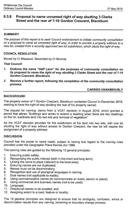
Appendix
A – extract of Ordinary Council Minutes 27 May 2019
Appendix
A – extract of Ordinary Council Minutes 27 May 2019
Site Map of
Unnamed Right of Way (highlighted red)
Abutting 3 Clarke
Street and the rear of 7-19 Gordon Crescent, Blackburn
_____________________________________________________________________
_____________________________________________________________________
Ordinary Council Minutes 16
September 2019
9.3.3 Delegated
Decisions July 2019
SUMMARY
The following activity was undertaken by officers under
delegated authority during July 2019.
|
DELEGATION
|
FUNCTION
|
Number for July 2018
|
Number for July 2019
|
|
Planning and Environment Act
1987
|
Delegated Decisions
|
144
|
114
|
|
Strategic Planning Decisions
|
Nil
|
Nil
|
|
Telecommunications Act 1997
|
|
Nil
|
Nil
|
|
Subdivision Act 1988
|
|
21
|
29
|
|
Gaming Control Act 1991
|
|
Nil
|
Nil
|
|
Building Act 1993
|
Dispensations & Applications to
Building Control Commission
|
73
|
57
|
|
Liquor Control Reform Act 1998
|
Objections and Prosecutions
|
1
|
1
|
|
Food Act 1984
|
Food Act Orders
|
4
|
2
|
|
Public Health & Wellbeing
Act 2008
|
Improvement /
Prohibition Notices
|
6
|
2
|
|
Local Government Act 1989
|
Temporary Rd. Closures
|
5
|
1
|
|
Other Delegations
|
CEO Signed Contracts between $150,000 - $750,000
|
1
|
5
|
|
Property Sales and Leases
|
11
|
13
|
|
Documents to which Council seal affixed
|
2
|
2
|
|
Vendor Payments
|
1259
|
1423
|
|
Parking Amendments
|
12
|
7
|
|
Parking Infringements written off (not
able to be collected)
|
234
|
336
|
DELEGATED DECISIONS MADE ON PLANNING APPLICATIONS JULY 2019
All decisions are the subject of conditions which July
in some circumstances alter the use of development approved, or specific
grounds of refusal is an application is not supported.
|
Appl No
|
Date
|
Decision
|
Street
Address
|
Ward
|
Proposed Use or Development
|
Application
Type
|
|
WH/2019/362
|
18-07-19
|
Application Lapsed
|
730 Canterbury Road
Surrey Hills Vic 3127
|
Riversdale
|
Buildings and works for the construction
of a new fence including associated buildings and works within 4 metres of
protected SLO9 trees
|
VicSmart - General Application
|
|
WH/2019/462
|
15-07-19
|
Application Lapsed
|
3 Boongarry Avenue
Blackburn Vic 3130
|
Central
|
Installation of a pool and pool fence
|
VicSmart - General Application
|
|
WH/2019/491
|
23-07-19
|
Application Lapsed
|
24 Bishop Street
Box Hill Vic 3128
|
Elgar
|
2 lot subdivision
|
Subdivision
|
|
WH/2019/87
|
29-07-19
|
Application Lapsed
|
2 Mount Pleasant Road Nunawading Vic 3131
|
Springfield
|
Construction of five (5) dwellings
comprising four (4) three storey dwellings and one (1) double storey dwelling
and associated tree removal.
|
Multiple Dwellings
|
|
Appl No
|
Date
|
Decision
|
Street
Address
|
Ward
|
Proposed Use or Development
|
Application
Type
|
|
WH/2012/146/H
|
10-07-19
|
Delegate Approval - S72 Amendment
|
105/712 Station Street Box Hill Vic 3128
|
Elgar
|
Section 72 Amendment to "Development
of a nine (9) storey building plus basement car park, use for office,
licensed food and drink premises (café), shop (Beauty Salon), and
convenience shop, access to a Road Zone Category 1, reduction in the parking
requirements of Clause 52.06 and waiver of loading bay requirements at Clause
52.07" to allow for use of land for the purpose of an office in lieu of
convenience store
|
Permit Amendment
|
|
WH/2014/567/B
|
09-07-19
|
Delegate Approval - S72 Amendment
|
88 Dorking Road Box Hill North Vic 3129
|
Elgar
|
Buildings and works within 4m of a
protected tree in SLO9
|
Permit Amendment
|
|
WH/2014/695/A
|
24-07-19
|
Delegate Approval - S72 Amendment
|
4 Alice Street
Burwood East Vic 3151
|
Morack
|
Construction of eight (8) double storey
dwellings and works within 4 metres of a protected tree
|
Permit Amendment
|
|
Appl No
|
Date
|
Decision
|
Street
Address
|
Ward
|
Proposed Use or Development
|
Application
Type
|
|
WH/2015/1070/A
|
12-07-19
|
Delegate Approval - S72 Amendment
|
151 Highbury Road
Burwood Vic 3125
|
Riversdale
|
Construction of two double storey
dwellings and the alteration of access to a road in a Road Zone, Category 1
|
Permit Amendment
|
|
WH/2015/25/B
|
23-07-19
|
Delegate Approval - S72 Amendment
|
22-24 Blackburn Road
Blackburn Vic 3130
|
Central
|
Construction of a multi storey building
for retail and residential uses, reduction in car parking, waiver of loading
facilities, and alteration of access to a road in a Road Zone, Category 1
|
Multiple Dwellings
|
|
WH/2015/715/F
|
15-07-19
|
Delegate Approval - S72 Amendment
|
12-14 Nelson Road Box Hill Vic 3128
|
Elgar
|
Amendment to the plans for internal alterations
(consolidation of units) and addition of a south-facing window at level 6 of
the approved building.
|
Permit Amendment
|
|
WH/2015/732/B
|
10-07-19
|
Delegate Approval - S72 Amendment
|
7 Inverness Avenue
Burwood Vic 3125
|
Riversdale
|
Construction of four double storey
dwellings
|
Permit Amendment
|
|
WH/2016/1084/A
|
10-07-19
|
Delegate Approval - S72 Amendment
|
116 Mahoneys Road
Forest Hill Vic 3131
|
Central
|
Three new double storey dwellings
|
Permit Amendment
|
|
Appl No
|
Date
|
Decision
|
Street
Address
|
Ward
|
Proposed Use or Development
|
Application
Type
|
|
WH/2016/1143/A
|
10-07-19
|
Delegate Approval - S72 Amendment
|
78 Middleborough Road
Burwood East Vic 3151
|
Riversdale
|
Development of two (six storey) apartment
buildings and associated reduction of car parking requirements and alteration
of access to a road in a Road Zone Category 1
|
Permit Amendment
|
|
WH/2016/1173/A
|
01-07-19
|
Delegate Approval - S72 Amendment
|
78 Middleborough Road
Burwood East Vic 3151
|
Riversdale
|
Development of a (six storey) apartment
building and alteration of access to a road in a Road Zone Category 1
|
Permit Amendment
|
|
WH/2016/456/F
|
03-07-19
|
Delegate Approval - S72 Amendment
|
31-39 Norcal Road
Nunawading Vic 3131
|
Springfield
|
Buildings and works for a warehouse
development, use of the land for a food and drink premises and offices,
internally illuminated signage, reduction in the standard car parking
requirement and native vegetation removal
|
Permit Amendment
|
|
Appl No
|
Date
|
Decision
|
Street
Address
|
Ward
|
Proposed Use or Development
|
Application
Type
|
|
WH/2016/456/G
|
03-07-19
|
Delegate Approval - S72 Amendment
|
31-37 Norcal Road
Nunawading Vic 3131
|
Springfield
|
Buildings and works for a warehouse
development, use of the land for a food and drink premises and offices,
internally illuminated signage, reduction in the standard car parking
requirement and native vegetation removal
|
Permit Amendment
|
|
WH/2016/456/H
|
03-07-19
|
Delegate Approval - S72 Amendment
|
44/31-37 Norcal Road Nunawading Vic 3131
|
Springfield
|
Buildings and works for a warehouse
development, use of the land for a food and drink premises and offices,
internally illuminated signage, reduction in the standard car parking
requirement and native vegetation removal
|
Permit Amendment
|
|
WH/2016/793/A
|
16-07-19
|
Delegate Approval - S72 Amendment
|
11 Bronte Avenue Burwood Vic 3125
|
Riversdale
|
Construction of three double storey
dwellings
|
Permit Amendment
|
|
WH/2017/117/A
|
10-07-19
|
Delegate Approval - S72 Amendment
|
78 Middleborough Road Burwood East Vic
3151
|
Riversdale
|
Development of a six (6) storey apartment
building comprising 70 dwellings and ground floor food and drink premises
|
Permit Amendment
|
|
Appl No
|
Date
|
Decision
|
Street
Address
|
Ward
|
Proposed Use or Development
|
Application
Type
|
|
WH/2018/100/A
|
30-07-19
|
Delegate Approval - S72 Amendment
|
274-278 Whitehorse Road
Nunawading Vic 3131
|
Springfield
|
Buildings and works associated with
additions to the redevelopment of the existing restricted retail premises,
use of the land as a food and drink premises, a reduction in carparking
requirements, alterations to access to a road zone Category 1 and display of
business identification signage
|
Permit Amendment
|
|
WH/2018/23/A
|
15-07-19
|
Delegate Approval - S72 Amendment
|
2A Laughlin Avenue
Nunawading Vic 3131
|
Springfield
|
Use and development of two additional
independent living units as part of the existing retirement village including
associated buildings and works within 4 metres of protected SLO9 trees and
SLO9 tree removal
|
Permit Amendment
|
|
Appl No
|
Date
|
Decision
|
Street
Address
|
Ward
|
Proposed Use or Development
|
Application
Type
|
|
WH/2018/652/A
|
26-07-19
|
Delegate Approval - S72 Amendment
|
63 Katrina Street Blackburn North Vic
3130
|
Central
|
Amendment to plans for planning permit
WH/2018/652 ( issued for the Construction of a three storey mixed-use
building comprising one shop and one dwelling) to include alterations to
northern second floor balcony.
|
Permit Amendment
|
|
WH/2019/1/A
|
15-07-19
|
Delegate Approval - S72 Amendment
|
6/23A Cook Road Mitcham Vic 3132
|
Springfield
|
Buildings and works for the construction
of a first-floor mezzanine and storage area and use of the land for car sales
|
Permit Amendment
|
|
WH/2019/267/A
|
15-07-19
|
Delegate Approval - S72 Amendment
|
Shop 68/1 Main Street
Box Hill Vic 3128
|
Elgar
|
new shop frontage and display of
illuminated business identification signage
|
Permit Amendment
|
|
WH/2017/814/A
|
22-07-19
|
Delegate NOD - S72 Amendment
|
46 Victoria Crescent
Mont Albert Vic 3127
|
Elgar
|
The construction of two new dwellings
|
Permit Amendment
|
|
Appl No
|
Date
|
Decision
|
Street
Address
|
Ward
|
Proposed Use or Development
|
Application
Type
|
|
WH/2018/1290
|
03-07-19
|
Delegate NOD Issued
|
339-347 Warrigal Road Burwood Vic 3125
|
Riversdale
|
To construct a building or carry out
works, extend an existing Funeral Parlour. Buildings and works within 4
metres of vegetation. Display one internally illuminated business
identification pylon sign, display one direction sign, Display two
above-verandah signs, one above verandah business identification sign and one
business identification sign.
|
Residential (Other)
|
|
WH/2018/629
|
11-07-19
|
Delegate NOD Issued
|
22 Simmons Street Box Hill North Vic 3129
|
Elgar
|
Development of the land for the
construction of two (2) double storey dwellings, including associated
buildings and works within 4 metres of protected SLO9 trees
|
Multiple Dwellings
|
|
WH/2018/789
|
11-07-19
|
Delegate NOD Issued
|
10 Fairlane Court
Blackburn North Vic 3130
|
Central
|
Construction of Two (2) Double Storey
Dwellings on a Lot & Removal of Vegetation
|
Multiple Dwellings
|
|
Appl No
|
Date
|
Decision
|
Street
Address
|
Ward
|
Proposed Use or Development
|
Application
Type
|
|
WH/2019/103
|
25-07-19
|
Delegate NOD Issued
|
10 Longstaff Court Vermont Vic 3133
|
Morack
|
Buildings and works within 4 metres of
protected SLO8 tree and lopping of SLO8 tree located within 28 the Mews,
Vermont
|
Special Landscape Area
|
|
WH/2019/233
|
24-07-19
|
Delegate NOD Issued
|
256 Morack Road Vermont South VIC 3133
|
Morack
|
Construction of two (2) double storey
dwellings with associated tree removal and buildings and works within 4
metres of protected trees
|
Multiple Dwellings
|
|
WH/2019/401
|
10-07-19
|
Delegate NOD Issued
|
12-14 Nelson Road Box Hill Vic 3128
|
Elgar
|
Selling and consumption of liquor
(Restaurant and cafe licence - Tenancy 1)
|
Liquor Licence
|
|
WH/2018/1045
|
23-07-19
|
Delegate Permit Issued
|
25 Byron Street Box Hill South Vic 3128
|
Riversdale
|
Development of the land for two (2)
double storey dwellings, including associated buildings and works within 4
metres of protected SLO9 trees and SLO9 tree removal
|
Multiple Dwellings
|
|
WH/2018/1245
|
08-07-19
|
Delegate Permit Issued
|
45 Shannon Street Box Hill North Vic 3129
|
Elgar
|
Construction of three double storey
dwellings and removal of vegetation
|
Multiple Dwellings
|
|
Appl No
|
Date
|
Decision
|
Street
Address
|
Ward
|
Proposed Use or Development
|
Application
Type
|
|
WH/2018/1271
|
04-07-19
|
Delegate Permit Issued
|
8 Victoria Crescent
Mont Albert Vic 3127
|
Elgar
|
Works in a Heritage Overlay Area,
comprising the construction of a double storey dwelling at the rear of the
existing dwelling, extension of the existing dwelling, buildings and works
within 4 metres of vegetation, vegetation removal.
|
Multi Dwelling and Use
|
|
WH/2018/1317
|
08-07-19
|
Delegate Permit Issued
|
46 Betula Avenue
Vermont Vic 3133
|
Springfield
|
Construction of Two (2) Double Storey
Dwellings and Vegetation Removal
|
Multiple Dwellings
|
|
WH/2018/1332
|
27-07-19
|
Delegate Permit Issued
|
11 Francesca Street
Mont Albert North Vic 3129
|
Elgar
|
Buildings and works for the construction
of four double storey dwellings, associated tree removal, buildings and works
within 4 metres of protected trees (SLO9)
|
Multiple Dwellings
|
|
WH/2018/1345
|
11-07-19
|
Delegate Permit Issued
|
15 William Street
Box Hill Vic 3128
|
Elgar
|
Development of the land for two (2)
double storey dwellings including associated buildings and works within 4
metres of protected trees and SLO9 tree removal
|
Multiple Dwellings
|
|
Appl No
|
Date
|
Decision
|
Street
Address
|
Ward
|
Proposed Use or Development
|
Application
Type
|
|
WH/2018/662
|
16-07-19
|
Delegate Permit Issued
|
69 Blackburn Road
Blackburn Vic 3130
|
Central
|
Construction of two new double storey
dwellings and associated tree removal and alteration of access to a road in a
Road Zone Category 1
|
Multiple Dwellings
|
|
WH/2018/705
|
09-07-19
|
Delegate Permit Issued
|
24 Betula Avenue
Nunawading Vic 3131
|
Springfield
|
Development of the land for the
construction of four double storey dwellings, with associated tree removal
and buildings and works within 4 metres of protected trees
|
Multiple Dwellings
|
|
WH/2019/106
|
15-07-19
|
Delegate Permit Issued
|
23 Florence Road
Surrey Hills Vic 3127
|
Riversdale
|
Buildings and works within 4m of
significant trees
|
Special Landscape Area
|
|
WH/2019/172
|
15-07-19
|
Delegate Permit Issued
|
15 Hawkins Avenue
Mont Albert North Vic 3129
|
Elgar
|
Removal of Trees
|
Special Landscape Area
|
|
WH/2019/174
|
25-07-19
|
Delegate Permit Issued
|
16 Grace Street
Mont Albert Vic 3127
|
Elgar
|
Tree removal (5 trees)
|
Special Landscape Area
|
|
WH/2019/184
|
24-07-19
|
Delegate Permit Issued
|
1/17 Walker Avenue
Mitcham Vic 3132
|
Springfield
|
Extension to an existing dwelling on a
lot less than 500 square meters and within 4 metres of protected vegetation.
|
Single Dwelling < 300m2
|
|
WH/2019/20
|
17-07-19
|
Delegate Permit Issued
|
8 Alfred Street
Blackburn Vic 3130
|
Central
|
Use and development of a warehouse with
ancillary office space
|
Industrial
|
|
Appl No
|
Date
|
Decision
|
Street
Address
|
Ward
|
Proposed Use or Development
|
Application
Type
|
|
WH/2019/220
|
22-07-19
|
Delegate Permit Issued
|
75 Laburnum Street
Blackburn VIC 3130
|
Central
|
To subdivide the title to create five
lots and common property
|
Subdivision
|
|
WH/2019/255
|
04-07-19
|
Delegate Permit Issued
|
1/17 Burnt Street
Nunawading Vic 3131
|
Springfield
|
Removal of Trees
|
Special Landscape Area
|
|
WH/2019/289
|
29-07-19
|
Delegate Permit Issued
|
35 Twyford Street
Box Hill North Vic 3129
|
Elgar
|
2 lot subdivision
|
VicSmart - Subdivision
|
|
WH/2019/320
|
01-07-19
|
Delegate Permit Issued
|
13 Elder Street
Blackburn Vic 3130
|
Central
|
Buildings and works within 4 metres of a
protected SLO9 tree
|
VicSmart - General Application
|
|
WH/2019/327
|
04-07-19
|
Delegate Permit Issued
|
25 Thomas Street
Mitcham Vic 3132
|
Springfield
|
Buildings and works within 4m of
vegetation & alteration to an existing dwelling (construction a veranda)
in a heritage overlay
|
Heritage
|
|
WH/2019/331
|
08-07-19
|
Delegate Permit Issued
|
28 Elder Street
Blackburn VIC 3130
|
Central
|
Buildings and works within 4 metres of
SLO9 protected trees
|
Special Landscape Area
|
|
WH/2019/353
|
10-07-19
|
Delegate Permit Issued
|
1075 Whitehorse Road
Box Hill Vic 3128
|
Elgar
|
Buildings and works to provide two (2)
shipping containers, deck and canopy roof
|
Education
|
|
WH/2019/373
|
18-07-19
|
Delegate Permit Issued
|
49 Betula Avenue
Vermont VIC 3133
|
Springfield
|
Use of land for motor repairs, car sales
and sales of automotive parts.
|
Change of Use
|
|
WH/2019/409
|
12-07-19
|
Delegate Permit Issued
|
14 Haydn Street
Blackburn Vic 3130
|
Central
|
Removal of two protected trees in the
Significant Landscape Overlay Schedule 2
|
Special Landscape Area
|
|
Appl No
|
Date
|
Decision
|
Street
Address
|
Ward
|
Proposed Use or Development
|
Application
Type
|
|
WH/2019/420
|
18-07-19
|
Delegate Permit Issued
|
18 Lawford Street
Box Hill North Vic 3129
|
Elgar
|
2 lot subdivision
|
Subdivision
|
|
WH/2019/519
|
08-07-19
|
Delegate Permit Issued
|
30 Cosgrove Street
Vermont Vic 3133
|
Morack
|
Two lot subdivision
|
Subdivision
|
|
WH/2019/533
|
16-07-19
|
Delegate Permit Issued
|
34 Jessie Street
Blackburn North Vic 3130
|
Central
|
Removal of 1 tree (No T7)
|
VicSmart - Tree
|
|
WH/2019/534
|
16-07-19
|
Delegate Permit Issued
|
34 Jessie Street
Blackburn North Vic 3130
|
Central
|
Remove a tree (No T9)
|
VicSmart - Tree
|
|
WH/2019/536
|
16-07-19
|
Delegate Permit Issued
|
34 Jessie Street
Blackburn North Vic 3130
|
Central
|
Removal of a tree (No T2)
|
VicSmart - Tree
|
|
WH/2019/558
|
03-07-19
|
Delegate Permit Issued
|
6 Ian Crescent
Mitcham Vic 3132
|
Springfield
|
Removal of one tree
|
VicSmart - Tree
|
|
WH/2019/564
|
02-07-19
|
Delegate Permit Issued
|
15 Summit Road
Burwood Vic 3125
|
Riversdale
|
3 lot subdivision
|
Subdivision
|
|
WH/2019/565
|
16-07-19
|
Delegate Permit Issued
|
1201-1205 Riversdale Road
Box Hill South VIC 3128
|
Riversdale
|
Buildings and works to alter timber
sills, replace existing windows and doors and install condenser unit
|
Heritage
|
|
WH/2019/567
|
01-07-19
|
Delegate Permit Issued
|
9 Elonara Road
Vermont South VIC 3133
|
Morack
|
Removal of one tree
|
VicSmart - Tree
|
|
WH/2019/574
|
02-07-19
|
Delegate Permit Issued
|
11 Johnston Street
Burwood Vic 3125
|
Riversdale
|
Three lot subdivision
|
Subdivision
|
|
WH/2019/584
|
01-07-19
|
Delegate Permit Issued
|
5 Cairo Road
Mont Albert North Vic 3129
|
Elgar
|
Removal of one (1) tree
|
VicSmart - Tree
|
|
WH/2019/599
|
19-07-19
|
Delegate Permit Issued
|
62 Relowe Crescent
Mont Albert North Vic 3129
|
Elgar
|
Three lot subdivision
|
Subdivision
|
|
WH/2019/60
|
19-07-19
|
Delegate Permit Issued
|
2 Loraine Avenue
Box Hill North Vic 3129
|
Elgar
|
Removal of three (3) protected trees,
together with buildings and works within 4 metres of protected trees (SLO9).
|
Special Landscape Area
|
|
Appl No
|
Date
|
Decision
|
Street
Address
|
Ward
|
Proposed Use or Development
|
Application
Type
|
|
WH/2019/600
|
11-07-19
|
Delegate Permit Issued
|
6 Alwyn Court
Mitcham Vic 3132
|
Springfield
|
Removal of one (1) Melaleuca
styphelioides (Prickly Paperbark) tree.
|
VicSmart - Tree
|
|
WH/2019/608
|
01-07-19
|
Delegate Permit Issued
|
24 Dalmor Avenue Mitcham Vic 3132
|
Springfield
|
Removal of one (1) tree
|
VicSmart - Tree
|
|
WH/2019/609
|
01-07-19
|
Delegate Permit Issued
|
24 Dalmor Avenue Mitcham Vic 3132
|
Springfield
|
Removal of one (1) tree
|
VicSmart - Tree
|
|
WH/2019/611
|
01-07-19
|
Delegate Permit Issued
|
24 Dalmor Avenue Mitcham Vic 3132
|
Springfield
|
Removal of one (1) tree
|
VicSmart - Tree
|
|
WH/2019/615
|
22-07-19
|
Delegate Permit Issued
|
33 Landale Street Box Hill Vic 3128
|
Elgar
|
Buildings and works to construct a front
gate
|
VicSmart - General Application
|
|
WH/2019/617
|
02-07-19
|
Delegate Permit Issued
|
2 Grigg Avenue
Vermont Vic 3133
|
Springfield
|
Two lot subdivision
|
VicSmart - Subdivision
|
|
WH/2019/624
|
22-07-19
|
Delegate Permit Issued
|
20 Orchard Grove Blackburn South Vic 3130
|
Central
|
Removal of one tree
|
VicSmart - Tree
|
|
WH/2019/626
|
10-07-19
|
Delegate Permit Issued
|
16 Rishon Avenue
Blackburn South Vic 3130
|
Riversdale
|
Removal of one (1) SLO9 tree
|
VicSmart - Tree
|
|
WH/2019/628
|
29-07-19
|
Delegate Permit Issued
|
221 Highbury Road Burwood Vic 3125
|
Riversdale
|
Six lot subdivision
|
Subdivision
|
|
WH/2019/634
|
02-07-19
|
Delegate Permit Issued
|
45 Great Western Drive
Vermont South Vic 3133
|
Morack
|
Two lot subdivision
|
Subdivision
|
|
WH/2019/636
|
04-07-19
|
Delegate Permit Issued
|
17 Lynette Street
Nunawading Vic 3131
|
Springfield
|
Buildings and works and within 4 metres
of protected vegetation
|
VicSmart - General Application
|
|
WH/2019/640
|
22-07-19
|
Delegate Permit Issued
|
92B Railway Road
Blackburn Vic 3130
|
Central
|
Construct and Carry Out Works (DDO8)
|
VicSmart - General Application
|
|
WH/2019/645
|
17-07-19
|
Delegate Permit Issued
|
4 Selwyn Street
Blackburn Vic 3130
|
Central
|
Removal of one (1) Eucalyptus mannifera
– Red Spotted Gum tree.
|
VicSmart - Tree
|
|
Appl No
|
Date
|
Decision
|
Street
Address
|
Ward
|
Proposed Use or Development
|
Application
Type
|
|
WH/2019/646
|
18-07-19
|
Delegate Permit Issued
|
31 Denis Street
Mitcham Vic 3132
|
Springfield
|
Two lot subdivision
|
VicSmart - Subdivision
|
|
WH/2019/648
|
11-07-19
|
Delegate Permit Issued
|
5 Eugenia Street
Nunawading Vic 3131
|
Springfield
|
Removal of one (1) SLO9 tree
|
VicSmart - Tree
|
|
WH/2019/653
|
09-07-19
|
Delegate Permit Issued
|
68 Vanbrook Street Forest Hill Vic 3131
|
Morack
|
Two lot subdivision
|
Subdivision
|
|
WH/2019/656
|
09-07-19
|
Delegate Permit Issued
|
710A Whitehorse Road Mitcham Vic 3132
|
Springfield
|
Two lot subdivision
|
VicSmart - Subdivision
|
|
WH/2019/657
|
18-07-19
|
Delegate Permit Issued
|
385 Springfield Road
Nunawading Vic 3131
|
Springfield
|
Two lot subdivision
|
Subdivision
|
|
WH/2019/659
|
24-07-19
|
Delegate Permit Issued
|
16 Joyce Street
Nunawading Vic 3131
|
Springfield
|
Removal of one (1) Cupressus sempervirens
– Italian Cypress tree.
|
VicSmart - Tree
|
|
WH/2019/661
|
22-07-19
|
Delegate Permit Issued
|
25 Sherwood Rise Vermont South Vic 3133
|
Morack
|
Construction of front fence in an overlay
|
VicSmart - General Application
|
|
WH/2019/667
|
24-07-19
|
Delegate Permit Issued
|
4 Kerrimuir Street Box Hill North Vic
3129
|
Elgar
|
Construction of new front fence within 4
metres of a protected tree
|
VicSmart - General Application
|
|
WH/2019/678
|
18-07-19
|
Delegate Permit Issued
|
8 Karen Street
Box Hill North VIC 3129
|
Elgar
|
Two lot subdivision
|
VicSmart - Subdivision
|
|
WH/2019/684
|
24-07-19
|
Delegate Permit Issued
|
25 Hibiscus Road Blackburn North Vic 3130
|
Central
|
Removal of one tree (tree 1)
|
VicSmart - Tree
|
|
WH/2019/691
|
29-07-19
|
Delegate Permit Issued
|
87 Benwerrin Drive Burwood East Vic 3151
|
Riversdale
|
Two lot subdivision
|
Subdivision
|
|
WH/2019/696
|
30-07-19
|
Delegate Permit Issued
|
170 Station Street Box Hill South Vic
3128
|
Riversdale
|
Removal of one protected tree in the
Significant Landscape Overlay Schedule 9
|
VicSmart - Tree
|
|
Appl No
|
Date
|
Decision
|
Street
Address
|
Ward
|
Proposed Use or Development
|
Application
Type
|
|
WH/2019/655
|
11-07-19
|
Delegate Permit Issued
|
3 Barbara Street Mont Albert North Vic
3129
|
Elgar
|
Tree removal
|
VicSmart - Tree
|
|
WH/2019/700
|
24-07-19
|
Delegate Permit Issued
|
6 Murra Street Burwood VIC 3125
|
Riversdale
|
Removal of Vegetation within Significant
Landscape Overlay - Schedule 9
|
VicSmart - Tree
|
|
WH/2019/95
|
10-07-19
|
Delegate Permit Issued
|
29 McCubbin Street Burwood VIC 3125
|
Riversdale
|
Construction of 3 dwellings and buildings
and works within 4m of vegetation
|
Multiple Dwellings
|
|
WH/2014/402/C
|
10-07-19
|
Delegate Refusal - S72 Amend-ment
|
2/481 Middleborough Road Box Hill North
Vic 3129
|
Elgar
|
Construction three double storey
dwellings
|
Permit Amendment
|
|
WH/2017/1053
|
04-07-19
|
Delegate Refusal Issued
|
10 Short Street
Vermont Vic 3133
|
Springfield
|
Development of the land for four double
storey dwellings, including associated buildings and works and tree removal.
|
Multiple Dwellings
|
|
WH/2018/1142
|
17-07-19
|
Delegate Refusal Issued
|
9 Devon Drive
Blackburn North VIC 3130
|
Central
|
Development of the land for two (2)
double storey dwellings, including associated buildings and works within 4
metres of protected trees and SLO9 tree removal.
|
Multiple Dwellings
|
|
WH/2018/1199
|
01-07-19
|
Delegate Refusal Issued
|
108 Brunswick Road Mitcham Vic 3132
|
Springfield
|
Construction of 3 double storey dwellings
and tree removal
|
Multiple Dwellings
|
|
WH/2018/1416
|
19-07-19
|
Delegate Refusal Issued
|
24 Bishop Street Box Hill Vic 3128
|
Elgar
|
Buildings and works within 4 metres of
protected SLO9 trees and SLO9 tree removal
|
Special Landscape Area
|
|
Appl No
|
Date
|
Decision
|
Street
Address
|
Ward
|
Proposed Use or Development
|
Application
Type
|
|
WH/2018/837
|
01-07-19
|
Delegate Refusal Issued
|
35 Hay Street
Box Hill South Vic 3128
|
Riversdale
|
Construction of 9 double storey and
triple storey town houses
|
Multiple Dwellings
|
|
WH/2019/572
|
04-07-19
|
Delegate Refusal Issued
|
1/65 Orchard Crescent
Mont Albert North Vic 3129
|
Elgar
|
removal of tree
|
VicSmart - Tree
|
|
WH/2019/573
|
04-07-19
|
Delegate Refusal Issued
|
1/65 Orchard Crescent
Mont Albert North Vic 3129
|
Elgar
|
Removal of one (1) Eucalyptus
camaldul-ensis River Red Gum tree.
|
VicSmart - Tree
|
|
WH/2019/579
|
08-07-19
|
Delegate Refusal Issued
|
33 Morloc Street Forest Hill Vic 3131
|
Springfield
|
Removal of one protected tree in the SLO9
|
VicSmart - Tree
|
|
WH/2019/587
|
04-07-19
|
Delegate Refusal Issued
|
1/40 Hamilton Street Mont Albert Vic 3127
|
Elgar
|
Buildings and works to externally paint
an existing building and business identification signage
|
VicSmart - General Application
|
|
WH/2019/594
|
18-07-19
|
Delegate Refusal Issued
|
6 Nelson Road
Box Hill Vic 3128
|
Elgar
|
removal of easement
|
Subdivision
|
|
WH/2019/598
|
10-07-19
|
Delegate Refusal Issued
|
7 Tiller Street
Burwood East Vic 3151
|
Riversdale
|
Removal of one tree
|
VicSmart - Tree
|
|
WH/2019/614
|
17-07-19
|
Delegate Refusal Issued
|
23 Ireland Street Burwood Vic 3125
|
Riversdale
|
Removal of a tree
|
VicSmart - Tree
|
|
WH/2019/622
|
15-07-19
|
Delegate Refusal Issued
|
4 Gidgee Court Forest Hill Vic 3131
|
Morack
|
Removal of one (1) Eucalyptus
camaldul-ensis River Red Gumtree.
|
VicSmart - Tree
|
|
WH/2019/672
|
31-07-19
|
Delegate Refusal Issued
|
5 Haslemere Road Mitcham Vic 3132
|
Springfield
|
Removal of one protected tree
|
VicSmart - Tree
|
|
WH/2019/619
|
04-07-19
|
Withdrawn
|
1/65 Orchard Crescent
Mont Albert North Vic 3129
|
Elgar
|
Removal of tree
|
VicSmart - Tree
|
|
Appl No
|
Date
|
Decision
|
Street
Address
|
Ward
|
Proposed Use or Development
|
Application
Type
|
|
WH/2019/638
|
11-07-19
|
Withdrawn
|
33 Landale Street Box Hill Vic 3128
|
Elgar
|
Buildings and works to construct a front
gate
|
VicSmart - General Application
|
WH/2019/698
|
18-07-19
|
Withdrawn
|
11 Lexton Road Box Hill North Vic 3129
|
Elgar
|
Five lot subdivision
|
Subdivision
|
|
WH/2019/97
|
18-07-19
|
Withdrawn
|
658 Canterbury Road Vermont Vic 3133
|
Morack
|
Construction of Four Double Storey
Dwellings
|
Multiple Dwellings
|
|
WH/9999/39/A
|
08-07-19
|
Withdrawn
|
14 Banksia Street Burwood Vic 3125
|
Riversdale
|
Use of land for a Dance Studio (Indoor
Recreation Facility) including an ancillary Cafe, and buildings and works for
alterations and additions to the existing shops
|
Permit Amendment
|
BUILDING
DISPENSATIONS/APPLICATIONS JULY 2019
|
Address
|
Date
|
Ward
|
Result
|
|
100 Orchard Grove, Blackburn South
|
11-07-19
|
Central
|
Consent Granted 76
|
|
13 Bridgeford Avenue, Blackburn North
|
02-07-19
|
Central
|
Consent Granted 79
|
|
19 Shafer Road, Blackburn North
|
17-07-19
|
Central
|
Consent Granted 76
|
|
26 Kevin Avenue, Blackburn
|
15-07-19
|
Central
|
Consent Granted 74
|
|
26 Patricia Road, Blackburn
|
11-07-19
|
Central
|
Consent Granted 89
|
|
32-34 Main Street, Blackburn
|
12-07-19
|
Central
|
Consent Granted 90
|
|
5 Lilac Court, Blackburn North
|
23-07-19
|
Central
|
Consent Granted 74, 85
|
|
1 Orana Street, Blackburn
|
02-07-19
|
Central
|
Consent Refused 80
|
|
100 Orchard Grove, Blackburn South
|
11-07-19
|
Central
|
Consent Refused 79, 74
|
|
14 Heath Street, Blackburn
|
19-07-19
|
Central
|
Consent Refused 89
|
|
19 Dixon Grove, Blackburn
|
22-07-19
|
Central
|
Consent Refused 74
|
|
24 Gunyah Road, Blackburn North
|
05-07-19
|
Central
|
Consent Refused 83, 74
|
|
33 Aldinga Street, Blackburn South
|
25-07-19
|
Central
|
Consent Refused 89
|
|
44 Faulkner Street, Forest Hill
|
03-07-19
|
Central
|
Consent Refused 79
|
|
18 Primula Street, Blackburn North
|
25-07-19
|
Central
|
Withdrawn 73
|
|
1 Gracefield Drive, Box Hill North
|
11-07-19
|
Elgar
|
Consent Granted 79, 80
|
|
12 Chessell Street, Mont Albert North
|
29-07-19
|
Elgar
|
Consent Granted 80
|
|
26 Tower Street, Surrey Hills
|
19-07-19
|
Elgar
|
Consent Granted 74
|
|
440 Belmore Road, Mont Albert North
|
12-07-19
|
Elgar
|
Consent Granted 74, 79
|
|
545-563 Station Street, Box Hill
|
12-07-19
|
Elgar
|
Consent Granted 116
|
|
Address
|
Date
|
Ward
|
Result
|
|
14 Aspinall Road, Box Hill North
|
03-07-19
|
Elgar
|
Consent Refused 74
|
14 Wingrove Street, Forest Hill
|
01-07-19
|
Morack
|
Consent Granted 80
|
|
7 Cedar Court, Forest Hill
|
26-07-19
|
Morack
|
Consent Granted 74, 75, 79
|
|
16 Glenice Avenue, Blackburn South
|
03-07-19
|
Riversdale
|
Consent Granted 74
|
|
2 Gareth Drive, Burwood East
|
15-07-19
|
Riversdale
|
Consent Granted 74
|
|
24 Grange Road, Blackburn South
|
18-07-19
|
Riversdale
|
Consent Granted 76, 79
|
|
33 Davis Street, Burwood East
|
03-07-19
|
Riversdale
|
Consent Granted 79
|
|
98 Roslyn Street, Burwood
|
03-07-19
|
Riversdale
|
Consent Granted 74
|
|
21 Faelen Street, Burwood
|
12-07-19
|
Riversdale
|
Consent Refused 80, 79, 75
|
|
24 Grange Road, Blackburn South
|
18-07-19
|
Riversdale
|
Consent Refused 74
|
|
6 Medhurst Street, Burwood East
|
12-07-19
|
Riversdale
|
Consent Refused 81
|
|
98 Roslyn Street, Burwood
|
05-07-19
|
Riversdale
|
Consent Refused 81, 82
|
|
10 Rosstrevor Crescent, Mitcham
|
03-07-19
|
Springfield
|
Consent Granted 89
|
|
14 Shrewsbury Road, Nunawading
|
15-07-19
|
Springfield
|
Consent Granted 79
|
|
15 Winifred Street, Nunawading
|
01-07-19
|
Springfield
|
Consent Granted 79
|
|
16 Joyce Street, Nunawading
|
02-07-19
|
Springfield
|
Consent Granted 79
|
|
17 Lynette Street, Nunawading
|
11-07-19
|
Springfield
|
Consent Granted 89
|
|
38 Deakin Street, Mitcham
|
11-07-19
|
Springfield
|
Consent Granted 79, 76
|
|
4 Davison Street, Mitcham
|
18-07-19
|
Springfield
|
Consent Granted 79
|
|
426 Springfield Road, Mitcham
|
15-07-19
|
Springfield
|
Consent Granted 74
|
|
46 Lucknow Street, Mitcham
|
12-07-19
|
Springfield
|
Consent Granted 89, 92
|
|
64 Luckie Street, Nunawading
|
12-07-19
|
Springfield
|
Consent Granted 74
|
|
6A Dawe Road, Mitcham
|
23-07-19
|
Springfield
|
Consent Granted 79
|
|
28 Morden Court, Nunawading
|
11-07-19
|
Springfield
|
Consent Refused 79
|
|
426 Springfield Road, Mitcham
|
15-07-19
|
Springfield
|
Consent Refused 86
|
DELEGATED DECISIONS
MADE ON STRATEGIC PLANNING MATTERS JULY 2019
Under the Planning and Environment Act 1987: Nil
REGISTER OF CONTRACTS
SIGNED BY CEO DELEGATION JULY 2019
|
Contract
Number
|
Service
|
|
30089
|
Specialist
Statutory and Strategic Planning Advisory & Associated Services Panel
|
|
30174
|
Provision
of Workers Compensation
|
|
30172
|
Property
Valuation Services
|
|
30074
|
Cleaning
Services for Various Facilities
|
|
30158
|
Specialised
Training and Professional Development Consultant
|
REGISTER OF PROPERTY
DOCUMENTS EXECUTED JULY 2019
|
Property Address
|
Document Type
|
Document Detail
|
|
Leases
|
|
|
|
64 Jolimont Road, Forest Hill
|
Lease
|
Residential Lease
|
|
Fire Services Property Levy (FSPL)
|
|
|
|
Fire Services Property Levy - Compliance
Certification
|
2019/2020 Annual Return, 2018/2019 Annual
Reconciliation
|
Certification to the State Revenue Office
that Council has complied with the Fire Services Property Levy Act 2012
|
|
Land Transfers
|
|
|
|
Part of discontinued road at rear of 24 Kangerong
Road Box Hill
|
Client Authorisation for Transfer of Land
|
Sale of Discontinued Road
Section 207D Local Government Act 1989
|
|
Part of discontinued road at
rear of 24 Kangerong Road Box Hill
|
Goods Statutory Declaration
|
Duties Act 2000
|
|
Rateability Changes
(Section 154 of the Local Government Act)
|
|
|
|
40
Grandview Road Box Hill South
|
Exempt
|
Unoccupied State Government Owned land
|
|
142-180
Boronia Road Vermont
|
Exempt
|
Unoccupied Crown land (formerly tenanted)
|
|
21
Wattle Valley Road, Mitcham
|
Exempt
|
Unoccupied Council owned site (formerly tenanted)
|
|
2-4 Bruce Street Box Hill
|
Property Now Rateable
|
Former Council owned site sold
|
|
9
Bristow Drive Forest Hill
|
Property Now Rateable
|
Former Ministers residence tenanted
|
|
8
Oxford Street Box Hill
|
Property Now Rateable
|
Former Ministers residence tenanted
|
|
131
Central Road, Nunawading
|
Property Now Rateable
|
Part of former Seventh Day Adventist school site now
under residential redevelopment
|
|
517
Station Street, Box Hill
|
Property Now Rateable
|
Former Council owned site sold and now vacated by
Council
|
|
519-521
Station Street, Box Hill
|
Property Now Rateable
|
Former Council owned site sold and now vacated by
Council
|
REGISTER OF DOCUMENTS AFFIXED
WITH THE COUNCIL SEAL JULY 2019
Development Deed: Related to
Contract of Sale (Volume 1 of 2) between Whitehorse City Council and MAB Bruce
Street Pty Ltd (ACN620633749) for 2A and 2-4 Bruce Street and 7 Elland Avenue
Box Hill (Refer to Item 630)
Instrument of Appointment of
Authorised Officer under the Planning and Environment Act 1987
PARKING
RESTRICTIONS APPROVED BY DELEGATION JULY 2019
Address: Myrtle
Grove, Blackburn: Fuchsia Street to southern end of Myrtle Grove –
both sides
Previously: 20
‘Unrestricted’ parking
spaces
Now: 20
‘3-Hour, 8am to 6pm, Monday to Friday area’ parking spaces
Address: Raleigh
Street, Forest Hill: 1m east of western boundary of 65 Raleigh Street to 9m
west of eastern boundary of 67 Raleigh Street – east side
Previously: 1
‘Unrestricted’ parking space
Now: 1
‘No Stopping’ parking space
Address: Merton
Street, Box Hill: from Maple Street to western boundary of 2 Merton Street
– South side
Previously: 14
‘Unrestricted’ parking
spaces
Now: 14
temporary ‘2-Hour, 8am to 6pm, Monday to Friday’ parking spaces
Address: Merton
Street, Box Hill: from Albion Road to southern boundary of 3 Merton Street
– east side
Previously: 4
‘Unrestricted’ parking
spaces
Now: 4
temporary ‘2-Hour, 8am to 6pm, Monday to Friday’ parking spaces
Address: Roycliff
Court, Box Hill North: from Elgar Road to western boundary of 10 Roycliff
Court– north side
Previously: 10
‘Unrestricted’ parking
spaces
Now: 10
temporary ‘1-Hour, 8am to 6pm, Monday to Friday’ parking spaces
Address: Victory
Street, Mitcham: from 5m south of the northern boundary of 4 Victory Street
to 5m south of the northern boundary of 16 Victory Street – west side
Previously: 10
‘Unrestricted’ parking spaces
Now: 10
‘Permit Zone’ parking spaces
Address: Victory
Street, Mitcham: from Whitehorse Road Service Road to 5m south of the
northern boundary of 4 Victory Street – west side
Previously: 7
‘Unrestricted’ parking spaces
Now: 7
‘2-Hour, 8am-6pm, Monday to Friday’ parking spaces
VENDOR PAYMENT SUMMARY
– SUMS PAID DURING JULY 2019
|
Date
|
Total
Issued
|
Payments
(direct debit, cheques or electronic funds transfer)
|
Transaction Type EFT/CHQ/DD
|
|
04/07/2019
|
23
|
$11,062.81
|
EFC
|
|
04/07/2019
|
265
|
$1,910,284.05
|
EFT
|
|
04/07/2019
|
47
|
$195,933.91
|
CHQ
|
|
09/07/2019
|
1
|
$1,459,561.68
|
EFT
|
|
11/07/2019
|
10
|
$13,463.70
|
EFC
|
|
11/07/2019
|
231
|
$1,488,707.02
|
EFT
|
|
11/07/2019
|
60
|
$71,785.57
|
CHQ
|
|
18/07/2019
|
17
|
$19,378.36
|
EFC
|
|
18/07/2019
|
63
|
$93,555.51
|
CHQ
|
|
18/07/2019
|
237
|
$3,011,837.00
|
EFT
|
|
25/07/2019
|
10
|
$12,220.94
|
EFC
|
|
25/07/2019
|
58
|
$121,334.01
|
CHQ
|
|
25/07/2019
|
427
|
$9,759,520.57
|
EFT
|
|
25/07/2019
|
1
|
$15,028.35
|
EFT
|
|
29/07/2019
|
1
|
$2,756.23
|
EFT
|
|
31/07/2019
|
1
|
$2,695.00
|
EFT
|
|
|
|
|
|
GROSS
|
1452
|
$18,189,124.71
|
|
|
|
|
|
|
Monthly
Lease Payments
|
|
$35,460.29
|
|
|
Direct
Debit Payments
|
|
$160,184.40
|
|
|
CANCELLED
PAYMENTS
|
-29
|
-$31,622.90
|
|
|
NETT
|
1423
|
$18,353,146.50
|
|
Ordinary Council Minutes 16
September 2019
10 Reports
from Delegates, Special Committee Recommendations and Assembly of Councillors
Records
10.1 Reports
by Delegates
(NB: Reports only from Councillors
appointed by Council as delegates to community organisations/committees/groups)
10.1.1 Cr
Carr reported on her attendance at the Audit Advisory Committee on 16 September
2019.
10.1.2 Cr
Ellis reported on her attendance at the Eastern Region Affordable Housing Alliance
on 1 August 2019.
10.1.3 Cr
Barker reported on his attendance at the Box Hill Stakeholder Reference Group
Meeting on 27 August 2019.
10.1.4 Cr
Liu reported on her attendance at the:
· Box Hill Stakeholder Reference
Group Meeting Event on 27 August 2019
· Whitehorse Manningham Regional
Library Corporation Meeting held 28 August 2019; a library event for volunteers
and the launch of the Bert Lewis Room at Box Hill Library.
· Eastern Alliance for Greenhouse
Action on 29 August 2019
· Whitehorse Business Group Board
Meeting on 10 September 2019
10.1.5 Cr
Massoud reported on her attendance at the Audit Advisory Committee on 16
September 2019.
10.1.6 Cr
Munroe reported on his attendance at the Metropolitan Transport Forum on 4
September 2019 at Melbourne Town Hall. Guest speaker Sally Capp, Lord
Mayor City of Melbourne spoke about City of Melbourne Transport Plan, key
points raised are:
·
Provocations
in transport consultation (some of which were not supported by State);
·
Propositions
thought right or worthy of debate;
·
Greatest
congestion on pavements – taking back on-street parking;
·
Every 10% of
pedestrian space adds $2b to economy;
·
Pedestrians
No. 1 – Transport No. 2. Sally has had a change in attitude in
favour of bikes when in London, people are able to commute in work clothes;
·
50km of new
bicycle lanes around the City, more women need to get involved;
·
William and
Exhibition bicycle streets.
These are valuable insights as we
plan for the future of Box Hill.
10.1.7 Cr
Cutts reported on her attendance at the Whitehorse Manningham Regional Library
Corporation Meeting on 28 August 2019 and the Whitehorse Business Group Board
Meeting on 10 September 2019.
10.2 Recommendation
from the Special Committee of Council Meeting of 9 September 2019
|
10.2.1 MAV:
Rescue Our Recycling
Special Committee of Council RECOMMENDATION
Moved by Cr
Liu, Seconded by Cr Munroe
That
Council endorse and actively participates in the Municipal Association of
Victoria’s “Rescue Our Recycling”
Campaign.
Carried Unanimously
Council
Resolution
Moved by Cr Liu, Seconded by Cr Ellis
That the recommendation from
the Special Committee of Council Meeting of 9
September 2019 Item 10.2.1 be received and adopted.
Carried
Unanimously
|
Ordinary Council Minutes 16
September 2019
10.3 Record
of Assembly of Councillors
|
Meeting Date
|
Matter/s
Discussed
|
Councillors
Present
|
Officers Present
|
Disclosures of Conflict of Interest
|
Councillor
/Officer attendance following disclosure
|
|
26.08.19
6:15-7:00pm
|
Councillor Informal Briefing Session
· 2018/19
Annual Financial Statements and Performance Statements
· Proposed
Developments and Other Matters
|
Cr Bennett
(Mayor & Chair)
Cr Barker
Cr Carr
Cr Cutts
Cr Davenport
Cr Liu
Cr Massoud arrived at 6:24pm
Cr Munroe
Cr Stennett
|
ACEO A De Fazio
J Green
N Brown
(AGMHS) T Johnson
P Smith
(AEMG&CS) J Russell
J Thyer
M Hassan
S Cann
H Rowlands
|
Nil
|
Nil
|
|
02.09.19
6:30-9:30pm
|
Strategic Planning Session
· Vicinity
Centres Box Hill Central Master Plan
· Social
Media Policy
· Vision
for Box Hill: Update on Consultation & Porject
· Amendment
C219 Permanent Tree Protection Controls Update on Exhibition
|
Cr Davenportt
(Acting Chair)
Cr Barker
Cr Carr
Cr Cutts
Cr Liu
Cr Massoud
Cr Munroe
Cr Stennett
|
S McMillan
J Green
N Brown
T Wilkinson
P Smith
T De Fazio
K Marriott
J Hansen
A Egan
V McLean
D Shambrook
D Vincent-Smith
M Ackland
R Morrow
|
Nil
|
Nil
|
|
09.09.19
6:30-
|
Councillor Briefing Session
· Special
Committee Agenda 9 September 2019
· Noted
list of Public Speakers
· Other
Business Motion
· Confidential
Other Matter
· Draft
Agenda 16 September 2019
|
Cr Davenport
(Acting Chair)
Cr Barker
Cr Carr
Cr Cutts
Cr Ellis
Cr Liu
Cr Massoud
Cr Munroe
Cr Stennett
|
S McMillan
J Green
N Brown
T Wilkinson
P Smith
T De Fazio
J Russell
K Marriott
J Hansen
A Egan
V McLean
K Sinclair
T Peak
R Anania
J Xu
|
Nil
|
Nil
|
Ordinary Council Minutes 16
September 2019
11 Reports
on Conferences/Seminars Attendance
11.1 Cr
Massoud reported on Managing the Modern Workforce Smart Cities Conference on 11
September 2019.
11.2 Cr
Liu reported on the Melbourne Rail Plan 2020-2050 Council Briefing held on 12
September 2019.
11.3 Cr
Ellis reported on the Ahuri National Housing Conference 2019 held on
27 - 30 August 2019.
12 Confidential
Reports
|
Council Resolution
Moved by Cr Munroe, Seconded
by Cr Cutts
That in accordance with Section 89(2) (h) and
(d) of the Local Government Act 1989 the Council should resolve to go into
camera and close the meeting to the public as the matters to be dealt with
relate to any other matter which the Council or special committee considers
would prejudice the Council or any person and contractual matters.
Carried
Unanimously
|
The meeting was closed to the
public at 9.15pm.
Attendance
Cr Cutts left the Chamber at 9:16
pm, returning at 9:18pm.
Cr Liu left the Chamber at 9:16
pm, returning at 9:18pm.
The meeting was reopened to the
public at 9:24pm.
Attendance
Cr Ellis left the Chamber at 9:24pm,
returning at 9:25pm.
Meeting closed at 9:26pm
Confirmed this 21st day
of October 2019
_______________________________
CHAIRPERSON