Ordinary
Council Meeting
Held in the
Council Chamber
Nunawading Civic Centre
379 Whitehorse Road Nunawading
on
Monday 16 March 2020
at 7:00pm
Members: Cr
Sharon Ellis (Mayor), Cr Blair Barker, Cr Bill Bennett,
Cr Raylene Carr, Cr Prue Cutts, Cr Andrew Davenport, Cr Tina
Liu,
Cr
Denise Massoud, Cr Andrew Munroe, Cr Ben Stennett
Mr Simon McMillan
Chief
Executive Officer
|
Recording of Meeting and Disclaimer
Please
note every Ordinary Council Meeting (other than items deemed confidential
under section 89(2) of the Local Government Act 1989) is being recorded and
streamed live on Whitehorse City Council’s website in accordance with
Council's Live Streaming and Recording of Meetings Policy. A copy of the
policy can also be viewed on Council’s website.
The recording will be archived and made publicly
available on Council's website within 48 hours after the meeting on
www.whitehorse.vic.gov.au for a period of three years (or as otherwise agreed
to by Council).
Live streaming allows everyone to watch and listen to
the meeting in real time, giving you greater access to Council debate and
decision making and encouraging openness and transparency.
All
care is taken to maintain your privacy; however, as a visitor in the public
gallery, your presence may be recorded. By remaining in the public gallery,
it is understood your consent is given if your image is inadvertently
broadcast.
Opinions expressed or
statements made by individual persons during a meeting are not the opinions
or statements of Whitehorse City Council. Council therefore accepts no
liability for any defamatory remarks that are made during a meeting.
|
Ordinary Council Minutes 16
March 2020
TABLE OF CONTENTS
1 PRAYER. 3
2 WELCOME
AND APOLOGIES. 3
3 DISCLOSURE
OF CONFLICT OF INTERESTS. 3
4 CONFIRMATION
OF MINUTES OF PREVIOUS MEETINGS. 4
5 RESPONSES
TO QUESTIONS. 4
6 Notices
of Motion.. 4
7 Petitions. 4
7.1 Serviced
Apartment Development 37-39 Harrow Street, Box Hill. 4
8 Urgent
Business. 4
9 Council
Reports. 5
9.1 City
Development. 5
Statutory Planning
9.1.1 16
Spring Street Box Hill (Lots 1 PS 810596 V) Construction of a 29 storey mixed
use building with five basement levels, comprising of 299 dwellings together
with the use of the land for the purposes of Education Centre (Nurse training
facility), Offices, Shops, Food and Drink premises, Accommodation, reduction to
the car parking requirement and removal of protected trees (SLO9) 5
9.1.2 199
Canterbury Road, Blackburn (LOT 1 LP 114506) Development of the land for five
(5) double-storey dwellings, including associated SLO2 tree removal and
buildings and works within 4 metres of SLO2 trees, and alteration of access to
a Road Zone Category 1. 43
Strategic Planning
9.1.3 Amendment
C219 to the Whitehorse Planning Scheme Municipal Wide Significant Landscape
Overlay Consideration of Planning Panel report. 70
9.1.4 Strategic
Planning Update. 83
Engineering and Environmental
9.1.5 Draft
Box Hill Integrated Transport Strategy. 92
9.1.6 Road
Improvements in Linum Street, Laurel Grove North and Boongarry Avenue,
Blackburn: Reconciliation of Special Charge Scheme. 95
9.1.7 Tender
Evaluation (Contract 30233) Newhaven Road Reconstruction. 97
9.1.8 Kerbside
Waste Service Contracts and Food Organics and Garden Organics (FOGO) service 99
Business and Economic Development
9.1.9 Investment
and Economic Development Strategy Extension 2020-2022. 111
9.2 Human
Services. 114
9.2.1 Nunawading
Hub Fees and Charges. 114
9.2.2 Intention
to Lease East Burwood and Mitcham Tennis Clubs. 119
9.3 Corporate. 122
9.3.1 Intention
to Lease Land 96-106 Springvale Road, Nunawading. 122
9.3.2 Intention
to Lease Land-379-399 Whitehorse Road, Nunawading. 125
9.3.3 Intention
to Lease Land: 653-661 Elgar Road, Mont Albert North. 128
9.3.4 Continuous
Improvement Project Merchant Fees. 131
9.3.5 Whitehorse
Matsudo 50th Anniversary of Sister City Relationship. 136
9.3.6 Delegated
Decisions January 2020. 139
10 Reports
from Delegates, Special Committee Recommendations and Assembly of Councillors
Records 160
10.1 Reports
by Delegates. 160
10.2 Recommendation
from the Special Committee of Council Meeting of 10 March 2020. 160
10.3 Record
of Assembly of Councillors. 161
11 Reports
on Conferences/Seminars Attendance. 163
12 Close
Meeting. 163
Ordinary Council Minutes 16
March 2020
Meeting opened at 7:00pm
Present: Cr Ellis (Mayor), Cr Barker, Cr
Bennett, Cr Carr, Cr Davenport,
Cr
Liu, Cr Massoud, Cr Munroe, Cr Stennett
1 PRAYER
1a Prayer
for Council
We give thanks, O God, for the Men and
Women of the past whose generous devotion to the common good has been the
making of our City.
Grant that our own generation may build worthily
on the foundations they have laid.
Direct our minds that all we plan and
determine, is for the wellbeing of our City.
Amen.
1b Aboriginal
Reconciliation Statement
“In the spirit of reconciliation
Whitehorse City Council acknowledges the Wurundjeri people as the traditional
custodians of the land we are meeting on. We pay our respects to their
Elders past and present.”
2 WELCOME
AND APOLOGIES
The Mayor welcomed all.
APOLOGIES:
COUNCIL RESOLUTION
Moved by Cr Stennett, Seconded
by Cr Liu
That an apology be received
on behalf of Cr Cutts and leave of absence be granted for tonight’s
Ordinary Council meeting 16 March 2020.
CARRIED
3 DISCLOSURE
OF CONFLICT OF INTERESTS
None disclosed
4 CONFIRMATION
OF MINUTES OF PREVIOUS MEETINGS
Minutes of the Ordinary Council Meeting 24 February
2020 and Confidential Ordinary Council Meeting 24 February 2020.
5 RESPONSES TO QUESTIONS
Nil
6 Notices
of Motion
Nil
7 Petitions
|
7.1 Serviced Apartment
Development 37-39 Harrow Street, Box Hill
A
petition signed by 31 signatories has been tabled by Cr Liu requesting Council
note the strong opposition to the proposed development at 37-39 Harrow
Street, Box Hill.
|
|
|
Council Resolution
Moved by Cr Liu, Seconded by Cr Barker
That
the petition be received and referred to the General Manager of City
Development for appropriate action and response.
Carried
Unanimously
|
8 Urgent
Business
Nil
Ordinary Council Minutes 16
March 2020
9 Council
Reports
9.1 City
Development
Statutory Planning
9.1.1 16 Spring
Street Box Hill (Lots 1 PS 810596 V) Construction of a 29 storey mixed use
building with five basement levels, comprising of 299 dwellings together with
the use of the land for the purposes of Education Centre (Nurse training
facility), Offices, Shops, Food and Drink premises, Accommodation, reduction to
the car parking requirement and removal of protected trees (SLO9)
FILE NUMBER: WH/2018/1009
ATTACHMENT
SUMMARY
This application was lodged to
respond to the approved Development Plan (DP08) associated with the land at 16
Spring Street, Box Hill. The application was not advertised as it is
exempted from the notice requirement under Section 52 of the Planning and
Environment Act 1987 and pursuant to Clause 43.03-3 of the Whitehorse Planning
Scheme.
This report provides Council
with an assessment of the application against all criteria as established
within the endorsed Development Plan (DP), the requirements of referral
comments and the relevant provisions of the Whitehorse Planning Scheme. It
is recommended that the application be supported, subject to conditions.
|
RECOMMENDATION
That Council:
A. Being the Responsible Authority, in
determining the Application WH/2018/1009 for 16 Spring Street, Box Hill (Lot
1 PS 810596) is of the opinion that the granting of a Planning Permit for the
construction of a 29 storey mixed use building with five basement levels,
comprising of 299 dwellings together with the use of the land for the
purposes of Education Centre (Nurse training facility), Offices, Shops, Food
and Drink premises, Accommodation, reduction to the car parking requirement
and removal of protected trees (SLO9) is acceptable and should not
unreasonably impact the amenity of adjacent properties.
B. Issue a Planning Permit under the Whitehorse
Planning Scheme to the land described as 16 Spring Street, BOX HILL (Lot 1 PS
810596) for the construction of a 29 storey mixed use building with five
basement levels, comprising of 299 dwellings together with the use of the
land for the purposes of Education Centre (Nurse training facility), Offices,
Shops, Food and Drink premises, Accommodation, reduction to the car parking
requirement and removal of protected trees (SLO9), subject to the following
conditions:
1. Before the development starts, or any trees or
vegetation are removed, amended plans and documents must be submitted to and
approved by the Responsible Authority. The plans must be drawn to 1:100
scale, with dimensions and be generally in accordance with the plans
identified as Amendment B prepared by Elenberg Fraser, Project Number 17106,
Amendment B, dated 25 January 2019 but modified to show:
a) Deletion
of the terrace element along Spring Street frontage which overhangs the
pedestrian public space.
b) Minimum
setback of 6.0 metres for the podium levels, along the northern boundary.
c) Notation
on plans and landscape plans to ensure that the terrace element does not
obstruct the tree canopy zone and the pedestrian footpath area
d) Screening
measures to prevent overlooking into the secluded private open space areas of
the property at 10 and 12 Wellington Street, immediately to the west, in
accordance with Standard B22 at Clause 55.04-6 of the Whitehorse Planning
Scheme.
e) All
private open space (balcony) size and width must achieve:
i. Eight
(8) square metres, with minimum width of 1.8 metres, for all one bedroom
dwellings.
ii. Eight (8) square
metres, with minimum width of 2 metres, for all two bedroom dwellings
iii. Twelve (12)
square metres, with a minimum width of 2.4 metres, for all three bedroom
dwellings.
iv. Compliance
with the objective of Standard D19, Clause 58 (Private open space), and
v. Be
constructed of materials that allow light into the apartments, whilst
obscuring views onto balconies themselves.
f) Notation
on plans and landscape plans to clearly identify the removal of Tree 24
– Liquidambar styraciflua (Liquidamber) and Tree 25 – Pyrus
calleryana (Ornamental Pear).
g) All
projecting piers within the shopfront entries shown to be located behind the
glass front façade to provide an unobstructed path for pedestrian
movement.
h) Podium
details abutting adjoining properties to the west and north are to be
resolved with high quality finishes, having regard to the adjoining
residential uses and private open space abutments.
i) Thumbnail
details and finishes need to be provided demonstrating the long term high
quality resolution of materials and finishes including colour photographs and
an external cladding sample board of external materials and finishes of key
elements of the façade system at the ground, middle and upper levels.
j) Floor
plans for all floor levels and notate all apartments/dwellings by number.
k) Each
dwelling to detail all operable window, door and vents on floor plan and
elevation drawings.
l) Roof
plan illustrating all plant and equipment with screening provided ensuring
views from all street frontages are obscured.
m) The
location of columns within the car park are to be designed in accordance with
Clause 52.06-9 of the Whitehorse Planning Scheme.
n) All
modifications to plans as specified in the Car parking Management Plan
outlined at Condition 4.
o) All
modification to the plans as specified in Sustainability Management Plan
(SMP) outlined at Condition 5.
p) All modifications to the
plans as specified in the Wind Impact Assessment
Report outlined at Condition 11.
All of
the above must be to the satisfaction of the Responsible Authority.
Once approved, these plans become the endorsed plans of the permit.
The
layout of the site and the size, design and location of the buildings and
works permitted must always accord with the endorsed plan and must not be
altered or modified without the further written consent of the Responsible
Authority.
Early
Works Plan
3. Except with the prior written consent of the
Responsible Authority, prior to the commencement of any buildings and works,
an Early Works Plan must be prepared to the satisfaction of the Responsible
Authority. The Early Works Plan must provide details of all works which
comprise the ‘early works’, including but not limited to:
a) Piling
works (Bored Piers), including Capping Beams;
b) Retention
system including structural columns, shotcrete walls and rock anchors;
c) Bulk
excavation;
d) Detailed
excavation;
e) Excavation
and pouring of pad footings, pile caps and basement slabs;
f) Civil
drainage retention system; and
g) Crane
pad footing system.
Car Parking Management Plan
4. Prior to the commencement of any buildings
and works, except for the works approved under the Early Works Plan, a
Parking Management Plan, detailing how car and bicycle parking areas, access
ways and waste collection bays will be allocated and managed, must be
submitted to and approved by Council (Early Works as approved by the
Responsible Authority excepted).
This
plan is to be to the satisfaction of the Responsible Authority and must
include, but is not limited to, the following:
a) The
allocation of car parking associated with each specific use must be as
follows:
i. 264
car spaces for the purpose of residential use.
ii. 30 car
spaces for the purpose of residential visitor parking.
iii. 34 car
parking spaces for the purpose of the education use.
iv. 5 car
parking spaces for the purpose of the food and drink premises (café)
use.
v. 36 car
parking spaces for the purpose of the office use.
b) Allocation
of all parking spaces (except visitor spaces) to individual dwellings and
procedures to allocate disabled car spaces to residents/visitors as required.
c) Pedestrian
access and movement within the car parking areas, including strategies to minimise
the potential for conflict between pedestrians and vehicles. This may
include line marking such as hatched shared areas, direction signs and/or
physical barriers.
d) Allocation
of bicycle spaces to tenancies and visitors.
e) Directional
signs to car and bicycle parking spaces and facilities.
f) Location
of bicycle parking signs in accordance with Clause 52.34-5
g) Line
marking of parking spaces.
h) How
parking will be secured and details of how access to car spaces, disabled car
spaces and bicycle spaces will be achieved by visitors and delivery vehicles
as required (via an intercom).
i) Details
of how access to the waste collection areas will be achieved by waste
collection vehicles and how these areas will be secured.
j) Advise
where delivery vehicles and moving vans serving the dwellings will
park. These vehicles must be able to park for a reasonable period of
time in convenient locations
k) How the
car park will be managed to ensure that all vehicles exit the site in a
forwards direction.
l) Detail
the signing and line marking of parking spaces.
m) Detail any
access controls to the parking area, such as boom gates which shall take into
account the required queue length required as per section 3.4 of AS 2890.1.
n) Access
to the proposed car stacker spaces to demonstrate compliance with Australian
Standard AS 2890.1 by the provision of swept path diagrams to show access by
the B85 design vehicle into the proposed parking bays.
Once
submitted to and approved by the Responsible Authority, the Parking
Management Plan will form part of the documents endorsed as part of this
planning permit.
The requirements of the Parking Management Plan must be
implemented by the building manager, owners and occupiers of the site for the
life of the building, to the satisfaction of the Responsible Authority.
Sustainable
Management Plan
5. Prior to the commencement of any buildings
and works, , except for the works approved under the Early Works Plan, an
amended Sustainability Management Plan (SMP) must be submitted to and
approved by the Responsible Authority (Early Works as approved by the
Responsible Authority excepted). This SMP must be generally in accordance
with the SMP submitted with the application and amended to include, unless
otherwise provided to the satisfaction of the Responsible Authority:
a) A
Stormwater Quality Management Plan or assessment ensuring that the
Responsible Authority’s collective integrated water management
expectations and requirements pursuant to Clauses 34 and 44 of the State
Environment Protection Policy (Waters), are satisfied.
b) A
complete, published BESS Report, with an acceptable overall score that
exceeds 50% and exceed the ‘pass’ marks in the categories of
Water, Energy Stormwater and Indoor Environment Quality (IEQ) to the satisfaction
of the Responsible Authority.
c) Preliminary
NatHERS Energy Efficiency Assessments for at least 10% dwellings that address
a thermally unique profile of the development which ensures that the
development will achieve an average minimum 6.5 star energy efficiency rating
and whereby no apartment achieves below a 6 star energy efficiency
rating. All dwellings modelled must also achieve cooling loads below
≤ 21 MJ/m2/annum.
d) A
Preliminary National Construction Code (NCC) 2016 Building Code of Australia
(BCA) Section J or JV3 Energy Efficiency Assessment for non-residential areas
indicating a 20% improvement in energy efficiency performance with respect to
the development’s reference/base case. The assessment is required
to include indicative commitments towards thermal performance (i.e.
R-values), artificial lighting and glazing (utilisation of BCA Glazing
Calculator indicating U- and SHGC- values) for non-residential areas.
e) A
daylight modelling assessment for residential and non-residential areas to
the satisfaction of the Responsible Authority.
f) Double
glazing for all external windows.
g) Control
car park ventilation with CO sensors.
h) Control
car park lighting, where reasonably safe to do so, with motion sensors or
timers.
i) Control
all common, service and lift area lighting with sensors or timers.
j) Control
common, service and lift area ventilation with sensors or timers.
k) Provide
energy efficient heating, cooling and hot water systems indicating the
associated COP and EER values or energy efficiency star ratings.
l) Water
efficient fixtures and appliances indicating the associated WELS ratings.
m) Serving as or
a part of a Green Travel Plan, alternative transport facilities including
bicycle parking and storage, end of trip and electric vehicle charging
facilities to the satisfaction of the Responsible Authority.
n) Communal
spaces and green roof areas servicing the building occupants and tenants.
o) Divert
at least 80% of construction and demolition waste from landfill.
Once
submitted and approved to the satisfaction of the Responsible Authority, the
SMP will form part of the endorsed plans under this permit.
The
requirements of the SMP must be demonstrated on the plans and elevations
submitted for endorsement, and the requirements of this plan must be
implemented by the building manager, owners and occupiers of the site when
constructing and fitting out the building, and for the duration of the
building's operation in accordance with this permit, to the satisfaction of
the Responsible Authority.
Landscape
Plan
6. Before the commencement of any buildings and
works, except for the works approved under the Early Works Plan, a Landscape
Plan to the satisfaction of the Responsible Authority must be submitted to
and approved by the Responsible Authority. When approved, the Landscape Plan
will be endorsed and will form part of this permit. The Landscape Plan must
show:
a) Any
landscaping/footpath works within the road reserve should be at or above
grade and there should be no excavation below existing grade within the TPZ
of these trees in the road reserve
b) All
services i.e. – drainage/sewerage within the TPZ of these trees should
be installed using horizontal boring underneath the root systems to avoid
open trenching within the TPZ
c) Notate the
type, location, quantity, height at maturity and botanical names of all
proposed plants. Shade tolerant species are recommended for the ground floor
d) Type
and location of tree planting, within Spring Street road reserve, including
dimension and distance of canopy tree zone, and must be cleared from
all building structures.
e) Details
of all containerised planting infrastructure, and confirm soil depth, cubic
capacity, irrigation systems and tree anchoring systems.
f) Notate
reticulated irrigation (recycled) water systems for planter boxes Play
equipment or playable elements such as sculptures for children residing or
visiting the building
g) Confirm
any green façade elements
h) Detail
the design (including the provision of sections) and layout of the common
area, planters and ground level planting areas
i) Provide
a specification of works to be undertaken prior to planting.
j) Further
detail on any sustainable treatments and water harvesting methods ;and
k) Moveable
furniture in the café forecourt and on the proposed roof top garden to
demonstrate fixing mechanisms.
l) Level
4 roof top garden balustrade to comply with relevant building regulations.
m) Detail
plant/planting maintenance schedules.
All of
the above requirements to be done the satisfaction of the Responsible
Authority.
7. Prior to the occupation of the approved
building, a Landscaping Maintenance Plan, prepared by a suitably qualified
consultant, must be submitted to the Responsible Authority. The
landscaping maintenance plan must include, but is not limited to:
a) Irrigation
system/program for street trees and street level garden beds, including
details of frequency and water delivery method.
b) Details
of the ongoing maintenance procedures to ensure that the garden areas at in
the communal open space above Level 14 are healthy and well maintained to the
satisfaction of the Responsible Authority. This must include:
i. Irrigation frequency and delivery
method.
ii. Drainage.
8. Prior to the occupation of the approved
building, the road reserve between the subject site and the kerb along all
site’s frontages must be constructed and laid out in accordance with
the endorsed plans to the satisfaction of the Responsible Authority.
Pavement areas, lighting, landscaping, signage and materials must be
consistent with the Box Hill Urban Realm Treatment Guidelines, to the
satisfaction of the Responsible Authority.
Acoustic
Report
9. Prior to the commencement of any buildings or
demolition works, an amended Acoustic Report must be submitted to and approved
by the Responsible Authority. This report is required to document acoustic
mitigation measures to be implemented in the building to achieve compliance
with the Australian Standards – AS1191. The
requirements/recommendations of Acoustic report must be illustrated (as
appropriate) on the plans and elevations submitted for endorsement and be
implemented to the satisfaction of the Responsible Authority.
10. Prior to the occupation of the development, a
letter of confirmation from a suitably qualified Acoustic Consultant must be
submitted for approval by the Responsible Authority to certify that the
development has been constructed in accordance with the requirements of the
Acoustics Assessment.
Wind Impact Assessment Report
11. Prior to the commencement of any buildings and
works, except for the works approved under the Early Works Plan, a Wind
Impact Assessment Report, prepared by a suitably qualified professional, must
be submitted to and endorsed by the Responsible Authority. The Wind
Impact Assessment Report must be amended to include an Executive Summary
stating that:
a) The
wind impact assessment was undertaken in accordance with the Australian Wind
Engineering Society Quality Assurance Manual (AWES-QAM-2001) with mitigation
measures/ features incorporated;
b) Achievement
of the following outcomes indicating:
i. Walking comfort along Spring Street;
ii. Standing comfort at all entrances and exits
of the Development;
iii. Sitting comfort within the café and
retails areas where seating is provided;
iv. A minimum of walking comfort on communal terraces
located on Levels 4 and 27;
v. A minimum of sitting and standing comfort on
communal terraces located on Levels 4 and 27 at areas intended for stationary
activities (e.g. seating); and
vi. A minimum of standing comfort on private
balconies.
c) Wind
tunnel measurements, when modelling utilising local data, at areas specified
under (b) to provide estimates on the number of hours per year that relevant
comfort criteria specified (i.e. walking/standing/sitting) shall be exceeded.
d) Where
existing wind conditions in the surrounding streetscapes exceed the walking
comfort criterion, the Development must not make these conditions worse.
The
requirements and outcomes of the Wind Impact Assessment Report must be
demonstrated on the plans and elevations submitted for endorsement.
Once
submitted to and approved by the Responsible Authority, the Wind Impact
Assessment Report will form part of the documents endorsed as part of this
planning permit.
The requirements of the Wind Impact Assessment Report must be
implemented by the building manager, owners and occupiers of the site for the
duration of the building’s operation in accordance with this permit, to
the satisfaction of the Responsible Authority.
12. The recommendations within the Wind Impact
Assessment Report must be implemented such that:
a) There
is no cost to the Responsible Authority.
b) There
is no reliance on the provision of street trees for wind mitigation.
c) There
is no reliance on the provision of vertical baffles on public land, except
where all appropriate approvals have been obtained from all relevant
authorities and land managers and approval also granted by the Responsible
Authority.
d) Consent
and the appropriate approvals must be obtained from Whitehorse City Council
for all wind amelioration features that protrude into or over relevant
property boundaries.
Construction
Management Plan (CMP)
13. Prior to the commencement of buildings or works on
the land, except for the works approved under the Early Works Plan, a
Construction Management Plan, detailing how the owner will manage the
environmental and construction issues associated with the development, must
be submitted to and approved by Council.
The
Construction Management Plan must be prepared and managed by a suitably
qualified person who is experienced in preparing Construction Management
Plans in accordance with the City of Whitehorse Construction Management Plan
Guidelines.
When
approved the Construction Management Plan will form part of this permit and
must be complied with, to the satisfaction of the Responsible Authority, to
the extent that this is in the control of the owner of the land. The owner of
the land is to be responsible for all costs associated with the works to be
undertaken in accordance with the requirements of the Construction Management
Plan.
14. The provisions, recommendations and requirements
of the endorsed Construction Management Plans must be implemented and
complied with to the satisfaction of the Responsible Authority.
Waste
Management Plan
15. The approved WMP will be the model for adoption in
this development and the design & as-built aspects needs to account for
what is approved in the WMP. Any revision of the WMP or changes to the
approved waste system of the development requires Council approval.
Drainage
and Assets
16. All stormwater drains and on-site detention
systems are to be connected to the legal point of discharge to the
satisfaction of the Responsible Authority prior to the occupation of the
building/s. The requirement for on- site detention will be noted on
your stormwater point of discharge report, or it might be required as part of
the civil plans approval.
17. Detailed stormwater drainage and/or civil design
for the proposed development are to be prepared by a suitably qualified civil
engineer and submitted to the Responsible Authority for approval prior to
occupation of the development. Plans and calculations are to be submitted
with the application with all levels to Australian Height Datum (AHD).
All documentation is to be signed by the qualified civil engineer.
18. Stormwater that could adversely affect any
adjacent land shall not be discharged from the subject site onto the surface
of the adjacent land.
19. Prior to the commencement of buildings or works
the Applicant/Owner is to submit design plans for all proposed engineering
works external to the site. The plans are to be submitted as separate
engineering drawings for assessment by the Responsible Authority.
20. The Applicant/Owner is responsible to pay for all
costs associated with reinstatement and/or alterations to Council or other
Public Authority assets as a result of the development. The
Applicant/Owner is responsible to obtain all relevant permits and consents
from Council at least 7 days prior to the commencement of any works on the
land and is to obtain prior specific written approval for any works involving
the alteration of Council or other Public Authority assets. Adequate
protection is to be provided to Council’s infrastructure prior to works
commencing and during the construction process.
21. The qualified civil engineer when undertaking
civil design must ensure that the landscape plan/s and drainage plan/s are
compatible. The stormwater drainage and on site detention system must
be located outside the tree protection zone (TPZ) of any trees to be
retained.
22. The existing street trees must not be removed or
damaged except with the written consent of the Responsible Authority
(Parkswide Department).
23. Prior to commencement of buildings or works,
except for the works approved under the Early Works Plan, the owner must
enter into an agreement under section 173 of the Planning and Environment Act
for:
a) The footpath, landscaping and street furniture in
front of the property adjacent to Spring Street, Box Hill.
b) For any parts of the Building that are proposed to
be constructed outside the property boundaries.
c) Amenity
24. The amenity of the area shall not be detrimentally
affected by the use or development, through:
a) Transportation
of materials, goods or commodities to or from the land,
b) Appearance
of any building, works or materials,
c) In any
other way.
25. The development and use of the site must not cause
nuisance or be detrimental to the amenity of the neighbourhood by the
emission of noise. Noise emissions from the proposed development must
not exceed the limits set out in the Environmental Protection
Authority’s State Environment Protection Policy (Control of Noise from
Commerce, Industry and Trade) No-N1. (Sepp N1).
26. Where a residential area will be impacted by noise
from deliveries to the commercial tenancy, the deliveries must be inaudible
in a habitable room of any residential premises (regardless of whether any
door or window giving access to the room is open).
27. The deliveries to the commercial tenancy
(café) shall occur between the following hours:
a) 7.00am
to 10.00pm Monday to Saturday.
b) 9.00am
to 10.00pm Sundays and Public Holidays
28. Noise from any fixed domestic plant must not be
audible within a habitable room of any other residence (regardless of whether
any door or window giving access to the room is open) during prohibited hours
prescribed by the Environment Protection (Residential Noise) Regulations 2008
and the Public Health and Wellbeing Act 2008.
Building
Services
29. All mechanical exhaust systems for the car park
hereby approved must be located and sound attenuated to prevent noise and
general nuisance to the occupants of the surrounding properties, to the
satisfaction of the Responsible Authority.
Expiry
30. This permit will expire if one of the following
circumstances applies:
a) The
development is not commenced within three (3) years from the date of issue of
this permit;
b) The
development is not completed within five (5) years from the date of issue of
this permit.
c) The
approved uses have not commenced within one year of the completion of the
development.
The
Responsible Authority may extend the periods referred to if a request is made
in writing in accordance with Section 69 of the Planning and Environment Act
1987.
Permit
Note:
A. If any damage to Council trees occurs during
the building works, full amenity value of the trees will be charged to the
applicant. If any trees have to be removed as a part of this project, amenity
value of the trees has to be paid in full to the Council ParksWide Department
prior to the commencement of works.
C. Has
made this decision having particular regard to the requirements of Sections
58, 59, 60 and 61 of the Planning and Environment Act 1987.
|
|
Council
Resolution
Moved by Cr Barker,
Seconded by Cr Liu
That Council:
A. Being the Responsible Authority, in
determining the Application WH/2018/1009 for 16 Spring Street, Box Hill (Lot
1 PS 810596) is of the opinion that the granting of a Planning Permit for the
construction of a 29 storey mixed use building with five basement levels,
comprising of 299 dwellings together with the use of the land for the
purposes of Education Centre (Nurse training facility), Offices, Shops, Food
and Drink premises, Accommodation, reduction to the car parking requirement
and removal of protected trees (SLO9) is acceptable and should not
unreasonably impact the amenity of adjacent properties.
B. Issue a Planning Permit under the Whitehorse
Planning Scheme to the land described as 16 Spring Street, BOX HILL (Lot 1 PS
810596) for the construction of a 29 storey mixed use building with five
basement levels, comprising of 299 dwellings together with the use of the
land for the purposes of Education Centre (Nurse training facility), Offices,
Shops, Food and Drink premises, Accommodation, reduction to the car parking
requirement and removal of protected trees (SLO9), subject to the following
conditions:
1. Before the development starts, or any trees
or vegetation are removed, amended plans and documents must be submitted to
and approved by the Responsible Authority. The plans must be drawn to
1:100 scale, with dimensions and be generally in accordance with the plans
identified as Amendment B prepared by Elenberg Fraser, Project Number 17106,
Amendment B, dated 25 January 2019 but modified to show:
a)
Deletion of the terrace element along Spring
Street frontage which overhangs the pedestrian public space.
b)
Minimum setback of 6.0 metres for the podium
levels, along the northern boundary.
c)
Provision for shared communal laundry
facilities associated with the accommodation and residential dwelling uses.
d)
Notation on plans and landscape plans to
ensure that the terrace element does not obstruct the tree canopy zone and
the pedestrian footpath area
e)
Screening measures to prevent overlooking into
the secluded private open space areas of the property at 10 and 12 Wellington
Street, immediately to the west, in accordance with Standard B22 at Clause
55.04-6 of the Whitehorse Planning Scheme.
f) All
private open space (balcony) size and width must achieve:
i. Eight
(8) square metres, with minimum width of 1.8 metres, for all one bedroom
dwellings.
ii. Eight (8) square
metres, with minimum width of 2 metres, for all two bedroom dwellings
iii. Twelve (12)
square metres, with a minimum width of 2.4 metres, for all three bedroom
dwellings.
iv. Compliance
with the objective of Standard D19, Clause 58 (Private open space), and
v. Be
constructed of materials that allow light into the apartments, whilst
obscuring views onto balconies themselves.
g) Notation
on plans and landscape plans to clearly identify the removal of Tree 24
– Liquidambar styraciflua (Liquidamber) and Tree 25 – Pyrus
calleryana (Ornamental Pear).
h) All
projecting piers within the shopfront entries shown to be located behind the
glass front façade to provide an unobstructed path for pedestrian
movement.
i) Podium
details abutting adjoining properties to the west and north are to be
resolved with high quality finishes, having regard to the adjoining
residential uses and private open space abutments.
j) Thumbnail
details and finishes need to be provided demonstrating the long term high
quality resolution of materials and finishes including colour photographs and
an external cladding sample board of external materials and finishes of key
elements of the façade system at the ground, middle and upper levels.
k) Floor
plans for all floor levels and notate all apartments/dwellings by number.
l) Each
dwelling to detail all operable window, door and vents on floor plan and
elevation drawings.
m) Roof plan
illustrating all plant and equipment with screening provided ensuring views
from all street frontages are obscured.
n) The
location of columns within the car park are to be designed in accordance with
Clause 52.06-9 of the Whitehorse Planning Scheme.
o) External
building materials and finishes not resulting in hazardous or uncomfortable
glare to pedestrians, public transport operators and commuters, motorists,
aircraft, or occupants of surrounding buildings and public spaces to the
satisfaction of the Responsible Authority:
i Issues relating to glare and
reflectivity of chosen building materials must be addressed within a report
prepared by a suitably qualified engineer to qualify the outcomes under this
condition
p) All
modification to the plans as specified in Sustainability Management Plan
(SMP) outlined at Condition 5.
q)
All modifications to the plans as specified in the Wind Impact
Assessment Report outlined at Condition 11.
All of
the above must be to the satisfaction of the Responsible Authority.
Once approved, these plans become the endorsed plans of the permit.
The
layout of the site and the size, design and location of the buildings and
works permitted must always accord with the endorsed plan and must not be
altered or modified without the further written consent of the Responsible
Authority.
Early
Works Plan
3. Except with the prior written consent of the
Responsible Authority, prior to the commencement of any buildings and works,
an Early Works Plan must be prepared to the satisfaction of the Responsible
Authority. The Early Works Plan must provide details of all works which
comprise the ‘early works’, including but not limited to:
a) Piling
works (Bored Piers), including Capping Beams;
b) Retention
system including structural columns, shotcrete walls and rock anchors;
c) Bulk
excavation;
d) Detailed
excavation;
e) Excavation
and pouring of pad footings, pile caps and basement slabs;
f) Civil
drainage retention system; and
g) Crane
pad footing system.
Car Parking Management Plan
4. Prior to the commencement of any buildings
and works, except for the works approved under the Early Works Plan, a
Parking Management Plan, detailing how car and bicycle parking areas, access
ways and waste collection bays will be allocated and managed, must be
submitted to and approved by Council (Early Works as approved by the
Responsible Authority excepted).
This
plan is to be to the satisfaction of the Responsible Authority and must
include, but is not limited to, the following:
a) The
allocation of car parking associated with each specific use must be as
follows:
i. 264
car spaces for the purpose of residential use.
ii. 30 car
spaces for the purpose of residential visitor parking.
iii. 34 car
parking spaces for the purpose of the education use.
iv. 5 car
parking spaces for the purpose of the food and drink premises (café)
use.
v. 36 car
parking spaces for the purpose of the office use.
b) Allocation
of all parking spaces (except visitor spaces) to individual dwellings and
procedures to allocate disabled car spaces to residents/visitors as required.
c) Pedestrian
access and movement within the car parking areas, including strategies to
minimise the potential for conflict between pedestrians and vehicles.
This may include line marking such as hatched shared areas, direction signs
and/or physical barriers.
d) Allocation
of bicycle spaces to tenancies and visitors.
e) Directional
signs to car and bicycle parking spaces and facilities.
f) Location
of bicycle parking signs in accordance with Clause 52.34-5
g) Line
marking of parking spaces.
h) How
parking will be secured and details of how access to car spaces, disabled car
spaces and bicycle spaces will be achieved by visitors and delivery vehicles
as required (via an intercom).
i) Details
of how access to the waste collection areas will be achieved by waste
collection vehicles and how these areas will be secured.
j) Advise
where delivery vehicles and moving vans serving the dwellings will
park. These vehicles must be able to park for a reasonable period of
time in convenient locations
k) How the
car park will be managed to ensure that all vehicles exit the site in a
forwards direction.
l) Detail
the signing and line marking of parking spaces.
m) Detail any
access controls to the parking area, such as boom gates which shall take into
account the required queue length required as per section 3.4 of AS 2890.1.
n) Access
to the proposed car stacker spaces to demonstrate compliance with Australian
Standard AS 2890.1 by the provision of swept path diagrams to show access by
the B85 design vehicle into the proposed parking bays.
Once
submitted to and approved by the Responsible Authority, the Parking
Management Plan will form part of the documents endorsed as part of this
planning permit.
The requirements of the Parking Management Plan must be
implemented by the building manager, owners and occupiers of the site for the
life of the building, to the satisfaction of the Responsible Authority.
Sustainable
Management Plan
5. Prior to the commencement of any buildings
and works, , except for the works approved under the Early Works Plan, an
amended Sustainability Management Plan (SMP) must be submitted to and
approved by the Responsible Authority (Early Works as approved by the
Responsible Authority excepted). This SMP must be generally in accordance
with the SMP submitted with the application and amended to include, unless
otherwise provided to the satisfaction of the Responsible Authority:
a) A
Stormwater Quality Management Plan or assessment ensuring that the
Responsible Authority’s collective integrated water management
expectations and requirements pursuant to Clauses 34 and 44 of the State
Environment Protection Policy (Waters), are satisfied.
b) A
complete, published BESS Report, with an acceptable overall score that
exceeds 50% and exceed the ‘pass’ marks in the categories of Water,
Energy Stormwater and Indoor Environment Quality (IEQ) to the satisfaction of
the Responsible Authority.
c) Preliminary
NatHERS Energy Efficiency Assessments for at least 10% dwellings that address
a thermally unique profile of the development which ensures that the
development will achieve an average minimum 6.5 star energy efficiency rating
and whereby no apartment achieves below a 6 star energy efficiency
rating. All dwellings modelled must also achieve cooling loads below
≤ 21 MJ/m2/annum.
d) A Preliminary
National Construction Code (NCC) 2016 Building Code of Australia (BCA)
Section J or JV3 Energy Efficiency Assessment for non-residential areas
indicating a 20% improvement in energy efficiency performance with respect to
the development’s reference/base case. The assessment is required
to include indicative commitments towards thermal performance (i.e.
R-values), artificial lighting and glazing (utilisation of BCA Glazing
Calculator indicating U- and SHGC- values) for non-residential areas.
e) A daylight
modelling assessment for residential and non-residential areas to the
satisfaction of the Responsible Authority.
f) Double
glazing for all external windows.
g) Control
car park ventilation with CO sensors.
h) Control
car park lighting, where reasonably safe to do so, with motion sensors or
timers.
i) Control
all common, service and lift area lighting with sensors or timers.
j) Control
common, service and lift area ventilation with sensors or timers.
k) Provide
energy efficient heating, cooling and hot water systems indicating the
associated COP and EER values or energy efficiency star ratings.
l) Water
efficient fixtures and appliances indicating the associated WELS ratings.
m) Serving as or
a part of a Green Travel Plan, alternative transport facilities including
bicycle parking and storage, end of trip and electric vehicle charging
facilities to the satisfaction of the Responsible Authority.
n) Communal
spaces and green roof areas servicing the building occupants and tenants.
o) Divert
at least 80% of construction and demolition waste from landfill.
Once
submitted and approved to the satisfaction of the Responsible Authority, the
SMP will form part of the endorsed plans under this permit.
The
requirements of the SMP must be demonstrated on the plans and elevations
submitted for endorsement, and the requirements of this plan must be
implemented by the building manager, owners and occupiers of the site when
constructing and fitting out the building, and for the duration of the
building's operation in accordance with this permit, to the satisfaction of
the Responsible Authority.
Landscape
Plan
6. Before the commencement of any buildings and
works, except for the works approved under the Early Works Plan, a Landscape
Plan to the satisfaction of the Responsible Authority must be submitted to
and approved by the Responsible Authority. When approved, the Landscape Plan
will be endorsed and will form part of this permit. The Landscape Plan must
show:
a) Any
landscaping/footpath works within the road reserve should be at or above
grade and there should be no excavation below existing grade within the TPZ
of these trees in the road reserve
b) All
services i.e. – drainage/sewerage within the TPZ of these trees should
be installed using horizontal boring underneath the root systems to avoid
open trenching within the TPZ
c) Notate
the type, location, quantity, height at maturity and botanical names of all
proposed plants. Shade tolerant species are recommended for the ground floor
d) Type
and location of tree planting, within Spring Street road reserve, including
dimension and distance of canopy tree zone, and must be cleared from
all building structures.
e) Details
of all containerised planting infrastructure, and confirm soil depth, cubic
capacity, irrigation systems and tree anchoring systems.
f) Notate
reticulated irrigation (recycled) water systems for planter boxes Play
equipment or playable elements such as sculptures for children residing or
visiting the building
g) Confirm
any green façade elements
h) Detail
the design (including the provision of sections) and layout of the common
area, planters and ground level planting areas
i) Provide
a specification of works to be undertaken prior to planting.
j) Further
detail on any sustainable treatments and water harvesting methods ;and
k) Moveable
furniture in the café forecourt and on the proposed roof top garden to
demonstrate fixing mechanisms.
l) Level
4 roof top garden balustrade to comply with relevant building regulations.
m) Detail
plant/planting maintenance schedules.
All of
the above requirements to be done the satisfaction of the Responsible
Authority.
7. Prior to the occupation of the approved
building, a Landscaping Maintenance Plan, prepared by a suitably qualified
consultant, must be submitted to the Responsible Authority. The
landscaping maintenance plan must include, but is not limited to:
a) Irrigation
system/program for street trees and street level garden beds, including
details of frequency and water delivery method.
b) Details
of the ongoing maintenance procedures to ensure that the garden areas at in
the communal open space above Level 14 are healthy and well maintained to the
satisfaction of the Responsible Authority. This must include:
i. Irrigation frequency and delivery
method.
ii. Drainage.
8. Prior to the occupation of the approved
building, the road reserve between the subject site and the kerb along all
site’s frontages must be constructed and laid out in accordance with
the endorsed plans to the satisfaction of the Responsible Authority.
Pavement areas, lighting, landscaping, signage and materials must be
consistent with the Box Hill Urban Realm Treatment Guidelines, to the
satisfaction of the Responsible Authority.
Acoustic
Report
9. Prior to the commencement of any buildings or
demolition works, an amended Acoustic Report must be submitted to and
approved by the Responsible Authority. This report is required to document
acoustic mitigation measures to be implemented in the building to achieve
compliance with the Australian Standards – AS1191. The
requirements/recommendations of Acoustic report must be illustrated (as
appropriate) on the plans and elevations submitted for endorsement and be
implemented to the satisfaction of the Responsible Authority.
10. Prior to the occupation of the development, a
letter of confirmation from a suitably qualified Acoustic Consultant must be
submitted for approval by the Responsible Authority to certify that the
development has been constructed in accordance with the requirements of the
Acoustics Assessment.
Wind Impact Assessment Report
11. Prior to the commencement of any buildings and
works, except for the works approved under the Early Works Plan, a Wind
Impact Assessment Report, prepared by a suitably qualified professional, must
be submitted to and endorsed by the Responsible Authority. The Wind
Impact Assessment Report must be amended to include an Executive Summary
stating that:
a) The
wind impact assessment was undertaken in accordance with the Australian Wind
Engineering Society Quality Assurance Manual (AWES-QAM-2001) with mitigation
measures/ features incorporated;
b) Achievement
of the following outcomes indicating:
i. Walking comfort along Spring Street;
ii. Standing comfort at all entrances and exits
of the Development;
iii. Sitting comfort within the café and
retails areas where seating is provided;
iv. A minimum of walking comfort on communal terraces
located on Levels 4 and 27;
v. A minimum of sitting and standing comfort on
communal terraces located on Levels 4 and 27 at areas intended for stationary
activities (e.g. seating); and
vi. A minimum of standing comfort on private
balconies.
c) Wind
tunnel measurements, when modelling utilising local data, at areas specified
under (b) to provide estimates on the number of hours per year that relevant
comfort criteria specified (i.e. walking/standing/sitting) shall be exceeded.
d) Where
existing wind conditions in the surrounding streetscapes exceed the walking
comfort criterion, the Development must not make these conditions worse.
The requirements
and outcomes of the Wind Impact Assessment Report must be demonstrated on the
plans and elevations submitted for endorsement.
Once
submitted to and approved by the Responsible Authority, the Wind Impact
Assessment Report will form part of the documents endorsed as part of this
planning permit.
The requirements of the Wind Impact Assessment Report must be
implemented by the building manager, owners and occupiers of the site for the
duration of the building’s operation in accordance with this permit, to
the satisfaction of the Responsible Authority.
12. The recommendations within the Wind Impact
Assessment Report must be implemented such that:
a) There
is no cost to the Responsible Authority.
b) There
is no reliance on the provision of street trees for wind mitigation.
c) There
is no reliance on the provision of vertical baffles on public land, except
where all appropriate approvals have been obtained from all relevant
authorities and land managers and approval also granted by the Responsible
Authority.
d) Consent
and the appropriate approvals must be obtained from Whitehorse City Council
for all wind amelioration features that protrude into or over relevant
property boundaries.
Construction
Management Plan (CMP)
13. Prior to the commencement of buildings or works on
the land, except for the works approved under the Early Works Plan, a
Construction Management Plan, detailing how the owner will manage the
environmental and construction issues associated with the development, must
be submitted to and approved by Council.
The
Construction Management Plan must be prepared and managed by a suitably
qualified person who is experienced in preparing Construction Management
Plans in accordance with the City of Whitehorse Construction Management Plan
Guidelines.
When
approved the Construction Management Plan will form part of this permit and
must be complied with, to the satisfaction of the Responsible Authority, to
the extent that this is in the control of the owner of the land. The owner of
the land is to be responsible for all costs associated with the works to be
undertaken in accordance with the requirements of the Construction Management
Plan.
14. The provisions, recommendations and requirements
of the endorsed Construction Management Plans must be implemented and
complied with to the satisfaction of the Responsible Authority.
Waste
Management Plan
15. The approved WMP will be the model for adoption in
this development and the design & as-built aspects needs to account for
what is approved in the WMP. Any revision of the WMP or changes to the
approved waste system of the development requires Council approval.
Drainage
and Assets
16. All stormwater drains and on-site detention
systems are to be connected to the legal point of discharge to the
satisfaction of the Responsible Authority prior to the occupation of the
building/s. The requirement for on- site detention will be noted on
your stormwater point of discharge report, or it might be required as part of
the civil plans approval.
17. Detailed stormwater drainage and/or civil design
for the proposed development are to be prepared by a suitably qualified civil
engineer and submitted to the Responsible Authority for approval prior to
occupation of the development. Plans and calculations are to be submitted
with the application with all levels to Australian Height Datum (AHD).
All documentation is to be signed by the qualified civil engineer.
18. Stormwater that could adversely affect any
adjacent land shall not be discharged from the subject site onto the surface
of the adjacent land.
19. Prior to the commencement of buildings or works
the Applicant/Owner is to submit design plans for all proposed engineering
works external to the site. The plans are to be submitted as separate
engineering drawings for assessment by the Responsible Authority.
20. The Applicant/Owner is responsible to pay for all
costs associated with reinstatement and/or alterations to Council or other
Public Authority assets as a result of the development. The
Applicant/Owner is responsible to obtain all relevant permits and consents
from Council at least 7 days prior to the commencement of any works on the
land and is to obtain prior specific written approval for any works involving
the alteration of Council or other Public Authority assets. Adequate
protection is to be provided to Council’s infrastructure prior to works
commencing and during the construction process.
21. The qualified civil engineer when undertaking
civil design must ensure that the landscape plan/s and drainage plan/s are
compatible. The stormwater drainage and on site detention system must
be located outside the tree protection zone (TPZ) of any trees to be
retained.
22. The existing street trees must not be removed or
damaged except with the written consent of the Responsible Authority
(Parkswide Department).
23. Prior to commencement of buildings or works,
except for the works approved under the Early Works Plan, the owner must
enter into an agreement under section 173 of the Planning and Environment Act
for:
a) The footpath, landscaping and street furniture in
front of the property adjacent to Spring Street, Box Hill.
b) For any parts of the Building that are proposed to
be constructed outside the property boundaries.
c) Amenity
24. The amenity of the area shall not be detrimentally
affected by the use or development, through:
a) Transportation
of materials, goods or commodities to or from the land,
b) Appearance
of any building, works or materials,
c) In any
other way.
25. The development and use of the site must not cause
nuisance or be detrimental to the amenity of the neighbourhood by the
emission of noise. Noise emissions from the proposed development must
not exceed the limits set out in the Environmental Protection
Authority’s State Environment Protection Policy (Control of Noise from
Commerce, Industry and Trade) No-N1. (Sepp N1).
26. Where a residential area will be impacted by noise
from deliveries to the commercial tenancy, the deliveries must be inaudible
in a habitable room of any residential premises (regardless of whether any
door or window giving access to the room is open).
27. The deliveries to the commercial tenancy
(café) shall occur between the following hours:
a) 7.00am
to 10.00pm Monday to Saturday.
b) 9.00am
to 10.00pm Sundays and Public Holidays
28. Noise from any fixed domestic plant must not be
audible within a habitable room of any other residence (regardless of whether
any door or window giving access to the room is open) during prohibited hours
prescribed by the Environment Protection (Residential Noise) Regulations 2008
and the Public Health and Wellbeing Act 2008.
Building
Services
29. All mechanical exhaust systems for the car park
hereby approved must be located and sound attenuated to prevent noise and
general nuisance to the occupants of the surrounding properties, to the
satisfaction of the Responsible Authority.
Expiry
30. This permit will expire if one of the following
circumstances applies:
a) The
development is not commenced within three (3) years from the date of issue of
this permit;
b) The
development is not completed within five (5) years from the date of issue of
this permit.
c) The
approved uses have not commenced within one year of the completion of the
development.
The
Responsible Authority may extend the periods referred to if a request is made
in writing in accordance with Section 69 of the Planning and Environment Act
1987.
Permit
Note:
A. If any damage to Council trees occurs during
the building works, full amenity value of the trees will be charged to the
applicant. If any trees have to be removed as a part of this project, amenity
value of the trees has to be paid in full to the Council ParksWide Department
prior to the commencement of works.
C. Has
made this decision having particular regard to the requirements of Sections
58, 59, 60 and 61 of the Planning and Environment Act 1987.
Carried
Unanimously
|
MELWAYS REFERENCE: 47
C8
|
Applicant: Orion
East Pty Ltd
Zoning: Mixed
Use Zone
Overlays: Development
Plan Overlay 8 (DPO8)
Parking
Overlay precinct 1 (PO1)
Significant
Landscape Overlay, Schedule 9 (SLO9)
Relevant
Clauses:
Clause
11 Settlement
Clause 11.03-01S Activity
centres
Clause 11.03-02S Growth
Areas
Clause 12 Environment
and Landscape Values
Clause 15 Built
Environment and Heritage
Clause 15.01-2S Building
Design
Clause 15.01-4R Healthy
Neighbourhoods-Metropolitan Melbourne
Clause 15.015S Neighbourhood
character
Clause 16 Housing
Clause 16.01-1S Integrated
Housing
Clause 16.01-03S Housing
diversity
Clause 16.01- 2S Location
of Residential Development
Clause 17 Economic
Development
Clause 17.01 Diversified
economy- Metropolitan Melbourne
Clause 18 Transport
Clause 18.01-01S Land
Use and transport planning
Clause 21.05 Environment
Clause 21.06 Housing
Clause 21.07 Economic
Development
Clause 22.03 Residential
Development
Clause 22.04 Tree
Conservation
Clause 22.06 Activities
Centre
Clause 22.07 Box
Hill Metropolitan Activity Centre
Clause 22.10 Environmentally
Sustainable Development
Clause 32.07 Residential
Growth Zone
Clause 32.04 Mixed
Use Zone
Clause 43.04 Development
Plan Overlay
Clause
45.09 Parking
Overlay (PO1)
Clause
42.03 Significant
Landscape Overlay
Clause 52.06 Car
Parking
Clause 52.34 Bicycle
Facilities
Clause
58 Apartment
Guidelines
Clause 65 Decision
Guidelines
Ward: Elgar
|
BACKGROUND
Amendment C197
Amendment C197 resulted from the
Fast Track Government Land Service (FTGLS), which is an initiative by the State
Government that aims to facilitate changes to planning provisions for
government land that has been declared surplus to requirements.
The Box Hill Institute (BHI) sought
to consolidate the campus footprint within Box Hill to centralise their
facilities and provide opportunity for the development of future facilities.
The Institute determined that two sites within the campus were surplus to
requirements and sought to use the FTGLS to amend the planning scheme
provisions that apply to the sites to facilitate their future sale. The
following sites were the subject of the FTGLS:
· 16
and 18 Spring Street, Box Hill (and an adjoining part of the Nelson Road
campus). Although BHI will retain ownership of this site, it is understood that
air rights for development are to be sold
· 1000
Whitehorse Road, Box Hill.
The Minister for Planning wrote to
Council in late April 2018 to advise that he decided to exercise the power
under section 20(4) of the Planning and Environment Act 1987 to exempt himself
from notice, and to prepare, adopt and approve Amendment C197 to the Planning
Scheme. The Amendment was gazetted and came into effect on 24 May 2018.
As a result of the FTGLS, the
amendment rezoned 16 Spring Street, Box Hill from the
Public Use Zone (Schedule 2) and
Residential Growth Zone (Schedule 3) to the Mixed Use
Zone and applied the Development
Plan Overlay – Schedule 8 (DPO8).
Subsequent to the gazettal of
Amendment C197, the Development Plan (DP) was endorsed on 30 September 2019,
with the proponent having satisfied the conditions of approval in the 15 April
2019 Council report.
Current Planning Permit
Application
Council received the application on
the 21st September 2018. A determination could not be made on
the application until after the Development Plan was endorsed, which occurred
on 30 September 2019. Nonetheless, Council officers raised a number of concerns
relating to height, built form impacts on abutting properties, traffic and
waste management.
On the 29th January
2019, the permit applicant submitted revised plans in an attempt to address the
concerns raised above. Key changes to the proposal included complete
changes to the architectural built form. The revised design provided a
more curve-linear shaped building, as opposed to the original boxy, hard edged
design.
On the 14th June 2019,
the applicant formally submitted a revised planning application, pursuant to
Section 50 of the Planning and Environment Act. The submitted revised
plans and documentation sought changes to the use of the land, in particular
removing the ‘medical’ use from the proposal. For the purpose
of this report, these documentation and plans form the basis of the decision
plans.
The Site and Surrounds
The Site
The subject land is located on the
western side, south end of Spring Street and is identified as 16 Spring Street,
Box Hill. The site comprises of land which forms part of the Nelson
campus of the BHI (refer to Figure 1, below) and is currently used as an at
grade car park. The site has a partial frontage to Spring Street of
approximately 30 metres, and has a stepped rectangular shape, with an overall
site area of 2624 square metres.


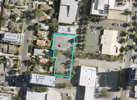
Figure 1 – Aerial of subject
site
There are no existing trees within the northern portion (16
Spring Street), while the southern portion (BHI land) has scattered,
predominately native tree species. Figure 2 shows the location of the
vegetation on site and on abutting properties.


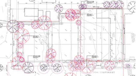
Figure 2 – Survey Plan
– existing vegetation on site and on surrounding properties
Surrounding Context
The subject land, until recently,
was abutted by six residential properties and one medical centre to the
west. The dwellings at 16-22 Wellington have been demolished and this
land is cleared, levelled, fenced and covered with a crush rock seal. The
remaining two dwellings at 10 and 12 Wellington Street and the unoccupied
medical centre (with a sealed car park to the common boundary) have setbacks of
13 metres to 20 metres from the common boundary.
The southern portion of the site is
located within the BHI land and is currently occupied by an at-grade car park.
Abutting the site to the north, at 14 Spring Street, is a 3
storey building used for student accommodation. This building is built
close to the shared boundary and contains balconies facing the site. Further
north at 2-12 Spring Street are facilities and multi deck car parking
associated with the medical precinct and the Epworth hospital.

Figure 3 – Context aerial
photo – surrounding land uses and development (the numbers reflect
other surrounding lots on which approval has been granted for high density
development)
To the west of the site, there are
a number of recent development approvals for residential and/or commercial
buildings of varying heights. These include:
· 12 Wellington Road – approval for a five storey residential
development (WH2011/306). Plans were endorsed on 19/04/2018 and
extension of time granted on 13/06/2019. The proposal comprises of
basement parking constructed along the common boundary (east).
· 12-14 Nelson Road – A 20 storey residential apartment
development.
· 14 Wellington Road – A single storey medical centre with
at-grade car parking to the rear of the site. The medical centre building is a
repurposed dwelling. A Planning application for a 26-storey
mixed-use/residential development has been lodged for this land in association
with the approved redevelopment at 16-22 Wellington Road (WH/2018/856),
· 16-22 Wellington Road– Approved 14-storey residential
development (WH/2016/202),
· 14-22 Wellington Road – WH/2018/856 (current application)
– Use and development of the land for a part 16 and part 18 storey
building, including residential hotel, medical centre, food and drink premises
and dwellings, reduction in car parking requirements and removal of trees. The
proposal seeks removal of all trees onsite including along the eastern boundary
abutting the subject land, and boundary construction.
As shown in Figure
3 (Context aerial photo), the subject land is close to the Box Hill and Epworth
hospitals, BHI (TAFE) and a significant range of restaurants, cafes and other
recreational activities.
The site is within
walking distance to the Box Hill Transit Interchange and the tram terminus on
Whitehorse Road. The site is also within walking distance to the Box Hill
Gardens, Box Hill Hospital, Epworth Eastern Hospital and the core commercial
and retail area of the Box Hill MAC.
Planning
Controls
The subject land is in a Mixed Use
Zone, to the west is Residential Growth Zone, Schedule 3, to the north and to
the north east is Residential Growth Zone, Schedule 3 and Public Use Zone
(3) (Health and Community), and to the south is part Commercial 1, Public Use 2
Zone (Education) and Residential Growth Zone.
Mixed Use Zone
The purpose of the Mixed Use Zone
(MUZ):
Encourages a range of
residential, commercial, industrial and other uses which complement the
mixed-use function of the locality. In addition to provide for housing at
higher densities and to encourage development that responds to the existing or
preferred neighbourhood character of the area.
In accordance with the Mixed Use
Zone requirements the proposed uses and development trigger permission as
follows:
· As the total proposed floor area for Office use is approximately
1,821 square metres (greater than 250 square metres listed in Section 1), a
permit is required for this use.
· Use of the land for a ‘Food and Drink Premises’ is a
Section 1 use provided the leasable floor area does not exceed 150 square
metres. As the proposed Food and Drink Premises within the development
has a total floor area of approximately 386 square metres, planning permission
is required for this use.
· A permit is required for the construction of two or more dwellings
on a lot and residential buildings.
· A permit is required for buildings and works for all permit required
(Section 2) uses.
The zone further requires that any
buildings or works constructed on a lot that abuts land which is in a General
Residential Zone, Neighbourhood Residential Zone, Residential Growth Zone, or
Township Zone must meet the requirements of Clauses 55.03-5 (energy
efficiency), 55.04-1 (side and rear setbacks), 55.04-2 (walls on boundaries),
55.04-3 (daylight to existing windows), 55.04-5 (overshadowing of open space)
and 55.04-6 (overlooking) along that boundary.
Parking Overlay
The land is included in the Parking
Overlay (Schedule 1), Clause 45.09.
The car parking overlay varies the
car parking rates set out in Clause 52.06 (Car Parking) for residential
dwellings and office uses. For all other uses listed in Table 1 of Clause
52.06-5, the number of car parking spaces required for a use shall be
calculated by using the Rate in Column B of that Table (representing a minimum
rate). Applying the car parking overlay rate and the applicable rate under
Clause 52.06-5, the development would generate a car parking requirement of 390
car parking spaces.
The proposal will include the
provision for 369 car parking spaces within five levels of basement. This
will result in a car parking reduction of 21 car spaces, pursuant to Clause
52.06. It is noted that whilst the overall parking reduction is 21 spaces, the
reduction specifically associated with the education use is 74 spaces and that
for the food and drink premises is 9 spaces. The overall parking reduction
offsets this because an additional 62 spaces are proposed to be allocated to
the residential use.
Development Plan Overlay
The purpose of the Development Plan
Overlay is:
· To implement the Municipal Planning Strategy and the Planning Policy
Framework.
· To identify areas which require the form and conditions of future
use and development to be shown on a development plan before a permit can be
granted to use or develop the land.
· To exempt an application from notice and review if it is generally
in accordance with a development plan.
Schedule 8 of the Development Plan
Overlay (DPO8) specifically relates to subject site, 16 Spring Street, Box
Hill. Pursuant to section 1.0 of this Schedule sates that:
1.0 A
permit may be granted before a development plan has been approved for the
following:
· Subdivision
· Minor buildings and works
· Removal or creation of easements or restrictions.
Before granting a permit, the
responsible authority must be satisfied that the permit will not prejudice the
preparation of a Development Plan and the future use and development of the
land in an integrated manner.
It is noted that the Development
Plan was approved by Council on 30 September 2019.
There are no specified conditions
and requirements for permits pursuant to section 2.0 of the overlay Schedule.
Planning permit applications that
are generally in accordance with an approved development plan are exempt from
the notice and review requirement under Section 52 of the Planning and
Environment Act 1987, pursuant to Clause 43.04-3 of the Scheme.
Significant
Landscape Overlay
The Significant Landscape Overlay
– Schedule 9 (SLO9) applies to the northern section of the site, formerly
identified as 16 Spring Street, Box Hill. SLO9 seeks:
‘To encourage the
retention of established and mature trees and to provide for the planting of
new canopy trees.’
The SLO9 requires a permit to
remove protected trees and for buildings and works within four metres of a tree
protected by the SLO9.
For the site, SLO9 only applies to
the northern portion of the site, which contains no existing canopy trees,
whilst the southern portion (land previously zoned Public Use) is not affected
by SLO9.
It is noted that the provisions of
SLO9 extend beyond the subject site and includes Spring Street. The
application seeks permission for the removal of two existing street trees
within Spring Street, road reservation, therefore triggering a planning permit
requirement under SLO9 for the purpose of tree removal.
PROPOSAL
Overview
The proposed development and use,
in summary, comprises the following:
· Development of a 29-storey mixed-use building (excluding services);
comprising a 4-storey podium (non-residential uses to be occupied by Tertiary
Institution (BHI Nurse Training Facility), office, shops, and food and drink
premises);
· 287 Dwellings (1, 2 and 3-bedroom apartments);
· 12 short/medium stay managed studio apartments;
· Five levels of basement car parking providing 369 car parking
spaces.
· Construction
of a private road link from the south end of Spring Street east to Nelson Road
for a distance of about 90 metres.
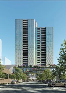
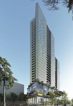
Figure 4 – Artist impression of the development – view from east
and south east
Land uses
The mixed-use proposal will provide
educational, office, retail and high-density residential development in
accordance with the following table:
|
Land Use
|
Floor area/number
|
|
BHI Nurse Training Facility (Tertiary Institution)
|
4,288sqm GFA
|
|
Office
|
1,821sqm NLA
|
|
Shop/Food and Drink Premises
|
386sqm NLA
|
|
Short/Medium Stay Studio Apartments
|
12
|
|
1-Bedroom Apartments (Dwellings)
|
105
|
|
2-Bedroom Apartments (Dwellings)
|
151
|
|
3-Bedroom Apartments (Dwellings)
|
31
|
Nurse Training Facility
This proposed use extends over the
first four floors of the building at the southern end. The facility will cater
for up to 360 nursing students and provide lecture theatres, class rooms,
offices, common spaces and nurse training facilities as required by BHI. Access
to the Nurse Training Facility will occur at the south-east corner of the Site,
connecting into the wider Nelson Road Campus. Vertical transportation is
available by internal elevators, but the design encourages use of the
internal/external wide staircase which forms a feature of the building
frontage. The staircase includes planting as a part of the green building
strategy.
Active Retail Tenancies (Ground
Floor)
The ground floor includes five
small retail tenancies which are to be occupied by cafes, restaurants and small
shops. These commercial premises have floor areas ranging between 64 and 100
square metres. These tenancies will activate the extended Spring Street
frontage with glazed facades and identified areas for footpath trading.
Levels above the podium are
proposed to be developed for a range residential apartment types, separated
into three segments.
Office (Podium Levels 1-3
– Northern Section)
The remainder of the first, second
and third floor space is to be occupied by the commercial office space. The
offices in the northern section of the building are conveniently located close
to the existing medical uses in the surrounding precinct, including Box Hill
Public Hospital, Epworth Private Hospital and eastern Health medical centre.
The office areas on Levels 1-3 are accessed via a separate lobby on the Spring
Street frontage.
Communal
facilities
All residents will have access to a
Gymnasium, Pool and bookable lounge/function facilities located on the northern
section of Level 4. There is an additional communal terrace space on
Level 28 for use by residents of the mid and high rise apartments.
Access, Loading and Parking
Access to the site is provided via
Spring Street which will be extended as a two-lane private road connecting to
Nelson Road through the land at 853 Whitehorse Road, Box Hill (owned by the
BHI).
A 6.1 metre vehicle accessway will
run along the northern boundary of the site, providing access to the basement
parking as well as an at-grade shared loading/waste collection area.
The proposed car parking provision
is 369 spaces, which will be distributed as follows:
· 264
x resident spaces
· 30
x residential visitor spaces
· 34
x education spaces
· 5
x food and drink premises (café) spaces.
· 36
x office spaces
Building design and form
The design provides for a 29-storey
tower, including the four-level podium with a maximum building height of 109.9
metres, measured to the top of the lift core.
Proposed setbacks along Spring
Street frontage vary between 3 metres and 11 metres, above the podium levels.
The curved architectural form is
broken up by landscape terraces at each podium level along the Spring Street
frontage. The revised tower design uses a curved design wall façade
which seeks to reduce the visual massing/volume of the building when viewed from
the east and west.
Tree removal
The proposed development will
comprise of the removal of two protected trees (pursuant to SLO9) along Spring
Street frontage. These Trees are identified as Tree 24 – Liquidambar
styraciflua (Liquidamber) and Tree 25 – Pyrus calleryana
(Ornamental Pear).
Whilst there are other trees on the
land and within proximity to the site (as shown numbered on the image below),
none of these trees are protected by the SLO9, and therefore do not need
permission to remove.


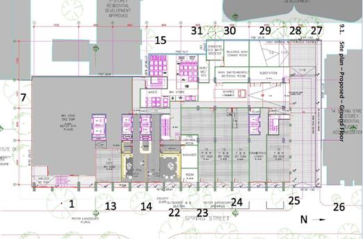
Figure 5 – Protected SLO9
Trees to be removed
CONSULTATION
Public Notice
The application was exempted from
the notice and review requirements pursuant to Clause 43.04-3 - ‘Exemption
form notice and review’ (Development Plan Overlay). Hence the
application was not advertised.
Referrals
External
Integrated Public Transport
Planning
Pursuant to Clause 66.02, an
application to construct a building or to construct or carry out works for a
residential development comprising 60 or more dwellings must be referred to
Public Transport for Victoria. However, Clause 66.02-11, outlines
exemptions from the referral requirement, which includes a development
consistent with an adopted Structure Plan that has been prepared in
consultation with and endorsed by the Head, Transport for Victoria.
The subject site is located within
the Box Hill Transit City Activity Centre Structure Plan, which is a referenced
document within the Whitehorse Planning Scheme. It is submitted that the
proposed development meets the exemption, outlined above, as the Box Hill
Transit City Activity Centre Structure Plan has been prepared in consultation
with and endorsed by the Head, Transport for Victoria.
Internal
Engineering and Environmental
Services Department
Transport Engineer
The proposed plans have been
reviewed by Council’s Transport Engineer, who supports the proposal
subject to conditions. This includes the car parking reduction which is in
accordance with the reduction approved with the endorsed DP.
Waste Engineer
Council’s Waste Management
Engineers have no objection to the proposed development and uses, subject to
conditions on any approval issued.
Assets Engineer
The proposed plans have been reviewed
by Council’s Asset Engineer, who supports the proposal subject to
conditions.
ParksWide
In summary, the below site
assessment and comments, as they relate to the subject land were provided (it
is noted that additional comments were provided by the Parkswide team regarding
trees in the adjoining car park, however these are not able to be considered as
part of this application assessment):
· There are no existing trees at 16 Spring Street.
· There are no trees near common side boundaries to the abutting lots
to the west (facing Wellington Road).
· No objection to the removal of the two street trees, being Tree
24 – Liquidambar styraciflua (Liquidamber) and Tree 25 – Pyrus
calleryana (Ornamental Pear), subject to the appropriate payment of tree amenity
value.
ESD Advisor
The Development Plan has been
reviewed by Council’s ESD Officer who found that the information could
satisfy the requirements of the DPO, subject to amended plans. Amended
plans are required to comply with ESD policy at Clause 22.10 of the Planning
Scheme.
Urban Design
The application was referred to
Council’s Consultant Urban Designer (MGS Architects) who has raised
concerns relating to the overall height, and in particular how the proposed
design does not provide for appropriate ‘graduation’ to its
surrounds. The following are extracts of some of the key commentary:
· ……The development should scale down substantially more
from its tallest southernmost form embedded in the campus SE corner stepping
down to the north and further to the north and north east. Scale of development
should not result in impacts in my view on the primary pedestrian walk of
Nelson Road before 2pm. The transition to adjoining development of 14 levels to
the northwest should be substantially greater as a step in my view a midpoint
between this scale and the recalibrated effective 29 levels rather than the
expanded scale as currently proposed.
· …….The proposal exceeds the design intent of this
provision and hence the proposal’s offsite impact should be assessed.
· The proposal represents a minimum 25-30% exceedance of preferred
scale with the balcony overhangs further exacerbating the impact and visual
bulk on the public realm, diminish the perceived width of the public realm of
Spring Street and the ability for street trees and canopies to contribute to
enhancing the public realm and mitigating the impacts.
· …… No reason why commercially beneficial development
should be supported in combined with greater height.
· ……Given the narrow nature of the street, the increased
need for pedestrian space and the proposed height, a minimum 3m should be
provided to Spring Street to expand the pedestrian and landscape zone and
ensure the terrace elements do not overhang the boundary.
· The building should be setback to ensure that tree canopy zones,
footpath areas and enhanced capacity are unhindered by new development.
Officers acknowledge the advice
provided by its urban Design consultant, as many relevant points have been
raised in regards to the building interfaces with surrounding land uses and
properties. In this context however, the approval of the Development Plan
Overlay constrains officers’ ability to assess the proposal beyond
those quantifiable provisions of the endorsed DP. A comparison response
against the endorsed DP will be offered in the later section of this report.
Landscape Architect
The proposal has been reviewed by
Council’s Landscape Architect. It is generally considered that the
proposed landscape plan is well considered and acceptable, subject to
conditions.
Leisure and Recreation
Council’s Leisure and
Recreation Department reviewed the Community Infrastructure Assessment where it
relates to public open space / recreation. The Development Plan incorporates
the findings of the Whitehorse Open Space Strategy (the WOSS). It is
concluded that the increase in population may have an impact on the use of
existing sporting reserves.
Community Development
The Development Plan has been
reviewed by Council’s Community Development Department.
The review considered the potential
projected increase in demand from the proposed development on sporting
clubs/facilities (including athletics, Lacrosse, rugby union and hockey), and
other education, health and community services.
Although overall projected growth
for the entire Box Hill MAC is significant, the proposed dwelling yield for the
subject site will generate very moderate additional demands on existing
community infrastructure such as meeting halls and facilities. Without a
Development Contributions Plan Overlay or similar precedent involving the
collection of developer contributions towards community infrastructure in the
Box Hill area, it is difficult to request additional contributions.
Furthermore, there are no development contribution requirements currently
listed under the Planning Scheme.
As a result of the Community
Infrastructure Assessment, the Development Plan does include some community
facilities such as meeting rooms to service the needs of its residents, its new
high quality nursing training facility, the medical centre, gym and pool.
It is also noted that upon
subdivision of the building, a mandatory minimum 4% Public Open Space
contribution will be required to be paid.
DISCUSSION
Consistency with State and Local
Planning Policies
The subject site
is zoned Mixed Use Zone.
As the subject
land is also within the Box Hill Structure Plan and in a Major Development
precinct, much larger and intensive developments can be considered with greater
building heights. The proposal complies with this strategic direction by
continuing to provide a range of residential and commercial uses for the site
in a more intensive form to facilitate greater residential density and
employment opportunities in the area.
The site is close
to public transport and road network systems supporting cars, walking and
cycling. State policy encourages the intensification of employment generating
uses in areas with these locational characteristics close to where people live
(clause 11.03-1S Activity Centres and Clause 15.01-4R Healthy Neighbourhoods
– Metropolitan Melbourne).
State planning
policy generally supports the subject site as a significant strategic
redevelopment opportunity to deliver higher density residential uses and
complementary commercial activity. This is justified given the
site’s location within the Box Hill Metropolitan Activity Centre, in
close proximity to Whitehorse Road to the south and its proximity to a broad
range of urban infrastructure including public transport services, employment opportunities
and commercial facilities.
Similarly, Local
Planning Policy identifies the vibrant and mixed use nature of activity centres
as an important attribute of the municipality and seeks to encourage their long
term viability through development and land uses that contribute to the
adaptation, redevelopment and economic growth. Clause 21.07-Economic
Development, also seeks to increase the number and diversity of employment
opportunities, specifically identifying retail, offices and other commercial
activities as an area where opportunities have been created, particularly in
redevelopment sites. The proposal complies with this policy and achieves these
goals.
The proposed
density of the development is consistent with both State and Local Policies
such as Clauses 16.01-1S Integrated Housing, 17.01-1R Diversified Economy
– Metropolitan Melbourne, 18.01-1S-Land Use and Transport Planning, which
encourages concentration of development and employment opportunities in and
around activity centres and intensifying development on sites well connected to
public transport. This enables more efficient use of existing infrastructure.
Overall, there is
clear policy support for intensification of the site and broader Box Hill MAC.
The proposed re-development for a 29 storey building at the scale proposed is
considered to have strategic support.
It is also noted
that the Mixed Use Zone falls under the residential zoning category. This zone
supports a range of other uses, including commercial uses. In this context the Education
Centre, offices and shops are seen as enhancing services for the site and
surrounding land uses/occupants.
Use
The mix of education, office and
shop uses will play a legitimate role in meeting the needs of the area in this
respect and providing seven days a week activation of the area. Generally
offices or education uses are closed after hours and on weekends and can lead
to inactivity of an area outside of business hours.
Regarding the appropriateness of
the proposed uses, it is considered that there is support for where a use can
demonstrate that the scale of an operation would not result in unreasonable
impacts to the surrounding area or erosion of the primary purpose of the Mixed
Use Zone. This consideration is relevant in terms of the objective of the
Mixed Use Zone: to provide for a range of residential, commercial,
industrial and other uses which complement the mixed-use function of the
locality.
The site is located within a
Metropolitan Activity Centre (MAC) which is of importance not only to the
municipality, but also to the broader metropolitan region given its capacity
for change and connections to other activity centres, residential areas and
transport. The proposal will facilitate growth in employment base, with
the education centre, office and shop uses further supporting this by providing
additional employment opportunities. Additionally the shop/food and
beverages will provide venues where local workers, students and local residents
can obtain food and drinks. On weekends, there is an expectation that
mixed use buildings are active and provide for visitors and local residents
alike.
In relation to the education
component, by reference to Clause 19.02-2S, one of the objective of this clause
sates:
· To assist the integration of education facilities with local and
regional communities.
Key strategies to achieve this
include, to:
· Locate secondary and tertiary education facilities in designated
education precincts and areas which are highly accessible to public transport.
· Locate tertiary education facilities within or adjacent to activity
centres.
· Ensure areas near to education facilities, adjoining streets and
accessways are designed to encourage safe bicycle and pedestrian access.
The objectives outlined above, are
given further strength through references in Clause 22.07 Box Hill Metropolitan
Activity Centre, which outlines the significance of the Box Hill MAC and
provides specific objectives on achieving appropriate outcomes in each of the
designated precincts within Box Hill. This site sits within the Hospital and
Western TAFE Precinct, and the proposal, from a broader strategic land use
perspective, is well positioned.
Design and Built Form
Overview
Since the inception of the Box Hill
Structure Plan, significant redevelopment has occurred in the Box Hill Major
Development Precinct (as defined by the Structure Plan), in the vicinity of
arterial roads, the transport interchange and the commercial centre. Specific
urban design guidelines for residential growth areas have not been formally
adopted or incorporated in the Planning Scheme at this time so each planning
assessment is assessed in terms of the specific site circumstance and the
general design response in the evolving context of the area.
Within the Box Hill Structure Plan,
the site is located in Built Form Precinct F (Major Development
Precinct). Precinct F is the only precinct within the Box Hill Structure
Plan where no specific preferred or maximum height limit applies. The site is
located within an area undergoing significant transformation. In this
precinct taller buildings are permitted, enabling increased density. It is
expected that this will continue to be developed with multi-level mixed use
buildings contributing to the economic viability of the centre. It is
acknowledged that the building will be significantly larger than other
buildings currently existing or approved, and whilst Council expressed concerns
over the building height during the planning scheme amendment process, the DPO
was introduced allowing buildings up to 29 storeys. This provides limited
capacity on this site for officers to argue for less prominent building
heights. Whilst initially this development will be prominent, this will lessen
over time as surrounding sites are also developed.
Compliance with approved
Development Plan
Section 2.0 of the Development Plan
Overlay – Schedule 8, provides no additional conditions or assessment
requirements beyond the endorsed DP. Hence, the following is a comparison
assessment of the proposal plans against the endorsed DP.
The following comparison of the
proposal against the endorsed DP is grouped into similar themes, where
appropriate.
Height and Graduation of built
form
The 29-storey tower is set back
between 3 and 11 metres from the Spring Street frontage. The
proposed building totals 109.5m in overall height, including roof services.
The proposal is generally
consistent with the building envelope as endorsed under the DP with minor
non-compliances in terms of setbacks along the northern and eastern elevations
(mainly relating to the tower element that is above the podium levels).
Notwithstanding this, the level of noncompliance is only minor, varying between
0.5 to 0.8 metres. This can be addressed by way of permit conditions.
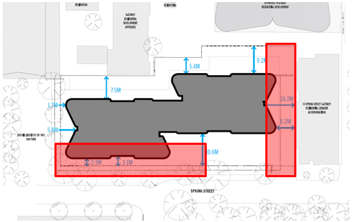

Figure
6 – areas of non-compliance with setbacks (DPO requirements) to be
addressed by way of permit conditions.
Shadow impacts
The submitted shadow diagrams
suggest that there are no shadow impacts along the pedestrian walkway, along
both Nelson Road and Wellington Road (refer to Figure 7, below). The only
additional overshadowing along the pedestrian walk ways will occur between the
hours of 2 -3pm, affecting Nelson Road. This is considered acceptable, and
further is consistent with the endorsed DP.
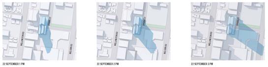
Figure 7 – Shadow diagram
for period between 10am - 3pm
Car parking and bicycle parking
Section 3 of the endorsed Transport
Impact Assessment report (DP endorsed package), specified minimum numbers of
car parking and bicycle parking requirements for the development proposal. This
stipulated that any development is to provide 369 car parking spaces across
five basement levels and 120 secured bicycle parking spaces within basement
level 1.
The current proposal will provide
for full compliance with the above car parking and bicycle parking provisions
outlined above and is therefore considered consistent with the endorsed DP.
This is supported by Council’s Transport Engineers.
|
Land Use
|
Number /
Area
|
Statutory Parking Rate
|
Number required
|
Proposed allocation
|
|
Dwellings
|
|
· 1 bedroom
|
117
|
0.5 spaces per dwelling
|
58
|
58
|
|
· 2 bedroom
|
151
|
0.75 spaces per dwelling
|
113
|
113
|
|
· 3 bedroom
|
31
|
1 space per dwelling
|
31
|
31
|
|
· Visitor parking
(dwellings)
|
299
|
0.2 spaces for the first 5
dwellings plus 0.1 spaces to each subsequent dwelling
|
30
|
30
|
|
· Unallocated residential spaces
|
62
|
|
Food and drink Premises
|
412m2
|
3.5 spaces per 100m2 of
net floor area
|
14
|
5
|
|
Office
|
1821m2
|
2.0 spaces per 100m2 of
net floor area
|
36
|
36
|
|
Education Centre
|
4288m2/
360 Students
|
0.3 spaces to each student
that is part of the maximum number of students on the site at any time
|
108
|
34
|
|
|
|
Total
|
390
|
369
|
Table 1 – Statutory parking
requirement and proposed allocations
A total of 120 bicycle parking
spaces are proposed, exceeding the required 118 spaces, therefore satisfying
the bicycle parking requirements for the site.
Additionally, the provision of
bicycle facilities (in the form of showers and change rooms) meets the
requirements of the Planning Scheme, and is therefore considered appropriate.
The required shower and change room facilities are provided in the Level B1 End
of Trip Facilities area.
Public Realm
A significant consideration in
assessing how and if a building is appropriate to its context, is its
interfaces to public spaces and how they enhance the visual and social
experience of the user. In this respect, the proposal represents an appropriate
response to the streetscape, public realm quality and perceived safety.
The activation of Spring Street and
the BHI Nelson Campus is a key element of the proposal. The design seeks to
centralise activity along Spring Street by providing primary access routes and
active retail uses along this frontage. As a part of the design inception, a
master planning exercise was undertaken for the site and the broader BHI Nelson
campus. The exercise identified opportunities for a potential university
green/square to the south of the site, at the centre of the BHI Nelson Campus.
The design for this site has incorporated opportunities to allow these elements
to be included in the future development of the precinct.
The ground floor has been designed
to activate the street through a number of retail tenancies that front Spring
Street. While a small extent of servicing fronts the street, the majority
(including substation) is concealed along the northern laneway area. Through
the activation of the ground floor, the building will provide interaction at
street level where there currently is none. The proposal will activate Spring
Street as a result of the proposed café and open paved and landscaped
area in the frontage, bringing foot traffic from the BHI, medical uses and
general passers-by. This is a good response from an urban design
perspective.
The design includes landscaped
terraces that step up the podium with the staircase; designed to enhance the
building and provide a green connection with Box Hill Gardens and Kingsley
Gardens. The Spring Street footpath is also proposed to be widened in front of
the building to enhance pedestrian amenity (subject to Council approval).
Adding to the pedestrian
connections enjoyed by the site, the proposal includes construction of a new
private road connecting the BHI land, extending from Spring Street to Nelson
Road, improving local traffic circulation.
Above ground floor, a variety of
commercial uses and protruding landscape terraces are proposed in the podium
which will provide passive surveillance. Roof top services are proposed to be
concealed by the inclusion of a parapet that extends upwards as a design
feature from the levels below.
By focusing activity along the
Spring Street frontage, the design provides passive surveillance for Spring
Street and BHI Nelson Campus common areas and develops a sense of activity and
vitality in a previously underutilised area of the Box Hill MAC. This is
demonstrated, albeit in an ‘artist impression’, in the image below.
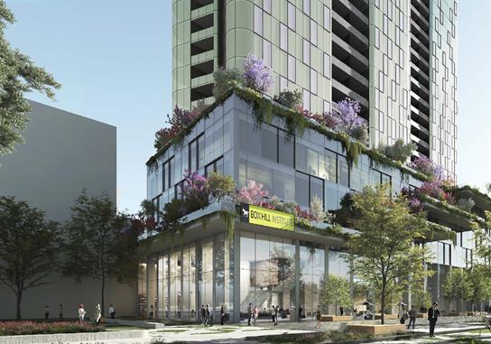
Figure 8 – Artist impression
of ground level, providing street activation through visual and use activities
Overall, the development will
provide for significant public realm improvements, notably to the accessibility
and walkability of the surrounding area, in turn benefiting the community as a
whole. This is an important consideration in assessing the interaction of the
building and its uses to the surrounding activity centre and its impact on the
overall amenity of the public realm.
Tree removal
As mentioned earlier, the
application seeks the removal two trees, being tree 24 – Liquidambar
styraciflua (Liquidamber) and tree 25 – Pyrus calleryana
(Ornamental Pear) - both street trees - located within Spring Street road
reserve. The removal of these two trees is consistent with the endorsed
Landscape and Public Realm Concept and Sign and Line Marking Plan, forming part
of the endorsed DP.
It is further noted that
Council’s ParksWide Arborist has reviewed the proposal and provided no
objection to the removal of the two trees in question, subject to amenity value
payment. The requirement for appropriate amenity value payment can be
incorporated as part of permit note on any approval granted.
Amenity
As there are no requirements listed
in the Planning Scheme specifying building heights and setbacks in this
Precinct, overshadowing, overlooking and building bulk become central
considerations. Building bulk and overshadowing has been discussed above,
with consideration of overlooking and overshadowing of abutting properties
addressed below.
In terms of light and shade to the
public realm, due to the orientation of the site, the proposal will result in additional
shadows to the rear of five lots in the Residential Growth Zone (west, facing
Wellington Road), the BHI car park to the south of the site and the car park at
the rear of 17-23 Nelson Road. However it is concluded that the extent of
overshadowing will be at an acceptable level.
It is acknowledged that additional
shadow will be cast upon both properties to the west and will partly overshadow
the eastern side of the pedestrian path, along Wellington Road. However,
the extent of overshowing is limited to early morning and diminishes between
10-11am. Therefore it is considered that the existing residential dwellings to
the west would still receive adequate sunlight throughout the day.
Planning officers accept the
argument that redevelopment in a “Major Development Precinct” will
result in some additional overshadowing which occurs as development of this
area intensifies.
In accordance Clause 32.04-10 of
the Mixed Use Zone, the proposed development must also meet the requirements of
Clauses 55.03-5 (Energy efficiency), 55.04-1 (Side and rear setbacks), 55.04-2
(Walls on boundary), 55.04-3 (Daylight to existing habitable room windows),
55.04-5 (Overshadowing of open space) and 55.04-6 (Overlooking) along that
boundary. The site abuts RGZ land to the west. Therefore an assessment of the
proposal against the requirements of Clause 55 is required and can be
summarised as follows:
Clause 55.03-5
(Energy efficiency – Standard B10)
The application
was referred to Council’s ESD officer who has reviewed the plans and
provided no objections to the proposal, subject to conditions.
Clause 55.04-1
(side and rear setbacks – Standard B17)
A variation is
necessary to the side setbacks along the western boundary. It is noted
that lower scale buildings currently exist in this interface with the
site. However, these sites have been identified for higher density
development as they are situated/identified within Precinct F – Major
Development Precinct under Clause 22.07 of the Whitehorse Planning Scheme.
Clause 55.04-2
(walls on boundaries – Standard B18)
The proposed
podium will present a six metre wall height along the entire western
boundary. Whilst this is not complaint with Standard B18, this is a
common design character of large scale high rise development that is generally
unavoidable. Further, whilst the MUZ requires assessment against particular
Clause 55 standards, the existence of a Development Plan creates the
expectations for building wall heights as the two provisions clearly compete
within one another. It is noted however, that there is a consistent
character of boundary-to-boundary development with all of the abutting sites
and/or recently approved development, having high site coverage and high walls
along the boundaries with minimal openings. The proposal will continue
this character of height and site coverage, but will achieve improved visual
permeability.
Clause 55.04-3
(daylight to existing windows – Standard B19)
The proposal
complies with this standard as the proposal will achieve a minimum setback of
at least 4.5 metres, (for all walls above 6 metres in height) from the abutting
properties to the west, ensuring that a minimum light court area of 3 square
metres is achieved for the existing west-facing windows of the adjoining
property at 5 Elland Avenue.
Clause 55.04-5
(overshadowing of open spaces – Standard B21)
A variation is
required. Shadow plans provided by the applicant show an increase in
shadowing to the abutting residential properties to the west, up to 12pm.
It is acknowledged that there will be direct overshadowing impacts on the
existing private open space areas located west and whilst not an ideal outcome,
is considered reasonable as the building design and setbacks still
ensure a minimum of 4 hours of sunlight access between the hours of 9 am to 1
pm.
The only
alternative to achieve full compliance is to reduce the height of the eastern
building substantially from 35 metres to approximately 7 metres (double storey
height). The DPO as the guiding planning scheme tool for this site,
provides overriding support for a building up to 29 metres and as such,
officers have little capacity to argue for wall heights that are significantly
less than this.
Clause 55.04-6
(overlooking – Standard B22)
An assessment of
the proposed plans and elevations suggest that, while there are some screening
measures intended to limit views into the rear secluded private open space
areas of the adjoining properties to the west, the response by the proposed
development is insufficient. This can be addressed by way of permit
conditions, should one be issued, requiring compliance with Standard B22.
Clause 58 – Apartment
Development
Clause 58 (Apartment Developments),
offers an effective tool to consider on and offsite amenity impacts.
Planning officers have assessed the proposal against the requirements of Clause
58 and the proposal comply with all relevant objectives and standards, with the
exception of Standard D10 and D19 which are outlined below:
Standard D10 (Landscaping)
There are no areas of deep soil in
the proposal and this reduces the opportunity to provide any new tree planting
on site. The proposed additional new tree planting in the road
reservation is supported in principle by Council’s Parkswide
Department. It is noted that these trees will be planted along both the
Spring Street frontage and the proposed new road extension (connecting back to
Nelson Road).
Standard D19 (Private open
space)
Ratios of private open space in
relation to apartment sizes/numbers of bedrooms is not compliant for a number
of dwellings. The table listed under D19 specifies that the following
should be achieved: one bedroom - 8 square metres with a minimum width of 1.8
metres; two bedrooms - 8 square metres with a minimum width of 2 metres; and
three bedrooms - 12 square metres with a minimum dimension of 2.4 metres.
Whilst the proposal has achieved compliance with minimum area requirements, it
has failed to achieve the minimum width requirements associated with all
apartments with curved balconies. This can be addressed by way of permit
conditions of any approval granted.
CONCLUSION
The proposal for the construction
of a 29 storey mixed use building with five basement levels, comprising of 299
dwellings (12 of which are short term stay apartments) together with the use of
the land for used for the purposes of Education Centre (Nurse training
facility), Offices, Shops, Food and Drink premises, Accommodation, reduction to
the car parking requirement and removal of protected trees (SLO9) is an
acceptable response that satisfies the relevant provisions contained within the
Whitehorse Planning Scheme, including the State and Local Planning Policies,
the Mixed Use Zone, Clause 43.04 Development Plan Overlay, Clause 58, Apartment
Development and strategic policies, particularly the Box Hill Structure
Plan.
It is recommended that the
application should be approved subject to the conditions outlined above.
Attachment
1 Decision Plans 
2 Landscape Plan 
Ordinary Council Minutes 16
March 2020
9.1.2 199
Canterbury Road, Blackburn (LOT 1 LP 114506) Development of the land for five
(5) double-storey dwellings, including associated SLO2 tree removal and
buildings and works within 4 metres of SLO2 trees, and alteration of access to
a Road Zone Category 1.
FILE NUMBER: WH/2019/2
ATTACHMENT
SUMMARY
This application was advertised, and a total of 23
objections were received. The objections raised issues with neighbourhood
character, inconsistencies with the Significant Landscape Overlay, Schedule 2,
tree removal and lack of landscaping opportunity. A Consultation Forum was held
on 11 December, 2019, chaired by Councillor Massoud, at which the
issues were explored, however no resolution was reached between the parties.
This report assesses the application against the relevant provisions of the
Whitehorse Planning Scheme, as well as the objector concerns. It is
recommended that the application be supported, subject to conditions.
|
RECOMMENDATION
That Council:
A. Being the Responsible Authority, having
caused Application WH/2019/2 for 199 Canterbury Road, BLACKBURN (LOT 1 LP
114506) to be advertised and having received and noted the objections is of
the opinion that the granting of a Planning Permit for the Development of the
land for five (5) double-storey dwellings, including associated SLO2 tree
removal and buildings and works within 4 metres of SLO2 trees, and alteration
of access to a Road Zone Category 1 is acceptable and should not unreasonably
impact the amenity of adjacent properties.
1. Issue a Notice of Decision to Grant a Permit under the Whitehorse
Planning Scheme to the land described as 199 Canterbury Road, BLACKBURN (LOT
1 LP 114506) for the Development of the land for five (5) double-storey
dwellings, including associated SLO2 tree removal and buildings and works
within 4 metres of SLO2 trees, and alteration of access to a Road Zone
Category 1, subject to the following conditions: Before
the development starts, or vegetation removed, amended plans must be
submitted to and approved by the Responsible Authority in a digital
format. When approved, the plans will be endorsed and will then form
part of the permit. The plans must be drawn to scale, and be generally
in accordance with the plans submitted with the application but modified to
show:
a) Development
and landscape plans updated to show:
i. Retention
of the existing cyclone wire fence on the rear boundary with the Masons Road
Reserve.
ii. Retention
of Trees 19 and 20.
iii. Removal
of references to the previous six dwelling proposal from the plans.
iv. Landscape
plan updated in accordance with Plan Revision D dated December, 2019.
b) The
locations of the Tree Protection Zones described in condition 5, with all
nominated trees clearly identified and numbered on both site and landscape
plans, and the requirements of conditions 5 and 6 to be annotated on the
development and landscape plans.
c) The
location of all service trenches to serve the dwellings (for example: gas,
water, electricity, stormwater, sewerage, telecommunications), including the
extent of trenching required in easements over adjoining lots (if any) and the
locations of protected trees within 4 metres of these trenches (if
any). The service trenches must be located and dug (including boring or
hand digging) to ensure that protected trees are not damaged, to the
satisfaction of the Responsible Authority.
d) The
following modifications to upper levels to reduce the prominence of the
buildings:
i. The
removal of bedroom 4 to Dwelling 4.
ii. The
Dwelling 3 ensuite to the master bedroom to be reduced in size so that it
aligns with the walk-in-robe.
iii. The
removal of bedroom 4 to Dwelling 2.
This must occur without
any modification to other nominated setbacks.
e) The
vehicle crossover to be drawn to scale and dimensioned. The vehicle
crossover must not be in conflict with any assets and must be constructed at
least 1 metre from both stormwater pits in Canterbury Road.
f) The
landscape area outside the entry to Dwelling 1 to be reduced by 1 metre to
improve vehicle access.
g) Ground
floor plans to nominate location of any retaining walls to support site
cuts.
h) The
storage shed to be located outside of the TPZ of Tree 21.
i) Development
plans to reflect all sustainability features indicated in the amended
Sustainable Design Assessment (SDA) required by condition 13. Where features
cannot be visually shown, include a notes table providing details of the
requirements (i.e. energy and water efficiency ratings for heating/cooling
systems and plumbing fixtures, etc.). The plans are to be generally in
accordance with the plans submitted indicating:
i. Annotations that the 3,000 litre
rainwater tanks are allocated for reuse/retention purposes, exclude any
volume allocated for detention, and will be connected to all toilet flushing,
laundry systems and irrigation areas.
ii. Either:
A
minimum of 50% of the driveway area to constitute permeable paving, annotated
on Development and Landscape Plans; or
A
minimum of 33% of the driveway area to be directed to a minimum 5m2
raingarden. Landscape Plans must reflect a cross section of the
raingarden, including a submerged zone for efficiency and maintainability
purposes, as well as, proposed connection to drainage systems directed to the
legal point of discharge. Suitable species must also be specified on
the Landscape Plan Planting Schedule.
iii. All operable windows, doors and vents in
elevation drawings.
iv. Double glazing annotated to all living and bedroom
area windows on elevation drawings.
v. Where measures cannot be visually shown,
include a notes table or ‘ESD Schedule’ providing details of the
ESD features and requirements (i.e. dwelling star ratings, energy and water
efficiency ratings for heating/cooling systems and plumbing fittings and
fixtures, etc.).
j) The
following corrections to plans:
i. The setback between the living area of
Dwelling 1 and the west boundary to be correctly nominated.
ii. The elevation plans to correctly annotate
the upper level windows of Dwelling 5 to match the window layout shown on the
upper level floor plans.
iii. The notation of the ‘6 cubic storage
shed’ adjacent to the laundry door to the east elevation of Dwelling 3
to be deleted.
k) The
cladding colours and materials schedule updated to provide:
i. A light coloured roof.
ii. All obscured glazing be manufactured
obscured glass.
l) Landscape
plan amended to reflect the alterations required above and to replace two
proposed Acacia implexa trees (south of garage 1 and east of garage 5) with
Eucalyptus radiata, and the planting of one additional Eucalyptus radiata
tree within the Dwelling 5 frontage, clear of the canopies of existing trees.
All of
the above must be to the satisfaction of the Responsible Authority. Once
approved these plans become the endorsed plans of this permit.
2. The
layout of the site and the size, design and location of the buildings and
works permitted must always accord with the endorsed plan and must not be
altered or modified without the further written consent of the Responsible
Authority.
Landscaping and Tree
Protection
3. Except
with the prior written consent of the Responsible Authority, all tree
planting and landscaping works as shown on the endorsed plans must be
undertaken and completed prior to the occupation of the development, to the
satisfaction of the Responsible Authority.
4. The
garden areas shown on the endorsed plan must only be used as gardens and must
be maintained in a proper, tidy and healthy condition to the satisfaction of
the Responsible Authority. Should any tree or shrub be removed or
destroyed it may be required to be replaced by a tree or shrub of similar
size and variety.
5. Prior
to commencement of any building or demolition works on the land, a Tree
Protection Zones (TPZs) must be established on the subject site and nature
strip and maintained during, and until completion of, all buildings and works
including landscaping, around the following trees in accordance with the
distances and measures specified below, to the satisfaction of the
Responsible Authority:
a) Tree
Protection Zone distances:
i. Tree
1 (Lophostemon confertus) – 3.2 metre radius from the centre of the
tree base.
ii. Tree
2 (Eucalyptus leucoxylon) – 4.0 metre radius from the centre of the
tree base.
iii. Tree
3 (Pittosporum undulatum) – 2.0 metre radius from the centre of the
tree base.
iv. Tree
5 (Syzygium paniculatum) – 3.7 metre radius from the centre of the tree
base.
v. Tree
7 (Melaleuca linariifolia) – 2.4 metre radius from the centre of the
tree base.
vi. Tree
9 (Eucalyptus ovata) – 7.9 metre radius from the centre of the tree
base.
vii. Tree
10 (Grevillea robusta) – 5.1 metre radius from the centre of the tree
base.
viii. Tree
13 (Eucalyptus cephalocarpa) – 5.8 metre radius from the centre of the
tree base.
ix. Tree
14 (Eucalyptus ovata) – 3.7 metre radius from the centre of the tree
base.
x. Tree
15 (Eucalyptus ovata) – 6.4 metre radius from the centre of the tree
base.
xi. Tree
16 (Eucalyptus ovata) – 5.7 metre radius from the centre of the tree
base.
xii. Tree
17 (Eucalyptus ovata) – 5.6 metre radius from the centre of the tree
base.
xiii. Tree
19 (Eucalyptus ovata) – 4.5 metre radius from the centre of the tree
base.
xiv. Tree
20 (Eucalyptus ovata) – 4.6 metre radius from the centre of the tree
base.
xv. Tree
21 (Eucalyptus ovata) – 5.6 metre radius from the centre of the tree
base.
xvi. Tree
25 (Eucalyptus sp.) – 2.0 metre radius from the centre of the tree
base.
xvii. Tree
26 (dead tree) – 2.9 metre radius from the centre of the tree base.
xviii.Tree
27 (Melaleuca linariifolia) – 2.9 metre radius from the centre of the
tree base.
xix. Tree
28 (Eucalyptus botryoides) – 3.3 metre radius from the centre of the
tree base.
xx. Tree
29 (Acacia floribunda) – 2.0 metre radius from the centre of the tree
base.
xxi. Tree
32 (Corymbia citriodora) – 9.0 metre radius from the centre of the tree
base.
b) Tree
Protection Zone measures are to be established in accordance with Australian
Standard 4970-2009 and are to include the following:
i. Erection
of solid chain mesh or similar type fencing at a minimum height of 1.8 metres
in height held in place with concrete feet.
ii. Signage
placed around the outer edge of perimeter the fencing identifying the area as
a TPZ. The signage should be visible from within the development, with the
lettering complying with AS 1319.
iii. Mulch
across the surface of the TPZ to a depth of 100mm and undertake supplementary
provide watering/irrigation within the TPZ, prior and during any works
performed.
iv. No
excavation, constructions works or activities, grade changes, surface
treatments or storage of materials of any kind are permitted within the TPZ
unless otherwise approved within this permit or further approved in writing
by the Responsible Authority.
v. All
supports and bracing should be outside the TPZ and any excavation for
supports or bracing should avoid damaging roots where possible.
vi. No
trenching is allowed within the TPZ for the installation of utility services
unless tree sensitive installation methods such as boring have been approved
by the Responsible Authority.
vii. Where
construction is approved within the TPZ, fencing and mulching should be
placed at the outer point of the construction area.
viii. Where
there are approved works within the TPZ, it may only be reduced to the
required amount by an authorized person only during approved construction
within the TPZ, and must be restored in accordance with the above
requirements at all other times.
6. During
construction of any buildings, or during other works, the following tree
protection requirements are to be adhered to, to the satisfaction of the
Responsible Authority:
a) A
project arborist must be appointed by the applicant or builder. Project
arborist qualifications must read ‘Arboriculture’ for example
‘Diploma in Horticulture (Arboriculture)’. The project arborist
must have a minimum Diploma qualification in arboriculture to be appointed as
the project arborist.
b) The
Project Arborist must supervise all approved works within the TPZs of Trees
1, 2, 3, 5, 7, 8, 9, 10, 13, 14, 15, 16, 17, 19, 20, 21, 25, 26, 27, 28, 29
and 32. The project Arborist must ensure that all buildings and works
(including site demolition) within the TPZs of the trees do not adversely
impact their health or stability now or into the future.
c) All
buildings and works for the demolition of the site and construction of the
development (as shown on the endorsed plans) must not alter the existing
ground level or topography of the land within greater than 10% of the TPZs of
Trees 1, 2, 3, 5, 7, 8, 9, 10, 13, 14, 15, 16, 17, 19, 20, 21, 25, 26, 27,
28, 29 and 32.
d) For
Trees 1, 2, 3, 5, 7, 8, 9, 10, 13, 14, 15, 16, 17, 19, 20, 21, 25, 26, 27,
28, 29 and 32 no roots greater than 40mm in diameter are to be cut or damaged
during any part of the construction process.
e) The
project arborist and builder must ensure that TPZ Fencing Conditions are
being adhered to throughout the entire building process, including site
demolition, levelling and landscape works.
f) The
pruning of Tree 29 is to be undertaken by Council’s Parkswide
Department.
g) Any
tree pruning is to conform to AS4373-2007 Pruning of Amenity Trees and the
work is to be performed by a suitably qualified arborist (AQF Level 3,
minimum).
7. Only
the following trees are allowed to be removed or destroyed:
Tree
4 (Eucalyptus melliodora), Tree 22 (Ulmus glabra ‘Lutescens’),
and Tree 23 (Morus nigra).
8. No
other vegetation on site, shown as an existing tree or shrub on the endorsed
plan, shall be destroyed, felled, lopped or uprooted without the written
consent of the Responsible Authority (other than in accordance with a Notice
given pursuant to the Local Government Act or vegetation with a trunk
circumference of less than 0.5 metre when measured at a point 1 metre above
ground level). The on-going maintenance of the retained and planted
trees must be undertaken to the satisfaction of the Responsible Authority. If
any planted trees die or are removed, they must be replaced within two months
and maintained to the satisfaction of the Responsible Authority.
9. Council's
Planning Enforcement officer must be advised of the completion of all tree
planting required by this permit so that a site inspection can be carried
out. A further inspection may be carried out 6 months after the
completion of the landscaping to ensure that species has been adequately
maintained.
Site Layout and Services
10. The
development must be provided with external lighting capable of illuminating
access to each garage and car parking space. Lighting must be located,
directed and shielded and of limited intensity that no nuisance or loss of
amenity is caused to any person within and beyond the site.
11. All
treatments to prevent overlooking must not include ‘Translucent
film’ on windows and must be in accordance with Standard B22 of Clause
55.
12. Prior
to the occupation of the development, all boundary walls must be constructed,
cleaned and finished to the satisfaction of the Responsible Authority.
Environmentally
Sustainable Design
13. Prior
to the commencement of any buildings or demolition works, an updated
Sustainable Design Assessment (SDA) must be submitted to and approved by the
Responsible Authority. This SDA must be generally in accordance with
the SDA submitted with the application, but amended to include the following
changes:
i. A STORM Assessment or equivalent
addressing stormwater quality performance, in addition to ensuring that the
Responsible Authority’s collective integrated water management
expectations and requirements pursuant to Clauses 34 and 44 of the State
Environment Protection Policy (Waters), are satisfied which includes
rainwater tanks of a minimum 3,000 litre capacity for retention purposes for
each dwelling.
ii. Rainwater tanks connected to all toilet
flushing, laundry systems and irrigation areas.
iii. A commitment that either:
a. A
minimum of 50% of the driveway area will constitute permeable paving; or
b. A minimum of 33% of the driveway area will be
directed to a minimum 5 m2 raingarden.
iv. A complete, published BESS Report, with an
acceptable overall score of at least 50% and also which meets the
‘pass’ marks in the categories of Water, Energy Stormwater and
Indoor Environment Quality (IEQ) to the satisfaction of the Responsible
Authority.
v. A commitment that the development will
achieve a minimum average NatHERS Energy Efficiency ratings of 6.5 stars
reflecting best practice energy efficiency and thermal comfort.
vi. Heating and cooling systems include a minimum 4
star energy efficiency rating.
vii. Hot water systems include a minimum 5 star energy
efficiency rating.
viii. Water efficient fixtures and fittings including 4 star WELS
toilets, 5 star WELS taps and 3 star WELS showerheads (≤ 7.5 L/min).
ix. Double glazing used to all living areas and
bedrooms.
x. Provision for secure bicycle parking for 5
individuals.
Once submitted and
approved to the satisfaction of the Responsible Authority, the SDA will form
part of the endorsed plans under this permit.
14. The
requirements of the SDA must be demonstrated on the plans and elevations
submitted for endorsement, and the requirements of this plan must be
implemented by the dwelling owners and occupiers of the site when
constructing and fitting out the dwellings and for the life of the dwellings
in accordance with this permit, to the satisfaction of the Responsible
Authority. No alterations to the SDA may occur without the written
consent of the Responsible Authority.
Construction
Management
15. Prior
to the commencement of buildings or works on the land, a Construction
Management Plan, detailing how the owner will manage the environmental and
construction issues associated with the development, must be submitted to and
approved by Council.
This plan is to be to
the satisfaction of the Responsible Authority and must be prepared in
accordance with the City of Whitehorse Construction Management Plan
Guidelines and any requirements of the Department of Transport.
Once
submitted to and approved by the Responsible Authority the Construction
Management Plan will form part of the documents endorsed as part of this
planning permit.
When
approved the Construction Management Plan will form part of this permit and must
be complied with, to the satisfaction of the Responsible Authority, to the
extent that this is in the control of the owner of the land. The owner of the
land is to be responsible for all costs associated with the works to be
undertaken in accordance with the requirements of the Construction Management
Plan.
Asset
Engineering
16. All
stormwater drains and on-site detention systems are to be connected to the
legal point of discharge to the satisfaction of the Responsible Authority
prior to the occupation of the building/s.
17. Detailed
stormwater drainage and/or civil design for the proposed development are to
be prepared by a suitably qualified civil engineer and submitted to the
Responsible Authority for approval prior to commencement of the
development. Plans and calculations are to be submitted with the
application with all levels to Australian Height Datum (AHD). All
documentation is to be signed by the qualified civil engineer.
18. Stormwater
that could adversely affect any adjacent land must not be discharged from the
subject site onto the surface of the adjacent land.
19. Prior
to works commencing the Applicant/Owner is to submit engineering design plans
for all proposed engineering works external to the site. The plans are
to be submitted as separate engineering drawings for assessment by the
Responsible Authority.
20. The
Applicant/Owner is responsible to pay for all costs associated with
reinstatement and/or alterations to Council or other Public Authority assets
as a result of the development. The Applicant/Owner is responsible to
obtain all relevant permits and consents from Council at least 7 days prior
to the commencement of any works on the land and is to obtain prior specific
written approval for any works involving the alteration of Council or other
Public Authority assets. Adequate protection is to be provided to
Council’s infrastructure prior to works commencing and during the
construction process.
21. The
qualified civil engineer when undertaking civil design must ensure that the
landscape plan/s and drainage plan/s are compatible. The stormwater
drainage and on site detention system must be located outside the tree
protection zone (TPZ) of any trees to be retained.
Waste Engineering
22. Any
mobile garbage bin placements proposed on Canterbury Road for on-street bin
collection service must not cause any obstruction to any infrastructure or
cause any danger to traffic/pedestrians. Bins are not to be placed within 1
metre of any infrastructure and are to have a height clearance of 4 metres
for collection.
If the criteria for the
on-street bin collection services is unable to be met and the service is
rendered inoperable, then the waste collection service will revert to an
external private waste collection service and a Waste Management Plan must be
resubmitted to Council for approval.
23. The
approved Waste Management Plan will be the model for adoption in this
development and the design & as-built aspects needs to account for what
is approved in the Waste Management Plan. Any revision of the Waste
Management Plan or changes to the approved waste system of the development
requires Council approval.
Melbourne
Water Condition (Melbourne Water Reference: MWA-1154821)
24. If a new or modified storm
water connection to Melbourne Water's drains or watercourses is required,
prior to the commencement of works, a separate application direct to
Melbourne Water must be made.
Department of Transport Conditions (Department of Transport Reference: 29161/19)
25. Prior
to the commencement of the use, a sealed access crossover with the edges of
the crossover angled at 60 degrees to the road reserve boundary must be
constructed to the satisfaction of the Responsible Authority and at no cost
to the Department of Transport.
26. Vehicles
must enter and exit the land in a forwards direction at all times.
Expiry
27. This
permit will expire if one of the following circumstances applies:
a) The
development is not commenced within two (2) years from the date of issue of
this permit;
b) The
development is not completed within four (4) years from the date of this
permit.
The Responsible
Authority may extend the periods referred to if a request is made in writing
pursuant to the provisions of Section 69 of the Planning and Environment Act
1987.
Permit Notes:
Asset Engineer:
A. The
design and construction of the stormwater drainage system up to the point of
discharge from an allotment is to be approved by the appointed Building
Surveyor. That includes the design and construction of any required
stormwater on-site detention system. The Applicant/Owner is to submit
certification of the design of any required on-site detention system from a
registered consulting engineer (who is listed on the Engineers Australia
National Professional Engineer Register or approved equivalent) to Council as
part of the civil plans approval process.
B. The
requirement for on- site detention will be noted on your stormwater point of
discharge report, or it might be required as part of the civil plans
approval.
C. All
proposed changes to the vehicle crossing are to be constructed in accordance
with the submitted details, Whitehorse Council’s – Vehicle
Crossing General Specifications and standard drawings.
D. The
Applicant/Owner is to accurately survey and identify on the design plans all
assets in public land that may be impacted by the proposed development. The
assets may include all public authority services (i.e. gas, water, sewer,
electricity, telephone, traffic signals etc.) and the location of street
trees or vegetation. If any changes are proposed to these assets then the
evidence of the approval is to be submitted to Council and all works are to
be funded by the Applicant/Owner. This includes any modifications to
the road reserve, including footpath, naturestrip and kerb and channel.
E. The
Applicant/Owner must obtain a certificate of hydraulic compliance from a
suitably qualified civil engineer to confirm that the on-site detention works
have been constructed in accordance with the approved plans, prior to
Statement of Compliance is issued.
F. There
is to be no change to the levels of the public land, including the road
reserve or other Council property as a result of the development, without the
prior approval of Council. All requirements for access for all-abilities
(Disability Discrimination Access) are to be resolved within the site and not
in public land.
G. No
fire hydrants that are servicing the property are to be placed in the road
reserve, outside the property boundary, without the approval of the Relevant
Authority. If approval obtained, the property owner is required to enter into
a S173 Agreement with Council that requires the property owner to maintain
the fire hydrant”
H. The
applicant must construct a stormwater drain to the legal point of discharge
which is external to the site. The stormwater drainage system must be
approved by Council prior to any works commencing and be financed by the
developer.
I. A
qualified civil engineer must undertake a flood analysis to determine if the
property is in an area liable to flooding. The qualified engineer must
set floor levels for the development. Any flood analysis must be
certified by the qualified engineer.
J. Floor
levels need to be amended if vehicle access to the garage cannot be achieved.
K. No
excavation or trees are permitted within the easement.
L. Any
relocation of Council assets must be approved by Whitehorse Councils
Engineering Department prior to approval of a Building Permit.
Waste Management
Notes
M. Waste
collections for this development are to be completed externally by Council’s
waste collection contractor.
N. Mobile
garbage bin usage is based on individual usage by the occupiers of the
development.
O. Council
issued bins will be required for this development.
P. Every
rateable tenement is liable to pay for municipal charges irrespective of the
level of collection services provided by Council.
Department of
Transport
Q. No
work must be commenced in, on, under or over the road reserve without having
first obtaining all necessary approval under the Road Management Act 2004,
the Road Safety Act 1986, and any other relevant acts or regulations created
under those Acts.
B. Has
made this decision having particular regard to
the requirements of Sections 58, 59, 60 and 61 of the Planning and
Environment Act 1987.
|
|
COuncil Resolution
Moved
by Cr Massoud, Seconded by Cr Carr
That Council:
A.
Being the Responsible Authority,
having caused Application WH/2019/2 for 199 Canterbury Road, BLACKBURN (LOT 1
LP 114506) to be advertised and having received and noted the objections is
of the opinion that that the granting of a Planning Permit for the
Development of the land for five (5) double-storey dwellings, including
associated SLO2 tree removal and buildings and works within 4 metres of SLO2
trees, and alteration of access to a Road Zone Category 1 is not acceptable
and will unreasonably impact the amenity of adjacent properties.
B.
Issue a Refusal to Grant a
Permit be issued to the land described as 199 Canterbury Road, BLACKBURN (LOT
1 LP 114506) for the Development of the land for five (5) double-storey
dwellings, including associated SLO2 tree removal and buildings and works
within 4 metres of SLO2 trees, and alteration of access to a Road Zone
Category 1 on the following grounds:
1. The
proposal fails to comply with Clause 12 of the State Planning Policy
Framework in relation to the protection and conservation of areas with
identified and landscape values.
2. The
proposal fails to comply with Clause 15 of the State Planning Policy
Framework in relation to well-designed development that contributes positively
to the local urban design and character.
3. The
proposal is contrary to the Local Planning Policy Framework contained in the
Whitehorse Planning Scheme, particularly in relation to the following
Clauses:
a)
Clause 21.05 (Environment);
b)
Clause 21.06 (Housing);
c)
Clause 22.03 (Residential Development); and
d)
Clause 22.04 (Tree Conservation)
4. The
proposed dwellings density does not comply with the prevailing and preferred
minimum lot size of 650m2 as recommended by Clause 21.05 (Environment).
5. The
building bulk, size and presentation of the proposed development is not
respectful of the existing or preferred character as the building forms will
be visually dominant to the surrounding land, contrary to the requirements of
the Significant Landscape Overlay Schedule 2.
6. The
site layout does not provide for appropriate landscaping and tall tree
planting opportunities throughout the site to achieve the preferred Bush
Environment character required by Residential Development Policy and the
Significant Landscape Overlay Schedule 2.
7. The
development fails to adequately respond to the statement of nature and key
elements of landscape and decision guidelines of Schedule 2 to the
Significant Landscape Overlay in that it fails to provide for a
reasonable portion of the lot that is free of buildings and hard surface
areas to allow for appropriate tree planting and landscaping opportunities on
site.
8. The
proposed rear boundary setback for Dwelling 3 adjacent to Masons Reserve is
insufficient to maintain the character, scale and density of landscaping
required for this adjacent wildlife corridor and parkland.
9. The
open space areas of the dwellings do not provide for reasonable outdoor
living areas or service paths, such as paving or decks adjacent to living
rooms and paths to garages, clotheslines and sheds; and as such does not
accurately represent the final outcome for the site with respect to hard
surface coverage, tree impacts and tree planting opportunities.
10. The
development fails to requirements of Clause 55 (including Standards as varied
by the Schedule to the General Residential Zone) including:
a)
B1 (Neighbourhood character objective)
b)
B2 (Residential Policy Objective)
c)
B5 (Integration with the Street Objective)
d)
B13 (Landscaping Objective)
C.
Has made this decision having
particular regard to the requirements of Sections 58, 59, 60 and 61 of the
Planning and Environment Act 1987.
CARRIED
|
|
A Division was called.
Division
|
For
Cr
Bennett
Cr
Carr
Cr
Ellis
Cr Liu
Cr Massoud
Cr
Stennett
|
Against
Cr Barker
Cr
Davenport
Cr Munroe
|
On
the results of the Division the motion was declared carried
|
MELWAYS REFERENCE 62 B1
|
Applicant: LY
KEYS Projects Pty Ltd
Zoning: Neighbourhood
Residential Zone, Schedule 1 (NRZ1) and adjacent to Road
Zone Category 1
Overlays: Significant
Landscape Overlay, Schedule 2 (SLO2)
Relevant Clauses:
Clause 11 Settlement
Clause 12 Environment
and Landscape Values
Clause 15 Built
Environment and Heritage
Clause 16 Housing
Clause 18 Transport
Clause 19.03-3S Integrated
Water Management
Clause 21.05 Environment
Clause 21.06 Housing
Clause 22.03 Residential
Development
Clause 22.04 Tree
Conservation
Clause 32.09 Residential
1 Zone
Clause 42.03 Significant
Landscape Overlay, Schedule 2
Clause 52.06 Car
Parking
Clause 55 Two
or More Dwellings on a Lot or Residential Buildings
Clause 65 Decision
Guidelines
Ward: Central
|
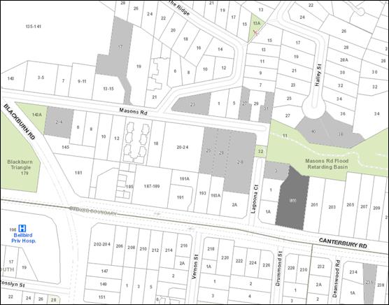
|
|
|
Subject site
|
|
23 Objector Properties
(11 outside of map)
|
é
North
|
BACKGROUND
History
· Planning
Permit WH/2008/294 was issued 12 June 2008 allowing the removal of nine trees
and the pruning of four trees.
· Planning
Permit WH/2015/346 proposing use and development of a childcare centre, tree
removal and alteration of access to a road in a Road Zone Category 1 was
refused under delegation, and VCAT upheld Council’s decision (refer to Sigmar
Pty Ltd v Whitehorse CC [2015] VCAT 226 (23 March 2016)).
· Planning
Permit Application WH/2016/1193 proposing a 122 place childcare centre with
associated vegetation removal and basement parking was also refused by Council
and not supported by VCAT (refer to Ausco Investment Group Pty Ltd v
Whitehorse CC [2018] VCAT 700 (11 May 2018)).
The Site and Surrounds
The subject site is located on the
north side of Canterbury Road in Blackburn, between Lagoona Court and Boulton
Road, east of Blackburn Road. The site currently contains a double storey
brick, detached dwelling along with a number of mature trees, particularly
along the western side of the property.
The site is irregular in shape with
a frontage of 36.58 metres to Canterbury Road, a maximum depth of 82.12 metres
(along the north boundary) and comprises an overall site area of 2,537m2.
The site has a very gentle slope down from south-east to north-west. A
2.44 metre wide drainage easement runs along the north (rear) boundary of the
site.
The arborist report, prepared by
Arbor Report Victoria, provides an assessment of 42 trees. Trees numbered
1, 2, 4, 5, 7, 8, 9, 10, 13, 14, 15, 16, 17, 18, 19, 20, 21, 22, 23, 27,
28, 29 and 32 are protected under the Significant Landscape Overlay Schedule
2. A total of 31 trees are located within the subject site, and
these trees have a mix of low and medium retention value and are a mix of Brush
Box, Yellow Gum, Yellow Box, Himalayan Cedar, Swamp Gum, Silver Stringybark,
Pittosporum and Golden Elm. Tables summarising the affected trees on the
subject site and adjacent lots are included under the Planning Controls heading
below.
Within the immediate context the
following is noted:
· The
site abuts three residential properties to its west. These properties
front Lagoona Court, and No. 1A Lagoona Court provides a setback of 6.5 metres
to Canterbury Road.
· To
the east, the adjacent lot at 201 Canterbury Road contains a single storey
dwelling, setback approximately 37 metres from the front boundary.
Planning Permit Application WH/2019/112 has been lodged proposing use and
development of land for the purpose of a medical centre, removal of vegetation
and alteration of access to a road in a Road Zone Category 1. This
application includes the removal of Trees 3 and 32. This application is
yet to be determined.
· Further
east, at 203 Canterbury Road, is a single storey dwelling on a lot of 1,845m2.
VCAT recently approved the development of this site for four dwellings
comprising two pairs of attached double storey dwellings (Planning Permit
WH/2017/789). The proposed dwelling density approved is one dwelling per
461m2.
· The
rear (north) of the site abuts the Mason Road Retarding Basin, which is under
Melbourne Water’s control (and contained within the Public Use Zone,
Schedule 1). This reserve includes a walking track and presents a
park-like quality with a bushland feel. A cyclone wire fence is located
along the common boundary with the subject site.
· To
the south of the subject site is Canterbury Road, which is a significant
six-lane arterial road with east and west bound lanes. Beyond this there
are residential lots that are also included within the Significant Landscape
Overlay Schedule 2.
The topography within the vicinity
of the subject site is undulating. Canterbury Road rises east towards Forest
Hill Chase Shopping Centre whilst the low point is adjacent to the subject
site. The road rises to the west beyond Lagoona Court. The width of
the road and topography produce linear views along the corridor of the canopy
trees within the road reservation and frontage setbacks of the dwellings.
A bus stop is located to the west
of Lagoona Court, on the north side of Canterbury Road. There is also a bus
stop on the south side of Canterbury Road, east of Deanswood Road. The
Forest Hill Chase Shopping Centre is located on Canterbury Road, approximately
265 metres to the east of the subject site.
Planning Controls
The proposal triggers the need for
a Planning Permit under the following clauses of the Whitehorse Planning
Scheme:
Neighbourhood Residential Zone
Schedule 1
Pursuant to Clause 32.09-6 a permit
is required to construct two or more dwellings on a lot. A development
must meet the requirements of Clause 55.
Pursuant to Clause 32.09-4 a development must meet a minimum
garden requirement of 35% (given the overall site area). The development
plans indicate an area of 1,144 square metres or 45.09%.
Significant Landscape Overlay
Schedule 2
Pursuant to Clause 42.03-2 a permit is required for the
removal or lopping of protected trees and/or for works within 4 metres of
protected trees. The proposed impacts to protected trees are summarised
in the table below:
|
Tree No.
|
Species
|
Common Name
|
Height
|
Condition
|
Trigger under SLO9
|
|
4
|
Eucalyptus melliodora
|
Yellow Box
|
11m
|
The three trunks appear to have sprouted from the stump of a tree
|
Removal
|
|
14
|
Eucalyptus ovata
|
Swamp Gum
|
9m
|
Tree has two trunks.
Located in adjacent lot
|
Buildings and
works within 4m
|
|
15
|
Eucalyptus ovata
|
Swamp Gum
|
21m
|
Decay and storm damage. Medium retention value
|
Buildings and
works within 4m
|
|
16
|
Eucalyptus ovata
|
Swamp Gum
|
15m
|
In decline
Located in adjacent lot
|
Buildings and
works within 4m
|
|
19
|
Eucalyptus ovata
|
Swamp Gum
|
19m
|
Poor condition with ivy growing up the trunk
Medium retention value
|
Buildings and
works within 4m
|
|
20
|
Eucalyptus ovata
|
Swamp Gum
|
10m
|
Significant lean and ivy growing up the trunk
Low retention value
|
Buildings and
works within 4m
|
|
21
|
Eucalyptus ovata
|
Swamp Gum
|
14m
|
Some branches previously removed.
Located in adjacent lot
|
Buildings and
works within 4m
|
|
22
|
Ulmus glabra
|
Golden Elm
|
14m
|
The base of the trunk is decayed and hollow.
|
Removal
|
|
23
|
Morus nigra
|
Mulberry
|
6m
|
Serious decay and borer infestation of the trunk
|
Removal
|
|
29
|
Acacia floribunda
|
Gossamer Wattle
|
-
|
This tree is located in the adjacent reserve and has fallen
over.
|
One branch overhanging the boundary to be lopped to the fenceline.
|
|
32
|
Corymbia citriodora
|
Lemon Scented Gum
|
28m
|
Storm damage to canopy
Located in adjacent lot
|
Buildings and
works within 4m
|
Schedule 2 to the Significant Landscape Overlay sets out a
number of ‘permit triggers’ for buildings and works, by which any
application would be considered under its merits and tested against the listed
objectives and decision guidelines. The following triggers are relevant
to the current application
|
Permit
trigger
|
Assessment
|
|
The building is no higher than two
storeys or 9 metres.
|
The dwellings are no higher than two storeys or 9 metres
No permit required
|
|
The building is set back at least 9
metres from the front boundary for a single storey building or 11 metres for
a two-storey building.
|
Dwelling 1 is two storey and setback 13 metres.
Dwelling 5 is two storey and setback 9 metres.
Permit trigger- Dwelling 5
|
|
The building (except for a garage) is set
back at least 1.2 metres from any other boundary for a building wall height
of no more than 3.6 metres or 1.5 metres plus half the building wall height
if the building wall height is more than 3.6 metres
|
Dwelling 3 has its garage wall adjacent to the east
boundary with the upper level setback 1.8 metres
The upper level to Dwelling 4 is setback 3.4 metres
Permit trigger- Dwellings 3 and 4
|
|
The building is less than 33 per cent of
the site area at ground level and 25 per cent of the site area at first floor
level, excluding hard surfaces and impervious areas.
|
The total building area is
747.7 square metres which equates to a site coverage of 29.47%.
The first floor building
site coverage is 20.46%.
No permit required
|
|
Hard surfaced and
impervious areas (including tennis courts and swimming pools, but excluding
buildings) are less than 17 per cent of the site area.
|
Paving hard surface area is
406.12 square metres which equates to 16% of the site area
No permit required
|
|
The total area of
all buildings and hard surfaces and impervious areas (including tennis courts
and swimming pools are less than 50 per cent of the site area.
|
The total building and
paving hard surface coverage is 45.47%
No permit required
|
Road Zone, Category 1
Pursuant to Clause 52.29 a permit is required to alter the
access arrangements (widen crossover and intensify usage) to a road in a Road
Zone Category 1.
PROPOSAL
When lodged, the application initially sought approval for
six double storey dwellings. In response to issues raised by Council
officers, the application was amended to five double-storey dwellings.
Subsequently to the Consultation Forum discussed below, updated plans were
submitted and advertised to objectors. The amendments made in the revised
plans are detailed in the Consultation Forum section below. These plans
are discussed in this report, and the amendments will be included in the
conditions, should a permit issue. The key features of the revised
proposal include:
· Widening
of the crossover westwards by approximately 2 metres.
· A
centrally located common property driveway with Dwellings 1 and 2 located on
the western side and Dwellings 3, 4 and 5 located on the eastern
side. All dwellings are detached and have separation distances
varying between 3 and 7.9 metres at the ground level, and upper level setbacks
of at least 5 metres.
· At
the site frontage, Dwelling 1 is setback 13.8 metres and Dwelling 2 is setback
9 metres from Canterbury Road.
· Dwelling
5 has its front entrance facing Canterbury Road with remaining dwellings
fronting the internal common property driveway.
· Each
dwelling provided a double-width garage, kitchen, meals and living area (with additional
living area for Dwelling 4) and guest bedroom at ground level and four
bedrooms, bathroom, and sitting area (except for Dwelling 4) at first floor
level.
· The
total floor areas and secluded private open space areas for the proposed
dwellings are as follows:
|
Dwelling
|
Floor Area (ground and
upper levels)
|
Area of private open
space
|
|
1
|
242.3m2
|
115.8m2 (western
setback), plus approximately 200m2 within the front setback
|
|
2
|
258.6 m2
|
138.9m2 (western
setback)
|
|
3
|
285.4 m2
|
268.1m2 (rear
setback)
|
|
4
|
275.9 m2
|
75.3m2 (eastern
setback)
|
|
5
|
231.6 m2
|
65.1m2 (eastern
setback) plus approximately 150m2 within the front setback
|
· The
setbacks to the west side boundary vary between 4.8 and 8.57 metres. The
setbacks to the east side boundary vary between 1.2 and 7.1 metres, except for
the Dwelling 3 garage which is proposed to abut the boundary. The setback
to the angled rear (north) boundary vary between 5.4 metres and 16.5 metres.
· The
garage to Dwelling 3 is attached to the east boundary.
· External
materials include face brickwork at ground level, rendered finish to
lightweight cladding at first floor level and tile cladding to hipped roof
forms.
· The
maximum height is 7.91 metres (Dwelling 5).
· The
building site coverage is 29.47%.
· The
proposed dwelling density is 1:507.5m2.
· No
front fencing is proposed.
· The
trees to be removed are:
o Protected Trees 4, 22
and 23.
o Trees not protected by
the SLO2: Trees 6 (dead), 11, 12, 24, 30, 31, 33, 34 (dead), 35, 36, 37, 38,
39, 40 and 42.
· The
trees on the subject site to be retained are:
o Protected Trees 1, 2, 5,
8, 9, 10, 13, 15, 18, 19, 20, 27 and 28.
o Trees not protected by
the SLO2: Trees 3 and 41.
CONSULTATION
Public Notice
The application was advertised by
mail to the adjacent and nearby property owners and occupiers and by erecting a
notice on the site frontage. The application received 23 objections,
raising the following concerns:
· Neighbourhood
Character:
o Building bulk and form
o Not in keeping with SLO2
o Excessive building
coverage- exceeding the as-of-right requirement under the SLO2 and the previous
childcare centre proposal
o Insufficient boundary
setbacks
o Inadequate setbacks to
Masons Reserve, and chain mesh fencing should be used instead of palings at
this boundary
o Not compliant with the
Neighbourhood Residential Zone and the Bush Environment Precinct requirements
referenced in Clause 22.03
· Landscaping:
o Tree removal and lopping
- much has already occurred
o Insufficient landscape
areas or tree planting
o The easement along the
rear boundary will limit tree planting opportunities at this interface.
o Trees 19 and 20 not
shown on plans
o Only one tree with a
mature height of 12 metres is proposed. Many replacement trees are dwarf
varieties or exotics, and do not reflect the indigenous landscape character of
the area or Masons Road reserve to the rear.
o The proposed landscaping
does not reflect the SLO2 landscape character and will not support local
wildlife.
Consultation Forum
A Consultation Forum was held on 11
December, 2019. Fifteen objectors, three representatives for the applicant and
the Planning Officer attended the meeting, which was chaired by Councillor
Massoud. The Forum followed an issues-based discussion, expanding on the
objections received. Additional concerns raised by objectors included:
· There
is no diversity of dwellings proposed, and the dwellings are unsuitable for an
ageing population.
· The
proposal would set an undesirable precedent.
· VCAT
recently refused a Planning Permit Application (WH/2018/1396) for five
semi-detached and detached double storey dwellings above a communal basement at
124-126 Blackburn Road, within the SLO2 area.
· Provision
of a continuous line of buildings along the east boundary is inconsistent with
the preferred Bush Environment character.
· The
proposed dwellings have a greater site coverage than the previously refused
childcare centres on this site.
· Some
of the trees proposed to be removed were replacement trees required by previous
planning permits
· Concern
that the development statistics (such as number of bedrooms/building
coverage/permeability) were incorrectly or inconsistently reported within the
application documentation.
In favour of the design response, a
representative of the Blackburn Village Residents Group advised that the west
boundary was historically a creek and a number of large remnant indigenous
trees were located along this interface, and the provision of reduced setbacks
to the east boundary was required to provide generous setbacks to these remnant
trees to the west.
All parties agreed to the retention
of the existing mesh fencing along the northern boundary interface with the
Masons Road Retarding Basin.
The applicant agreed that the
advertised landscape plan was not consistent with the preferred SLO2 landscape
character and advised that they had met with representatives of the Blackburn
Village Residents Group and were finalising an improved landscape plan that
included tree and shrub species more appropriate to the area, and retention of
more of the existing trees. It was agreed that the updated landscape plan
would be submitted and circulated to objectors for review, and this has
occurred. The key changes in the amended plans are:
· Retention
of the existing cyclone wire fence on the rear boundary with the Masons Road
Reserve.
· Correction
of an error on plans to show retention of Trees 19 and 20.
· Remove
references to the previous six dwelling proposal.
· Updated
landscape plan incorporating Forum comments and updating canopy tree species
and understorey vegetation.
Conditions will give effect to
these alterations.
Fifteen objections have been
received to the amended plans (twelve from original submitters), which
continued to raise the original objector concerns listed above, and added the
following additional issues:
· The
proposed dwelling density does not comply with the preferred 1:650m2
for the SLO2 area.
· No
outdoor living areas (decks/paving) have been shown for the dwellings.
Referrals
External
Department of Transport
The application was referred to the
Department of Transport. The application is supported subject to
conditions and notes being placed on the permit.
Melbourne Water
The application was referred to
Melbourne Water, who advised that the subject site is not subject to flooding
from a Melbourne Water drain or waterway from a storm event which has a 1%
chance of occurrence in any given year.
The Authority does not object to
the proposal subject to a condition being placed on the permit.
Internal
Engineering and Environmental
Services Department
· Transport
Engineer
The application has been reviewed
by Council’s Transport Engineer, who advised that the swept path diagrams
indicated a number of turning manoeuvres in a reverse direction which is not
considered to constitute ease of access. To address this issue, it is
recommended that a condition require the landscape area outside the entry to
Dwelling 1 be reduced by 1 metre to improve access.
· Waste
Engineer
The application has been reviewed
by Council’s Waste Management Team. The submitted Waste Management
Plan is approved subject to conditions and notes being placed on the permit.
· Assets
Engineer
The application has been reviewed
by Council’s Asset Engineer. The application is supported subject
to conditions and notes being placed on the permit.
Planning Arborist
The application has been reviewed
by Council’s arborist. The application is supported subject to tree
protection conditions being placed on the permit.
Parkswide Arborist
Council’s Parkswide Arborist
has required Tree 29, which is overhanging the subject site, to be pruned by
Parkswide staff, and tree protection measures to be observed.
Recreation and Open Space
If the rear boundary fence shared
with the Masons Road Retarding Basin is replaced, the existing postholes should
be utilised for the new fence, or tree protection measures must be observed for
any new postholes.
ESD Advisor
The application is supported,
subject to conditions being placed on the permit.
DISCUSSION
Consistency with State and Local
Planning Policies
The strategic intent of the
Planning Policy Framework is to encourage infill development that responds
appropriately to the context and character of the neighbourhood. Clause
11.01-1S Settlement of the Scheme directs infill development to areas that are
well serviced, close to activity centres and along existing transport routes.
The site is one of the larger lots
within the neighbourhood context and enjoys physical and strategic attributes
which make it suitable for some form of small scale infill development.
The site is located approximately 265 metres west of Forest Hill Chase Shopping
Centre and therefore supports the concept of the ‘20 minute
neighbourhood’ sought in Clause 15.01-4R Healthy Neighbourhoods-
Metropolitan Melbourne and Clause 16.01-2R Housing Opportunity Areas -
Metropolitan Melbourne. The site is also located on a main road and
Clause 18.02-2R Principal Public Transport Network seeks to increase the
diversity and density of development along the Principal Public Transport
Network (PPTN) corridors.
Clause 21.06 Housing is informed by Council’s
Housing Strategy, 2014 which places the subject site within a
‘limited change’ area. Limited change areas enable specific
characteristics of the neighbourhood, environment or landscape to be protected
through greater control over new housing development. These areas represent the
lowest degree of intended residential growth in Whitehorse.
Clause 22.03 Residential
Development Policy applies and the relevant objectives of Clause 22.03 are as
follows:
· To
ensure that residential development within the City of Whitehorse is consistent
with the built form envisaged for the relevant category of housing change.
· To
ensure development contributes to the preferred neighbourhood character where
specified.
· To
ensure that new development minimises the loss of trees and vegetation.
· To
ensure that new development provides adequate vegetation and gardens consistent
with the preferred neighbourhood character.
Clause 22.03 references the Neighbourhood
Character Study 2014 which provides specific Bush Environment Guidelines.
Clause 22.04 (Tree Conservation)
encourages existing and new trees to have sufficient space and
separation from buildings and impervious surfaces to successfully obtain their
optimum height and avoid any damage to property in the future.
In the VCAT decision
on the four dwelling proposal at 203 Canterbury Road, the Tribunal reviewed
Whitehorse’s Policies and summarised them as follows:
The Planning Scheme seeks to
ensure that development acknowledges and responds to this significance in an
appropriate manner. In broad terms, the dominance of vegetation is to be
maintained and enhanced, with development having a more subservient role in its
appearance. Existing tall trees are to be retained and protected, and further
tree planting introduced to contribute to the area’s canopy. A bush-like
setting is sought. (at paragraph 25)
In relation to the proposal for No.
203 Canterbury Road to the east of the subject site, the Tribunal found that
development was acceptable as:
the zone, policies and SLO2 do
not prevent change in this area but seek to moderate the extent of development
to respond to the special landscape significance of the Blackburn Area. (at
paragraph 29)
The proposed development, subject
to minor variations, is consistent with the objectives and intent of
Council’s Residential Development Policy for developments within Limited Change and the Bush Environment Precinct areas.
Design and Built Form
The subject site is located in a
Bush Environment Precinct. Clause 22.03 Residential Development encourages the
following preferred character for this precinct:
Streetscapes dominated by
vegetation with subservient buildings frequently hidden from view behind
vegetation and tall trees. The buildings will nestle into the topography of the
landscape and be surrounded by bush-like native and indigenous gardens,
including large indigenous trees in the private and public domains.
Buildings and hard surfaces will
occupy a very low proportion of the site. They will be sited to reflect the
prevailing front, rear and side setbacks. The larger rear setbacks will
accommodate substantial vegetation including large canopy trees. The bushy
environs are complemented by street trees and a lack of front fencing.
Properties abutting and close to creeks and lake environs will contain more
indigenous trees and shrubs that act in part as wildlife corridors.
The subject site is also included
within the Significant Landscape Overlay, Schedule 2 (Blackburn Area 2).
The area is recognised as having special significance attributed to the quality
of the environment, which includes vegetation notable for its height, density,
maturity and high proportion of Australian native trees. This in turn
contributes to the significance of the area as a valuable bird and wildlife
habitat. The Schedule provides a number of landscape objectives to be
achieved, which can be summarised as retaining the dominance of vegetation
cover in keeping with the bush character environment and encouraging
development that retains an inconspicuous profile. The Schedule also
includes a number of ‘decision guidelines’ which test a
development’s responsiveness to a preferred neighbourhood and landscape
character.
It is considered that the proposal
balances the urban consolidation outcomes of the Planning Policy Framework with
the preferred landscape outcomes in the objectives and decision guidelines of
the Neighbourhood Residential Zone Schedule 1 (NRZ1), the Significant Landscape
Overlay Schedule 2 (SLO2), Clause 22.03 Residential Development and Clause
22.04 Tree Conversation.
Clause 21.05 Environment recommends
that lot sizes in the SLO2 are generally in accordance with the prevailing
minimum lot size of 650m2, in response, the proposal will produce a
dwelling density of one dwelling per 507m2. Despite the reduced
dwelling density, as discussed below, the proposed development is able to
achieve a high level of compliance with both the as-of-right requirements of
the SLO2 and with Schedule 1 to the Neighbourhood Residential Zone.
In proximity to the subject site,
the VCAT decision approving the development of two pairs of attached double
storey dwellings (WH/2017/789) at 203 Canterbury Road, allowed a dwelling
density of one dwelling per 461m2. In its decision, the
Tribunal considered the key issues of neighbourhood character, the landscape
objectives of the SLO2 and amenity impacts to surrounding properties. The
Tribunal found that:
o The built form of the
semi-detached dwellings was appropriate within the existing neighbourhood
character.
o Sufficient landscaping
was able to be retained/planted around the dwellings to achieve the preferred
landscape character.
o Minimum rear setback of
5.5 metres was allowed to the Masons Road Retarding Basin.
Overall, the proposed development
provides five detached dwellings and will be spacious and well-landscaped to
maintain the Bush Environment Character of the area.
By contrast, the proposed five
dwellings over a common basement at 124-126 Blackburn Road WH/2018/1396 that
was recently refused at VCAT proposed a dwelling density of 1:661m2,
but although the dwelling density was compliant, the extent of basement
excavation and the scale of the dwellings and limited setbacks resulted in an
unacceptable outcome. This demonstrates the value of a more holistic
approach to the assessment of an application, as is undertaken in this report,
and indicates that measuring compliance or non-compliance with specific policy
directions cannot, in isolation, be considered an appropriate measure for
planning outcomes.
Canterbury Road differs in its
character compared with the surrounding local residential streets, such as
Lagoona Court, which has no footpaths and where there is a very strong presence
of tall native and indigenous canopy trees in the public and private
realms. In contrast, a number of residential properties near to the
subject land fronting Canterbury Road, have high front fencing and some lots to
the east are less vegetated than the subject land and properties to its
west. There is also medium density housing approved nearby. These
features demonstrate capacity for a more robust form of housing within the
subject site, and equally, can still reflect the overarching landscape
qualities expected within an SLO2 area.
The Precinct Guidelines encourage
the provision of a single vehicle crossover as a means of minimising car
accommodation visible to the streetscape. The development provides
for a centrally located crossover and meandering driveway with generous
landscape buffers. This avoids any visual impact of car accommodation when
viewed from the streetscape and provides opportunity for an open front garden
setting, and for the provision of landscaping through the centre of the subject
site.
The Precinct Guidelines identify
front setbacks within the Precinct ‘as generally 6 to 8 metres with
new and infill developments usually displaying reduced front setbacks’.
The proposed setback to Canterbury Road for Dwelling 1 is 13.8 metres and the
setback for Dwelling 5 is 9 metres. These setbacks are generous, allow
for the retention of Trees 1, 2, 5, 8, 9 and 10 as well as the planting of two
additional proposed trees (one Acacia implexa and one Eucalyptus
radiata) within the site frontage. The retained and proposed trees
will filter views of the built form from the streetscape.
No front fence is proposed, which
will achieve an open site frontage and allow views of the trees and landscaping
within the front setback, in keeping with the Bush Environment Precinct
Character set out in Clause 22.03. The ground level of the subject site
is slightly lower than the Canterbury Road footpath level, and an existing
retaining wall at the site frontage is proposed to be retained. Existing
low retaining walls supporting the existing vehicle accessway are proposed for
removal, but replacement retaining walls are not indicated on the plans.
It is anticipated that these will be required to allow the accessway to
transition from the Canterbury Road level down into the subject site, and a
condition will require them to be shown.
The side and rear setbacks
throughout the lot are mostly generous and respond to the existing trees.
For example, the living area to Dwelling 1 is setback 7.5 metres from the west
boundary to allow for the retention of Tree 13; Dwelling 2 is setback between
7.5 and 8.5 metres from the west boundary to allow for the retention of Trees
15, 19 and 20 and Dwellings 2 and 3 are setback between 5.4 and 16.5 metres
from the north boundary to allow for the retention of Trees 21, 25, 27, 28 and
29. As discussed in the Consultation Forum, the trees along the west
boundary are the most significant remnant vegetation located on the lot, and
the provision of generous setbacks from these trees to maintain their future
health is consistent with the objectives of the SLO2.
Where there are fewer design
constraints along the east boundary, the development has reduced side
setbacks. This includes placement of the garage to Dwelling 3 adjacent to
the boundary, with Dwellings 3 and 4 otherwise setback a minimum of 1.2
metres. These reduced setbacks are adjacent to garages and carports
located within the adjoining lot to the east and do not impact on any
vegetation. It is noted that Dwelling 1 at the Canterbury Road frontage
is setback 7.1 metres from the east boundary, which will allow for a sense of
spaciousness at the site frontage.
The predominantly wide boundary
setbacks are complemented through ground level separation between
dwellings. This includes a minimum separation of 7.9 metres between
Dwellings 1 and 2 and a minimum of 3 metres between all other dwellings.
This separation allows for planting opportunities and maintains and reinforces
the rhythm of spacing between and around buildings.
The upper levels also enjoy generous setbacks to front, side
and rear boundaries. For the most part, the upper levels are recessed
from the ground floor below and with varying materials and hipped roof forms,
to assist with reducing the perception of visual bulk. However the upper
levels are large and could benefit from design variations to reduce their
prominence within the landscape. The suggested changes include:
· Remove
bedroom 4 to Dwelling 4. This will allow meaningful views through the
site from the east (which are currently ‘blocked’ by bedroom 4).
· The
Dwelling 3 ensuite to the master bedroom reduced so that it aligned with the
wall of the walk-in-robe. Again, this will improve viewlines at this
interface.
· The
removal of bedroom 4 of Dwelling 2. This will significantly reduce the
mass of built form of this upper level and remove the potential for overlooking
from its west-facing window.
The development proposes a site
coverage of 29.47% with the total first floor building area equating to
20.46%. This meets Standard B8, as varied by the Schedule to the Zone
(which encourages a ground level maximum site coverage of 40%) and is below the
‘permit trigger’ requirements listed within the SLO2. This
demonstrates the ability to meet a preferred built form character and respond
to the features of the site (including capacity for tree retention).
The heights of the dwellings are
below the mandatory limit identified within the NRZ1 and the permit trigger
requirements under the SLO2. This contributes to the dwellings
maintaining an inconspicuous profile within the setting.
Interface with Mason Road Flood
Basin
The north boundary of the site
abuts the Mason Road Flood Basin. This is a sensitive interface and the
preferred character statement for the Bush Environment states, ‘properties
abutting and close to creeks and lake environs will contain more indigenous
trees and shrubs that act in part as wildlife corridors’.
Objectors to the proposal identified concerns with inadequate setbacks to
Masons Reserve. The proposed retention of the existing cyclone wire
fencing also addresses objectors’ concerns.
The ground floor walls of Dwellings
2 and 3 are setback between 5.4 and 16.5 metres and the dwellings vary in
height between 7 and 7.1 metres. Whilst the dwellings will be larger and
closer than most of the other nearby dwellings that abut the flood basin, the
proposal provides acceptable responses as follows:
· Trees
25, 26, 27, 28 and 29 are located along the park interface (both within the
park and the subject site). These trees will provide a significant visual
buffer to proposed Dwellings 2 and 3.
· Although
the presence of a 2.4 metre wide easement along the rear boundary limits the
areas available for new tree planting, the landscape plan provides for a
further two Eucalyptus polyanthemos trees within the rear setback to
Dwelling 2.
· As
referenced above, it is recommended that the upper level bedroom 4 of Dwelling
2 be removed, reducing the visual bulk of the development when viewed from the
reserve.
Tree Removal and Landscaping
A landscape character objective of
the SLO2 is to encourage the retention of vegetation to maintain a bush
character environment. The application seeks the removal of 18 trees
across the site to accommodate the development, of which only Trees 4, 22 and
23 are protected under the SLO2. The remaining trees are either dead
(Trees 6 and 34) or are not large enough to warrant protection. The
application has been reviewed by Council’s Planning Arborist, who has
advised that given the species of vegetation, age, health and growth
characteristics, the loss of the proposed trees is not of concern.
The decision guidelines require consideration of a
development’s ‘potential to achieve an average density of one
tree reaching a height of over 15 metres to each 150 square metres of site
area’. Given the site area, this equates to 17 trees. The
proposal seeks to retain the following trees on the subject site:
|
Tree
No
|
Species
|
Height
|
Retention
value
|
|
1
|
Lophostemon confertus – Brush Box
|
7m
|
Medium
|
|
2
|
Eucalyptus leucoxylon – Yellow Gum
|
8m
|
Medium
|
|
3
|
Pittosporum undulatum - Sweet Pittosporum
|
6m
|
High
|
|
5
|
Syzygium paniculatum – Magenta Cherry
|
9m
|
Medium
|
|
8
|
Cedrus deodara – Himalayan Cedar
|
16m
|
High
|
|
9
|
Eucalyptus ovata – Swamp Gum
|
20m
|
Low
|
|
10
|
Grevillea robusta – Silky Oak
|
21m
|
Medium
|
|
13
|
Eucalyptus cephalocarpa – Silver Stringybark
|
10m
|
Medium
|
|
15
|
Eucalyptus ovata – Swamp Gum
|
21m
|
Medium
|
|
18
|
Pittosporum undulatum - Sweet Pittosporum
|
7m
|
Low
|
|
19
|
Eucalyptus ovata – Swamp Gum
|
19m
|
Medium
|
|
20
|
Eucalyptus ovata – Swamp Gum
|
10m
|
Low
|
|
27
|
Melaleuca linarifolia – Snow in summer
|
6m
|
Medium
|
|
28
|
Eucalyptus botryoides – Southern Mahogany
|
11m
|
Medium
|
|
41
|
Camellia japonica - Camellia
|
3m
|
Low
|
Ten of the retained trees on the subject site have the
potential to reach mature heights of 15 metres hence, to meet the density
requirement, a further seven trees are required. The landscape plan
proposes a further eight trees with a mix of species including, Acacia
implexa – Lightwood, Corymbia ficifolia – Dwarf
Flowering Gum, Eucalyptus polyanthemos – Red Box and Eucalyptus
radiata – Narrow-leaved Peppermint. These are predominantly
indigenous species and four of the proposed trees have mature heights of 15
metres, so three additional tall trees are required to achieve a compliant tall
tree density.
To achieve the required tree density, conditions will
require the replacement of two proposed Acacia implexa trees (south of
garage 1 and east of garage 5) with Eucalyptus radiata, capable of
reaching 15 metres mature height, and the planting of one additional Eucalyptus
radiata within the Dwelling 5 frontage, clear of the canopies of existing
trees. It is noted that the existing and proposed trees are well-setback from
the proposed dwellings, giving them the best opportunity to achieve mature
growth and maintain tree health into the future.
Of the trees to be retained within the subject site and
trees on adjoining lots, there is no encroachment greater than 10%, however it
is recommended that the shed serving Dwelling 3 is relocated eastwards clear of
the TPZ of Tree 21. It is anticipated that site cuts will be required for
the provision of utility service connections such as electricity and water, and
these have the potential to impact trees. In addition to the required
tree protection measures, a condition will require the locations of service
trenches to be shown on the plans to ensure that they do not unreasonably
impact on retained trees.
Amenity
Clause 55.04 sets out a number of
objectives and standards that seeks to ensure the amenity of adjoining
residential lots is not unreasonably impacted. When tested against the
standards, the development does not cause any loss of daylight to adjoining
windows, does not cause any overlooking and will not cause overshadowing to
adjoining areas of secluded private open space.
Standard B18 (Walls on boundaries)
as varied by the Schedule 1 to the Neighbourhood Residential Zone discourages
walls on boundaries, although the SLO2 allows for a garage wall abutting a
boundary. The garage to Dwelling 3 adjacent to the east boundary produces
acceptable outcomes as:
· There
are other examples of garage walls on side boundaries in the vicinity along
Canterbury Road.
· The
garage is setback a significant distance from Canterbury Road so as not to be
visible.
· The
height of the wall is 2.85 metres however will be partially cut into the
ground, therefore will sit 1.8 metres above natural ground level, keeping the
building form inconspicuous and only marginally higher than the 1.7 metre high
timber paling fence on the east boundary.
A condition of the permit will
require the east elevation of Dwelling 5 to correctly notate the upper level
windows to reflect the upper level floor plan (i.e. the east-facing master
bedroom window and sitting room windows are not shown). These windows
will not need to be screened as they will overlook the front setback area of
201 Canterbury Road.
In addition, further plan
corrections are required to correct the dimensioned west boundary setback of
the Dwelling 1 living room, and to remove a shed notation from beside the
Dwelling 3 laundry door.
Car Parking
Clause 52.06 specifies car-parking
rates that are applicable to this application at a rate of two spaces for a
dwelling with three or more bedrooms. Each dwelling is allocated a double
garage that satisfies the provision.
The site has a frontage to
Canterbury Road that is a designated road within a Road Zone Category 1.
The car parking arrangement has been designed to allow vehicles to enter and
exit the site in a forwards direction, and the Department of Transport has accepted
the proposed vehicle access, subject to standard conditions.
As the subject site is located
within the Principal Public Transport Network, no visitor car spaces is
required, however one visitor space has been provided, located between
Dwellings 4 and 5. This is a commendable outcome for this site, given its
location on Canterbury Road.
Objectors Concerns not Previously Addressed
· The
proposed dwellings have a greater site coverage than the previously refused
childcare centres on this site.
The more recent Tribunal decision
on Planning Permit Application WH/2016/1193 proposing a single storey childcare
centre above a basement car park was refused by the Tribunal primarily on built
form and landscape character grounds. In contrast to the previous childcare
centre, the proposed development achieves landscaped building breaks throughout
the centre of the subject site, and is a sufficiently different application
from the previous proposal that the ‘Repeat Appeal Principle’ does
not apply.
· Some
of the trees proposed to be removed were replacement trees required by previous
Planning Permits
Planning Permit WH/2008/294/A allowed
tree removal on the subject site, subject to a condition requiring the
replanting of eight additional trees, in order to achieve the preferred tall
tree density of 1:150m2. Whilst the removal of replacement
plantings is not ideal, these trees have not yet reached a height to make a
significant contribution to the landscape character. Further, the
retention of these trees would place an unreasonable burden on the subject site
which is otherwise suitable for some form of redevelopment. In
association with redevelopment of the subject site as proposed, the retention
of the most significant trees on the site has been prioritised. The
conditions of approval for this development also include replacement tree
planting generally in accordance with the preferred tall tree density.
· Concern
that the development statistics (such as number of bedrooms/building
coverage/permeability) were incorrectly or inconsistently reported within the
application documentation.
Car parking has been provided in
accordance with the proposed number of bedrooms per dwelling, and other
development statistics such as building coverage and permeability have been
checked. Some corrections to plans are required, as discussed above.
· No
outdoor living areas (decks/paving) have been shown for the dwellings.
The application has been assessed as
presented, and if additional works (paving or decking) are proposed in the
future, additional Planning Permit applications may be required if the proposed
works trigger consideration under the SLO2.
CONCLUSION
The proposal for construction of
development of the land for five double-storey dwellings, including associated
tree removal and buildings and works within 4 metres of protected trees, and
alteration of access to a Road Zone Category 1 is an acceptable response that
satisfies the relevant provisions contained within the Whitehorse Planning
Scheme, including the State and Local Planning Policies, the Neighbourhood
Residential Zone Schedule 1 and the objectives and decision guidelines of the
Significant Landscape Overlay Schedule 2.
A total of 23 objections were
received as a result of public notice and all of the issues raised have been
discussed as required.
It is considered that the
application should be approved.
Attachment
1 WH/2019/2 Plans

Ordinary Council Minutes 16
March 2020
Strategic Planning
9.1.3 Amendment
C219 to the Whitehorse Planning Scheme Municipal Wide Significant Landscape
Overlay Consideration of Planning Panel report
FILE
NUMBER: SF19/394
ATTACHMENT
SUMMARY
Amendment C219 to the Whitehorse Planning
Scheme implements the findings of the Municipal Wide Tree Study (Part 1 - 2016
and Part 2 - 2019) to retain and enhance tree canopy in the City of Whitehorse.
The Amendment seeks to apply Schedule 9 to the Significant Landscape Overlay
(Clause 42.03) on a permanent basis to all residential land that does not
already have a permanent SLO in place. In addition, the Amendment makes
consequential changes to local policy clauses in the Whitehorse Planning Scheme
to support the proposed tree controls.
Exhibition of the Amendment took place
from 18 July until 19 August 2019 and a total of 307 submissions were received
to the Amendment. An independent Panel hearing was held on 2, 4, 5 and 6
December 2019 to consider the submissions and the Amendment.
This report
informs Council about the Planning Panel recommendation, which is that
Amendment C219 should be adopted as exhibited, subject to amending Schedule 9
to the SLO to the Panel preferred version.
It is
recommended that Amendment C219 be adopted, in accordance with the Panel
report.
|
recommendation
That Council, being the Planning Authority, and
having considered the Panel Report for Amendment C219 under section 27 of the
Planning and Environment Act 1987 (‘the Act’):
1. Support the key findings and recommendations
given in the Panel Report at Attachment 1.
2. Adopt
Amendment C219 with the Panel preferred version of Schedule 9 to the
Significant Landscape Overlay, as per Appendix D of the Panel Report and at
Attachment 2.
3. Submit
the adopted Amendment to the Minister for Planning for approval under section
31 of the Act with the appropriate fee.
4. If
the Amendment is not approved by 30 April 2020, submit a request to the
Minister for Planning under section 20(4) of the Act to extend the existing
interim Schedule 9 to the Significant Landscape Overlay for a further 6
months (until 31 December 2020) or until the Minister for Planning determines
to approve or refuse the Amendment under section 35 of the Act.
5. Advise
all submitters to Amendment C219 of this resolution.
|
|
MOTION
Moved by Cr Davenport, Seconded by Cr Massoud
That Council, being the Planning Authority, and
having considered the Panel Report for Amendment C219 under section 27 of the
Planning and Environment Act 1987 (‘the Act’):
1. Support
the key findings and recommendations given in the Panel Report at Attachment
1.
2. Adopt
Amendment C219 with the Panel preferred version of Schedule 9 to the
Significant Landscape Overlay, as per Appendix D of the Panel Report and at
Attachment 2.
3. Submit
the adopted Amendment to the Minister for Planning for approval under section
31 of the Act with the appropriate fee.
4. If
the Amendment is not approved by 30 April 2020, submit a request to the
Minister for Planning under section 20(4) of the Act to extend the existing
interim Schedule 9 to the Significant Landscape Overlay for a further 6
months (until 31 December 2020) or until the Minister for Planning determines
to approve or refuse the Amendment under section 35 of the Act.
5. Introduce
free arborist services for tree removal applications under VicSmart, as per
Council Officer report, commencing on 1 July 2020 (if the planning scheme
amendment is approved by the Minister, or an extension granted)
6. Advise
all submitters to Amendment C219 of this resolution.
|
|
AMENDMENT
Moved by Cr Barker
That Council, being the Planning Authority, and
having considered the Panel Report for Amendment C219 under section 27 of the
Planning and Environment Act 1987 (‘the Act’):
1. Support
the key findings and recommendations given in the Panel Report at Attachment
1.
2. Adopt
Amendment C219 with the Panel preferred version of Schedule 9 to the
Significant Landscape Overlay, as per Appendix D of the Panel Report and at
Attachment 2.
3. Submit
the adopted Amendment to the Minister for Planning for approval under section
31 of the Act with the appropriate fee.
4. If
the Amendment is not approved by 30 April 2020, submit a request to the
Minister for Planning under section 20(4) of the Act to extend the existing
interim Schedule 9 to the Significant Landscape Overlay for a further 6
months (until 31 December 2020) or until the Minister for Planning determines
to approve or refuse the Amendment under section 35 of the Act.
5. Introduce
subsidised arborist services for tree removal applications under VicSmart, as
per Council Officer report, commencing on 1 July 2020 (if the planning scheme
amendment is approved by the Minister, or an extension granted)
6. Advise
all submitters to Amendment C219 of this resolution.
The Amendment
LAPSED for want of a Seconder
|
|
The Motion moved
by Cr Davenport, seconded by Cr Massoud was then put and CARRIED
|
background
Council commenced the Municipal
Wide Tree Study in December 2015 as a direct result of concerns that the
neighbourhood character of Whitehorse will be diminished if trees are removed
or lopped. This work recognised that current, as well as future trees,
contribute to the landscape and neighbourhood character of the municipality, as
well as providing fauna habitat, cooling of properties, supply of oxygen and
contribution to visual amenity. The Study ultimately recommended that Council
extend the Significant Landscape Overlay (SLO) across all residential land that
is not already covered by an SLO.
On 26 May 2017 Council submitted a
request to the Minister for Planning (the Minister) to approve Amendment C191
to the Whitehorse Planning Scheme (Planning Scheme) to apply the SLO on an
interim basis to all residential land that does not already have tree
protection controls in place under an existing permanent SLO. Council also
sought authorisation to prepare and exhibit Amendment C196 to apply the same
controls on a permanent basis.
On 28 December 2017 the Minister
approved Amendment C191, which came into effect on 8 February 2018 and
introduced Schedule 9 to the SLO (SLO9) on an interim basis until 31 December
2018. The interim SLO9 required a planning permit for removal, destruction or
lopping of trees with a height of 5 metres or more or a trunk circumference of
1 metre or more at 1 metre above the ground.
The Minister refused
Council’s request to prepare and exhibit Amendment C196, instead
directing Council to undertake further strategic work before submitting a new
request to apply the same controls on a permanent basis.
On 18 December 2018 the Minister
extended the lapse date for the interim SLO9 by 6 months until 30 June 2019
(Amendment C214). Council engaged planning consultants to assist in undertaking
the further strategic work, titled Municipal Wide Tree Study, Part 2:
Additional Analysis in Garden Suburban and Bush Suburban Character Precincts, March
2019. The further work was adopted by Council at its meeting on 18 March 2019.
On 3 April 2019 Council submitted a
new request to the Minister to prepare and exhibit Amendment C219 to
permanently apply SLO9. On 27 June 2019 Council received notice that the
Minister had authorised Council to prepare and exhibit Amendment C219. On 28
June 2019 the lapse date for the interim SLO was extended via Amendment C223 by
a further 1 year until 30 June 2020 to allow the completion of the amendment
process for the permanent controls.
Amendment C219 proposes additional
planning permit exemptions beyond those within the interim controls, being:
§ Trees located less than 3
metres from the [existing] wall of a dependent person’s unit or dwelling
§ Trees located less than 3
metres from an [existing] in-ground swimming pool
§ specified environmental weeds
§ Trees affecting public
utilities including powerlines, services within easements and the like
§ Street trees in line with
Council’s Street Tree Policy
§ Trees required to be removed,
destroyed or lopped in order to construct or carry out buildings or works
approved by a Building Permit issued prior to 8 February 2018
§ Trees that may require
separate approval to remove, destroy or lop as part of an existing permit
condition, a plan endorsed under a planning permit or an agreement under
section 173 of the Planning and Environment Act 1987
Exhibition of the Amendment took
place from 18 July until 19 August 2019. A total of 307 submissions were
received (303 submissions were received during the exhibition
period and four [4] late submissions were received). At the
meeting on 16 September 2019 Council resolved to request that the Minister for
Planning appoint an independent Planning Panel to consider the submissions
received to the Amendment. The Panel Hearing was held on 2, 4, 5 and 6 December
2019.
All submissions were referred to
the Planning Panel and 27 submitters spoke at the Panel Hearing, including
local residents, community groups and land owners. Council called expert
evidence in planning and arboriculture.
The Panel Report (refer Attachment
1) was received by Council on 23 January 2020 and was released to the public on
30 January 2020, in accordance with the Council policy of releasing Panel
reports within 7 days of receipt.
DISCUSSION
Summary of Panel Report
The Panel recommended that
Amendment C219 be adopted as exhibited, subject to amending SLO9 to the Panel
preferred version.
The Panel summarised their main
conclusions under the following hearings:
· Strategic
justification
· The
Municipal Wide Tree Study
· Individual
issues
· Form
and content of the Amendment
Strategic justification
The Panel noted that the
“Amendment is supported by a considerable body of work and
analysis” (p11 of Panel Report). The Panel commented that “the role
that…trees play…in defining the character of an area is well
established in Plan Melbourne, the Planning Policy Framework (PPF) and
local policy” (p11 of Panel Report).
The Panel noted that Council has
undertaken a range of studies to establish the justification for the Amendment.
The Panel concluded that the “Amendment is supported by, and implements,
the relevant sections of the PPF, and is consistent with the relevant
Ministerial Directions and Practice Notes” (p 11 of Panel Report).
The Municipal Wide Tree Study
The Panel concluded that the
Discussion Paper identified that “tree cover was an essential element”
to the character of the municipality, as well as the eastern region of
Melbourne. The Panel identified as a consistent theme that tree cover is
decreasing across the municipality, which is reinforced in Living Melbourne
(Living Melbourne: Our Metropolitan Urban Forest, 2019), and work
undertaken by RMIT (Interim Report: Urban Vegetation Cover Analysis Eastern
Region, 2018).
The Panel concluded that “the
work presented in the three documents that make up the Study is substantial and
comprehensive and an appropriate basis for the introduction of broader tree
protection in the municipality” (p 18 of Panel Report). The Panel
acknowledged that there may be pressure between protecting trees and increased
housing, however also that planning needs to balance competing interests such
as these and that the SLO9 does this in a reasonable way.
The Panel concluded that the Tree
Study is an appropriate basis for the permanent introduction of the proposed
controls and that SLO9 will not have an impact on housing growth. The Panel
also found that SLO9 is an appropriate tool for the protection of trees across
the municipality, including in the Bush Suburban and Garden Suburban character
areas.
Individual issues
Safety hazard and dead, dying
and dangerous trees
The issues examined by the Panel
were whether the introduction of SLO9 will cause safety concerns about trees in
residential areas, and whether the permit exemptions applying to dead, dying
and dangerous trees are appropriate.
Several submitters raised concerns
about the safety of large canopy trees in residential areas. Council submitted
that trees on private property are the responsibility of the landowner, and
that SLO9 will not change such responsibility. Council also submitted that SLO9
will not prevent the removal, destruction or lopping of dead, dying or
dangerous trees.
The Panel recognised the concerns
about safety and agreed with Council that landowners are responsible for
maintaining trees on their property. The Panel concluded that tree safety is
correctly considered by the Amendment, particularly by the permit exemptions
relating to dead, dying and dangerous trees.
The Panel concluded that an
additional decision guideline could be included which deals with the provision
of replacement trees where trees are removed or destroyed, which will support
the landscape character objective included in SLO9 relating to planting of
canopy trees. The Panel also recommended that Council’s arborist provide
pre-application assessment to provide initial advice on the health of the tree
to help determine whether or not a permit is required.
Imposition on private property
rights and cost burden
The issues examined by the Panel were whether the SLO9
imposes restrictions over private property rights and whether the Amendment imposes
burdensome costs for a planning permit to remove a tree.
Council’s substantive position put forward to the
Panel was that the SLO9 is the best control to protect and reinforce the
importance of canopy trees in contributing to the significant neighbourhood
character of Whitehorse. Furthermore “trees should be protected to ensure
that landscape values are not compromised by development” and
“there are benefits from applying this form of control [the SLO9] in
limiting unfettered removal of trees” (p 24 and 26 of Panel Report).
Several submitters believe that the Amendment is an
imposition on private property rights and does not allow individual choice in
removing single trees for aesthetic or amenity purposes. Some submitters also
consider the cost for a permit to remove a tree is burdensome.
The Panel acknowledged these concerns however concluded that
the imposition on private property rights is acceptable given the broader
community benefits that result from the protection and replacement of canopy trees
and their contribution to neighbourhood character.
The Panel also concluded that the cost of the permit process
is reasonable, and that it could be further mitigated for individual tree
removal applications. In this regard the Panel concluded that Council
should consider waiving the permit fee for VicSmart tree removal applications
and engage an arborist to provide the assessment on such applications.
Consistency with SLO1-8
The Panel examined whether the
controls in the SLO9 should be the same as those in SLO1-8.
Several submitters wanted SLO9 to
replicate the existing SLOs 1-8. Council submitted that the additional work
undertaken concluded that the height and girth requirements, amongst other
differences, was appropriate for SLO9.
The Panel identified that SLO9
generally applies across the GRZ, NRZ and RGZ areas (Garden Suburban and Bush
Suburban Character areas) where some redevelopment is expected to occur,
whereas SLOs1-8 covers mostly NRZ and Bush Environment Character areas. The
Panel concluded that it is appropriate for the controls of SLO9 to differ from
those in the existing SLOs 1-8.
Intent of the controls
The Panel considered whether the
Amendment would have a detrimental effect on canopy tree protection and
enhancement.
Several submitters were concerned
that the Amendment will not achieve its intention and that it was not clear
enough in supporting replacement planting. Some submitters stated that the
Amendment fails to address the issues around higher density development which
they believe is the significant cause of tree loss. Submitters also believe
that the Amendment will result in residents removing trees before they reach 5
metres in height.
Council’s arboricultural
expert stated that it was unlikely that the new controls would result in a
reduction in new trees being planted. Council’s expert also submitted
that it was unlikely that a landowner would cut down a tree before it reaches 5
metres in height given the effort and costs required to remove trees of this
size.
The Panel found that many
submitters believe SLO9 does not go far enough, while other submitters believe
it goes too far. The Panel states that there are higher level policies that
address housing density and that these should be addressed elsewhere in the
planning scheme. Council already has policies to guide housing growth and
development across the municipality. The Panel accepted the evidence that the
controls will not discourage landowners from planting trees. The Panel
concluded that SLO9 provides an acceptable level of control over tree loss and
from ‘moonscaping’ practices.
Application of SLO9 to public
land
The Panel considered whether SLO9
should be applied to private and public land.
One submitter questioned why SLO9
does not also cover public land, including road reserves and public parks.
Another queried the need for different mechanisms for tree protection between
private and public land.
Council submitted that the Whitehorse
Urban Forest Strategy provides guidance on tree management on public land
that is owned and/or managed by Council. The Strategy contains a Tree
Management Plan that also provides guidance for trees in parks and reserves.
The Panel concluded that the
exemptions relating to public land are acceptable and that it is not necessary
to expand SLO9 over public land as the Whitehorse Urban Forest Strategy
provides guidance to manage trees on public land.
Other issues
One submitter queried why his
property was covered by the VPO3 and SLO9, and the need to have two similar
controls on his land. The Panel acknowledged that they are similar controls
however they also concluded that the controls have different objectives and it
is therefore acceptable for a property to be covered by both.
Other submitters wanted additional
trees added to the list of environmental weeds which would not require a
planning permit to be removed. Conversely, another submitter felt a larger list
of environmental weeds would diminish the existing canopy cover as many mature
canopy trees are also environmental weeds.
The Panel agreed that an extensive
list of exempt weed species would have an adverse impact on canopy tree cover
across the municipality. The panel concluded that the list of environmental
weeds included in SLO9 is appropriate.
Form and content of the
Amendment
The Panel concluded that the
changes proposed to the Municipal Strategic Statement and existing local
policies at Clause 21.05 (Environment), Clause 21.06 (Housing), Clause 22.03
(Residential Development) and Clause 22.04 (Tree Conservation) of the Planning
Scheme are reasonable and support the introduction of SLO9. The Panel noted
that Council resolved at its meeting on 16 September 2019 to make changes to
SLO9 as a result of considering submissions. These changes are supported by the
Panel as being logical and beneficial and are included in Attachment 2.
The Panel questioned whether the
scope of the landscape objectives in SLO9 at sub section 2 were broad enough,
and felt that there should be additional objectives that relate to the
protection of landscape character. The Panel suggested the following additional
objectives:
To retain and enhance canopy
tree cover of the Garden and Bush Suburban Neighbourhood Character Areas
To ensure that development is
compatible with the landscape character of the area.
The exhibited SLO9 included an
exemption relating to trees:
A permit is required to remove,
destroy or lop a tree.
This does not apply to:
· A
tree less than 5 metres in height and having a single trunk circumference of
less than 1.0 metre at a height of 1.0 metre above ground level; or…
The Panel questioned whether any
consideration has been given to redrafting to improve clarity of the exemption.
During the Panel hearing, Council drew the Panel’s attention to a VCAT
decision (Ausgood Development Pty Ltd v Whitehorse CC [2018] VCAT 690)
where the interpretation of the permit exemption was considered. The VCAT
decision concluded that “a tree having either a height of 5 metres or
more or a circumference of more than 1.0m requires a permit under SLO9”
(p 42 of the decision).
Council advised the Panel that it
was satisfied with the proposed wording on the permit exemption and relies on
the VCAT decision as to how the exemption should be interpreted.
In considering the VCAT decision
and other evidence, the Panel believed that the wording of the exemption could
be amended to improve its clarity in line with the VCAT decision and
Council’s intent with what the exemption seeks. The Panel has provided
their preferred wording as follows:
A permit is required to remove,
destroy or lop a tree.
This does not apply to:
· A
tree that has both:
o A height of less than
5 metres; and
o A single trunk
circumference of less than 1.0 metre at a height of 1.0 metre above ground
level.
Response to Panel’s
report
Officers welcome the overall
recommendation of the Panel to adopt SLO9 as exhibited with minor changes. In
particular, officers support the Panel’s conclusions about the policy
basis at State and Local level for increasing tree canopy cover across metropolitan
Melbourne.
The Panel has suggested several minor changes to SLO9,
including the addition of new landscape character objectives and a new decision
guideline. Officers are satisfied with these minor changes as they reinforce
that the retention and enhancement of tree cover is important to the
municipality and contributes to the neighbourhood character of the City of
Whitehorse.
The Panel has also concluded that
the exemption provisions around tree height and width should be redrafted to
make them clearer. Officers have sought legal advice on the recommended changes
and are advised that the drafting recommended by the Panel reflects the VCAT
decision referenced above. Officers are satisfied with this suggestion and
believe that the change provides further clarity for those using the controls.
Beyond the above changes to the
planning provisions, the Panel has also suggested that Council:
· Should
consider the provision of pre-application advice from a qualified arborist
about the health of the tree (page 24 of Panel Report)
· Should
consider waiving the permit fee for VicSmart tree removal applications and
engaging an arborist to provide an assessment and report on these applications
(page 27 of Panel Report).
It is noted that there is further guidance under the
Panel’s discussion for both of these issues, which are each discussed
below.
Pre-application advice
The Planning Scheme, as it currently exists, contains
multiple overlay controls that require permission for the removal of trees and
vegetation that meet specific criteria. These same controls also provide
circumstances where removal of trees and/or vegetation is exempt from the need
for a planning permit. One of the more commonly used exemptions is where a
planning permit is not required to remove a tree “which is dead or
dying or has become dangerous to the satisfaction of the responsible authority”.
The Panel has suggested that Council consider the provision
of a service that offers qualified arboricultural advice on the health of a
tree on private property. Council’s Statutory Planning Unit currently
offers this service, where a landowner can contact Council and seek approval
for a tree on their land to be assessed as dead, dying or dangerous. All such
requests are given to Council’s Planning Enforcement officers to make an
assessment of the tree on-site. If the tree can clearly be identified as dead,
dying or dangerous, a Planning Enforcement officer will provide that advice to
the land owner and a permit will not be required. If it is not clear, an assessment
of the tree will be undertaken by one of Council’s consulting arborists.
There is no fee required for an assessment to be undertaken by Council’s
Planning Enforcement officer, nor when an assessment is undertaken by one of
Council’s consulting arborists.
If the land owner requires this advice be provided in
writing, as with all other requests for planning advice, a fee of $190 is
required for written confirmation. The exception to this is if the tree in
question poses an immediate danger, in which case advice is immediately
provided in writing to enable the tree to be removed.
In the event that a tree is assessed to not meet the
exemption criteria; that is, it is not assessed as dead, dying or dangerous,
land owners will be advised that a planning permit is required should they wish
to seek removal of the tree. This would usually be through the VicSmart
application process. If a land owner seeks this advice in writing, pays the
requisite fee, and subsequently lodges a VicSmart application for the tree to
be removed, the fees for the provision of the written planning advice are
transferred to cover the VicSmart application fee, which are comparable.
Council officers believe that this process is operating satisfactorily and will
continue to be offered as it stands.
Waiver of fee and subsidisation of arborist
A review of other Councils with similar planning controls,
shows that for applications for a small number of trees, Councils are often
providing the arborist assessment at a subsidised rate. Officers have also
reviewed the Panel’s suggestions to provide the arborist assessment and
waive the VicSmart fee. Given Council has already approved the salary of an
arborist for these controls, it is considered that Council could subsidise the
entire cost of the arborist assessment for VicSmart applications. It is suggested
that this should be capped at set number per year due to the tendency for some
applicants to lodge numerous VicSmart applications at one time. Officers
suggest capping the subsidy to 3 applications per year. This would result in a
saving of $300-$500 (per tree) for the applicant.
VicSmart fees for tree removal are a statutory fee of
$199.90. Council received 581 VicSmart applications in 2018-19 of which a
significant majority were for tree removal. To waive this fee would result in
lost income of at least $100,000 per year. This is just under the cost of
employing an arborist, but does not cover the entire cost of assessing these
applications. When fees under the Planning and Environment Act 1987
were reviewed in 2016, it was determined that the cost of assessing VicSmart
applications should be partially borne by Council. The VicSmart fee of $199.90
was determined on this basis. As such, Council considers that the waiver of the
VicSmart fee is not acceptable. Waiver of the fee can, however, be considered
on an individual basis.
Allowing the removal of more than one tree per VicSmart
application has been identified by the Statutory Planning Unit as a provision
that could be reviewed (due to the lesser administrative burden of assessing a
small number of trees). This could be further investigated as a local variation
to the VicSmart control which allows Councils to specify types of applications
that can be assessed through the VicSmart application process. In undertaking
this review, Council could also consider works within 4 metres of a protected
tree through the VicSmart process.
Reviewing the VicSmart controls will be presented to Council
at a future meeting.
CONSULTATION
Exhibition of the Amendment
occurred in the form prescribed by the Planning and Environment Act 1987.
Exhibition took place from Thursday 18 July until Monday 19 August 2019.
Exhibition involved the direct notification of all affected owners and
occupiers of properties in the municipality affected by the proposed Amendment,
totalling 81,947 letters. The notification of properties included a cover
letter, information flyer and the statutory Notice of Preparation of Amendment.
Prescribed Ministers, local Members of Parliament, public authorities,
arborists and community groups were also notified.
The Notice of Preparation of
Amendment was published in the Whitehorse Leader on 15 July 2019 and in the
Victoria Government Gazette on 18 July 2019. A notice also appeared in
subsequent weeks of the Whitehorse Leader until the end of the exhibition
period and an article was published in the August edition of the Whitehorse
News. Information was also available on the Council webpage, Council’s
telephone on hold message and the Council OurSay landing page. Multi lingual
information was available on the Council webpage and in the information flyer
and letter to all affected owners and occupiers.
Council officers presented the
Amendment to Elgar Contact’s July 2019 meeting at their request. For the
duration of the exhibition period copies of the Amendment documents were
available for viewing at the following locations:
· Planning
Counter at the Whitehorse Civic Centre
· Council’s
Customer Service Centres at Box Hill Town Hall and Forest Hill Chase Shopping
Centre
· Libraries
at Nunawading, Box Hill, Blackburn and Vermont South
· Sportlink,
Vermont South
· Aqualink
Nunawading and Aqualink Box Hill
· Burwood
Neighbourhood House
· Bennettswood
Neighbourhood House
· Kerrimuir
Neighbourhood House
· Morack
Public Golf Course
· Council’s
website
· Department
of Environment, Land, Water and Planning’s (DELWP) website
As noted earlier in the report, a
total of 307 submissions were received. 303 submissions were
received during the exhibition period and four (4) late submissions were
received.
If the Amendment
is ultimately approved, it is anticipated that all affected owners and
occupiers would be notified by mail to advise of the changes to the Planning
Scheme.
FINANCIAL IMPLICATIONS
Costs associated with the planning
scheme amendment process, such as exhibition costs and statutory fees, are
typically covered by the ongoing operational budget of Council. In this
instance, funds were allocated as a 2019/20 budget initiative for the direct
notification to owners and occupiers.
Charges associated with an
independent panel vary depending on the duration of the panel hearing and the
number of Panel members appointed. The Panel for Amendment C219 ran for 1 week
and was comprised of two panel members (including the Panel Chair). Charges
also cover any travel or accommodation required by panel members.
Council’s planning panel
representation includes expert witness (covered by a separate 19/20 budget
initiative) and legal representation and advice (covered by Council’s
operational budget).
Refer to the table below for
financial details.
|
|
Expenditure (excl. GST)
|
|
1. Exhibition
costs (operational budget)
|
|
Direct notification
|
$87,000.00
|
|
Whitehorse Leader
|
$3,700.00
|
|
Government Gazette
|
$200.00
|
|
Translation of text
|
$300.00
|
|
2. Statutory
fees (operational budget)
|
|
Consideration by the Minister of a
request to approve the amendment
|
$481.30
|
|
Consideration by Minister of a
request to extend existing interim controls)
|
$3,998.70
|
|
3. Planning
Panel Charges (operational budget)
|
|
Charge from Planning Panels Victoria,
including Panel Member fees, travel, accommodation and project support
|
$40,000.00
|
|
4. Council’s
Planning Panel Representation
(operational budget plus $60,000
budget initiative)
|
|
Includes expert witnesses, legal
representation and advice
|
$128,514.00
|
|
5. Direction
notification if Amendment is approved
|
$87,000.00
|
|
Total
Expenditure
|
$351,194.00
|
The Council Report on 18 July 2016
noted that additional staff will be required to assess any additional
applications that may arise after the introduction of SLO9. This was intended
to include up to 3 arborists, up to 2 enforcement officers and 1 administrative
officer, which (as reported at the time) would cost approximately $499,000 pa
(plus 12.5% oncosts such as superannuation) for salaries (based on arborists,
rather than planning staff). There will be $163,000 upfront capital costs which
would include overheads such as office space and fleet vehicles etc. These
costs were adopted as part of the 2017/18 budget process, noting that the costs
associated with additional staff will be ongoing. Council has used some of this
budget to employ additional enforcement staff and contract arborist support.
Appointment of staff to all of the anticipated roles would be made should the
SLO9 become permanent.
POLICY IMPLICATIONS
Direction 6.4 of Plan Melbourne
2017-2050 is to ‘Make Melbourne cooler and greener’.
This direction outlines the benefits of urban greening and notes that Melbourne
needs to maintain its urban forest of trees and vegetation on properties.
Additionally Policy 6.4.1 is to ‘Support a cooler Melbourne by
greening urban areas, buildings, transport corridors and open spaces to create
an urban forest’. This policy notes that “residential
development provisions must be updated to mitigate against the loss of tree
canopy cover and permeable surfaces as a result of urban intensification”.
Resilient Melbourne has developed a
new strategy for metropolitan Melbourne called Living Melbourne, which
sets out key actions to increase canopy cover across metropolitan Melbourne and
has been endorsed by DELWP and many other government agencies including
Whitehorse Council. Specific actions in Living Melbourne relating to
canopy cover are listed as part of “Action 3: Scale up greening in the
private realm”, and includes:
· 3.1
Strengthen regulations to support greening in new subdivisions and developments
– to benefit human health and wellbeing, and increase biodiversity
· 3.2
Strengthen regulations to protect canopy trees
· 3.3
Encourage private landholders to protect and enhance the urban forest and
expand greening activities by offering incentives for planting, installing and
maintaining natural infrastructure
Strategic Direction 2 of the Council
Plan 2017-2021 is to “Maintain and enhance our built environment
to ensure a liveable and sustainable city”. Actions to support this
include activities which protect neighbourhood character. The Amendment
therefore seeks to support the Council Plan by protecting current and future
canopy trees which contribute to the neighbourhood character and streetscape.
Council has also adopted an Urban
Forest Strategy 2018, which sets a municipal wide minimum target of 30%
canopy cover by 2030. As Council controlled land accounts for only 10% of the
municipality, additional tree cover will need to be achieved on private land.
If Council is going to achieve this canopy cover it must not only protect
existing canopy trees, but also facilitate the planting of new canopy cover
across both public and private land. The Amendment seeks to assist this by
implementing a municipal wide SLO which allows Council to require the
replanting of trees if they are permitted to be removed.
Adopting Amendment C219 will
strengthen the discussion about the roles and values of vegetation within the
City of Whitehorse, as the Amendment includes reference in the Municipal
Strategic Statement to the Urban Forest Strategy and its 30% tree canopy
target. Amending Clause 22.04 (Tree Conservation) will strengthen the
objectives to enhance tree canopy cover across the municipality and provide
further refinement to provisions relating to buildings and works, as a
consequence of introducing SLO9.
Extending the SLO controls on a
permanent basis to the remaining residential areas not already covered by SLO1
– SLO8 will create new permit requirements for these areas. However
Amendment C219 will introduce additional planning permit exemptions that
previously were not included in the interim controls. Exemptions such as those
relating to environmental weeds will clarify the permit requirements for
landowners and remove the administrative burden for the removal of identified
weed species. Land owners will need to clarify with Council where the permit
exemptions apply, to ensure it is to Council’s satisfaction.
The Amendment therefore reinforces
the direction of Plan Melbourne and Living Melbourne as well as
the commitment in Council’s Urban Forest Strategy to increase the
canopy cover across the municipality to 30% by 2030.
CONCLUSION
Amendment C219 proposes to
permanently apply SLO9 which was originally introduced on an interim basis by
Amendment C191 on 8 February 2018.
The Panel Report
recommends that the Amendment be adopted as exhibited subject to amending SLO9
to the Panel preferred version, which includes the changes made by Council
after considering the submissions. The Panel concluded that the Amendment is
well founded and strategically justified and should proceed subject to
addressing specific issues discussed in the Panel Report. The Panel also
concluded that the permanent introduction of SLO9 will not have an adverse
impact on housing growth in the municipality and that the SLO9 is an
appropriate tool for the protection of canopy trees.
The Panel has recommended several minor changes to SLO9,
including the addition of new landscape character objectives and decision
guidelines. The Panel has also recommended that the exemption provisions around
tree height and width should be redrafted to make them clearer. In addition to
the post-exhibition changes proposed by Council following consideration of
submissions, officers recommend that the minor changes and redrafting by the
Panel be adopted.
The interim SLO9 is due to expire on 30 June 2020. Officers
recommend also requesting an extension to the interim controls to ensure that
trees are protected while the Minister for Planning considers approval of
Amendment C219.
For the reasons outlined in this
report, it is recommended that Amendment C219 be adopted, in accordance with
the Panel report. As part of this recommendation, all submitters would be
advised accordingly and the Amendment, if adopted by Council, would be
submitted to the Minister for Planning for approval.
Attachment
1 Amendment C219:
Panel Report 
2 Amendment C219:
Clauses for adoption w/ tracked changes 
Attendance
Cr Stennett left the Chamber at 7:49 pm and returned at
7:51pm.
Ordinary Council Minutes 16
March 2020
9.1.4 Strategic
Planning Update
FILE NUMBER: SF10/90
SUMMARY
This report outlines progress
with key strategic planning projects since September 2019 and recommends that
this update report be acknowledged.
background
Council’s Strategic Planning
Unit undertakes a range of projects that respond to the strategic planning
needs of Whitehorse, updates the Whitehorse Planning Scheme and manages
projects to proactively plan for future improvement, development opportunities
and protection of important features and places within the City.
DISCUSSION
The following is a summary of the
current status of key projects being undertaken through the Strategic Planning
Unit. The last update to Council was provided at its meeting on 16
September 2019.
Key planning scheme
amendments and their status include:
Amendment C219 - Municipal Wide
Tree Controls, Significant Landscape Overlay (SLO9)
Council is pursuing Amendment C219
to the Whitehorse Planning Scheme (Planning Scheme) to apply a permanent
Significant Landscape Overlay, Schedule 9 (SLO9) to all residential areas of
the City that do not have permanent SLO controls in place. The Amendment
implements the Municipal Wide Tree Study. Further work undertaken
as part of this Study, and required by the Minister for Planning to support
Amendment C219, included an assessment of the landscape character of the
municipality to demonstrate the significance of the areas across which the tree
controls are proposed to apply. This further work was adopted by Council at the
meeting on 18 March 2019.
The amendment was placed on
exhibition from 15 July until 19 August 2019. Council received 307 submissions
in response to Amendment C219 and having considered these at its meeting on 16
September 2019, Council resolved to refer the Amendment and the submissions to
an independent Panel hearing. The Panel hearing was held from 2 - 6
December 2019 and 27 submitters presented. The Panel’s advice to Council
was received on 23 January 2020 and is being considered in a separate report.
Interim controls under SLO9 have
been in place since 8 February 2018 and at this stage remain in place until 30
June 2020 so that the amendment process for the permanent controls under
Amendment C219 through the ‘normal’ process can be concluded. This
will protect trees while Council progresses the amendment for the permanent
SLO9.
Updates on the amendment are provided on Council’s
website at:
https://www.whitehorse.vic.gov.au/planning-and-building/whitehorse-planning-scheme
Amendment C216 – Heritage Overlay, 42-48 Glenburnie
Road, Mitcham
Amendment C216 to apply the Heritage Overlay (HO) to 42-48
Glenburnie Road, Mitcham was initiated from an application on 23 November 2018
for report and consent under Section 29A of the Building Act 1993 to
demolish the dwelling and outbuildings. This was preceded by a notice of
refusal to grant planning permit WH/2018/45 on 7 November 2018 for 10 double
storey dwellings on the property on non-heritage grounds such as the intensity
of the development and the impact on the amenity and landscape character of the
Glenburnie Road area.
Amendment C216 to apply a permanent HO on the property was
initially authorised for exhibition by the Minister for Planning (under
delegation) on 24 January 2019. Following discussions with DELWP officers
about tree protection under the HO and the extent of application of the overlay
to the site, the conditions of authorisation were updated on 28 May 2019.
Exhibition of Planning Scheme Amendment C216 took place from
26 September – 28 October 2019. No submissions were received and
the Amendment was considered and adopted by Council at its meeting on 9
December 2019. The Amendment was subsequently lodged with the Minister
for approval on 23 December 2019 and a decision is pending. The interim
HO for the site, approved by the Minister via Amendment C215, remains in place
until 31 March 2020. On 28 February, the Minister approved Amendment C225
to extend the interim HO until 29 January 2021 to allow the process for
introduction of permanent controls to be completed, however the amendment is
yet to be gazetted.
Parallel to the amendment process, an appeal by the
proponent against Council’s refusal of the planning permit application
resulted in substituted plans being submitted to VCAT for a less intense and
more sensitive development that retains the existing house on the site. The
substituted plans were approved by the Tribunal on 26 September 2019. It is
however still relevant to apply the HO to the site to protect the heritage
place into the future and should the current proposal not proceed.
Amendment C213 – Student Accommodation Policy
Update
During 2018 a review of student accommodation in Whitehorse
was undertaken and the resultant Student Accommodation Background Paper and
Strategy documents were adopted by Council on 20 August 2018. The Strategy
informed an update to the existing Student Accommodation Policy at Clause 22.14
of the Whitehorse Planning Scheme which has been in place for approximately 10
years.
After being authorised by the
Minister on 16 April 2019, Amendment C213 was exhibited from 29 August to 30
September 2019. No submissions were received. The Amendment was adopted by
Council at its meeting on 25 November 2019, with however, a change in line with
its 20 August 2018 resolution to increase the car parking rates as follows:
Update
the revised local policy for Student Accommodation Policy at Clause 22.14 with
the following car parking rates:
· For
purpose built student accommodation
within a Metropolitan Activity Centre, provide car parking at a rate of at
least 0.3 spaces per bed [increasing
from 0.1 spaces per bed in existing Clause 22.14].
· For purpose built
student accommodation within Major Activity Centres, within 500 metres of a
tertiary education institution or on a site abutting the Principal Public Transport
Network, provide car parking at a rate of at least 0.45 spaces per bed [increasing from 0.25 spaces per bed
in existing Clause 22.14].
While this adopted change to
the car parking rates is contrary to the 24 June 2019 resolution and the
conditions of authorisation to revert to the parking rates currently contained
within the policy at Clause 22.14, the updated Amendment was lodged with the
Minister for approval on 23 December 2019. A decision is yet to be received.
Amendment C220 – Residential Corridors Built Form
Study, Design and Development Overlay (DDO)
The Residential Corridors Built
Form Study produced draft development guidelines for those areas in the
municipality along key road corridors where the linear application of the
Residential Growth Zone (RGZ) interfaces with land in the Neighbourhood
Residential Zone (NRZ) and the General Residential Zone (GRZ). The Study
included community consultation and focused primarily on the major east-west
tram and road corridors, specifically:
· Burwood
Highway, generally between Elgar Road, Burwood and Hanover Road, Vermont South.
· Whitehorse
Road in Mont Albert, Laburnum and Nunawading.
In summary, along these residential
corridors, Council proposes to seek:
· A
mandatory building height limit (6 storey)
· Mandatory
front, side and rear building setbacks
· Guidance
for the pedestrian interface to new development, shadowing of open space, the
wind impact of buildings and site landscaping expectations.
The Study was adopted by Council at
its meeting on 29 January 2019 where it resolved to initiate a planning scheme
amendment to implement the recommendations of the Study. Consultant input has
been sought on drafting of a proposed DDO (Schedule 11) as set out in the Study
and authorisation for Amendment C220 was sought from the Minister on 11 October
2019. The DELWP subsequently requested further information on 16 December
2019, principally to address:
· The
mandatory nature of the proposed controls.
· The
intent and the perceived impact of the proposed controls on housing yield.
Council officers met with DELWP on 7 January 2020 to discuss
the Department’s concerns and provided a response with further
information on 24 January 2020. If authorisation for the Amendment is received,
the community’s next opportunity to comment on the proposed controls will
be through the statutory exhibition process.
Activity Centres
Officers continue to implement
actions from adopted structure plans and urban design framework plans for
activity centres in the municipality. A monitoring framework for implementation
of the plans has also been established and is periodically updated.
Box Hill Metropolitan Activity
Centre (MAC)
For over 10 years, actions by the
Strategic Planning Unit relating to the Box Hill MAC have been largely guided
by the existing Box Hill Structure Plan (adopted in 2007) and broadly include:
· Urban
design, landscape and strategic planning advice on major developments;
· Engagement
with relevant departments across the organisation and external stakeholders to progress
the Structure Plan; and
· Preparation
of planning scheme amendments.
In late 2018 Council embarked on a review
of the vision and strategic directions for the Box Hill MAC. Consultants for
the project (lead by MGS Architects) have now undertaken 3D modelling of the
MAC, analysis of growth and development in the MAC and two phases of community
consultation in February and July/August 2019. The consultant team are now
compiling a draft updated Structure Plan and accompanying draft urban design framework
to progress the longer term strategic vision for the Box Hill MAC. This is
expected to be presented to Council in the coming months.
Several other projects specifically
for the Box Hill MAC are being undertaken concurrently across Council. These
include the Box Hill Integrated Transport Strategy, Community Infrastructure
Assessment, Open Space Strategy Review and Urban Realm Treatment Guidelines.
The Strategic Planning Unit is closely involved with each of these projects, and likewise officers from these projects are
involved in the review of the vision and strategic directions.
Updates on the project are included
on the project web page at:
https://www.whitehorse.vic.gov.au/vision-box-hilll
Tally Ho Major Activity Centre
– Review of Commercial 1 Zone
A review of the Tally Ho Major
Activity Centre was completed in 2018/19 to assess whether the existing
Commercial 1 Zone changed through the State zone reforms in 2013, is the most
appropriate zone to achieve the vision for the centre as a major business and
employment hub in the eastern region into the future.
The report prepared by Urban
Enterprise found that residential development in the activity centre allowed
under the existing Commercial 1 Zone is unlikely to complement the existing
commercial uses and economic strengths of Tally Ho.
At its meeting on 26 August 2019,
Council resolved to release the report for a period of consultation before
deciding whether to commence a planning scheme amendment process to rezone
land. The consultation commenced in March 2020.
Nunawading, Mitcham and MegaMile
Activity Centre - Structure Plan Update
The Nunawading/MegaMile Major
Activity Centre and Mitcham Neighbourhood Activity Centre Structure Plan
was adopted by Council in 2008. A Background Review completed in 2018
analyses the key policy changes, major projects and development that has
occurred in the 10 years since the Plan’s adoption and will inform an
update of the Structure Plan.
Hansen Partnership has been
appointed to update the Structure Plan so that it addresses local aspirations
for a dynamic and well performing Activity Centre that also complies with State
government requirements. Given the complexity of the structure planning
process, the project is proposed over two financial years. Funding in this year’s
budget will complete Phase 1 of the project, followed by Phase 2 in 2020/21
(subject to budget approval).
Phase 1 of the project will
deliver:
· A
Summary Paper based on the Background Review 2018
· Technical
reports:
o Provide population, economic,
land use demand projections
o Analysis of traffic,
parking, access, mobility and permeability, with consideration to: the ’20
minute neighbourhoods’ concept in Plan Melbourne; ‘movement
and place’ analysis using the Transport for Victoria framework; and
car parking provision and management
· Built
Form Report:
o Analysis of the urban
structure of the Activity Centre
o Preparation of built
form options and urban design principles that set a general theme for the
centre
· Developer
contributions feasibility assessment for the future social,
recreational and community infrastructure needs of the Activity Centre
· An Issues and Opportunities Paper based on analysis in the
above reports and arranged around the key themes of: activities; buildings;
access; and spaces.
Phase 2 will primarily deliver:
· A
Structure Plan
· An
Implementation Plan for both statutory amendments to the planning scheme and
amenity, transport, access, and public space improvements, and the like.
· Documents
for a future planning scheme amendment
A community engagement plan will guide
this work to ensure the community and stakeholders have input to the project.
Burwood Heights Major Activity
Centre – Former Burwood East Brickworks Site
An overall development plan for the
former brickworks site at 78 Middleborough Road, Burwood East was initially
endorsed by Council on 28 February 2018 and subsequently amended on 27 December
2018. The development plan guides future planning permit applications for each
stage of this major development.
Multiple
planning permits have now been granted for the site and construction is in
progress for major site infrastructure, residential development and an aged
care facility. The Burwood Brickworks retail centre is completed and opened in
December 2019. Strategic Planning continues to play a role in the assessment of
applications and review of detailed design of key public spaces being
delivered, such as the Urban Plaza and Village Green, against the requirements
of the development plan. Updates on the project are included on
Council’s web site at:
https://www.whitehorse.vic.gov.au/burwood-heights
Heritage
Heritage Assistance Fund
The Heritage Assistance Fund (HAF) provides
grants up to $2,000 from the funding pool of $40,000 to eligible owners and
occupiers of properties in the Heritage Overlay to assist with the ongoing
maintenance of their heritage properties. The HAF assists with various heritage
preservation works including external painting, repairs and restorative works.
Applications for this year’s
round of funding closed on 16 September 2019 and 48 applications were received
through Council’s new on-line grants program called Smarty Grants.
All applications were initially assessed by Council’s Heritage Advisor
and then presented to the Heritage Steering Committee on 14 October 2019 which
recommended 22 recipients for the funding. To date 10 recipients have completed
their projects the remaining HAF funded projects are to be completed by 31 May
2020.
Heritage Advisor
Council’s Heritage Advisor
continues to provide specialist advice to the Strategic Planning Unit.
Responsibilities of the Advisor include responding to planning application
referrals from the Statutory Planning Unit, liaising with the community and
other departments of Council on heritage matters, undertaking heritage
investigations and helping to assess Heritage Assistance Fund applications.
The contract for Heritage Advisor
services provided by Coleman Architects Pty Ltd expired in February 2020 and
tenders for the service for the next four (4) years closed on15 January 2020.
The competitive process assessed three (3) tenders and Coleman Architects were
awarded the new contract.
Heritage Framework Plan 2020
At the Special Committee of Council
on 14 October 2019, it was resolved:
That Council:
1. Notes
that the City of Whitehorse Post 1945 Heritage Study dated June 2016 contains a
number of properties not acted upon in the last 3 years.
2. Notes
that the Whitehorse Heritage Review 2012 contains a number of properties not
acted upon in the last 7 years.
3. Receives
a report on the proposed approach to reviewing the potential heritage
properties from the Whitehorse Heritage Review 2012 and the Post 1945 Heritage
Study.
Council’s Heritage Advisor is
preparing a Framework Plan outlining a process for ongoing assessment and
management of heritage places in the City of Whitehorse which will replace the
2008 Framework Plan and address Council’s resolution. The updated
Framework Plan will be reviewed by the Heritage Steering Committee before being
reported to Council.
Other Major Council Projects
Built Environment Education and
Awards Program
The Built Environment Education and
Awards Program, comprises an education event and the awards program being held
on alternate years.
· The
awards (last held in June 2019) aim to showcase the best in design and
recognise the people who contribute to good design and sustainable practice
within the City of Whitehorse.
· The
education event, being held in June this year as part of the Sustainable Living
Week program, seeks to address areas of interest in the municipality’s
built environment. Work has been undertaken to scope possible themes and
presenters for the educational event which links back to ideas showcased in
previous award winning projects. The educational event is typically very
well attended.
The 2019 Built Environment Award
winners can be viewed at:
https://www.whitehorse.vic.gov.au/waste-environment/sustainability/built-environment-awards
The Good Landscape Guide
Landscape guidelines have been
available for several years to assist planning permit applicants to prepare
better quality, relevant landscape plans. The Good Landscape Guide
updates the guidelines to a more simplified, user friendly, web-based tool, and
expanded with sustainability themes such as ‘green’ infrastructure
and more emphasis on valuing trees in development outcomes. The updated
guidelines will be available on Council’s web site in April/May.
Building Reflectivity
As part of an initiative in the
2019/2020 budget, preliminary work has been carried out to investigate issues
around building reflectivity, specifically highlighted by recent development in
Box Hill. The first stage of the study has been completed and included
literature review of planning controls regulating reflectivity, local, national
and global precedent review, identification of other matters of a legal or
planning nature that should be considered and areas for further
investigation. The study arises from concern about the visual impact
(near and far views) and glare safety issues.
A separate report will be prepared
for Council outlining the findings of this work.
Significant Tree Assistance Fund
At the Special Committee meeting of
Council on 12 November 2018, it was resolved:
That Council:
1. Recognises
that Whitehorse Residents are impacted by the significant tree register;
2. Consider
guidelines for providing grants to owners of properties which have a tree on
the significant tree register to assist with maintenance of those trees;
3. Refer
the matter to the 2019/2020 Budget.
Council subsequently approved
$40,000 in the current financial year to assist residents with maintenance of significant
trees, being those trees covered by the Vegetation Protection Overlay
(Schedules 1, 3 and 5) in the Whitehorse Planning Scheme. Council’s Tree
Education Officer has drafted guidelines to administer the funds which cover
application requirements, the criteria for assessment of applications and the
process for distribution of funds. The draft guidelines will be the
subject of a separate report to Council. In addition to the grant money,
Council also approved funding ($14,120 per annum, ongoing) for staff resources
to administer the fund.
State Government Projects
SMART Planning - Planning Policy
Framework
As part of the Smart Planning
reforms by the State government following the Reforming the Victoria
Planning Provisions Discussion Paper in late 2017, Planning Schemes across
Victoria are proposed to be rewritten to align with the new thematic policy
structure introduced as part of State Amendment VC148 on 31 July 2018.
This provided a structure to integrate State, Regional and Local content of planning
schemes. For Whitehorse City Council it is intended that this will
largely be a policy translation of the planning scheme to remove unnecessary
duplication in policy content within each theme and to streamline operation of
policy.
Reform of the Planning Policy
Framework will be undertaken by DELWP in consultation with Council’s
across Victoria in stages. It has not yet been confirmed when work on the
Whitehorse Planning Scheme will commence. The project will involve considerable
officer time to liaise with the DELWP and to ensure that important content of
the Whitehorse Planning Scheme is not misinterpreted, diluted or removed.
Funding of $30,000 (excl. GST) is included in Council’s 2019/2020 budget
to assist with this work and may be required in the 2020/2021 budget to align
with the Department’s timing on this project.
Plan Melbourne
The
Implementation Plan that accompanies the metropolitan planning strategy, Plan
Melbourne 2017 – 2050, identifies preparation of Land Use Framework
Plans (LUFP) for each of the six metropolitan regions. Whitehorse is located in
the Eastern Region and is represented on the region’s Economy and
Planning Working Group (EPWG) established by the State government to develop
work plans to implement Plan Melbourne including the preparation of the
LUFP. Preparation of the LUFP is in progress and has included workshops with
Councils in the eastern region. Draft plans were expected from State Government
in 2019, however these are being reviewed by DELWP “in light of
government election commitments including the Suburban Rail Loop, new
demographic data and information from other Plan Melbourne actions”
It is anticipated that DELWP will update the EPWG on progress with the Eastern
Region LUFP in the near future.
More
information about Plan Melbourne can be found on the State Government web site
at:
http://www.planmelbourne.vic.gov.au/home
Victorian Auditor General’s
Office (VAGO) – Audit: Supporting Communities through Development and
Infrastructure Contributions
The VAGO is undertaking an audit of
several metropolitan and regional Councils (including Whitehorse City Council)
plus key agencies “to determine whether development and infrastructure
contributions provide the required infrastructure to new and growing
communities as intended”. (VAGO web site).
The outcome of the audit, which is
expected to be tabled in Parliament in March 2020, “will examine
whether the development and infrastructure contribution schemes effectively
support the creation of essential infrastructure for new and growing
communities”.
For more information visit the VAGO
web site:
https://www.audit.vic.gov.au/report/supporting-communities-through-development-and-infrastructure-contributions)
Major
Infrastructure Projects
The
Strategic Planning Unit, in conjunction with other Departments of Council,
provides input to major State government infrastructure project drawing on
Council’s existing strategies and planning policies. Recently,
projects have included:
· North
East Link Project
· Suburban
Rail Loop
· Mont
Albert Level Crossing Removal Project
CONSULTATION
Community consultation is an
integral part of all strategic planning projects. The level and type of
consultation will be extensive and varied, depending on the nature and
complexity of each project. While community consultation adds to the
depth of projects it can also extend their timeframe in some instances.
This update report on strategic
planning projects is prepared every six (6) months covering periods ending in
March and September. This is followed by a summary in the Whitehorse News
on a selection of projects of interest to the community.
FINANCIAL
IMPLICATIONS
All of the projects require resources and funding for tasks
including consultation, preparation, exhibition and consideration of
amendments, consultant advice and investigations, including government
processes e.g.: panel hearings etc. Funding for the projects discussed in
this report was either provided in the recurrent budget or via specific budget
line items as new budget initiatives.
POLICY IMPLICATIONS
The undertaking of strategic
planning projects is consistent with the Council Plan 2017 – 2021
in terms of project outcomes and the consultation involved.
Ordinary Council Minutes 16
March 2020
Engineering and Environmental
9.1.5 Draft Box
Hill Integrated Transport Strategy
ATTACHMENT
SUMMARY
Council is
developing an Integrated Transport Strategy for the Box Hill Metropolitan
Activity Centre (MAC). The Draft Box Hill MAC Integrated Transport Strategy was
prepared over the past year in collaboration and consultation with key
stakeholder reference groups. Council officers are seeking endorsement from
Council to commence community exhibition and consultation on the draft
strategy.
background
The draft Box Hill Integrated
Transport Strategy (ITS) is being developed during the 2019/20 financial year,
following on from the Background Study that was completed during 2018/19.
AECOM Australia were appointed by
Council as its primary consultant to guide the development of the draft Box
Hill ITS following the tender process.
DISCUSSION
The draft Box Hill ITS provides a
strategic framework over the next 10 years that aims to deliver improvements to
the transport network for all modes, including walking, cycling, public
transport, and motor vehicles. It aims to prioritise the most efficient
transport modes to make the best use of the limited space available.
The draft Box Hill ITS has been
developed around three themes:
1. A
transport network that supports a safe, healthy, inclusive community.
2. A
transport network that supports a sustainable and liveable community.
3. A
transport network that supports a vibrant local economy.
The draft Box Hill ITS Action Plan
includes 61 actions which can be grouped under different categories, as
described below. Note that some actions extend across multiple categories.
· Action
type
o Delivery (20 Actions)
– Council has the authority and is responsible to design, construct and
upgrade infrastructure or implement the action.
o Policy (5 Actions)
– Council has the authority and is responsible for creation of policy
change.
o Advocacy (29 Actions)
– Council is required to advocate and work with others (i.e. State
Government) to deliver the action.
o Planning (30 Actions)
– Council is required to undertake further planning and investigation to
better understand the action.
· Timeframe
o Immediate (20 Actions) 0
to 2 years
o Short term (27 Actions)
3 to 5 years
o Medium term (12 Actions)
6 to 9 years
o Long term (5 Actions)
10+ years
· Transport
mode
o Walking (33 Actions)
o Cycling (23 Actions)
o Public Transport (22
Actions)
o Motor Vehicle (28
Actions)
CONSULTATION
As part of the development of the
draft Box Hill ITS, Council’s consultant has undertaken various forms of
community consultation including:
· Values
based engagement using Place Score. This approach uses the ‘Care
Factor’ survey to identify the place attributes that are most important
to a person, as well as the ‘Place Experience Assessment’ to
measure how the place performs against these attributes. By combining the
results of the two assessments, the place attributes that people care the most
about and are performing the lowest can be identified.
· Discussion
forums on key transport topics, using the Our Say Platform.
· Two
Issues and Opportunities workshops with community groups/local stakeholders and
professional stakeholders including the Department of Transport
· Movement
and Place workshop with the Department of Transport.
· Two
Drop in sessions in the Box Hill Mall (Thursday 10 October 2019 and Saturday 12
October 2019, 12noon to 2pm)
· The
development of five discussion papers on the key transport issues, with
feedback collected using a quick poll and more detailed online survey.
· Setting
up a Stakeholder Reference Group and hosting two meetings with this group.
The exhibition period for the draft
Box Hill ITS is proposed to commence from Tuesday 17 March 2020 to Tuesday 21
April 2020 (5 week exhibition period). It is acknowledged that this period
includes the Easter Break and therefore an additional week for consultation has
been provided.
During the exhibition period,
further community engagement for the draft Box Hill ITS will include the
following activities:
· The
third Stakeholder Reference Group meeting to gather additional feedback from the
key stakeholders and interest groups in Box Hill.
· Online
survey using Council’s Our Say Platform that will have targeted questions
on specific topics, as well as providing the opportunity for general feedback.
· Use
of the online street design tool ‘Streetmix.org’ which provides an
interactive tool to design a street cross-section. Users will be able to
demonstrate their preferred street layout, which will demonstrate their
priorities in terms of pedestrians, cyclists and motor vehicles.
Following the exhibition period,
Council officers will incorporate the feedback and submissions received from
the community and key stakeholders and report its findings back to Council in
June 2020.
FINANCIAL
IMPLICATIONS
|
|
Budget
|
Expenditure
|
|
Transport
Team Budget (3410 – 2799)
|
$
258,065.00
|
|
|
Total
Budget
|
$
258,065.00
|
|
|
Consultant
Fees to Develop the Box Hill Integrated Transport Strategy
|
|
$
283,871.50
|
|
|
|
|
|
Less GST
|
|
- - $ 25,806.50
|
|
Net Cost
to Council
|
|
$
258,065.00
|
|
|
|
|
|
Total
Expenditure
|
|
$
258,065.00
|
Preliminary estimates to implement
Actions from the Strategy total approximately $5.5 million over the 10 year
strategy, with approximately $4.5 million in new capital works and $1 million
in new operational costs.
POLICY IMPLICATIONS
As transport is integral to most aspects
of life, by providing access to employment, education and social services and
staying connected with friends and family, the draft Box Hill ITS links to all
five Strategic Directions of the Council Plan, while primarily addressing Strategic
Direction 2: Maintain and enhance our built environment to ensure a liveable
and sustainable city.
The draft Box Hill ITS is supported
by the Whitehorse Integrated Transport Strategy 2011, the Whitehorse Community
Road Safety Strategy 2013 and the Whitehorse Cycling Strategy 2016.
The draft Box Hill
ITS has been developed alongside the Review of the Strategic Direction for Box
Hill and Box Hill Structure Plan Review.
Attachment
1 Final Draft Box
Hill ITS Public 
Ordinary Council Minutes 16
March 2020
9.1.6 Road
Improvements in Linum Street, Laurel Grove North and Boongarry Avenue,
Blackburn: Reconciliation of Special Charge Scheme
FILE NUMBER: SF06/183
SUMMARY
The purpose of this report is to finalise
costs for the Road Improvements in Linum Street, Laurel Grove North and
Boongarry Avenue Special Charge Scheme (The Scheme). It is recommended
that the final apportionment of costs to property owners be adopted.
background
At its meeting on 18 July 2016
Council resolved to declare a ‘Special Charge Scheme’ for Road
Improvements in Linum Street, Laurel Grove North and Boongarry Avenue,
Blackburn (The Roads). Construction of The Scheme has now been completed.
DISCUSSION
Final costs have been calculated
for the scheme. It is considered that the design objectives for the project
have been achieved.
In finalising the
design and after a detailed review was undertaken during construction it was
decided to include some additional drainage and other road pavement improvement
works. These works were not seen as being an essential part of the
special charge scheme funded by residents but were desirable from
Council’s perspective given that Council will assume responsibility for
the road on completion of The Scheme. These additional works were also required
to reduce the potential of properties flooding in future and becoming a
potential liability risk to Council. It was considered necessary to carry out
these works now in conjunction with The Scheme.
The additional
work undertaken is to be borne by Council and is consistent with Tender
Evaluation Report (Contract 30030) – Road Improvements in Linum Street,
Laurel Grove North & Boongarry Avenue, Blackburn which was adopted by
Council on 20 August 2018. This report states that Council will pay all
costs above the estimated cost provided to residents through the Special Charge
Scheme declaration process.
The implementation of this Special
Charge Scheme proved to be a challenging project requiring the balancing of
competing goals, varied expectations of residents, managing the
responsibilities of Council as the Responsible Road Authority, drainage
authority and financial responsibilities to the ratepayers of the
municipality.
These challenges were compounded by
the changing nature of rainfall patterns which required a higher level of
construction than anticipated to deal with the potential flooding of
properties, the undermining of swale drains and road pavement as a result of
the more frequent high intensity storms.
Despite these challenges it is
considered that the overall objectives of the Road Improvements in Linum Street,
Laurel Grove North and Boongarry Avenue, Blackburn have been met.
Council’s
total contribution to the scheme is $356,424.72 (ex GST) and the contribution
by owners will remain at $670,000.00 which is in accordance with the estimated
cost to be recovered from owners when the scheme was adopted and declared by
Council. The apportionment cost table is attached as Appendix A.
Council’s
contribution to the scheme was funded from the 2019/2020 Capital Works budget
from drainage and road construction allocations.
CONSULTATION
There was extensive consultation
with property owners in the preparation of this scheme. Resident
information nights, resident meetings, surveys as well as the formal process of
providing notice to owners. Submissions were submitted by some property owners
and were addressed as part of the scheme process. This included all statutory
requirements under the Local Government Act 1989.
FINANCIAL
IMPLICATIONS
A comparison between the
estimated costs and actual costs for the project is shown below.
|
|
As
Tendered
|
Actual
|
|
Costs
for Road Improvements
|
$
843,990.42
|
$
1,026,424.72
|
|
Council
contribution (drainage & road pavement)
|
$
173,990.42
|
$
356,424.72
|
|
Final
cost to be apportioned to landowners
|
$
670,000.00
|
$
670,000.00
|
|
|
|
|
|
Council’s
Contribution (ex. GST)
|
$
173,990.42
|
$356,424.72
|
The net result will mean property owners contribute the
original declared costs previously advised to them.
POLICY IMPLICATIONS
The special charge scheme has been
adopted in accordance with Council’s Special Charge Scheme Policy.
Attendance
Cr Davenport left the Chamber at 8:12pm and returned at 8:13
pm.
Ordinary Council Minutes 16
March 2020
9.1.7 Tender
Evaluation (Contract 30233) Newhaven Road Reconstruction
FILE NUMBER: SF19/2358
SUMMARY
To consider tenders received for the provision of Contract
30233 – Newhaven Road Reconstruction and to recommend the acceptance of
the tender received from Fercon Pty Ltd, for
the amount of $667,975, including GST and to consider the overall project
expenditure.
|
Council
Resolution
Moved by Cr Carr, Seconded
by Cr Bennett
That Council accept the tender
and sign the formal contract document
for
Contract 30233 for the Newhaven Road
Reconstruction received from Fercon Pty Ltd
(ABN 43 116 527 363), of 6 Swanston St Preston VIC 3072, for the tendered amount of $667,975, including
GST; as part of the total expected project expenditure of $872,743, excluding
GST.
Carried
Unanimously
|
BACKGROUND
The contract is for the road
reconstruction of Newhaven Road, Burwood East, between Highbury Road and Maidstone
Avenue. The project is included in the 2019/20 Capital Works Program.
The works include the removal and
reconstruction of concrete kerb and channel, removal and reconstruction of
concrete vehicle crossings, installation of drainage, profiling, asphalt
resurfacing, minor footpath improvements, reinstatement and ancillary works.
DISCUSSION
Tenders were advertised in The Age
newspaper on Saturday 18 January 2020 and were closed on 11 February 2020. Four
(4) tenders were received.
The tenders were evaluated against
the following criteria:
· Cost
to Council;
· Capability;
· Credibility;
· Project
Construction Methodology & Delivery; and
· Occupational
Health & Safety and Equal Opportunity (Pass/Fail).
Fercon Pty Ltd has undertaken
similar projects of this nature for Council in the past including Glen Ebor
Avenue and Parkside Street, Blackburn and Chester Street, Surrey Hills, and for
other local government municipalities. Fercon Pty Ltd have also advised that
they can complete the works within the nominated timeframe (weather and supply
of materials permitting).
The tender received from Fercon Pty
Ltd is considered to provide the best value for money for this Contract.
CONSULTATION
The project has been undertaken in
consultation between Council’s City Works, ParksWide and the Transport
teams.
Advance notification of proposed
works has been provided.
Construction notification will be
provided to all residents at least seven (7) days in advance of the proposed
commencement date for the works.
FINANCIAL IMPLICATIONS
|
|
Budget
|
Expenditure
|
|
Capital Works Funding
Account No. W254 (Reconstruction Newhaven Road Burwood East)
|
$
672,000
|
|
|
Committal’s to
date
|
|
$
5,000
|
|
Total Remaining Budget
|
$ 667,000
|
|
|
Preferred
tenderer’s lump sum offer (including GST)
|
|
$
667,975
|
|
Less GST
|
|
-$
60,725
|
|
Net cost to Council
|
|
$
607,250
|
|
Plus Contingencies
(15%)
|
|
$
91,088
|
|
Plus Project Management
Fee (10%)
|
|
$
60,725
|
|
Plus Provisional Items
|
|
$
113,680
|
|
Total Expected
Project Expenditure (excl. GST)
|
|
$ 872,743
|
The shortfall in funding of
$205,743 is proposed to be reforecast from Capital Works Account W103 –
Local Roads Rehab / Resurface.
Contingencies are set aside for any
unforeseen items that may impact on construction such as rock, contaminated
material or additional works that are identified requiring attention during
construction. These funds may or not be used during the construction of the
project.
Provisional items allow for works
such as replacement of any damaged footpath bays that may be found within the
limit of works, rectification of any failed sections of pavement identified
during the works, sealing of the drainage trench(s) (if required or determined
during the construction of the works) and provision of an asphalt surface
treatment. These items will only be used during the works if found to be deemed
necessary and enacted in writing by Council to the Contractor.
Ordinary Council Minutes 16
March 2020
9.1.8 Kerbside
Waste Service Contracts and Food Organics and Garden Organics (FOGO) service
FILE NUMBER: 20/18960
SUMMARY
Council’s
current suite of kerbside waste and recycling collection contracts are due to
expire on 30 June 2021, requiring a new tender process in 2020 to ensure
continuity of service. Council’s Waste Management Strategy 2018-2028 included
an action to publically tender for a new suite of kerbside collection contracts
in 2020 and outlined a potential change to Council’s waste and recycling
collection services from 1 July 2021, including the introduction of a combined
Food and Garden Organics (FOGO) service.
This report
summarises the consideration given to developing an updated and best practice
set of contract specifications to enable a public tender process to commence in
late March 2020 for the new kerbside waste and recycling collection services.
The tender specifications will seek a response to several options for
introducing a FOGO service as well as a separate glass collection in response
to the Victorian Government announcement on a four bin collection on 24
February 2020. A report for subsequent consideration by Council ahead of
awarding kerbside waste and recycling collection contracts will be provided by
30 September 2020.
|
MOTION
Moved by Cr Bennett,
Seconded by Cr Massoud
That Council:
1. Endorses the public tender and evaluation
process for a new suite of kerbside waste and recycling collection contracts
as outlined in this report.
2. Approves a phased introduction to a food
organics and garden organics collection (FOGO) starting with an optional
fortnightly service from 1 July 2021, in order to divert food waste away from
landfill.
3. Conducts a trial of FOGO in areas with multi
occupancy dwellings and cultural and linguistically diverse community members
ahead of introducing a universal FOGO service to all households tentatively
in 2024.
4. Conducts compositional bin audits prior to
and after FOGO implementation phases in order to track and measure progress
towards waste reduction targets.
5. Receives a further report on the progress of
FOGO and trials ahead of introducing a universal FOGO service.
6. Receives
a further report on the outcomes of the kerbside waste and recycling
collection contracts tender evaluation, for consideration to award new
kerbside collection contracts to guarantee service continuity.
|
|
AMENDMENT
Moved by Cr Barker, Seconded by Cr Davenport
That Council:
1.
Endorses the public tender and evaluation
process for a new suite of kerbside waste and recycling collection contracts
as outlined in this report.
2.
Includes consideration of waste and recycling
collection vehicles with best practice noise reduction measures in the
kerbside waste and recycling tender specifications.
3.
Approves a phased introduction to a food
organics and garden organics collection (FOGO) starting with an optional
fortnightly service from 1 July 2021, in order to divert food waste away from
landfill.
4.
Conducts a trial of FOGO in areas with multi
occupancy dwellings and cultural and linguistically diverse community members
ahead of introducing a universal FOGO service to all households tentatively
in 2024.
5.
Conducts compositional bin audits prior to and
after FOGO implementation phases in order to track and measure progress
towards waste reduction targets.
6.
Receives a further report on the progress of
FOGO and trials ahead of introducing a universal FOGO service.
7. Receives a further report on the outcomes of the kerbside waste
and recycling collection contracts tender evaluation, for consideration to
award new kerbside collection contracts to guarantee service continuity.
The
Amendment moved by Cr Barker, seconded by Cr Davenport was then put and CARRIED
UNANIMOUSLY
|
|
The Motion moved
by Cr Bennett, Seconded by Cr Massoud, as amended, was then put and CARRIED
UNANIMOUSLY
|
background
Council currently
provides three kerbside waste and recycling bin collection services: General
Garbage, Recycling, and Garden Organics, along with a bookable hard waste
collection. The three bin services are undertaken by two different contractors,
JJ Richards & Sons for the collection of General Garbage and Garden
Organics bins, and Visy Recycling for the collection of Recycling bins. Hard
waste is collected by WM Waste Management.
·
Currently, the following kerbside collection services are
provided:
· Garbage
– 80 litre garbage bin collected weekly funded within Council rates, with
the option of a larger 120 litre or 240 litre bin at a user-pays fee.
· Recyclables
– 240 litre recycle bin or 360 litre bin for those needing extra bin
space collected fortnightly, funded within Council rates.
· Garden
Organics – optional 240 litre green waste bin collected fortnightly at a
user-pays fee
· Two
Bookable hard waste collections per financial year within Council rates, with
the option for residents to book further collections at a fee
All of the
services above are provided under contract by specialist waste and recycling
contractors. In recent years the waste and recycling contracts have been
aligned so that they all end at the same time, allowing Council to go out to
tender for all three kerbside bin collections under the one tender. Combined
tenders provide value for money for Council through:
· Discounts provided by the contractor for multiple
services
· Efficiency
of management of one contractor for a number or all services
· Efficiencies
in tendering processes
Council’s
current kerbside waste and recycling collection contracts are due to expire on
30 June 2021 and it is expected that a food organics and garden organics (FOGO)
collection would commence along with the new kerbside contracts starting 1 July
2021. In order to ensure kerbside services can be delivered as needed and with
enough time for purchase of plant, equipment and delivery of required
infrastructure and education for a FOGO service, the waste and recycling
collection contracts must be tendered and awarded in 2020.
Council’s
waste and recycling collection contract specifications have been completely
reviewed and updated to reflect contemporary service needs, community
expectations for a reliable and high quality service, and industry best
practice.
In Whitehorse,
around 44% of the contents of the garbage bin is food waste. Food
diverted away from landfill can be processed at an Organics Processing Facility
into high quality compost. Council has an existing organics processing contract
that has the flexibility to support the introduction of a food waste into the
current Garden Organics service.
Many Councils
have commenced or are about to embark on the FOGO journey. In Victoria this
includes 8 metropolitan councils and 16 regional councils who have
implemented full FOGO services or trials, and 15 metropolitan and 11 regional
councils that are currently preparing for implementation. Our neighbouring
Booroondara Council is due to start a FOGO service from 4 May 2020, which will
likely receive interest from our community.
Waste
management consultants MRA Consulting have been engaged to independently assess
Council’s FOGO options moving forward. MRA analysed the cost implications
of existing, alternative and future waste service and FOGO options, FOGO
learnings from other councils, identified possible risks, and suggested an
implementation plan that phases in a FOGO service in a staged manner. A summary
of the MRA analysis and recommendations are included in this report.
DISCUSSION
Kerbside Waste and Recycling
Collection Contract considerations
The
new kerbside waste and recycling contracts will specify higher performance
standards and include more requirements for innovation and the use of
technology to improve customer service and outcomes for the community. The
tender specifications also invite the tenderers to offer further value-added
measures that might improve Council’s environmental performance.
The contract parts to
be tendered will include:
· Part
1: Kerbside Garbage Bin Collection Service
· Part
2: Kerbside Food Organics and Garden Organics Bin Collection Service (FOGO)
· Part
3: Kerbside Recycling Collection Service
· Part
4: Hard and Bundled Garden Waste Collection Service
· Part
5: Kerbside Glass Recycling Collection Service
The contracts will be up to a
10-year schedule of rates service contracts. This includes rates for and
changes to the frequency of collection anticipated for a FOGO service during
the contract period. The core contract period will be 7 years with options to
extend the contract (subject to satisfactory performance) for a further 2 years
+ 1 year.
AProcurement Plan has been developed based on
Council’s Procurement Policy requirements for large and complex tenders.
The tender schedule and evaluation approach reflects the scale of the services,
long-term nature of the contracts, and the need for specialist technical and
waste industry knowledge. Evaluation criteria have been set to ensure the
successful tenderers meet the ongoing essential service needs and community
focus.
The evaluation criteria are:
Price 35%
Capability 35%
Credibility 20%
Value-added options
5%
Sustainability
5%
Total 100%
It is anticipated that the tender
outcomes will be presented to Council in either August or September 2020
depending on how the tender evaluation progresses.
Hard Waste and Bundled Prunings
Service
Contract specifications will seek
the cost of the current booked hard waste service with an option to collect
from just inside the resident’s property, rather than on the nature
strip. Such an option will likely be more expensive as it takes extra time to
collect hard waste items and may pose additional risks for the contractor in
entering private property. Such a service however, would minimise scavenging,
dumping and would improve the street appearance.
Improving the online service
booking arrangements, tracking booked collections and maximising resource
recovery and recycling will all be factors to be considered as part of the new
hard waste tenders.
The tender evaluation report to be
considered by Council in August/September 2020 will contain more detailed
discussion on the different service options, standards and prices.
Glass Recycling Service
At the time of writing this
report (24 February 2020), the Victorian Government announced a plan to require
councils to implement a separate glass recycling collection service. As part of
a package of measures, Councils would be expected to implement from 2023 - 2027.
Other measures include the introduction of a Container Deposit Scheme that
provides financial rebates/refunds on recyclable beverage containers when
returned to approved deposit points.
While details of the State
Government plan are yet to be announced or developed, it is clear that there is
a strong expectation on local government to play a key role in capturing glass
separately for recycling. Initial State Government funding of $129M has been
announced to support the changes, including funding for the glass recycling bin
roll-out, education campaigns, and a new dedicated recycling authority to
oversee the changes. The level of support to encourage a viable market for the
collected glass is yet to be made clear.
It is recommended that
Council’s new kerbside waste and recycling tender specifications include
a separate glass recycling collection, indicatively on a fortnightly basis in
order to understand possible costs of a future glass collection service. Two
Melbourne councils have recently introduced a separate glass recycling
collection service – Yarra and Hobsons Bay, so their experience will be
helpful in defining a suitable level of service.
The timing of when a separate glass
recycling collection might be introduced is yet to be determined. Council will
need to review its recycling processing contract arrangements prior to its
expiration on 30 June 2023. It is anticipated that there will be a continuation
with the current commingled recycling bin service until that date, which will
also allow time for the market to evolve to process separately collected glass.
A viable end-market for recycled glass must be in place to make the separate
collection of glass worthwhile.
Including the glass collection as a
separable component in the next suite of kerbside waste and recycling
collection contracts enables Council to consider this service separately if
needed, and does not lock Council into awarding a contract if there are no
suitable tenders at this early stage.
An update will be provided once
more of the details of the Victorian Government Recycling Plan are clarified.
The announcement refers to the State Government working with the recycling
industry and councils to develop the details of the Plan over the coming
months.
The glass collection component is
only part of what is needed to set up and deliver a suitable glass recycling
service. Council will need to roll out a 4th glass recycling bin to
all households, provide each household with information on how to use the
service correctly, and manage the ongoing delivery and quality aspects of the
service to minimise contamination etc. There is also likely to be a gate fee
required to pay for processing the glass into a new product, as the end-market
for recycled glass products may not yet be sufficiently viable to cover the
costs of processing the glass.
FOGO Service options
The tender specifications will
include a FOGO service with clear direction to the tenderers on how and when
the FOGO service will progress here at Whitehorse. MRA Consulting conducted a
Multi Criteria Analysis to rank a number of possible service options against
economic, social, environmental and policy considerations. Six options for the
kerbside waste FOGO collections were modelled, including an assessment of how
the FOGO service will interact with the garbage collection service. The main
aim of a FOGO service is to extract as much food waste as possible from the
garbage bin and therefore divert waste from landfill into a recycled compost
product.
The modelling assumes that garbage
will continue to be landfilled for the first 4 years of the new contract until
2024 before garbage is potentially processed by advance waste processing
technology facility that is expected to commence indicatively from 2025
onwards. Garbage disposal costs are likely to increase significantly when
advanced waste processing of garbage becomes necessary. As stated below in this
report the Victorian Government announced increases in the landfill levy which
further increases the cost of garbage disposal significantly.
The FOGO options modelled were:
1. Business
As Usual (BAU) – the current Garden Organics service and weekly garbage
collection.
2. Opt-in
fortnightly FOGO – include food waste into current optional kerbside
garden organics bin, collected fortnightly. Garbage collected weekly.
3. Fortnightly
FOGO service – universal (compulsory) food waste and garden organics bin
service to all residents, collected fortnightly. Garbage collected weekly.
4. Weekly
FOGO service - universal (compulsory) food waste and garden organic bin service
to all residents, collected weekly. Garbage collected fortnightly.
5. Fortnightly
FOGO with weekly Garbage collection, and garbage disposed via Transfer Station
after Suez landfill closes - universal (compulsory) food waste and garden
organic bin fortnightly service to all residents, garbage still collected
weekly
6. Weekly
FOGO with fortnightly Garbage collection, and garbage disposed via Transfer
Station after Suez landfill closes - universal (compulsory) food waste and garden
organic bin service to all residents with garbage collected fortnightly.
A Net Present Value (NPV) was
calculated over the core waste contract period of 7 years, divided by the total
number of households serviced to give a per-household cost. The costing also
includes any revenue that Council generates through the rates and/or waste
service charges, waste collection costs, transfer station costs, the gate fees
of facilities, costs of education and roll out of any kitchen caddies and
compostable liners.
An initial analysis ranked a
further option 7 which was a weekly FOGO with fortnightly collection of 80
litre garbage bins only, instead of the mix of 120 litre and 80 litre garbage
bins currently out in the community. This was ranked initially as the best
option. However, the 80 litre fortnightly garbage option carries considerable
bin capacity risk. On average a full 80 litre garbage bin holds approximately
12 kg of waste. Based on waste bin audits in 2015, there would likely be around
16kg of waste not able to be put into either the recycling or FOGO bin each
fortnight.
With the 80 litre bin-only option,
a large number of households would likely not have enough waste disposal
capacity, requiring them to exchange to larger garbage bins. Currently around
12,700 households have a 120 litre garbage bin to meet their capacity needs,
therefore the option to make the 80 litre garbage bin the only size garbage bin
is not considered to be practical.
There are further risks to consider with the 80 litre bin-only
option including;
· High
contamination in both the recycling and FOGO bins due to insufficient garbage
bin capacity
· High
community dissatisfaction with bin capacity and collection frequency
· A
subsequent bin replacement would be necessary causing inconvenience to affected
residents and incurring associated costs
Two alternate scenarios have been presented to address this
garbage capacity issue, including prioritising community accessibility with the
current mix of 120 litre and 80 litre bins. The model also looks at including
the cost of a bin roll-out to those in need of larger garbage bins, which is an
estimated cost at around $3.72million. These were then ranked accordingly.
(Table 1).
Table 1. Rankings and Net Present Value of different
FOGO and garbage service options
|
Option
|
System Options
|
NPV ($/h’hold)
|
Recovery Rate
|
Ranking with larger bin roll out
|
Ranking considering community
accessibility
|
|
1
|
BAU: 3 Bin opt in Garden Organics System
|
$87.08
|
45%
|
6
|
4
|
|
2
|
Fortnightly FOGO opt in
|
$90.91
|
48%
|
4
|
1
|
|
3
|
Fortnightly FOGO
|
$101.89
|
61%
|
3
|
2
|
|
4
|
Fortnightly FOGO Garb. Via TS
|
$106.40
|
62%
|
5
|
3
|
|
5
|
Weekly FOGO
|
$95.50
|
67%
|
1
|
4
|
|
6
|
Weekly FOGO Garb. Via TS
|
$99.37
|
68%
|
2
|
6
|
|
Key
|
|
|
Lowest ranked option
|
|
|
Highest ranked option
|
|
|
|
|
|
|
|
FOGO Greenhouse gas emissions
The majority of emissions associated with kerbside waste
collections are from landfill disposal, as this generates methane which is a 20
times more potent greenhouse gas than carbon dioxide (CO2). Figure 1
shows emissions calculated for each FOGO service option which includes
emissions from waste collection, transfer, processing and landfill.
Figure 1. Annual greenhouse gas emissions for the
various FOGO service options
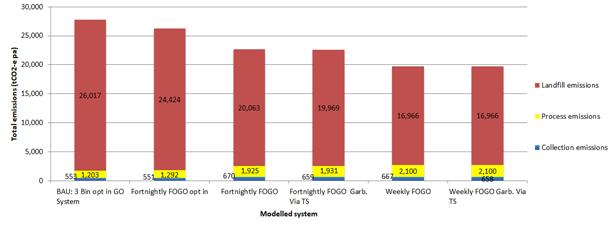 Kitchen Caddies and Compostable
liners
Kitchen Caddies and Compostable
liners
Results of food
waste diversion from landfill by other FOGO councils and social research
conducted within metropolitan Melbourne shows the easiest use and best results
are achieved when households are provided with a kitchen benchtop caddy and
compostable liners. Food waste can be placed directly into the caddy,
separating it from other waste placed in the garbage bin. This also removes
some of the ‘yuck’ factor when dealing with food waste, which is
often a barrier to households utilising the service. Some processing
technologies and facilities are unable to break down compostable bags or liners
which has resulted in some councils not having this option. Council’s
processing contractor has confirmed they will be able to accept an approved
compostable liner.
Diversion from
landfill further increases when garbage bins are collected fortnightly and FOGO
collected weekly. The best FOGO service to date from a Victorian council are
those with both a kitchen caddy and liners provided, along with a weekly FOGO
service and fortnightly Garbage service.
Table 2. Waste to landfill diversion achieved in
Victoria with caddies and liners
|
Council
|
System
|
Diversion from landfill
|
|
Bass Coast Shire Council
|
Weekly FOGO (caddies & liners)
Fortnightly Garbage
Fortnightly Recycling
|
77.2%
|
|
Wodonga City Council
|
Weekly FOGO (caddies & liners)
Fortnightly Garbage
Fortnightly Recycling
|
71.43%
|
Table 3. Waste to landfill diversion achieved in
Victoria with no caddies and liners
|
Council
|
System
|
Diversion from landfill
|
|
Wyndham City Council
|
Fortnightly FOGO
Weekly Garbage
Fortnightly Recycling
|
35.78%
|
|
Moonee Valley City Council
|
Fortnightly FOGO (caddies only)
Weekly Garbage
Fortnightly Recycling
|
41.67%
|
|
Colac Otway Shire Council
|
Fortnightly FOGO (caddies only)
Weekly Garbage
Fortnightly Recycling
|
47.79%
|
Diversion rates further increase
when caddies and liners are used in combination with weekly FOGO services:
· Weekly
FOGO service (with caddies and liners) and fortnightly garbage service –
average landfill diversion rate 62.81%.
· Fortnightly
FOGO service (with caddies and liners) and weekly garbage service –
average landfill diversion rate 55.28%.
FOGO implementation
In order to
divert the most waste from landfill, reduce emissions and have a FOGO
collection widely accepted and used by the community, a phased approach to
delivering a FOGO service is recommended. This includes the first step of
including food waste in the current garden organics service in years 1-3 of the
new waste contract and then transitioning to a universal or compulsory food waste
service weekly, with the garbage collected fortnightly in year 4 of the
contract. This will allow those in the community already keen for a food waste
collection to start participating, while allowing Council to trial and refine
the service further before making it universal/compulsory. This is especially
important in areas with lots of apartments and unit dwellings where space for
bins may be an issue, to properties that currently don’t have a garden
bin, and to households where it may be more difficult to communicate with,
including where English is not a first language.
Figure 2. Progression of FOGO
service implementation
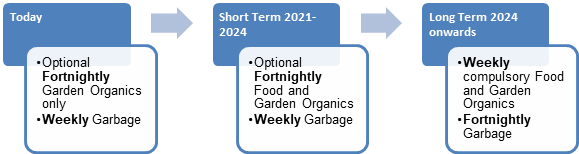
A compulsory (universal) weekly
FOGO service from commencement of the new kerbside contracts is not recommended
for the following reasons:
· Increased
contamination, as it is a big adjustment for residents to adapt to
· Difficulties
for larger families ie. nappies, larger household waste volumes.
A trial run before a full roll-out will allow us to
understand the FOGO implementation challenges specific to Whitehorse, identify
any gaps or issues raised by the community who are not used to using an
organics bin, and prepare Council staff and resources for the full roll-out.
This will also allow time for Council to address charging of waste and any
larger bin roll-outs that may be required. Residents will gain prior notice of
Council’s intent to introduce the service and provide a focus point for
community discussion and feedback. The new waste contract specifications will
request rates for both fortnightly and weekly garbage and FOGO collections to
accommodate possible future changes.
Table 4. Waste contract procurement and FOGO timeline
|
February 2020
|
• Waste
contract procurement plan
• Waste
contracts probity plan
• FOGO
implementation plan
• Finalisation
of tender specifications
|
|
End of March 2020
|
• Waste
and recycling contracts tender advertised
|
|
April 2020
|
• Waste
and recycling contracts tender open
• FOGO
communication plan
|
|
May 2020
|
• Waste
and recycling contracts tender close
• Contract
tender evaluation commences
|
|
June- July 2020
|
• Waste
and recycling contracts tender evaluated
|
|
August/ September 2020
|
• Council
consideration of tender outcome and FOGO provisions, and contract award
|
|
November 2020 – June 2021
|
• Preparation
for new contracts
• Ordering
trucks, FOGO caddies, Liners
• Roll
out FOGO community education
· FOGO
‘before’ Spring compositional bin audits
|
|
May 2021
|
• FOGO
‘before’ Autumn compositional bin audits
|
|
1 July 2021
|
• Start
of new waste contracts including optional FOGO
|
|
August/September & November 2021
|
• FOGO
‘after’ Spring compositional bin audits
|
|
May 2022
|
• FOGO
‘after’ Autumn compositional bin audits
|
|
July 2022 – July 2024
|
• FOGO
trials in multi-unit and Culturally and Linguistically Diverse areas
|
|
1 July 2024
|
• Possible
introduction of compulsory/universal fortnightly FOGO services
|
Bin audits and data collection
Council’s last compositional
bin audits which scientifically calculate the waste contents of the three
different types of kerbside bins was in 2015. In order to track the success of
the service changes in 2021, a series of ‘before’ and ‘after’
compositional bin audits are required. Detailed analysis of a sample of the
actual bin contents will help to identify where there is a need for
improvement, how the community is responding, and help to prepare community
education and possible further service tweaks.
Waste generation by households
changes over time, as do the types and proportion of waste. This includes
seasonal changes from summer to winter periods, especially with organic
material. It is proposed that ‘before’ audits be conducted in November
2020 (spring), then again in May 2021 (autumn) to account for the seasonal
changes ahead of the FOGO implementation, then in August or September 2021 to
track progress in the first couple of months after the change to opt in FOGO,
then again in November 2021 and May 2022 to allow for comparison with the
previous year data. Further audits would be needed ahead of any further changes
to a compulsory FOGO service expansion and in areas participating in any
trials.
CONSULTATION
Extensive community consultation
was undertaken in developing Council’s Waste Management Strategy
2018-2028. There was strong community endorsement for introducing a food
organics and garden organics service, as well as continuing to support
recycling.
When the new waste and recycling
collection contracts commence on 1 July 2021, residents should experience a
seamless change to the new kerbside waste and recycling collection services and
have an option for a new food into the garden organics bin if they opted into
this service. This aligns with the expectations raised during the community
consultation process.
A comprehensive implementation
plan, incorporating a communications plan, will be established to support
residents to use the new food in the green organics bin service. The plan will
provide guidance from 12 months before the program begins through to
post-implementation. It draws upon findings from MWRRG, Victorian and New South
Wales councils and Community-Based Social Marketing behaviour change theory.
A communications plan will be developed
along with the Communications team and Knox City Council who are planning a
similar FOGO service at the same time as Whitehorse, to support the various
stages of the plan. This will ensure a regional consistent approach and cost
savings on producing materials. The implementation plan will be
implemented with support from the MWRRG, Sustainability Victoria and other
Council teams.
The procurement plan for the waste
and recycling collection contracts has been developed in conjunction with
Council’s Finance team. The Procurement and Finance teams will be an
integral component providing procurement support and advice during the tender
process.
FINANCIAL
IMPLICATIONS
The kerbside waste and recycling
collection contracts are amongst the largest service contracts awarded by
Council, due to their scope and up to 10-year duration. The contracts require
the contractor to supply new trucks from the commencement of the contract,
which is a substantial up-front capital investment by the contractor. These
costs are typically amortised over the duration of the contract, making it more
affordable by Council to set a minimum 7-year core contract period.
The waste and recycling industry is
facing significant issues that are likely to drive the cost of providing waste
and recycling collections up by much more than CPI for the next suite of
kerbside collection contracts. The extent of the increase is not able to be
estimated at this time.
The annual value of the current waste
and recycling collection contracts is as follows:
Garbage collections $3.43M
p.a
Recycling collections $1.93M
p.a
Garden organics collections (*FOGO costs will likely be higher) $1.31M
p.a
Hard waste collections $1.88M
p.a
Total $8.55M
p.a
The overall projected expenditure
for the next suite of kerbside waste and recycling contracts over the core term
plus possible extensions (ie. 10 years) is anticipated to be at least
$94M. (Excludes glass recycling costs)
These services are envisaged to be
part of a possible separate waste services charge in the future , with
participating households paying a separate waste charge that covers the cost of
these services. The service packages will vary depending on which services are
used by the community.
The additional cost to provide a
FOGO service will have some offsetting savings as the amount of garbage going
to landfill that contains food waste reduces. The overall service cost is
expected to increase when the FOGO service is extended to become universal or
compulsory on a weekly basis, however the modelling shows that the cost per
household remains affordable. The FOGO service will not capture all of the food
waste, but it is expected to capture a significant proportion of food waste
that currently goes to landfill.
The cost of processing combined
food and garden organics is currently less than the cost of sending food waste
to landfill. The savings compared with landfill will increase over time because
the cost of landfill will rise substantially in coming years, while the organics
processing cost is fixed under contract until 2030.
On Wednesday 26 February 2020, The
Honourable Lily D'Ambrosio MP, Minster for Energy, Environment and Climate
Change, released the Victorian Government's 10-year policy and action plan
(Plan) for waste and recycling known as Recycling Victoria. The Plan
provides a platform to reform the recycling system by transforming how
household recyclable material is recycled for reuse and outlines the landfill
levy increases over the next 3 years.
The Plan provides four ambitious
new targets as follows:
1. Divert
80 per cent of waste from landfill by 2030, and an interim target of 72 per
cent by 2025.
2. Cut
total waste generation by 15 per cent per capita by 2030.
3. Halve
the volume of organic material going to landfill between 2020 and 2030, with an
interim target of 20 per cent reduction by 2025.
4. Ensure
every Victorian household has access to food and garden organic waste recycling
services or local composting by 2030.
The Victorian landfill levy is currently
one of the lowest across Australia. Through its Plan, the Victorian Government
has increased the landfill levy over the next 3 years to align it with other
states thereby preventing Victoria from becoming the dumping ground for waste.
Currently Victoria’s landfill levy is $65.90 per tonne compared with
landfill levy in NSW and South Australia at around $140 per tonne. The
metropolitan landfill levy will increase $20/tonne per year over the next 3
years, commencing in FY 2020/21 through to 2022/23. The Victorian
landfill levy increase recognises the social, economic and environmental value
of recycling and supports a shift to a circular economy. Every $10 per tonne
increase in the landfill levy will add approximately $280k per annum to Council’s
kerbside garbage disposal costs, unless a significant garbage tonnage reduction
can be achieved with FOGO.
Upfront costs of FOGO
Introducing a FOGO service requires
an upfront cost to supply kitchen caddies and liners and additional education
material and activities to all participating households. A further capital cost
is incurred when the optional FOGO service is extended to become universal or
compulsory to all households, because of the need to supply the additional
organics kerbside bins to those not already using the garden organics service.
Currently, about 43,800 households use the garden organics service, so an
estimated 20,000 to 25,000 additional FOGO bins would be needed for a universal
service.
A common practice is to require
service providers to amortise bin roll-out costs over the entire contract
period for newly introduced services. Conversations with Knox Council indicate
a willingness to share education resources and possibly combine roll-out of any
caddies and liners through a shared supply contract. Providers of both the
caddies and liners have advised a collaborative tender between both Knox and
Whitehorse would bring significant savings from initial indicative costs
provided. This would not be possible with a contract amortised arrangement,
however amortisation spreads the upfront cost over time.
An estimate of the annual repayments
using the amortised approach is approximately $195,000 per year for 7 years
from 1 July 2021. This is compared with an estimated one-off upfront payment of
$1.03M for a separate roll-out project in early 2021 prior to FOGO service
commencement.
The FOGO tender documents will seek
tender costings for each of these funding options.
Total Kerbside Waste and Recycling Service costs
A detailed evaluation of the various service options and
costs, including FOGO will be reported to Council in August/September 2020,
based on the waste contract tender outcomes. This will include a comparison
with Council’s existing kerbside collection service costs and an indication
of the service costs over the 10-year contract period.
POLICY IMPLICATIONS
Council adopted
the ten year Rubbish to Resource! Waste Management Strategy 2018-2028 in December
2018. The strategy identifies further Council actions for minimising waste to
landfill and maximising resource recovery, and the need for continual
improvements to Council’s Kerbside waste and recycling services. This
includes the implementation of a kerbside Food Organics and Garden Organics
(FOGO) service from 2021. The new FOGO service, in addition to the existing
kerbside services could potentially help to boost diversion from landfill
considerably, meeting Councils target of 60% diversion by 2023.
A FOGO service
also aligns with Council’s Sustainability Strategy 2016-2022 and emissions
reduction efforts to be carbon neutral by 2022.
Ordinary Council Minutes 16
March 2020
Business and Economic Development
9.1.9 Investment
and Economic Development Strategy Extension 2020-2022
ATTACHMENT
SUMMARY
Building on the
success of the Whitehorse Economic Development Strategy 2014-2019, the
Whitehorse Investment and Economic Development Strategy Extension 2020-2022 has
been prepared to continue Council’s role is guiding continued business
and employment activity to support a strong economic future for the City of
Whitehorse.
The Economic Development Strategy
Extension 2020-2022 seeks to affiliate with the timing of the next
Whitehorse Council vision and plan. The purpose of the report is to seek
Council’s support to release the Economic
Development Strategy Extension 2020-2022 for public consultation.
|
Council
Resolution
Moved by Cr Liu, Seconded
by Cr Davenport
That Council approve the release of the
Investment and Economic Development Strategy 2020-2022 extension for public
consultation in April 2020.
Carried
A Division was called.
Division
|
For
Cr
Bennett
Cr
Carr
Cr
Ellis
Cr Liu
Cr
Massoud
Cr
Munroe
Cr
Stennett
|
Against
Cr
Barker
Cr
Davenport
|
On
the results of the Division the motion was declared carried
|
background
Legislative Framework
The Investment and Economic
Development Strategy Extension (I&EDSE) 2020-2022 considers the primary
economic objectives under the Local Government Act 1989 Part
1A, Section 3C, items 2 (a), (c) and (d). In seeking to achieve the
primary objective of a council and in accordance with the Local Government
Act 1989 (the Act), a council must have regard to the following objectives:
· To
promote the social, economic and environmental viability and sustainability of
the municipal district;
· To
promote appropriate business and employment opportunities;
· To
improve the overall quality of life of people in the local community.
In seeking to achieve these
objectives, the role of council is further specified within the Act as
providing leadership by establishing strategic objectives and monitoring their
achievement.
DISCUSSION
The Economic Development Strategy 2014-2019
has delivered a number of successful programs and projects and recent
highlights include: Whitehorse Business Week, Mitcham Mall activation, Box Hill
Logo competition, Industrial Precinct Economic Review and hosting the
Mainstreet Australia Conference.
The I&EDSE 2020-2022 aims to
expand on the Economic Development Strategy 2014-2019 and seeks to update,
simplify and better align with current and future trends. Importantly,
the I&EDSE 2020-2022 seeks to affiliate with the timing of the next
Whitehorse Council vision and plan.
The I&EDSE 2020-2022 will come
under the Whitehorse Council Plan 2017-2021 Strategic Direction 5: Support a
healthy local economy.
CONSULTATION
SGS Economics and Planning were
engaged to perform an economic analysis of the Whitehorse economy to form part
of the I&EDSE 2020-2022.
The draft Strategy has been
informed by preliminary consultation with selected internal stakeholders from
the following areas:
· Investment
& Economic Development Ÿ Arts and Culture
· Sustainability Ÿ Engineering &
Environmental Services
· Community
Development Ÿ Strategic Marketing and
Communications
· Strategic
Planning Ÿ Leisure and Recreation
· Urban
Design Ÿ Finance and Corporate
Performance
The following external benchmarking
was conducted as part of the preliminary consultation process:
· Biennial
Business Performance Survey (2019) and Whitehorse Industrial Precinct Survey
(2019)
· Maroondah
Council: BizHub
· Desktop
research of economic development strategies from various local government
authorities and education institutions
· Melbourne
East Regional Economic Development Group and Eastern Region Executive Group
values and directions were considered.
The proposed external consultation
will include but not be limited to a Leader advertisement, social media posts,
Down to Business newsletter advertisement and notifications to Boost program
participants, Whitehorse Business Group members, precinct trader associations
and key business stakeholders.
FINANCIAL
IMPLICATIONS
The development of the I&EDSE
2020-2022 has been funded through the Investment & Economic Development
Unit’s 2019/2020 operational budget.
All actions detailed in the I&EDSE 2020-2022 will be
funded through the recurrent budget over the next two years. Any
actions/projects that require funding beyond the budget will be obtained
through partnerships and private/public sector stakeholders through grant
programs and sponsorship.
|
|
Budget
|
Expenditure
|
|
Advertisement
in the Leader
|
1000
|
|
|
Down to
Business
|
0
|
|
|
Social
Media Posts
|
0
|
|
|
Direct
notification to identified stakeholders
|
0
|
|
|
|
|
|
|
Total
Budget
|
1000
|
|
|
|
|
|
POLICY IMPLICATIONS
The I&EDSE2020-2022 is prepared
to outline the role Council provides in business and employment activity to
continue to support a strong economic future for the City of Whitehorse.
Attachment
1 Draft Extension
Strategy 2020 - 2022 
Ordinary Council Minutes 16
March 2020
9.2 Human
Services
9.2.1 Nunawading
Hub Fees and Charges
SUMMARY
The purpose of this report is to advise of the new fees
and charges for the tenant and general user groups for use of the new
Nunawading Community Hub.
|
Council
Resolution
Moved by Cr Stennett,
Seconded by Cr Munroe
That Council:
1. Having
considered the proposed schedule of fees and charges for the Nunawading Hub,
include the list of fees and charges in Council’s Draft Budget 2020/21.
2. Note
Licence Agreements will be developed for Nunawading U3A and Whitehorse Arts
Association.
CARRIED
UNANIMOUSLY
|
background
Nunawading Community Hub (NCH) is
currently under construction at the site of the old Nunawading Primary School
and is due to be completed mid-2020. NCH will accommodate a variety of
community and sporting groups currently operating out of the Nunawading Community
Centre and the Silver Grove precinct, including Nunawading U3A (U3A),
Whitehorse Arts Association (WAA), Nunawading Lapidary Club (NLC), Eastern
Access Community Health (EACH) and the Blackburn Vikings Basketball Association
(BV).
NCH will consist of a single court
multipurpose indoor stadium, multi-functional classrooms and meeting rooms,
specially fitted out spaces for dance, art counselling and lapidary activities
and a communal kitchen with teaching area. Council’s Meals on Wheels
service will also be accommodated within the new facility. NCH will also
provide users with a carpark for 200+ vehicles.
The Nunawading Community Hub will
accommodate existing Nunawading Community Centre and Silver Grove precinct user
groups and will have scope to provide spaces for hire to other Community and
Sporting user groups.
DISCUSSION
Council officers undertook an
investigation as to a fee model and occupancy arrangements that is fair,
accessible and sustainable for the existing and future users of the Hub. In
recommending a schedule of fees and charges, consideration was given to the following
parameters:
Benchmarking – across
Whitehorse departments and like Councils.
Existing financial arrangements
– the NCH will accommodate existing community user groups that have
current and historical fees and leases in place.
· The
higher profile of the NCH – the current Silver Grove user groups are
accommodated in outdated separate spaces and buildings. The NCH will be a
large, state of the art new building on Springvale Road. It is expected
to attract considerable attention from the local and broader community due to
its location and size.
· Community
relationships and history.
· Financial
means (capacity to pay) for community groups.
The proposed
categories of hire are as follows:
1. Standard Rate – any organisation or
individual who are not registered as a not for profit group. This includes user
groups not based within Whitehorse.
2. Whitehorse Community Rate – Whitehorse based
groups that are classified as not for profit
NB: Eligible
not for profit groups are required to be legally registered as a Charity or an
Incorporated Association and can include Non-Government Organisations.
3. Seniors Rate – seniors groups whose
membership is open to people 60 years and over and/or have the words elderly in
their name. This must be specified in the organisation’s rules or
constitution and/or their advertising.
Room Hire Rates
A schedule of rates for the various rooms within the
NCH has been devised applying a base rate of 50c per square metre as the
standard rate. The Whitehorse Community Rate is calculated at a 50% discount on
the Standard rate. No distinction will be made between regular or casual
hirers.
Most current user groups are expecting to pay a higher
room hire rate in the new facility.
The table below compares the difference between the
current and proposed rates for existing user groups.
|
Community Group
|
Current Fee at Existing
Venues
|
Anticipated
hours per week (p/w)
Nunawading
Hub
|
NCH Room Rate/ Hr
|
No of Weeks
|
NCH Total
|
Difference b/n current
& anticipated cost
|
|
*JCH Round Dancing
|
$20/hour
|
Dance
Space 4.5 hrs p/w
|
$41
|
40
|
$7,380
|
$3,780
|
|
*JCH Cultural Dancing
|
$20/hour
|
Dance
Space
2
hrs p/w
|
$41
|
40
|
$3,280
|
$1,680
|
|
*Rock City Church
|
$20/hour
|
Dance
Space 5 hrs p/w
|
$41
|
52
|
$10,660
|
$5,460
|
|
*Whitehorse Square
Dancing
|
$20/hour
|
Dance
Space 3 hrs p/w
|
$41
|
40
|
$4,920
|
$2,520
|
|
*Qing Yin Dance Club
|
$20/hour
|
Dance
Space
1.5
hrs p/w
|
$41
|
40
|
$2,460
|
$1,260
|
|
Arts Nunawading
|
$14 p/h
|
Meeting
Rm 2
1
hr p/w
|
$15
|
|
|
+ $1
|
|
Victory Life Ministry
|
$28 p/h
|
Meeting
Rm 2 1hr p/w
|
$15ph
|
|
|
-$13
|
*Currently use Jaycees Hall in Silver
Grove
The
following groups are currently paying the seniors rate, therefore there will be
no change at the new Hub as they will remain on the seniors rate –
Whitehorse Activities Club, Chinese Women’s Association and Liangmeng
Aushina Seniors Choir.
It is proposed that there is a
three-year transition to pay the full new room rates so that by year 3 all
groups are paying the proposed Whitehorse community rate.
Groups Requiring Special
Consideration
U3A Nunawading will be one of the primary
tenants of Nunawading Community Hub. Special consideration is required in
relation to the occupancy arrangements for U3A Nunawading given the significant
number of hours used by the group. The group have approximately 2,000
members and offer approximately 220 hours of activity from Silver Grove venues
each week excluding stadium use.
U3A Nunawading currently uses the
following venues in addition to Nunawading Community Centre. These
include the Seniors Hall, Seniors Meeting Room, Jaycees Hall, Anglers Club and
Building 14 in Silver Grove. The group also use a range of facilities outside
the Silver Grove precinct including a Computer Centre in Mahoneys Road, Forest
Hill, AdventCare Activity Centre, Eley Park Community Centre (for Tai Chi),
table tennis at Kilsyth Sports Stadium, Bowls at Blackburn Bowls Club, Golf at
Morack Public Golf Course and Regis Aged Care for exercise classes. U3A spent
$42,290 on room hire in 2018/19.
It is proposed that Council enter
into a Licence Agreement with U3A as an ‘anchor’ tenant with the
fee set at $50,000 in Year 1. Whilst this fee is slightly more than what
the group are currently paying for use of Nunawading Community Centre and
Silver Grove precinct facilities, given the surplus generated each year by the
group and in light of the higher quality facilities, it is felt this is well
within the capacities of the organisation to meet this fee.
WAA currently has exclusive use of
some rooms for an annual fee at Nunawading Community Centre. Under the
proposed fees and charges structure for the NCH, they would not be able to
afford to pay by the hour for their usage therefore it is proposed that a
Licence Agreement also be entered into with WAA (also an anchor tenant). The
fee would be $4,200 in Year 1. Whilst this fee is slightly more than what the
group are currently paying for Silver Grove precinct facilities ($4,070), it is
felt this is reasonable given the group are anticipating fee increases.
The above Licence Agreements would
include a schedule of prescribed usage and any room hire over and above this
schedule would be charged at the Whitehorse Community Rate. Both the U3A and
WAA fees would be subject to annual increases in line with CPI. The term
of the Licence Agreements will be for a 3 year period with an annual increment
of 4% in accordance with Council’s Property Lease and Licence Policy.
Legal advice from Maddocks Lawyers
confirms that the proposed Licence Agreements require exemption via a Council
resolution if a different pricing schedule is to be adopted to that specified
within Council’s Property Lease and Licence Policy. The fees
proposed for U3A and WAA provide flexibility and are commensurate with the fees
both groups are paying at present.
Stadium Hire Rates
The stadium hire rates at NCH will be consistent with
all stadium hire rates across Whitehorse Council operated facilities. The
single court at Nunawading Community Centre is not a full sized compliant court
therefore the proposed fee is reflective of a full sized modern compliant
court. The percentage fee increase will be between 12%-29% for current groups
as outlined in the table below.
|
Community
Group/Individual
|
Current
Fee/ Hr
|
Hours
of Use – Peak/ Off Peak Per Week
|
Proposed
NCH Fee/ Hr
|
|
Blackburn Vikings
Basketball Association
|
$45.00
|
13 hours - peak
|
$58.00
|
|
Chevaliers Fencing
|
$45.00
|
4 hours - peak
|
$58.00
|
|
Social Group A
|
$45.00
|
2 hours - peak
|
$58.00
|
|
Social Group B
|
$45.00
|
2 hours - peak
|
$58.00
|
|
Thornburn Ladies’
Badminton
|
$38.00
|
5.5 hours - off peak
|
$43.00
|
|
Social Badminton
|
$38.00
|
7 hours - off peak
|
$43.00
|
|
JT Ultra Badminton
Association
|
$45.00
|
6 hours - peak
|
$58.00
|
|
Zoroastrian Association
of Vic.
|
$16.00
|
2 hours - peak
|
$22.00
|
|
Social Group C
|
$45.00
|
I hour - peak
|
$58.00
|
|
Social Group D
|
$45.00
|
I hour - peak
|
$58.00
|
|
Westside Badminton
|
$16.00
|
I hour - peak
|
$22.00
|
|
Social Group E
|
$38.00
|
1.5 hours - peak
|
$43.00
|
|
Social Group F
|
$45.00
|
3 hours - peak
|
$58.00
|
|
Social Group G
|
$45.00
|
I hour - peak
|
$58.00
|
|
Social Group H
|
$16.00
|
2 hours - peak
|
$22.00
|
|
Social Group I
|
$45.00
|
2 hours - peak
|
$58.00
|
It is proposed that the new stadium fee is implemented
over a two year period.
Lease Arrangements
There are two external groups that
will exclusively occupy space within the NCH. The groups are NLC and U3A.
NLC is a member based not for
profit club that is financially self-supporting that caters generally to
its own interest group and have been assessed as a Category 2 tenant according
to Council’s Property Lease and Licence Policy. A lease fee of $4,808 per
annum plus GST would be applicable for their purpose built space within the
NCH.
U3A have been assessed as a
Category 2 tenant according to Council’s Property Lease and Licence
Policy. A lease fee of $1,012 per annum plus GST would
be applicable for their 47.4m²
office space.
The NLC and U3A leases will be for
a term of 9 years with an annual 4% increment in accordance with
Council’s Property Lease and Licence Policy.
CONSULTATION
Benchmarking with neighbouring
Councils was undertaken and the findings were used as the basis for workshops
with relevant Council Officers from Community Development and Leisure and
Recreation Services.
Legal advice was sought from Maddocks Lawyers in relation to
the draft fees and charges and implications in relation to Council’s
Property Lease and Licence Policy, retail Leases Act 2003 and S190 of the Local
Government Act 1989.
FINANCIAL
IMPLICATIONS
The 2020/21 NCH fees and charges schedule is based on the
following assumptions:
· Existing
users from the Nunawading Community Centre and Silver Grove precinct will
transfer their activities to NCH.
· The
fees for the existing users are scaled up over 3 years for room hire and 2
years for stadium use/hire.
· New
users will hire the facilities at the scheduled rates.
POLICY IMPLICATIONS
The proposed Licence arrangements
for U3A Nunawading and Whitehorse Arts Association sit outside Council’s
Property Lease and Licence Policy and require an exemption via a Council
resolution.
Ordinary Council Minutes 16
March 2020
9.2.2 Intention
to Lease East Burwood and Mitcham Tennis Clubs
SUMMARY
Council has two tennis club leases they
being East Burwood Tennis Club and Mitcham Tennis Club that have expired and
are now on overhold. A new lease has been prepared for the two clubs. The
leases have been prepared based on a term of eleven years and four months with
no further option periods subject to sections 190 and 223 of the Local
Government Act 1989.
|
Council
Resolution
Moved by Cr Carr,
Seconded by Cr Stennett
That Council:
1. In accordance with sections 190 and 223 of
Local Government Act 1989, give notice of Council’s intention to lease
the land know as:
· East Burwood Tennis Club located at 300 Burwood Highway, Burwood
East, and;
· Mitcham Tennis Club located at 68 Dunlavin Road, Nunawading
for a total lease term of
eleven years and four months with no further option periods, with a proposed
commencement date of 1 June 2020.
2. Authorise the
Manager of Property & Rates to undertake the administrative procedures
necessary to enable Council to carry out its functions under Sections 190 and
223 of the Local Government Act 1989, in relation to these matters.
3. Appoints Council’s Special Committee to consider
and hear any submissions at the meeting to be held at Whitehorse Civic Centre
Council Chamber 379-397 Whitehorse Road, Nunawading on Monday 11 May 2020 at
7:00pm.
Carried Unanimously
|
background
Council has two tennis club
leases they being East Burwood Tennis Club and Mitcham Tennis Club that have
expired and are now on overhold. A new lease has been prepared for the two
clubs. The leases have been prepared based on a term of eleven years and four
months with no further option periods subject to sections 190 and 223 of the
Local Government Act 1989.
DISCUSSION
There are currently ten active
tennis clubs and one combined tennis and bowls club operating on Council land
across the municipality. Bluebell Hill Tennis Club’s lease expires in
March 2025 and the further eight clubs have leases which expire in September
2031. All with no further option periods subject to sections 190 and 223 of the
Local Government Act 1989.
This report addresses the final two
clubs, East Burwood and Mitcham Tennis Clubs both of which require a new lease.
New leases have been prepared with a term of eleven years and four months with
no further option period subject to sections 190 and 223 of the Local
Government Act 1989. This aligns with the remaining terms of the above
mentioned eight clubs to allow a consistent management approach.
Officers have developed the new
lease and maintenance schedule based on Council’s standard template which
are consistent with the other tennis club leases. They are both a category two
tenant land and building lease.
The rental schedule, which is
discussed below, includes phasing in year 1 and 2 which is in line with
Council’s Property Lease and Licence Policy (The Policy).
Governance Requirements
In accordance with sections 190 and
223 of the Local Government Act 1989, if Council desires to enter into a lease
for 10 or more years (including option periods) it must give public notice of
its intention to lease land.
Pursuant to section 223 (1) of the
Local Government Act 1989, Council will consider and, if required, hear any
submissions received in regard to the proposal to lease the land.
Key processes that are proposed if endorsed
by Council are:
· Saturday
21 March 2020: Public Notice advertisement (In the Age newspaper and on
Council’s website)
· Monday
20 April 2020: Public submissions close
· Monday
11 May 2020: Special Committee to hear any submission/s (if required)
· Monday
25 May 2020: Report to Council for consideration
CONSULTATION
East Burwood Tennis Club and
Mitcham Tennis Club representatives have been consulted as part of the lease
preparations. Officers from Council’s Leisure and Recreation Services and
Property and Rates Department met with East Burwood on Thursday 16 January 2020
and Mitcham on Wednesday 5 February 2020.
Key points from each lease were
discussed in the meeting and the clubs were provided with draft leases and
maintenance schedules to take and discuss with their committees. Meetings
were positive and both clubs have advised they are comfortable to enter into a
new lease agreement.
A public notice advertising
Council’s intention to lease the properties for a period of eleven years
and four months with no further options will be placed in the Saturday edition
of The Age on Saturday 21 March 2020.
The public notice gives the general
public 28 days from the date of the notice to make a written submission. Any
person making a submission and requesting to be heard in support of their
written submission is entitled to appear in person, or may be represented by a
person acting on their behalf.
FINANCIAL
IMPLICATIONS
The rental fees over the eleven years and four month term for
each respective club is outlined below. The rents have been worked out based on
the number of courts occupied and have parity with the eight tennis clubs that
have been granted leases.
|
|
East Burwood Tennis Club
|
Mitcham Tennis Club
|
|
Year 1*
|
$185
|
$110
|
|
Year 2*
|
$370
|
$220
|
|
Year 3
|
$560
|
$330
|
|
Year 4
|
$580
|
$340
|
|
Year 5
|
$600
|
$350
|
|
Year 6
|
$625
|
$370
|
|
Year 7
|
$650
|
$390
|
|
Year 8
|
$675
|
$410
|
|
Year 9
|
$700
|
$430
|
|
Year 10
|
$725
|
$450
|
|
Year 11
|
$750
|
$500
|
* Year 1 and 2 are phased
rates.
The estimated cost associated with
administering the process outlined in Section 190 of the Local Government Act
is $7,500 + GST. This amount can be found within existing budget.
POLICY IMPLICATIONS
Council Property Lease and Licence
Policy (April 2012).
Local Government Act (1989).
Ordinary Council Minutes 16
March 2020
9.3 Corporate
Procedural Motion
Moved
by Cr Barker, Seconded by Cr Davenport
That report items
9.3.1, 9.3.2 and 9.3.3 be considered together and the recommendations adopted.
CARRIED UNANIMOUSLY
9.3.1 Intention
to Lease Land 96-106 Springvale Road, Nunawading
FILE NUMBER: SF08/271
SUMMARY
This report advises Council of a proposed
lease option term being added to an existing substation lease over part of the
Council owned land known as the Nunawading Hub located at 96-106 Springvale
Road, Nunawading and to authorise the statutory process in accordance with
Section 190 of the Local Government Act 1989.
|
Council
Resolution
Moved by Cr Barker,
Seconded by Cr Davenport
That Council:
1. In
accordance with Sections 190 and 223 of the Local Government Act 1989, give
notice of Council’s intention to grant a further term of twenty (20)
years via a “Deed of Variation” to the existing thirty (30) year
lease for part of the land known as 96-106 Springvale Road, Nunawading to United
Energy Distribution Pty Ltd with a nominal annual rental of one dollar ($1),
if demanded, and with a commencement date of 22 March 2049.
2. Authorise the Manager of Property & Rates to undertake the
administrative procedures necessary to enable Council to carry out its functions
under Section 223 of the Local Government Act 1989, in relation to this
matter.
3. Appoints Council’s Special Committee to consider and hear
any submissions at the meeting to be held at Whitehorse Civic Centre Council
Chamber 379-397 Whitehorse Road, Nunawading on Monday 11 May 2020 at 7:00pm.
Carried Unanimously
|
background
At Council's
ordinary meeting of 10 December 2018 Council considered and resolved the
following:
“That Council:
1. Having completed the public
notice process in accordance with Sections 190 and 223 of the Local Government
Act 1989 and having received no submissions, resolve to grant a lease over part
of the Council owned land known as the Nunawading Hub located at 96-106
Springvale Road, Nunawading to United Energy Distribution Pty Ltd for a total
lease term of thirty (30) years, with a nominal annual rental of one dollar
($1), if demanded, and with a proposed commencement date of 1 December 2018.
2. Authorise
the Manager of Property & Rates to sign the lease.”
The thirty (30) year lease (the
lease) granted by Council on 10 December 2018 related to a new substation being
located on Esdale Street, the substation provides electricity to the Nunawading
Hub located at 96-106 Springvale Road, Nunawading.
Both Council and United Energy have
signed the lease.
However, since signing the lease
United Energy, via their lawyers, have requested an option for a further term
of twenty (20) years via a “Deed of Variation” be added to the
lease.
Given that the substation is
required to provide electricity to the Nunawading Hub, Council Officers
recommend granting the additional twenty (20) years.
Council’s Lawyers, Maddocks,
have verbally advised that because the proposed option term is longer than ten
years, Section 190 of the Local Government Act 1989 (the LGA) applies.
Section 190 of the LGA states the
following:
“Restriction on power to
lease land:
1) A
Council's power to lease any land to any person is limited to leases for a term
of 50 years or less.
2) Subject
to any other Act, if a Council leases any land to any person subject to any
exceptions, reservations, covenants and conditions, it must comply with this
section.
3) If
the lease is to be-
a) For
1 year or more and-
i. The
rent for any period of the lease is $50 000 or more a year; or
ii. The
current market rental value of the land is $50 000 or more a year; or
b) For
10 years or more; or
c) A
building or improving lease-the Council must at least 4 weeks before the lease
is made publish a public notice of the proposed lease.
4) A
person has a right to make a submission under section 223 on the proposed
lease.”
DISCUSSION
The proposed further term of twenty
(20) years will be an option term exercised at the discretion of United Energy Distribution Pty Ltd; the option term will
commence at the expiry of the lease. The lease was fully executed on 22
March 2019 and consequently, the option period will commence on 22 March 2049,
expiring on 21 March 2069.
Given that Council and United Energy Distribution Pty Ltd currently have an agreed lease
for the substation, it is recommended that subject to the completion of the
required statutory obligations mentioned above and below that the twenty (20)
year option term be added to the lease via a “Deed of Variation”,
rather than the parties negotiating a new lease.
It is important to
note that the “Deed of Variation” will only add the twenty year
(20) option term, it will not change the terms of the lease.
Governance Requirements
In accordance with Sections 190 and
223 of the LGA shown above, if Council proposes to enter into a lease for 10 or
more years (including option terms) it must give public notice of its
intention.
Pursuant to Section 223 of the LGA,
Council will consider and, if required, hear any submissions received in regard
to the proposal to lease the land.
Key processes that are proposed if
endorsed by Council are:
· Saturday
21 March 2020: Public Notice advertisement (In the Age newspaper
and on Council’s website)
· Monday
20 April 2020: Public
submissions close
· Monday
11 May 2020: Special
Committee to hear any submission/s (if required)
· Monday
25 May 2020: Report
to Council for consideration
CONSULTATION
The public notice gives members of
the public the opportunity to make a written submission regarding
Council’s proposal to increase the lease term by twenty (20) years.
In accordance with Section 223 of
the LGA, a person making a written submission has the right to request to be
heard by the Committee of Council, appointed to consider and hear submissions.
Additionally, the public notice
will be displayed on Council’s website for the duration of the twenty
eight (28) day public notice period.
FINANCIAL
IMPLICATIONS
The substation was constructed at Council’s request,
meaning that Council is the primary beneficiary of the substation.
Consequently, it is deemed appropriate that the rent payable under lease, for
the duration of the initial lease term and the proposed option period be a
nominal rent of one dollar ($1) per annum, if demanded.
All expenses associated with the lease and the statutory
process will be borne by the Property & Rates Department’s 2019/20
recurrent budget and these expenses are estimated to be approximately $10,000 +
GST.
POLICY IMPLICATIONS
Council’s “Property
Lease and Licence Policy”.
Ordinary Council Minutes 16
March 2020
9.3.2 Intention
to Lease Land-379-399 Whitehorse Road, Nunawading
FILE NUMBER: SF08/271
SUMMARY
This report advises Council of a new lease
for a proposed substation over part of the Council owned land known 379-399
Whitehorse Road, Nunawading and seeks authorisation to commence the statutory
process in accordance with Section 190 of the Local Government Act 1989.
|
Council
Resolution
Moved by Cr Barker,
Seconded by Cr Davenport
That Council:
1. In
accordance with Sections 190 and 223 of the Local Government Act 1989, give
notice of Council’s intention to grant a single term fifty (50) year
lease for a substation over part of the Council owned land known as 379-399
Whitehorse Road, Nunawading to United Energy Distribution Pty Ltd with a
nominal annual rental of one dollar ($1), if demanded, and with a likely
commencement date of 1 June 2020.
2. Authorise the Manager of Property & Rates to undertake the
administrative procedures necessary to enable Council to carry out its
functions under Section 223 of the Local Government Act 1989, in relation to
this matter.
3. Appoints Council’s Special Committee to consider and hear
any submissions at the meeting to be held at Whitehorse Civic Centre Council
Chamber 379-397 Whitehorse Road, Nunawading on Monday 11 May 2020 at 7:00pm.
Carried Unanimously
|
background
The Council owned property located at
379-399 Whitehorse Road, Nunawading (the Subject Property), is the site for the
proposed Whitehorse Centre which is due commence construction in 2020.
The future electricity needs of the
proposed Whitehorse Centre necessitates the need for a new electrical
substation, which is to be located on the northern boundary of the Subject
Property abutting Carter Avenue.
The substation being located on the
boundary enables Council to maintain ownership and control of the electrical
infrastructure, namely the onsite electrical cabling, from the proposed
substation’s location across the Subject Property; thereby reducing any
potential impediment relating to the development of the Whitehorse Centre.
United Energy is the power authority
in the Nunawading area and will be the lessee. Zinfra acts on behalf of
United Energy in relation to infrastructure requests; however, Zinfra will not
be a party to the lease.
Zinfra confirmed the required
substation area is approximately 41m2 based on 6.40 metres x 6.40
metres dimensions. This area is required to provide adequate clearances
and allows for 24 hour access.
It is important to note that the
lease does not grant any easements over Council owned land.
United Energy, via their lawyers,
have requested a fifty (50) lease term for the substation and because this
proposed lease term is greater than ten (10) years, Section 190 of the Local
Government Act 1989 (the LGA) applies.
Section 190 of the LGA states the
following:
“Restriction on power to
lease land:
1) A
Council's power to lease any land to any person is limited to leases for a term
of 50 years or less.
2) Subject
to any other Act, if a Council leases any land to any person subject to any
exceptions, reservations, covenants and conditions, it must comply with this
section.
3) If
the lease is to be-
a) For
1 year or more and-
i. The
rent for any period of the lease is $50 000 or more a year; or
ii. The
current market rental value of the land is $50 000 or more a year; or
b) For
10 years or more; or
c) A
building or improving lease-the Council must at least 4 weeks before the lease
is made publish a public notice of the proposed lease.
4) A
person has a right to make a submission under section 223 on the proposed
lease.”
DISCUSSION
Governance Requirements
In accordance with Sections 190 and
223 of the LGA shown above, if Council proposes to enter into a lease for ten
(10) or more years (including option terms) it must give public notice of its
intention.
Pursuant to Section 223 of the LGA,
Council will consider and, if required, hear any submissions received in regard
to the proposal to lease the land.
Key processes that are proposed if
endorsed by Council are:
· Saturday
21 March 2020: Public Notice advertisement (In the Age newspaper
and on Council’s website)
· Monday
20 April 2020: Public
submissions close
· Monday
11 May 2020: Special
Committee to hear any submission/s (if required)
· Monday
25 May 2020: Report
to Council for consideration
CONSULTATION
The public notice gives members of
the public the opportunity to make a written submission regarding
Council’s proposal to grant the fifty (50) year lease.
In accordance with Section 223 of
the LGA, a person making a written submission has the right to request to be
heard by the Committee of Council, appointed to consider and hear submissions.
Additionally, the public notice
will be displayed on Council’s website for the duration of the twenty
eight (28) day public notice period.
FINANCIAL
IMPLICATIONS
The substation is being constructed at Council’s
request, meaning that Council is the primary beneficiary of the
substation. Consequently, it is deemed appropriate that the rent payable
under the lease, for the duration of the lease, be a nominal rent of one dollar
($1) per annum, if demanded.
All expenses associated with the proposed lease and the
statutory process will be borne by the Property & Rates 2019/20 recurrent
budget and these expenses are estimated to be approximately $10,000 + GST.
POLICY IMPLICATIONS
Council’s “Property
Lease and Licence Policy”.
Ordinary Council Minutes 16
March 2020
9.3.3 Intention
to Lease Land: 653-661 Elgar Road, Mont Albert North
FILE NUMBER: SF08/271
SUMMARY
This report advises Council of a new lease
for a proposed “pole-mounted” substation over part of the Council
owned land known as Elgar Park located at 653-661 Elgar Road, Mont Albert North
and to authorise commencement of the statutory process in accordance with
Section 190 of the Local Government Act 1989.
This report also seeks resolution to
rescind the 19 November 2018 resolution of Council granting lease approval for
a proposed “at-grade” substation also located at Elgar Park.
|
Council
Resolution
Moved by Cr Barker,
Seconded by Cr Davenport
That Council:
1. Rescind
the Council resolution of 19 November 2018 granting a lease over part of the
Council owned land known as Elgar Park located at 653-661 Elgar Road, Mont
Albert North to United Energy Distribution Pty Ltd for a total lease term of
fifty (50) years, with a nominal annual rental of one dollar ($1), if
demanded, and with a proposed commencement date of 1 December 2018.
2. In accordance with Sections 190 and 223 of the Local Government
Act 1989, give notice of Council’s intention to grant a single term
fifty (50) year lease for a “pole-mounted” substation over part
of the Council owned land known as 653-661 Elgar Road, Mont Albert North to
United Energy Distribution Pty Ltd with a nominal annual rental of one dollar
($1), if demanded, and with a likely commencement date of 1 June 2020.
3. Authorise the Manager of Property & Rates to undertake the
administrative procedures necessary to enable Council to carry out its
functions under Section 223 of the Local Government Act 1989, in relation to
this matter.
4. Appoints Council’s Special Committee to consider and hear
any submissions at the meeting to be held at Whitehorse Civic Centre Council
Chamber 379-397 Whitehorse Road, Nunawading on Monday 11 May 2020 at 7:00pm.
Carried Unanimously
|
background
At Council's
ordinary meeting of 19 November 2018 Council considered and resolved the
following:
“That Council:
1. Having completed the public notice process in
accordance with Sections 190 and 223 of the Local Government Act 1989 and
having received no submissions, resolve to grant a lease over part of the
Council owned land known as Elgar Park located at 653-661 Elgar Road, Mont
Albert North to United Energy Distribution Pty Ltd for a total lease term of
fifty (50) years, with a nominal annual rental of one dollar ($1) if demanded,
and with a proposed commencement date of 1 December 2018..
2. Authorise
the Manager of Property & Rates to sign the lease.”
The fifty (50) year lease (the
lease) granted by Council on 19 November 2018 related to a proposed
“at-grade” substation, replacing the redundant substation abutting
the South Pavilion at Elgar Park.
The proposed “at-grade”
substation required a leased area of approximately forty one (41m2) square
metres for a fifty (50) year lease term.
As the lease term for the
“at-grade” substation exceeded ten (10) years, Council completed
the required statutory process in accordance with Section 190 of the Local
Government Act 1989 (the LGA) and as mentioned above granted the lease on
19 November 2018.
Since the resolution granting the
lease for the proposed “at-grade” substation, a different
substation proposal was developed by the parties and this proposal involves a
“pole-mounted” substation being located on 653-661
Elgar Road, Mont Albert North.
The
“at-grade” substation was never constructed.
As the
“pole-mounted” substation replaces the “at-grade”
substation, the lease for the “at-grade” substation is therefore
redundant and it is recommended that Council rescind the 19 November 2018
resolution.
However, United Energy, via their
lawyers, have requested a new fifty (50) lease (the new lease) for the
“pole-mounted” substation and because the proposed new lease term
is greater than ten (10) years, Section 190 of the Local Government Act 1989
(the LGA) applies.
Section 190 of the LGA states the
following:
“Restriction on power to
lease land:
1) A
Council's power to lease any land to any person is limited to leases for a term
of 50 years or less.
2) Subject
to any other Act, if a Council leases any land to any person subject to any
exceptions, reservations, covenants and conditions, it must comply with this
section.
3) If
the lease is to be-
a) For
1 year or more and-
i. The
rent for any period of the lease is $50 000 or more a year; or
ii. The
current market rental value of the land is $50 000 or more a year; or
b) For
10 years or more; or
c) A
building or improving lease-the Council must at least 4 weeks before the lease
is made publish a public notice of the proposed lease.
4) A
person has a right to make a submission under section 223 on the proposed
lease.”
DISCUSSION
Governance Requirements
In accordance with Sections 190 and
223 of the LGA shown above, if Council proposes to enter into a lease for 10 or
more years (including option terms) it must give public notice of its
intention.
Pursuant to Section 223 of the LGA,
Council will consider and, if required, hear any submissions received in regard
to the proposal to lease the land.
Key processes that are proposed if
endorsed by Council are:
· Saturday
21 March 2020: Public Notice advertisement (In the Age newspaper
and on Council’s website)
· Monday
20 April 2020: Public
submissions close
· Monday
11 May 2020: Special
Committee to hear any submission/s (if required)
· Monday
25 May 2020: Report
to Council for consideration
CONSULTATION
The public notice gives members of
the public the opportunity to make a written submission regarding
Council’s proposal to grant the new fifty lease.
In accordance with Section 223 of
the LGA, a person making a written submission has the right to request to be
heard by the Committee of Council, appointed to consider and hear submissions.
Additionally, the public notice
will be displayed on Council’s website for the duration of the twenty
eight (28) day public notice period.
FINANCIAL
IMPLICATIONS
The “pole-mounted” substation is being
constructed at Council’s request, meaning that Council is the primary
beneficiary of the substation. Consequently, it is deemed appropriate
that the rent payable under the new lease, for the duration of the new lease,
be a nominal rent of one dollar ($1) per annum, if demanded.
All expenses associated with the new lease and the statutory
process will be borne by the Property & Rates 2019/20 recurrent budget and
these expenses are estimated to be approximately $10,000 + GST.
POLICY IMPLICATIONS
Council’s “Property
Lease and Licence Policy”.
Ordinary Council Minutes 16
March 2020
9.3.4 Continuous
Improvement Project Merchant Fees
SUMMARY
Council incurs
all merchant fees charged by our banking provider ($292,499 in 207/18 and
$331,931 in 2018/19) when customers choose to pay for any Council transaction
using a credit or debit card. This report recommends that Council surcharge
credit card payments (at a standard rate based on the bank cost of acceptance
calculation) only to those customers who choose this payment option resulting
in a reduced budget cost of approximately $230,000 per annum when modeled
against trends in 2017/18.
background
In 2019 under the Continuous
Improvement Program a project was undertaken to first understand the cost
distribution of merchant fee costs across Council and provide a recommendation
for merchant fees optimisation in balance with fair and equitable options for
our customers.
Council incurs all merchant fees
charged by the bank when consumers pay for any council transaction using a
card, be it credit or debit. In 2017/18 Council incurred merchant fee of
$292,499 and these costs increased by a further $39,432 in 2018/19.
The Reserve Bank of Australia
allows businesses to recover the cost of accepting different payment methods
but prevents them from surcharging excessively, it is a requirement that
merchant fee surcharging rates are reviewed annually.
Businesses incur costs when they
accept a payment from a customer, different payment methods can have very
different costs. For example, cards that provide significant rewards to
consumers are typically more expensive for merchants. Surcharging provides
business with the ability to pass the cost of accepting more expensive payment
methods back to the customers who choose to use those methods.
Merchant fees are the costs charged
by banks for the processing of card payments, these are calculated by three
attributes:
Merchant service fees:
§ Fees relating to servicing
your merchant facility – paid to the Merchant (Commonwealth Bank
Australia)
§ This is a flat fee of 0.0250%
for all types of cards
Credit
Interchange fees:
§ Our banking provider
(Commonwealth Bank Australia) collects this fee set by Visa/MasterCard and pays
it to the cardholders bank
§ This fee varies from 0.1100%
to 2.0543% according to the card (domestic, corporate, premium, international,
etc.)
Scheme fees:
§ Fees set by Visa/MasterCard
for processing debit and credit transactions
§ Paid to the scheme, Visa or
Master
§ Varies according to the card
type CBA, Non-CBA or International from 0.0097% to 1.1000%
DISCUSSION
Council incurs costs for card payment options provided to
customers, $292,499 in 2017/18 and $331,931 in 2018/19.
Council has the right through standards set by the Reserve Bank of Australia to
apply a surcharge to card payments encouraging customers to use less expensive
or free payment methods holding down payment costs whilst helping to reduce the
costs charged to all customers.
Of the 53 million income paid by
card in 2017/18, 84% is attributed to credit cards and 16% to debit cards
indicating that majority of customers are choosing to transact by credit card.
When choosing credit card options,
the majority of customers transact with Visa Credit at a rate of 0.55%,
resulting in a merchant cost of $134,088, followed by MasterCard Credit with a
rate of 0.72% and a merchant cost of $122,806. Refer to graph below:
 The trend of
merchant fee costs for Council have increased over the last four years, most
significantly in 2017/18 when the Reserve Bank of Australia reviewed and
implemented a standardised bank card processing fee structure. This along with
customer choice trends in the uptake of card payments promoted further with
extended options to pay online and card merchant incentives through rewards
programs we expect these costs to continue to increase.
The trend of
merchant fee costs for Council have increased over the last four years, most
significantly in 2017/18 when the Reserve Bank of Australia reviewed and
implemented a standardised bank card processing fee structure. This along with
customer choice trends in the uptake of card payments promoted further with
extended options to pay online and card merchant incentives through rewards
programs we expect these costs to continue to increase.

Modelling of three options against
2018/19 data applying current cost of acceptance bank rates are outlined below
with a recommendation for option one:
|
Option1 (Recommended)
Credit Card Only
Standard Rate
|
Option 2
Credit
and Debit Cards
Standard
Rates
|
Option 3
Credit and Debit Cards
Variable Rates
|
|
Only for credit cards
Debit cards free option
Ease of communication
Ease of administration
Supports online options
|
Credit and debit cards
Fee for all card payments
Ease of communication
Ease of administration
|
Credit
and debit cards
Fee for
all card payments
Extensive
list of rates to communicate and administer
|
|
• Credit
rate 0.56%
• Union
Pay rate 2.20%
• Amex
1.4% (Introduce)
|
• Standard
debit rate 0.20%
• Standard
credit rate 0.56%
• Union
Pay rate 2.20%
• Amex
1.4% (Introduce)
|
· Visa
Credit rate 0.56%
· Visa
Debit rate 0.22%
· MasterCard
Credit 0.87%
· MasterCard
Debit 0.36%
· Eftpos
rate 0.20%
· Union
Pay rate 2.20%
· Amex
1.4% (Introduce)
|
|
Based on 2018/19 data:
Merchant Cost: $331,931
|
Based on 2018/19 data:
Merchant Cost: $331,931
|
Based on 2018/19 data:
Merchant Cost: $331,931
|
|
Recovery
Costs: $240,940
73% Cost
Recovery
|
Recovery Costs: $267,173
80% Cost Recovery
|
Recovery Costs: $329,854
99% Cost Recovery
|
It is recommended that in balancing
ease of communication with customers, administrative efficiencies and recovery
costs that Council adopt a standard surcharge credit card rate of 0.56% based
on the cost of acceptance calculation that is annually generated from our
banking provider (Commonwealth Bank Australia) and maintains debit card payment
options as free without surcharge for customers.
The benefits of a standard rate is
primarily that it’s simple to communicate and understood by customers
whilst recovering 73% of merchant costs resulting in a reduced
budget cost of approximately $230,000 per annum when modeled against trends in
2018/19.
The current cost of acceptance
calculations are:
§ Visa Credit, 0.56%
§ Visa Debit/Pre-Paid, 0.22%
§ MasterCard Credit, 0.87%
§ MasterCard Debit/Pre-Paid,
0.36%
§ EFTPOS, 0.20%
The recommended Council payment
options for cards are:
|
Card Type
|
Surcharge Fee
|
|
MasterCard or Visa
|
0.56%
|
|
Union Pay
|
2.20%
|
|
Amex
|
1.4%
|
|
Debit/Prepaid/EFTPOS
|
No Fee
|
Based on the understanding that in
2017/18 84% of our customers chose to pay with credit card and only 16% by
debit card, our optimal recovery is on credit card with debit card remaining a
free payment option for customers to pay by card free of charge.
Of the $292,499 in merchant fees
incurred by Council in 2017/18, 81% of these costs are generated from the 6
service merchants below of which Rates contribute to 52% of these costs:
1. Rates,
$155,061
2. Nunawading
Customer Service, $30,370
3. Waste
and Recycling Centre, $15,287
4. Parking
Infringements, $16,711
5. Parking
Meters, $11,244
6. Aqualink
Box Hill Direct Debit, $11,001
In reviewing the council service
merchants (summarised in table below) it is recommended that nine of the twelve
service merchants apply a surcharge. The exceptions are:
§ Home and Community Services
based on vulnerable clients with low impact merchant costs.
§ Childcare
and Whitehorse Centre based on separate fee structures where is applied there
is a risk that Council may duplicate banking costs recovery.
|
Service Area
|
Merchant Costs 2017/18
|
Surcharging Merchant Fees
Recommendation
|
|
Rates
|
155,061
|
Yes
|
|
Service Centres
|
43,113
|
Yes
|
|
Aqualink
|
30,697
|
Yes
|
|
Community Laws
|
30,453
|
Yes
|
|
Waste Transfer & Recycling
Centre
|
15,287
|
Yes
|
|
Childcare
|
4,675
|
No
|
|
Whitehorse Centre
|
4,555
|
No
|
|
Sundry Debtors
|
4,096
|
Yes
|
|
Box Hill Community Art Centre
|
2,133
|
Yes
|
|
Sport link
|
1,294
|
Yes
|
|
Community Care
|
766
|
No
|
|
Health
|
369
|
Yes
|
The customer experience
Council will promote clear and
concise information on payment options and any associated surcharge fees where
applicable and the reason for surcharging these fees on our website, payment
gateways, signage for counters in person as well as at the Waste and Recycling
Transfer Station.
Customers will be alerted to a
surcharge fee when applicable to their payment choice before making payment
with an option to abort the transaction to another payment method. If the
customer chooses to proceed accepting the surcharge fee they will be provided a
receipt that clearly identified the surcharge amount.
The impacts to our customers when transacting is demonstrated
in sample of payments across Council services when modelling the 0.56% credit
card surcharge:
|
Rates Payment (Avg.):
Lump Sum: $1535
Surcharge: $8.59
or
Instalment: $383.75
Surcharge: $2.14
|
Aqualink Casual Gym
Fee: $28.00
Surcharge: $0.15
|
Parking Infringement
Fee: $81.00
Surcharge: $0.46
|
|
Planning Single Dwelling
Fee: $1,459
Surcharge: $8.17
|
Animal Infringement
Fee: $242
Surcharge: $1.35
|
In conclusion, this report recommends
that in balancing ease of communication with customers, administrative
efficiencies and recovery costs Council adopt a standard surcharge when
customers choose to pay with credit card at a standard surcharge rate of 0.56%
based on the banking provider cost of acceptance calculation incorporated into
Council fees and charges.
The surcharge on credit cards only
allows for customer to continue to pay for services online or in person with a
debit card at a significantly reduced expense, with increased information to
our community on payment options and associated costs supporting informed
consumer choice on cheaper or cost free options.
CONSULTATION
Merchant fee or card payment processing
fees are commonly applied in today’s society as an avenue for businesses
to recover the cost of payment options imposed by financial institutions.
Government authorities applying
this surcharge include Energy Australia, Australian Taxation Office and
VicRoads as well as Councils including; Boroondara, Knox, Bayside, Port
Phillip, Melbourne, Darebin, Geelong, Murrindindi and Warrnambool.
Internal stakeholder engagement
occurred with service merchants that are impacted by these fees, this formed
the resolution that the Whitehorse Centre and Child Care Centres are excluded
from the surcharging of merchant fees on the basis that they have their own fee
structure and applying a surcharge may present a risk that Council charge
multiple banking fees.
FINANCIAL
IMPLICATIONS
|
|
Budget
|
Expenditure
|
|
|
|
|
|
Total
Budget
|
|
($230,000)
Income Estimated
|
|
|
|
|
|
System
Configuration Quote: Pathway
|
|
$12,078
|
|
|
|
|
|
Sub
Total Expenditure
|
|
$12,078
|
|
|
|
|
|
Total
Expenditure
|
|
$12,078
|
POLICY IMPLICATIONS
Fees and Charges 2020/21
Ordinary Council Minutes 16
March 2020
9.3.5 Whitehorse
Matsudo 50th Anniversary of Sister City Relationship
SUMMARY
To provide information about Council’s Sister City
Relationship with Matsudo, Japan and to seek Council’s decision on the
format of a visit to Matsudo in May 2021 to celebrate and reaffirm the 50th
Anniversary of the Whitehorse – Matsudo Sister City Relationship.
|
RECOMMENDATION
That Council:
1. Formally
accept the invitation from Matsudo City for a delegation of officials
(Councillors and senior staff) to visit Matsudo during May 2021 for the 50th
Anniversary of the Whitehorse-Matsudo Sister City Relationship.
2. Adopt
the arrangements for a visit to Matsudo by a delegation of up to five
officials from the City of Whitehorse in May 2021 to celebrate and reaffirm
the Whitehorse – Matsudo Sister City Relationship on the occasion of
the 50th Anniversary, as detailed in the body of the report and
agree to allocate funds from Council’s 2020/2021 Budget towards the 50th
Anniversary tour.
3. Authorise
staff to make necessary arrangements for a visit to Matsudo in May 2021 by a
delegation of up to five City of Whitehorse officials.
4. Note
that all travel undertaken will be in accordance with Council Policies on
Conference Attendance and Travel by Councillors and Out of State Travel by
Council Staff.
|
|
Council
Resolution
Moved by Cr Stennett,
Seconded by Cr Munroe
That Council:
1.
Formally accept the
invitation from Matsudo City for a delegation of officials (Councillors,
senior staff and community members) to visit Matsudo during May 2021 for the
50th Anniversary of the Whitehorse-Matsudo Sister City
Relationship.
2.
Adopt the arrangements
for a visit to Matsudo by a delegation of officials comprising Councillors,
Senior Staff and community members from the City of Whitehorse in May 2021 to
celebrate and reaffirm the Whitehorse – Matsudo Sister City
Relationship on the occasion of the 50th Anniversary, and agree to
allocate funds from Council’s 2020/2021 Budget towards the 50th
Anniversary tour.
3.
Authorise staff to make
necessary arrangements for a visit to Matsudo in May 2021 by a delegation of
Whitehorse Councillors, Senior Staff and community members. For those
Councillors wishing to attend, that all travel undertaken and associated
costs will be in accordance with Council Policies on Conference Attendance
and Travel by Councillors and Out of State Travel by Council Staff.
4.
Support its ongoing
community delegation as part of the visit and allocates $10,000 as a partial
subsidy towards the costs of those selected.
Carried
|
|
A Division was called.
Division
|
For
Cr
Bennett
Cr
Carr
Cr
Davenport
Cr
Ellis
Cr Liu
Cr
Massoud
Cr
Munroe
Cr
Stennett
|
Against
Cr
Barker
|
On
the results of the Division the motion was declared carried
|
background
The concept of sister cities emerged following World War II
with the aim to develop peace and understanding between people with different
backgrounds, particularly those with cultural differences.
In May 1971 the former City of Box Hill and the City of
Matsudo, Japan entered into a formal Sister City Relationship.
Whitehorse - Matsudo is the longest running Victorian sister
city relationship and one of the longest running in Australia. The
objectives of the Whitehorse – Matsudo Sister City Declaration are to
promote mutual international understanding and goodwill through cultural,
citizens’ and information exchanges. A number of community based
visits have occurred over the years including students, scouts, guides and
citizens tours.
Official visits to recognise and reaffirm the Sister City
Relationship have occurred at five year intervals as follows:
May 1996 – 25th Anniversary -
a delegation of Matsudo City officials led by Mayor of Matsudo visited
Whitehorse; a new Sister City Agreement was developed to continue the
Relationship which had been established 25 years earlier with the former City
of Box Hill. The Agreement was signed by Whitehorse Commissioners and
Matsudo Mayor on 12 May 1996 at an event attended by the Japanese Consul
General and the Minister Assisting the Premier on Multicultural Affairs.
May 2001 – 30th Anniversary -
delegation of 38 Whitehorse City officials and interested community members,
including a journalist from Whitehorse Leader, visited Matsudo. The
Sister City Relationship was formally reaffirmed by Mayors of both Cities at a
formal event in Matsudo attended by senior Matsudo officials and the Acting
Australian Ambassador to Japan.
May 2006 – 35th Anniversary
– delegation of 41 Matsudo City officials led by the Mayor of Matsudo,
and interested community members visited Whitehorse, Sister City Relationship
formally reaffirmed by Mayors of both Cities at an event attended by the
Japanese Consul General, local Members of Parliament and community
representatives.
May 2012 - 40th Anniversary –
(rescheduled from May 2011 due to the Japan earthquake March 2011) –
delegation of 41 Whitehorse City officials and interested community members,
visited Matsudo. The Sister City Relationship was formally reaffirmed by
Mayors of both Cities at a formal event in Matsudo City Assembly.
In 2012 six Councillors, four staff*, a local member of
parliament made up the ‘official’ delegation. Participating
Councillors’ immediate family members were invited to join the official
delegation. In addition Council called for interested community members
to make up a community contingent of up to 20 people. The process of
calling for and selecting a cross section of the community to form part of the
40th anniversary delegation was conducted via a public expression of
interest process. Council met the cost of up to $3,000 per participating
Councillor - from each of the participating Councillor’s individual
training and development program, met the full cost of four staff members and
contributed $800 per community delegate. The Member of Parliament and
family members of Councillors who participated in the delegation did so at
their full personal cost (ie no cost to Council).
*the staff contingent was
based on a total delegation contingent of up to 41 people.
May 2016 – 45th Anniversary –
delegation of 45 Matsudo City officials, members of Matsudo International
Exchange Association and citizens of Matsudo visited Whitehorse. The
Sister City Relationship was formally reaffirmed by Mayors of both Cities at a
formal event held at the Box Hill Town Hall.
50th Anniversary Tour Proposal
City of Matsudo has formally invited a delegation from the
City of Whitehorse to visit Matsudo in May 2021 to celebrate and reaffirm the
Sister City Relationship on the occasion of the 50th Anniversary.
As Councillors are aware, Council as part of its 2019/20
budget deliberations commissioned the production of Whitehorse Matsudo Sister
City Relationship 50th anniversary history publication, which is the
key contribution from Whitehorse towards the Sister City 50th
Anniversary. It is recommended that the Whitehorse delegation consist of
up to five officials:
· Three Councillors
inclusive of the Mayor of the Day and the Deputy Mayor of the Day; and
· Two senior
officers of Council.
FINANCIAL
IMPLICATIONS
It is estimated that the cost per individual would be
approximately $3,500, based on airfares, four night’s hotel accommodation
and airport transfers. Final costs will be subject to length of the stay,
land costs, the program of activities offered by City of Matsudo.
Council to meet the cost of the three Councillors and two
staff members attending.
Recurrent Budget
$6,200 is allocated annually for International Relations
towards the cost of Matsudo students English speech contest winners, citizen
and community groups, support of classes and events at the Box Hill Community
Arts Centre as part of the Matsudo Week events and activities, and the annual
Green Tree Day tree planting event which celebrates the sister city
anniversary.
2020/2021 Budget
In addition to the recurrent budget amount of $6,200, and
the balance of $106,547 for the Whitehorse Matsudo Sister City 50th
Anniversary history publication, a provisional amount of $30,000 has been
included for the 50th Anniversary year, inclusive of funding for the
official Whitehorse delegation to Matsudo in May 2021, pending Council’s
decision on the arrangements for the official delegation.
Ordinary Council Minutes 16
March 2020
9.3.6 Delegated
Decisions January 2020
SUMMARY
The following activity was undertaken by officers under
delegated authority during January 2020.
|
DELEGATION
|
FUNCTION
|
Number for January 2019
|
Number for January 2020
|
|
Planning and Environment Act
1987
|
Delegated Decisions
|
78
|
125
|
|
Strategic Planning Decisions
|
Nil
|
Nil
|
|
Telecommunications Act 1997
|
|
1
|
Nil
|
|
Subdivision Act 1988
|
|
11
|
39
|
|
Gaming Control Act 1991
|
|
Nil
|
Nil
|
|
Building Act 1993
|
Dispensations & Applications to Building
Control Commission
|
56
|
39
|
|
Liquor Control Reform Act 1998
|
Objections and Prosecutions
|
Nil
|
Nil
|
|
Food Act 1984
|
Food Act Orders
|
2
|
1
|
|
Public Health & Wellbeing
Act 2008
|
Improvement /
Prohibition Notices
|
Nil
|
Nil
|
|
Local Government Act 1989
|
Temporary Rd. Closures
|
3
|
2
|
|
Other Delegations
|
CEO Signed Contracts between $150,000 - $750,000
|
9
|
Nil
|
|
Property Sales and Leases
|
2
|
2
|
|
Documents to which Council seal affixed
|
Nil
|
1
|
|
Vendor Payments
|
1174
|
1197
|
|
Parking Amendments
|
3
|
4
|
|
Parking Infringements
Withdrawn
|
232
|
295
|
DELEGATED DECISIONS MADE ON PLANNING APPLICATIONS JANUARY
2020
All decisions are the subject of conditions which may in
some circumstances alter the use of development approved, or specific grounds
of refusal is an application is not supported.
|
Appl No.
|
Date
|
Decision
|
Street
Address
|
Ward
|
Proposed Use or Development
|
Application
Type
|
|
WH/2019/1058
|
13.01.20
|
Application Lapsed
|
28 Russell Street Surrey Hills Vic 3127
|
Riversdale
|
SLO9 tree removal
|
Special Landscape Area
|
|
WH/2019/908
|
31.01.20
|
Application Lapsed
|
16-26 Harker Street Burwood Vic 3125
|
Riversdale
|
Seven lot subdivision
|
Subdivision
|
|
WH/2006/92/B
|
06.01.20
|
Delegate Approval - S72 Amendment
|
128 Burwood Highway Burwood Vic 3125
|
Riversdale
|
Increase the height and width of Sign 3 (Audi Pylon)
|
Permit Amendment
|
|
WH/2009/400/B
|
15.01.20
|
Delegate Approval - S72 Amendment
|
909-911 Whitehorse Road Box Hill Vic 3128
|
Elgar
|
Amendment to Planning Permit WH/2009/400 (issued for partial
demolition and buildings and works including alterations to the existing
place of assembly) to add a playground, half basketball court and accociated
fencing within the frontage
|
Permit Amendment
|
|
WH/2015/995/B
|
31.01.20
|
Delegate Approval - S72 Amendment
|
237 Hawthorn Road Vermont South Vic 3133
|
Morack
|
Construction of two double storey dwellings and buildings and works
within 4 metres of protected vegetation.
|
Permit Amendment
|
|
WH/2016/1157/A
|
09.01.20
|
Delegate Approval - S72 Amendment
|
6 Goold Street Burwood Vic 3125
|
Riversdale
|
Construction of three double storey dwellings
|
Permit Amendment
|
|
Appl No.
|
Date
|
Decision
|
Street
Address
|
Ward
|
Proposed Use or Development
|
Application
Type
|
|
WH/2016/702/B
|
16.01.20
|
Delegate Approval - S72 Amendment
|
57 Lexton Road Box Hill North Vic 3129
|
Elgar
|
Development and use of the land for three warehouses, place of worship
and caretakers house and a reduction in car parking
|
Permit Amendment
|
|
WH/2016/765/A
|
02.01.20
|
Delegate Approval - S72 Amendment
|
7 Gee Court Nunawading Vic 3131
|
Springfield
|
Construction of two double storey dwellings and buildings and works
within 4m of protected trees
|
Permit Amendment
|
|
WH/2016/854/B
|
23.01.20
|
Delegate Approval - S72 Amendment
|
16-28 Nelson Road Box Hill Vic 3128
|
Elgar
|
Staged development of the land, for the construction of a multi-level
carpark, buildings and works to existing building facade, provision of car
parking spaces in excess of the maximum number specified in Clause 52.06,
increase in licensed area and on land partially covered by the SBO
|
Permit Amendment
|
|
WH/2017/845/A
|
23.01.20
|
Delegate Approval - S72 Amendment
|
26 Belgravia Avenue Mont Albert North Vic 3129
|
Elgar
|
Construction of three double storey dwellings and buildings and works
within 4m of protected trees (SLO9)
|
Permit Amendment
|
|
WH/2018/1148/A
|
20.01.20
|
Delegate Approval - S72 Amendment
|
17 Moona Street Burwood East Vic 3151
|
Riversdale
|
Construction of three double storey dwellings
|
Permit Amendment
|
|
WH/2018/1366/A
|
15.01.20
|
Delegate Approval - S72 Amendment
|
6 Ashmore Road Forest Hill Vic 3131
|
Morack
|
Buildings and works within 4 metres of protected SLO9 trees and
removal of protected SLO9 trees
|
Permit Amendment
|
|
Appl No.
|
Date
|
Decision
|
Street
Address
|
Ward
|
Proposed Use or Development
|
Application
Type
|
|
WH/2018/1404/A
|
14.01.20
|
Delegate Approval - S72 Amendment
|
55 Benwerrin Drive Burwood East Vic 3151
|
Riversdale
|
Construction of a second dwelling (two storey) and alterations to the
existing dwelling and removal of vegetation within the Significant Landscape
Overlay Schedule 9
|
Permit Amendment
|
|
WH/2018/317/A
|
30.01.20
|
Delegate Approval - S72 Amendment
|
31 Fowler Street Box Hill South Vic 3128
|
Riversdale
|
To construct two dwellings, front fence, remove vegetation and
construct a building or construct or carry out works within 4m of trees
|
Permit Amendment
|
|
WH/2018/58/B
|
20.01.20
|
Delegate Approval - S72 Amendment
|
5 Grove Street Vermont Vic 3133
|
Springfield
|
Construction of a Dwelling and associated Tree Removal
|
Permit Amendment
|
|
WH/2018/66/A
|
17.01.20
|
Delegate Approval - S72 Amendment
|
38 Gillard Street Burwood Vic 3125
|
Riversdale
|
Construction of two double storey dwellings within a Special Building
Overlay, to include construction of a front fence (within 4m of protected
tree under SLO9
|
Permit Amendment
|
|
WH/2019/749/A
|
16.01.20
|
Delegate Approval - S72 Amendment
|
11 Lexton Road Box Hill North Vic 3129
|
Elgar
|
Five lot subdivision
|
Permit Amendment
|
|
Appl No.
|
Date
|
Decision
|
Street
Address
|
Ward
|
Proposed Use or Development
|
Application
Type
|
|
WH/2017/277/A
|
03.01.20
|
Delegate NOD Issued
|
160 Whitehorse Road Blackburn Vic 3130
|
Central
|
Amendment to Planning Permit WH/2017/277 (issued for buildings and
works to construct a building comprising four towers and three levels of
basement parking; use of land for accommodation where the frontage at ground
floor exceeds 2 metres, use of land for a leisure and recreation facility,
and a reduction in the car parking requirements) to allow for the development
to be staged and to alter the approved building setbacks, layout and
presentation
|
Permit Amendment
|
|
WH/2017/505/A
|
21.01.20
|
Delegate NOD Issued
|
47 Stanley Grove Blackburn Vic 3130
|
Central
|
Construction of three (3) double storey dwellings and tree removal
|
Permit Amendment
|
|
WH/2017/656
|
30.01.20
|
Delegate NOD Issued
|
32 Box Hill Crescent Mont Albert North Vic 3129
|
Elgar
|
Construction of two (2) double storey dwellings, tree removal and
buildings and works within 4 metres of protected trees.
|
Multiple Dwellings
|
|
WH/2019/1002
|
09.01.20
|
Delegate NOD Issued
|
3 Harding Street Surrey Hills Vic 3127
|
Riversdale
|
Tree Removal
|
Special Landscape Area
|
|
WH/2019/1003
|
17.01.20
|
Delegate NOD Issued
|
5 Harding Street Surrey Hills Vic 3127
|
Riversdale
|
Removal of trees
|
Special Landscape Area
|
|
Appl No.
|
Date
|
Decision
|
Street
Address
|
Ward
|
Proposed Use or Development
|
Application
Type
|
|
WH/2019/1159
|
02.01.20
|
Delegate NOD Issued
|
2/134 Canterbury Road Blackburn South Vic 3130
|
Central
|
Use of the land for the sale of packaged liquor
|
Liquor Licence
|
|
WH/2019/156
|
02.01.20
|
Delegate NOD Issued
|
14 Francesca Street Mont Albert North Vic 3129
|
Elgar
|
Construction of 4 double storey dwellings, buildings and works within
4m of trees and removal of trees within the Significant Landscape Overlay
Schedule 9
|
Multiple Dwellings
|
|
WH/2019/240
|
30.01.20
|
Delegate NOD Issued
|
9 Gordon Street Mont Albert Vic 3127
|
Elgar
|
Construct 2 double storey dwellings and remove vegetation under
significant landscape overlay
|
Multiple Dwellings
|
|
WH/2019/343
|
24.01.20
|
Delegate NOD Issued
|
29 Summit Road Burwood Vic 3125
|
Riversdale
|
Construction of three (3) two storey dwellings, tree removal and
buildings and works within 4m of a protected tree within SLO9
|
Multiple Dwellings
|
|
WH/2019/418
|
16.01.20
|
Delegate NOD Issued
|
65 Cadorna Street Box Hill South Vic 3128
|
Riversdale
|
Removal of trees and building and works (for a dwelling) within 4
metres of trees under the Significant Landscape Overlay Schedule 9
|
Special Landscape Area
|
|
WH/2019/618
|
09.01.20
|
Delegate NOD Issued
|
61 Boronia Road Vermont Vic 3133
|
Morack
|
Development of Three (3) Double Storey Dwellings on a Lot, Alteration
of a Road in a Road Zone, Category 1 and Removal of Vegetation
|
Multiple Dwellings
|
|
Appl No.
|
Date
|
Decision
|
Street
Address
|
Ward
|
Proposed Use or Development
|
Application
Type
|
|
WH/2019/643
|
24.01.20
|
Delegate NOD Issued
|
3/80 Medway Street Box Hill North Vic 3129
|
Elgar
|
Addition to a dwelling on a lot with an area less than 300 square
metres in a General Residential Zone.
|
Single Dwelling < 300m2
|
|
WH/2019/707
|
15.01.20
|
Delegate NOD Issued
|
50 Mcintyre Street Burwood VIC 3125
|
Riversdale
|
Construction of two double storey dwellings
|
Multiple Dwellings
|
|
WH/2019/718
|
15.01.20
|
Delegate NOD Issued
|
105 Springvale Road Nunawading Vic 3131
|
Springfield
|
Construction of two (2), two storey dwellings and associated works
|
Multiple Dwellings
|
|
WH/2019/748
|
02.01.20
|
Delegate NOD Issued
|
28 Margaret Street Box Hill Vic 3128
|
Elgar
|
Construction of three double storey dwellings, tree removal and
buildings and works within 4 metres of a protected tree
|
Multiple Dwellings
|
|
WH/2019/776
|
15.01.20
|
Delegate NOD Issued
|
24 Bishop Street Box Hill Vic 3128
|
Elgar
|
Construction of two (2) double storey dwellings and buildings and
works within SLO9
|
Multiple Dwellings
|
|
WH/2019/936
|
15.01.20
|
Delegate NOD Issued
|
756 Canterbury Road Surrey Hills Vic 3127
|
Riversdale
|
Removal of two trees under the Significant Landscape Overlay Schedule
9 and partial demolition of a front fence under a Public Acquisition Overlay
|
Special Landscape Area
|
|
WH/2018/1381
|
30.01.20
|
Delegate Permit Issued
|
116 Station Street Burwood Vic 3125
|
Riversdale
|
Construction of three double storey dwellings, tree removal and
alteration of access to a road in a Road Zone Category 1
|
Multiple Dwellings
|
|
Appl No.
|
Date
|
Decision
|
Street
Address
|
Ward
|
Proposed Use or Development
|
Application
Type
|
|
WH/2019/1006
|
31.01.20
|
Delegate Permit Issued
|
51 O'shannessy Street Nunawading Vic 3131
|
Springfield
|
Buildings and works within 4m of protected tree (SLO9)
|
Special Landscape Area
|
|
WH/2019/1010
|
17.01.20
|
Delegate Permit Issued
|
25 Trafalgar Street Mont Albert Vic 3127
|
Elgar
|
Buildings and works for extension of existing dwelling and within 4
metres of protected SLO9 trees including assoicated SLO9 tree removal
|
Heritage
|
|
WH/2019/1092
|
07.01.20
|
Delegate Permit Issued
|
6 Rowland Street Mont Albert Vic 3127
|
Elgar
|
Buildings and works within 4 metres of a protected tree
|
Special Landscape Area
|
|
WH/2019/1153
|
14.01.20
|
Delegate Permit Issued
|
20 Percy Street Mitcham Vic 3132
|
Springfield
|
Removal of trees and buildings and works within 4 metres of a
protected tree
|
Single Dwelling < 300m2
|
|
WH/2019/1154
|
30.01.20
|
Delegate Permit Issued
|
3/5 Redland Drive Mitcham Vic 3132
|
Springfield
|
Change of use to Education Centre
|
Industrial
|
|
WH/2019/1164
|
31.01.20
|
Delegate Permit Issued
|
46 Foch Street Box Hill South Vic 3128
|
Riversdale
|
Construction of a front fence within 4 metres of a protected tree
|
VicSmart - General Application
|
|
WH/2019/1165
|
13.01.20
|
Delegate Permit Issued
|
Suite 1 Level 1 960 Whitehorse Road Box Hill Vic 3128
|
Elgar
|
Buildings and works and display of business identification sign within
a Heritage Overlay
|
VicSmart - General Application
|
|
WH/2019/1194
|
13.01.20
|
Delegate Permit Issued
|
3 Boongarry Avenue Blackburn Vic 3130
|
Central
|
Removal of one tree and buildings and works
|
VicSmart - General Application
|
|
WH/2019/1224
|
14.01.20
|
Delegate Permit Issued
|
348 Burwood Highway Burwood Vic 3125
|
Riversdale
|
Buildings and works associated with a Section 2 Use (extension to
existing education centre)
|
Education
|
|
Appl No.
|
Date
|
Decision
|
Street
Address
|
Ward
|
Proposed Use or Development
|
Application
Type
|
|
WH/2019/1242
|
16.01.20
|
Delegate Permit Issued
|
368-370 Burwood Highway
Burwood Vic 3125
|
Riversdale
|
Nine lot subdivision
|
Subdivision
|
|
WH/2019/1254
|
03.01.20
|
Delegate Permit Issued
|
20 Forest Road Blackburn Vic 3130
|
Central
|
Buildings and works (extension to existing dwelling) within SLO2
|
Single Dwelling < 300m2
|
|
WH/2019/1261
|
21.01.20
|
Delegate Permit Issued
|
6 Elva Court Mitcham Vic 3132
|
Springfield
|
Removal of two (2) SLO9 trees
|
Single Dwelling < 300m2
|
|
WH/2019/1268
|
08.01.20
|
Delegate Permit Issued
|
8 Sherwood Road Surrey Hills Vic 3127
|
Riversdale
|
Two lot subdivision
|
VicSmart - Subdivision
|
|
WH/2019/1292
|
14.01.20
|
Delegate Permit Issued
|
78 Middleborough Road Burwood East Vic 3151
|
Riversdale
|
Use of the land for the sale and consumption of liquor associated with
a restaurant
|
Liquor Licence
|
|
WH/2019/1300
|
17.01.20
|
Delegate Permit Issued
|
5 Mount View Court Burwood Vic 3125
|
Riversdale
|
Addition of alfresco to existing dwelling and buildings and works
within 4 metres of protected SLO9 tree
|
VicSmart - General Application
|
|
WH/2019/1305
|
09.01.20
|
Delegate Permit Issued
|
1/41 Foch Street Box Hill South Vic 3128
|
Riversdale
|
Removal of protected tree (SLO9)
|
VicSmart - Tree
|
|
WH/2019/1316
|
09.01.20
|
Delegate Permit Issued
|
517 Station Street Box Hill Vic 3128
|
Elgar
|
The display and development of a sign publicising the sale or letting
of property
|
Advertising Sign
|
|
WH/2019/1321
|
07.01.20
|
Delegate Permit Issued
|
42-48 Glenburnie Road Mitcham Vic 3132
|
Springfield
|
Removal of one Tree
|
VicSmart - Tree
|
|
WH/2019/1323
|
06.01.20
|
Delegate Permit Issued
|
92 Glenburnie Road Vermont Vic 3133
|
Springfield
|
Removal of one tree (Liquidambar styraciflua) protected by the SLO9
|
VicSmart - Tree
|
|
Appl No.
|
Date
|
Decision
|
Street
Address
|
Ward
|
Proposed Use or Development
|
Application
Type
|
|
WH/2019/1324
|
28.01.20
|
Delegate Permit Issued
|
497 Elgar Road Mont Albert North Vic 3129
|
Elgar
|
Re-subdivision of lot 2 and Common Property
|
Subdivision
|
|
WH/2019/1328
|
10.01.20
|
Delegate Permit Issued
|
2 Campaspe Street Box Hill North Vic 3129
|
Elgar
|
Removal of protected tree (SLO9)
|
VicSmart - Tree
|
|
WH/2019/1339
|
13.01.20
|
Delegate Permit Issued
|
46 Boisdale Street Surrey Hills Vic 3127
|
Riversdale
|
Removal of one (1) SLO9 tree
|
VicSmart - Tree
|
|
WH/2019/235
|
03.01.20
|
Delegate Permit Issued
|
1 Beddows Street Burwood Vic 3125
|
Riversdale
|
Construction of two double storey dwellings and associated tree
removal
|
Multiple Dwellings
|
|
WH/2019/271
|
21.01.20
|
Delegate Permit Issued
|
11 Kalang Street Blackburn Vic 3130
|
Central
|
Buildings and works within 4m of tree in SLO1
|
Special Landscape Area
|
|
WH/2019/389
|
15.01.20
|
Delegate Permit Issued
|
4-5/321 Middleborough Road Box Hill South Vic 3128
|
Riversdale
|
Erection and display of business identification and promotion signs
|
Advertising Sign
|
|
WH/2019/461
|
22.01.20
|
Delegate Permit Issued
|
14 Aspinall Road Box Hill North Vic 3129
|
Elgar
|
Construction of a front fence within 4m of a protected tree and tree
removal within SLO9
|
Single Dwelling < 300m2
|
|
WH/2019/481
|
23.01.20
|
Delegate Permit Issued
|
490-506 Whitehorse Road Mitcham Vic 3132
|
Springfield
|
Buildings and works and landscape redevelopment including glazing to
street frontage, community courtyard, open space, hard courts and carparking
|
Education
|
|
Appl No.
|
Date
|
Decision
|
Street
Address
|
Ward
|
Proposed Use or Development
|
Application
Type
|
|
WH/2019/488
|
08.01.20
|
Delegate Permit Issued
|
78 Katrina Street Blackburn North Vic 3130
|
Central
|
Construction of two (2) double storey dwellings a on lot and removal
of vegetation within the significant landscape overlay - Schedule 9
|
Multiple Dwellings
|
|
WH/2019/489
|
30.01.20
|
Delegate Permit Issued
|
28 Melrose Street Mont Albert North Vic 3129
|
Elgar
|
Construction of one two storey dwelling to the rear of the existing
dwelling, additions and alterations to the existing dwelling and associated
removal and, buildings and works within 4 metres of trees protected under
Schedule 9 to the Significant Landscape Overlay
|
Multiple Dwellings
|
|
WH/2019/542
|
16.01.20
|
Delegate Permit Issued
|
6 Darook Street Blackburn South Vic 3130
|
Central
|
Construction of 2 dwellings and buildings and works within 4 metres of
protected trees.
|
Multiple Dwellings
|
|
WH/2019/557
|
09.01.20
|
Delegate Permit Issued
|
284 Springvale Road Forest Hill Vic 3131
|
Springfield
|
Construction of Four (4) Double Storey Dwellings on a Lot, Removal of
Vegetation and Alteration of Access to a Road in a Road Zone, Category 1
|
Multiple Dwellings
|
|
WH/2019/663
|
08.01.20
|
Delegate Permit Issued
|
7a/11 Clarice Road Box Hill South Vic 3128
|
Riversdale
|
Change of use to a restricted recreation facility (yoga studio) and
indoor recreation facility (dancing school)
|
Change of Use
|
|
WH/2019/677
|
16.01.20
|
Delegate Permit Issued
|
7 Gee Court Nunawading Vic 3131
|
Springfield
|
Two lot subdivision
|
Subdivision
|
|
Appl No.
|
Date
|
Decision
|
Street
Address
|
Ward
|
Proposed Use or Development
|
Application
Type
|
|
WH/2019/679
|
16.01.20
|
Delegate Permit Issued
|
1/23 Lithgow Avenue Blackburn Vic 3130
|
Central
|
For alteration and extension of a dwelling on a lot less than 300
square metres in a Residential Growth Zone.
|
Single Dwelling < 300m2
|
|
WH/2019/693
|
06.01.20
|
Delegate Permit Issued
|
48-50 O'shannessy Street Nunawading Vic 3131
|
Springfield
|
Two lot subdivision
|
Subdivision
|
|
WH/2019/780
|
02.01.20
|
Delegate Permit Issued
|
19 Centre Road Vermont Vic 3133
|
Morack
|
Construction of a second dwelling on a lot (adjacent to existing
dwelling) and buildings and works within 4 metres of protected vegetation and
vegetation removal within SLO9
|
Multiple Dwellings
|
|
WH/2019/781
|
03.01.20
|
Delegate Permit Issued
|
141-155 Burwood Highway Burwood Vic 3125
|
Riversdale
|
Buildings and Works (Construction of freestanding, open-sided shelter)
|
Residential (Other)
|
|
WH/2019/839
|
20.01.20
|
Delegate Permit Issued
|
16 Robert Street Burwood East Vic 3151
|
Morack
|
Lop two trees within Significant Landscape Overlay Schedule 9
|
Special Landscape Area
|
|
WH/2019/846
|
21.01.20
|
Delegate Permit Issued
|
6 Hirst Street Blackburn Vic 3130
|
Central
|
Construction of Two (2) Double Storey Dwellings on a Lot and Buildings
and Works within SLO9
|
Multiple Dwellings
|
|
WH/2019/9
|
28.01.20
|
Delegate Permit Issued
|
3-5 Mary Street Blackburn Vic 3130
|
Central
|
Buildings and works for a take away food premises ancillary to the
existing wholesale seafood use
|
Business
|
|
WH/2019/906
|
07.01.20
|
Delegate Permit Issued
|
Shop 2/535 Whitehorse Road Mitcham Vic 3132
|
Springfield
|
Use of land for the sale and consumption of liquor
|
Change of Use
|
|
Appl No.
|
Date
|
Decision
|
Street
Address
|
Ward
|
Proposed Use or Development
|
Application
Type
|
|
WH/2019/935
|
17.01.20
|
Delegate Permit Issued
|
34 Strabane Avenue Mont Albert North Vic 3129
|
Elgar
|
Construction of three double storey dwellings, tree removal and
buildings and works within 4 metres of protected trees
|
Multiple Dwellings
|
|
WH/2019/952
|
15.01.20
|
Delegate Permit Issued
|
161 Central Road Nunawading Vic 3131
|
Springfield
|
Removal of protected vegetation in SLO5, ESO1 and buildings and works
for a section 2 use (education centre)
|
Residential (Other)
|
|
WH/2019/972
|
08.01.20
|
Delegate Permit Issued
|
24 Orloff Court Burwood East Vic 3151
|
Riversdale
|
Construction of two (2) double storey dwellings and buildings and
works within 4 metres of protected vegetation within SLO9
|
Multiple Dwellings
|
|
WH/2019/981
|
20.01.20
|
Delegate Permit Issued
|
15 Malcolm Street Blackburn Vic 3130
|
Central
|
Buildings and works for the construction of a single storey dwelling
including associated tree removal and buildings and works within 4 metres of
protected trees
|
Special Landscape Area
|
|
WH/2020/10
|
21.01.20
|
Delegate Permit Issued
|
14 Queen Street Blackburn Vic 3130
|
Central
|
53 lot subdivision and associated common property
|
Subdivision
|
|
WH/2020/12
|
20.01.20
|
Delegate Permit Issued
|
2 Deauville Street Forest Hill Vic 3131
|
Morack
|
Two lot subdivision
|
VicSmart - Subdivision
|
|
WH/2020/13
|
21.01.20
|
Delegate Permit Issued
|
47 Doncaster East Road Mitcham Vic 3132
|
Springfield
|
Removal of one tree
|
VicSmart - Tree
|
|
WH/2020/17
|
22.01.20
|
Delegate Permit Issued
|
184 Central Road Nunawading Vic 3131
|
Springfield
|
Removal of protected tree (SLO2)
|
VicSmart - Tree
|
|
Appl No.
|
Date
|
Decision
|
Street
Address
|
Ward
|
Proposed Use or Development
|
Application
Type
|
|
WH/2020/18
|
22.01.20
|
Delegate Permit Issued
|
184 Central Road Nunawading Vic 3131
|
Springfield
|
Removal of protected tree (SLO2)
|
VicSmart - Tree
|
|
WH/2020/2
|
08.01.20
|
Delegate Permit Issued
|
28 Dobell Street Blackburn South Vic 3130
|
Central
|
Two lot subdivision
|
Subdivision
|
|
WH/2020/21
|
20.01.20
|
Delegate Permit Issued
|
1/3 Moselle Street Mont Albert North Vic 3129
|
Elgar
|
Two lot subdivision
|
Subdivision
|
|
WH/2020/23
|
28.01.20
|
Delegate Permit Issued
|
5 Judy Court Vermont Vic 3133
|
Morack
|
Three lot subdivision
|
Subdivision
|
|
WH/2020/25
|
21.01.20
|
Delegate Permit Issued
|
15 Mardion Drive Nunawading Vic 3131
|
Springfield
|
Two lot subdivision
|
VicSmart - Subdivision
|
|
WH/2020/27
|
21.01.20
|
Delegate Permit Issued
|
19 Ian Crescent Mitcham Vic 3132
|
Springfield
|
Two lot subdivision
|
Subdivision
|
|
WH/2020/29
|
21.01.20
|
Delegate Permit Issued
|
1 Cooinda Court Burwood East Vic 3151
|
Riversdale
|
Two lot subdivision
|
VicSmart - Subdivision
|
|
WH/2020/3
|
08.01.20
|
Delegate Permit Issued
|
23 Gay Street Blackburn North Vic 3130
|
Central
|
Two lot subdivision
|
VicSmart - Subdivision
|
|
WH/2020/32
|
30.01.20
|
Delegate Permit Issued
|
161 Central Road Nunawading Vic 3131
|
Springfield
|
Removal of one Tree
|
VicSmart - Tree
|
|
WH/2020/33
|
23.01.20
|
Delegate Permit Issued
|
10 Lake Road Blackburn Vic 3130
|
Central
|
Removal of one (1) SLO2 tree
|
VicSmart - Tree
|
|
WH/2020/35
|
23.01.20
|
Delegate Permit Issued
|
10 Lake Road Blackburn Vic 3130
|
Central
|
Removal of one (1) SLO2 tree
|
VicSmart - Tree
|
|
Appl No.
|
Date
|
Decision
|
Street
Address
|
Ward
|
Proposed Use or Development
|
Application
Type
|
|
WH/2020/39
|
31.01.20
|
Delegate Permit Issued
|
2/30 Nymph Street Mitcham Vic 3132
|
Springfield
|
Removal of one tree under the Significant Landscape Overlay Schedule 9
|
VicSmart - Tree
|
|
WH/2020/40
|
30.01.20
|
Delegate Permit Issued
|
66 Scott Street Vermont Vic 3133
|
Springfield
|
Removal of one (1) tree
|
VicSmart - Tree
|
|
WH/2020/46
|
28.01.20
|
Delegate Permit Issued
|
9 Skene Street Burwood East Vic 3151
|
Riversdale
|
Two lot Subdivision
|
VicSmart - Subdivision
|
|
WH/2020/49
|
31.01.20
|
Delegate Permit Issued
|
141 Springvale Road Nunawading Vic 3131
|
Springfield
|
Buildings and works (construction of a verandah)
|
VicSmart - General Application
|
|
WH/2020/61
|
28.01.20
|
Delegate Permit Issued
|
9 Esta Street Blackburn North Vic 3130
|
Central
|
Two lot subdivision
|
VicSmart - Subdivision
|
|
WH/2020/63
|
31.01.20
|
Delegate Permit Issued
|
1/1 Arcadia Street Box Hill South Vic 3128
|
Riversdale
|
Construction of a front fence within 4m of a protected tree (SLO9)
|
VicSmart - General Application
|
|
WH/2020/69
|
31.01.20
|
Delegate Permit Issued
|
11 Highland Avenue Mitcham Vic 3132
|
Springfield
|
Removal of one (1) tree with SLO6
|
VicSmart - Tree
|
|
WH/2015/715/D
|
21.01.20
|
Delegate Refusal - S72 Amendment
|
1003/12 Nelson Road Box Hill Vic 3128
|
Elgar
|
Construction of a Part 19, Part 20 storey building, comprising
dwellings, retail space and offices, with basement car park, use of the
building for accommodation (dwellings), and reduction of the parking
requirments of Clause 52.06 of the Whitehorse Planning Scheme to alter
configuration of apartments and parking layout.
|
Permit Amendment
|
|
Appl No.
|
Date
|
Decision
|
Street
Address
|
Ward
|
Proposed Use or Development
|
Application
Type
|
|
WH/2017/657
|
24.01.20
|
Delegate Refusal Issued
|
452 Middleborough Road Blackburn Vic 3130
|
Central
|
Construction of two dwellings, comprising of 3 stories, removal of
trees and access to a Road Zone Category 1
|
Multiple Dwellings
|
|
WH/2019/1215
|
13.01.20
|
Delegate Refusal Issued
|
24 Sandgate Road Blackburn South Vic 3130
|
Central
|
Removal of one tree under the Significant Landscape Overlay Schedule 9
|
VicSmart - Tree
|
|
WH/2019/1280
|
06.01.20
|
Delegate Refusal Issued
|
36 Francesca Street Mont Albert North Vic 3129
|
Elgar
|
Removal of one tree
|
VicSmart - Tree
|
|
WH/2019/1330
|
13.01.20
|
Delegate Refusal Issued
|
10 Serpentine Street Mont Albert Vic 3127
|
Elgar
|
Removal of one (1) tree in the Significant Landscape Overlay, Schedule
9 (SLO9).
|
VicSmart - Tree
|
|
WH/2019/332
|
03.01.20
|
Delegate Refusal Issued
|
1/21-25 Redland Drive Mitcham Vic 3132
|
Springfield
|
Warehouse (freezing and cold storage) and buildings and
works(relocation of condensing units)
|
Industrial
|
|
WH/2019/529
|
14.01.20
|
Delegate Refusal Issued
|
9 Cameron Road Box Hill North Vic 3129
|
Elgar
|
Construction of Five (5) Double Storey Dwellings and Removal of
Vegetation
|
Multiple Dwellings
|
|
WH/2019/743
|
24.01.20
|
Delegate Refusal Issued
|
70 Baratta Street Blackburn South Vic 3130
|
Central
|
Buildings and works within 4 metres of trees
|
VicSmart - General Application
|
|
WH/2019/750
|
06.01.20
|
Delegate Refusal Issued
|
11 Ritz Street Vermont South Vic 3133
|
Morack
|
Removal of two trees under the Significant Landscape Overlay Schedule
9
|
Special Landscape Area
|
|
Appl No.
|
Date
|
Decision
|
Street
Address
|
Ward
|
Proposed Use or Development
|
Application
Type
|
|
WH/2019/833
|
03.01.20
|
Delegate Refusal Issued
|
2 Hughes Street Burwood Vic 3125
|
Riversdale
|
Removal of 26 trees in the Significant Landscape Overlay Schedule 9
|
Special Landscape Area
|
|
WH/2020/20
|
23.01.20
|
Delegate Refusal Issued
|
617 Springvale Road Vermont South Vic 3133
|
Morack
|
Removal of one (1) protected tree (Eucalyptus nicholii –
Narrow-leaved Black Peppermint) in the Significant Landscape Overlay 9
|
VicSmart - Tree
|
|
WH/2020/22
|
24.01.20
|
Delegate Refusal Issued
|
10 Ellingworth Parade Box Hill Vic 3128
|
Elgar
|
concrete three quarters of garden, remove two dangerous trees.
|
VicSmart - General Application
|
|
WH/2020/6
|
21.01.20
|
Delegate Refusal Issued
|
4 Evans Court Vermont Vic 3133
|
Morack
|
Removal of one tree under the Significant Landscape Overlay Schedule 9
and Vegetation Protection Overlay Schedule 1
|
VicSmart - Tree
|
|
WH/2019/1228
|
17.01.20
|
No Permit Required
|
11 Walwa Street Mitcham Vic 3132
|
Springfield
|
To construct a wider crossover within 4 metres of a street tree,
protected under the Significant Landscape Overlay, Schedule 9 (SLO9).
|
Single Dwelling < 300m2
|
|
WH/2020/48
|
28.01.20
|
No Permit Required
|
14 Penrose Street Box Hill South Vic 3128
|
Riversdale
|
Buildings and works within 4 metres of SLO9 trees
|
Special Landscape Area
|
|
WH/2020/53
|
28.01.20
|
No Permit Required
|
Shop 1/991 Whitehorse Road Box Hill Vic 3128
|
Elgar
|
Reduction in car parking requirement
|
VicSmart - General Application
|
|
Appl No.
|
Date
|
Decision
|
Street
Address
|
Ward
|
Proposed Use or Development
|
Application
Type
|
|
WH/2017/3/A
|
22.01.20
|
Withdrawn
|
2a La Frank Street Burwood Vic 3125
|
Riversdale
|
Change of use from apartment to student accomodation, removal of
trees, building and works within 4m of protected trees.
|
Permit Amendment
|
|
WH/2019/1283
|
21.01.20
|
Withdrawn
|
1/490 Middleborough Road Blackburn Vic 3130
|
Central
|
The lopping and removal of protected trees within the Significant
Landscape Overlay - Schedule 9
|
Special Landscape Area
|
|
WH/2019/1309
|
17.01.20
|
Withdrawn
|
545 Station Street Box Hill Vic 3128
|
Elgar
|
Concurrent Planning Permit and Certification Application to subdivide
Lot S2 into a single Staged Lot S4 (retail Lot) and 21 Storage Lots in
accordance with the Design and attached Plan of Subdivision PS746096X Stage 2
|
Subdivision
|
|
WH/2019/224
|
21.01.20
|
Withdrawn
|
5 Minna Street Blackburn Vic 3130
|
Central
|
Construction of two (2) double storey dwellings and tree removal
|
Multiple Dwellings
|
|
WH/2019/287
|
16.01.20
|
Withdrawn
|
G01/ 193-195 Springvale Road Nunawading Vic 3131
|
Springfield
|
Change of original use from supermarket to 'Place of Assembly' for
aged day care centre for Chinese community and associated buildings and works
and reduction in carparking requirement.
|
Business
|
|
Appl No.
|
Date
|
Decision
|
Street
Address
|
Ward
|
Proposed Use or Development
|
Application
Type
|
|
WH/2019/722
|
17.01.20
|
Withdrawn
|
102 Mount Pleasant Road Nunawading Vic 3131
|
Springfield
|
Construction of four (4), two storey dwellings, removal and buildings
and works within 4 metres of trees protected under the Significant Landscape
Overlay
|
Multiple Dwellings
|
|
WH/2020/31
|
16.01.20
|
Withdrawn
|
14 Nara Road Mitcham Vic 3132
|
Springfield
|
Removal Of One Tree
|
VicSmart - Tree
|
BUILDING
DISPENSATIONS/APPLICATIONS JANUARY 2020
|
Address
|
Date
|
Ward
|
Result
|
|
14 Shawlands Avenue, Blackburn South
|
08.01.20
|
Central
|
Consent Granted 79
|
|
|
15 Rosalind Crescent, Blackburn
|
22.01.20
|
Central
|
Consent Granted 79
|
|
|
1a Donald Street, Blackburn South
|
07.01.20
|
Central
|
Consent Granted 79
|
|
|
27 Hunter Drive, Blackburn South
|
22.01.20
|
Central
|
Consent Granted 80, 75,74
|
|
|
39 Larch Street, Blackburn
|
22.01.20
|
Central
|
Consent Granted 89
|
|
|
64 Canora Street, Blackburn South
|
02.01.20
|
Central
|
Consent Granted 79
|
|
|
103 Victoria Crescent, Mont Albert
|
08.01.20
|
Elgar
|
Consent Granted 89
|
|
|
13 Corlett Street, Mont Albert North
|
03.01.20
|
Elgar
|
Consent Granted 79
|
|
|
2 Cameron Road, Box Hill North
|
14.01.20
|
Elgar
|
Consent Granted 74,82
|
|
|
2 Clydesdale Street, Box Hill
|
16.01.20
|
Elgar
|
Consent Granted 92
|
|
|
223 Dorking Road, Box Hill North
|
23.01.20
|
Elgar
|
Consent Granted 74,79
|
|
|
31 Surrey Drive, Box Hill
|
29.01.20
|
Elgar
|
Consent Granted 97
|
|
|
39 Linda Avenue, Box Hill North
|
31.01.20
|
Elgar
|
Consent Granted 79
|
|
|
14 Hampshire Road, Forest Hill
|
31.01.20
|
Morack
|
Consent Granted 74
|
|
|
182 Heatherdale Road, Vermont
|
24.01.20
|
Morack
|
Consent Granted 82
|
|
|
7 Gallus Close, Vermont
|
21.01.20
|
Morack
|
Consent Granted 74, 79
|
|
|
1/1 Arcadia Street, Box Hill South
|
20.01.20
|
Riversdale
|
Consent Granted 89
|
|
|
1201-1205 Riversdale Road, Box Hill South
|
20.01.20
|
Riversdale
|
Consent Granted 116
|
|
|
24 Massey Street, Box Hill South
|
10.01.20
|
Riversdale
|
Consent Granted 89
|
|
|
33 Jenner Street, Blackburn South
|
24.01.20
|
Riversdale
|
Consent Granted 76
|
|
|
41 Grange Road, Blackburn South
|
20.01.20
|
Riversdale
|
Consent Granted 79
|
|
|
24 Wellard Road, Box Hill South
|
29.01.20
|
Riversdale
|
Consent Refused 74
|
|
|
48 Benwerrin Drive, Burwood East
|
20.01.20
|
Riversdale
|
Consent Refused 89
|
|
|
16 Gladys Street, Nunawading
|
16.01.20
|
Springfield
|
Consent Granted 74
|
|
|
18 Hodgson Street, Mitcham
|
24.01.20
|
Springfield
|
Consent Granted 89
|
|
|
1c Morloc Street, Forest Hill
|
17.01.20
|
Springfield
|
Consent Granted 92
|
|
|
2 Coppin Close, Mitcham
|
23.01.20
|
Springfield
|
Consent Granted 116
|
|
|
20 Lorikeet Street, Nunawading
|
23.01.20
|
Springfield
|
Consent Granted 79
|
|
|
34 Orient Avenue, Mitcham
|
14.01.20
|
Springfield
|
Consent Granted 79
|
|
|
8 Bullen Avenue, Mitcham
|
24.01.20
15.01.20
|
Springfield
|
Consent Granted 76,74
|
|
|
8 Lake Avenue, Mitcham
|
03.01.20
|
Springfield
|
Consent Granted 79
|
|
|
20 Lorikeet Street, Nunawading
|
23.01.20
|
Springfield
|
Consent Refused 74
|
|
DELEGATED DECISIONS
MADE ON STRATEGIC PLANNING MATTERS JANUARY 2020
Under the Planning and Environment Act 1987 – Nil
REGISTER OF CONTRACTS
SIGNED BY CEO DELEGATION JANUARY 2020
Nil
REGISTER OF PROPERTY
DOCUMENTS EXECUTED JANUARY 2020
|
Property Address
|
Document Type
|
Document Detail
|
|
Suite 1, Box Hill Hub, 27 Banks Street, Box Hill
|
Lease
|
Lease: Box Hill Community Information
& Support Inc
|
|
14 + 16 Scott Grove Burwood
|
Transferee Statement
|
Withheld for privacy
|
REGISTER OF DOCUMENTS AFFIXED
WITH THE COUNCIL SEAL JANUARY 2020
Instrument
of Appointment & Authorisation of Council staff under the Planning and
Environment Act 1987: Jorine Bothma, Jesse Cardamone, Belinda Moody (28.01.20)
PARKING
RESTRICTIONS APPROVED BY DELEGATION JANUARY 2020
Address: Joseph
Street, Blackburn North: western boundary of 49 Joseph Street east end of
Joseph Street (south side)
Previously:
10 Unrestricted parking spaces
Now: 10
‘2-Hour, 8am to 6pm, Monday to Friday’ parking spaces
Address: Destoop
Court, Blackburn North: all of (both sides)
Previously:
5 Unrestricted parking spaces
Now: 5
‘2-Hour, 8am to 6pm, Monday to Friday’ parking spaces
Address: Blackburn
Road, Blackburn: Central Road to 5m south of the southern boundary of 25
Blackburn Road (east side)
Previously:
5 ‘1-Hour, 9.30am to
3pm, Monday to Friday & 8am to 1pm Saturday’ parking spaces
Now: 5
‘2-Hour, 9.30am to 3pm, Monday to Friday &
8am to 1pm Saturday’ parking spaces
Address: Blackburn
Road, Blackburn: 5m south of the southern boundary of 25 Blackburn Road to
southern boundary of 33 Blackburn Road (east side)
Previously:
5 ‘2-Hour, 9.30am to 3pm, Monday to Friday &
8am to 1pm Saturday’
Now: 5
‘2-Hour, 9.30am to 3pm, Monday to Friday &
8am to 1pm Saturday’
VENDOR PAYMENT SUMMARY
– SUMS PAID DURING JANUARY 2020
|
Date
|
Total
Issued
|
Payments
(direct debit, cheques or electronic funds transfer)
|
Transaction Type EFT/CHQ/DD
|
|
02/01/2020
|
$23,100.00
|
1
|
CHQ
|
|
02/01/2020
|
$770,396.49
|
1
|
EFT
|
|
03/01/2020
|
$1,029.60
|
1
|
EFT
|
|
09/01/2020
|
$13,141.23
|
21
|
EFC
|
|
09/01/2020
|
$63,555.37
|
34
|
CHQ
|
|
09/01/2020
|
$1,899,570.34
|
226
|
EFT
|
|
10/01/2020
|
$4,180.00
|
1
|
EFT
|
|
13/01/2020
|
$32,500.00
|
1
|
EFT
|
|
13/01/2020
|
$43,055.09
|
1
|
EFT
|
|
16/01/2020
|
$19,090.23
|
23
|
EFC
|
|
16/01/2020
|
$67,846.62
|
65
|
CHQ
|
|
16/01/2020
|
$3,273,116.71
|
276
|
EFT
|
|
23/01/2020
|
$7,818.21
|
83
|
EFC
|
|
23/01/2020
|
$54,369.35
|
57
|
CHQ
|
|
23/01/2020
|
$1,876,434.96
|
144
|
EFT
|
|
23/01/2020
|
$629.60
|
2
|
CHQ
|
|
24/01/2020
|
$40,768.10
|
4
|
EFT
|
|
28/01/2020
|
$2,223,504.74
|
1
|
EFT
|
|
28/01/2020
|
$13,630.21
|
1
|
EFT
|
|
29/01/2020
|
$2,786.66
|
2
|
EFT
|
|
30/01/2020
|
$7,009.65
|
35
|
EFC
|
|
30/01/2020
|
$80,575.39
|
35
|
CHQ
|
|
30/01/2020
|
$2,268,138.77
|
181
|
EFT
|
|
30/01/2020
|
$14,317.58
|
1
|
EFT
|
|
GROSS
|
12,800,564.90
|
1197
|
|
|
|
|
|
|
Monthly
Lease Payments
|
32,854.91
|
|
|
|
Direct
Debit Payments
|
198,345.26
|
|
|
|
CANCELLED
PAYMENTS
|
-65583.84
|
15
|
|
|
NETT
|
12,966481.23
|
1182
|
|
Ordinary Council Minutes 16
March 2020
10 Reports
from Delegates, Special Committee Recommendations and Assembly of Councillors
Records
10.1 Reports
by Delegates
(NB: Reports only from Councillors appointed by Council as
delegates to community organisations/committees/groups)
10.1.1 Cr Davenport reported on his
attendance at the following:
·
Metropolitan
Transport Forum meeting held on 4 March 2020.
·
Whitehorse
Business Group Annual General meeting held on 3 March 2020 and Whitehorse
Business Group board meeting held on 10 March 2020.
·
Visual Arts
Committee held on 11 March 2020.
10.1.2 Cr
Munroe reported on his attendance at meetings of the Whitehorse Manningham
Regional Library Corporation: general Library Board meeting on 24 February 2020;
and an extraordinary meeting for the Draft Budget held on 11 March 2020.
10.1.3 Cr
Stennett reported on his attendance at Whitehorse Matsudo Sister City
Councillor Reference Group meeting held 26 February 2020.
10.1.4 Cr Carr reported on her
attendance at the following:
·
Whitehorse Audit
Advisory Committee meeting held on 16 March 2020.
·
Visual Arts
Committee meeting held on 11 March 2020.
10.1.5 Cr Liu
reported on her attendance at the following meetings:
·
Whitehorse
Matsudo Sister City Councillor Reference Group meeting held 26 February 2020.
·
Whitehorse
Business Group Annual General meeting held on 3 March 2020 and Whitehorse
Business Group board meeting held on 10 March 2020.
·
Whitehorse
Manningham Regional Library Corporation extraordinary meeting for the Draft
Budget held on 11 March 2020.
10.1.6 Cr
Massoud reported on her attendance at the Whitehorse Audit Advisory Committee
meeting held on 16 March 2020.
10.1.7 The
Mayor Cr Ellis reported on her attendance at the following:
·
Municipal
Association of Victoria Metro East Regional Delegates meeting held 27 February
2020.
·
Whitehorse
Matsudo Sister City Councillor Reference Group meeting held 26 February 2020.
10.2 Recommendation
from the Special Committee of Council Meeting of 10 March 2020
Ordinary Council Minutes 16
March 2020
10.3 Record
of Assembly of Councillors
|
Meeting Date
|
Matter/s
Discussed
|
Councillors
Present
|
Officers Present
|
Disclosures of Conflict of Interest
|
Councillor
/Officer attendance following disclosure
|
|
24.02.20
6:30-7:00pm
|
Councillor Informal Briefing Session
· 9.1.1 21-23
Irving Avenue, BOX HILL (Lots 1-3 TP 551912 16, Lots 1-3 TP 167024 16)
· 9.1.2
Developing an updated Whitehorse Climate Response Plan
· 9.1.3
Support for Box Hill Businesses
|
Cr Ellis (Mayor & Chair)
Cr Barker
Cr Bennett
Cr Cutts
Cr Carr
Cr Davenport
Cr Liu
Cr Massoud
Cr Munroe
Cr Stennett
|
S McMillan
J Green
S White
T Wilkinson
A De Fazio
J Russell
C Altan
|
Nil
|
Nil
|
|
26.02.20
4:30- 5:00pm
|
Whitehorse Matsudo Sister City Councillor
Reference Group
|
Cr Ellis (Mayor & Chair)
Cr Liu
Cr Stennett
|
A De Fazio
S Price
H Rowlands
J Russell
|
Nil
|
Nil
|
|
03.03.20
6:30-10:15pm
|
Strategic Planning Session
· Investment
and Economic Development Strategy Extension 2020-2022
· Financial Report as at
31 January 2020
· Nunawading Hub Fees
and Charges
· Budget Update: 2020/21
Fees and Charge
· Councillor Nomination
|
Cr Ellis (Mayor & Chair)
Cr Barker
Cr Bennett
Cr Cutts
Cr Carr
Cr Davenport
Cr Liu
Cr Massoud
Cr Munroe
Cr Stennett
|
S McMillan
J Green
S White
P Smith
T Wilkinson
A De Fazio
J Russell
D Shambrook
M Bishop
S Kiss
J Chambers
S Cann
J Blythe
S Dixon
N Brown
C Gipps
|
Nil
|
Nil
|
|
10.03.20
5:00-6:00pm
|
Vicinity Centres
Presentation
|
Cr Bennett (Acting Chairperson)
Cr Barker
Cr Carr
Cr Cutts
Cr Liu
Cr Munroe
|
S McMillan
J Green
S White
P Smith
A De Fazio
A Egan
V McLean
K Marriott
J Hansen
C Hui
|
Nil
|
Nil
|
|
Meeting Date
|
Matter/s
Discussed
|
Councillors
Present
|
Officers Present
|
Disclosures of Conflict of Interest
|
Councillor
/Officer attendance following disclosure
|
|
10.03.20
6:30-10:30pm
|
Councillor Briefing Session
· Special
Committee Agenda: Other Business
· Community
Vision Engagement Workshop
· Morack
Redevelopment Update
· Continuous
Improvement Project Merchant Fees
· Draft
Council Agenda 16 March 2020
|
Cr Bennett
(Acting Chairperson)
Cr Barker
Cr Carr
Cr Cutts
Cr Davenport
Cr Liu
Cr Massoud
Cr Munroe
Cr Stennett
|
S McMillan
J Green
S White
P Smith
A De Fazio
J Russell
C Altan
S Cann
D Seddon
A Ghastine
K Sinclair
J Chambers
K Marriott
A Egan
V McLean
J Hansen
S Belmore
E Sun
I Kostopoulos
I Barnes
M Kerr
C Hui
|
Nil
|
Nil
|
Ordinary Council Minutes 16
March 2020
11 Reports
on Conferences/Seminars Attendance
11.1 Cr
Bennett reported on his attendance at:
· CEDA ‘War on Waste: Building
a Circular Economy’ seminar held on 26 February 2020.
· Road Safety Symposium held by the Institute
of Sensible Transport 13 March 2020.
11.2 Cr
Massoud reported on her attendance at the CEDA ‘War on Waste: Building a
Circular Economy’ seminar held on 26 February 2020.
12 Close
Meeting
Meeting closed at 9:27pm
Confirmed this 20th day
of April 2020
_______________________________
CHAIRPERSON