Council Meeting 23
May 2022
11.2 17-21
Market Street, Box Hill – Planning applications for Box Hill Central
North Shopping Centre (Vicinity Centres)
City Planning and Development
Director, City
Development
FILE NUMBER: WH/2020/467
ATTACHMENT
SUMMARY
This report assesses three planning applications for
land known as the Box Hill Central North site (17-21 Market Street, Box Hill).
The applications described within the table below:
|
Application
|
Description
|
|
WH/2020/467
|
Buildings and works and alteration of access to a road in a Transport
Zone 2
|
|
WH/2020/466
|
Buildings and works for a twenty-seven to twenty-eight storey
building associated with office and retail and a reduction in the car parking
requirements
|
|
WH/2020/597
|
The use of the land for accommodation, buildings and works for a
fifty to fifty-one storey building associated with accommodation, office and
retail and a reduction in the car parking requirements
|
These applications comprise Stage 1 of a broader plan
by Vicinity Centres to redevelop their shopping centre in Box Hill.
The applications were advertised to the adjoining and
surrounding areas of the Box Hill central area, and a total of 40 objections
were received. The objections raised issues with built form, amenity, traffic,
parking and bicycle infrastructure and access.
A Consultation Forum was held on 07 September 2021 chaired by Councillor Liu, at which
the issues were explored, however no resolution was reached between the
parties. This report assesses the application against the relevant provisions
of the Whitehorse Planning Scheme, as well as the objector concerns.
The applications are summarised below with assessment
to follow.
Summary
of WH/2020/467 (Public Realm)
This application proposes buildings and works which
seek to substantially alter and improve the public realm within the Box Hill
Metropolitan Activity Centre, and integrate in with the additional buildings
proposed under Stage 1.
The extent of works includes the pedestrian extension
of Main Street to Prospect Street, the road extension from of Clisby Court to
Prospect Street and the necessary public realm upgrades within these areas to
support pedestrian movement, activity and amenity. This includes a wind canopy
and all-purpose weather shelter over the proposed urban plaza area, to enable
year round access and recreational opportunities.
The proposed buildings and works will include a
critical east-west connection and enable significantly improved connectivity
between the relevant precincts, but also encouraging the uptake of walking and
cycling as an alternative to the private vehicle.
The proposed buildings and works have also been
designed with a pedestrian focus through the provision of improved landscaping,
public realm treatments, and appropriate wayfinding measures. The buildings and
works seek to integrate in with the design of the commercial and residential
building under Stage 1, improving building access and transition.
The proposed buildings and works have been assessed
against the relevant policy framework, and in consideration with objections
received, the application will be recommended for approval, subject to
conditions.
Summary of WH/2020/466 (Commercial Building)
This application proposes a part 27 to part 28 storey
building used for the purposes of office and retail, resulting in a substantial
net increase in commercial floor space and supporting employment growth and
opportunity within the Box Hill Metropolitan Activity Centre.
The proposed building has been designed and sited to
limit offsite impacts from both visual bulk and overshadowing and responds to
the built form guidelines under the relevant policy framework supporting the
buildings height and massing.
The proposal demonstrates a substantial net community
benefit, with the land owner voluntarily agreeing to gift private land to the
western edge of the site for a future north-south bicycle link, identified as a
key north-south route within the Box Hill Transit City Activity Centre
Structure Plan 2007.
Together with the reduced parking supply, this further
supports the modal shift away from reliance on private motor vehicle usage and
encourages the uptake of sustainable transportation. The building will be
connected into the public realm improvements proposed under WH/2020/467,
maintaining a pedestrian focus for the Centre.
The
proposed buildings and works have been assessed against the relevant policy
framework, and in consideration with objections received, the application will
be recommended for approval, subject to planning permit conditions.
Summary
of WH/2020/597 (Residential Building)
This application proposes a part 50 to part 51 storey
building used for the purposes of accommodation, office and retail, resulting
in additional and high quality housing supply employment opportunities that
supports the expected population growth within the Box Hill Metropolitan
Activity Centre.
The proposed building has been designed and sited to
limit offsite impacts from both visual bulk and overshadowing and responds to
the built form guidelines under the relevant policy framework supporting the
buildings height and massing.
The proposal demonstrates a substantial net community
benefit, through the voluntary supply of
6% of affordable housing dwellings within the building, which is consistent
with the affordable housing objectives under Section 4 of the Planning and
Environment Act 1987.
An Agreement for affordable housing has been executed
and placed in escrow subject to an “acceptable planning permit”
being issued. An acceptable planning permit is defined under the Agreement as a
permit issued by Council which would not result in changes to the building
envelope, loss of floor space, additional development contribution or any other
items that materially impact the viability of the development. Changes which
would affect the points above would afford the landowner an opportunity to renegotiate
the offer of affordable housing.
The proposal seeks to reduce parking for the office,
retail and accommodation land uses which further supports the modal shift away
from reliance on private motor vehicle usage and encourages the uptake of
sustainable transportation. The building will be connected into the public
realm improvements proposed under WH/2020/467, maintaining a pedestrian focus
for the Centre.
The proposed buildings and works have been assessed against the
relevant policy framework, and in consideration with objections received, the
application will be recommended for approval, subject to planning permit
conditions.
RECOMMENDATION
That Council:
A Being the Responsible Authority, having caused
Application WH/2020/467 for 17-21 Market Street, BOX HILL to be advertised and
having received and noted the objections is of the opinion that the granting of
a Planning Permit for Buildings and works and alteration of access to a road in
a road zone, category 1 is acceptable in response to the relevant policy
framework and preferred outcomes for the Box Hill Metropolitan Activity Centre
and should not unreasonably impact the amenity of adjacent properties.
B Issue a Notice of Decision to Grant a Permit for
Application WH/2020/467 under the Whitehorse Planning Scheme to the land
described as 17-21 Market Street, BOX HILL for the Buildings and works and
alteration of access to a road in a road zone, category 1, subject to the
following conditions:
Amended plans
1. Before the
development starts for a particular stage, but excluding early works detailed
in the Early Works Plan, amended plans to the satisfaction of the Responsible
Authority for that stage must be submitted to and approved by the Responsible
Authority in a digital format. Once approved, the plans will be endorsed
and will then form part of the permit. The plans must be generally in
accordance with plans, all prepared by Lat 27° (Issue 03, dated 04/02/2021)
and must be drawn to scale, with dimensions, and further modified to show:
(a) All areas of
public realm outside of the approved envelopes of WH/2020/466 (commercial
building) and WH/2020/597 (residential building) captured within this report.
(b) Detailed design
drawings at a scale of 1:50 (or otherwise agreed with the Responsible Authority)
of any street features, road and footpath areas through the extent of works
proposed. The design and materials of all public realm treatments must be
consistent with the Box Hill Urban Landscape Design Guidelines Urban Core
Treatment as amended from time to time, with sectional diagrams prepared to
demonstrate the construction methodology and showing no alteration to the
existing public footpath levels, all to be approved to the satisfaction of the
Responsible Authority.
(c) Detailed design
drawings at a scale of 1:50 (or otherwise agreed with the Responsible
Authority) of any proposed urban design details such as street furniture,
seating, lighting, paving, tree grates, bin enclosures and the like including
specifications and materiality.
(d) Detailed design
drawings at a scale of 1:50 (or otherwise agreed with the Responsible
Authority) of all wind canopy structures located within the public realm to
demonstrate a high level of visual interest and solar amenity.
(e) A clear
demarcation between the buildings and works approved under this permit and the
surrounding Council and privately owned land.
(f) Details of
all proposed landscaping within the road and pedestrian accessway, building
entries, communally accessible terraces and any other area of accessible open
space.
(g) A planting
schedule of all proposed vegetation (trees, shrubs and ground covers) which
includes, botanical names, common names, pot size, mature size and total
quantities of each plant.
(h) Tree species
capable of growth to maturity within confined planting conditions, including
but not limited to those trees located within containerised planters or located
beneath the approved wind canopy structure. All trees must be capable of
withstanding the impact from wind.
(i) Any
existing street trees to be removed, lopped or pruned.
(j) Any
modifications required by the wind impact assessment under Condition 10.
(k) Any
modifications required by the Wayfinding Strategy under Condition 12.
(l) Any
modifications required by the Lighting Strategy under Condition 16.
All to the satisfaction of
the Responsible Authority.
2. The layout of the site and the size,
design and location of the buildings and works permitted must accord with the
endorsed plans and must not be altered or modified (unless the Whitehorse
Planning Scheme specifies that a permit is not required) without the further
written consent of the Responsible Authority.
Ongoing Architect and Landscape Architect Involvement
3. Except with the consent of the
Responsible Authority, Bates Smart Architects must be retained to complete the
detailed development plans and to provide architectural oversight during
construction of the detailed design, as shown in the endorsed plans
façade strategy and the endorsed schedule of materials and finishes to
the satisfaction of the Responsible Authority.
4. Except with the consent of the
Responsible Authority, Lat27 must be retained to prepare the detailed landscape
plans for the public realm, and to provide professional oversight during the
construction of the landscaping and public realm works, as shown in the
endorsed detailed landscape plans to the satisfaction of the Responsible
Authority.
Staging Plan
5. Before the development starts, a
Staging plan must be submitted to and be approved to the satisfaction of the
Responsible Authority. The Staging Plan must include, but not limited to,
plans and information detailing any public realm works, proposed temporary
works, proposed temporary treatment and use of land. The development must
proceed in order of the stages as shown on the endorsed plan(s), unless
otherwise agreed to in writing by the responsible Authority.
Landscaping Maintenance
Plan
6. Before the
development is occupied a Landscaping Maintenance Plan to the satisfaction of
the Responsible Authority and prepared by a suitably qualified consultant must
be submitted to the Responsible Authority. Once approved, the Landscaping
Maintenance Plan must be endorsed and will then form part of the permit.
The Landscaping Maintenance Plan will include, but is not limited to:
(a) Details of the
ongoing maintenance procedures to ensure that the garden areas, containerised
planting and green walls remain healthy and well maintained to the satisfaction
of the Responsible Authority. This must include:
i. Irrigation frequency and delivery method.
ii. Drainage.
iii. Pruning and mulching.
(b) For green walls
and above ground containerised planting, include the following details:
i. Plans and cross-sections of planting containers, and
calculated soil volume per container.
ii. Structural engineering report and weight loading
allowing for mature plant growth and potential flooding of containers.
iii. Irrigation frequency and delivery method.
iv. Drainage of planting containers.
v. Suitability for species selection in relation to
nutrients and irrigation requirements.
vi. Mulch type, depth and weight.
vii. Anchoring of all containers and containerised plants
above ground level to resist high winds.
viii. Assessment / specification of the microclimate and
effect on plant health.
ix. Maintenance procedures, including access for staff and
equipment, and safety/anchoring measures required to access landscaping above
ground level
The provisions, recommendations and requirements of
the endorsed Landscape Maintenance Plan must be implemented and complied with
to the satisfaction of the Responsible Authority.
7. The garden
and recreation areas shown on the endorsed plan and schedule must only be used
as gardens and recreational areas and must be maintained in a proper, healthy
and orderly condition at all times to the satisfaction of the Responsible
Authority. Should any trees or plants be removed or destroyed they must be
replaced by similar trees or plants of similar size and variety.
8. Detailed
design plans and specifications of the civil works within the site associated
with the approved buildings and works are to be prepared by a suitably
qualified engineer, and submitted to the Responsible Authority. Certification
by the consulting engineer that the civil works have been completed in
accordance with the design plans and specifications must be provided to the
Responsible Authority.
9. The road
reserve and all pedestrian accessways must be constructed and laid out in
accordance with the endorsed Landscape and Public Realm Plan to the
satisfaction of the Responsible Authority under Condition 6 of this permit.
Wind Impact Assessment
10. Before the development starts (excluding works
undertaken in accordance with the approved Early Works Plan), the Addendum
Report to Environmental Wind Speed Measurements (May 2021) must be consolidated
with all previous revisions to the satisfaction of the responsible authority
and submitted to and approved by the Responsible Authority. The consolidated
report must confirm the previously tested outcomes for:
(a) The approved
public realm works on Main Street, Prospect Street and Clisby Court, including
any new pedestrian footpath areas.
(b) Any nearby and
surrounding public footpaths, Council owned land, and privately owned land.
(c) Below and around
the periphery of the approved wind canopy structure on Main Street.
11. Once approved, the
amended Wind Impact Assessment Report will be endorsed and will form part of
this permit. The provisions, recommendations and requirements of the endorsed
Wind Impact Assessment Report must be implemented and complied with to the
satisfaction of the Responsible Authority.
Wayfinding Strategy
12. Before the development
starts (excluding works undertaken in accordance with the approved Early Works
Plan) a Wayfinding Strategy must be prepared to the satisfaction of the
Responsible Authority. When approved, the Wayfinding Strategy will be endorsed
and will then form part of this permit. The Wayfinding Strategy must include,
but not be limited to:
(a) Design
detailing, wayfinding measures and any other urban design measures to improve:
i. Pedestrian and cyclist navigation through the site
between the lower and upper ground levels.
ii. Pedestrian access to all primary, secondary and
tenancy entries.
iii. Cyclist access to end-of-trip facilities.
iv. Pedestrian and cyclist access to DDA facilities.
v. Food and on-demand delivery access to the public realm
and building entries.
(b) Design
detailing, wayfinding measures and any other urban design measure to encourage:
(c) Short and long
term stationary passive recreation within the nominated areas of urban open
space.
(d) Location of any
wayfinding signage, information or other wayfinding measures to ensure safe and
efficient pedestrian access between the lower ground and upper ground levels of
Main Street and Prospect Street. View lines through the site and publicly
accessible areas must not be impeded by windscreens, containerized planting or
any other public realm treatment.
(e) Location of any
wayfinding signage, information or other wayfinding measures to ensure safe and
efficient parking and access for food and on-demand delivery services.
13. Once approved, the
Wayfinding Strategy will be endorsed and will form part of this permit. The
provisions, recommendations and requirements of the endorsed Wayfinding
Strategy must be implemented and complied with to the satisfaction of the
Responsible Authority.
14. Before the development
starts (excluding works undertaken in accordance with the approved Early Works
Plan the owner must commission a Disability Audit of the development and
undertake any modifications to the development as required by the audit to the
satisfaction of the Responsible Authority. In particular, the Disability Audit
must address the pedestrian access to the buildings from Prospect Street and
Main Street and the through-site pedestrian link to ensure appropriate DDA
compliant access.
15. All works must be
undertaken in accordance with the endorsed report to the satisfaction of the
responsible authority. No alterations to the report may occur without the
written consent of the responsible authority
Lighting and Community
Safety Strategies
16. Before the development
starts (excluding works undertaken in accordance with the approved Early Works
Plan) a Lighting Strategy must be prepared to the satisfaction of the
Responsible Authority. The Lighting Strategy must provide details of
proposed lighting of Main Street, Prospect Street and Clisby Court and
throughout the pedestrian link and public realm, and must be prepared in
accordance with the Urban Design Guidelines Victoria, Department of
Environment, Land Water and Planning 2017, to the satisfaction of the
Responsible Authority.
17. The lighting must be
installed in accordance with the Lighting Strategy and maintained and operated
for the life of the building. Lighting must be located, directed and shielded
and of limited intensity so that no unreasonable loss of amenity is caused to
any person within and beyond the site, to the satisfaction of the Responsible
Authority.
18. Once approved, the
Lighting Strategy will be endorsed and will form part of this permit. The
provisions, recommendations and requirements of the endorsed Lighting Strategy
must be implemented and complied with to the satisfaction of the Responsible
Authority.
19. The Community Safety
Strategy prepared by Lat 27° (Issue 03, dated 04/02/2021) will be endorsed
and will form part of this permit. The provisions, recommendations and
requirements of the endorsed Community Safety Strategy must be implemented and
complied with to the satisfaction of the Responsible Authority.
Public Art and Management
Strategy
20. If consented to by the
land owner and Metro Trains Melbourne, within 6 months of commencement of the
development, a Public Art and Management Strategy for the enclosing loading bay
wall between the subject land and 1 Main Street (interfacing with the land at
17-21 Market Street) to the satisfaction of the Responsible Authority must be
submitted to and approved by the Responsible Authority. When approved, the
Public Art and Management Strategy will be endorsed and will then form part of
this permit. The Public Art and Management Plan must include, but not be
limited to:
(a) Details of who
is to manage the artwork;
(b) Funding
arrangements to maintain the artwork;
(c) Frequency that
the artwork is maintained;
(d) Ensure artworks
achieves the following objectives:
(e) To activate and
engage the public realm.
(f) To display
appropriate content prepared by a local artist.
(g) In the event
that an art curator is engaged, details of the creation process to include;
i. A brief to be developed and open for artists’
submissions, or by invitation to a group of shortlisted artists;
ii. The concept design submissions will be assessed by
Council’s Review Committee (including an Arts Officer and Planning
Officer) and one artist may be successfully selected to proceed to commission
round; and
iii. The artist may be engaged for a further design stage
or proceed straight to commission, however a fixed budget will be established
and the artist contracted to deliver the project within this set fee.
21. Before the buildings
within the stage that includes the public art are occupied, or by such later
date as approved in writing by the Responsible Authority, the approved public
art within the applicable stage must be completed. Once completed, the public
art must be maintained in accordance with the endorsed Public Art and
Management Strategy to the satisfaction of the Responsible Authority.
General conditions
22. The mechanical
turntable must be routinely serviced and maintained to the satisfaction of the
Responsible Authority to ensure satisfactory access to all loading and
unloading areas and to prevent any adverse effect on adjoining land by the
emission of noise.
23. Buildings or works must
not be constructed over any easement or asset without the written consent of
the relevant authorities.
24. Before the development
is completed the car parking areas and all vehicle and pedestrian accessways as
shown on the endorsed plans must be formed to such levels so that they may be
used in accordance with the endorsed plans, and must be properly constructed,
surfaced, drained and line-marked (where applicable) to the satisfaction of the
Responsible Authority and maintained to the satisfaction of the Responsible
Authority.
25. Except with the prior
written consent of the Responsible Authority, council assets must not be
altered in any way.
26. All buildings and works
must be maintained in good order and appearance to the satisfaction of the
Responsible Authority.
27. Existing street trees
must not be removed or damaged except with the written consent of the
Responsible Authority.
28. All stormwater drains
and on-site detention systems must be connected to the legal point of discharge
to the satisfaction of the Responsible Authority before the development is
occupied. The requirement for on- site detention will be noted on your
stormwater point of discharge report, or it might be required as part of the
civil plans approval. The civil design must ensure that the landscape
plans and drainage plans are compatible with each other. The stormwater
drainage and on site detention system must be located outside the tree
protection zone (TPZ) of any trees to be retained.
29. Before the development
starts, a detailed stormwater drainage and/or civil design for the proposed
development must be prepared by a suitably qualified civil engineer and
submitted to and approved by the Responsible Authority. It must include
calculations with all levels to Australian Height Datum (AHD). The
engineering works must be carried out and completed to the satisfaction of the
Responsible Authority.
30. Before the development
starts, design plans for all proposed engineering works external to the site
must be submitted to and approved to the satisfaction of the Responsible
Authority. Once approved, the plans will be endorsed and will then form
part of the permit. The engineering works must be
carried out and completed to the satisfaction of the Responsible Authority
before the development is occupied. Certification by the consulting
engineer that the civil works have been completed in accordance with the design
plans and specifications must be provided to the Responsible Authority.
31. Any reinstatement
and/or alterations to Council or other Public Authority assets as a result of
the development must be undertaken at no cost to the Responsible
Authority. All relevant permits and consents from Council must be
obtained at least 7 days before any works commence. Adequate protection
must be provided to the satisfaction of the Responsible Authority before works
start, and must be maintained during the construction process, to the satisfaction
of the Responsible Authority.
32. All costs associated
with reinstatement and/or alterations to Council or other Public Authority
assets deemed necessary by such Authorities as a result of the development must
not be at no cost to the Responsible Authority. An “Asset
Protection Permit” must be obtained from Council at least 7 days before
any works on the land start and before specific written approval for any works
involving the alteration of Council or other Public Authority assets.
Construction Management
33. Before the development
starts, excluding early works detailed in the Early Works Plan, a Construction
Management Plan to the satisfaction of the Responsible Authority, detailing how
the owner must address the environmental and construction issues associated
with the development will be managed, must be submitted to and approved by
Council.
34. The Construction
Management Plan must be prepared and managed by a suitably qualified person who
is experienced in preparing Construction Management Plans in accordance with
the City of Whitehorse Construction Management Plan Guidelines, as amended from
time to time.
35. When approved the
Construction Management Plan will form part of this permit and must be complied
with, to the satisfaction of the Responsible Authority. The provisions,
recommendations and requirements of the endorsed Construction Management Plans
must be implemented and complied with to the satisfaction of the Responsible
Authority.
Early Works
36. Except with the prior
written consent of the Responsible Authority, prior to the commencement of any
buildings and works, an Early Works Plan must be prepared to the satisfaction
of the Responsible Authority. The Early Works Plan must provide details of all
works which comprise the ‘early works’, including but not limited
to:
(a) Piling works
(Bored Piers), including Capping Beams.
(b) Retention system
including structural columns, shotcrete walls and rock anchors.
(c) Bulk excavation.
(d) Detailed
excavation.
(e) Excavation and
pouring of pad footings, pile caps and basement slabs.
(f) Civil
drainage retention system.
(g) Crane pad
footing system.
37. Before the Early Works
commence, an Early Works Construction Management Plan to the satisfaction of
the Responsible Authority must be submitted to and approved by the Responsible
Authority. Once approved, the plan will be endorsed and will form part of
this permit. The plan must include:
(a) A pre-conditions
survey (dilapidation report) of the land and all adjacent Council roads
frontages and nearby road infrastructure.
(b) Containment of
dust, dirt and mud within the land and method and frequency of clean up
procedures to prevent the accumulation of dust, dirt and mud outside the land.
(c) Site security.
(d) Management of
any environmental hazards including, but not limited to:
i. Contaminated
soil.
ii. Materials
and waste.
iii. Dust
iv. Stormwater
contamination from run-off and wash-waters.
v. Sediment
from the land on roads.
vi. Washing of
concrete trucks and other vehicles and machinery; and spillage from refuelling
cranes and other vehicles and machinery.
vii. An emergency
contact that is available for 24 hours per day for residents and the
Responsible Authority in the event of relevant queries or problems experienced.
(e) A Noise and Vibration
Management Plan showing methods to minimise noise and vibration impacts on
nearby properties and to demonstrate compliance with the Noise Control
Guidelines (Publication 1254.2) issued by the Environment Protection
Authority in May 2021, as amended from time to time. The Noise and
Vibration Management Plan must be prepared to the satisfaction of the
Responsible Authority. In preparing the Noise and Vibration Management Plan,
consideration must be given to:
i. Using
lower noise work practice and equipment.
ii. The
suitability of the land for the use of an electric crane.
iii. Silencing
all mechanical plant by the best practical means using current technology.
iv. Fitting
pneumatic tools with an effective silencer.
v. Any
other considerations
The development works must comply with the Early Works Construction Management Plan to the
satisfaction of the Responsible Authority.
Temporary Works
Conditions
38. In the event that the
land remains vacant for more than 12 months after the completion of the demolition
of the existing shopping centre, or demolition or construction activity ceases
for a period of 12 months, or construction activity ceases for an aggregate of
12 months after commencement of the construction, the owner must construct
temporary works on the land to the satisfaction of the Responsible Authority to
ensure that an active street frontage, car parking and/or landscaping is
provided to all site frontages.
39. Before the construction
of temporary works start, details of the works must be submitted to and be to
the satisfaction of the Responsible Authority. Temporary works may include:
(a) The construction
of temporary buildings for short term community or commercial use. Such
structures shall include the provision of active street frontage;
(b) Landscaping of
the site or buildings and works for the purpose of public recreation and open
space.
Agreements
40. Unless otherwise agreed
by the Responsible Authority, prior to commencement of the development
authorised by this permit, the owner (or another person in anticipation of
becoming the owner) must enter into an agreement with the Responsible Authority
under section 173 of the Planning and Environment Act 1987, to address the
following matters:
(a) Within 12 months
of the completion of development approved under Permit WH/2020/467 (or an
alternative time to the satisfaction of the Responsible Authority), the owner
must at its own cost vest in or transfer to the Responsible Authority ownership
of the new sections of Clisby Court and Prospect Street, including footpaths,
shown within existing title boundaries in RFI Response Landscape Site Plan
(19151_BHN_SK01, Revision D), and
(b) in respect of
all buildings and works to be located on or under the land described in
condition 39(a) (as applicable):
i. The
design, construction, maintenance and decommissioning of those works;
ii. The
support of the new sections of Clisby Court and Prospect Street described in
condition 39(a), having regard to the specifications required by the
coordinating road authority;
iii. The
periodic inspection and engineering certification of the works;
iv. Liability
for the works, and any liability incurred by reason of the works, including
appropriate indemnities and releases;
v. Insurance;
vi. The
Responsible Authority’s right to access to the works;
vii. Any other
matters reasonably required by the Responsible Authority; and
The owner, or other person in anticipation of becoming
the owner, must meet all of the expenses of the preparation and registration of
the agreement, including the Responsible Authority’s costs and expenses
(including legal expenses) incidental to the preparation, registration and
enforcement of the agreement.
41. Unless otherwise agreed
by the Responsible Authority, prior to commencement of the development
authorised by this permit, the owner (or another person in anticipation of
becoming the owner) must enter into an agreement with the Responsible Authority
under section 173 of the Planning and Environment Act 1987, which provides for
the following:
(a) Unless otherwise
agreed by the Responsible Authority, the connections between Clisby Court and
Prospect Street and Main Street shown in RFI Response Landscape Site Plan
(19151_BHN_SK01, Revision D) and other public realm works authorised by this
permit, must be substantially completed to the satisfaction of the Responsible
Authority in accordance with the approved staging plan under Condition 5 of
this permit;
(b) The public realm
works authorised by this permit which remain in the landowner’s
ownership, including the canopy, must be completed and maintained by the
landowner in accordance with the Landscaping and Public Realm Plan, to the
Satisfaction of the Responsible Authority;
(c) Access through
the Main Street extension, from Main Street to Clisby Court and Prospect
Street, must be available to the public 24 hours a day without any restriction
to access and egress.
The owner, or other person in anticipation of becoming
the owner, must meet all of the expenses of the preparation and registration of
the agreement, including the Responsible Authority’s costs and expenses
(including legal expenses) incidental to the preparation, registration and
enforcement of the agreement.
Department of Transport
and Supporting Conditions
42. Unless otherwise agreed
in writing by the Head, Transport for Victoria, prior to the commencement of
buildings and works, amended plans must be submitted to and approved by the
Head, Transport for Victoria. When approved by the Head, Transport for
Victoria, the plans must be endorsed by the Responsible Authority and will then
form part of the permit. The plans must be generally in accordance with the
plans prepared by Lat 27° (Issue 03, dated 04/02/2021) but modified or
annotated to show:
(a) The provision of
DDA-compliant facilities to ensure appropriate and convenient accessibility for
pedestrians and cyclists from Prospect Street to Main Street.
(b) Appropriate
wayfinding strategy or signage to direct pedestrians and cyclists to and from
transport hubs including the tram stop, bus interchange and Box Hill train
station to the satisfaction of the Head, Transport for Victoria and the
Responsible Authority.
43. Unless otherwise agreed in writing by the Head,
Transport for Victoria, prior to the commencement of buildings and works, a Road
Safety Audit must be submitted to and approved by the Head, Transport for
Victoria. The Road Safety Audit must be undertaken by a suitably qualified road
safety auditor, and must include the following:
(a) An assessment of
the Clisby Court/Whitehorse Road interface as it relates to the interaction
with vehicular movements entering the Fairbank Lane service road.
(b) Recommended
mitigation measures that may be required to address or minimise the safety
risks identified, including but not limited to, the closure of Fairbank Lane.
44. Unless otherwise agreed in writing by the Head,
Transport for Victoria, prior to the commencement of buildings and works, a
Functional Layout Plan must be submitted to and approved by the Head, Transport
for Victoria. When approved by the Head, Transport for Victoria, the plans must
be endorsed by the Responsible Authority and will then form part of the permit.
The plans must be generally in accordance with the plans date stamped 16 March
2020 (Drawing no. V1812610-03-02) but modified or annotated to show:
(a) Key features at
the Clisby Court/ Whitehorse Road and Fairbank Lane/Whitehorse Road interfaces
including pavement, kerb/shoulders, line marking, power poles, trees and other
road furniture.
(b) Pedestrian
fencing along the eastern kerb line at Clisby Court to prevent pedestrians from
crossing Whitehorse Road at that location.
(c) Raised
pedestrian threshold treatment and associated signage at Clisby Court in
accordance with AustRoads Guidelines.
(d) Appropriate
measures to ensure adequate protection between cyclists, pedestrians and
vehicles at the Clisby Court/Whitehorse Road interface.
(e) Provision of any
other accepted mitigation measures as per the approved Road Safety Audit to the
satisfaction of the Head, Transport for Victoria and the Responsible Authority.
45. Prior to the
commencement of the use, the required roadworks as per the approved Functional
Layout Plan must be completed at no cost to and to the satisfaction of the
Head, Transport for Victoria and the Responsible Authority.
46. Before development
starts (including demolition and bulk excavation), all necessary construction
control agreements and indemnity agreements must be prepared and entered into
with the Head, Transport for Victoria to the satisfaction of and at no cost to
the Head, Transport for Victoria.
47. Before the Development
commences, unless otherwise agreed in writing with the Head Transport for
Victoria, the permit holder must submit detailed plans (inclusive of materials
and landscaping) to the satisfaction of the Head, Transport for Victoria (TfV),
Vic Track and the Rail Operator (RO) showing the development interface
improvements along Main St. being ‘public realm works’ on railway
land. The plans must
(a) Show lighting,
landscaping, footpaths, bicycle parking, street furniture and associated
infrastructure;
(b) Meet Rail
Operator specifications and standards; and
(c) Demonstrate that
the works are compliant with the Disability Standard for Accessible Public
Transport 2002.
48. A construction control
agreement must be in place between the Permit Holder and Rail Operator (RO)
prior to commencement of the Public Ream Works on Rail Land.
49. The Public Realm Works
outlined in the plans must be completed by the permit holder at their full cost
and to the satisfaction of Head, Transport for Victoria (TfV), VicTrack and the
Rail Operator (RO)
Expiry conditions
50. This permit will expire
if one of the following circumstances applies:
(a) The development
is not commenced within five (5) years from the date of issue of this permit;
(b) The development
is not completed within ten (10) years from the date of this permit;
(c) The use does not
start within two years of the completion of the development; or
(d) The use is
discontinued for a period of two years.
The Responsible Authority may extend the periods
referred to if a request is made in writing before the permit expires or within
six months afterwards for commencement or within twelve months afterwards for
completion
Notes
· Separate consent for works within the road reserve,
including works within Prospect Street, and the specifications of these works
may be required under the Road Management Act 2004. Please contact the
Department of Transport and the Responsible Authority prior to commencing any
works.
C Being the Responsible Authority, having caused
Application WH/2020/466 for 17-21 Market Street, BOX HILL to be advertised and
having received and noted the objections is of the opinion that the granting of
a Planning Permit for buildings and works for a twenty-seven to twenty-eight
storey building associated with office and retail and a reduction in the car
parking requirements is acceptable in response to the relevant policy framework
and preferred outcomes for the Box Hill Metropolitan Activity Centre and should
not unreasonably impact the amenity of adjacent properties.
D Issue a Notice of Decision to Grant a Permit for
Application WH/2020/466 under the Whitehorse Planning Scheme to the land
described as 17-21 Market Street, BOX HILL for the Buildings and works for a
twenty-seven to twenty-eight storey building associated with office and retail
and a reduction in the car parking requirements, subject to the following
conditions:
Amended plans
1. Before the
development starts for a particular stage, but excluding early works detailed
in the Early Works Plan, amended plans to the satisfaction of the Responsible
Authority for that stage must be submitted to and approved by the Responsible
Authority in a digital format. Once approved, the plans will be endorsed
and will then form part of the permit. The plans must be generally in
accordance with plans, all prepared by Bates Smart Architects (Revision 2,
dated 08/02/2021) and must be drawn to scale, with dimensions, and further modified
to show:
(a) Any
modifications required by the Façade Strategy under Condition 10.
(b) Any
modifications required by the Reflectivity Strategy under Condition 11.
(c) Any
modifications required by the Sustainability Management Plan under Condition
12.
(d) Any
modifications required by the Car Parking Management Plan under Condition 14.
(e) Any
modifications required by the Wind Impact Assessment under Condition 15.
(f) Any
modifications required by the Waste Management Plan under Condition 17.
All to the satisfaction of
the Responsible Authority.
2. The layout of the site and the size,
design and location of the buildings and works permitted must accord with the
endorsed plans and must not be altered or modified (unless the Whitehorse
Planning Scheme specifies that a permit is not required) without the further
written consent of the Responsible Authority.
Ongoing Architect Involvement
3. Except with the consent of the
Responsible Authority, Bates Smart Architects must be retained to complete the
detailed development plans and to provide architectural oversight during
construction of the detailed design, as shown in the endorsed plans
façade strategy and the endorsed schedule of materials and finishes to
the satisfaction of the Responsible Authority.
4. Except with the consent of the
Responsible Authority, Lat 27° must be retained to prepare the detailed
landscape plans for the public realm, and to provide professional oversight
during the construction of the landscaping and public realm works, as shown in
the endorsed detailed landscape plans to the satisfaction of the Responsible
Authority.
Staging Plan
5. Before the development starts, a
Staging plan must be submitted to and be approved to the satisfaction of the
Responsible Authority. The Staging Plan must include, but is not limited
to, plans and information detailing any public realm works, proposed temporary
treatment and use of land. The development must proceed in order of the
stages as shown on the endorsed plan(s), unless otherwise agreed to in writing
by the Responsible Authority.
Landscaping report
6. Before the development starts for a
particular stage, but excluding early works detailed in the Early Works Plan,
an amended Landscape Report to the satisfaction of the Responsible Authority
must be submitted to and approved by the Responsible Authority in a digital
format. Once approved, the amended Landscape Report will be endorsed and will
then form part of the permit. The amended Landscape Report must be generally in
accordance with the Report all prepared by Lat 27° (Issue 02, dated
04/02/2021) and must be drawn to scale, with dimensions, and further modified
to show:
(a) Any changes
required to meet requirements under Condition 1 of this permit.
(b) Details of all
proposed landscaping within the buildings communal terraces and upper levels.
(c) A planting
schedule of all proposed vegetation (trees, shrubs and ground covers) which
includes, botanical names, common names, pot size, mature size and total
quantities of each plant.
(d) Tree species
capable of growth to maturity within confined planting conditions, including
but not limited to those trees located within containerised planters.
7. Before the
development is occupied, a Landscaping Maintenance Plan to the satisfaction of
the Responsible Authority and prepared by a suitably qualified consultant must
be submitted to the Responsible Authority. Once approved, the Landscaping
Maintenance Plan must be endorsed and will then form part of the permit.
The Landscaping Maintenance Plan will include, but is not limited to:
(a) Details of the
ongoing maintenance procedures to ensure that the garden areas, containerised
planting and green walls remain healthy and well maintained to the satisfaction
of the Responsible Authority. This must include:
i. Irrigation frequency and delivery method.
ii. Drainage.
iii. Pruning and mulching.
(b) For above ground
containerised planting, include the following details:
i. Plans and cross-sections of planting containers, and
calculated soil volume per container.
ii. Structural engineering report and weight loading
allowing for mature plant growth and potential flooding of containers.
iii. Irrigation frequency and delivery method.
iv. Drainage of planting containers.
v. Suitability for species selection in relation to
nutrients and irrigation requirements.
vi. Mulch type, depth and weight.
vii. Anchoring of all containers and containerised plants
above ground level to resist high winds.
viii. Assessment / specification of the microclimate and
effect on plant health.
ix. Maintenance procedures, including access for staff and
equipment, and safety/anchoring measures required to access landscaping above
ground level
The provisions, recommendations and requirements of
the endorsed Landscape Maintenance Plan must be implemented and complied with
to the satisfaction of the Responsible Authority.
8. The garden
and recreation areas shown on the endorsed plan and schedule must only be used
as gardens and recreational areas and must be maintained in a proper, healthy
and orderly condition at all times to the satisfaction of the Responsible
Authority. Should any trees or plants be removed or destroyed they must be
replaced by similar trees or plants of similar size and variety.
9. Before the
development is occupied, the relevant section of the road reserve along Main
Street and Prospect Street required to provide vehicle and pedestrian access to
the site as shown on the staging plan required under Condition 5 must be
constructed and laid out in accordance with the endorsed Landscaping and Public
Realm Plan under Planning Permit WH/2020/467 to the satisfaction of the
Responsible Authority.
Façade Strategy
10. Before
plans are endorsed under condition 1 of this permit, a Façade Strategy must be submitted to and be
approved to the satisfaction of the Responsible Authority. When approved,
this will form part of the endorsed plans. All materials, finishes and colours
must be in conformity with the approved Façade Strategy to the
satisfaction of the Responsible Authority. The Facade Strategy must detail:
(a) A concise
description of the building design and the mechanics of the façade
construction by the author of the plans;
(b) A schedule of
colours, materials and finishes, including the colour, type and quality of
materials showing their application and appearance. This can be demonstrated in
coloured elevations or renders from key viewpoints, to show the materials and
finishes linking them to a physical/electronic sample board with clear coding.
(c) Elevation
details generally at a scale of 1:50 illustrating typical podium details,
entries and doors, typical privacy screening and utilities, typical tower
detail, glazing, soffits, window detail and any special features which are
important to the building’s presentation.
(d) Cross sections
or other method of demonstrating the façade systems, including fixing
details indicating junctions between materials and significant changes in form
and/or material.
(e) Cross sections
or other method of demonstrating a high quality design response for all street
interfacing service cupboards, ensuring integration with the buildings design
concept and quality of materials used.
(f) Information
about how the façade will be accessed and maintained and cleaned,
including planting where proposed.
(g) Example
prototypes and/or precedents that demonstrate the intended design outcome
indicated on plans and perspective images to produce a high quality built
outcome in accordance with the design concept.
(h) Details of the
west and south walls, which are to be treated with finishes, textures or other
design elements to provide a high quality finish.
The provisions, recommendations and requirements of
the endorsed Façade Strategy must be implemented and complied with to
the satisfaction of the Responsible Authority.
Reflectivity Conditions
11. Before plans are
endorsed under condition 1 of this permit, a Reflectivity Strategy must be submitted to and be approved to the satisfaction of
the Responsible Authority. When approved this will form part of the
endorsed plans. The Reflectivity Strategy must detail the external
building materials and finishes. Except with the consent of the Responsible
Authority, all external materials must be of a type that must not result in
hazardous or unreasonable glint or glare to pedestrians, public transport
operators and commuters, motorists, aircraft, or occupants of surrounding
buildings and public spaces, to the satisfaction of the Responsible Authority.
The provisions, recommendations and requirements of
the endorsed Reflectivity Strategy will be implemented and complied with to the
satisfaction of the Responsible Authority.
Sustainability Management
Plan
12. Before plans are
endorsed under condition 1 of this permit, an amended Sustainability Management
Plan to the satisfaction of the Responsible Authority must be submitted to and
approved by the Responsible Authority. Once approved, the amended
Sustainability Management Plan will be endorsed and will form part of this
permit. The amended Sustainability Management Plan must be generally in
accordance with the Sustainable Management Plan prepared by Cundall (Revision
E, dated 15/05/2020) , but modified to include, show or address:
(a) An Integrated
Water Management Assessment addressing stormwater quality performance in
addition to ensuring that the Responsible Authority’s collective
integrated water management expectations and requirements pursuant to Clauses
34 and 44 of the State Environment Protection Policy (Waters) are satisfied.
(b) Appropriate
access indicated to maintain and service integrated water management systems
demonstrated on Development Plans.
(c) An annotation on
Development Plans indicating the capacity of the rainwater tanks and that the
capacities stated are allocated exclusively for reuse/retention purposes and
excludes any volume allocated for detention.
(d) A minimum 150
kilowatt solar photovoltaic system for the development.
(e) Evidence to the
satisfaction of the Responsible Authority that demonstrates the development is
registered to obtain a minimum 5 Star Green Star Design and As-Built v1.2
rating with the Green Building Council of Australia.
The provisions, recommendations and requirements of
the endorsed Sustainability Management Plan must be implemented and complied
with to the satisfaction of the Responsible Authority.
13. Within 12 months of
occupation of the building, or by such a later date as approved by the
Responsible Authority, certification must be submitted to the satisfaction of
the Responsible Authority that demonstrates that the development has achieved a
minimum 5 Star Green Star Design and As-Built v 1.2 rating. A copy of the
certification and an updated SMP must be provided to the Responsible Authority
including endorsed documentation by the Green Building Council of Australia
affirming the 5 Star Green Star Design and As Built v 1.2 rating.
Car Park Management Plan
14. Before the development
is occupied, a Car Park Management Plan to the satisfaction of the Responsible
Authority must be submitted to and approved by the Responsible Authority.
When approved, the Car Park Management Plan will be endorsed and will form part
of this permit. The Car Park Management Plan must address, but not be
limited to, the following:
(a) Allocation of
parking for office land uses.
(b) Strategies to
minimise the potential for conflict between pedestrians and vehicles through
the basement and on the pedestrian footpaths.
(c) Details of
way-finding, cleaning and security of the end of trip bicycle facilities.
(d) Any signage
associated with allocated parking, public parking and directional wayfinding
signage.
(e) Management of
loading/unloading of vehicles associated with the building and how these areas
will be secured.
The provisions, recommendations and requirements of
the endorsed Car Park Management Plan may be amended with the written consent
of the Responsible Authority, and must be implemented and complied with to the
satisfaction of the Responsible Authority.
Wind Impact Assessment
15. Before the development
starts (excluding works undertaken in accordance with the approved Early Works
Plan), the Addendum Report to Environmental Wind Speed Measurements (May 2021)
must be consolidated with all previous revisions to the satisfaction of the
responsible authority and submitted to and approved by the Responsible
Authority. The consolidated report must confirm the previously tested outcomes
for:
(a) The approved
buildings entries, building frontages, communal open spaces and upper level
terraces.
16. The amended Wind Impact
Assessment Report will be endorsed and will form part of this permit. The
provisions, recommendations and requirements of the endorsed Wind Impact
Assessment Report must be implemented and complied with to the satisfaction of
the Responsible Authority.
Waste Management Plan
17. Before the development
starts, starts (excluding works undertaken in accordance with the approved
Early Works Plan), an amended Waste Management Plan to the satisfaction of the
Responsible Authority must be submitted to and approved by the Responsible
Authority. Once approved, the amended Waste Management Plan will be endorsed
and will form part of this permit. The amended Waste Management Plan must be
generally in accordance with the Waste Management Plan prepared by Waste Tech
Services (dated 08/02/2021), but modified to include, show or address:
(a) Building
tenancies to be clearly identified with corresponding waste generation rates
and waste bin volume amended accordingly.
The provisions, recommendations and requirements of
the endorsed Waste Management Plans must be implemented and complied with to
the satisfaction of the Responsible Authority.
Use Conditions
18. The amenity of the area
must not be detrimentally affected, to the satisfaction of the Responsible
Authority, by the use or development, including through:
(a) The transport of
materials, goods or commodities to or from land.
(b) The appearance
of any buildings, works or materials.
(c) The emission of
noise, artificial light, vibration, smell, fumes, smoke, vapour, steam, soot,
ash, dust, waste water, waste products, grit or oil.
(d) The presence of
vermin.
19. The land uses must
comply at all times with the Noise Limit and Assessment Protocol for the
Control of Noise from Commercial, Industrial and Trade Premise and
Entertainment Venues (Publication 1826.4, Environment Protection Authority,
May 2021) as amended from to time, to the satisfaction of the Responsible
Authority.
General Conditions
20. Buildings or works must
not be constructed over any easement or easements without the written consent
of the relevant Authorities.
21. Before
the development is occupied, all
building plant and equipment on the roofs, terraces areas, common areas and in
the public thoroughfares must be concealed to the satisfaction of the
Responsible Authority and remain concealed. The construction of any additional
plant, machinery or other equipment, including but not limited to all service
structures down pipes, aerials, satellite dishes, air-conditioners, equipment,
ducts, flues, all exhausts including car parking and communication equipment,
must include appropriate screening measures to the satisfaction of the
Responsible Authority.
22. Before the development
is occupied, all mechanical exhaust systems for the car park approved must be
located and sound attenuated to prevent noise and unreasonable amenity to the
occupants of the surrounding properties, to the satisfaction of the Responsible
Authority and must be maintained to the satisfaction of the Responsible
Authority.
23. Before the development
is occupied, all pipes, fixtures, fittings and building services servicing any
building on the land must be concealed in service ducts or otherwise hidden
from view to the satisfaction of the Responsible Authority and must be
maintained to the satisfaction of the Responsible Authority.
24. Before the development
is occupied, the car parking areas and accessways as shown on the endorsed
plans must be formed to such levels so that they may be used in accordance with
the endorsed plans, and must be properly constructed, surfaced, drained and
line-marked (where applicable) to the satisfaction of the Responsible Authority
and maintained to the satisfaction of the Responsible Authority.
25. Except with the prior
written consent of the Responsible Authority, council assets must not be
altered in any way.
26. All buildings and works
must be maintained in good order and appearance to the satisfaction of the
Responsible Authority.
27. Existing street trees
must not be removed or damaged except with the written consent of the
Responsible Authority.
28. All stormwater drains
and on-site detention systems must be connected to the legal point of discharge
to the satisfaction of the Responsible Authority before the development is
occupied. The requirement for on- site detention will be noted on your
stormwater point of discharge report, or it might be required as part of the
civil plans approval. The civil design must ensure that the landscape
plans and drainage plans are compatible with each other.
29. Before the development
starts, a detailed stormwater drainage and/or civil design for the proposed
development must be prepared by a suitably qualified civil engineer and
submitted to and approved by the Responsible Authority. It must include
calculations with all levels to Australian Height Datum (AHD). The
engineering works must be carried out and completed to the satisfaction of the
Responsible Authority before the development is occupied.
30. Before the development
starts, starts (excluding works undertaken in accordance with the approved
Early Works Plan) design plans for all proposed engineering works external to
the site must be submitted to and approved to the satisfaction of the Responsible
Authority. Once approved, the plans will be endorsed and will then form
part of the permit. The engineering works must be carried out and
completed to the satisfaction of the Responsible Authority before the
development is occupied. Certification by the consulting engineer that
the civil works have been completed in accordance with the design plans and
specifications must be provided to the Responsible Authority.
31. Any reinstatement
and/or alterations to Council or other Public Authority assets as a result of
the development must be undertaken at no cost to the Responsible
Authority. All relevant permits and consents from Council must be
obtained at least 7 days before any works commence. Adequate protection
must be provided to the satisfaction of the Responsible Authority before works
start, and must be maintained during the construction process, to the
satisfaction of the Responsible Authority.
32. All costs associated
with reinstatement and/or alterations to Council or other Public Authority
assets deemed necessary by such Authorities as a result of the development must
not be at no cost to the Responsible Authority. An “Asset
Protection Permit” must be obtained from Council at least 7 days before
any works on the land start and before specific written approval for any works
involving the alteration of Council or other Public Authority assets.
33. Before the development
is occupied, all boundary walls must be constructed, cleaned and finished to
the satisfaction of the Responsible Authority.
Construction Management
34. Before the development
starts, excluding early works detailed in the Early Works Plan, a Construction
Management Plan to the satisfaction of the Responsible Authority, detailing how
the owner must address the environmental and construction issues associated
with the development will be managed, must be submitted to and approved by
Council.
The Construction Management Plan must be prepared and
managed by a suitably qualified person who is experienced in preparing
Construction Management Plans in accordance with the City of Whitehorse
Construction Management Plan Guidelines, as amended from time to time.
35. When approved the
Construction Management Plan will form part of this permit and must be complied
with, to the satisfaction of the Responsible Authority. The provisions,
recommendations and requirements of the endorsed Construction Management Plans
must be implemented and complied with to the satisfaction of the Responsible
Authority.
Early Works
36. Except with the prior
written consent of the Responsible Authority, prior to the commencement of any
buildings and works, an Early Works Plan must be prepared to the satisfaction
of the Responsible Authority. The Early Works Plan must provide details of all
works which comprise the ‘early works’, including but not limited
to:
(a) Piling works
(Bored Piers), including Capping Beams.
(b) Retention system
including structural columns, shotcrete walls and rock anchors.
(c) Bulk excavation.
(d) Detailed
excavation.
(e) Excavation and pouring
of pad footings, pile caps and basement slabs.
(f) Civil
drainage retention system.
(g) Crane pad
footing system.
37. Before the Early Works
commence, an Early Works Construction Management Plan to the satisfaction of
the Responsible Authority must be submitted to and approved by the Responsible
Authority. Once approved, the plan will be endorsed and will form part of
this permit. The plan must include:
(a) A pre-conditions
survey (dilapidation report) of the land and all adjacent Council roads frontages
and nearby road infrastructure.
(b) Containment of
dust, dirt and mud within the land and method and frequency of clean up
procedures to prevent the accumulation of dust, dirt and mud outside the land.
(c) Site security.
(d) Management of
any environmental hazards including, but not limited to:
i. Contaminated
soil.
ii. Materials
and waste.
iii. Dust
iv. Stormwater
contamination from run-off and wash-waters.
v. Sediment
from the land on roads.
vi. Washing of
concrete trucks and other vehicles and machinery; and spillage from refuelling
cranes and other vehicles and machinery.
vii. An emergency
contact that is available for 24 hours per day for residents and the
Responsible Authority in the event of relevant queries or problems experienced.
(e) A Noise and
Vibration Management Plan showing methods to minimise noise and vibration
impacts on nearby properties and to demonstrate compliance with the Noise
Control Guidelines (Publication 1254.2) issued by the Environment
Protection Authority in May 2021, as amended from time to time. The Noise
and Vibration Management Plan must be prepared to the satisfaction of the
Responsible Authority. In preparing the Noise and Vibration Management Plan,
consideration must be given to:
i. Using
lower noise work practice and equipment.
ii. The
suitability of the land for the use of an electric crane.
iii. Silencing
all mechanical plant by the best practical means using current technology.
iv. Fitting
pneumatic tools with an effective silencer.
v. Any
other considerations
The development works must comply with the Early Works Construction Management Plan to the
satisfaction of the Responsible Authority.
Temporary Works
Conditions
38. In the event that the
land remains vacant for more than 12 months after the completion of the
demolition of the existing shopping centre, or demolition or construction
activity ceases for a period of 12 months, or construction activity ceases for
an aggregate of 12 months after commencement of the construction, the owner
must construct temporary works on the land to the satisfaction of the Responsible Authority to ensure that an active
street frontage and/or landscaping is provided to all site frontages.
39. Before the construction
of temporary works start, details of the works must be submitted to and be to
the satisfaction of the Responsible Authority. Temporary works may include:
(a) The construction
of temporary buildings for short term community or commercial use. Such
structures shall include the provision of active street frontage;
(b) Landscaping of
the site or buildings and works for the purpose of public recreation and open
space.
Agreements
40. Unless otherwise agreed
by the Responsible Authority, prior to the occupation of the development
authorised by this permit, the owner (or another person in anticipation of
becoming the owner) must enter into an agreement with the Responsible Authority
under section 173 of the Planning and Environment Act 1987, which provides for
the following:
(a) The
public lifts from Prospect Street to ground level at Main Street must be
maintained in good order and provide for 24 hour operation to the satisfaction
of the Responsible Authority.
The owner, or other person in anticipation of becoming
the owner, must meet all of the expenses of the preparation and registration of
the agreement, including the Responsible Authority’s costs and expenses
(including legal expenses) incidental to the preparation, registration and
enforcement of the agreement.
41. Unless otherwise agreed
by the Responsible Authority, prior to the occupation of the development
authorised by this permit, the owner (or another person in anticipation of
becoming the owner) must enter into an agreement with the Responsible Authority
under section 173 of the Planning and Environment Act 1987, to address matters
including, but not limited to, the following in respect of any buildings and
improvements overhanging land owned by or to be vested in the Responsible
Authority:
(a) The grant of a
licence for the airspace occupied by the buildings and improvements;
(b) The design,
construction, maintenance and decommissioning of the buildings and
improvements;
(c) Liability for
the buildings and improvements, and any liability incurred by reason of the
buildings and improvements, including appropriate indemnities and releases;
(d) Insurance;
(e) The Responsible
Authority’s right to access the buildings and improvements; and
The owner, or other person in anticipation of becoming
the owner, must meet all of the expenses of the preparation and registration of
the agreement, including the Responsible Authority’s costs and expenses
(including legal expenses) incidental to the preparation, registration and
enforcement of the agreement.
42. Unless otherwise agreed
by the Responsible Authority, prior to commencement of the development
authorised by this permit, the owner (or another person in anticipation of
becoming the owner) must enter into an agreement with the Responsible Authority
under section 173 of the Planning and Environment Act 1987, to address the following
matters:
(a) Prior to the
commencement of construction of any development works which involve the
demolition and redevelopment of the multi-deck car park shown in Site Plan
Demolition Plan (TP-01.01, Revision 1) (excluding the works authorised by permits
WH/2020/466, WH/2020/467 and WH/2020/597, demolition works described below or
such other minor works as agreed to by the Responsible Authority) on the land
17-21 Market Street (the Subject Site), the owner must at its own cost:
i. Demolish
the multi-deck carpark or any other works within the 5.7 metre VCX row shown on
Feasibility Study, Nelson-Thurston Shared Use Path, Preferred Option, Schematic
concept plan (Arup, February 2022), or such part of the land described in
condition no. 42(a) as agreed by the Responsible Authority;
ii. Remove
all rubbish and rubble from the Overpass Land described in condition 42(a);
iii. Remediate
the Overpass Land described in condition 42(a), to the standard required for
the land to be developed as an overpass and in a condition acceptable to the
Responsible Authority; and
iv. Vest or
transfer the Overpass Land described in condition 42(a) to the ownership of the
Responsible Authority.
The owner, or other person in anticipation of becoming
the owner, must meet all of the expenses of the preparation and registration of
the agreement, including the Responsible Authority’s costs and expenses
(including legal expenses) incidental to the preparation, registration and
enforcement of the agreement.
Department of Transport
and Supporting Conditions
43. Before the development
starts, or such other time agreed to in writing by the Head, Transport for
Victoria, amended plans to the satisfaction of the Head, Transport for Victoria
must be submitted to and approved by the Responsible Authority. When approved,
the plans will be endorsed and will then form part of the permit. The plans
must be drawn to scale with dimensions and three copies must be provided. The
plans must be generally in accordance with the plans submitted with the application
prepared by Bates Smart Architects (Revision 2, dated 08/02/2021) but modified
to show:
(a) Illegal trespass
of people onto railway land is prevented.
(b) The designs
prevent items from being thrown or falling onto railway land from any part of
the building development.
(c) The development
design does not require people to access onto railway land, or breach
electrical safety requirements, for the purposes of routine cleaning,
replacement, inspection, maintenance and repair of any part of the building or
development.
(d) The development
does not cause reflected sunlight to interfere with train driver visibility or
interpretation of rail signals.
(e) The development
does not reflect or refract artificial light such that it interferes with train
driver visibility or interpretation of rail signals.
(f) The
development exterior avoids excessive use of red, green or yellow colour
schemes that may interfere with driver operations.
(g) The
development’s landscaping and planting will not interfere with train
driver visibility or interpretation of rail signals upon completion or in the
future.
(h) The
development’s landscaping and planting will not facilitate illegal access
to railway land over boundary fence or wall via tree climbing upon completion
or in the future.
(i) The
development’s landscaping and planting will not cause damage to any rail
assets or infrastructure, via root or branch ingress, upon completion or in the
future.
(j) That any
temporary or permanent ground anchors, soil nails, reinforced earth straps or
other ground stabilising devices, do not penetrate onto railway land.
(k) Any facilities
intended to house and operate electrically sensitive equipment, such as a magnetic
resonance imaging (MRI) machine and any associated electrical shielding
required to facilitate its operation.
(l) Any
buildings and works that relate to the retention of the upper level bridge that
connects the upper level car park of the existing building on the development
site with the shopping centre to the south of the rail corridor, including its
associated supports.
(m) Changes to the
internal layout of Level 1 of the Building to accommodate any form of
integration with the upper level bridge
(n) The provision of
details of any new connection of the retained upper level bridge with the
shopping centre to the south of the rail corridor into the building, including
details of staged construction
44. Prior to the
commencement of work on site detailed construction / engineering plans and
structural computations must be submitted to and approved by the Head,
Department of Transport and VicTrack for the protection of the upper level
bridge link, railway corridor, and all associated infrastructure. The plans
must detail all structural engineering and retention works to the satisfaction
of Head, Department of Transport and VicTrack.
45. Unless otherwise agreed
in writing by the Head, Transport for Victoria, prior to the occupation of the
development, all works associated with the road connection of Prospect Street
and Clisby Court must be completed to the satisfaction of the Head, Transport
for Victoria and the Responsible Authority.
46. Unless otherwise agreed
in writing by Head, Transport for Victoria and VicTrack, windows, doors and
balconies must not be placed on the title boundary with railway land. Such
windows, doors and balconies if permitted, shall:
(a) Be designed to
prevent illegal trespass of people onto railway land.
(b) Be designed to
prevent items from being thrown or falling onto railway land.
(c) Not open beyond
the railway land title boundary.
(d) Not require
people to access onto railway land for the purposes of cleaning, replacement,
inspection and maintenance.
(e) Not cause
reflected sunlight to interfere with train driver visibility or interpretation
of rail signals.
(f) Not
reflect or refract artificial light such that it interferes with train driver
visibility or interpretation of rail signals.
Any windows doors and balconies that are set back
from, and generally facing the railway land title boundary shall:
(g) Be designed to
prevent items from being thrown or falling onto railway land.
(h) Not require
people to access onto railway land for the purposes of cleaning, replacement,
inspection and maintenance.
(i) Not cause
reflected sunlight to interfere with train driver visibility or interpretation
of rail signals.
(j) Not
reflect or refract artificial light such that it interferes with train driver
visibility or interpretation of rail signals.
47. Prior
to the commencement of works,
detailed construction/engineering plans and structural computations for any
construction work abutting railway infrastructure or railway land, must be
submitted and approved by VicTrack, the Head, Transport for Victoria and the
Rail Operator (RO). The plans must detail all basement excavations and
retention system design and controls of the site adjacent to the railway
corridor having any impact on railway land. The design plans must also ensure compliance
with:
(a) The relevant
Rail Transport Operator’s engineering standard for minimum structural
gauge clearances.
(b) The relevant
Rail Transport Operator’s engineering standard for minimum clearances to
all existing and planned future electrical assets, and procedures for works
adjacent. Clearances required include for safe working, fire life safety
design, electromagnetic interference and earthing, bonding and electrolysis
mitigation design.
(c) Energy Safe
Victoria (ESV) requirements for clearances to electrical assets and Australian
Standards AS2067, AS7000 and Electricity Safety (Installations) Regulations
2009 S.R. No. 164/2009 for clearances to electrical assets. Clearances required
include for safe working, fire life safety design, electromagnetic interference
and earthing, bonding and electrolysis mitigation design.
(d) The required
impact loadings and collision protection measures for the building supports
adjacent the rail tracks in accordance with AS5100.1 – ‘Bridge
Design, Scope and General Principals’.
(e) Earthquake
design loadings for structure designated as a minimum Importance Level 2, by
AS1170.4 – ‘Structural Design Actions, Earthquake Actions in
Australia’.
48. Prior to the
commencement of work on site detailed construction / engineering plans and
structural computations must be submitted to and approved by Public Transport
Victoria and VicTrack for the protection of the upper level bridge link,
railway corridor, and all associated infrastructure. The plans must detail all
structural engineering and retention works to the satisfaction of Public
Transport Victoria and VicTrack.
49. Prior to the commencement
of works (including demolition and bulk excavation), all necessary construction
control agreements and indemnity agreements must be prepared and entered into
with the Head, Transport for Victoria to the satisfaction of and at no cost to
the Head, Transport for Victoria.
50. Unless otherwise agreed
in writing by the Head, Transport for Victoria, prior to construction
commencing on site, the permit holder must demonstrate to the satisfaction of
VicTrack and the Head, Transport for Victoria that entry onto railway land or
air space over railway land is not required for fire, light, ventilation and
maintenance for all buildings and works on site.
51. Prior to the
commencement of works (including demolition and bulk excavation), a Traffic
Management Plan must be submitted to and approved by the Head, Transport for
Victoria. The Traffic Management Plan must provide for:
(a) How public
transport operations, traffic, walking and cycling movements will be managed
during the demolition and construction; and
(b) How any traffic
impact to the railway land and associated infrastructure will be mitigated.
The Traffic Management Plan must be implemented and
complied with to the satisfaction of the Head, Transport for Victoria.
All costs associated with the preparation and
implementation of the Traffic Management Plan will be at no cost to the Head,
Transport for Victoria.
The endorsed Traffic Management Plan must not be
modified without the prior written consent of the Head, Transport for Victoria.
52. Prior to the commencement
of works (including demolition and bulk excavation), a Demolition and
Construction Management Plan must be submitted to and approved by the Head,
Transport for Victoria. When approved, the Demolition and Construction
Management Plan will form a part of this permit. The Demolition and
Construction Management Plan must include (but not be limited to) details of:
(a) The buildings,
works and other measures necessary to:
i. Protect
railway land, track, overhead power and associated infrastructure;
ii. Prevent/
minimise disruption to the operation of the railway;
(b) The remediation
of any damage to railway land, track, overhead and underground power and
communication assets associated infrastructure;
(c) Details of
required access to the railway land during demolition and construction of the
development with appropriate durations and schedules;
(d) Arrangements for
any hoarding associated with the construction of the development that
encroaches onto or overhangs railway land;
(e) Arrangements for
piling excavation, shoring, stabilising, anchoring, filling, earthworks or
construction associated with the development occurring on or next to the
boundary of the railway land;
(f) Proposals
to deposit or store of waste, fill material or other materials associated with
the development on the railway land;
(g) Arrangements for
air and dust management;
(h) Site operating
hours;
(i) Site noise
and vibration controls;
(j) Arrangements
for the security of the railway land and associated infrastructure.
All demolition and construction works must be carried
out in accordance with the approved Demolition and Construction Management Plan
unless with the prior written consent of the Head, Transport for Victoria.
The Demolition and Construction Management Plan must
be prepared, implemented and monitored at no cost to the Head, Transport for
Victoria.
The Demolition and Construction Plan must be
consistent with any Construction Management Plan required by the Responsible
Authority.
53. The permit holder must,
at all times, ensure that the common boundary with railway land is fenced to
prohibit unauthorised access to the rail corridor. Any permanent walls or
fences on the common boundary with railway land must be cleaned and finished
using a graffiti proof finish or alternative measures used to prevent or reduce
the potential of graffiti the Head, Transport for Victoria. Any boundary
fencing adjacent to electrified zones, shall be non-conductive.
54. No drainage, effluent,
waste. Soil or other materials must entre or be directed to railway land or
stored or deposited on railway land.
55. Prior to the occupation
of the development all works outlined on the endorsed plans must be completed
to the satisfaction of the Head, Transport for Victoria, Vic Track and the
relevant Rail Transport Operator(s) at the full cost to the permit holder.
56. Access to railway
assets by rail staff for the purposes of inspection, cleaning, maintenance and
repair shall be maintained at all times. Existing access routes to railway land
shall not be closed, diverted or modified without prior agreement with the by
the Head, Transport for Victoria and the relevant Rail Transport Operator(s).
Expiry
57. This permit will expire
if one of the following circumstances applies:
(a) The development
is not commenced within five (5) years from the date of issue of this permit;
(b) The development
is not completed within ten (10) years from the date of this permit;
(c) The use does not
start within two years of the completion of the development; or
(d) The use is
discontinued for a period of two years.
The Responsible Authority may extend the periods
referred to if a request is made in writing before the permit expires or within
six months afterwards for commencement or within twelve months afterwards for
completion
E Being the Responsible Authority, having caused
Application WH/2020/597 for 17-21 Market Street, BOX HILL to be advertised and
having received and noted the objections is of the opinion that the granting of
a Planning Permit for the The use of the land for accommodation, buildings and
works for a fifty to fifty-one storey building associated with accommodation,
office and retail and a reduction in the car parking requirements is acceptable
and should not unreasonably impact the amenity of adjacent properties.
` Issue a Notice of Decision to Grant a Permit for Application WH/2020/597 under the Whitehorse Planning Scheme to the land
described as 17-21 Market Street, BOX HILL for the The use of the land for
accommodation, buildings and works for a fifty to fifty-one storey building
associated with accommodation, office and retail and a reduction in the car
parking requirements, subject to the following conditions:
Amended plans
1. Before the
development starts for a particular stage, but excluding early works detailed
in the Early Works Plan, amended plans to the satisfaction of the Responsible
Authority for that stage must be submitted to and approved by the Responsible
Authority in a digital format. Once approved, the plans will be endorsed
and will then form part of the permit. The plans must be generally in
accordance with plans, all prepared by Bates Smart Architects (Revision 2,
21/01/2021), dated and must be drawn to scale, with dimensions, and further
modified to show:
(a) Setbacks to the
eastern podium walls from levels 1 to 5 in accordance with TP-03.R.01 (Revision
2 dated 09/03/2021) and prepared by Bates Smart Architects.
(b) All affordable
housing dwellings required under Condition 41 to be clearly identified.
(c) The location of
wind canopy structures on Market Street generally in accordance with Market
Street Wind Mitigation Shelter Option 3 prepared by Bates Smart (dated
31/08/2021).
(d) Any
modifications required by the Façade Strategy under Condition 10.
(e) Any
modifications required by the Reflectivity Strategy under Condition 11.
(f) Any
modifications required by the Sustainability Management Plan under Condition
12.
(g) Any
modifications required by the Car Park Management Plan under Condition 13.
(h) Any
modifications required by the Wind Impact Assessment under Condition 14.
All to the satisfaction of
the Responsible Authority.
2. The layout of the site and the size,
design and location of the buildings and works permitted must accord with the
endorsed plans and must not be altered or modified (unless the Whitehorse
Planning Scheme specifies that a permit is not required) without the further
written consent of the Responsible Authority.
Ongoing Architect Involvement
3. Except with the consent of the
Responsible Authority, Bates Smart Architects must be retained to complete the
detailed development plans and to provide architectural oversight during
construction of the detailed design, as shown in the endorsed plans
façade strategy and the endorsed schedule of materials and finishes to
the satisfaction of the Responsible Authority.
4. Except with the consent of the
Responsible Authority, Lat 27° must be retained to prepare the detailed
landscape plans for the public realm, and to provide professional oversight
during the construction of the landscaping and public realm works, as shown in
the endorsed detailed landscape plans to the satisfaction of the Responsible
Authority.
Staging Plan
5. Before the development starts, a
Staging plan must be submitted to and be approved to the satisfaction of the
Responsible Authority. The Staging Plan must include, but not limited to,
plans and information detailing any public realm works, proposed temporary
treatment and use of land. The development must proceed in order of the
stages as shown on the endorsed plan(s), unless otherwise agreed to in writing
by the responsible Authority.
Landscaping Report
6. Before the development starts for a
particular stage, but excluding early works detailed in the Early Works Plan,
an amended Landscape Report to the satisfaction of the Responsible Authority
must be submitted to and approved by the Responsible Authority in a digital
format. Once approved, the amended Landscape Report will be endorsed and will
then form part of the permit. The amended Landscape Report must be generally in
accordance with plans, all prepared by Lat 27° (Issue 03, dated 08/03/2021)
and must be drawn to scale, with dimensions, and further modified to show:
(a) Any changes
required to meet requirements under Condition 1 of this permit.
(b) Details of all
proposed landscaping within the buildings communal terraces and upper levels.
(c) A planting
schedule of all proposed vegetation (trees, shrubs and ground covers) which
includes, botanical names, common names, pot size, mature size and total
quantities of each plant.
(d) Tree species
capable of growth to maturity within confined planting conditions, including
but not limited to those trees located within containerised planters.
7. Before the
development is occupied, a Landscaping Maintenance Plan to the satisfaction of
the Responsible Authority and prepared by a suitably qualified consultant must
be submitted to the Responsible Authority. Once approved, the Landscaping
Maintenance Plan must be endorsed and will then form part of the permit.
The Landscaping Maintenance Plan will include, but is not limited to:
(a) Details of the
ongoing maintenance procedures to ensure that the garden areas, containerised
planting and green walls remain healthy and well maintained to the satisfaction
of the Responsible Authority. This must include:
i. Irrigation frequency and delivery method.
ii. Drainage.
iii. Pruning and mulching.
(b) For above ground
containerised planting, include the following details:
i. Plans and cross-sections of planting containers, and
calculated soil volume per container.
ii. Structural engineering report and weight loading
allowing for mature plant growth and potential flooding of containers.
iii. Irrigation frequency and delivery method.
iv. Drainage of planting containers.
v. Suitability for species selection in relation to
nutrients and irrigation requirements.
vi. Mulch type, depth and weight.
vii. Anchoring of all containers and containerised plants
above ground level to resist high winds.
viii. Assessment / specification of the microclimate and
effect on plant health.
ix. Maintenance procedures, including access for staff and
equipment, and safety/anchoring measures required to access landscaping above
ground level
The provisions, recommendations and requirements of
the endorsed Landscape Maintenance Plan must be implemented and complied with
to the satisfaction of the Responsible Authority.
8. The garden
and recreation areas shown on the endorsed plan and schedule must only be used
as gardens and recreational areas and must be maintained in a proper, healthy
and orderly condition at all times to the satisfaction of the Responsible
Authority. Should any trees or plants be removed or destroyed they must be
replaced by similar trees or plants of similar size and variety.
9. Before the
development is occupied, the relevant section of the road reserve along Main
Street and Clisby Court required to provide vehicle and pedestrian access to
the site as shown on the staging plan required under Condition 5 must be
constructed and laid out in accordance with the endorsed Landscaping and Public
Realm Plan under Planning Permit WH/2020/467 to the satisfaction of the
Responsible Authority.
Façade Strategy
10. Before plans are
endorsed under condition 1 of this permit, a Façade Strategy must be
submitted to and be approved to the satisfaction of the Responsible
Authority. When approved, this will form part of the endorsed plans. All
materials, finishes and colours must be in conformity with the approved
Façade Strategy to the satisfaction of the Responsible Authority. The
Facade Strategy must detail:
(a) A concise
description of the building design and the mechanics of the façade
construction by the author of the plans;
(b) A schedule of
colours, materials and finishes, including the colour, type and quality of
materials showing their application and appearance. This can be demonstrated in
coloured elevations or renders from key viewpoints, to show the materials and
finishes linking them to a physical/electronic sample board with clear coding.
(c) Elevation
details generally at a scale of 1:50 illustrating typical podium details,
entries and doors, typical privacy screening and utilities, typical tower
detail, glazing, soffits, window detail and any special features which are
important to the building’s presentation.
(d) Cross sections
or other method of demonstrating the façade systems, including fixing
details indicating junctions between materials and significant changes in form
and/or material.
(e) Cross sections
or other method of demonstrating a high quality design response for all street
interfacing service cupboards, ensuring integration with the buildings design
concept and quality of materials used.
(f) Information
about how the façade will be accessed and maintained and cleaned,
including planting where proposed.
(g) Example
prototypes and/or precedents that demonstrate the intended design outcome
indicated on plans and perspective images to produce a high quality built outcome
in accordance with the design concept.
(h) Details of the
north and east on-boundary walls, which are to be treated with finishes,
textures or other design elements to provide a high quality finish.
The provisions, recommendations and requirements of the
endorsed Façade Strategy must be implemented and complied with to the
satisfaction of the Responsible Authority.
Reflectivity Conditions
11. Before plans are
endorsed under condition 1 of this permit, a Reflectivity Strategy must be
submitted to and be approved to the satisfaction of the Responsible
Authority. When approved this will form part of the endorsed plans.
The Reflectivity Strategy must detail the external building materials and
finishes which must not result in hazardous or unreasonable glint or glare to
pedestrians, public transport operators and commuters, motorists, aircraft, or
occupants of surrounding buildings and public spaces, to the satisfaction of
the Responsible Authority.
The provisions, recommendations and requirements of
the endorsed Reflectivity Strategy will be implemented and complied with to the
satisfaction of the Responsible Authority.
Sustainability Management
Plan
12. Before plans are
endorsed under condition 1 of this permit, an amended Sustainability Management
Plan to the satisfaction of the Responsible Authority must be submitted to and
approved by the Responsible Authority. Once approved, the amended
Sustainability Management Plan will be endorsed and will form part of this
permit. The amended Sustainability Management Plan must be generally in
accordance with the Sustainable Management Plan prepared by Cundall (Revision
G, dated 14/08/2020) but modified to include, show or address:
(a) A Green Star
Design and As Built v 1.2 Scorecard that exceeds an acceptable overall score of
45 points. Supporting assessments and calculations that pertain to
credits claimed associated with ‘Energy’, ‘Water’,
‘Daylight’ and ‘Stormwater’ criteria must be provided
to the satisfaction of the Responsible Authority.
(b) An Integrated Water
Management Assessment addressing stormwater quality performance in addition to
ensuring that the Responsible Authority’s collective integrated water
management expectations and requirements pursuant to Clauses 34 and 44 of the
State Environment Protection Policy (Waters) are satisfied.
(c) Appropriate
access indicated to maintain and service integrated water management systems
demonstrated on Development Plans.
(d) An annotation on
Development Plans indicating the capacity of the rainwater tanks and that the
capacities stated are allocated exclusively for reuse/retention purposes and
excludes any volume allocated for detention.
(e) The amount of
toilet services and irrigation areas that the rainwater tanks will facilitate
annotated on Development Plans.
(f) Other
stormwater treatment systems to manage stormwater quality from trafficable
areas.
(g) Water efficient
fixtures and fittings include minimum 5 star WELS taps, 4 star WELS toilet, 3
star WELS showerheads (≤ 7.5 L/min) and 6 star WELS urinals.
(h) Natural
ventilation with all operable windows, doors, terrace openings and vents
provided in elevation drawings.
(i) Preliminary
NatHERS Energy Efficiency Assessments for 10% of the total amount of dwellings
within the development. The assessment, as a whole, must ensure that
thermally unique dwellings have been modelled, representative of an equitable,
average, performance of the development. Dwellings must demonstrate that
the development will generally achieve cooling loads ≤ 21 MJ/m2/annum.
Assessments must demonstrate an average NatHERS energy efficiency star rating
of 6.5 achieved throughout the development with no dwelling performing below
5.5 stars. Indicative commitments towards thermal performance (i.e.
R-values), artificial lighting and glazing (i.e. U- and SHGC- values) for
residential areas must be provided.
(j) That prior
to the commencement of development and works, a BCA Section J or JV3 Energy
Efficiency Assessment with documentation status detailed as Issued for
Tender. Any changes to the Issued for Tender BCA Section J or JV3 Energy
Efficiency Assessment documentation must be approved, to the satisfaction of
the Responsible Authority. The BCA Section J or JV3 Assessment will
pertain to non-residential areas indicating energy efficiency performance with
respect to the development’s reference/base case. The assessment is
required to exceed, as a minimum, the National Construction Code 2016 Building
Code of Australia requirements in excess of 10% and include indicative commitments
towards thermal performance (i.e. R-values), artificial lighting and glazing
(i.e. U- and SHGC- values) for non-residential areas.
(k) LED light
fittings used to provide artificial lighting and designed to exceed National
Construction Code 2016 Building Code of Australia requirements.
(l) Energy
efficient heating, cooling and hot water systems indicating the associated COP
and EER values or energy efficiency star ratings.
(m) Exterior building
services equipment including any heating, cooling, ventilation and hot water
systems on Development Plans.
(n) A solar
photovoltaic system sized to the satisfaction of the Responsible Authority.
(o) Double glazing
for all external windows.
(p) Car park
ventilation fitted with CO sensors.
(q) All common,
external, service and lift area lighting fitted with sensors or timers.
(r) Common,
service and lift area ventilation fitted with sensors or timers.
(s) Shading fixtures
and devices annotated on elevation drawings.
(t) The
location of alternative transport facilities including residential, employee
and visitor secure bicycle spaces, showers, and changing facilities
demonstrated on Development Plans.
(u) A minimum of 5%
of car spaces provided with electric vehicle charging infrastructure.
(v) A commitment to
divert at least 80% of construction and demolition waste from landfill.
(w) Use of low Volatile
Organic Compound (VOC) and formaldehyde products.
(x) Timber species
intended for use as decking or outdoor timber are not unsustainably harvested
imported timbers (such as Merbau, Oregon, Western Red Cedar, Meranti, Luan,
Teak etc.) and meet either Forest Stewardship Council or Australian Forestry
Standard criteria with a commitment provided as an annotation on Development
Plans.
(y) Where measures
cannot be visually shown, include a notes table or ‘ESD Schedule’
on Development Plans providing details of the requirements (i.e. average energy
rating for the development’s dwellings, % energy efficiency improvement,
energy and water efficiency ratings for heating/cooling, hot water and plumbing
fittings and fixtures etc.).
The provisions, recommendations and requirements of
the endorsed Sustainability Management Plan must be implemented and complied
with to the satisfaction of the Responsible Authority.
Car Park Management Plan
13. Before the development
is occupied a Car Park Management Plan to the satisfaction of the Responsible
Authority must be submitted to and approved by the Responsible Authority.
When approved, the Car Park Management Plan will be endorsed and will form part
of this permit. The Car Park Management Plan must address, but not be
limited to, the following:
(a) Allocation of
residential parking.
(b) Allocation of
accessible parking.
(c) Strategies to
minimise the potential for conflict between pedestrians and vehicles through
the basement and on the pedestrian footpaths.
(d) Details of
way-finding, cleaning and security of the end of trip bicycle facilities.
(e) Any signage
associated with allocated parking, public parking and directional wayfinding
signage.
(f) Management
of loading/unloading of vehicles associated with the buildings and how these
areas will be secured.
The provisions, recommendations and requirements of
the endorsed Car Park Management Plan may be amended with the written consent
of the Responsible Authority, and must be implemented and complied with to the
satisfaction of the Responsible Authority.
Wind Impact Assessment
14. Before the development
starts (excluding works undertaken in accordance with the approved Early Works
Plan), the Addendum Report to Environmental Wind Speed Measurements (May 2021)
must be consolidated with all previous revisions to the satisfaction of the
responsible authority and submitted to and approved by the Responsible
Authority.
The consolidated report must confirm the previously
tested outcomes for:
(a) The approved
buildings entries, building frontages, adjoining laneway, communal open spaces
and upper level terraces.
(b) Market Street.
And provide additional wind speed testing:
(c) Generally
achieving sitting comfort criteria under wind canopy structures located on
Market Street generally in accordance with Market Street Wind Mitigation
Shelter Option 3 prepared by Bates Smart (dated 31/08/2021).
15. The amended Wind Impact
Assessment Report will be endorsed and will form part of this permit. The
provisions, recommendations and requirements of the endorsed Wind Impact
Assessment Report must be implemented and complied with to the satisfaction of
the Responsible Authority.
16. Within 2 months of the
substantial completion of the development authorised by this permit or at an
earlier date to the satisfaction of the Responsible Authority, the permit
holder is to submit a Market Street Wind Assessment Report to the satisfaction
of the Responsible Authority.
(a) The Market Street
Wind Assessment Report must be undertaken by a suitably qualified person, for
the purpose of assessing whether the wind conditions on Market Street affected
by the development authorised by this permit (taking account of existing site
and surrounding conditions, including new or proposed built form, at the time
the Wind Assessment Report is undertaken) indicate whether mitigation measures
are required to be provided in the general area identified in the Whitehorse
Council market Street Wind Mitigation Structure Location Plan (dated
04/11/2021).
(b) If the Market
Street Wind Assessment Report recommends wind mitigation measures are required
in accordance with condition 16 (a) then:
i. The
permit holder is to construct wind structures generally in accordance with the
Market Street Wind Mitigation Shelter Option 3 prepared by Bates Smart (dated
31/08/2021) and the general area identified in the Whitehorse Council market
Street Wind Mitigation Structure Location Plan (dated 04/11/2021), to the
satisfaction of the Responsible Authority
ii. The
detailed design of the wind mitigation structures is to be approved by the
Responsible Authority prior to the commencement of construction;
iii. The construction
of the wind mitigation structures to be completed within a reasonable timeframe
to the satisfaction of the Responsible Authority;
iv. The full
cost of construction of the wind mitigation measures (inclusive of delivery) is
to be borne by the permit holder, unless otherwise agreed by the Responsible
Authority.
Waste Management Plan
17. The provisions,
recommendations and requirements of the endorsed Waste Management Plans must be
implemented and complied with to the satisfaction of the Responsible Authority.
Use conditions
18. The amenity of the area
must not be detrimentally affected, to the satisfaction of the Responsible
Authority, by the use or development, including through:
(a) The transport of
materials, goods or commodities to or from land.
(b) The appearance
of any buildings, works or materials.
(c) The emission of
noise, artificial light, vibration, smell, fumes, smoke, vapour, steam, soot,
ash, dust, waste water, waste products, grit or oil.
19. The presence of
vermin.The land uses must comply at all times with the Noise Limit and
Assessment Protocol for the Control of Noise from Commercial, Industrial and
Trade Premise and Entertainment Venues (Publication 1826.4, Environment
Protection Authority, May 2021) as amended from to time, to the satisfaction of
the Responsible Authority.
Easement condition
20. Before occupation of
the development authorised by this permit, the permit holder must procure
registration of an easement over the north-south laneway between Whitehorse
Road and Main Street as shown on TP-03.R.00 and TP-03.R.00A for the benefit of
lots associated with addresses as 23 Market Street, 25 Market Street, 27 Market
Street and 42-50 Main Street, Box Hill. All to the satisfaction of the
responsible authority.
General conditions
21. Buildings or works must
not be constructed over any easement or easements without the written consent
of the relevant Authorities.
22. Before the development
is occupied, all building plant and equipment on the roofs, terraces areas,
common areas and in the public thoroughfares must be concealed to the
satisfaction of the Responsible Authority and remain concealed. The
construction of any additional plant, machinery or other equipment, including
but not limited to all service structures down pipes, aerials, satellite
dishes, air-conditioners, equipment, ducts, flues, all exhausts including car
parking and communication equipment, must include appropriate screening
measures to the satisfaction of the Responsible Authority.
23. Before the development
is occupied, all mechanical exhaust systems for the car park approved must be
located and sound attenuated to prevent noise and unreasonable amenity to the
occupants of the surrounding properties, to the satisfaction of the Responsible
Authority and must be maintained to the satisfaction of the Responsible
Authority.
24. Before the development
is occupied, all pipes, fixtures, fittings and building services servicing any
building on the land must be concealed in service ducts or otherwise hidden
from view to the satisfaction of the Responsible Authority and must be
maintained to the satisfaction of the Responsible Authority.
25. Before the development
is occupied, the car parking areas and accessways as shown on the endorsed
plans must be formed to such levels so that they may be used in accordance with
the endorsed plans, and must be properly constructed, surfaced, drained and
line-marked (where applicable) to the satisfaction of the Responsible Authority
and maintained to the satisfaction of the Responsible Authority.
26. Except with the prior
written consent of the Responsible Authority, council assets must not be
altered in any way.
27. All buildings and works
must be maintained in good order and appearance to the satisfaction of the
Responsible Authority.
28. Existing street trees
must not be removed or damaged except with the written consent of the
Responsible Authority.
29. All stormwater drains
and on-site detention systems must be connected to the legal point of discharge
to the satisfaction of the Responsible Authority before the development is
occupied. The requirement for on- site detention will be noted on your
stormwater point of discharge report, or it might be required as part of the
civil plans approval. The civil design must ensure that the landscape
plans and drainage plans are compatible with each other. The stormwater
drainage and on site detention system must be located outside the tree
protection zone (TPZ) of any trees to be retained.
30. Before the development
starts, a detailed stormwater drainage and/or civil design for the proposed
development must be prepared by a suitably qualified civil engineer and
submitted to and approved by the Responsible Authority. It must include
calculations with all levels to Australian Height Datum (AHD). The
engineering works must be carried out and completed to the satisfaction of the
Responsible Authority before the development is occupied.
31. Before the development
starts, design plans for all proposed engineering works external to the site
must be submitted to and approved to the satisfaction of the Responsible
Authority. Once approved, the plans will be endorsed and will then form
part of the permit. The engineering works must be carried out and
completed to the satisfaction of the Responsible Authority before the
development is occupied. Certification by the consulting engineer that
the civil works have been completed in accordance with the design plans and
specifications must be provided to the Responsible Authority.
32. Any reinstatement and/or
alterations to Council or other Public Authority assets as a result of the
development must be undertaken at no cost to the Responsible Authority.
All relevant permits and consents from Council must be obtained at least 7 days
before any works commence. Adequate protection must be provided to the
satisfaction of the Responsible Authority before works start, and must be
maintained during the construction process, to the satisfaction of the
Responsible Authority.
33. All costs associated
with reinstatement and/or alterations to Council or other Public Authority
assets deemed necessary by such Authorities as a result of the development must
not be at no cost to the Responsible Authority. An “Asset
Protection Permit” must be obtained from Council at least 7 days before
any works on the land start and before specific written approval for any works
involving the alteration of Council or other Public Authority assets.
34. Before the development
is occupied, all boundary walls must be constructed, cleaned and finished to
the satisfaction of the Responsible Authority.
Construction Management
35. Before the development
starts, excluding early works detailed in the Early Works Plan, a Construction
Management Plan to the satisfaction of the Responsible Authority, detailing how
the owner must address the environmental and construction issues associated
with the development will be managed, must be submitted to and approved by
Council.
36. The Construction
Management Plan must be prepared and managed by a suitably qualified person who
is experienced in preparing Construction Management Plans in accordance with
the City of Whitehorse Construction Management Plan Guidelines, as amended from
time to time.
37. When approved the
Construction Management Plan will form part of this permit and must be complied
with, to the satisfaction of the Responsible Authority. The provisions,
recommendations and requirements of the endorsed Construction Management Plans
must be implemented and complied with to the satisfaction of the Responsible
Authority.
Early Works
38. Except with the prior
written consent of the Responsible Authority, prior to the commencement of any
buildings and works, an Early Works Plan must be prepared to the satisfaction
of the Responsible Authority. The Early Works Plan must provide details of all
works which comprise the ‘early works’, including but not limited
to:
(a) Piling works
(Bored Piers), including Capping Beams.
(b) Retention system
including structural columns, shotcrete walls and rock anchors.
(c) Bulk excavation.
(d) Detailed
excavation.
(e) Excavation and
pouring of pad footings, pile caps and basement slabs.
(f) Civil
drainage retention system.
(g) Crane pad
footing system.
39. Before the Early Works
commence, an Early Works Construction Management Plan to the satisfaction of
the Responsible Authority must be submitted to and approved by the Responsible
Authority. Once approved, the plan will be endorsed and will form part of
this permit. The plan must include:
(a) A pre-conditions
survey (dilapidation report) of the land and all adjacent Council roads
frontages and nearby road infrastructure.
(b) Containment of
dust, dirt and mud within the land and method and frequency of clean up
procedures to prevent the accumulation of dust, dirt and mud outside the land.
(c) Site security.
(d) Management of
any environmental hazards including, but not limited to:
i. Contaminated
soil.
ii. Materials
and waste.
iii. Dust
iv. Stormwater
contamination from run-off and wash-waters.
v. Sediment
from the land on roads.
vi. Washing of
concrete trucks and other vehicles and machinery; and spillage from refuelling
cranes and other vehicles and machinery.
vii. An emergency
contact that is available for 24 hours per day for residents and the
Responsible Authority in the event of relevant queries or problems experienced.
(e) A Noise and
Vibration Management Plan showing methods to minimise noise and vibration
impacts on nearby properties and to demonstrate compliance with the Noise
Control Guidelines (Publication 1254.2) issued by the Environment
Protection Authority in May 2021, as amended from time to time. The Noise
and Vibration Management Plan must be prepared to the satisfaction of the
Responsible Authority. In preparing the Noise and Vibration Management Plan,
consideration must be given to:
i. Using
lower noise work practice and equipment.
ii. The
suitability of the land for the use of an electric crane.
iii. Silencing
all mechanical plant by the best practical means using current technology.
iv. Fitting
pneumatic tools with an effective silencer.
v. Any
other considerations
The development works must comply with the Early Works Construction Management Plan to the
satisfaction of the Responsible Authority.
Temporary Works
Conditions
40. In the event that the
land remains vacant for more than 12 months after the completion of the
demolition of the existing shopping centre, or demolition or construction
activity ceases for a period of 12 months, or construction activity ceases for
an aggregate of 12 months after commencement of the construction, the owner
must construct temporary works on the land to the satisfaction of the
Responsible Authority to ensure that an active street frontage and/or
landscaping is provided to all site frontages.
41. Before the construction
of temporary works start, details of the works must be submitted to and be to
the satisfaction of the Responsible Authority. Temporary works may include:
(a) The construction
of temporary buildings for short term community or commercial use. Such
structures shall include the provision of active street frontage;
(b) Landscaping of
the site or buildings and works for the purpose of public recreation and open
space.
Agreements
42. Prior to commencement
of the development authorised by this permit, the owner of the land must enter
into an agreement under section 173 of the Planning and Environment Act 1987
with the responsible authority to address the following matters:
(a) 6%
of the number of dwellings constructed on the land in accordance with this
permit must be used as ‘Affordable Housing’ (as that term is
defined in section 3AA of the Planning and Environment Act 1987) (Affordable
Housing Dwellings) for a period of not less than 30 years from the date of
issue of an occupancy permit for the Affordable Housing Dwellings under the
Building Act 1983;
(b) Unless otherwise
approved by the responsible authority, within 2.5 years after the commencement
of the development authorised by this permit, the owner must enter into an
agreement with a housing provider or housing association registered with
Victoria's Registrar for Housing Agencies for the purposes of the Housing Act
1983 (Registered Agency) or other organisation proposed by the owner, which
must have demonstrated experience in managing Affordable Housing Dwellings and
at least $10 million of property value under ownership or management, and
approved to the satisfaction of the responsible authority (Other Organisation)
or is a member of the Vicinity Centres Group (Vicinity) provided Vicinity is
the landowner of an interest in the land, which provides for:
i. The
sale of the Affordable Housing Dwellings to a single Registered Agency or Other
Organisation for use for Affordable Housing; or
ii. The
lease to, or management of the Affordable Housing Dwellings by, a single
Registered Agency or Other Organisation for the purposes of Affordable Housing;
(c) in the case of
lease or management of the Affordable Housing Dwellings pursuant to paragraph
ii, if there is a continuous period of greater than 6 months, or a cumulative
period of greater than 6 months in any 2 year period, that any of the
Affordable Housing Dwellings are not under a lease or management agreement with
a Registered Agency or Other Organisation during the 30 year period referred to
in paragraph (a), then the 30 year period for those particular Affordable
Housing Dwellings shall be extended by such period for which they are not under
a lease or management agreement,
On terms and conditions which are satisfactory to the
responsible authority.
The owner must pay the responsible authority’s
reasonable costs and expenses (including legal expenses) of and incidental to
the preparation, execution, registration on title, enforcement and ending of
the agreement.
For the purposes of this condition:
· Vicinity Centres Group means the stapled entity known
(at the date of this agreement but which may change from time to time) as
Vicinity Centres which is comprised of Vicinity Limited ACN 114 757 783 and
Vicinity Centres RE Ltd ACN 149 781 322 as responsible entity for Vicinity
Centres Trust ARSN 104 931 928, and any relate body corporate or Related Entity
of any member of the preceding; and
· Related Entity means in relation to an entity (which
includes a fund, managed investment scheme or trust), means any entity,
directly or indirectly, managed, owned, controlled, or under common control by
such an entity or a fund or trust of which such an entity or a related bodies
corporate is the trustee, manager or responsible entity
43. Unless otherwise agreed
by the Responsible Authority, prior to occupation of the development authorised
by this permit, the owner (or another person in anticipation of becoming the
owner) must enter into an agreement with the Responsible Authority under
section 173 of the Planning and Environment Act 1987, which provides for the
following:
(a) The public lifts
from Clisby Court to ground level at Main Street must be maintained in good
order and provide for 24 hour operation to the satisfaction of the Responsible
Authority.
The owner, or other person in anticipation of becoming
the owner, must meet all of the expenses of the preparation and registration of
the agreement, including the Responsible Authority’s costs and expenses
(including legal expenses) incidental to the preparation, registration and
enforcement of the agreement.
Department of Transport
Conditions
44. Prior to the
commencement of works, or such other time agreed to in writing by the Head,
Transport for Victoria, amended plans to the satisfaction of the Head, Transport
for Victoria must be submitted to and approved by the Responsible Authority.
When approved, the plans will be endorsed and will then form part of the
permit. The plans must be drawn to scale with dimensions. The plans must be
generally in accordance with the plans submitted with the application prepared
by Bates Smart Architects (Revision 2, 21/01/2021) but modified to show:
(a) The development
does not cause reflected sunlight to interfere with train driver visibility or
interpretation of rail signals.
(b) The development
does not reflect or refract artificial light such that it interferes with train
driver visibility or interpretation of rail signals.
(c) The development
exterior avoids excessive use of red, green or yellow colour schemes that may
interfere with driver operations.
(d) That any
temporary or permanent ground anchors, soil nails, reinforced earth straps or
other ground stabilising devices, do not penetrate onto railway land.
(e) Any facilities
intended to house and operate electrically sensitive equipment, such as a
magnetic resonance imaging (MRI) machine and any associated electrical
shielding required to facilitate its operation.
45. Unless otherwise agreed
in writing by the Head, Transport for Victoria, prior to the occupation of the
development, all works associated with the road connection of Prospect Street
and Clisby Court must be completed to the satisfaction of the Head, Transport
for Victoria and the Responsible Authority.
Expiry
46. This permit will expire
if one of the following circumstances applies:
(a) The development
is not commenced within five (5) years from the date of issue of this permit;
(b) The development
is not completed within ten (10) years from the date of this permit;
(c) The use does not
start within two years of the completion of the development; or
(d) The use is
discontinued for a period of two years.
The Responsible Authority
may extend the periods referred to if a request is made in writing before the
permit expires or within six months afterwards for commencement or within
twelve months afterwards for completion
G Has made this decision having particular regard to the
requirements of Sections 58, 59, 60 and 61 of the Planning and Environment Act
1987.
iMELWAYS REFERENCE 75A
E4
|
Applicant: Vicinity
Centres PM Pty Ltd
Zoning: Clause
34.01 Commercial 1 Zone
Overlays: Clause
45.09 Parking Overlay – Schedule 1
Relevant Clauses:
Clause 11.03-1S Activity Centres
Clause 15.01-1S Urban Design
Clause 15.01-2S Building Design
Clause 15.01-4S Healthy Neighbourhoods
Clause 15.02-1S Energy and Resource
Efficiency
Clause 16.01-1S Housing Supply
Clause 16.01-2S Housing Affordability
Clause 17.01-1S Diversified Economy
Clause 17.02-1S Business
Clause 18.02-1S Walking
Clause 18.02-2S Cycling
Clause 18.02-3S Public Transport
Clause 18.02-4S Roads
Clause 21.03 A
Vision for the City of Whitehorse
Clause 21.05 Environment
Clause 21.07 Economic
Development
Clause 22.07 Box
Hill Metropolitan Activity Centre
Clause 22.10 Environmentally
Sustainable Development
Clause
52.29 Land Adjacent to the Principal
Road Network
Ward: Sparks
|
BACKGROUND OF APPLICATIONS
History
The applications were submitted on 22 May 2020 and 23
June 2020, pertaining to the Stage 1 redevelopment of 17-21 Market Street.
The three (3) applications are described as follows:
· WH/2020/466: Buildings and works for a twenty-seven to
twenty-eight storey building associated with office and retail and a reduction
in the car parking requirements.
· WH/2020/467: Buildings and works and alteration of
access to a road in a Transport Zone 2.
· WH/2020/597: The use of the land for accommodation,
buildings and works for a fifty to fifty-one storey building associated with
accommodation, office and retail and a reduction in the car parking
requirements.
The remainder of the land, which will form Stage 2 of
the redevelopment has been set aside within a Master Plan and submitted to the
Department of Environment, Land, Water and Planning (DELWP) as a Planning
Scheme Amendment through their Development Facilitation Program.
The program seeks to identify and manage development
projects with the potential to deliver investment into the Victorian Economy.
All projects within the program are required to meet the necessary eligibility
criteria to qualify for accelerated assessment and determination.
The Master Plan would seek to provide overarching
development principles, with Council to consider future development
applications as the responsible authority.
Without Prejudice Plans
Through the application process and in subsequent
meetings with Council’s urban designer, without prejudice amended plans
(Revision 2, 09/03/2021) were received for Permit Application WH/2020/597 on
10/03/2021 to address issues of equitable development to the eastern interface.
The plans increased the setback of the eastern podium
upper levels an additional 1.5 metres from the centreline of the laneway,
ensuring equitable development and amenity outcomes for future development.
These plans were not formally amended into the advertised set, and did not
require further notice.
A condition of any permit issued will recommend that
they be adopted into the final set of plans under Condition 1.
The Site and Surrounds
Site
The site is formally identified as Land in Plan of
Consolidation 102909, and is currently occupied by the Box Hill Central North
Shopping Centre at 17-21 Market Street, Box Hill. The site maintains
primary access from its Market Street and Prospect Street frontages with
additional secondary access located at Main Street.
The site includes a number of existing parking
structures, including a multi-storey structure within the centre and a ground
level structure at the corner of Nelson Road and Prospect Street. The total
number of parking spaces available for the site at Box Hill Central North is
882 spaces.
The site is not encumbered by any easements, however
several sewerage assets are positioned through the site. The land has a
substantial level change of approximately 5 metres from Main Street to Prospect
Street. Covenant 2044944 is registered to the certificate of title, and does
not allow or permit the use of a medical centre practice.
The directly adjoining sites and key areas of interest
are nominated as follows:
· To the north east, a number of fine-grain, commercial
properties (874 to 918 Whitehorse Road) front onto Whitehorse Road, running
between Clisby Court to the west and Market Street to the east.
· To the north, the site adjoins a slip road that is
accessed from Whitehorse Road and provides access to the Shopping
Centre’s basement car park, ground level car park and medical centre to
the west. The slip road also includes a number of on-street parking spaces, and
further north includes an area of Council owned public open space.
· To the east, the site extends to Market Street, and
has an abuttal to a number of fine grain commercial properties.
· To the south, the site extends to the rail
carriageway, and has an abuttal to Main Street. Main Street maintains multiple
functions as a key east-west pedestrian route, providing access to Station
Street to the east as well as entries into both the North and South shopping
centres.
· The western end of Main Street is also utilised for
the purposes of loading and unloading for both North and South shopping centres
and terminates at a dead-end. Access into the loading and unloading area is
currently provided from Hopetoun Parade, to the southern side of the rail
carriageway.
· To the west, the site has a direct abuttal to Prospect
Street and a number of commercial car parks.
As part of the Stage 1 redevelopment of the site, the shopping centre
is proposed to be demolished and redeveloped in accordance with the submitted
applications identified above. Figure 1 below identifies (in blue) the extent
of works proposed under Stage 1, with the areas in yellow forming part of the
subject site and future Stage 2 redevelopment, but excluded under this
application:
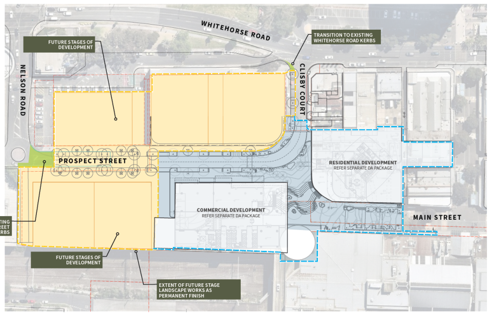
A
Figure 1:
Extent of Stage 1 works
The buildings and works (as described below) are
proposed on land currently occupied by a retail centre, and adjoining road and
pedestrian walkways. It involves a substantial area of privately owned land as
well as some existing road reserve that is owned by either Council or VicTrack.
Surrounds
The site is located centrally within the Box Hill
Metropolitan Activity Centre (MAC), providing access to a range of commercial,
retail and community facilities.
The Box Hill MAC has experienced significant growth
over the last decade, with the approval and construction of a number of
mixed-use developments in the order of 25-36 storeys at the core of the
activity centre and along Whitehorse Road.
The subject site is located within Built Form Precinct
F of the Box Hill Transit City Activity Centre Structure Plan, 2007,
allowing for taller buildings at increased densities.
The site maintains excellent access to public
transportation, owing to its proximity to the Box Hill Railway Station, Box
Hill Bus Interchange and the Tram Route 109 terminus. In addition to the
existing public transport network, the Suburban Rail Loop (SRL) has been
announced which proposes a new station within the Box Hill transport hub,
directly connecting the MAC to adjacent middle suburban regions and activity
centres. The proposed alignment of the SRL, as demonstrated within the
exhibited plans demonstrates that there is no physical impact on the subject
land. However, at present, no weight can be given to the environmental effects
statement as it is not a seriously entertained document.
The site maintains a direct connection to Market
Street and Main Street, being prominent civic spaces within the MAC, and
providing improved access to other services and community facilities within the
Activity Centre, including the education and hospital precinct to the
north-west.
REPORT FOR WH/2020/467 (PUBLIC REALM)
Planning Controls
Zone
The site is located within Clause 34.01 Commercial 1
Zone, the relevant purposes of which are:
· To implement the Municipal Planning Strategy and the
Planning Policy Framework.
· To create vibrant mixed use commercial centres for
retail, office, business, entertainment and community uses.
· To provide for residential uses at densities
complementary to the role and scale of the commercial centre
Pursuant to Clause 34.01-4, a planning permit is
required to construct a building or construct or carry out works.
Overlays
The site is located within Clause 45.09 Parking
Overlay (Schedule 1), which specifies car parking rates for dwelling and office
land uses, reduced from the statutory requirements prescribed under Clause
52.06-5 of the Planning Scheme. Any other use not listed under Clause 45.09
should accord with Column B of Table 1 of Clause 52.06-5.
As no land uses are proposed under this particular
application and no additional floor area is being created, the provisions of
Clause 45.09 or Clause 52.06 do not apply.
Particular Provisions
The particular provision of Clause 52.29 Land Adjacent
to the Principal Road network applies, the relevant purposes of which are:
· To ensure appropriate access to the Principal Road
Network or land planned to form part of the Principal Road Network.
· To ensure appropriate subdivision of land adjacent to
Principal Road Network or land planned to form part of the Principal Road
Network.
This clause applies to land adjacent to a road in the
Transport Zone 2, and a permit is required pursuant to Clause 52.29-2 to create
or alter access to a road in a Transport Zone 2.
As the proposal seeks to extend and alter Clisby
Court, a permit is required pursuant to Clause 52.29. Pursuant to Clause
52.29-4, an application must be referred under Section 55 of the Act to the
Department of Transport. This has been undertaken with their response reflected
below.
PROPOSAL
The proposal is for the construction and carrying out
of buildings and works on and adjoining the land at 17-21 Market Street, which
results in:
· The extension of the existing Clisby Court road
carriageway, with a new road connection into Prospect Street.
· The extension of the existing Main Street pedestrian
thoroughfare west through to Prospect Street, with a new east-west pedestrian
connection into Prospect Street.
The proposed buildings and works are demonstrated
within Figure 2 below, and involve an area in the order of approximately
4,725sqm. Whilst the land ownership across this area is mixed between Vicinity,
VicTrack and Council; the applicant has indicated that all buildings and works
are to be funded by the developer and permit applicant Vicinity Centres.
Key features of the proposed buildings and works are
nominated as follows
Main Street extension
· The addition of a new east-west pedestrian connection
(approx. 2,004sqm), extending from the western end of Main Street, and
connecting to the eastern end of Prospect Street.
· The central portion of the pedestrian thoroughfare,
located diagonally between the two buildings (under applications WH/2020/466
and WH/2020/597) features a tiered plaza connected by terraced staircases,
which are required as a result of the substantial level change between Main
Street and Prospect Street.
· Access between the lower and upper levels is also
proposed through a lift and escalator.
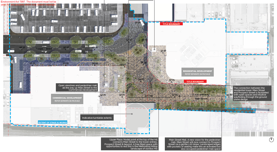
B
Figure 2:
Proposed buildings and works
Wind canopy structure
· The provision of a wind canopy structure, extending
over the urban plaza. Figure 3 below demonstrates the extent and design of the
canopy structure.
· The canopy structure has been architecturally
designed, with a mixture of high quality and permeable materials, with a
typical height of approximately 8 metres above the pedestrian thoroughfare.
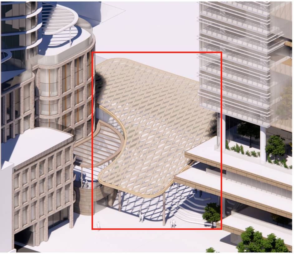
C
Figure 3:
Wind canopy structure on Main Street extension
Clisby Court extension
· The addition of a new section of road reserve
extending Clisby Court to the south, and connecting to Prospect Street which
currently terminates further to the west.
· At the junction of the road and pedestrian
thoroughfare, the application proposes a raised pedestrian crossing, to assist
with pedestrian movement across the road network.
Public realm treatments
· The upgrading of existing street and site
infrastructure, including footpaths, street furniture and landscaping
treatments.
Relocation of loading bay
· The relocation of the Box Hill Central South Shopping
Centre loading and unloading area from the western side of Main Street, to the
adjoining land to the south, and the enclosing of the pedestrian thoroughfare.
Temporary car park use
· The upgrade of the existing multi-deck shopping centre
car park facilities, to the direct abuttal of the railway line, continuing
their temporary use prior to future stages of development.
CONSULTATION
Public Notice and Consultation
The application was advertised by mail to the adjacent
and nearby property owners and occupiers. Following the advertising period six
(6) objections were received.
A Consultation Forum was held online via Zoom on 7th September 2021 chaired by Councillor
Liu. The forum was held for the broader Stage 1 redevelopment due to the
integrated nature of the works and the total objections received (a total of 40
objections received for Stage 1).
Objections
The issues raised are summarised as follows:
· Traffic congestion.
· Wind comfort.
· Limited open space.
· Response (or lack thereof) to Victorian Cycling
Strategy.
· Response (or lack thereof) to the north/south rail overpass.
· Closure of informal cycling network through Main
Street.
· Limitations on bicycle movement within the pedestrian
link.
A response to each issue is provided within the table below:
|
Objector concern
|
Planning Officer Response
|
|
Traffic congestion
|
This proposal does not result in any traffic
increase due to the nature of works. The applicant has submitted a
number of traffic impact assessments which demonstrate an acceptable traffic
response for the broader Stage 1 redevelopment, which have been further
considered under applications WH/2020/466 and WH/2020/597
|
|
Wind comfort
|
The applicant has submitted a number of
environmental wind assessments which demonstrate a variety of comfort
conditions commensurate to the use of the proposed thoroughfare. As such, the
proposal responds to the amenity outcomes sought within the policy at Clause
22.07
|
|
Limited open space
|
The proposal results in a substantial net increase
in areas for pedestrian activity and passive recreation through the creation
of a substantial urban plaza area. As such, the proposal provides sufficient
areas of open space and responds to the open space outcomes sought within the
policy at Clause 22.07
|
|
Lack of response to Victorian Cycling Strategy.
|
The proposal results in a substantially improved
east-west connection through the MAC which supports walking and cycling
opportunities. The proposal is not required to create connections to the
cycling network, beyond those nominated within the Structure Plan framework
(such as the north/south rail overpass). The applicant has committed to the
gifting of land along the western side of the allotment (Nelson Street
laneway) to ensure that any future north/south pedestrian and cycling
overpass can be accommodated. As such, the proposal responds to the broader
strategies pertaining to cycling
|
|
Lack of response to the north/south rail overpass
|
The applicant has committed to the gifting of land
along the western side of the allotment (Nelson Street laneway) to ensure
that any future north/south pedestrian and cycling overpass can be
accommodated. The feasibility report received by Council in relation to these
works confirms that the space being gifted is sufficient in dimension to
future proof this outcome
|
|
Closure of informal cycling network through Main Street
|
The closure of Main Street as part of the proposed
works is at the discretion of the landowner. This has been reviewed by
VicTrack with no further concerns raised.
Whilst this will temporarily limit east-west access
from the southern side of the rail line, there are other routes available
into the centre, until such time that the necessary overpass infrastructure
is provided.
|
|
Limitations on bicycle movement within the
pedestrian link
|
Due to the substantial topographical constraints of
the site, the proposal includes the provision of lifts, to support access
through the level change for those with limited mobility, or bicycle
movements. A ramp within the space would be an unacceptable urban
design outcome.
As noted above, the applicant has committed to the
gifting of land along the western side of the allotment (Nelson Street
laneway) to ensure that any future north/south pedestrian and cycling
overpass can be accommodated.
It is not solely the land owner’s
responsibility to solve bicycle issues within the MAC, rather it requires a
combination of land parcels and various government intervention to achieve a
successful long-term solution. The proposal seeks to contribute to and assist
with improvements to bicycle infrastructure within the immediate area.
|
Additional Submissions
A submission under Section 52 of the Planning and
Environment Act 1987 was received by Council from VicTrack on 28/08/2020,
who did not raise concern with the application subject to planning permit
conditions.
EXTERNAL AND INTERNAL REFERRALS
External
|
Referral Authority
|
Type
|
Response
|
|
Department of Transport
|
Section 55 (determining)
|
No objection, subject to planning permit conditions
|
Internal
|
Internal Department
|
Response
|
|
Transport
|
Concerns with the proposed traffic response. To be
discussed further below.
|
|
Asset
|
Concerns with the proposed engineering response. To
be discussed further below.
|
|
Design and Construct
|
A number of comments received in relation to the
design of the proposed buildings and works. These are addressed further
below, or via permit conditions.
|
|
City Works
|
A number of comments received in relation to the
design of the proposed buildings and works. These are addressed further
below, or via permit conditions.
|
|
Parks and Natural Environment
|
A number of comments received in relation to the
design of the proposed buildings and works. These are addressed further
below, or via permit conditions.
|
|
Strategic Planning and Landscaping
|
A number of comments received in relation to the
design of the proposed buildings and works. These are addressed further
below, or via permit conditions.
|
Other External Advice
Council has also referred the application material to both MGS
Architects and Vipac Engineers for independent advice on urban design and
environmental wind respectively. The table below summarises their response:
|
External Referral
|
Response
|
|
MGS Architects
|
Summary:
· Generally supportive of the proposed buildings and
works and public realm treatments subject to a number of recommendations,
specific to the other applications under Stage 1.
· These recommendations will be further discussed in
the associated application reports under WH/2020/466 and WH/2020/597.
|
|
Vipac Engineers
|
Summary:
· Vipac have reviewed the environmental wind
assessment and conclude that Mel Consultants (for the applicant) have used
the proper analysis and methodology to measure the wind effects on the
pedestrian level surrounding the proposed development.
· Where exceedances of the recommended wind criteria
have been found, appropriate recommendations have been made to mitigate and
improve wind comfort.
|
DISCUSSION
The proposed buildings and works, together with the
broader redevelopment of the site under Stage 1 will play a critical role in
Box Hill’s evolution as a vibrant and integrated centre that will allow
for the delivery of residential growth, within the MAC.
Specifically, the proposed buildings and works, would
substantially improve the east-west pedestrian connection through the MAC, as
well as facilitating a high-quality and accessible public realm for passive
recreation.
The assessment below will demonstrate that the
proposed buildings and works are an acceptable response for the site, as well
as the broader Stage 1 applications, and demonstrate a significant net community
benefit for the municipality.
Response to Policy Framework
The proposed buildings and works are consistent with
the policy framework outlined under the Whitehorse Planning Scheme.
Planning Policy Framework
The proposal responds to the relevant Victorian
policies applicable to the site.
The proposal responds to the objective of Clause
11.03-1S for Activity Centres by improving connectivity to retail, residential,
commercial and associated activity centre land uses within the MAC.
The proposal responds to the objective of Clause
15.01-1S for Urban Design by creating an enjoyable urban environment, that
supports safe access, improved pedestrian amenity and encourages walking and
cycling through the MAC.
The proposal responds to the objectives of Clause
15.01-4S Healthy Neighbourhoods by improving the east-west connection through
the MAC, and supporting walking, cycling and safe and convenient access between
precincts.
The proposal responds to the objectives of Clause
18.02-1S for Walking and 18.02-2S for Cycling by providing a new east-west
connection that provides improved access to various precincts and land uses
within the MAC, reducing reliance on the private vehicle. The applicant has
also committed to the gifting of land to the western side of the wider site to
future proof plans for pedestrian and cycling access across the railway line,
which is nominated as a key north-south link within Council’s strategic
framework for the MAC.
The proposal responds to the objective of Clause
18.02-3S for Public Transport by improving pedestrian access to and the uptake
of public transportation within the MAC.
The proposal responds to the objective of Clause
18.02-4S for Roads by facilitating a new road connection within the MAC that
continues to accommodate pedestrian movement.
Local Planning Policy Framework
The proposal responds to the relevant local policies
applicable to the site.
The proposal responds to the objectives of Clause
21.03 for A Vision for the City of Whitehorse by seeking to improve and enhance
the built environment and public open space within the Box Hill MAC.
The proposal responds to the objectives of Clause
21.05 for Environment through the provision of substantial canopy tree planting
and additional understorey soft landscaping opportunities within the pedestrian
connection and public realm offering and by encouraging the uptake of
sustainable transport through improved pedestrian connections and access to the
centres public transport interchanges.
The proposal responds to the objectives of Clause
22.07 for the Box Hill Metropolitan Activity Centre by substantially improving
precinct connectivity, including a new direct link between existing public
transport interchanges and the Prospect Street office precinct; encouraging and
supporting walking and pedestrian movement and the uptake of alternative
sustainable transport; and enhancing the provision of public space for social
interaction, passive recreation and community engagement.
Whilst Clause 22.15 for Public Open Space Contribution
identifies the site where a land contribution may be sought, the policy
indicates that land will be requested as accepted at Council’s
discretion, and this will be further considered within the subdivision. At
present, it is the view of planning officers that the proposed area of urban
plaza would not be suitable for land contribution due to the costs associated
with maintenance.
Pedestrian Amenity
The proposed buildings and works, together with the
necessary public realm treatments (street furniture, soft landscaping) will
ensure that the urban space is maintained with excellent pedestrian amenity.
Overshadowing
The policy at Clause 22.07, and under the header
‘Built Form’ seeks to protect ‘key open space’ from
overshadowing cast from new developments. The nominated ‘key open
space’ areas are identified within the Box Hill Transit City Activity
Centre Structure Plan 2007 (‘the Structure Plan’).
Within the Structure Plan, this policy outcome
is further reinforced through built form controls that seek to protect key open
space from overshadowing, between 11:00am and 2:00pm at the June solstice.
Whilst the proposal itself would not result in any
overshadowing impacts, the resultant works would create a highly accessible
east-west connection between Main Street and Prospect Street, functioning in
part as an urban plaza.
Furthermore, whilst the area of works proposed is not
identified as a ‘key open space’, the Structure Plan seeks to
enhance streets as public spaces, and beyond the substantial physical
improvements being made, maintaining solar amenity is critical in achieving
this objective.
As such, given that the proposal seeks to enhance the
public realm for the purposes of pedestrian connectivity and open space,
planning officers consider it appropriate to apply the same overshadowing
standards as nominated above for the purposes of this discussion.
The shadow diagrams prepared and submitted with this
application, demonstrate that the proposed pedestrian link and core area of
open space (nominated as ‘the Hill’ in the submissions) will
receive adequate solar amenity primarily between 12:00pm and 2:00pm at the
Solstice, with the land being overshadowed outside of these times by the
proposed buildings. The overshadowing will be further compounded by the Stage 2
works, which will need to be considered separately.
This is an acceptable response for the proposal,
particularly since there are no applicable overshadowing controls that apply to
this area of land within the policy or Structure Plan, and that the loss of solar
amenity between 11am and 12pm is offset by the substantial net benefit of the
additional east-west connection, and upgrading of public realm.
Further analysis of overshadowing impact as a result
of the proposed buildings under WH/2020/466 and WH/2020/597 will be discussed
separately.
Wind Comfort
The Environmental Wind Speeds Measures report prepared
by MEL Consultants (11/02/21) and subsequent addendum report prepared by MEL
Consultants (02/06/21) and submitted with this application demonstrates that
wind comfort within the proposed extent of works is generally acceptable for a
mix of walking, standing and sitting. Figure 4 below demonstrates the wind
comfort results within the extent of works:

D
Figure 4:
Wind comfort outcomes. Blue: Walking / Yellow: Standing / Green: Sitting
The image above demonstrates that under the proposed
configuration (which includes the proposed works under Stage 1 and other
approved projects):
· The extended length of Main Street into Prospect
Street achieves the walking comfort criteria (blue markers), which is suitable
for a pedestrian thoroughfare.
· The amphitheatre between Main and Prospect Street
(which includes an overhead wind canopy) achieves the sitting (green marker)
and standing (yellow marker) comfort criteria for short and long duration
stays. This is suitable for an urban plaza that also serves as an east-west
pedestrian thoroughfare, allowing for movement and passive recreation.
· The building entry into Lot 4 from Main Street meets
the standing comfort criteria (yellow marker), which is suitable for a building
entry.
· The building entry into Lot 5 from Main Street meets
the sitting comfort criteria (green market), which is suitable for a building
entry.
· The building entries into Lot 5 from Prospect Street
meets the standing comfort criteria (yellow market), which is suitable for
building entries.
The above results are all acceptable in their
locational context. Further analysis of wind impact as a result of the proposed
buildings under WH/2020/466 and WH/2020/597 will be discussed separately under
their respective applications.
Wind Canopy Structure
The proposed canopy structure (beyond its function for
wind mitigation), has also been considered on its architectural merit, ensuring
that it demonstrates an acceptable urban design outcome within the proposed
public realm.
The canopy is designed with a ‘weaved’
form, finished in a warm metal structured with masonry cladding to the columns.
The structure includes translucent roofing that would provide protection from
wind and rain, whilst retaining solar amenity into the thoroughfare and amphitheatre
at the mouth of Prospect Street.
The canopy has been designed to match the topography
of the land, improving both wayfinding opportunities, and a defined point of
entry along the length of the thoroughfare and between the level changes. The
height of the canopy at approximately 8 metres ensures that the structure
maintains a sense of openness, allowing for improved passive recreation and
landscaping outcomes. The design of the canopy structure has been resolved
through a series of meetings with Council’s Urban Designer, who has
accepted the design and intent.
The canopy maintains a contemporary and visually
interesting design that integrates with the detailing to the Stage 1 office and
residential buildings. The structure, on urban design grounds is supported.
Landscaping
The policy outcomes sought under Clause 22.07 seek to
improve and enhance the public realm, improve pedestrian access and promote
sustainable design and building works. This is further encouraged within
Section 4.8.F of the Structure Plan which states that designs should aim to
improve landscaping and consider increased use of indigenous vegetation, which
consume less water than many of the existing exotic species in the area.
The application material is supported by a Design
Report which demonstrates the landscaping and public realm treatments within
the area of buildings and works proposed, and includes a number of medium to
large canopy trees, medium to large shrubs, small shrubs and ground covers.
These are primarily of an indigenous and native variety and generally
consistent with the selected planting outcomes sought under the Box Hill Urban
Realm Treatment Guidelines. The species selection is supported.
The planting is proposed through the upper (Main
Street) and lower (Prospect Street) network, softening the extent of hard stand
on the site. Specifically, planting is proposed primarily to the edges of the
pedestrian accessway and to building entrances, improving pedestrian movement
and visibility through the site, whilst softening the extent of hard stand
proposed. Given that this space is identified as part of the priority
pedestrian network within the Structure Plan, the proposed location of
landscaping and canopy density is supported.
Further consideration will need to be given to planting
height and growth conditions for trees and shrubbery under the canopy
structure, which can be readily resolved through conditions for a detailed
landscape plan. This plan would also provide further details on the proposed
planter boxes, green walls and climbers, irrigation and maintenance.
Together with the public realm treatments (such as
seating, lighting, bins and the like), the proposed landscaping outcomes are
consistent with the policy outcomes under Clause 22.07, and will substantially
improve the landscaping along this proposed east-west connection and more
broadly within the Activity Centre.
Accessibility, Safety and Movement
The proposed east-west connection provides a new
pedestrian and bicycle link between Prospect Street and Main Street. This is a
crucial link through the MAC, connecting the public transport interchanges
directly with the office, health and education precincts as well as their
associated services and facilities within the centre.
These are identified as critical infrastructure works
which will substantially improve pedestrian and public realm amenity and
connectivity within the MAC, directly aligning with the relevant local policy
framework as well as the broader strategies under Clause 18.02-1S for Walking
which seeks to develop high amenity pedestrian networks for local areas that
link with the transport system and encourage a modal shift away from the
private vehicle.
The proposed buildings and works and pedestrian
connection includes two (2) lifts for both the residential and commercial
buildings as well as additional escalator services within the commercial
building, to improve access through the substantial level change, supporting
equitable movement through the site. Whilst these will be privately maintained
by the land owner, a condition of permit will require that these be accessible
to the public on a 24/7 basis, and maintained in working order at all times.
The proposed buildings and works and pedestrian
connection has been designed to integrate and interface with the proposed
residential and commercial buildings that have been lodged as part of the wider
Stage 1 redevelopment, improving passive surveillance and activation to the
streetscape.
The proposed buildings and works will transform the
currently underutilised areas of Clisby Court and Main Street (west), into an
enhanced public realm offering, improving site safety through improved
surveillance, activation and lighting. This is a substantial net benefit to the
MAC, with the broader policy framework recognising the importance of safe
public spaces.
Traffic, Loading and Unloading
Traffic
The proposed extension of Clisby Court to Prospect
Street connects the two existing no through roads, providing improved vehicular
circulation through the centre, and enabling access into the relevant buildings
under both Stage 1 and the future Stage 2.
The road extension is supported through the Transport
Impact Assessment (18/08/20) prepared by GTA Consultants, and subsequent advice
notes prepared by GTA Consultants (18/08/20 and 20/08/20) and submitted with
the application, which demonstrates that the proposed works would not result in
further detriment to the surrounding road network.
This is supported by the substantial net reduction of
parking as a result of the demolition works occurring to the Box Hill Central
North centre, and the reduced parking rates under the broader Stage 1 works.
The Transport Impact Assessment prepared by GTA Consultants indicates that the
existing provision of parking at Box Hill Central North generates approximately
565 vehicle movements in the PM peak hour and 800 movements in a Saturday peak
hour. At the completion of Stage 1 (including the commercial and residential
building), the total traffic generation would decrease across the critical peak
periods by -115 and -295 respectively.
Assuming a consistent parking provision (which was
adopted in the post-construction scenario by GTA Consultants), traffic
generation is then further decreased at the completion of the Stage 2 works, as
the additional land uses proposed will continue to generate less traffic than
the existing car parking structures on the site. It is expected that the
Saturday peak will decrease by approximately 75% due to the change in land use,
demonstrating a substantial shift away from the private vehicle, and improving
the traffic conditions from the existing land uses.
This is also further supported by SIDRA intersection
analysis which forms part of the Transport Impact Assessment prepared by GTA,
which indicates that there are currently moderate to high levels of existing
congestion within Box Hill, and whilst these are likely to marginally worsen
with continued development in the area, the modelling demonstrates that the
nearby intersection of Nelson Road / Whitehorse Road would still operate within
acceptable limits during the PM peak hour. Given the substantial reduction in
traffic generation across both Stage 1 and 2, the proposed road connection is
unlikely to result in any further intensification of the wider road network,
and this has been supported through the referral response received by the
Department of Transport.
The application material has also been considered by
the Department of Transport, who have not objected to the proposal subject to
permit conditions, with the following noted from their response:
Given this proposal is anticipated to intensify
movements (vehicular as well as pedestrian/cyclist movements) at the Clisby
Court/Whitehorse Road interface through its connection with Prospect Street and
the public plaza, the impact of this connection as it relates to its proximity
with the Fairbank Lane service road entry needs to be managed and mitigated
appropriately. The application documents currently do not specify any
mitigating works/measures to be implemented at the Clisby Court/Whitehorse Road
interface.
As such, the Department considers it appropriate to
include as conditions on permit requirements to investigate road safety risks
at this location through a Road Safety Audit and to ensure appropriate mitigation
is explored as it relates to all road users particularly pedestrians and
cyclists who may be attracted to travel through this area after the opening of
the public plaza between Prospect Street and Main Street.
These conditions will form part of any recommendation
made, and primarily relate to active transport movement and safety.
The proposed road connection has also been designed to
include a raised pedestrian north-south crossing to improve safe movement
across Prospect Street and into the east-west pedestrian thoroughfare, as well
as a number of visitor bicycle hoops to promote active transportation. A number
of short-term parking and loading spaces have been proposed to service the
future land uses through the broader stages of development.
Overall, the road connection is an acceptable response
for the site and can be recommended for support.
Loading and Unloading
The application seeks to enclose the proposed Main
Street thoroughfare, and relocate the existing loading and unloading further
south, abutting the Box Hill Central South shopping centre. The loading and
unloading area will be supported by a turntable system, allowing commercial
vehicles to enter and exit the site to and from Thurston Street in a forwards
direction.
Figure 5 below shows the location of the Main Street
closure and turntable.
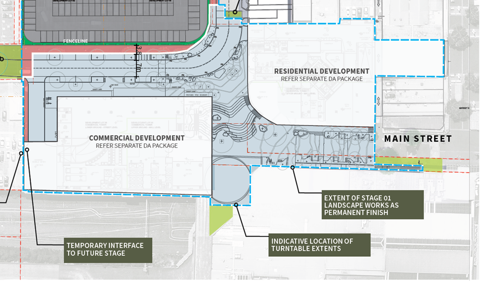
E
Figure 5:
Location of turntable and enclosure of Main Street
The relocation of these facilities and enclosure of
Main Street is supported as part of the substantial net benefit to the public
realm, and opportunity for a dedicated east-west pedestrian connection through
the Activity Centre. The turntable would provide an effective solution for
loading and unloading for Box Hill Central South. A condition will require that
this is maintained in good working order in perpetuity.
A number of sites to the south-western side of Market
Street also rely on the existing loading and unloading facilities on Main
Street, as access is provided to the rear of these properties through the rear
laneway, which can only be accessed from the Main Street end. The enclosure and
relocation of the loading and unloading facilities would be detrimental to
these sites. As such, to ensure that ongoing commercial access is facilitated,
a condition of permit will require the creation of an easement through the
length of laneway owned by Vicinity and accessed from Whitehorse Road. This
would be required through condition, prior to the enclosure of Main Street to
ensure no loss of commercial access.
Engineering Response
The application was referred to Council’s Asset,
Design and Construct and City Services departments, who have raised a number of
issues in relation to the proposed buildings and works, including but not
limited to:
· The ownership of the land;
· The cost of maintenance;
· Private structures under public roads;
· Civil engineering and design.
With regards to land ownership and cost of
maintenance, these matters will be settled through any future process for
subdivision of the land. This application has not considered any public open
space contribution, and this will be at Council’s discretion under Clause
22.15-3.
With regards to the location of basement under the
proposed Clisby Court road extension, these matters will be dealt with through
permit conditions for a Section 173 Agreement which seeks to protect Council
from any liability and ensure the works are appropriately engineered.
With regards to civil engineering and design, these
matters will be dealt with through conditions, requiring detailed civil /
drainage plans to demonstrate acceptable engineering, stormwater and flooding
outcomes. All to the satisfaction of Council.
CONCLUSION
The application has been considered against and
responds to the relevant objectives within the Planning and Local Planning
Policy Framework.
The proposed buildings and works will provide an
essential east-west connection through the Activity Centre, enabling
connectivity between the relevant precincts, but also encouraging the uptake of
walking and cycling as an alternative to the private vehicle.
The proposed buildings and works have also been
designed with a pedestrian focus, through the provision of improved
landscaping, public realm treatments, and appropriate wayfinding. The extent of
works will maintain acceptable amenity standards for movement and passive
recreation.
A total of six (6) objections were received as a
result of public notice and all of the issues raised have been discussed as
required. It is considered that the application should be approved, and a
Notice of Decision to Grant a Planning Permit be issued.
REPORT FOR WH/2020/466 (COMMERCIAL BUILDING)
Planning Controls
Zone
The site is located within Clause 34.01 Commercial 1
Zone. Pursuant to Clause 34.01-4, a planning permit is required to construct a
building or construct or carry out works.
Overlays
The site is located within Clause 45.09 Parking
Overlay (Schedule 1), which specifies car parking rates for dwelling and
offices land uses, reduced from the statutory requirements prescribed under
Clause 52.06-5 of the Planning Scheme. Where a car parking rate is not
specified, the rates outlined under Clause 52.06-5 of the Planning Scheme
apply.
The table below demonstrates the following statutory parking
requirements for the proposed building:
|
Description
|
Size
|
Statutory Rate
|
Parking Requirement
|
Parking Provision
|
|
Office
|
41,525sqm
|
2 spaces to each 100sqm NFA
|
830 spaces
|
202 spaces
|
|
Food and drink premises
|
1,318
|
3.5 spaces to each 100sqm of LFA
|
46 spaces
|
0 spaces
|
|
Total
|
876 spaces
|
202 spaces
|
A total of 202 car parking spaces is proposed and a
planning permit is required to reduce the car parking requirements by 674
spaces.
PROPOSAL
The proposal is for the construction of a part 27 and
part 28 storey building at 17-21 Market Street, comprising of office and retail
floor space. The building is positioned to the western edge of Main Street and
the southern side of Prospect Street.
The key features of the proposed building are as
follows:
· The provision of 42,843sqm of office floor space
within the podium and tower levels.
· The provision of 1,317sqm of retail floor space at
both the lower and upper ground levels within the podium.
· The provision of 202 car parking spaces located within
four (4) levels of basement.
· The provision of 408 bicycle parking spaces and
associated end-of-trip-facilities within the lower ground level and lower
ground mezzanine.
Key features of the proposed buildings and works are
nominated as follows:
Podium
The application includes a three storey podium that
interfaces with Prospect Street on the lower ground level and Main Street on
the upper ground level.
At the lower ground level, the podium includes a
number of retail premises interfacing with the Prospect Street as well elevator
access to the upper level of Main Street. Vehicular access is located to the
western side of the building via a proposed laneway leading into the basement
levels and back of house areas.
At the upper ground level, the podium includes the
primary building entry from the western side of Main Street which provides lift
access to the office levels above. The upper level also includes a number of
retail and commercial tenancies that are accessed from the street or internal
to the building.
The upper levels of the podium are all accessible via
the lift core, and include a series of office tenancies, tenant amenities and
plant and services. The buildings podium has been designed to integrate in with
the proposed buildings and works proposed under WH/2020/467, which provide
improved pedestrian connectivity, landscaping and public realm works.
Tower
Above the podium levels, the application proposes an
upper level tower, with a total height of 27 storeys from Main Street (maximum
height of 108.85 metres) and 28 storeys from Prospect Street (maximum height of
115 metres).
The tower maintains a generally consistent massing
through its height with consistent side and rear setbacks. The tower
incorporates recessed balcony / tenancy zones spanning the length of the
building. Each floor plate is accessed via the lift core and used for the
purposes of office and inclusive of tenant amenities.
Figure 2 below demonstrates a mid-level indentation to
the west, away from the Main Street termination. The upper levels of the tower
continue to align with the lower ground podium forms. At the upper level, the
footprint is further eroded with north-western terraces and a recessed upper
level footprint. The roof levels include a number of building services and
equipment which would be screened by vertical metal louvres.
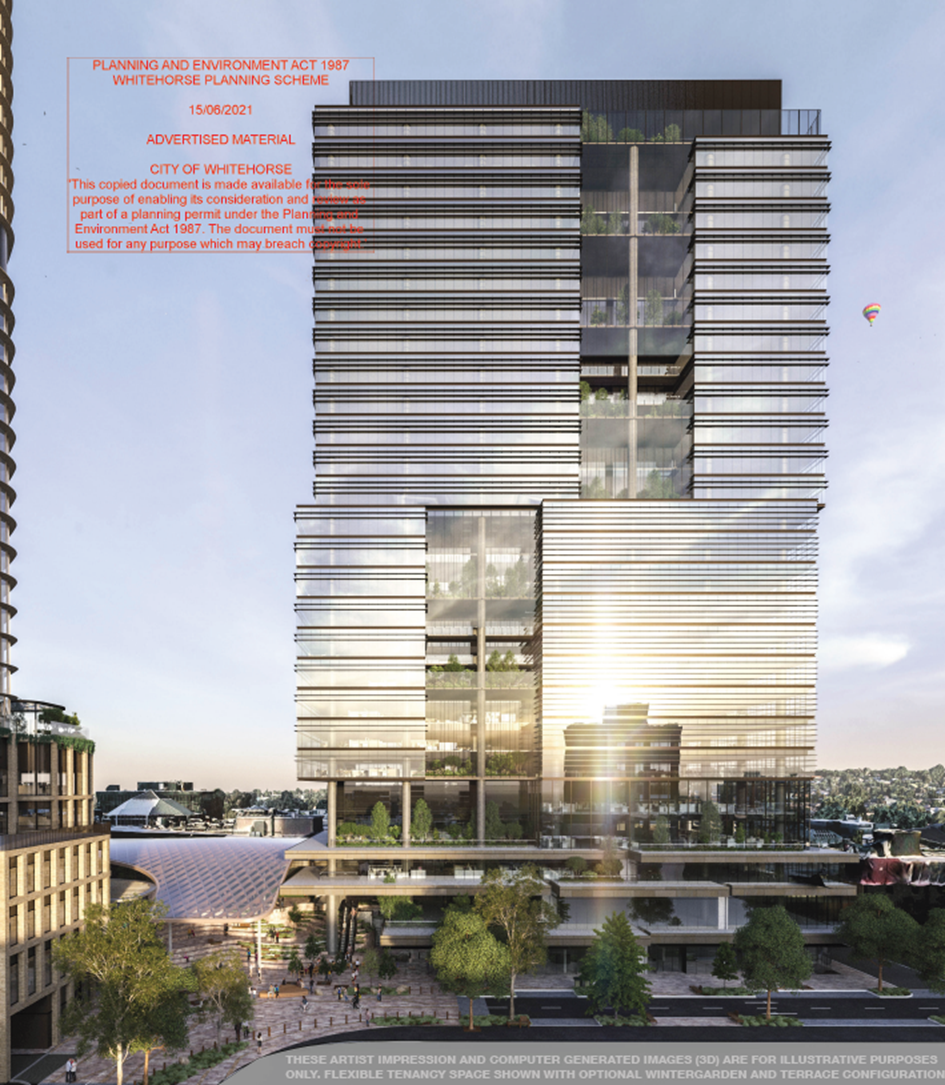
F
Figure 6:
Commercial Building Full Height
Design Detail and Materials
The podium and tower is primarily clad with a glazed
curtain wall, with protruding horizontal masonry and metal bandings as depicted
in Figure 2 above.
Vehicle Access, Parking and Loading
A total of 202 car parking spaces would be provided
for employee use within four (4) levels of basement. The basement is accessible
via a new laneway proposed to the western side of the building that intersects
with Prospect Street. The car parking spaces are proposed to be managed by an
external operator, with underutilised spaces made available to the general
public.
Two (2) on-site commercial vehicle bays are proposed
to the rear of the building at the lower ground level, providing access for
loading and unloading and waste collection.
A total of 398 bicycle parking spaces are provided
within the lower ground end-of-trip facilities, accessible from Prospect
Street. An additional ten (10) spaces provided for public use on Prospect
Street, beyond the site’s boundaries.
End-of-trip facilities include 39 showers, male and
female communal change rooms and access to 389 lockers for bicycle users and
are accessible from the lower ground level, with lift access to the lower
ground mezzanine.
CONSULTATION
Public Notice and Consultation
The application was advertised by mail to the adjacent
and nearby property owners and occupiers. Following the advertising period nine
(9) objections were received.
A Consultation Forum was held on 07 September 2021 chaired by Councillor Liu. The forum
was held for the broader Stage 1 redevelopment due to the integrated nature of
the works and the total objections received (a total of 40 objections received
for Stage 1).
Objections
The issues raised are summarised as follows:
· Overdevelopment.
· Bulk and massing.
· Traffic congestion.
· Wind comfort.
· Reflectivity.
· Limited open space.
· Construction impacts.
A response to each issue is provided within the table below:
|
Objector concern
|
Planning Officer Response
|
|
Overdevelopment
|
The subject site is located within the Major
Development Precinct F, anticipating substantial intensification of the land.
The proposed building responds to its policy setting.
|
|
Bulk and massing
|
The subject site is located within the Major
Development Precinct F, anticipating substantial intensification of the land.
The building has been designed in accordance with
the relevant built form guidelines of the Structure Plan and provides a level
of detail and architectural merit to eliminate bulk and massing.
The design response has also been considered by an
independent urban design expert who generally supports the proposed built
form. The proposal is therefore acceptable against the relevant built form
outcomes.
|
|
Traffic congestion
|
The post-construction outcomes under Stage 1
demonstrate a reduced number of car parking spaces when compared to the
existing buildings on the land, resulting in reduced traffic generation from
the site.
The reduced rate of car parking seeks to limit
demand into the centre and achieve a significant modal shift away from the
private vehicle.
The proposal is therefore considered to meet the
relevant policy outcomes sought for land use and car parking.
|
|
Wind comfort
|
The applicant has submitted a number of
environmental wind assessments which demonstrate a variety of comfort
conditions that would be acceptable for the building’s entries and
adjoining pedestrian footpath.
|
|
Objector concern
|
Planning Officer Response
|
|
Reflectivity
|
The applicant has submitted a desktop reflectivity
assessment, which demonstrates that glint and glare impacts will be managed
through the design detail phase of construction.
A condition of permit will require a reflectivity
assessment to demonstrate that the proposal will not result in unreasonable
glint and glare to any sensitive receptors.
|
|
Limited open space
|
There is no requirement for office buildings to
provide communal open space. Nonetheless, the building proposes communal
terraces for office tenancies, improving employee amenity.
In addition, the proposal is designed to integrate
in with the public realm improvement works made under WH/2020/467 which will
provide additional areas of urban open space.
|
|
Construction impacts
|
A permit condition will recommend a construction
management plan which will seek to manage any offsite construction impacts
during the construction period.
|
Additional Submissions
A submission under Section 52 of the Planning and
Environment Act 1987 was received by Council from VicTrack on 28/08/2020,
who did not raise concern with the application subject to planning permit
conditions.
EXTERNAL
AND INTERNAL REFERRALS
External
|
Referral
Authority
|
Type
|
Response
|
|
Department of Transport
|
Section 55 (determining)
|
No objection, subject to planning permit conditions
|
Internal
|
Internal Department
|
Response
|
|
Transport
|
Concerns with the proposed traffic response and
basement layout. To be discussed further below.
|
|
Assets
|
Concerns with the proposed engineering response,
subject to permit conditions. To be discussed further below.
|
|
Design and Construct
|
A number of comments received in relation to the
broader public renewal works. These have primarily been addressed under
WH/2020/467.
|
|
Internal Department
|
Response
|
|
City Works
|
A number of comments received in relation to the
broader public renewal works. These have primarily been addressed under
WH/2020/467.
|
|
Parks and Natural Environment
|
A number of comments received in relation to the
broader public renewal works. These have primarily been addressed under
WH/2020/467.
|
|
Strategic and Landscaping
|
A number of comments received in relation to the
design of the proposed buildings and works. These are addressed further
below, or via permit conditions.
|
|
ESD
|
ESD expectations met, subject to permit conditions
|
|
Waste
|
Concerns with waste generation / bin requirements,
to be further confirmed once tenancies are finalised
|
Other
External Advice
Council has also referred the application material
externally to both MGS Architects and Vipac Engineers for independent advice on
urban design and environmental wind respectively.
The table below summarises their response:
|
External Referral
|
Response
|
|
MGS Architects
|
Summary:
With modest refinements as proposed in
Recommendations 1 to 3 I am satisfied that in urban design terms the proposed
commercial building is acceptable delivering a well specified, thoughtfully
configured and contextually responsive workspace building with appropriate
supporting and activation retail street levels and interconnections that
deliver much needed interconnection between the western Prospect Street
Commercial Street and Northern Health and education Precincts and the retail
and Public transport core.
The recommendations made by MGS will be discussed
further below.
|
|
External Referral
|
Response
|
|
Vipac Engineers
|
Summary:
· Vipac have reviewed the environmental wind
assessment and conclude that Mel Consultants have used the proper analysis
and methodology to measure the wind effects on the pedestrian level
surrounding the proposed development.
· Where exceedances of the recommended wind criteria
have been found, appropriate recommendations have been made to mitigate and
improve wind comfort.
|
DISCUSSION
The proposed building, together with the broader
redevelopment of the site under Stage 1 will play a critical role in Box
Hill’s evolution as a vibrant and integrated centre that will allow for
the delivery of employment growth within the Metropolitan Activity Centre (MAC)
as envisaged under Clause 22.07.
Specifically, the proposed building will result in a
substantial net increase of approximately 43,000sqm of office floor space,
facilitating employment growth and supporting the commercial viability of the
MAC. The proposed building represents an architectural outcome that is
consistent with the built form outcomes of the relevant policy and Box Hill
Transit City Activity Centre Structure Plan 2007 (“the Structure
Plan”), and seeks to enhance the built environment and immediate public
realm, in association with the broader works and landscaping outcomes proposed
under Stage 1.
The assessment below demonstrates that the proposed
buildings and works provide both an acceptable design response for the site, as
well as the broader Stage 1 applications, and demonstrate a significant net
community benefit for the municipality, generally in line with the policy
direction under the Whitehorse Planning Scheme.
Policy Framework
Planning Policy Framework (PPF)
The proposal responds to the objective of Clause
11.03-1S for Activity Centres which seeks to encourage the concentration of
various land uses into highly accessible activity centres through a substantial
net increase in office and retail floor space, supporting the role and function
of the MAC.
The proposal responds to the objective of Clause
15.01-1S for Urban Design and Clause 15.01-2S for Building Design through a
site responsive design that positively contributes to and enhances the built
form and public realm character of the Box Hill MAC.
The proposal responds to the objective of Clause
15.02-1S Energy and Resource Efficiency by formally registering to achieve a
‘5 Star Green Star Design’ and ‘As Built rating’,
conforming to Council’s ESD expectations under Clause 22.10.
The proposal responds to the objectives of Clause
15.01-4S Healthy Neighbourhoods by proposing a development that contributes
excellent connection opportunities to the nearby walking, cycling and public
transit routes, promoting opportunity for regular and healthy activity to and
from the site by encourage the uptake of alternative and sustainable
transportation.
The proposal responds to the objectives of Clause
17.01-1S for Diversified Economy and Clause 17.02-1S for Business by supporting
employment growth and access to jobs within the MAC through the provision of
approximately 43,000sqm of office floor space and 1,400sqm of retail floor
space.
The proposal responds to the objectives of Clause
18.02-1S for Walking and 18.02-2S for Cycling by supporting the uptake of these
modes of transport through a substantial increase in bicycle parking that is
easily accessible from the primary pedestrian network with excellent amenities
for staff and visitors.
The proposal responds to the objective of Clause
18.02-3S for Public Transport by substantially reducing the reliance on the
private vehicle and supporting the uptake of the multitude of nearby public
transport options.
Local Planning Policy Framework (LPPF)
The proposal responds to the vision for Whitehorse
outlined under Clause 21.03 for A Vision for the City of Whitehorse
which seeks to maintain and enhance the built environment to ensure a liveable
and sustainable city by seeking to substantially improve the built environment
within the Box Hill MAC and providing a substantial net increase in office
floor space that supports the local economy.
The proposal responds to the objectives of Clause
21.05 for Environment through the development of an environmentally
sustainable building (5 Star Green Star Rating) and by encouraging the uptake
of sustainable transportation through reduced on-site car parking, enhanced
bicycle facilities and improved connections that substantially improve direct
pedestrian access to the Box Hill public transport interchange.
The proposal responds to the objectives of Clause
21.07 for Economic Development by facilitating a substantial investment in high
quality office space within the MAC, housed within a contemporary and
attractive built environment.
The subject site is located within the ‘Prospect
Street’ activity precinct and the ‘Major Development’ built
form precinct which together seek to support taller buildings primarily for
office and employment purposes. The proposal responds to the objectives of
Clause 22.07 for the Box Hill Metropolitan Activity Centre through the
provision of approximately 43,000sqm of additional office floor space,
facilitating employment growth and access and strengthening the role of the MAC
as a major commercial hub. In addition, the proposed building has been designed
to respond to its immediate surrounds, with substantial improvements to the
built and the pedestrian environments.
The proposed development also seeks to enhance the
pedestrian experience of Box Hill with activate frontages, and together with
the broader public realm works will seek to make substantial public realm
improvements to the Box Hill MAC, consistent with the policy objectives of
Clause 22.07.
Urban Design
Urban Design Advice
Council have received independent urban design advice from MGS
Architects for the proposed building, which offers a number of key
recommendations seeking to improve the urban design outcomes of the building.
These are outlined in the table below, with planning officer responses:
|
Urban Designer Recommendation
|
Planning Officer Response
|
|
Recommendation 1:
Provide wind speed mitigation measures including
through landscape measures and balustrade heights to ensure that
the areas 33 a to 33 d described above achieve a wind speed comfort
level for sitting to support their underlying role within the project and
centre and the objectives in local and state policy and the proposed
Structure Plan and UDF.
|
The applicant has responded to this recommendation
through the application process having provided revised wind assessment
reports which demonstrate acceptable wind comfort levels in the identified
areas.
This is discussed further below under
‘amenity’.
|
|
Urban Designer Recommendation
|
Planning Officer Response
|
|
Recommendation 2:
Provide landscaping treatments and an updated
Landscape plan showing revised tree planting and understorey planting and
screening measures as proposed in the Wind Consultant report to include the
planting of mature tree planting as follows:
· Close spaced large evergreen trees (8m high x 6m
wide dense [70% solidity] canopies) and under planting up to the underside of
the tree canopies and;
· Wind break screens, to the satisfaction of the
responsible authority or alternatively invest the façade with
additional articulation and setbacks to reduce the impacts arising from the
proposal to achieve similar outcomes.
|
The applicant has indirectly responded to this
recommendation through revised wind assessment reports which demonstrate
acceptable wind comfort levels in the identified areas.
This is discussed further below under ‘amenity’.
It is noted that in improving wind comfort, additional landscaping has not
been required.
|
|
Recommendation 3:
Modify the scale and setbacks of the proposed plant
areas and upper floors at the western end of the tower to ensure the western
footpath of Thurston Street is not overshadowed at 11am at the September 22nd
Equinox to the satisfaction of the Council
|
The applicant has responded to this recommendation
through an updated overshadowing analysis which demonstrates that the western
footpath of Thurston Street is not overshadowed at 11am on the September 22nd
equinox.
This is discussed further below under the building
height header.
|
No further recommendations were made, with
Council’s urban designer finding that the proposed building height and
massing were responsive to the site and surrounds.
Building Height and Overshadowing
Building heights within the Box Hill MAC are primarily
guided by two urban design principles established within the Structure Plan
(2007), namely that built form appropriately transitions to the surrounding
residential areas at the edges of the Activity Centre, and that new development
does not cast shadows to Key Public Spaces, peripheral Residential Precincts or
residential areas outside the Activity Centre between 11am and 2pm on 22 June.
In addition to the above, the Structure Plan also
seeks to maintain and improve pedestrian amenity and enhance streets as public
spaces to support and cultivate a range of activity. This is further supported
within the built form guidelines of the Major Development Precinct under Clause
5.2.F which identifies the need to protect the amenity (including access to
sunlight) of streetscapes.
In assessing the appropriateness of the proposed
building height, planning officers refer to the decision guidelines of the
Zone, and the objectives of the Policy Framework and Structure Plan.
Building Height
In determining that the proposed 27-28 storey building
height is an acceptable response to the precinct’s vision and built form
characteristics, it is first important to understand the context of the site
and surrounding area. The following developments have been constructed or
approved in the immediately surrounding area and are deemed relevant to the
context of the subject land:
· 9-11 Prospect Street: 25 storeys (under construction)
· 22-24 Prospect Street: 25 storeys (approved)
· 25-29 Prospect Street: 23 storeys (approved)
· 26-28 Prospect Street: 30 storeys (approved)
· 31-35 Prospect Street: 23 storeys (approved)
· 34-36 Prospect Street: 30 storeys (approved)
The above developments demonstrate the emerging height
characteristics along the east-west alignment of Prospect Street, all of which
are located within major development precinct F (permitting taller building).
These approvals / developments have also been designed in a manner that seeks
transition to the residential periphery beyond the railway corridor
particularly from the taller Whitehorse Road built form to the north, either
through a raking of form, or a reduced building height when compared against
the buildings on Whitehorse Road.
The subject site shares similar locational
characteristics to the above developments listed, being:
· Located within built form precinct F, which supports
taller buildings;
· Positioned to the northern side of the railway
corridor and on the same east-west alignment; and
· Maintains an interface to the residential periphery to
the south-east.
These locational characteristics, together with the
policy applicable to the site establish a clear expectation for intensification
on the land, which would support the proposed height of the building at 27-28
storeys.
The proposed construction of a 27-28 storey building
is consistent in the context of Prospect Street, respecting the existing and
emerging height characteristics to the west.
Overshadowing
As noted above, building heights along Prospect Street
have partially been derived/limited as a result of the impact of overshadowing
to the adjoining residential areas south of Hopetoun Parade.
The current policy objectives within the Whitehorse
Planning Scheme that are specific to overshadowing are as follows:
· Built form policy at Clause 22.07 (Box Hill
Metropolitan Activity Centre) encourages development that protects key open
spaces from overshadowing.
· 5.2.F of the Structure Plan for the Major Development
Precinct encourages development to avoid overshadowing of Key Public
Spaces, Peripheral Residential Precincts or residential areas outside the
Activity Centre between 11am and 2pm on 22 June, beyond what would result from
an 11m building over the full extent of the site
· 5.2.F of the Structure Plan for the Major Development
Precinct seeks to protect the amenity (including access to sunlight) of
streetscapes and Key Public Spaces.
Whilst the Structure Plan does not include an
overshadowing test for the pedestrian network within the MAC, adopting 11am to
2pm at the Equinox is considered to be a balanced assessment approach that is
consistent with a number of Council approved permits on Prospect Street and
further supported by Council’s urban design advice received on the
application.
The table below outlines the relevant areas for protection and the
associated overshadowing tests:
|
Location
|
Overshadowing test
|
Response
|
|
Market Street and Main Street (east) civic plaza
(Key public space within the Structure Plan,
2007)
|
June solstice, 11am to 2pm
|
No shadow impact from the building to Market Street
or Main Street east between 11am and 2pm at the Solstice
|
|
Carrington Road
(Key public space within the Structure Plan,
2007)
|
June Solstice, 11am to 2pm
|
No additional shadow impact from the residential
building to Carrington Road between 11am and 2pm at the equinox, beyond what
would result from an 11m building over the full extent of the Box Hill
Central South site
|
|
Location
|
Overshadowing test
|
Response
|
|
Hopetoun Parade pedestrian footpath (southern side)
|
September equinox, 11am to 2pm
|
No shadow impact from the building to the southern
side of the Hopetoun Parade footpath between 11am and 2pm at the Equinox
|
|
Thurston Street pedestrian footpath (western side)
|
September equinox, 11am to 2pm
|
No shadow impact from the building to the western
side of the Thurston Street footpath between 11am and 2pm at the Equinox
|
|
Residential periphery private property (southern
side of Hopetoun Parade / western side of Thurston Street)
|
September equinox, 11am to 2pm
|
No shadow impact from the building to residential
periphery between 11am and 2pm at the Equinox
|
The
table above demonstrates that the height of the proposed building would not
result in any overshadowing impact to these spaces between 11am and 2pm at
either the Winter Solstice or September Equinox. Where the proposed building
results in shadowing to the Carrington Road ‘Key Public
Space’ between 11am and 2pm at the Winter Solstice, the shadow diagrams
demonstrate that this space would already be overshadowed by an 11 metre
building over the full extent of the site (meeting the guidance under the
Structure Plan).
The
proposed building has been designed to respond to the immediate context, with
the building height not resulting in any unacceptable overshadowing impact to
the existing public realm). This is consistent with the relevant policy
objectives and outcomes applicable to the site, and demonstrates an outcome
that continues to maintain the solar amenity of the surrounding public open
spaces and priority pedestrian network, supported by the policy outcomes under
Clause 22.07 as well as the guidelines of the Structure Plan (2007).
In
addition to the above, the height of the proposed building at 27-28 storeys (as
described above) is consistent with the immediate surrounds, noting a number of
approvals and recently completed developments on Prospect Street, which would
also result in similar shadow outcomes between 9am and 10am at the Winter
Solstice. Planning officers utilised a consistent approach in determining
building height for those Prospect Street applications, using the September
Equinox as the primary test between 11am and 2pm, and not accepting
overshadowing to the southern side of Hopetoun Parade pedestrian footpath.
The expectation of amenity for dwellings within the
residential periphery must be balanced with the increased density being
achieved and anticipated within the MAC consistent with the strategic direction
for the land. In this instance, the areas of private open space that are likely
to be overshadowed will still receive solar amenity during the day beyond 9am
or 10am and the extent of shadowing from the building to the residential
periphery is acceptable when balanced against the strategic intent for the site
and the excellent built form outcomes for the Box Hill MAC.
Built Form
The proposed building design is responsive to the
built form objectives of the Major Development Precinct outlined within the
Structure Plan, and supported by the relevant objectives of Clause 22.07 for
the Box Hill Metropolitan Activity Centre.
The built form outcomes sought for development under
Clause 22.07 and the Precinct F built form guidelines of the Structure Plan are
summarised as follows:
· Articulated building facades and high quality building
materials, demonstrating design excellence and visually interesting built form.
· Podium-tower building formats, with upper levels
recessed to provide ample spacing between high-rise buildings.
· Active street level frontages to enhance the public
realm at ground levels and improve pedestrian permeability.
· Active land uses within the podium to support
opportunities for passive surveillance.
The
following sections of the report will assess the buildings form and
architectural arrangements of the building.
Building Setbacks
The built form guidelines of Precinct F encourage
upper level building (tower) setbacks above 12 metres (from Main Street) and 16
metres (from other streets), and seeks to ensure that setbacks between
buildings are sufficient to allow equitable development outcomes.
The building proposes the following upper level
setbacks above the podium at each interface:
· North (front): tower setbacks between 3.175m and
5.775m
· East: tower setbacks between 1m and 3.4m
· South (rear): tower setbacks between 1.005m and 3.185m
· West: tower setbacks between 0m, 14.88m and 16.68m
The proposed upper level setbacks accord with the
built form guidelines of Precinct F. In addition, the proposed setbacks are
generally consistent with those adopted in recent approvals, including a number
on the east-west alignment of Prospect Street which typically adopt setbacks of
4.5 metres through the tower form. This demonstrates that the proposed building
has been designed to maintain consistency with the emerging built form and
massing outcomes within the MAC and specifically buildings within Major
Development Precinct F.
Furthermore, the proposed setbacks of 14.88m and
16.68m to the future Lot 6, would allow for equitable development opportunities
for any Stage 2 buildings, including access to daylight and an appropriate
outlook.
The proposed building’s massing is therefore
acceptable in its context, respecting the existing and emerging built form
outcomes in the immediate area, and responding to the policy outcomes sought
under the Major Development Precinct F.
Architectural Expression
The proposed development adopts a highly refined
design that presents as visually interesting when experienced in the pedestrian
realm and from afar. This responds to the policy objectives of Clause 22.07
which encourages design excellence.
The podium levels feature a layered design response
with overlapping horizontal bands that articulate the building form, and
provide a distinct building base, separate to the tower above. The layered
design allows for improved landscape opportunities, and incorporates
substantial clear glazing for streetscape activation and passive surveillance
opportunities. The podium adopts a number of vertical concrete elements spaced
evenly along its length to maintain a finer grain streetscape rhythm that is
consistent with the broader Box Hill built form, but also to break down the
continuous extent of form and improve the pedestrian experience. This is
supported by Council’s urban design advice.
At the upper levels, the tower adopts a more
formalised appearance through the use of glazed curtain wall and horizontal
metal bandings that span across each level. The tower form shifts from east to
west at level 12, providing substantial articulation and visual interest to the
overall building form. The tower adopts a central tenancy zone, in the form of
either a balcony or void that further breaks down the width of the building
through a clear central recession. The tower includes an upper level services
screen with vertical louvres which serves as a building cap. This is supported
by Council’s urban design advice.
The proposed design response is well considered,
demonstrating architectural excellence that is consistent with the built form
policy outcomes sought under Clause 22.07. Planning officers have recommended a
condition that requires the permit holder to retain the project architect (or
architect of equivalent experience), to ensure that the design quality is
maintained throughout the design and construction process.
Public Realm
The majority of the public realm improvements
associated with the Stage 1 redevelopment are the subject of Planning Permit
Application WH/2020/467 (for the public works) and have been designed to
integrate in with and compliment the proposed building.
The public realm works would provide a new pedestrian
connection between Main Street through to Prospect Street and Clisby Court,
substantially improving pedestrian movement and permeability and provide
greater opportunity for passive recreation.
The western end of Main Street currently terminates at
a loading bay associated with the Woolworths Supermarket, and has limited foot
traffic due to the back of house function of this interface. The proposed
public realm works associated with this building would activate the currently
underutilised area at the western end of Main Street, providing activated
tenancies oriented to both Main Street and extending down to Prospect Street,
resulting in significant amenity improvements. This further supports the
east-west connection proposed under WH/2020/467, providing high-amenity
pedestrian access between the public transport interchanges directly to the
Prospect Street office precinct.
The proposed podium also includes an extended canopy, providing shelter
from rain and wind, and providing a transitional forecourt space between the
building entrance, Main Street and Prospect Street on the lower ground level.
The proposed tenancies adopt high levels of clear glazing to provide a visual
connection to the streetscape and provide opportunity for passive surveillance
which is currently lacking under the existing conditions. Figures 3 and 4 below
demonstrate the existing Main Street interface and compares it to the proposed
outcomes and compares it to the proposed public realm outcomes.
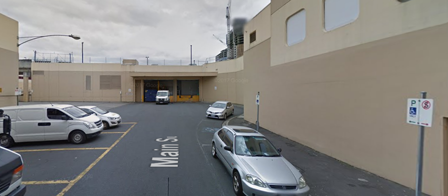
G
Figure 7:
Existing Main Street west interface
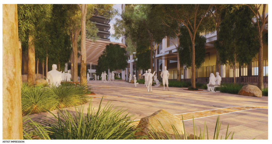
H
Figure 8:
Proposed Main Street west interface
Pedestrian Amenity
The proposal seeks to enhance the pedestrian environment
through substantive public realm improvements associated with the Stage 1
redevelopment of the site. These have been discussed above.
As part of these improvements, the proposal ensures
that the pedestrian environment maintains high levels of amenity by way of
sunlight, wind comfort (discussed below) and high levels of clear glazing to
provide visual connection and surveillance into the street.
The proposed public realm also makes substantial
visual improvements to what is currently a back of house area and car park to
the western end of Main Street and eastern end of Prospect Street through the
use of high quality materials, increased landscaping opportunities and improved
street furniture that seeks to enhance the space for improved passive recreation
and to serve as a genuine urban plaza.
Overall, the proposed areas of public realm maintain
excellent amenity for the pedestrian environment, enhancing the space for its
enjoyment and use.
Wind Comfort
The Environmental Wind Speed Assessment prepared by
MEL Consultants demonstrates acceptable wind outcomes for the building’s
entry, lower ground pedestrian footpath and upper level terraces.
The upper ground building entry and surrounding
transitional space on Main Street (test locations 16 and 16a under Figure 7b of
the Environmental Wind Speed Assessment) demonstrates sitting comfort. This
exceeds the expected wind comfort criteria for building entries, in which
standing comfort would be typically sought.
The lower ground pedestrian footpath (and retail
interface) to the northern side of the building, including the access to the
lower ground escalators at test locations 16b and 55 demonstrates standing
comfort. This meets the expected wind comfort criteria for building entries,
and would allow for safe and comfortable access onto the escalator as a
transitory space between lower and upper ground floors.
The upper level (level 2) terraces to the
north-eastern side of the building at test locations P5 and P6 demonstrate
standing (west) and sitting (east) comfort. This meets the expected comfort
criteria for communal terraces in a non-residential setting and would provide
acceptable comfort for short-term passive recreation (suitable for terrace
space associated with an office building).
The ground level, north-western side, at the corner of
Prospect Street and the proposed side road for vehicular access at test
locations 57, 59a and 63a demonstrate walking comfort. This is suitable for the
pedestrian footpath.
The remaining test locations either remain unchanged
(from the existing wind conditions) as a result of the development, or result
in reductions that would be acceptable in their locational context (i.e.
footpath, other building entries). These can be further addressed and
considered within Stage 2 that would require further mitigation mechanisms.
As such, the proposed wind outcomes resulting from the
building are acceptable.
Landscaping
Landscaping external to the building envelope and
within the immediate surrounds has been further considered and assessed under
Planning Application WH/2020/467 for the public realm works. It is noted that
within this assessment, the landscaping outcomes within the proposed public
realm (urban plaza and street/road extensions) are generous and result in a net
increase in canopy density and soft landscaping, consistent with the policy
expectations under Clause 21.05 for Environment.
Traffic, Car and Bicycle Parking and Loading and
Unloading
Car Parking
The table below demonstrates the following statutory car parking rates
for the building:
|
Description
|
Size
|
Statutory Rate
|
Parking Requirement
|
|
Office
|
41,525sqm
|
2 spaces to each 100sqm NFA
|
830 spaces
|
|
Retail (food and drink premises)
|
1,318
|
3.5 spaces to each 100sqm of LFA
|
46 spaces
|
|
Total
|
876 spaces
|
A total of 202 car parking spaces are provided, and
therefore a reduction of 674 car parking spaces is sought. This equates to a
rate of 0.48 spaces per 100sqm for offices and 0 spaces for the retail (food
and drink) premises.
Council’s Transport Engineering team
acknowledges the strategic intent to provide less parking on the site, but
suggests that the reduction is too substantial without further specific justification.
Through the application process, Planning Officers
however have reviewed the traffic analysis as well as the broader policy
framework for the site and wider MAC, and consider the reduction to be
acceptable for the land use. This is based primarily on the following factors:
· The policy framework for parking within the Box Hill
Metropolitan Activity Centre.
· The use of the land for retail and office and the type
of demand generated;
· The opportunity to improve and increase pedestrian and
alternative modes of transportation through the provision of the Main Street
extension through to Prospect Street and the availability of land for future
bicycle connectivity;
· The opportunity to reduce parking and vehicle
movements into the retail core; and
Policy Framework
The car parking objectives of Clause 45.09 Parking
Overlay – Schedule 1 for the Box Hill Activity Centre seek to encourage
the use of active and sustainable travel modes rather than increase private
vehicle travel as well as locate and manage car parking so as to minimise
traffic generated by the search for a parking space. Whilst minimum parking
rates are specified for office land uses within the Parking Overlay, there is
an opportunity to reduce the parking provided for a land use should the car
parking objectives be achieved. As noted in the following assessments, the
reduced rate continues to respond to the objectives of the Overlay.
The PPF and LPPF both support reduced parking rates
within Activity Centres and specifically the Box Hill Metropolitan Activity
Centre. Within the PPF, Clause 18.01-3S (Sustainable and Safe Transport)
includes strategies that seek to design development to promote walking, cycling
and the use of public transport, in that order, and minimise car dependency.
Similarly, both Clause 18.02-1S (Walking) and Clause 18.02-2S (Cycling) seek to
increase the update of walking and cycling through the provision of priority
networks that link in with nearby public transportation links and interchanges.
Within the LPPF, Clause 22.07 (Box Hill Metropolitan
Activity Centre) includes objectives which seek to encourage walking, cycling
and the uptake of public transport in favour of reduced private vehicle usage
as well as managing parking supply to support choice of travel mode, and a
balance between access, sustainable transport and land use needs within the
Centre. The proposed land use and car parking arrangement is supported by the
above policy objectives through the location of the site, its proximity to
transportation, the limited parking supply and the quality of bicycle
facilities.
The proposal responds to these policy outcomes by
seeking to reduce the rate of parking for the commercial land uses, and by
extension reducing private vehicle demand and trips within the core retail
precinct. The proposal also seeks to substantially improve the pedestrian
network through the construction of an east-west priority pedestrian connection
that links the enterprise precinct of Prospect Street directly to the Box Hill
public transport interchanges, substantially encouraging and increasing the
uptake of alternative travel modes. Whilst no additional bicycle infrastructure
is proposed, the broader set of works seeks to include the necessary area and
dimensions for the north-south overpass to Nelson Road, to ensure a future
connection into the strategic cycling network.
Reduced Reliance on the Private Vehicle
The Integrated Transport Strategy (adopted by Council
21 September 2020) identifies a number of critical transport issues within the
MAC and opportunities available for improvements. Relevant to this application
are the following:
· The car parking requirements for new developments are
not sustainable within the anticipated population and employment growth.
· Active transport participation amongst residents,
workers and visitors is very low.
Expanding on the above points, the Strategy indicates
that the allocation of road space is inefficient and a key factor in the
congestion on the road network, with resulting adverse economic, environment
and social impacts to the community. This is linked to the issue of low active
transport participation within the MAC, through limited allocated of road
reserve to the private vehicle in lieu of walking and cycling links.
The proposal responds to and seeks to alleviate the
above issues by proposing a substantial reduction in parking (both from the
proposed office use and the demolition of the existing retail parking), which
results in substantially less private car movements into the MAC and specifically
the retail core as a result of the development.
Furthermore, the proposal also seeks to expand the
priority pedestrian network and contribute to the provision of bicycle
infrastructure through the provision of a new east-west connection between Main
Street and Prospect Street, as well as allocating land for the future
construction of a north-south rail overpass. This seeks to reallocate existing
land within the MAC for dedicated pedestrian activity and provides an
opportunity for improved active transport amongst residents by connecting the
residential peripheries into the Centre. Both outcomes result in reduced
reliance of the private vehicle for the site and proposal, but continue to
facilitate a change in approach for future transport planning within the MAC.
Land Use
The proposal seeks to use the land for office and
retail and reduces the rate of parking for both. It is an established planning
principle (see KM Tram Enterprise Pty Ltd v Boroondara CC [2018] VCAT 1237)
that (office) staff parking demands are typically a function of supply, and in
locations where on-street parking is constrained by time restrictions or
limited parking availabilities, staff elect to utilise alternate transport
modes where available. The reduced rate of parking provided for the proposed
office and commercial uses seek to facilitate a modal shift away from the
private vehicle, and to encourage staff to utilise the excellent offering of
public transportation within the MAC. This is supported by the objectives of
Clause 22.07 and Section 4.4.E of the Structure Plan.
Empirical evidence provided within the Transport
Impact Assessment, prepared by GTA Consultants (February 2021) further supports
the reduced parking rate for office land uses, demonstrating an average parking
rate of 0.77 spaces per 100sqm.
In this instance, officers support a further reduced
rate of 0.48 for office and 0 spaces for retail on the basis that:
· The reduced supply of parking encourages the uptake of
public transport for office and retail land uses;
· The proximity of the building to the numerous public
transport options within retail core supports the above proposition;
· The substantially improved east-west connection from
the station directly into the office precinct supports greater pedestrian
activity; and
· The parking reductions support a sustainable mode
shift that supports reduced vehicle movements within the centre.
This is also consistent with a number of recent
Council decisions (as well as Tribunal decisions) which support substantially
reduced parking rates for similar office or equivalent commercial land uses
within the MAC.
Public Transportation
Given the sites locational attributes within the MAC
and the alternative transport offerings available (rail, bus and tram), it is
anticipated that the demand generated for office staff will be limited to the
on-site provision of parking available with the remainder utilising the
excellent public transport options available within immediate proximity of the
proposed building. This is supported by the decision guidelines for parking
reductions under Clause 52.06-7.
The proposed connection into the priority pedestrian
network as well as the gifting of land for a future north-south, bicycle
overpass (connecting the residential peripheries) further substantiates the
reduction of car parking by demonstrating a clear intent to change user
behaviour within the MAC by encouraging walking and cycling.
In addition to the existing public transport network,
the Suburban Rail Loop (SRL) has recently been announced which proposes a new
station within the Box Hill transport hub, directly connecting the MAC to
adjacent middle suburban regions and activity centres. Whilst limited weight
can be given to the environmental effects statement, the proposed concept
significantly increase accessibility into the MAC from the outer regions, again
supporting reduced parking demand within commercial land uses at this location.
Traffic Impacts
The SIDRA intersection modelling presented within the
submitted Transport Impact Assessment, prepared by GTA Consultants (February
2021) indicates that there are moderate to high levels of existing traffic congestion
in Box Hill at present, with these levels expected to marginally worsen with
the continued development of the area. At present, the existing road network
operates within acceptable limits during the PM peak hour (congestion higher
during weekday PM peak).
However, with existing levels of road-based congestion
expected to increase in Box Hill due to the substantial building
intensification and density being accepted within the MAC, a typical approach
to transport planning, which adopts greater rates for private vehicle parking
is unsustainable and would further intensify traffic and congestion on the
local road network within the MAC, degrading the public realm and reducing
opportunities for active transport, all of which are sought within the relevant
local policy and the recently adopted Integrated Transport Strategy outlined
above.
The proposal adopts an alternate approach that seeks
to prioritise and shift behaviours away from the private vehicle and into
walking, cycling and public transport, and as a result of this method
demonstrates significantly reduced vehicle movements associated with the
proposed building and through the demolition of the existing retail car
parking.
Empirical evidence outlined within the Transport
Impact Assessment, prepared by GTA Consultants (February 2021) indicates that
office / staff car parking spaces generally generate traffic movements at a
rate of 0.4 vehicle movements per staff car space per hour. Application of
these rates to the proposed provision of 202 car parking spaces indicates that
the development could be expected to generate up to approximately 80 vehicle
movements in any peak hour. This generation rate can be accommodated into the
existing road network.
However,
taking a more holistic approach for the site and acknowledging the
post-development conditions of Stage 1, the total traffic generation identified
by the traffic impact assessment post development will be:
· Lower than the existing use of the site during the
critical weekday afternoon peak hour (-115 movements).
· Significantly lower than the existing use of the site
during the Saturday lunchtime peak hour (-295 movements); and
· Generally consistent with the existing use of the site
during the weekday morning peak hour (+6 movements), which can currently be
accommodated in the existing road network.
The outcomes above are primarily due to the demolition
of the existing shopping centre which incorporates a greater number of car
parking spaces compared to the post development conditions. The data within
Table 5.3 of the Transport Impact Assessment, prepared by GTA Consultants
(February 2021) prepared demonstrates that there are substantial reduction in
traffic generation between the existing centre and the post-development
conditions under Stage 1 (if approved).
This concludes that the redevelopment of site would
not result in increased congestion at the current rates of car parking. The
traffic impact assessment has also adopted a worst-case scenario of the SIDRA
analysis with a 20% increase in traffic which continues to show adequate
traffic conditions. Noting the above, the proposed building would not result in
unreasonable traffic impacts to the existing and proposed road network.
Whilst Council’s transport engineering team do
not agree with the submitted outcomes of the Transport Impact Assessment, the
following responses are provided to their concerns:
· The adopted generation rates are based on a low rate
of parking, which is to achieve a significant change in behaviour and modal
shift away from the private vehicle use, which is an adopted Council position
through the Integrated Transport Strategy.
· The use of the road extension as a ‘rat
run’ is unlikely due to the significant pedestrianisation of the street
network including the raised flush pedestrian crossing. Vehicles typically
drive slower where the boundaries between pedestrian and vehicle are blurred,
which limits the use of the street as a run between Whitehorse Road and Elgar
Road.
· The proposed road extension is likely to be utilised
by people accessing the development sites, and given that the traffic
generation of these sites is identified as low (as specified within Table 5.3),
it is unlikely that there will be vehicle queuing. The applicant has included
queuing analysis, which concludes that there will be no traffic impact to the
road network as detailed within the Transport Impact Assessment.
· The proposal is DDA compliant, with conditions of
permit requiring a DDA accessibility plan and audit.
· The southern side of Prospect Street
(post-development) does include street furniture, but maintains unencumbered
access and clear sightlines through its central corridor for those with vision
impairments.
· Visibility sight lines have been considered within the
relevant traffic impact assessments and deemed acceptable.
· The proposed access road (created for basement / back
of house access) to the western side of the commercial building is likely to be
maintained as a private road and does not need to be constructed to Council
width specifications. Irrespective, the road maintains a width of 7 metres,
acceptable for two-way traffic.
· The length of the car parking spaces to the edge of
the proposed road extension are measured at 6.7 metres, which meets the
relevant Clause 52.06-9 standards for parking space length.
Bicycle Parking
The table below demonstrates the following statutory bicycle parking
rates for the building:
|
Description
|
Size
|
Statutory Rate
|
Parking Requirement
|
|
Employee
|
Visitor
|
Employee
|
Visitor
|
|
Office
|
42,843sqm
|
1 to each 300sqm
|
1 to each 1,000sqm
|
142 spaces
|
42 spaces
|
|
Retail
|
1,317sqm
|
1 to each 300sqm
|
2 plus 1 to each 200sqm
|
4 spaces
|
8 spaces
|
|
Total
|
146 spaces
|
50 spaces
|
The proposed development includes a total of 408
bicycle parking spaces, including 342 secure spaces on the lower ground level,
56 visitor spaces at the lower ground level and 10 visitor spaces in the public
realm. The provision significantly exceeds the statutory requirement by 212
spaces and continues to demonstrate a substantial modal shift away from the
private vehicle.
The end-of-trip facilities within the building are
located between the lower ground and lower ground mezzanine floor levels, with
bicycle parking for staff located on the lower ground and accessed from
Prospect Street (adjacent the escalators) with separated male / female
facilities (including showers and lockers) on the mezzanine level and accessed
internally via the EOT lobby and lift. Both facilities exceed the number of
showers and lockers required pursuant to Clause 53.34 for Bicycle Facilities.
The end-of-trip facilities are easily accessible from the public realm and
provide excellent amenities for staff.
The proposed bicycle layout has been reviewed by
Council’s transport engineering department, and no concerns have been
identified. This indicates that the bicycle parking spaces are easily
accessible for use.
Basement Layout
The basement layout has been reviewed by
Council’s Traffic Engineering department. The following assessment is in
response to the comments made within the referral response that are to be
addressed via planning permit conditions or require further consideration:
· There are some minor encroachments into the clearances
of car parking spaces, particularly to those on the south western corner of the
basement, however generally all spaces meet the clearance requirements as per
Diagram 1 of Clause 52.06-9.
· Bollards are provided to discourage persons parking in
front of the staircase connecting the split levels of the car park.
· Allocation of car parking will be identified within
any car parking management plan required as permit conditions.
· The location of electrical parking spaces is
acceptable, with the total provision of 11 charging stations.
· There is no requirement for motorcycle parking with
Clause 52.06.
The proposal meets all other relevant standards of
Clause 52.06-9. The basement layout is therefore acceptable.
Loading and Unloading
Commercial vehicle loading / unloading and waste
collection is proposed to the rear of the building and accessed to the western
side of the site via a new road connection, avoiding an interface with any key
public realm. The proposed road connection would also facilitate service access
to buildings under the Stage 2 redevelopment.
The loading / unloading and waste collection has been
reviewed by the relevant traffic and waste departments and are supported
subject to necessary planning permit conditions for loading management.
Rail Corridor and Future Rail Overpass
Rail Corridor
The application is located to the northern side of the
railway corridor, and the plans demonstrate proximal buildings and works. These
have been considered by VicTrack for comment under Section 52 of the Planning
and Environment Act 1987, who have responded with a number of conditions
that seek to protect existing infrastructure from the suite of building works.
These conditions have been recommend in full.
Future Rail Overpass
Through negotiations with the permit applicant,
planning officers have secured a gifting of land (5.8 metres width by 45 metres
length) to the western side of the wider site (at the edge of the Nelson Road
extension), allowing for the construction of a pedestrian and cyclist railway
overpass.
The gifted land aligns with the Access Framework Plan
outlined within the Structure Plan, which identifies the railway overpass as a
proposed north-south link for the MAC, providing access into the Centre from
the residential peripheries and connecting a number of key east-west strategic
cycling routes. The overpass is further identified as a critical north-south
link within the Box Hill Integrated Transport Strategy recently adopted by
Council in September 2020.
This a significant net community benefit, and further
supports the reduction of car parking adopted for the application, through the
substantial encouragement of alternative modes of transport.
CONCLUSION
The application has been considered against and
responds to the relevant objectives within the Planning and Local Planning
Policy Framework.
The proposed building maintains strong policy support
for built form intensification, being located within major development Precinct
F, and further supports employment growth and economic diversity within the MAC
through the substantial increase of office floor space.
The proposed building has been carefully designed and
sited to limit offsite impacts from both visual bulk and massing as well as the
impact of overshadowing to the public realm and private residential land.
The proposed building has also demonstrated a
substantial net community benefit through the gifting of private land to the
western edge of the broader site and allowing for the future construction of a
critical north-south link, identified within the Structure Plan, and further
supporting the modal shift away from the private vehicle.
A total of nine (9) objections were received as a
result of public notice and all of the issues raised have been discussed as
required. It is considered that the application should be approved, and a Notice
of Decision to Grant a Planning Permit be issued.
REPORT FOR WH/2020/597 (RESIDENTIAL BUILDING)
Planning
Controls
Zone
The site is located within Clause 34.01 Commercial 1
Zone. Pursuant to Clause 34.01-1, a planning permit is required to use the land
for accommodation, as the Section 1 condition, which specifies that any
frontage at ground floor level must not exceed 2 metres, has not been met.
Pursuant to Clause 34.01-4, a planning permit is
required to construct a building or construct or carry out works.
Overlays
The site is located within Clause 45.09 Parking
Overlay (Schedule 1), which specifies car parking rates for dwelling and
offices land uses, reduced from the statutory requirements prescribed under
Clause 52.06-5 of the Planning Scheme. Where a car parking rate is not
specified, the rates outlined under Clause 52.06-5 of the Planning Scheme
apply.
The table below demonstrates the following statutory parking
requirements for the proposed building:
|
Description
|
Size
|
Statutory
Rate
|
Parking
Requirement
|
Parking
Provision
|
|
Dwelling
|
One
bed
|
64 dwellings
|
0.5 per dwelling
|
32
spaces
|
224
spaces
|
|
Two
bed
|
282 dwellings
|
0.75 per dwelling
|
212
spaces
|
|
Three
bed
|
20 dwellings
|
1 per dwelling
|
20
spaces
|
|
Dwelling
visitor
|
366
dwellings
|
0.2 visitor spaces to each dwelling for the first
five, plus
0.1 visitor spaces to each dwelling for any
subsequent dwellings
|
73
spaces
|
0
spaces
|
|
Office
|
7,615sqm
|
2 spaces to each 100sqm NFA
|
152
spaces
|
0
spaces
|
|
Retail
(shop)
|
677sqm
|
3.5 spaces to each 100sqm of LFA
|
23
spaces
|
0
spaces
|
|
Total
|
480
spaces
|
224
spaces
|
A total of 224 car parking spaces are proposed and a
planning permit is required to reduce the total car parking requirements by 256
spaces.
PROPOSAL
The proposal is for the construction of a part 50 and
part 51 storey building at 17-21 Market Street, comprising of 366 dwellings in
the tower and office and retail floor space within the podium. The building is
positioned to the northern side of Main Street and eastern side of Prospect
Street.
The key features of the proposed building are as
follows:
· The provision of 366 apartments, comprising a mix of
one (1), two (2) and three (3) bedroom apartments within the tower.
· The provision of 7,615sqm of office floor at the upper
ground levels within the podium.
· The provision of 677sqm of retail floor space at both
the lower and upper ground levels within the podium.
· The provision of 224 car parking spaces located within
three (3) levels of basement.
· The provision of 397 bicycle parking spaces and
associated end-of-trip-facilities within the lower ground level residential
bicycle storage and commercial end-of-trip facilities.
In addition to the above building, the application
proposes a secondary two (2) storey mixed use building that maintains an
interface with Market Street. Key features of the proposed buildings and works
are nominated as follows:
Podium
Residential building podium
The application includes a five (5) to six (6) storey
podium that interfaces with Prospect Street on the lower ground level and Main
Street on the upper ground level.
At the lower ground level, the podium includes the
primary commercial entry via the proposed road extension of Prospect Street /
Clisby Court, as well as the secondary residential entry. A single retail
tenancy is located to the southern side of the lower ground frontage.
Vehicular access is located to the northern side of
the lower ground level providing basement and back of house access. A lift
located between the commercial and residential entry provides access to the
upper ground level on Main Street.
At the upper ground level, the podium includes the
primary residential entry, surrounded five (5) retail tenancies. A single
commercial tenancy is located to the northern half of the upper ground podium
and accessed via the secondary commercial entry which is positioned adjacent
the lift core and accessed via the communal terrace.
The upper levels of the podium above Main Street are
all accessible via the lift core, and include an additional four (4) levels of
open plan commercial tenancies that extend to the perimeter of the podium as
well as residential communal open space on level 5, which incorporates both
internal and external amenities.
The proposed building’s podium has been designed
to integrate in with the proposed buildings and works proposed under
WH/2020/467 (public realm works), which provide improved pedestrian
connectivity, landscaping and public realm works.
Market Street Building
In addition to the above works, the proposal also
includes a two (2) storey building positioned to the western side of Market Street
and the eastern side of the laneway.
The building would be used for commercial purposes
with a 188sqm ground floor tenancy that has a direct interface with Market
Street and a 324sqm office tenancy above, that is accessed via a lift to the
rear of the building.
The proposal also includes rear back of house /
loading and unloading facilities which are accessed from the rear laneway via
the residential building accessway or Whitehorse Road.
Tower
Above the podium levels, the application proposes an
upper level tower, with a total height of 50 storeys from Main Street (maximum
height of 173.65metres) and 51 storeys from Prospect Street (maximum height of
179.05 metres).
The tower is setback from the podium footprint below
and maintains a generally consistent massing through its height with consistent
side and rear setbacks that range between 1.905 metres to the south and 13.235
metres to the west. Each floor plate is accessed via the central lift core and
used for the purposes of accommodation.
two (2) storey mid-rise plant room is positioned
between levels 19 and 21, and will be clad by metal louvres as evidenced in
Figure 2 below.
Design Detail and Materials
The podium has been designed with a curved form that
incorporate masonry framing with recessed glazing, capturing the fine grain
rhythm of Market Street and Main Street. This materiality wraps around the
Prospect Street and Main Street frontages.
The tower adopts a more refined materiality and is primarily clad with
a glazed curtain wall, with protruding horizontal metal bands as shown in
Figure 2 below.
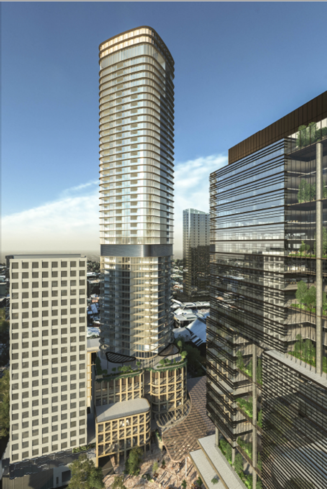
I
Figure 9:
Residential building full height
Vehicle Access, Parking and Loading
A total of 224 car parking spaces would be provided
for residential use within three (3) levels of basement. The basement is
accessible via the proposed loop road (proposed under application WH/2020/467),
with vehicular access located to the northern side of the building on the
lower-ground level.
The proposed vehicle accessway entry would be shared
by both commercial and pedestrian vehicles, and further separated with secure
truck access and loading / unloading facilities and the car basement access to
enable waste and commercial loading for the commercial land uses.
A total of 398 bicycle parking spaces and end-of-trip
facilities would be provided within the lower ground residential bicycle
storage, each accessible from Prospect Street.
End-of-trip facilities include separate male and
female amenities with a total of seven (7) showers, and 22 lockers with access
provided adjacent the commercial entry lobby on the lower-ground level.
The proposal seeks to reinstate the north-south
laneway that provides access between Whitehorse Road and Main Street abutting
the residential buildings podium to the east, providing access through the land
to the southern side Market Street properties as well as the proposed Market
Street building described below.
CONSULTATION
Public Notice and Consultation
The application was advertised by mail to the adjacent
and nearby property owners and occupiers. Following the advertising period nine
(9) objections were received.
A Consultation Forum was held on 07 September 2021 chaired by Councillor Liu. The forum
was held for the broader Stage 1 redevelopment due to the integrated nature of
the works and the total objections received (a total of 40 objections received
for Stage 1).
Objections
The issues raised are summarised as follows:
· Overdevelopment.
· Height and overshadowing.
· Bulk and massing.
· Traffic congestion.
· Wind comfort.
· Reflectivity.
· Limited open space.
· Infrastructure pressures.
· Equitable development opportunity.
· Restricted vehicular access.
· Construction impacts.
A response to each issue is provided within the table below:
|
Objector concern
|
Planning Officer Response
|
|
Overdevelopment
|
The subject site is located within the Major
Development Precinct F, anticipating substantial intensification. The
proposed building responds to its policy setting.
|
|
Height and overshadowing
|
The subject site is located within the Major
Development Precinct F, anticipating substantial intensification of the land.
The proposed height is consistent with the policy
expectations for the land and respects the built form characteristics of the
surrounding area.
The resultant overshadowing has been considered against
the relevant policy and Structure Plan outcomes and generally provides an
acceptable design response with regards to overshadowing.
|
|
Bulk and massing
|
The subject site is located within the Major
Development Precinct F, anticipating substantial intensification of the land.
The building has been designed in accordance with
the relevant built form guidelines of the Structure Plan and provides a level
of detail and architectural merit to eliminate bulk and massing.
The design response has also been considered by an
independent urban design expert who generally supports the proposed built
form. The proposal is generally acceptable against the relevant built form
outcomes.
|
|
Objector concern
|
Planning Officer Response
|
|
Traffic congestion
|
The post-construction outcomes under Stage 1
demonstrate less traffic movements when compared to the existing buildings on
the land, resulting in reduced traffic generation from the site.
The reduced rate of car parking seeks to limit car
parking demand into the centre and achieve a modal shift away from the
private vehicle through provision of a new east-west pedestrian connection
proposed into the office precinct as well as the gifting of land to the
Nelson Road extension at the western side of the site for the future provision
of a rail overpass, supporting active transport from the residential
peripheries.
The proposal generally meets the relevant policy
outcomes sought for land use and car parking.
|
|
Wind comfort
|
The applicant has environmental wind assessments
which demonstrate a variety of comfort conditions that would be acceptable.
|
|
Reflectivity
|
The applicant has submitted a desktop reflectivity
assessment, which demonstrates that glint and glare impacts would be managed
through the design detail phase of construction.
A condition would require a reflectivity assessment
to demonstrate that the proposal will not result in unreasonable glint and
glare to any sensitive receptors.
|
|
Limited open space
|
The proposed building includes internal and external
communal open space areas for future occupants on the top of the podium
level, meeting Clause 58 – Apartment Development standards.
In addition, the proposal is designed to integrate
in with the public realm improvement works made under WH/2020/467 which will
provide additional areas of urban open space.
|
|
Objector concern
|
Planning Officer Response
|
|
Infrastructure pressures
|
The subject site is located within a commercial area
which is fully serviced by existing service infrastructure. There is no
evidence that the existing infrastructure would not be adequate for the
proposed development.
A condition would require civil / drainage plans
which will ensure that the necessary infrastructure is provided commensurate
with the scale of the building.
|
|
Equitable development
|
The proposal demonstrates equitable development
outcomes at both the podium and tower level.
At the podium, the building is constructed primarily
to the boundary to the north, allowing opportunity for a commensurate form
for the adjoining properties.
To the east, the podium maintains a setback through
the laneway, which was refined through discussions with Council’s urban
designer during the application process. A condition would require that the
plans be amended to reflected the without prejudice set that achieves the
equitable development outcomes.
At the tower levels, the building maintains
substantial setbacks from the boundaries, allowing equitable opportunity for
development and amenity, with the only encroachments into the typical 4.5
metre setback being at the buildings edge, which is only for a small section
of built form.
|
|
Restricted vehicular access
|
The proposal does not restrict vehicular access to
properties located to the southern side of Whitehorse Road, which maintain
access from the existing laneway.
Where access is limited to the properties to the
south-western side of Market Street 9due to the proposed enclosing wall to
Main Street), permit conditions ensure that an easement will be created to
allow access rights to these buildings.
|
|
Construction impacts
|
A permit condition will recommend a construction
management plan which will seek to manage any offsite construction impacts.
|
Additional Submissions
A submission under Section 52 of the Planning and
Environment Act 1987 was received by Council from VicTrack on 28/08/2020,
who did not raise concern with the application subject to planning permit
conditions.
EXTERNAL AND INTERNAL REFERRALS
External
|
Referral Authority
|
Type
|
Response
|
|
Department of Transport
|
Section 55 (determining)
|
No objection, subject to planning permit conditions
|
Internal
|
Internal Department
|
Response
|
|
Transport
|
Concerns with the proposed traffic response and
basement layout. To be discussed further below.
|
|
Asset
|
Concerns with the proposed engineering response, subject
to permit conditions. To be discussed further below.
|
|
Design and Construct
|
A number of comments received in relation to the
broader public renewal works. These have primarily been addressed under
WH/2020/467.
|
|
City Works
|
A number of comments received in relation to the
broader public renewal works. These have primarily been addressed under
WH/2020/467.
|
|
Parks and Natural Environment
|
A number of comments received in relation to the
broader public renewal works. These have primarily been addressed under
WH/2020/467.
|
|
Strategic and Landscaping
|
A number of comments received in relation to the
design of the proposed buildings and works. These are addressed further
below, or via permit conditions.
|
|
ESD
|
ESD expectations are met, subject to planning permit
conditions
|
|
Waste
|
Concerns have been raised with respect to collection
of waste for the Market Street building which have since been addressed
within a revised Waste Management Plan.
|
Other External Advice
Council has also referred the application material
externally to both MGS Architects and Vipac Engineers for independent advice on
urban design and environmental wind respectively.
The table below summarises their response:
|
External Referral
|
Response
|
|
MGS Architects
|
Summary:
Subject to the adoption of Recommendations 1 to 13
to the satisfaction of the Council, I support the proposal as one delivering
with its partner projects an exciting new neighbourhood within the centre and
support its approval on Urban Design grounds
The recommendations made by MGS will be discussed
further below.
|
|
Vipac Engineers
|
Summary:
· Vipac have reviewed the environmental wind
assessment and conclude that Mel Consultants have used the proper analysis
and methodology to measure the wind effects on the pedestrian level surrounding
the proposed development.
· Where exceedances of the recommended wind criteria
have been found, appropriate recommendations have been made to mitigate and
improve wind comfort.
|
DISCUSSION
The proposed building, together with the broader
redevelopment of the site under Stage 1 (WH/2020/466 for the office building
and WH/2020/467 for the public realm works) will play a critical role in Box
Hill’s evolution as a vibrant and integrated centre supporting the
delivery of housing within the Metropolitan Activity Centre (MAC) as envisaged
under Clause 22.07 – Box Hill Metropolitan Activity Centre.
Specifically, the proposed building delivers high
quality and affordable housing stock within the centre’s core that is
highly accessible to public transport, services and entertainment, supporting
the anticipated growth of the Centre. The proposed building also includes a
number of commercial land uses, providing additional employment opportunities
and economic benefit.
The proposed building represents an architectural
outcome that is consistent with the built form outcomes of the relevant policy
and Box Hill Transit City Activity Centre Structure Plan 2007 (“the
Structure Plan”), and seeks to enhance the built environment and
immediate public realm, in association with the broader works and landscaping
outcomes proposed under Stage 1.
The assessment below outlines that the proposed
buildings and works provide both an acceptable design response for the site, as
well as the broader Stage 1 applications, as well as a significant net
community benefit for the municipality, generally in line with the policy
direction under the Whitehorse Planning Scheme and Clause 71.02-4 for Integrated
Decision Making.
The two-storey building proposed to Market Street,
including its design, height, shadowing impact and other planning
considerations will be assessed as a separate element to the primary tower.
Net Community Benefit
Pursuant to Clause 71.02-3 for Integrated Decision
Making, Planning and responsible authorities should endeavour to
integrate the range of planning policies relevant to the issues to be
determined and balance conflicting objectives in favour of net community
benefit and sustainable development for the benefit of present and future
generation.
In seeking to balance the competing objectives under
the policy framework applicable to the site, planning officers have been
successful in negotiating a number of outcomes through the application process
that would generate significant net community benefit.
‘Net Community Benefit’ is a planning
concept which has been well established over time, and was enshrined in the
current Victorian Planning Provisions in the late 1990’s. It is the
requirement that a proposal goes beyond balancing the benefits and dis-benefits
of what is proposed, to create an overwhelmingly positive planning outcome.
There are a variety of additions to a proposal that
could be considered to increase the overall community benefit of the proposal,
these may include improved public (indoor or outdoor) spaces or buildings (not
public open space), affordable housing, or other strategically justified use of
benefit to the community (library, kindergarten, community meeting room etc).
Due to the overwhelmingly large demand for affordable
housing in Victoria, the Minister for Planning amended the Planning and
Environment Act (‘the Act’) in 2018 to include that an
objective of the Act is:
(fa) to facilitate the
provision of affordable housing in Victoria.
‘Affordable Housing’ has subsequently been
defined by a Governor in Council Order based on income level, and guidance
support has been provided to Councils and developers to help facilitate
affordable housing as part of development applications. Specifically the Act
supports the use of voluntary section 173 Agreements for affordable housing.
There is also a Ministerial Notice which specifies the matters that must be
considered in determining whether housing provided under an Affordable Housing
Agreement is appropriate for the needs of very low, low and moderate-income
households.
At Clause 22.07 (Box Hill Metropolitan Activity
Centre), the Whitehorse Planning Scheme establishes policy basis for creating
affordable housing in Box Hill. This is supported by state policy at clause
16.01-2S, which has an objective:
·
To
deliver more affordable housing closer to jobs, transport and services.
·
With
various strategies, including:
· Encouraging a significant proportion of new
development to be affordable for households on very low to moderate incomes.
Increase the supply of
well-located affordable housing by:
· Facilitating a mix of private, affordable and social
housing in suburbs, activity centres and urban renewal precincts.
Whilst the Whitehorse Planning Scheme does not include
a specific percentage basis for the provision of affordable housing,
significant strategic planning work across Victoria has established best
practice for the provision of affordable housing around 6%. Examples of this
include:
Port Phillip Planning
Scheme:
- Fishermans Bend – 6%
- Bay Street Activity Centre – 10%
Melbourne Planning
Scheme:
- Fishermans Bend – 6%
- West Melbourne Precinct – 6%
Yarra Planning Scheme:
- Amcor Site – 10%
- Various DPOs – 5%-10%
As such, 6% affordable housing has been used in this
application as an established negotiating point for a voluntary affordable
housing agreement to help achieve net community benefit.
The benefit agreed to be provided by the applicant
through the permit applications to support the proposed development can be
summarised as follows:
· The supply of 6% affordable housing; and
· The replacement of improved wind structures within
Market Street.
This is in conjunction with the delivery of
significant public realm upgrades under the WH/2020/467 application, the
improved east-west pedestrian connection through the MAC and the voluntary
gifting of land to enable the future construction of a north-south railway
overpass.
Overall, the extent of works proposed under Stage 1,
together with the negotiated outcomes to be voluntary delivered by the
landowner result in significant net community benefits for the Box Hill
community. These are discussed in greater detail below.
Policy Framework
Planning Policy Framework (PPF)
The proposal responds to the objective of Clause
11.03-1S for Activity Centres which seeks to encourage the concentration of
various land uses into highly accessible activity centres through a substantial
net increase in high quality housing stock supporting the anticipated growth
within the MAC.
The proposal responds to the objective of Clause
15.01-1S for Urban Design and Clause 15.01-2S for Building Design through a
site responsive design that positively contributes to and enhances the built
form and public realm character of the Box Hill MAC.
The proposal responds to the objective of Clause
15.02-1S Energy and Resource Efficiency by meeting best practice BESS outcomes,
conforming to Council’s ESD expectations under Clause 22.10.
The proposal responds to the objectives of Clause
15.01-4S Healthy Neighbourhoods by proposing a development that provides for
the development of excellent connection opportunities to the nearby walking,
cycling and public transit routes, promoting opportunity for regular and
healthy activity to and from the site by encourage the uptake of alternative
and sustainable transportation.
The proposal responds to the objectives of Clause
16.01-1S for Housing Supply by delivering well-located and diverse housing that
meets the needs of the Box Hill community, and provides access to a number of
public transportation options, services and community facilities.
The proposal also responds to the objectives of Clause
16.01-2S for Housing Affordability through the voluntary supply of 6% of
affordable housing dwellings, as defined by Section 3AA of the Planning and
Environment Act which supports the current shortfall in affordable housing
within the Box Hill area and seeks to deliver more affordable housing within
the MAC, closer to employment opportunities, transport and services.
The proposal responds to the objectives of Clause
17.01-1S for Diversified Economy and Clause 17.02-1S for Business by supporting
employment growth and access to jobs within the MAC through the provision of
approximately 7,615sqm of office floor space and 677sqm of retail floor space
within the buildings podium.
The proposal responds to the objectives of Clause
18.02-1S for Walking and 18.02-2S for Cycling by supporting the uptake of these
modes of transport through a substantial increase in bicycle parking that is
easily accessible from the primary pedestrian network with excellent amenities
for staff and visitors.
The proposal responds to the objective of Clause
18.02-3S for Public Transport by substantially reducing the reliance on the
private vehicle and supporting the uptake of the multitude of nearby public
transport options.
Local Planning Policy Framework (LPPF)
The proposal responds to the vision for Whitehorse
outlined under Clause 21.03 for A Vision for the City of Whitehorse which
seeks to maintain and enhance the built environment to ensure a liveable and
sustainable city by seeking to substantially improve the built environment
within the Box Hill MAC and providing a substantial net increase quality
housing stock supporting the anticipated growth within the MAC.
The proposal responds to the objectives of Clause
21.05 for Environment through the development of an environmentally
sustainable building (Best Practice BESS) and by encouraging the uptake of
sustainable transportation through reduced on-site car parking, enhanced
bicycle facilities and improved connections that substantially improve direct
pedestrian access to the Box Hill public transport interchange, supported by
both Council’s ESD advisor and urban design advice.
The proposal responds to the objectives of Clause
21.07 for Economic Development by facilitating a substantial investment in high
quality office space within the MAC, housed within a contemporary and
attractive built environment.
The subject site is located within the ‘Box Hill
Transport and Retail’ activity precinct and the ‘Major
Development’ built form precinct which together seek to support taller
buildings for a variety of land uses. The proposal responds to the objectives
of Clause 22.07 for the Box Hill Metropolitan Activity Centre through the
delivery of high quality housing stock, supporting the anticipated population
growth of the MAC whilst also providing employment and retail opportunities
through the provision of 7,615sqm of office and 677sqm of retail floor space,
strengthening the role of the MAC as a major commercial hub. In addition, the
proposed building has been designed to respond to its immediate surrounds, with
substantial improvements to the built and the pedestrian environments.
The proposed development demonstrates design
excellence through its architectural quality, materiality and overall design
concept, which also results in further enhancements to the pedestrian
experience of Box Hill with activated frontages. Together with the broader
public realm works will seek to make substantial public realm improvements to
the Box Hill MAC, consistent with the policy objectives of Clause 22.07.
Urban Design
Urban Design Advice
Council have received independent urban design advice from MGS Architects
for the proposed building, which offers a number of key recommendations seeking
to improve the urban design outcomes of the building. These are outlined in the
table below, with planning officer responses:
|
Urban Designer Recommendation
|
Planning Officer Response
|
|
Recommendation 1:
Adopt Equitable development principles for the
setbacks to for the Commercial Tenancies on Ground level to Level 4 inclusive
as follows:
· For the Main Street Building, provide a depth for
the northern light court of 3m from the northern abutment with adjoining
properties.
· For the Market Street and Main Street Buildings,
provide a setback of 3m from the centreline of the eastern laneway.
|
Through subsequent urban design meetings, the
applicant presented without prejudice plans that sought to provide the
necessary setbacks for improved equitable development opportunity.
These modifications were supported by
Council’s Urban Designer, and these plans will be adopted into the
primary set through planning permit conditions.
|
|
Recommendation 2:
Provide a setback of 3m from the northern boundary
interface for the Level 4 podium from the northern boundary interface to
enable the visibility of the form to be addressed within the lower level fine
grain context to the north east and north.
|
As above, through subsequent urban design meetings,
the applicant presented without prejudice plans that sought to provide the
necessary setbacks.
These modifications were accepted by Council’s
Urban Designer, and these plans will be adopted into the primary set through
planning permit conditions.
|
|
Recommendation 3:
A suite of 3- D thumbnail drawings and details are
to be provided at minimum 1:50 detail describing the proposed projecting
blade balcony, plant room floors, planter and bridge details and frontage
details for the Market Street building complete with façade details
and sections to the satisfaction of the council demonstrating the quality,
fitness for purpose and resilience of the materials and approaches adopted.
Review the design language for the north and eastern
sides of the Residential Tower podium facades to ensure each is invested with
the design quality and articulation arising from it scale relative to the
surrounding built form and consistent with the quality and language applied to
the Main Street and Prospect Street interfaces.
|
The submitted drawings from Bates Smart provide a
suitable level of detail for assessment. A façade strategy will form a
condition of any permit granted, which will provide further design detail of
the necessary architectural details and building fittings, to demonstrate the
buildings quality and fitness for purpose.
\
As above, through further subsequent urban design
meetings, the applicant presented without prejudice plans that sought to
reference the design language from the street façade to the north/east
interface. These were supported by Council’s Urban Designer, and these
plans will be adopted into the primary set through planning permit conditions
|
|
Consider the quality and capacity of the lower level
residential access in the light of its obvious role as a drop-off and
collection point for taxis and share transport in particular.
|
The secondary residential access has been
reconsidered in revised plans and maintains a clear point of entry from the ground
floor level, suitable for its intended purpose.
|
|
Recommendation 4:
The Wind assessment and design response is to be
updated to make recommendations for and provide amended drawings to achieve
the following: -
|
The Environmental Wind Speed Measurements (prepared
by Mel Consultants) have been revised several times to ensure acceptable wind
comfort results for both the building and wider pedestrian network.
The proposed building entries and adjoining
pedestrian accessways maintain suitable standing and walking comfort
respectively.
At the upper levels, the communal terraces have been
designed to include a mix of sitting and standing comfort for both short and
long term stationary recreation.
Within the wider network, the proposal demonstrates
a loss of wind comfort within Market Street, however the applicant has
committed to the construction of high quality wind structures to the western
side of the street that will allow for acceptable sitting comfort. These
outcomes will be discussed further in later sections of the report below.
|
|
Recommendation 5:
Reduce the height of the proposed tower to ensure
the south side of the footpath beyond the kerb is not overshadowed after 11am
at the September 22nd equinox to the satisfaction of the responsible authority
|
The applicant has responded to this recommendation
to demonstrate that the proposed building does not result in overshadowing to
the southern side of the Carrington Road footpath at 11am on the Equinox.
|
|
Recommendation 6:
Setback the northern façade of the
residential tower a minimum 4.5 from the northern boundary for the Low rise
and apartments and associated low-rise plant areas.
Amend the arrangements of the northernmost midrise
tower and high rise tower units to further erode the extent of built
from at the northern apex to provide a minimum 4.5 m to balcony edges with
greater setbacks for habitable rooms providing for a progressive reduced
interface intensity above the lower rise levels to the satisfaction of the
Council.
|
Through subsequent urban design meetings, the
applicant presented without prejudice plans that retained the existing
setback of the northern podium, with modified architectural detailing and a
deeper setback to the light-well,
These modifications were supported by
Council’s Urban Designer, and these plans will be adopted into the
primary set through planning permit conditions.
|
|
Recommendation 7:
Provide a subdivision plan clearly denoting the
areas of 24 hour access e.g. to lifts providing connection between Main
Street and Prospect / Clisby Street and transfer of land e.g. interconnection
of Prospect St and Main Street for review and approval by council and a draft
management framework to secure access for the licensed areas to the
satisfaction of Council.
|
A planning permit condition has been recommended
that will require that the landowner enter into an Agreement to ensure that
the lifts are publically accessible on a 24/7 basis and maintained in good
working order.
An additional planning permit condition has also
been recommended under WH/2020/467 (for the public realm works) that would
also require that the landowner enter into an Agreement to ensure that the
areas of public realm proposed will be publically accessible on a 24/7 basis
in perpetuity.
|
|
Recommendation 8:
Consider a condition requiring the retention of
Bates Smart Architects through the project development and delivery and/or a
firm of commensurate record for industry awards across both Residential and
Commercial Buildings to the satisfaction of the Council.
|
A planning permit condition has been recommended to
both this application and the building under WH/2020/466 (office building) to
require the retention of Bates Smart Architect (or firm of commensurate
expertise) through the project development and delivery, ensuring that the
design merit is maintained to commencement of works and beyond.
|
No further recommendations were made, with
Council’s urban designer finding that the proposed building architectural
quality, height and massing were responsive to the site and surrounds.
Building Height and Overshadowing
Building heights within the Box Hill MAC are primarily
guided by two urban design principles established within the Structure Plan
(2007), namely that built form appropriately transitions to the surrounding
residential areas at the edges of the Activity Centre, and that new development
does not cast shadows to Key Public Spaces, peripheral Residential Precincts or
residential areas outside the Activity Centre between 11am and 2pm on 22 June.
In addition to the above, the Structure Plan also
seeks to maintain and improve pedestrian amenity and enhance streets as public
spaces to support and cultivate a range of activity. This is further supported
within the built form guidelines of the Major Development Precinct under Clause
5.2.F which identifies the need to protect the amenity (including access to
sunlight) of streetscapes.
In assessing the appropriateness of the proposed
building height, planning officers refer to the decision guidelines of the
Zone, and the objectives of the Policy Framework and Structure Plan.
Building Height
In determining that the proposed 50-51 storey building
height is an acceptable response to the precincts vision and built form
characteristics, it is first important to understand the context of the site
and surrounding area. The following developments have been constructed or
approved in the immediately surrounding area and are deemed relevant to the
context of the subject land:
· 9-11 Prospect Street: 25 storeys (under construction)
· 34-36 Prospect Street: 30 storeys (approved)
· 820-824 Whitehorse Road: 30 storeys (constructed)
· 826-834 Whitehorse Road: 31 storeys (under
construction)
· 850 Whitehorse Road: 26 and 36 storeys (constructed)
· 545 Station Street: 36 storeys (constructed)
The above approvals / developments are all located on
sites that were suitable for substantial redevelopment due to their size,
consolidation or locational attributes (i.e. major highway interface), and on
the basis that the heights proposed would not result in unreasonable amenity
outcomes such as overshadowing to key open spaces identified in the Structure
Plan (2007) or the priority pedestrian corridors.
The site maintains similar locational
characteristics to the above buildings, being positioned within an
unencumbered, redevelopment site and away from any sensitive residential interfaces
on the periphery of the MAC. However, the subject site is further distinguished
from the above due to its location within the central core of the MAC, between
the existing 36 storey buildings to the east (545 Station Street – Sky
One) and west (850 Whitehorse Road – The Chen) respectively.
As such, whilst the proposed building is taller than
its nearest counterparts to the east and west by 14-15 storeys, the building
would appropriately scale up towards its centralised location within the MAC,
sitting comfortably within the context of the Box Hill skyline and creating a
focal point for the ‘town centre’, providing an appropriately
scaled building in the centre’s core from which future developments can
reference in a ‘scaling down’ towards more sensitive, periphery
area. This responds to the objectives and supporting strategies of
Clause 15.01-1S Urban Design and Clause 15.01-2S Building Design
which require developments to respond to their locational context.
In addition to the built form context above, the
building’s height is further supported through floor area uplift
principles, with the voluntary supply of 6% of affordable housing dwellings as
defined under the Planning and Environment Act 1987 (as well as other
key benefits being offered under stage 1, including the gifting of land for a
future overpass connection; addition east-west connection and substantially
improved public realm open spaces, which are desperately discussed). The
substantial net community benefit being offered by the applicant is
commensurate with the building height proposed, on the basis that the uplift
does not result in any unreasonable overshadowing (as discussed further below).
The proposed construction of a 50-51 storey building
is consistent in the context of the site, responding to the sites locational
attributes and proposing a height that would sit comfortably within the Box
Hill MAC skyline.
Overshadowing
As noted above, existing and approved building heights
within the Box Hill MAC have generally been derived/limited as a result of the
need to limit impacts of overshadowing to residential areas and priority
pedestrian corridors.
The current policy objectives within the Whitehorse
Planning Scheme that are relevant to overshadowing are as follows:
· Built form policy at Clause 22.07 (Box Hill
Metropolitan Activity Centre) encourages development that protects key open
spaces from overshadowing.
· Section 5.2.F of the Structure Plan (2007) for the
Major Development Precinct encourages development to avoid overshadowing
of Key Public Spaces, Peripheral Residential Precincts or residential areas
outside the Activity Centre between 11am and 2pm on 22 June, beyond what would
result from an 11m building over the full extent of the site
· Section 5.2.F of the Structure Plan (2007) for the
Major Development Precinct seeks to protect the amenity (including access to
sunlight) of streetscapes and ‘Key Public Spaces’.
Whilst the Structure Plan does not include an
overshadowing test for the pedestrian network within the MAC, adopting 11am to
2pm at the Equinox is considered to be a balanced assessment approach that is
consistent with a number of Council approved permits on Prospect Street and
further supported by Council’s urban design advice received on the
application.
The table below outlines the relevant areas for protection and the
associated overshadowing tests:
|
Location
|
Overshadowing test
|
Response
|
|
Market Street and Main Street (east) civic plaza
(Key public space within the Structure Plan, 2007)
|
June solstice, 11am to 2pm
|
No shadow impact from the residential building to
Market Street or Main Street east between 11am and 2pm at the Solstice
|
|
Carrington Road
(Key public space within the Structure Plan,
2007)
|
June Solstice, 11am to 2pm
|
No additional shadow impact from the residential
building to Carrington Road between 11am and 2pm at the equinox,
|
|
Hopetoun Parade pedestrian footpath (southern side)
|
September equinox, 11am to 2pm
|
No shadow impact from the residential building to
the southern side of the Hopetoun Parade footpath between 11am and 2pm at the
Equinox
|
|
Thurston Street pedestrian footpath (southern side)
|
September equinox, 11am to 2pm
|
No shadow impact from the residential building to
the western side of the Thurston Street footpath between 11am and 2pm at the
Equinox
|
|
Residential periphery private property (southern
side of Hopetoun Parade / western side of Thurston Street)
|
September equinox, 11am to 2pm
|
No shadow impact from the residential building to
residential periphery between 11am and 2pm at the Equinox
|
The table above demonstrates that the height of the
proposed building would not result in any overshadowing impact to these spaces
between 11am and 2pm at either the Winter Solstice or September Equinox. Where
the proposed building results in shadowing to the Carrington Road
‘Key Public Space’ between 11am and 2pm at the Winter Solstice, the
shadow diagrams demonstrate that this space would already be overshadowed by an
11 metre building over the full extent of the site (meeting the guidance
under the Structure Plan).
The proposed building has been designed to respond to
the immediate context, with the building height not resulting in any
unacceptable overshadowing impact to the existing public realm). This is consistent
with the relevant policy objectives and outcomes applicable to the site, and
demonstrates an outcome that continues to maintain the solar amenity of the
surrounding public open spaces and priority pedestrian network, supported by
the policy outcomes under Clause 22.07 as well as the guidelines of the
Structure Plan (2007).
The expectation of amenity for dwellings within the
residential periphery must be balanced with the increased density being
achieved and anticipated within the MAC consistent with the strategic direction
for the land. In this instance, the areas of private open space that are likely
to be overshadowed will still receive solar amenity during the day beyond 9am
or 10am and the extent of shadowing from the building to the residential
periphery is acceptable when balanced against the strategic intent for the site
and the excellent built form outcomes for the Box Hill MAC.
Built Form
The proposed building design is responsive to the
built form objectives of the Major Development Precinct outlined within the
Structure Plan, and supported by the relevant objectives of Clause 22.07 for
the Box Hill Metropolitan Activity Centre. The built form outcomes sought for
development under Clause 22.07 and the Precinct F built form guidelines of the
Structure Plan can be summarised as follows:
· Articulated building facades and high quality building
materials, demonstrating design excellence and visually interesting built form.
· Podium-tower building formats, with upper levels
recessed to provide ample spacing between high-rise buildings.
· Active street level frontages to enhance the public
realm at ground levels and improve pedestrian permeability.
· Active land uses within the podium to support
opportunities for passive surveillance.
The following sections of the report will assess the
buildings form and architectural arrangements of the building.
Building Setbacks
The built form guidelines of Precinct F encourages
upper level building (tower) setbacks above 12 metres (from Main Street) and 16
metres (from other streets), and seeks to ensure that setbacks between
buildings are sufficient to allow equitable development outcomes.
The building proposes the following upper level
setbacks above the podium at each interface:
· North: tower setback from the apex at 4.5m
· East: tower setback from the apex at 3.995m or 5.515m
to the centre of the adjoining laneway
· South: tower setback from the apex at 1.905m
· West: tower setback from the apex at 12.235m
The tower has been designed as a curved rhomboid
shape, and all setbacks beyond the buildings apex are reduced from the sites
boundaries and podium, minimising bulk and massing when viewed in the round.
The proposed upper level setbacks accord with the
built form guidelines of Precinct F but also seek to reduce bulk and massing at
the upper levels, manage wind conditions and protect daylight access to the
proposed apartments. Greater setbacks have been employed to the more sensitive
interfaces to the north and east, allowing for equitable development outcomes
on adjoining sites and to protect the internal amenity to the proposed
residential dwellings. The towers arrangement is supported by Council’s
urban design advice.
The southern setback of 1.905m to Main Street is as a
result of the setbacks required to the northern boundary to allow for equitable
development opportunities. The proposed setback to the south is offset by the
strength of the podiums base and the width of the proposed Main Street
extension, reducing the towers presence within the public realm.
The podium has been designed primarily to the sites
northern and eastern boundaries adopting equitable development principles.
Greater podium setbacks are proposed around the western Prospect Street
interface, providing additional terrace space for the building, integrating
with the proposed public realm works (under WH/2020/467) and opportunities for
improved access, circulation and passive recreations.
To the north, the podium is located on the boundary,
and adopts a central light-court arrangement with a depth of 3 metres and width
of 14.875 metres. This allows for equitable development opportunities to any
building on the north without compromising daylight access. The land holdings
to the north of the site maintain an aspect to Whitehorse Road for improved
solar amenity, and could adopt a podium and light-court arrangement to the
proposed building. The proposed buildings podium arrangement has been carefully
considered by planning officers with support from Council’s urban
designer.
The proposed building massing is acceptable in its
context, respecting the existing and emerging built form outcomes in the
immediate area, and responding to the policy outcomes sought under the Major
Development Precinct F.
Architectural Expression
The proposed development adopts curved façade
lines and a refined upper level form that presents as visually interesting when
experienced in the pedestrian realm and from afar. This responds to the policy
objectives of Clause 22.07 which encourages design excellence.
The buildings podium and base has been designed with a
curved masonry frame, which adopts a rectilinear pattern. The materiality
wraps around to the northern and eastern elevation, referencing the existing
materiality and fine grain rhythm of Market Street and Main Street.
The podiums curved elements soften the edges of the
public realm, while creating defined points of entry into the building. The
solidity and texture of the masonry improves visual interest within the public
realm, and provides a grounding element to the more refined/elegant tower form
atop. These outcomes are supported by Council’s urban design advice.
At the upper levels, the tower adopts a more
formalised appearance through the use of glazed curtain wall and horizontal
metal bandings. The tower has been designed as a slender rhomboid shape,
forming a sculptural element within the Box Hill skyline. The buildings inset
balconies and wintergardens provide further articulation through the height of
the building. This is supported by Council’s urban design advice.
Planning officers have recommended a condition that requires the permit holder
to retain the project architect (or architect of equivalent experience), to
ensure that the design quality is maintained throughout the design and
construction process.
The proposed design response is well considered,
demonstrating architectural excellence that is consistent with the built form
policy outcomes sought under Clause 22.07.
Public Realm
The majority of the public realm improvements
associated with the Stage 1 redevelopment are the subject of Planning Permit
Application WH/2020/467 (for the public works) and have been designed to
integrate with and compliment the proposed residential/mixed use building.
The public realm works would provide a new pedestrian
connection between Main Street through to Prospect Street and Clisby Court,
substantially improving pedestrian movement and permeability through the MAC.
The western end of Main Street currently terminates at
a loading bay associated with the Woolworths Supermarket, and has limited foot
traffic due to the back of house function of this interface. The proposed
public realm works associated with this residential building would activate the
currently underutilised area at the western end of Main Street, providing
activated tenancies to both Main Street and extending down to Prospect Street,
resulting in significant amenity improvements. This further supports the
east-west connection proposed under WH/2020/467 (public realm works), providing
high-amenity pedestrian access between the public transport interchanges
directly to the Prospect Street office precinct.
The proposed podium has been designed with greater
setbacks around its western edge, providing a partially covered forecourt space
between the buildings primary and secondary entries on the upper ground level
on Main Street. The upper-level terrace includes lift access between the lower
and upper ground levels, and provides further opportunities for passive
recreation through the addition of seating.
The podium provides appropriately scaled glazing areas at the lower and
upper ground levels to ensure a visual connection to the streetscape and
provide opportunity for passive surveillance which is currently lacking under
the existing conditions. Figures 3 and 4 demonstrate the existing Main Street
interface and compares it to the proposed outcomes and compares it to the proposed
public realm outcomes:

J
Figure 10:
Existing Main Street west interface

K
Figure 11:
Proposed Main Street west interface
Pedestrian Amenity
The proposal would enhance the pedestrian environment
through substantive public realm improved associated with the Stage 1
redevelopment of the site.
As part of these improvements, the proposal ensures
that the pedestrian environment maintains high levels of amenity by way of
sunlight, wind comfort (discussed below) and high levels of clear glazing to
provide visual connection and surveillance into the street.
The proposed public realm also make substantial visual
improvements to what is currently a back of house area and car park to the
western end of Main Street and eastern end of Prospect Street through the use
of high quality materials, increased landscaping opportunities and improved
street furniture that seeks to enhance the space for improved passive
recreation and to serve as a genuine urban plaza.
Overall, the proposed areas of public realm maintain
excellent amenity for the pedestrian environment, enhancing the space for its
enjoyment and use.
Market Street Building
In addition to the main residential tower and podium,
the application proposes a two storey commercial building to front Market
Street, which seeks to respond to the existing height and setback
characteristics of the street. The building will be finished in a similar
masonry finish to the podium, with substantial glazing to the frontage,
capturing the fine grain rhythm of the streetscape.
The Market Street would provide passive surveillance
opportunities and activation to Market Street through a ground level retail
frontage and upper level commercial tenancy. A canopy at the ground level will
continue the canopy line that is already present on Market Street to ensure
that the building integrates in with the existing forms. The built form
outcomes for this secondary building are generally acceptable.
The building will include a retail use at ground level
and an office above, both consistent with the purpose of the Commercial 1 Zone,
and the nature of uses existing within the street. Both tenancies are accessed
from the street frontage, with the office utilising a corridor for rear lift
access.
The overshadowing analysis prepared demonstrates that
the proposed building would not result in any additional overshadowing impact
to the Market Street key public space beyond the existing built form, between
11am and 2pm at the June solstice. The shadow outcomes for this secondary
building are acceptable.
The building includes back of house access from the
laneway, with loading / unloading and waste facilities, which have been
reviewed by Council’s relevant departments and confirmed to be
acceptable.
Clause 58 Assessment
Planning officers have assessed the proposal against
the requirements of Clause 58 Apartment Developments and the Apartment Design
Guidelines for Victoria. Broadly, the proposal meets the relevant standards and
objectives of Clause 58.
In determining that the dwellings maintain an
acceptable level of internal amenity, the following objectives have been
further assessed:
· Clause 58.05-1 Accessibility objective
· Clause 58.06-3 Private open space objective
· Clause 58.05-4 Storage objective
· Clause 58.07-1 Functional layout objective
· Clause 58.07-2 Room depth objective
· Clause 58.07-3 Windows objective
· Clause 58.07-4 Natural ventilation objective.
In reviewing the above internal amenity objectives and
relevant standards, it is noted that each standard and objective has been met
with full compliance. There are no concerns with the apartment layouts when
considered against Clause 58 of the Planning Scheme, with each typology
providing an acceptable amenity outcome for future residents.
Wind Comfort
The Environmental Wind Speed Assessment prepared by
MEL Consultants demonstrates acceptable wind outcomes for the buildings entry,
lower and upper ground pedestrian footpath and upper level communal terraces.
The upper ground building residential entry on Main
Street (test locations 18a under Figure 7b of the Environmental Wind Speed
Assessment) demonstrates standing comfort. This meets the expected wind comfort
criteria for building entries.
The upper level (level 3) terrace to the north-western
side of the building at test location P7 demonstrates walking comfort. Whilst
this would be below the preferred comfort level of standing or sitting, it
would still provide opportunities for short-term outdoor recreation, which is
suitable for a terrace space associated with an office building of this scale.
The upper level 5 (residential) communal open spaces
atop of the building’s podium at test locations P1, P2, P3 and P4
demonstrate standing (west) and sitting (east) comfort. This is an acceptable
outcome for the external communal open space providing zoned wind comfort
outcomes that supports a mix of short-long term recreation opportunities, with
additional internal communal open space for windy days. This is a supported
outcome within the MAC, and adopts a consistent approach with other
developments.
The lower ground level pedestrian footpath abutting
the building to the west, up to the edge of Whitehorse Road demonstrates
walking comfort. The upper ground level pedestrian footpath abutting the
building to the south and extending to Market Street demonstrates walking
comfort. These are acceptable for the pedestrian footpath in these locations.
The key public space areas of Market Street and Main Street (east)
result in a loss of wind comfort from existing conditions which is demonstrated
in the . table below:
|
Comfort criteria
|
Existing configuration
|
Proposed configuration
|
|
Sitting
|
4/17, 24%
|
0/17, 0%
|
|
Standing
|
10/17, 59%
|
9/17, 53%
|
|
Walking
|
3/17, 17%
|
8/17, 47%
|
Additional testing under Figure A12 of the wind report
demonstrates that wind speeds improve under the existing wind structures on
Market Street, however it is unclear whether these improvements extend beyond
the structures.
These existing structures are currently located in an
ad-hoc arrangement on Market Street, and with the exception of the structure to
the south-eastern side of the street, are utilised primary for food and drink
seating, with limited benefit to the general public (who are not patrons to the
adjoining food and drink premises). These existing structures are outdated in
terms of their appearance and do not represent excellent public realm outcomes
within an important civic space and therefore provide an opportunity for
improvement to the function of the open space.
Through negotiations during the application process, planning officers
have been able to secure a commitment to construct and replace wind shelter
structures to the south-western quadrant of Market Street. The structures are to
be designed with a consistent materiality and form for visual interest and
provide shelter for both public and private use, delivering equitable outcomes
within the public open space. Figure 5 below shows a typical shelter design:
L
Figure 12:
Typical wind shelter design
Whilst the location of these shelters would require
removal of some vegetation to the south-western side of Market Street, this is
a significant improvement to the comfort of the public realm providing shelter
from wind (both existing conditions as a result of the proposed building) and
other weather conditions, and replacing older existing shelters with an
improved design outcome that benefits a greater proportion of the community.
The remaining areas of Market Street will remain open for clear pedestrian and
emergency access to the north-east and western side of the space. This is a
substantial better outcome than the existing structures within Market Street.
A condition of permit would be recommended that
requires the landowner enter into an agreement to construct these shelters in
accordance with the agreed design option (in consultation with council’s
urban designer), unless at the point of testing (during completion of the
development) the report establishes that wind speeds have since improved and
the shelters are no longer required.
The remaining test locations either remain unchanged
(from the existing wind conditions) as a result of the development, or result
in reductions that would be acceptable in their locational context (i.e.
footpath, other building entries). These can be further addressed and
considered within Stage 2 that would require further mitigation mechanisms.
As such, the proposed wind outcomes resulting from the
building are acceptable.
Building Reflectivity
The applicant has submitted a desktop reflectivity
advice note by Inhabit (October 2020) which provides a proposed pathway that
seeks to address the possible issue of reflected glare stemming from the
building upon the issue of a planning permit and associated permit conditions.
This view has been adopted to ensure that the
reflectivity advice aligns with the timing of the design process, where
specific plans, materials and the like would be selected.
The condition will be applied to any permit granted
and will seek to mitigate hazardous or unreasonable glare to any sensitive
receptors, to the satisfaction of the Responsible Authority.
Landscaping
Landscaping external to the building envelope and
within the immediate surrounds has been further considered and assessed under
Planning Application WH/2020/467 for the public realm works. It is noted that
within this assessment, the landscaping outcomes within the proposed public
realm (urban plaza and street/road extensions) are generous and result in a net
increase in canopy density and soft landscaping, consistent with the policy
expectations under Clause 21.05 for Environment.
Traffic, Car and Bicycle Parking and Loading and
Unloading
Car Parking
The table below demonstrates the following statutory car parking rates
for the proposed building:
|
Description
|
Size
|
Statutory Rate
|
Parking Requirement
|
Parking Provision
|
|
Dwelling
|
One bed
|
64 dwellings
|
0.5 per dwelling
|
32 spaces
|
224 spaces
|
|
Two bed
|
282 dwellings
|
0.75 per dwelling
|
212 spaces
|
|
Three bed
|
20 dwellings
|
1 per dwelling
|
20 spaces
|
|
|
Total
|
264
|
|
Dwelling visitor
|
366 dwellings
|
0.2 visitor spaces to each dwelling for the first
five, plus
0.1 visitor spaces to each dwelling for any
subsequent dwellings
|
73 spaces
|
0 spaces
|
|
Office
|
7,615sqm
|
2 spaces to each 100sqm NFA
|
152 spaces
|
0 spaces
|
|
Retail (shop)
|
677sqm
|
3.5 spaces to each 100sqm of LFA
|
23 spaces
|
0 spaces
|
|
Total
|
480 spaces
|
224 spaces
|
A total of 224 car parking spaces are proposed to be
provided, and therefore a reduction of 256 car parking spaces is sought. This
equates to a rate of 0 spaces for office and retail uses, 0 spaces for visitors
and a reduced number of spaces for some residential dwellings (to be determined
through allocation).
Council’s Transport Engineering department
acknowledges the strategic intent to provide less parking on the site, but
suggests that the reduction is too substantial without further specific
justification.
Through the application process, Planning Officers
however have reviewed the Traffic Impact Assessment (GTA Consultants, dated
04/02/2021) as well as the policy framework for the site and wider MAC, and
consider the reduction to be acceptable for the proposed land uses in this
particular location. This is based primarily on the following factors:
· The policy framework for parking within the Box Hill
Metropolitan Activity Centre;
· The commercial land uses and the type of car parking
demand generated;
· The opportunity to improve and increase pedestrian and
alternatives modes of transportation through the provision of the Main Street
extension through to Prospect Street and the availability of land for future
bicycle connectivity;
· Parking opportunities off-site and away from the
retail core;
· The market led demand for residential vehicle parking;
and
· The opportunity to reduce parking and vehicle
movements into the retail core.
Policy Framework
The car parking objectives of Clause 45.09 Parking
Overlay – Schedule 1 for the Box Hill Activity Centre encourage the
promotion of active and sustainable travel modes rather than increase private
vehicle travel. This objective is tied to outcomes geared towards locating and
managing the provision of car parking within the MAC so as to minimise traffic
generated by the search for a parking space in areas already experiencing high
traffic levels. Whilst minimum parking rates are specified for dwelling and
office land uses within the Parking Overlay, there is an opportunity to reduce
the parking provided for a land use should the car parking objectives be
achieved. As noted in the following assessments, the reduced rate continues to
respond to the objectives of the Overlay.
The PPF and LPPF both support reduced parking rates
within Activity Centres and specifically the Box Hill Metropolitan Activity
Centre. Within the PPF, Clause 18.01-3S (Sustainable and Safe Transport)
includes strategies that support development which promotes walking, cycling
and the use of public transport, (in that order), and minimise car dependency.
Similarly, both Clause 18.02-1S (Walking) and Clause 18.02-2S (Cycling) seek to
increase the uptake of walking and cycling through the provision of priority
networks that link in with nearby public transportation links and interchanges.
Clause 22.07 (Box Hill Metropolitan Activity Centre)
includes objectives which encourage walking, cycling and the uptake of public
transport in favour of reduced private vehicle usage as well as managing
parking supply to support choice of travel mode, and a balance between access,
sustainable transport and land use needs within the Centre. The proposed land
uses and car parking arrangement is supported by the above policy objectives
through the location of the site, its proximity to transportation, the limited
parking supply and the quality of bicycle facilities.
The proposal responds to these policy outcomes by
reducing the rate of parking primarily for the commercial land uses, with some
reductions proposed to dwellings and by extension reducing private vehicle
demand and trips within the core retail precinct. The proposal also would substantially
improve the pedestrian network through the construction of an east-west
priority pedestrian connection that links the enterprise precinct of Prospect
Street directly to the Box Hill public transport interchanges, substantially
encouraging and increasing the uptake of alternative travel modes.
Reduced Reliance on the Private Vehicle
The Integrated Transport Strategy (adopted by Council
21 September 2020) identifies a number of critical transport issues within the
MAC and opportunities available for improvements. Relevant to this application
are the following:
· The car parking requirements for new developments are
not sustainable within the anticipated population and employment growth.
· Active transport participation amongst residents,
workers and visitors is very low.
Expanding on the above points, the Strategy indicates
that the allocation of road space is inefficient and a key factor in the
congestion on the road network, with resulting adverse economic, environment
and social impacts to the community. This is linked to the issue of low active
transport participation within the MAC, through limited allocated of road
reserve to the private vehicle in lieu of walking and cycling links.
The proposal responds to and seeks to alleviate the
above issues by proposing a substantial reduction in parking (both from the
proposed office, retail and residential uses and the demolition of the existing
retail parking), which results in substantially less private car movements into
the MAC and specifically the retail core as a result of the development.
Furthermore, the proposal also seeks to expand the
priority pedestrian network and contribute to the provision of bicycle
infrastructure through the provision of a new east-west connection between Main
Street and Prospect Street, as well as allocating land for the future
construction of a north-south rail overpass. This seeks to reallocate existing
land within the MAC for dedicated pedestrian activity and provide an
opportunity for improved active transport amongst residents by connecting the
residential peripheries into the Centre. Both outcomes result in reduced
reliance of the private vehicle for the site and proposal, but continue to
facilitate a change in approach for future transport planning within the MAC.
Commercial demand
The proposal seeks to use part of the land for office
and retail and reduces the rate of parking for both. It is an established
planning principle (see KM Tram Enterprise Pty Ltd v Boroondara CC [2018]
VCAT 1237) that (office) staff parking demands are typically a function of
supply, and in locations where on-street parking is constrained by time
restrictions or limited parking availabilities, staff elect to utilise
alternate transport modes where available. It is the view of planning officers
that this principle can be equally applied for retail land uses, due to their
similar commercial nature.
The reduced rate of parking provided for the
proposed office and retail uses seek to facilitate a modal shift away from the
private vehicle, and to encourage staff to utilise the excellent offering of
public transportation within the MAC. This is supported by the objectives of
Clause 22.07 and Section 4.4.E of the Structure Plan.
Empirical evidence provided within the Transport
Impact Assessment, prepared by GTA Consultants (February 2021) further supports
the reduced parking rate for office land uses, demonstrating an average parking
rate of 0.77 spaces per 100sqm.
In this instance, Council supports a further reduced
rate of 0 spaces for office and retail on the basis that:
· The reduced supply of parking encourages the uptake of
public transport for office and retail land uses;
· The proximity of the building to the numerous public
transport options within retail core supports the above proposition;
· The substantially improved east-west connection from
the station directly into the office precinct supports greater pedestrian
activity;
· The parking reductions support a sustainable mode
shift that supports reduced vehicle movements within the centre; and
· The bicycle parking and high amenity end-of-trip
facilities encourages workers to cycle to work.
Whilst this application seeks to provide a zero rate
for parking compared to the 0.48 rate proposed under the office tower
(WH/2020/466), the office use is reduced in scale compared to its purpose built
counterpart with less parking demand generated (34 spaces based on a rate of
0.48 per 100sqm). As such, if any person still elects to drive, any potential
overflow resulting from the zero rate of parking could easily be captured
within a number of public parking options available with the centre.
Public Transportation
Given the site’s locational attributes within
the MAC and the alternative transport offerings available (rail, bus and tram
all within 150 metres walking distance), it is anticipated that the demand
generated for the proposed land uses will be limited to the on-site provision
of parking available with the remainder utilising the excellent public
transport options available within immediate proximity of the proposed
building. This is supported by the decision guidelines for parking reductions
under Clause 52.06-7.
The proposed connection into Main Street as well as
the gifting of land for a future north-south, bicycle overpass (connecting the
residential peripheries) further substantiates the reduction of car parking by
demonstrating a clear intent to change user behaviour within the MAC by
providing substantially improved walking and cycling conditions within the
Centre.
In addition to the existing public transport network,
the Suburban Rail Loop (SRL) has recently been announced which proposes a new
station within the Box Hill transport hub, directly connecting the MAC to
adjacent middle suburban regions and activity centres. Whilst limited weight
can be given to the Environmental Effects Statement at this point in time, the
proposed concept significantly increase accessibility into the MAC from the
outer regions, again supporting reduced parking demand within commercial land
uses at this location.
Off-site parking opportunities
Council manages a number of public car parks within
the Box Hill MAC (excluding short-term timed parking), including:
· 5 Watts Street (260m from the site with 468 spaces);
· 2-10 Harrow Street (300m from the site with 562
spaces); and
· 20-24 Ellingworth Parade (380m from the site with
approx. 93 spaces).
In addition to the above, there is additional private
owned public parking within the existing Box Hill Central South shopping centre
(886 spaces) at 1 Main Street.
Together with the above Council owned car parks, there
are a number of publically available spaces within the MAC, at a suitable
walking distances to the site.
These offsite parking options will cater for any
overflow parking demand generated from the commercial uses and residential
visitors should they elect to drive. Both vehicle users will have a clear
understanding that there will be no on-site parking for these purposes, and
will therefore need to find a suitable alternative. As these public parking
options are typically on the periphery of the centres, it avoids the need for
vehicles to drive into the retail core where traffic impacts are typically at
their worst.
As noted in the above justification, whilst demand
will be supressed by the reduced supply of parking, some may continue to elect
to drive. However, even if with overflow parking, the post-completion traffic
conditions from Stage 1 will still result in similar or substantially reduced
vehicle movements based on the number of spaces, and as such, any overflow
generation is still likely to fall within the existing conditions of the site.
Residential vehicle parking
The application seeks to reduce the rates for visitor
(full reduction) and residential car parking (40 spaces). These residential
reductions are acceptable for the site in its location.
For the residential dwellings, the reduction of 40
spaces is acceptable due to the opportunity for residents to take public or
alternative transportation on an as-needs basis. In addition, dwellings will be
sold without car parking spaces and therefore prospective property owners will
have a clear understanding that there will be no allocated car parking space on
the site, and parking off-site will be costly and difficult to manage. Similar
to the discussion above pertaining to office parking, the demand of parking is
managed by the provision provided for residents, who have choice to decide on
whether they purchase without parking availabilities.
The reduction of visitor car parking is acceptable in
this particular location of the MAC due to the opportunity to take public
transportation into the MAC and walk to the building through the improved
public realm connections, or as an alternative park within one of the nearby
off-site public car parks as described above, which are designed to cater for
any overflow generated by the development.
Importantly, the context of the subject site is
different to others within the MAC, which may not be afforded with the same
level of access to public transport and pedestrian convenience, and may not
have nearby supporting infrastructure (such as car parks) to respond to any
overflow. Visitor parking reductions need to be individually considered within
their locational context.
Traffic Impacts
The SIDRA intersection modelling presented within the
submitted Transport Impact Assessment, prepared by GTA Consultants (February
2021) indicates that there are moderate to high levels of existing traffic
congestion in Box Hill at present, with these levels expected to marginally
worsen with the continued development of the area. At present, the existing
road network operates within acceptable limits during the PM peak hour
(congestion higher during weekday PM peak).
However, with existing levels of road-based congestion
expected to increase in Box Hill due to the substantial building
intensification and density being accepted within the MAC, a typical approach
to transport planning, which adopts greater rates for private vehicle parking
is unsustainable and would further intensify traffic and congestion on the
local road network within the MAC, degrading the public realm and reducing
opportunities for active transport, all of which are sought within the relevant
local policy and the recently adopted Integrated Transport Strategy outlined
above.
The proposal adopts an alternate approach that seeks
to prioritise and shift behaviours away from the private vehicle and into
walking, cycling and public transport, and as a result of this method
demonstrates significantly reduced vehicle movements associated with the
proposed building and through the demolition of the existing retail car
parking.
Empirical evidence outlined within the Transport
Impact Assessment, prepared by GTA Consultants (February 2021) indicates that
residential car parking spaces generally generate traffic movements at a rate
of 0.15 vehicle movements per car per hour. Application of these rates to the
proposed provision of 224 car parking spaces indicates that the development
could be expected to generate up to approximately 34 vehicle movements in any
peak hour (best-case scenario). This generation rate can be accommodated into
the existing road network based on the SIDRA analysis prepared.
In a scenario where people elect to drive to the site,
the demands generated by residential visitors, office, retail and continues to
be low (10 movement for visitors and 15 movements for commercial uses on
similar rates adopted under WH/2020/466 for the office building and those
specified within the Transport Impact Assessment), which can equally be
accommodated into the existing road network, as demonstrated by the worst-case
SIDRA analysis for the wider road network.
However, taking a more holistic approach for the site
and acknowledging the post-development conditions of Stage 1, the total traffic
generation identified by the traffic impact assessment post development will
be:
· Lower than the existing shopping centre use of the
site during the critical weekday afternoon peak hour (-115 movements).
· Significantly lower than the existing use of the site
during the Saturday lunchtime peak hour (-295 movements); and
· Generally consistent with the existing use of the site
during the weekday morning peak hour (+6 movements), which can currently be
accommodated in the existing road network.
The outcomes above are primarily due to the demolition
of the existing shopping centre which incorporates a greater number of car
parking spaces compared to the post development conditions. The data within
Table 5.3 of the Transport Impact Assessment, prepared by GTA Consultants
(February 2021) prepared demonstrates that there are substantial reductions in
traffic generation between the existing centre and the post-development
conditions under Stage 1 (if approved).
This concludes that the redevelopment of site would
result in decongestion to the road network at the current rates of car parking.
The traffic impact assessment has also adopted a worst-case scenario of the
SIDRA analysis with a 20% increase (buffer) in traffic which continues to
demonstrate adequate traffic conditions. Noting the above, the proposed
building would not result in unreasonable traffic impacts to the existing and
proposed road network.
Whilst Council’s traffic engineering department
do not agree with the submitted outcomes of the Transport Impact Assessment,
the following responses are provided to their concerns:
· The adopted generation rates are based on a low rate
of parking, which is to achieve a significant change in behaviour and modal
shift away from the private vehicle use, which is an adopted Council position
through the Integrated Transport Strategy.
· The use of the road extension as a ‘rat
run’ is unlikely due to the significant pedestrianisation of the street
network including the raised flush pedestrian crossing. Vehicles typically
drive slower where the boundaries between pedestrian and vehicle are blurred,
which limits the use of the street as a run between Whitehorse Road and Elgar
Road.
· The proposed road extension is likely to be utilised
by people accessing the development sites, and given that the traffic
generation of these sites is identified as low (as specified within Table 5.3),
it is unlikely that there will be vehicle queuing. The applicant has included
queuing analysis, which concludes that there will be no traffic impact to the
road network as detailed within the Transport Impact Assessment.
· The proposal is DDA compliant, with conditions of
permit requiring a DDA accessibility plan and audit.
· The southern side of Prospect Street
(post-development) does include street furniture, but maintains unencumbered
access and clear sightlines through its central corridor for those with vision
impairments.
· Visibility sight lines have been considered within the
relevant traffic impact assessments and deemed acceptable.
· The length of the car parking spaces to the edge of
the proposed road extension are measured at 6.7 metres, which meets the
relevant Clause 52.06-9 standards for parking space length.
Bicycle Parking
The table below demonstrates the following statutory bicycle parking
rates for the building:
|
Description
|
Size
|
Statutory Rate
|
Parking Requirement
|
|
Employee/
resident
|
Visitor
|
Employee
|
Visitor
|
|
Residential
|
366
|
1 to each 5 dwellings
|
1 to each 10 dwellings
|
76 spaces
|
38 spaces
|
|
Office
|
7,165sqm
|
1 to each 300sqm
|
1 to each 1,000sqm
|
23 spaces
|
7 spaces
|
|
Retail
|
677sqm
|
1 to each 300sqm
|
2 plus 1 to each 200sqm
|
2 spaces
|
5 spaces
|
|
Total
|
101 spaces
|
50 spaces
|
The proposed development includes a total of 396
bicycle parking spaces, including 366 secure resident spaces on the lower
ground level, and 30 commercial and retail spaces on the lower ground level in
conjunction with end-of-trip facilities. The provision significantly exceeds the
statutory requirement and continues to demonstrate a substantial modal shift
away from the private vehicle.
The end-of-trip facilities within the building are
located at the lower ground level and accessed from Prospect Street (adjacent
the primary commercial building entry) with separated male / female facilities
(including showers and lockers). Both facilities exceed the number of showers
and lockers required pursuant to Clause 53.34 for Bicycle Facilities.
The end-of-trip facilities are easily accessible from the public realm and
provide excellent amenities for staff.
The proposed bicycle layout has been reviewed by
Council’s transport engineering department, and no concerns have been
identified. This indicates that the bicycle parking spaces are easily
accessible for use.
Basement Layout
The basement layout has been reviewed by
Council’s Traffic Engineering department. The following assessment is in
response to the comments made within the referral response that are to be
addressed via planning permit conditions or require further consideration:
· Visibility splays have not been provided at the
pedestrian edge of the lower-ground access. A condition of permit through the
car parking management plan will require any visibility issues and conflicts
between pedestrians and vehicles.
· Allocation of car parking (including DDA parking) will
be identified within any car parking management plan required as permit
conditions.
· The location of electrical parking spaces is
acceptable, with the total provision of 12 charging stations.
· There is no requirement for motorcycle parking with
Clause 52.06.
The proposal meets all other relevant standards of
Clause 52.06-9. The basement layout is therefore acceptable.
Loading and Unloading
Commercial vehicle loading / unloading and waste
collection is proposed to the rear of the residential building and accessed via
the lower-ground access from the loop road.
The loading / unloading and waste collection has been
reviewed by the relevant traffic and waste departments and are supported
subject to necessary planning permit conditions for loading management.
Swept path diagrams for both the primary residential
building as well as the secondary Market Street building have been provided to
demonstrate that vehicles can enter and exit the site in a forward direction,
safely and efficiently.
EASEMENTS
Due to the enclosure of Main Street (under WH/2020/467
for public realm improvements), vehicular access to the southern side
Market/Main Street tenancies at 23-27 Market Street and 42-50 Main Street would
be limited.
To ensure that these buildings maintain access rights
upon completion of the development, a condition of permit would require the
registration of easement through the length of the re-established laneway that
would be maintained under Vicinity ownership.
This laneway will be accessed via the existing
crossover on Whitehorse Road and provide connection to each abutting tenancy
from its rear.
CONCLUSION
The application has been considered against and
responds to the relevant objectives within the Planning and Local Planning
Policy Framework.
The proposed building has policy support for built
form intensification, being located within major development Precinct F, and
further supports population growth and economic diversity within the MAC
through the substantial increase of both dwellings and office and retail floor
space.
The proposed building has been carefully sited and
designed to limit offsite impacts from both visual bulk and massing as well as
the impact of overshadowing to the public realm and private residential land.
The proposed building has also demonstrated a
substantial net community benefit through the voluntary supply for 6% of
affordable housing dwellings within the building, supporting the shortfall of
these types of accommodation identified within the Box Hill area.
A total of twenty (25) objections were received as a
result of public notice and all of the issues raised have been discussed as
required. It is considered that the application should be approved, and a Notice
of Decision to Grant a Planning Permit be issued.
Attachment
1 Public
Realm Works - Development Plans 
2 Commercial
Tower - Development Plans
3 Residential
Tower - Development Plans