Ordinary
Council Meeting
To be held in the
Council Chamber
Nunawading Civic Centre
379 Whitehorse Road Nunawading
on
Monday 20 August 2018
at 7:00pm
Members: Cr
Andrew Davenport (Mayor), Cr Blair Barker, Cr Bill Bennett,
Cr Raylene Carr, Cr Prue Cutts, Cr Sharon Ellis, Cr Tina Liu,
Cr
Denise Massoud, Cr Andrew Munroe, Cr Ben Stennett
Ms Noelene Duff
Chief Executive Officer
|
Audio Recording of Meeting and Disclaimer
Councillors and members
of the public please note that in order to provide greater access to Council
debate and decision making and encouraging openness and transparency:
- Formal Public Committee and
Council meetings are audio recorded and the recordings (except for
Confidential meetings) are uploaded and available on Council’s
website
- Opinions expressed or statements
made by individual persons during a meeting are not the opinions or
statements of Whitehorse City Council and therefore Council accepts no liability.
|
Ordinary Council Meeting 20
August 2018
AGENDA
1 PRAYER
1a Prayer
for Council
We give thanks, O God, for the Men and Women of the past whose
generous devotion to the common good has been the making of our City.
Grant that our own
generation may build worthily on the foundations they have laid.
Direct our minds
that all we plan and determine, is for the wellbeing of our City.
Amen.
1b Aboriginal
Reconciliation Statement
“In the
spirit of reconciliation, Whitehorse City Council acknowledges the Wurundjeri
people as the traditional custodians of the land we are meeting on. We pay our
respects to their Elders past and present.”
2 WELCOME
AND APOLOGIES
Cr Carr has previously sought
and been granted leave of absence for tonight’s Ordinary Council Meeting
20 August 2018.
Cr Ellis has sought a leave of
absence for the Ordinary Council Meeting held on 17 September 2018.
RECOMMENDATION
That the apology for Cr
Ellis be received and leave of absence be granted for the Ordinary Meeting held
on 17 September 2018.
3 DISCLOSURE
OF CONFLICT OF INTERESTS
4 CONFIRMATION
OF MINUTES OF PREVIOUS MEETINGS
Minutes of the Ordinary Council Meeting 16 July 2018
|
RECOMMENDATION
That the minutes of the Ordinary Council Meeting
16 July 2018 having been circulated now be confirmed.
|
5 RESPONSES
TO QUESTIONS
6 Notices
of Motion
6.1 Notice of Motion No 112 -
Cr Barker
|
Refer to Confidential Item 6.1
|
7 Petitions
8 Urgent
Business
Ordinary Council Meeting 20
August 2018
9 Council
Reports
9.1 City
Development
Statutory Planning
9.1.1 203
Canterbury Road, BLACKBURN (Lot 1 TP 872902D) – Construction of Four (4)
Double Storey Dwellings, Removal of Vegetation and Alteration of Access to a
Road Zone, Category 1
FILE NUMBER: WH/2017/789
ATTACHMENT
SUMMARY
This application was advertised
on 16th March 2018, following which a total of twenty-four (24)
objections were received. The objections raised issues with regard to
neighbourhood character, landscape character, parking and traffic, amenity
impacts and vegetation removal. A Consultation Forum was held on Tuesday 5th
June 2018 and chaired by Councillor Massoud, at which the issues were explored,
however no resolution was reached between the parties.
A section 57A amendment to the
application was lodged on 6th July 2018, seeking to address outstanding
concerns of Council and issues raised by objecting parties. These amended plans
have not been re-advertised as the changes do not result in additional material
detriment to adjoining owners and occupiers.
The amended
plans introduce a number of positive changes to the proposal, namely reduced
floor area/site coverage, increased side setbacks, increased retention of
existing vegetation, increased canopy tree planting and generally reduced
building bulk. There remain some outstanding matters with regard to tree
planting and landscaping outcomes/design which can be addressed through permit
conditions.
This report assesses the application against the relevant
provisions of the Whitehorse Planning Scheme, as well as the objector
concerns. It is recommended that the application be supported, subject to
conditions.
|
RECOMMENDATION
That Council:
A. Being the Responsible Authority, having
caused application WH/2017/789 for 203 Canterbury Road, BLACKBURN (Lot 1 TP
872902) to be advertised and having received and noted the objections is of
the opinion that the granting of a Planning Permit for the Construction of
Four (4) Double Storey Dwellings, Removal of Vegetation and Alteration of
Access to a Road Zone, Category 1 is acceptable and should not unreasonably
impact the amenity of adjacent properties.
B. Issue a Notice of Decision to Grant a Permit
under the Whitehorse Planning Scheme to the land described as 203 Canterbury
Road, BLACKBURN (Lot 1 TP 872902) for the Construction of Four (4) Double
Storey Dwellings, Removal of Vegetation and Alteration of Access to a Road
Zone, Category 1, subject to the following conditions:
1. Before
the development starts, or vegetation is removed, amended plans (two full
size copies) must be submitted to and approved by the Responsible
Authority. When approved, the plans will be endorsed and will then form
part of the permit. The plans must be drawn to scale, with dimensions,
and be generally in accordance with the plans submitted with the application
but modified to show:
a) The
locations of Tree Protection Zones described in Condition 5, with all
nominated trees clearly identified and numbered on both site and landscape
plans, and the requirements of Conditions 5 and 6 to be annotated on the
development and landscape plans.
b) Increase
in Dwelling 1 setback from side (eastern) boundary to be 6.4 metres and
removal of landscaping strip, and replacement to allow for increased area for
vehicular ingress and egress manoeuvring and appropriate vehicular access.
c) Relocation
of Dwelling 1 clothesline and removal of paved pathway to provide for
continuation of landscape planting/vegetation buffer along sites western
boundary.
d) Increase
in Dwelling 2 and 3 setback from side (western) boundary to 5.0 metres
without alteration to any other setbacks.
e) Removal
of retaining wall and paved area adjoining Dwelling 3 Garage and relocation
of clothes line to provide for additional landscaping and canopy tree
planting opportunity.
f) Removal
of paved area to Dwelling 3 adjoining western side dwelling (adjoining ground
floor laundry and living area) to provide for additional landscaping and
canopy tree planting opportunity.
g) Removal
of lawn area located along Dwelling 3 western boundary (adjoining ground
floor laundry and living area) to provide for continuation of landscape
planting/vegetation buffer along site’s western boundary.
h) Removal
of paved area adjoining Dwelling 4 Garage (adjoining eastern boundary) to
provide for continuation of landscape planting/vegetation buffer along sites
eastern boundary.
i) Increase
in Dwelling 4 setback from rear (northern) boundary to 6.5 metres to provide
for additional landscaping and canopy tree planting opportunity.
j) Increase
in Dwelling 4 setback from side (eastern) boundary to 5.0 metres to provide
for additional landscaping and canopy tree planting opportunity.
k) Paving
within secluded private open space areas of Dwellings 1 and 2 to have a
maximum width of 2.5 metres to provide for additional landscaping and canopy
tree planting opportunity.
l) Paving
within secluded private open space areas of Dwellings 3 and 4 to have a maximum
width of 3.0 metres to provide for additional landscaping and canopy tree
planting opportunity.
m) No
soil level changes within 4.9 metres of Tree 7 (Eucalyptus cladocalyx –
Sugar Gum).
n) No
soil level changes within 2.7 metres of Tree 8 (Eucalytpus sideroxylon
– Ironbark).
o) Sight
line triangles in accordance with Design standard 1 – Access ways of
Clause 52.06 of the Whitehorse Planning Scheme.
p) Water
tanks to be located outside of Tree Protection Zones and proposed Tree
Planting Envelopes to the satisfaction of the Responsible Authority.
q) Notation
on site plans indicating that all obscured glazing be manufactured obscured
glass. Obscure film being applied to clear glazing will not be
accepted.
r) An
amended materials schedule showing metal clad finishes (MC01) external to
dwellings to be more muted in colour and of an ‘earthy tone’.
s) An
amended landscape plan in accordance with Condition 3 of Permit.
t) A
Waste Management Plan in accordance with Condition 9 of Permit
u) A
Sustainable Design Assessment in accordance with Condition 10 of Permit.
All of the above requirements must be to the
satisfaction of the Responsible Authority.
Once approved these plans and documents become the
endorsed plans of this permit.
2. The
layout of the site and the size, design and location of the buildings and
works permitted must always accord with the endorsed plan and must not be
altered or modified without the further written consent of the Responsible
Authority.
3. No
building or works shall be commenced (and no trees or vegetation shall be
removed) until a landscape plan prepared by a suitably qualified and
experienced person or firm has been submitted to and endorsed by the
Responsible Authority. This plan when endorsed shall form part of this
permit. This plan shall show -
a) A survey
of all existing vegetation, abutting street trees, natural features and
vegetation.
b) Buildings,
outbuildings and trees in neighbouring lots that would affect the landscape
design.
c) Planting
within and around the perimeter of the site comprising trees and shrubs
capable of:
i. Providing
a complete garden scheme,
ii. Softening
the building bulk,
iii. Providing
some upper canopy for landscape perspective,
d) A
schedule of the botanical name of all trees and shrubs proposed to be
retained and those to be removed incorporating any relevant requirements of
condition No. 1.
e) The
proposed design features such as paths, paving, lawn and mulch.
f) A
planting schedule of all proposed vegetation (trees, shrubs and ground
covers) which includes, botanical names, common names, pot size, mature size
and total quantities of each plant.
g) Provision
of a minimum of six (6) canopy trees of indigenous species capable of
reaching a maximum height of 15 metres at maturity, situated in minimum areas
of 50sqm of open ground with a minimum dimension of 5 metres that is free of
buildings and impervious surfaces and of other tree canopies to minimise
competition and facilitate normal growth.
Landscaping in accordance with this approved plan
and schedule shall be completed before the building is occupied.
Once approved these plans become the endorsed
plans of this permit.
4. The
garden areas shown on the endorsed plan and schedule shall only be used as
gardens and shall be maintained in a proper, tidy and healthy condition to
the satisfaction of the Responsible Authority. Should any tree or shrub
be removed or destroyed it may be required to be replaced by a tree or shrub
of similar size and variety.
5. Prior
to the commencement of any building and or demolition works on the land, a
Tree Protection Zone (TPZ) must be established on the subject site and
maintained during and until completion of all buildings and works including
landscaping, around the following trees in accordance with the distances and
measures specified below, to the satisfaction of the Responsible Authority:
a) Tree Protection Zone distances:
i. Tree
7 (Eucalyptus cladocalyx – Sugar Gum) – 7.1 metre radius from the
centre of the tree base.
ii. Tree
8 (Eucalyptus sideroxylon – Ironbark) – 3.9 metre radius from the
centre of the tree base.
iii. Tree
10 (Eucalyptus camaldulensis – Red Gum) – 6.3 metre radius from
the centre of the tree base.
iv. Tree
11 (Eucalyptus ovata – Swamp Gum) – 5.9 metre radius from the
centre of the tree base.
v. Tree
12 (Eucalyptus cladocalyx – Mahogany Gum) – 4.4 metre radius from
the centre of the tree base.
vi. Tree 14
(Eucalyptus sideroxylon – Ironbark) – 7.4 metre radius from the
centre of the tree base.
b) Tree
Protection Zone measures are to be established in accordance to Australian
Standard 4970-2009 and including the following:
i. Erection
of solid chain mesh or similar type fencing at a minimum height of 1.8 metres
held in place with concrete feet.
ii. Signage
placed around the outer edge of perimeter fencing identifying the area as a
TPZ. The signage should be visible from within the development, with the
lettering complying with AS 1319.
iii. Mulch
across the surface of the TPZ to a depth of 100mm and undertake supplementary
watering in summer months as required.
iv. No
excavation, constructions works or activities, grade changes, surface
treatments or storage of materials of any kind are permitted within the TPZ
unless otherwise approved within this permit or further approved in writing
by the Responsible Authority.
v. All
supports, and bracing should be outside the TPZ and any excavation for
supports or bracing should avoid damaging roots where possible.
vi. No
trenching is allowed within the TPZ for the installation of utility services
unless tree sensitive installation methods such as boring have been approved
by the Responsible Authority.
vii. Where
construction is approved within the TPZ, fencing and mulching should be
placed at the outer point of the construction area.
viii. Where
there are approved works within the TPZ, it may only be reduced to the
required amount by an authorised person only during approved construction
within the TPZ and must be restored in accordance with the above requirements
at all other times.
6. During
the construction of any buildings or works, the following tree protection
requirements must be carried out to the satisfaction of the Responsible
Authority:
a) The
driveway where within the TPZ’s of Trees 7 and 8 must be constructed
above the existing soil grade using porous materials that allow water to
penetrate through the surface and into the soil profile. There must be no
grade change within greater than 10% the TPZ’s and no roots greater
than 40mm in diameter are to be cut or damaged during any part of the
construction process.
b) Dwelling 3 where within the
TPZ or Tree 10 must be constructed on tree sensitive footing or screw piles,
with no grade change within the TPZ. The post holes are to be hand dug and no
roots greater than 40mm in diameter are to be cut or damaged.
c) The paved areas where within
the TPZ’s of Trees 2, 4 and 10 must be above the existing soil grade
using porous materials that allows water to penetrate through the surface and
into the soil profile. There must be no grade change within greater than 10%
of the TPZ’s and no roots greater than 40mm in diameter are to be cut
or damaged during any part of the construction process.
d) All buildings and works for
the demolition of the site and construction of the development (as shown on
the endorsed plans) must not alter the existing ground level or topography of
the land within greater than 10% of the TPZ’s of Trees 3, 11 and 12.
7. Prior
to the commencement of the development permitted, the owner shall enter into
an agreement with the Responsible Authority to its satisfaction pursuant to
the provisions of Section 173 of the Planning and Environment Act 1987 in
which it shall be covenanted that:
a) On-going maintenance to occur on the paving of the driveway where
within the Tree Protection zone of Tree 7 (Eucalyptus cladocalyx –
Sugar Gum) and Tree 8 (Eucalyptus sideroxylon – Ironbark) to ensure the
surface retains its permeability.
b) The owner under this permit shall pay the reasonable legal costs
incurred by the Responsible Authority in respect of the preparation drafting,
finalisation, engrossment, execution, registration and enforcement of the
agreement.
c) This Agreement runs with the land and any subsequent Title that is
created.
8. Council's
Compliance Officer must be advised of the completion of all tree planting
required by this permit so that a site inspection can be carried out. A
further inspection will be carried out 6 months after the completion of the
landscaping to ensure that the planting has been adequately maintained.
9. Prior
to the commencement of buildings and works, a Waste Management Plan must be
prepared to the satisfaction of the Responsible Authority.
10. Prior
to the commencement of any buildings or works, a Sustainable Design
Assessment (SDA) must be submitted to and approved by the Responsible
Authority. In particular, this should address the need to protect the
internal amenity of the upper levels from the thermal impacts of the west
facing windows.
Once submitted and approved to the
satisfaction of the Responsible Authority, the Sustainable Design Assessment
will form part of the endorsed plans under this permit.
The requirements of the
Sustainable Design Assessment must be demonstrated on the plans and
elevations submitted for endorsement, and the requirements of this plan must
be implemented by the building manager, owners and occupiers of the site when
constructing and fitting out the residential building, and for the duration
of the building’s operation in accordance with this permit, to the
satisfaction of the Responsible Authority.
Prior to the occupation
of the development, the development must be constructed in accordance with
the approved Sustainable Design Assessment to the satisfaction of the
Responsible Authority.
11. The amenity of the area
must not be detrimentally affected by the use or development, through:
a) Transportation
of materials, goods or commodities to or from the land,
b) Appearance
of any building, works or materials,
c) Emission
of noise, artificial light, vibration, smell, fumes, smoke, vapour, steam,
soot ash, dust, waste water, waste products, grit or oil,
d) Presence
of vermin
e) In any
other way.
12. A
Tree Management Plan in relation to the on-going maintenance of Trees 2, 3,
4, 5, 7, 8, 9, 10, 11, 12, 13, 14 and 15 must be submitted to the Responsible
Authority prior to the commencement of development. The Plan must
address the following matters:
Pre-construction site preparation, including:
- Dead wooding and weight reduction of the tree’s canopy;
- How existing buildings and works on the site are to be removed;
- Trunk, branch and ground protection;
- Tree protection fencing; and
- The location of servicing;
Tree sensitive methods for construction within
the TPZ of the subject tree.
- The construction stage, including:
- Site induction meetings;
- Tree root pruning;
- Protection of exposed roots;
- Watering.
Post construction clean up, including:
- Landscape works;
- Removal of TPZ fencing and other protection materials;
- Final tree inspections.
13. All
external lights must be of a limited intensity to ensure no nuisance is
caused to adjoining or nearby residents and must be provided with approved
baffles, so that no direct light or glare is emitted outside the site.
14. All
stormwater drains and on-site detention systems are to be connected to the
legal point of discharge to the satisfaction of the Responsible Authority
prior to the occupation of the building/s. The requirement for on- site
detention will be noted on your stormwater point of discharge report, or it
might be required as part of the civil plans approval.
15. Detailed
stormwater drainage and/or civil design for the proposed development are to
be prepared by a suitably qualified civil engineer and submitted to the
Responsible Authority for approval prior to occupation of the
development. Plans and calculations are to be submitted with the
application with all levels to Australian Height Datum (AHD). All documentation
is to be signed by the qualified civil engineer.
16. Stormwater
that could adversely affect any adjacent land shall not be discharged from
the subject site onto the surface of the adjacent land.
17. Prior
to works commencing the Applicant/Owner is to submit design plans for all
proposed engineering works external to the site. The plans are to be
submitted as separate engineering drawings for assessment by the Responsible
Authority.
18. The
Applicant/Owner is responsible to pay for all costs associated with
reinstatement and/or alterations to Council or other Public Authority assets
as a result of the development. The Applicant/Owner is responsible to
obtain all relevant permits and consents from Council at least 7 days prior
to the commencement of any works on the land and is to obtain prior specific
written approval for any works involving the alteration of Council or other
Public Authority assets. Adequate protection is to be provided to
Council’s infrastructure prior to works commencing and during the
construction process.
19. The
qualified civil engineer when undertaking civil design must ensure that the
landscape plan/s and drainage plan/s are compatible. The stormwater
drainage and on site detention system must be located outside the tree
protection zone (TPZ) of any trees to be retained.
VicRoads Conditions
20. Prior
to the commencement of the use or occupation of the development, all disused
or redundant vehicle crossings must be removed and the area reinstated to the
satisfaction of the Responsible Authority (RA) and at no cost to VicRoads or
the RA.
21. Prior
to the commencement of use or occupation, a sealed access crossover as at
least 5.5m metres wide at the property boundary with the crossover angled at
60 degrees to the road reserve boundary, at least for the first 3 metres from
the edge of the road must be constructed to the satisfaction the Responsible
Authority (RA) and at no cost to VicRoads or the RA.
22. Prior
to the occupation of the buildings hereby approved, the access lanes, driveways,
crossovers and associated works must be provided and available for use and
be:
i. Formed
to such levels and drained so that they can be used in accordance with the
plan.
ii. Treated
with an all-weather seal or some other durable surface.
23. Driveways
must be maintained in a fit and proper state so as not to compromise the
ability of vehicles to enter and exit the site in a safe manner or compromise
operational efficiency of the road or public safety (e.g. by spilling gravel
onto the roadway).
24. Vehicles
must enter and exit the land in a forward direction at all times.
Permit Expiry
25. This
permit will expire if one of the following circumstances applies:
a) The
development and removal of vegetation is not commenced within two (2) years
from the date of issue of this permit;
b) The
development and removal of vegetation is not completed within four (4) years
from the date of this permit;
The Responsible Authority may extend the
periods referred to if a request is made in writing pursuant to the provision
of Section 69 of the Planning and Environment Act 1987.
Permit Notes
1. The
design and construction of the stormwater drainage system up to the point of
discharge from an allotment is to be approved by the appointed Building
Surveyor. That includes the design and construction of any required
stormwater on-site detention system. The Applicant/Owner is to submit
certification of the design of any required on-site detention system from a
registered consulting engineer (who is listed on the Engineers Australia
National Professional Engineer Register or approved equivalent) to Council as
part of the civil plans approval process.
2. The
requirement for on- site detention will be noted on your stormwater point of
discharge report, or it might be required as part of the civil plans
approval.
3. All
proposed changes to the vehicle crossing are to be constructed in accordance
with the submitted details, Whitehorse Council’s – Vehicle
Crossing General Specifications and standard drawings
4. The
Applicant/Owner is to accurately survey and identify on the design plans all
assets in public land that may be impacted by the proposed development. The
assets may include all public authority services (i.e. gas, water, sewer,
electricity, telephone, traffic signals etc.) and the location of street
trees or vegetation. If any changes are proposed to these assets then the
evidence of the approval is to be submitted to Council and all works are to
be funded by the Applicant/Owner. This includes any modifications to the
road reserve, including footpath, nature strip and kerb and channel.
5. The
Applicant/Owner must obtain a certificate of hydraulic compliance from a
suitably qualified civil engineer to confirm that the on-site detention works
have been constructed in accordance with the approved plans, prior to
Statement of Compliance is issued.
6. There
is to be no change to the levels of the public land, including the road
reserve or other Council property as a result of the development, without the
prior approval of Council. All requirements for access for all-abilities
(Disability Discrimination Access) are to be resolved within the site and not
in public land.
7. The
proposed development requires the construction of a crossover. Separate
approval under the Road Management Act for this activity may be required from
VicRoads. Please contact VicRoads prior to commencing any works.
C. Has
made this decision having particular regard to the requirements of Sections
58, 59, 60 and 61 of the Planning and Environment Act 1987.
|
MELWAYS REFERENCE 62 B1
|
Applicant: SJB
Planning Pty Ltd
Zoning: Neighbourhood
Residential Zone, Schedule 1 (NRZ1)
Overlays: Significant
Landscape Overlay, Schedule 2 (SLO2)
Relevant Clauses:
Clause
11 Settlement
Clause
12 Environmental
and Landscape Values
Clause
15 Built
Environment and Heritage
Clause
16 Housing
Clause
21.05 Environment
Clause
21.06 Housing
Clause
22.03 Residential
Development
Clause
22.04 Tree
Conservation
Clause
32.09 Neighbourhood
Residential Zone, Schedule 1
Clause
42.03 Significant
Landscape Overlay, Schedule 2
Clause
52.06 Car
Parking
Clause
52.29 Alterations
of access to a Road Zone, Category 1
Clause
55 Two
or More Dwellings on a Lot
Clause
65 Decision
Guidelines
Ward: Central
|
|
|
|
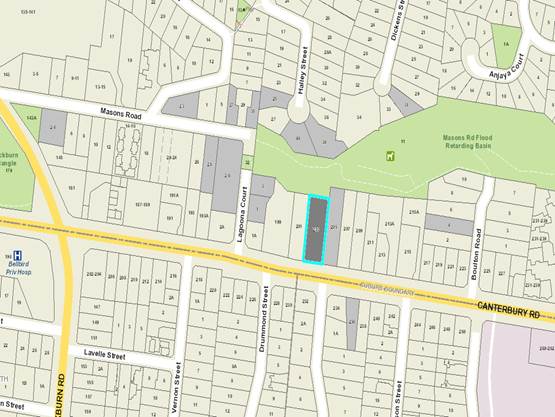
Subject site
|
|
15 Objector Properties
(9
outside of map)
|
é
North
|
BACKGROUND
History
Two (2) previous planning permit
applications have been lodged and subsequently approved by Council in relation
to the subject site (the site) and are summarised below:
· WH/2008/212
proposed the removal of eight (8) protected trees and lopping of three (3)
protected trees on the site and was approved subject to conditions in August
2008.
· WH/2009/470
proposed the erection of advertising signage on the site in association with
use of land for the purpose of home occupation and was approved subject to
conditions in October 2009.
The Site and Surrounds
The subject site is located on the
north side of Canterbury Road in Blackburn, approximately 320 metres east of
the intersection with Blackburn Road and 1.1 kilometres west of intersection
with Springvale Road. The Forest Hill Chase Shopping Centre is located on
Canterbury Road, approximately 250 metres to the east of the site.
The site has a total site area of
1845 square metres with a frontage of 25.91 metres to Canterbury Road and a
maximum depth of 71.27 metres. It contains a slope of over four (4) metres from
the south to north and is not encumbered by any easements on site.
The site currently contains a
detached single storey brick dwelling with tile pitched roofing, located
centrally within the site. There are also a number of well-established canopy
trees located on the site; with the majority of these located within the front
setback.
The Masons Road Flood Retarding
Basin adjoins the site to the immediate north (rear) comprising a significant
open space area running from Lagoona Court in the west to Forest Road in the
east. The Masons Road Flood Retarding Basin is contains a number of
indigenous plant species and canopy trees.
The surrounding properties are
residential containing a mix of single and double storey dwellings set on large
lots with the majority of these containing relatively substantive canopy
trees/canopy coverage. A number of canopy trees are located on adjoining
residential properties. Most notably there is a well-established Eucalyptus
cladocalyx – Sugar Gum located within the south-western quadrant of
No. 205 Canterbury Road, Blackburn adjoining common boundary fencing with the
site, and a well-established Eucalyptus sideroxylon – Ironbark
located within the south-eastern quadrant of No. 201 Canterbury Road, Blackburn
adjoining common boundary fencing with the site.
Planning Controls
The proposal triggers the need for
a planning permit under the following clauses contained within the Whitehorse
Planning Scheme:
Neighbourhood
Residential Zone, Schedule 1 (Clause 32.09)
Pursuant to Clause 32.09-6 of the
Whitehorse Planning Scheme; a permit is required to construct two or more
dwellings on a lot.
Pursuant to Clause 32.09-9 of the
Whitehorse Planning Scheme, a building must not exceed 9 metres maximum
building height unless the slope of natural ground level measured at any cross
section of the site of the building wider than 8 metres, is greater than 2.5
degrees.
The site contains a slope of over
4% and thus the building may exceed the maximum building height by up to 1
metre.
Significant
Landscape Overlay (Clause 42.03)
Pursuant to Clause 42.03-2 of the
Whitehorse Planning Scheme; a permit is required to remove, destroy or lop a
tree and to construct a building or construct or carry out works.
Access
to a Road Zone, Category 1 (Clause 52.29)
Pursuant to Clause 52.29 of the
Whitehorse Planning Scheme; a permit is required to create or alter access to a
road in a Road Zone, Category1.
State Planning Policy
Clause 11
Clause 11 (Settlement) states than
planning is to ‘anticipate and respond to the needs of existing and
future communities’, recognise the need for ‘diversity of
choice, economic viability, a high standard of urban design and amenity and
protection of environmentally sensitive areas and natural resources’
and to promote the ‘sustainable growth and development of Victoria (whilst)
deliver(ing) choice and opportunity for all Victorians through a network
of settlements’.
Clause 12
Clause 12 (Environmental and
Landscape Values) identifies that ‘planning should help protect the
health of ecological systems and the biodiversity they support (including
ecosystems, habitats, species and genetic diversity) and conserve areas with
identified environmental and landscape values’ and that it should
seek to ‘avoid the removal, destruction or lopping of native
vegetation or minimise impacts from the removal, destruction or lopping of
native vegetation that cannot be avoided’.
Clause 15
Clause 15 (Built Environment and
Heritage) notes that ‘planning should ensure all new land use and
development appropriately responds to its landscape, valued built form and
cultural context’ and planning should achieve high quality urban
design and architecture that:
· Contributes
positively to local urban character and sense of place.
· Reflects
the particular characteristics, and cultural identity of the community.
· Enhances
the function, amenity and safety of the public realm.
Clause 16
Clause 16 (Housing) identifies that
‘planning should provide for housing diversity, and ensure the
efficient provision of supporting infrastructure’ by encouraging
‘increase the supply of housing in existing urban areas by
facilitating increased housing yield in appropriate locations, including
under-utilised urban land’ to be achieved through ‘locat(ing)
new housing in or close to activity centres and in urban renewal precincts and
sites that offer good access to jobs, services and transport’.
Local Planning Policy
Clause 21.05
Clause 21.05 (Environment)
identifies that there are ‘issues of natural environment, visual
environment and the built environment which are important to the City of
Whitehorse’ and that ‘several areas in the City have special
natural, environmental or historic significance’, noting that ‘these
areas are not merely places for recreation, but conservation’.
Relevant key objectives and strategies to achieve this include:
· Ensuring
that the replanting of tall trees and indigenous vegetation is appropriate to
the type of vegetation in the area and enhances and retains biodiversity.
· Encouraging
appropriate development that responds to environmental characteristics and infrastructure
constraints.
· Ensuring
development is of a high quality design that is compatible with the character
and appearance of the area.
· Providing
adequate open space and landscaping for new development.
Clause 21.06
Clause 21.06 (Housing) identifies
and acknowledges that The City of Whitehorse is a ‘middle ring
municipality providing housing for a wide range of household types, ages and
cultural groups’ and that it is ‘under increased pressure to
accommodate more people who are attracted to the area due to its strategic
location, high amenity residential areas and quality services and facilities’.
The Council seeks to accommodate and facilitate this change through its Housing
Strategy 2014 and Neighbourhood Character Study 2014; which identify
various neighbourhood character areas (Bush Environment, Bush Suburban and
Garden Suburban) and areas appropriate for substantial, natural and limited
change.
Clause 22.03
Clause 22.03 (Residential
Development) seeks to ensure that residential development within the City of
Whitehorse is consistent with the built form envisaged for the three categories
of housing change and that it contributes to the preferred neighbourhood
character of the area, whilst not detracting from the natural environment and
ecological systems.
Clause 22.04
Clause 22.04 (Tree Conservation)
identifies and acknowledges the importance of tree conservation within the City
of Whitehorse and sets out a number of policy and performance standards
relating to the retention and tree regeneration when undertaking development.
Clause 55 Two or Dwellings on a
Lot
Clause 55, generally referred to as
ResCode is a series of standards and performance objectives designed to guide
the development of land for two or more dwellings.
PROPOSAL
The proposal seeks approval for the
Construction of Four (4) Double Storey Dwellings, Removal of Vegetation and
Alteration of Access to a Road Zone, Category 1.
In summary, the proposal includes
the following:
· Development
of four (4) double storey dwellings in a ‘tandem’ layout and
attached in two groupings of two, with Dwellings 1 and 2 to be attached and
Dwellings 3 and 4 to be attached and accessible via a single driveway located
along the sites eastern boundary.
· Dwellings
1 and 2 are mirrored in nature with both containing a double width garage,
bedroom with ensuite and living/dining/kitchen area at ground floor level and
three bedrooms and living area at first floor level.
· Dwellings
2 and 3 are also designed so as to contain a double width garage, bedroom with
ensuite and living/dining/kitchen area at ground floor level and three bedrooms
and living area at first floor level.
· A
new double width crossover accessing onto Canterbury Road, located in the sites
south-eastern boundary.
· Removal
of three trees protected under SLO2 (trees numbered 1, 5 and 6) and removal of
twenty-one (21) trees/shrubs not protected under SLO2. A summary table of
protected trees under SLO2 is provided below:
|
|
Botanical Name
|
Common Name
|
Height (m)
|
Age (year)
|
Health/
Structure
|
|
Tree 1
|
Eucalyptus botriodes
|
Mahogany Gum
|
14m
|
30-45
|
Poor Health/Poor Structure
|
|
Tree 5
|
Eucalyptus calophylla
|
Marri
|
7m
|
15-25
|
Good Health/Poor Structure
|
|
Tree 6
|
Eucalyptus botriodes
|
Mahogany Gum
|
8m
|
8-12
|
Poor Health/Poor Structure
|
· Retention
of seven (7) trees currently located on site and protected under SL02 (trees 2,
3, 4, 8, 9, 10 and 15). A summary table of is provided below:
|
|
Botanical Name
|
Common Name
|
Height (m)
|
Age (year)
|
Health/
Structure
|
|
Tree 2
|
Grevillea robusta
|
Silky Oak
|
10m
|
15-25
|
Good Health/Poor Structure
|
|
Tree 3
|
Eucalyptus calophylla
|
Marri
|
5m
|
8-12
|
Good Health/Good Structure
|
|
Tree 4
|
Allocasuarina torulosa
|
Forest Oak
|
7m
|
10-20
|
Good Health/Poor Structure
|
|
Tree 8
|
Eucalyptus sideroxylon
|
Ironbark
|
9m
|
15-25
|
Good Health/Structure
|
|
Tree 9
|
Lophostemon confertus
|
Queensland Brush Box
|
9m
|
15-25
|
Good Health/Structure
|
|
Tree 10
|
Eucalytpus camaldulensis
|
Red Gum
|
14m
|
25-40
|
Good Health/Poor Structure
|
|
Tree 15
|
Eucalytpus melliodora
|
Yellow Box
|
6m
|
8-12
|
Good Health/Structure
|
· Replacement
planting of twenty-seven (27) trees with a height at maturity of 6 metres,
thirteen (13) trees with a height at maturity of 10 metres and four (4) trees
with a height at maturity of 15 metres.
In addition to the summary above, the proposal also
provides:
· A
minimum street front setback to Canterbury Road of 8.9 metres.
· Minimum
side setbacks from the sites eastern boundary of 4.275 metres (exception being
Dwelling 4 Garage wall which is setback 1.36 metres from boundary).
· Minimum
side setbacks from the sites western boundary of 4.9 metres.
· Minimum
rear setbacks from the sites rear (northern) boundary of 5.510 metres.
· Maximum
total site coverage of 37%.
· Site
permeability of 58%.
· Garden
Area percentage of 47%
· A
maximum build height for Dwellings 1 and 2 of 9.96 metres above natural ground
level.
· A
maximum building height for Dwellings 3 and 4 of 9.95 metres above natural
ground level.
CONSULTATION
Public Notice
The original application was
advertised by mail to the adjacent and nearby property owners and occupiers and
by erecting notices to the Canterbury Road frontage. Following the
advertising period twenty-four (24) objections were received.
The issues raised are summarised as
follows:
Neighbourhood Character
· Appropriateness
of development of four double storey dwellings in the area
· Overdevelopment
of site
· Bulk
and Massing
Traffic and Car Parking
· Traffic
Impacts along Canterbury Road
· Concerns
regarding Visitor Parking
· Pedestrian
and Driver Safety
Vegetation Removal
· Fauna
Impacts
· Neighbourhood
Character Impacts
· Non-compliance
with the relevant Significant Landscape Overlay and Bush Environment Precinct
Guidelines.
· Amenity
Impacts
Amenity impacts
· Visual
Bulk
· Vegetation
Removal
· Overlooking
· Overshadowing
· Noise
· Traffic
Consultation Forum
A Consultation Forum was held on 5th
June 2018. Approximately sixteen (16) objectors attended the meeting, in
addition to Cr Massoud, planning officers and the applicant.
The Consultation Forum was chaired
by Councillor Massoud and concerns/objections with the proposal were grouped
under broad categories with all parties afforded the opportunity to provide
commentary on each concern. The permit applicant was also given an opportunity
to respond to objector concerns. A number of potential resolutions were
discussed between parties however no resolution was reached between the
parties.
Section 57A amendment
Subsequent to the advertising
period and Consultation Forum amended plans were submitted via section 57A of
the Planning and Environment Act 1987 seeking to
address issues raised by referrals and objections raised where possible. The
key changes include:
· Removal
of east and west facing balconies above garages of Dwellings 3 and 4.
· Relocation
of Dwelling 4 Garage wall from boundary; to be setback 1.36 metres from eastern
boundary
· Relocation
of Dwelling 3 Garage to allow for increased areas of landscaping and tree
planting envelopes
· Revised
landscape plan, providing for reduction in hard surfacing, increased provision
of canopy trees, increased areas of landscaping and expansion of tree planting
envelopes.
These plans were not readvertised
as they are not considered to result in additional detriment to adjoining
owners and/or occupiers.
Referrals
External
VicRoads
Pursuant to section 55 of the Planning
and Environment Act 1987, the proposal was referred to VicRoads who did not
object to the proposal subject to conditions relating to the proposed crossover
and vehicular access to and from the site.
Internal
Engineering and Environmental
Services Department
· Transport
Engineer
The application was referred to Council’s Transport
Engineering team who have reviewed the proposal and do not object to the
proposal, subject to recommended conditions relating to vehicular access both
to and throughout the site.
· Waste
Engineer
The application was referred to Council’s Waste
Engineering team who have reviewed the proposal and do not object to the
proposal, subject to recommended waste management conditions.
· Assets
Engineer
The application was referred to
Council’s Asset Engineering team who have reviewed the proposal and do
not object to the proposal, subject to standard conditions.
Planning Arborist
The application was referred to
Council’s Planning Arborist who has reviewed the proposal and does not
object to the proposal subject to standard conditions relating to protection
and retention of canopy trees both on site and within adjoining properties.
DISCUSSION
Planning Scheme
State Planning Policy
The construction of four dwellings
on site is consistent with State Planning Policies, which encourage higher
density development within walking distance of shops, recreation facilities and
public transport. The proposal accords with State Planning Policies which
seek to ensure housing stock matches changing demand by widening housing
choice; encourage the development of well-designed medium-density housing that
makes better use of existing infrastructure; and that new development respects
the neighbourhood character and appropriately responds to its landscape, valued
built form and cultural context.
Local Planning
Policy
Local planning policy at Clause
21.05 (Environment) identifies issues of natural, visual and built environment.
Clause 21.06 acknowledges that The City of Whitehorse is a ‘middle
ring municipality providing housing for a wide range of household types, ages
and cultural groups’ and that it is ‘under increased
pressure to accommodate more people who are attracted to the area due to its
strategic location, high amenity residential areas and quality services and
facilities’.
The Council seeks to accommodate
and facilitate this change through its Housing Strategy 2014 and Neighbourhood
Character Study 2014; which identify various neighbourhood character areas
(Bush Environment, Bush Suburban and Garden Suburban) and areas appropriate for
substantial, natural and limited change.
The subject site is located within
a Bush Environment/Limited Change Area. This requires any design response to
respond to the surrounding low scale and detached or semi-detached dwelling
form, whilst recognising key environmental and heritage attributes evident.
The proposal responds to these
policy objectives in that it provides for four semi-detached dwellings,
arranged in two lots of two attached buildings, designed to reflect the scale
and size of dwellings that otherwise define the neighbourhood character. This
design provides effective use of the site and conserves and enhances
landscaping opportunities, retention of significant trees and vegetation,
whilst providing space for planting of new canopy trees, a key character and
landscape element of the area.
Specifically, the importance of the
landscape setting and important environmental context is achieved through
retention of seven (7) well-established canopy trees on-site and provision of
an additional forty-four (44) trees throughout the site (via new landscaping),
thirteen of which have a minimum height at maturity of 10 metres and four (4)
of which have a minimum height at maturity of 15 metres.
It is additionally noted that the
proposal provides for new development on the site which reflects an appropriate
response to both the preferred and existing neighbourhood character as it seeks
to provide for substantive setbacks from all side and rear boundaries,
concentrates the building footprint centrally within the site allowing for the
provision of generous landscaping and retention of view lines between
buildings/built form.
Neighbourhood Residential Zone
– Schedule 1 (Bush Environment Areas)
The purpose of the Neighbourhood
Residential Zone is to:
· To
implement the State Planning Policy Framework and the Local Planning Policy
Framework, including the Municipal Strategic Statement and local planning
policies.
· To
recognise areas of predominantly single and double storey residential
development.
· To
manage and ensure that development respects the identified neighbourhood
character, heritage, environmental or landscape characteristics.
· To
allow educational, recreational, religious, community and a limited range of
other non-residential uses to serve local community needs in appropriate
locations.
The proposal is considered to be
consistent with the intent and purpose of the Neighbourhood Residential Zone.
It achieves this by consolidating development on an underutilised and
strategically located site in a semi-attached double storey built form. It
achieves compliance with all varied ResCode (Clause 55) Standards of NRZ1 and
does not exceed the maximum height limit of 10 metres which is mandatory under
the NRZ.
Significant Landscape Overlay
– Schedule 2 (SLO2)
The Significant Landscape Overlay
is recognised as an important part of the Whitehorse Planning Scheme, and as
such considerable weight is placed upon an application’s ability to meet
the objectives and decision guidelines. The presence of the SLO does not negate
the ability of a site to be developed for residential purposes, however the
hierarchy of the SLO control does require a more sensitive approach and places
higher levels of expectation on how a site is to respond to built-form,
landscape and environmental values.
SLO2 identifies the site as being
located within ‘Blackburn Area 2’ whereby the following statement
of significance is outlined below:
‘The significance of the
area is attributed to the quality of the environment, which includes vegetation
notable for its height, density, maturity and high proportion of Australian
native trees.
This in turn contributes to the
significance of the area as a valuable bird and wildlife habitat’.
A number of key decision guidelines must be considered and are
summarised below:
· The
proposed developments ability to provide for appropriate landscaping
opportunity.
· The
proposed developments siting and design, so as to provide for a subservient
profile within the context of the site.
· The
proposed developments impact on existing vegetation on site and surrounding
properties.
In review of the above, it is
considered that the proposed development is setback a reasonable distance from
property boundaries to provide for a well-conceived landscape design throughout
the site, which both ensures adequate retention of existing vegetation and
enhances existing landscaping throughout the site.
The total site area is 1845sqm, of
which 37% is proposed to be taken up by buildings and works and 58% is to be
permeable. This 58% of permeable land is largely provided in the form of
private open space and secluded private open space throughout the development.
All areas of secluded private open space, are to be located along the
site’s side and rear boundaries and exceed 50sqm.
The proposal seeks to retain seven
(7) of ten (10) trees identified as protected under the SLO2, a retention rate
of 70%. The three (3) trees which are sought to be removed under the
application are of poor health or structure.
Trees 1, 5 and 6 which are proposed
for removal, whilst identified as native species and of substantial age and
stature, are in poor health and structure and thus removal, coupled with
appropriate replacement planting is considered the best outcome for the site,
particularly having a medium to long term view of planting of the site over
time.
Council’s Arborist has
undertaken an inspection of the site and reviewed the proposed development and
accompanying Arborist Report and does not dispute the proposed removal of these
trees.
The application seeks to provide
for replacement planting of a total of four (4) canopy trees capable of
reaching a height at maturity of over 15 metres plus the retention of an
additional seven (7) trees (Trees 2, 3, 4, 8, 9, 10 and 15) which are capable
of reaching a height of over 15 metres; resulting in a total of ten (10)
capable of reaching a height of over 15 metres on site.
The decision guidelines for SLO2
aim to provide for twelve (12) trees on site, capable of reaching a height of
over 15 metres. As the proposal is only able to provide for a total of ten (10)
trees capable of reaching a height of over 15 metres, a condition will be
placed on any permit issued requiring an additional two (2) canopy trees
capable of reaching a height of over 15 metres be provided on site. This will
be achieved in conjunction with a permit condition requiring reduction in
extent of paving within secluded private open space areas of Dwellings 3 and 4
so as to allow for additional areas for landscaping and canopy tree growth.
Regarding trees on adjoining sites,
Council’s Arborist notes that retention and protection of all trees on
adjoining properties is viable, subject to conditions requiring vehicular
access to be constructed at grade and that no soil level changes are to occur
within relative proximity of trees 7 and 8. These tree protection requirements
have been discussed with all other departments of Council who have acknowledged
the requirements and identified them as viable.
Additionally it is noted the
proposal has also been reviewed by Council’s Assets team who have
required conditions be placed on any permit issued to appropriately manage
stormwater on site and runoff to surrounding properties.
Landscaping
The proposed development seeks to
provide for an additional forty-four (44) trees throughout the site, detailed
below:
· Twenty-seven
(27) trees with a height at maturity of 6 metres;
· Thirteen
(13) trees with a height at maturity of 10 metres; and
· Four
(4) trees with a height at maturity of 15 metres.
The proposed replanting and overall
provision of landscaping throughout the site, coupled with proposed retention
of existing canopy trees, is considered to provide for an optimal landscaping
outcome, one which enhances vegetation and landscaping on site whilst allowing
for an appropriate transition between existing and new canopy tree growth
throughout site and will ensure an appropriately landscaped outcome on site
throughout the life of the development.
It is noted however the proposal
does not meet decision guidelines of SLO2 which seeks the provision of one (1)
canopy tree capable of reaching a maximum height of 15 metres at maturity per
150sqm of site as discussed above. The subject site however, has the
opportunity to comply with this guideline and as such a condition will be
placed on any issued permit to achieve this.
Additionally, whilst it is noted
that the proposal does not strictly comply with performance standards of Clause
22.04 which seek to provide for a minimum area of 50sqm of open ground within
minimum dimensions of five metres that is free of buildings for new plantings,
it is submitted that a condition on permit requires these areas be provided for
replacement plantings and where not achieved for the remainder of proposed
landscaping adequate areas for future growth and development have been
provided.
Neighbourhood Character and
Built Form
Neighbourhood Character
The site is located in a Bush
Environment Neighbourhood Character area pursuant to the City of Whitehorse
Neighbourhood Character Study 2014, and is designated as ‘limited
change’. Specifically, the policy states:
This precinct is identified for
the lowest scale of intended residential growth in Whitehorse (Limited Change
area) and the preservation of its significant landscape character and
environmental integrity is the highest priority.
It is submitted that the proposed
development adequately responds to both the existing and preferred character
statement as it seeks to provide for semi-detached residential dwellings which
do not exceed two storeys in height.
The use of predominantly brick and
timber materials, coupled with generous setbacks from all boundaries, ensures
that the proposed design response does not dominate the streetscape and
provides for retention of existing vegetation on site and substantial
landscaping opportunities throughout. It is noted however that whilst the use
of predominantly brick and timber is supported and considered to appropriately
respond to the both existing and preferred neighbourhood character, that the
use of metal cladding in a dark matt finish is considered inconsistent with
this character. As such a condition is to be placed on permit requiring that
the proposed metal cladding be amended in colour so as to provide for a more
muted colour of ‘earthy tone’ consistent with the bush environment
character of the area.
The retention of trees 2, 3 and 4
along with provision of additional three (3) trees within the site’s
frontage is considered to adequately ensure the proposed development will not
appear dominant to and be well screened from the street frontage throughout its
lifetime, with this to be further enhanced with landscape planting along both side
boundaries of the site.
The provision of a 1.8 metre high
timber batten privacy screen fence along the site’s Canterbury Road
frontage, whilst acknowledged as generally inconsistent with both existing and
preferred neighbourhood character of the Bush Environment Character Precinct,
is submitted to be relatively unobtrusive in nature given its materiality
(timber batten) and design (containing of 250mm spacing between battens).
Built Form
The tandem and attached nature of
the proposed design will present as two double storey dwellings when viewed
from street frontage and adjoining properties.
The development has been designed
in accordance with all varied ResCode (Clause 55) Standards of NRZ1 allowing
for substantial landscaping opportunities within the front, side and rear
setbacks of site, with minimum setbacks of 8.9 metres (front), 4.9 metres
(side) and 5.5 metres (rear) respectively. Additionally the proposal complies
with maximum building height of 10 metres within the NRZ and provides for large
private open space areas for all dwellings, with all dwellings exceeding 50sqm
with a minimum width of 5 metres and to be located along side and rear
boundaries.
Primary concerns associated with
the proposal largely related to the location of the Dwelling 4 garage wall on
the boundary and provision/location of balconies at upper levels, particularly
those of Dwelling 3 and 4. It is noted that these concerns were resolved
following receipt of the amended plans which sought to relocate the Dwelling 4
garage wall off the eastern (side) boundary and remove east and west facing
balconies of Dwellings 3 and 4. Whilst the proposal continues to seek to
provide for balconies at upper levels to all dwellings, it is submitted that
these balconies (particularly those of Dwellings 1 and 2) are part of the
architectural design and provide for an appropriate level of articulation to
the proposed development.
Car Parking
The proposal meets the requirements
of Clause 52.06 (Car parking) and, as noted above, the Council Transport
Engineering Department supports the proposal subject to conditions relating to
vehicular access both to and throughout the site.
Additionally it is noted, that
Council have received objections against the non-provision of a visitor
car-parking space and concerns regarding pedestrian/driver safety. It is noted
that pursuant to Clause 52.06 the provision of a visitor parking space is not
required and that the provision of a double width crossover and passing bay
couple with site line triangles as required by Clause 52.06 is consistent with
planning policy regarding these matters.
Objectors Concerns not
Previously Addressed
At the Consultation Forum objector
concerns were able to be further explored and elaborated upon. The following
seeks to address those concerns which may not have been adequately addressed or
discussed above.
Amenity Impacts
Concerns have been raised by
objecting parties regarding potential amenity impact, particularly those of
overlooking, overshadowing and noise.
The proposal has been assessed
against relevant ResCode Standards B21 (Overshadowing), Standard B22
(Overlooking) and Standard B24 (Noise Impacts) and is compliant with these
requirements.
Proposed Crossover/Driveway
Concerns have been raised by
objecting parties regarding the proposed crossover and driveway, particularly
regarding its impact on tree 7 located on adjoining property to the east and
the ongoing viability of the proposed permeable surfacing. It is noted that the
proposal has been reviewed by Council’s Arborist who has raised no
objection to the proposed surfacing and that a condition ensuring ongoing
protection and maintenance of the proposed permeable surface is to be placed on
any permit issued.
Masons Road Retarding Basin
Concerns have been raised regarding
the Masons Road Retarding Basin, particularly regarding the proposal’s
impact on vegetation and its visual impact within the reserve.
Council’s Arborist has raised
no concern with respect to the proposal’s impact upon canopy trees
located within the reserve and that the proposal provides for appropriate
setbacks, from and landscaping opportunities along the rear boundary so as to
ensure the proposal does not dominate the landscape.
Additionally it is noted concerns
regarding vistas to the site were raised along with a request for cyclone
fencing to be provided along the site’s northern boundary. As noted
above, the proposal is considered to be set back adequate distance from the
rear boundary and provided with adequate landscaping opportunities for screen
planting whilst the provision of fencing on the rear boundary does not require
planning permission.
Viability/Appropriateness of
Landscaping
Concerns have been raised regarding
the viability and appropriateness of proposed landscaping throughout the site,
particularly regarding provision of underground water tanks and replacement
planting species.
It is
noted a condition will be placed on any permit requiring all water tanks to be
provided to respective Dwellings must be above ground tanks in a location
acceptable to the responsible authority to ensure there is appropriate deep
soil planting opportunities available throughout the site. In respect to
replacement planting of canopy trees, it is noted a condition is to be placed
on any permit requiring all species to be indigenous varietal.
CONCLUSION
The proposed development is
consistent with the relevant planning controls and policies, including the
State and Local Planning Policies and provisions of the NRZ1and the SLO2. The
proposed development form, siting and overall design is considered to be acceptable
and will integrate well with the existing built form and character whilst
providing for an acceptable landscaping outcome which retains a number of
well-established canopy trees and provide for adequate replacement planting
opportunities throughout the site.
A total of twenty-four (24)
objections were received as a result of public notice and all of the issues
raised in these objections have been discussed in this report.
It is considered that the
application should be approved subject to conditions.
Attachment
1 Development
Plans ⇨ 
2 Landscape
Package ⇨
9.1.2 Student
Accommodation Policy Review
FILE NUMBER: SF17/824
ATTACHMENT
SUMMARY
This report
provides Council with the findings of the Student Accommodation Review 2018 and
presents a Student Accommodation Strategy for the City of Whitehorse. The
Strategy recommends broad actions to ensure that students in Whitehorse have
access to safe and legal accommodation and to minimise off-site amenity impacts
to the surrounding area.
The Strategy
addresses the findings of the consultation process which included a survey of
tertiary students and other residents with an interest in student accommodation
in Whitehorse, engagement with key stakeholders as well as transport and
traffic surveys and analysis. The Strategy is supported by a Background Report
which provides an exploration of many issues related to the provision of
student accommodation. The issues addressed in the Review are diverse and
sometimes reach beyond the control of the Planning Scheme.
This report
recommends that the Student Accommodation Strategy be adopted by Council and
that Council seeks authorisation from the Minister for Planning to prepare and
exhibit a planning scheme amendment. This amendment would seek to introduce a
revised Student Accommodation Policy at Clause 22.14 and include the Student
Accommodation Strategy and Background Paper as reference documents in the Whitehorse
Planning Scheme.
|
RECOMMENDATION
That Council:
1. Note the City of Whitehorse Student
Accommodation Strategy - Background Paper, July 2018.
2. Adopt the City of Whitehorse Student
Accommodation Strategy, July 2018.
3. Seek
authorisation from the Minister for Planning to prepare and exhibit an
amendment to the Whitehorse Planning Scheme to introduce a revised Student
Accommodation Policy at Clause 22.14 of the Whitehorse Planning Scheme.
|
background
The first
Whitehorse Student Accommodation Study was done in 2006. The study explored a
range of issues including:
· Current
and future housing needs and provision;
· Design
and amenity;
· Traffic
and car parking;
· Access;
and
· Private
and communal open space.
Documents produced
as part of this project informed the development of a Local Planning
Policy and in June 2009 Amendment C87 was gazetted to introduce a Student
Accommodation Policy at Clause 22.14 of the Whitehorse Planning Scheme.
This policy applies to all planning permit applications for purpose built
student accommodation in the municipality.
Over time, problems including
parking congestion, dumped rubbish and unsightly residential premises have been
reported to Council and are alleged to be attributed to the student
population. Under its various legislative responsibilities, Council has
also responded to instances of illegal and substandard accommodation used to
house students. This has raised concerns about the welfare of our student
population and triggered the need to explore opportunities for Council to
influence improved student housing outcomes.
After using the existing policy for
nearly 10 years and in light of the growth in the municipality’s student
population, it is now considered necessary to review the current local policy
in the planning scheme and undertake a wider investigation of issues perceived
to be associated with accommodation of students in Whitehorse.
Overview of student demographics
A review of student accommodation
in Whitehorse has been undertaken and a Background Paper and Strategy have been
produced. These documents include and address issues identified throughout the
research, analysis and consultation process. The Background Paper and Student
Accommodation Strategy are available in Attachments 1 and 2 and are
discussed further in the ‘Discussion’ section of this report.
The Victorian student population is
growing overall and is a major export driver in the Victorian economy. In 2016,
the sector generated $7.1 billion in export revenue for the State and supported
over 30,000 Victorian jobs[1].
The municipality captures a proportion of this due to the presence of two key
tertiary institutions;
· Box
Hill Institute (approximately 37,000 students in 2018); and
· Deakin
University (approximately 28,000 students in 2018).
The student population has grown
from 17,159 tertiary students living in the municipality in 2011, to 18,284
students in 2016. This represents a total of 1.3% growth per annum. Student
growth is slightly stronger than population growth in Whitehorse, although the
difference is marginal. Students accounted for 10.9% of the Whitehorse
population in 2016, and are projected to be 12% by 2051.
The economic contribution of students in the municipality is
as follows:
· Domestic
students (who would otherwise live somewhere in Melbourne regardless)
contribute approximately $173m per annum based on student consumer spending;
and
· International
students (new expenditure) contribute approximately $77m per annum based on
student consumer spending
This comprises
retail spending, hospitality, retail services and non-retail spending.
At the same time the City of
Whitehorse is growing; Box Hill in particular is a hub for higher density
residential development. Housing in Whitehorse is becoming less affordable,
which has implications for a range of groups, including students. While many
local students continue to live in the family home, there are still a number of
local and international students residing in Whitehorse who have a range of
housing needs.
DISCUSSION
Current student accommodation
types
Students live in a range of accommodation
types which can be categorised according to typology based on the extent of
their management. This ranges from on-campus residential colleges which are
strictly managed, to informal and unmanaged housing on the open market. These
different types of accommodation also include variations in location, design,
quality, provision of facilities and built-form outcomes.
TABLE 1: CURRENT DISTRIBUTION OF STUDENT
ACCOMMODATION
|
|
Accommodation Type
|
Accommodation Features
|
Capacity/Count
|
|
1
|
On campus
|
Larger buildings
located on university campus.
|
1,175 beds
|
|
2
|
Purpose built
|
Apartment style,
usually smaller than on-campus. Typically between 2 and 4 storeys.
|
663 beds
|
|
3
|
Rooming houses
|
Often adapted from
older houses. Residents have shared access to communal facilities –
lounge, kitchen and bathroom.
|
Up to 1,800 persons
|
|
4
|
Open market housing
|
Standalone houses,
apartments, townhouses. Available to students and non-students.
|
14,038 resident
students
|
|
5
|
Informal housing
|
Garages or other
structures converted to living quarters. May share facilities with the main
dwelling on the lot.
|
Unable to estimate
(illegal housing)
|
An estimation of the distribution
of students across these accommodation types is provided in Table 1, with the
vast majority of students living in open market housing. It is noted that
potential informal/illegal housing is difficult to quantify, as once
identified, enforcement action is pursued. In addition, students may also
occupy hotels, motels and serviced apartments for a period of time, however
estimates of students occupying these forms of accommodation are unable to be
determined and therefore have not been included in Table 1.
Perceived issues
with student accommodation are generally associated with open market housing,
rather than the more ‘managed’ student accommodation. Although
amenity and parking issues cannot be attributed only to students,
‘unmanaged’ student housing typologies face problems when they are
overcrowded or poorly regulated, including:
· Car
parking demand which cannot be accommodated on site, which is not only a
problem at rental accommodation but also at the family home as students stay at
home longer.
· Dumped
furniture and household items at the end of tenancy.
· Poor
internal amenity for students – limited facilities, shared lounge,
kitchen and bathroom.
· Open
market housing affordability – supply issues where students (short term)
and non-students (long term) compete for housing in the same market.
The legislative
and governance environment for these issues is complex, and Council has a
number of roles to play. The current governance and regulatory framework within
the City of Whitehorse (and that applies to most other municipalities) means
that student accommodation is not assessed consistently. The issues are:
· Most
importantly, accommodation used by students does not require a planning permit
for use as ‘student accommodation’.
· Student
accommodation is an innominate (unlisted) term in the planning scheme. This
means that the local planning policy ‘Student Accommodation’
(Clause 22.14) only applies where the developer has identified they are
providing student accommodation. All other accommodation which may be used by
students does not need to be assessed against the policy.
· Most
accommodation providing less than eleven bedrooms does not require a planning
permit for the use as it is defined as ‘shared housing’ under the
state section of the planning scheme.
· The
planning scheme definition for shared housing (ten or less habitable rooms)
differs subtly from the Building Regulations definition (twelve or less
residents) and the Health Regulations definition for prescribed accommodation
(six or more residents).
These factors mean
that it is difficult for Council to manage student housing consistently across
the municipality. Rather than being assessed based on accommodation type
(student accommodation), development is assessed based on the size of the
facility and according to how the applicant has chosen to define the
development. This means that policies relating to the following aspects cannot
be consistently applied:
· Location;
· Provision
for adequacy of communal facilities;
· Requirements
for a site management plan;
· Support
for student welfare; and
· Dispensations
for car parking, storage and open space.
This governance
environment also means that Council has no way of fully identifying
accommodation that is being used for student housing across the municipality.
Map 1 below shows
the distribution of different student accommodation types across the
municipality. As expected there is a conglomeration of residential colleges
around Deakin University. Purpose built student accommodation facilities are
generally located close to Box Hill Institute and Deakin University with some
more dispersed purpose built facilities. Open market housing is dispersed
across the municipality with more students tending to occupy those residences
closer to tertiary institutions.
MAP 1: CURRENT DISTRIBUTION OF STUDENT
ACCOMMODATION BY TYPE
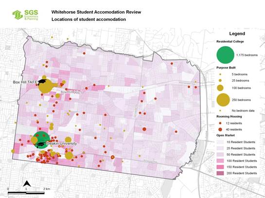
Building design
Student
accommodation is typified by relatively high turnover of residents (due to the
short term studies) many of whom may have limited connection to the local
community due to their international status. The design of student
accommodation needs to take into account these issues by providing spaces that
deliver internal amenity and a sense of community for students.
The key
differences between student housing and other forms of housing is the
acceptance of a reduction in the size of individual private spaces (compared to
ordinary housing) to aid affordability and the short term nature of the
occupancy. Student housing is designed with the expectation that students will
only stay for the duration of their course and will spend a large proportion of
their day outside of the accommodation, using the facilities of the educational
institution, working or using external entertainment or recreation
opportunities.
The size of
individual bedroom units will potentially differ depending on the type of
accommodation on offer. In all cases the space should be large enough for a
bed, a desk and an area for dressing and storage of clothing and personal
belongings. It is possible to deliver smaller floor areas (potentially
11-12sqm) where all furniture is built in. Where the room is partially
furnished or unfurnished it will be necessary to increase the room size
(greater 16sqm) to allow for more generic furniture sizes. Limited internal
amenity within smaller dwelling units can be offset by increased opportunities for
shared communal facilities that meet the needs of students.
Rooming houses and ordinary
residential dwellings adapted for student accommodation often deliver poorer
quality shared facilities, particularly where large numbers of residents share
the same facilities. This reduces the useability, functionality and amenity of
this housing type for students. There is limited opportunity to influence the
outcomes of these adaptations as a planning permit is not always required.
Revisions to the Student Accommodation Policy at Clause 22.14
of the Whitehorse Planning Scheme could encourage and incentivise the delivery
of higher quality managed student accommodation types in preferred locations
and may help reduce the risk of poor quality housing causing issues for the
wider community.
|
Building Design Recommendations:
|
|
· Revise the Student Accommodation Policy
at Clause 22.14 of the Whitehorse Planning Scheme to further promote high
quality design of student accommodation located in close proximity to the
tertiary institutions and public transport and to respond to issues
identified in the Review. The draft updated policy is shown in
Attachment 3.
|
Surveys and
stakeholder engagement
Primary research
through questionnaires (face-to-face and online), traffic data collection and
contact with key stakeholders has been a vital component of the Review.
Workshops with
Council staff were held on 19 March and 24 April 2018 and were attended by
representatives from Strategic Planning, Statutory Planning, Environmental
Health, Transport, Building, Community Laws, Investment and Economic
Development and Community Development. These workshops helped to develop an
understanding of the legislative framework surrounding Student Accommodation
and some of the potential responses and management options regarding specific
situations.
Telephone
interviews and face to face meetings with a number of external stakeholders
provided a greater understanding of the nature and scale of issues associated
with student accommodation, including welfare officers from Deakin University
and Box Hill Institute, Deakin University Legal Service, Eastern Community
Legal Centre and student housing providers such as Student Housing Australia.
Posts were added to the tertiary institution’s Facebook pages to draw
student’s attention to the Review. Meetings with these stakeholders also
provided the opportunity to build relationships with those involved in the
provision of student accommodation.
Advertising of the
Review in the Whitehorse Leader invited students or other people with an
interest in student accommodation to complete an on-line survey. The on-line
survey, which was open from 30 April to 20 May 2018, was also promoted through:
· Council’s
webpage
· Deakin
University Students Association Facebook page
· Box
Hill Institute Facebook page
· Whitehorse
Youth ConneXions Facebook page
This survey was
linked to a ‘Crowd-spot’ map that allowed respondents to
‘pin’ a spot on a map to identify issues by location. Although the
on-line survey attracted 82 respondents, the associated
‘Crowd-spot’ map only had 5 respondents identify issues spatially.
It is considered that the low number of respondents using the mapping tool was
due to the nature of the project eliciting a quantifiable and qualitative response
rather than spatial information.
A briefing of
Councillors was held on 9 April 2018 to discuss experiences and concerns with
student accommodation in the City of Whitehorse. At this briefing car parking
issues were identified relating to student accommodation facilities and it was
suggested that car parking demand exceeds the provision of spaces at student
accommodation facilities. Concern was also raised that parking demand is being
accommodated in the streets, which causes issues for others also relying on
on-street parking. In response to this, a car parking review and analysis was
undertaken, including travel pattern interviews, tube count surveys, and
parking demand assessments.
While the study
considered student accommodation facilities throughout Whitehorse, ten existing
student accommodation facilities were surveyed to understand their travel and
parking characteristics. Five sites were chosen near Box Hill Institute and
five sites were chosen near Deakin University in Burwood. A series of face to
face questionnaire surveys were undertaken at each of the survey sites over a
typical day. The face to face questionnaires then informed the (fewer) sites
for the tube count/street parking observations (refer below).
While it was
considered that the face to face questionnaires would provide the most valuable
information, parking occupancy surveys were also undertaken at three student
accommodation sites and the areas surrounding the facilities on Thursday 31 May
2018 between the hours of 8.00am and 12.00 noon and 4.00pm and 8.00pm.
The three sites below were selected based on having a reasonably high level of
on-street demand as indicated in the questionnaire or anecdotally by Council.
These sites were:
· 6
John Street, Box Hill;
· 6
Bruce Street, Box Hill; and
· 386
Burwood Highway, Burwood.
The tube count
surveys were undertaken at the three sites identified for the on-street parking
surveys to understand the level of traffic activity associated with the parking
provided in connection with student accommodation facilities.
The traffic study
acknowledges that Deakin University had their exam period at the time of the
parking occupancy surveys which may have may have resulted in atypical results
for the surveys undertaken at 386 Burwood Highway, Burwood. Regardless of
whether undertaken in term time or an exam period, the on-street observations
cannot necessarily be relied on, as on-street parking cannot necessarily be
attributed to students as it is not just students that park on the street.
It is considered
that the information obtained through face to face interviews is more useful
due to the number of respondents and the increased number/range of sites.
Further, that the questionnaires provided far more representative and valuable
data on car ownership and on-street parking than would be obtainable through
tube count/parking observations.
FIGURE 2 STUDENT
ACCOMMODATION QUESTIONAIRE SURVEY SITES NEAR BOX HILL INSTITUTE
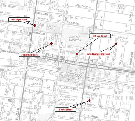
FIGURE 3 STUDENT
ACCOMMODATION QUESTIONAIRE SURVEY SITES NEAR DEAKIN UNIVERSITY
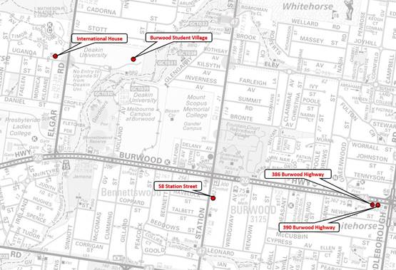
Consultation results and analysis
Snapshot of
respondents
The student
accommodation on-line survey was conducted between 30 April and 20 May 2018. A
total of 82 respondents completed the on-line survey. Of these:
· 91%
or 75 respondents indicated that they were a student.
· 72%
of student respondents were Australian citizens.
· 41%
or 31 respondents indicated that they lived in Whitehorse.
· 79%
of all survey respondents were aged between 15-24 years.
· 82%
of respondents were undergraduate students and the two most commonly
represented campuses from survey respondents were Deakin Burwood and Box Hill
Institute.
Cost of accommodation and location
(43% and 48% of respondents respectively) were the two predominant reasons why
students chose to live in their current accommodation. When students were asked
about ways that their accommodation could be improved 34% of respondents left
the question blank or stated there was nothing they would change. The most
common responses to how student accommodation could be improved were associated
with ‘making it more affordable (17%), having ‘more space’
(5%), ‘improved cleanliness’ (5% of respondents).
Dwelling types
The survey found
that the most common type of housing that respondents lived in was ‘Share
house – renting’ accounting for 36% of respondents. This was
followed closely by students who ‘live with parents or other
family’ at 35% and ‘On-campus housing’ with 19% of
respondents.
There are a
diverse range of factors which influence the supply of these different accommodation
types, including investor inclination, land availability, perceived future
demand and planning controls. At present the more ‘managed’ student
accommodation facilities face more constraints in terms of planning controls
through the Local Policy.
Student welfare
Consultation with
external stakeholders such as the student unions and student legal services
revealed that share house landlords and rooming house operators repeatedly
breach the Residential Tenancy Act which has major implications for students,
particularly international students.
The Eastern
Community Legal Centre (ECLC) reported that in some cases international
students are specifically targeted by unscrupulous landlords and rooming house
operators. Restrictive leasing arrangements causes stress to students and these
conditions often go unreported, as international students often believe (or are
told) that any complaint may have ramifications for their visa status.
Cleanliness and maintenance issues are also of significance for students, as
raised in the Student Accommodation Survey. This is compounded by affordability
issues and the limited capacity for international students to change this
situation by finding employment due to their visa status.
The issue of
accommodation affordability was raised through the Student Accommodation Survey
by all respondents. It is a key driver of housing choice and restricts students
from living in preferred housing types. Websites that advertise share houses
and rooming houses often provide misleading information to students,
particularly international students who rely on these mediums to find housing
in the first instance. College run accommodation provides more positive
learning environments for students however often is cost prohibitive for both
international and domestic students.
It was found that
domestic students do not seem to have as many issues with their tenancy
arrangements. This is perhaps due to local students having more social networks
to rely on to find accommodation and have a greater understanding of rental
rights. However, there is a small proportion of the whole student population
who couch surf and are homeless.
While Council cannot have a direct influence
over affordability of student accommodation, the regulatory framework around
student accommodation allows Council to ensure that certain types of student
accommodation meets the various legislative requirements. Many students may not
be aware of their rights to safe and legal accommodation or that they can
report unsafe accommodation to Council.
The
review has identified that there is an opportunity to inform the student
population of Whitehorse of Council’s role and responsibility in relation
to student accommodation. This could be achieved through the development of a
‘welcome pack’ for students and suitable contacts within Council to
navigate the complex regulatory environment.
|
Student Welfare Recommendations:
|
|
· Building on Council’s current Waste
Education Program for International Students (refer below), develop a
‘Welcome to Whitehorse’ resource for students that provides
information on the standards expected of student accommodation, how to book a
hard waste collection at the end of tenancy, how to report unsafe/illegal
accommodation etc.
· The allocation of a ‘student
contact’ within Council to coordinate Council’s response to
student issues in Whitehorse and to build relationships with external
agencies such as the tertiary institutions, student housing providers,
Consumer Affairs Victoria (CAV) etc.
· Continue regular communications with
stakeholders with an interest in students including representatives from the
tertiary institutions, student housing providers and Eastern Community Legal
Centre.
|
Traffic and
transport issues
Questionnaire
(face to face) traffic and parking surveys at student accommodation facilities
were done between 2 May and 9 May 2018. There were 681 respondents in
total. The questionnaire found that public transport (36% of respondents), car
(32%) and walking (29%) were the main transport modes amongst student respondents.
Carpooling or bike riding as a transport mode represented 1% of respondents.
The survey looked at typical transport mode by place of study and found that
travel to the Box Hill Institute was made via public transport by the majority
of respondents (58%). This was followed by car travel (32%), walking (5%) and
car-pooling (5%).
Results were quite
different for students travelling to Deakin University Burwood where walking
(39% of respondents) was represented as being the most significant transport mode.
This is likely due to the proximity of on campus housing to specific places of
study. Car travel (33%) and public transport (28%) were all well represented as
transport modes used by students to Deakin University.
TABLE 2: TRAFFIC QUESTIONAIRE RESULTS
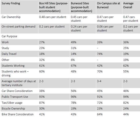
Of the survey respondents who travel by
car:
· 100%
own the car that they travel in
· 38%
park their car on the street when parking at their residence, and
· 88%
park on-site/off-street when parking at their place of study
The survey revealed
that for students who drive to their place of study, the biggest barrier to
using other transport modes is that they cannot compete on time (45%). The
other major barrier to other transport modes is distance (33%), where
presumably students feel that their housing is too far to walk or cycle to
their place of travel.
The key findings of the traffic and
transportation study were as follows:
· Student
car ownership was generally found to exceed the level of parking provided
on-site in connection with the accommodation facility.
· Across
the ten student accommodation facilities surveyed, the average on-street demand
generated was 0.2 spaces per student living at the facility.
· Overall,
the car ownership rate amongst students living at sites surveyed was 0.47 vehicles
per student.
· Timed
parking restrictions were in place on streets surrounding most of the survey
sites. These typically ceased to apply in the evening.
· Unrestricted
parking is available to varying degrees for those students prepared to park
some distance from their accommodation facility. The distances to the nearest
unrestricted parking ranged from 200m up to 1.2km.
· The
main purpose for owning a vehicle was for work (35% of respondents) followed by
study (25%) followed by daily travel (19%) and other (19%).
|
Traffic Recommendations:
|
|
· The current parking provision rates for student accommodation in
the existing policy should be maintained.
· Regular parking enforcement services should be continued through
the municipality, particularly in areas with high student populations where
there are reported issues for parking demand.
· Remove the eligibility for student accommodation facilities to
access parking permits.
· The provision of on-site car share should be considered as a
supporting measure in student accommodation developments that seek reduced
parking rates.
· Provide on-site bike share as a supporting measure in student
accommodation developments that seek reduced parking rates and include in a
management plan.
· Expand the central register of Section 173 Agreements for purpose
built accommodation to include a copy of the Management Plan for each
property and establish a regular review of management plans and inspection of
student accommodation.
|
General amenity
issues
Although waste management
was not an issue raised by respondents through the survey there are anecdotal
reports of rubbish and furniture left on roadsides that are claimed to belong
to students living in Whitehorse. In part, this problem may be attributed to
students due to the relatively short term nature of their stay in open market
rental accommodation and their need to dispose of old furniture, electronic
items and other household waste when they leave their place of residence.
However, this problem may also be attributed to population growth in general.
Claims of
unsightly or neglected premises have also been linked to the student population
in Whitehorse. Property owners are encouraged to implement a regular
maintenance program on their property to ensure grass is cut and maintained and
that footpaths and lanes are kept free of overhanging vegetation however a lack
of communication between absentee landlords, real estate agents and tenants may
contribute to the problem.
There are
penalties for dumping rubbish and failing to clear overhanging vegetation but
due to the often transient nature of students the offenders may have already
moved on before Council is made aware of the issue. The ability to purchase
cheap furniture and household goods brand new is also fueling a disposable
society regardless of being a student.
Council has a number of initiatives in
relation to waste education, some that are specifically aimed at tertiary
students. Council’s Waste Education Officer proactively recruits student
accommodation providers and known highly transient multi-unit blocks to a
scheduled monthly collection of hard waste coordinated by property managers
and/or body corporates. It is considered that a specific tool is needed to
inform students residing in Whitehorse of the availability of Council services
such as hard waste collections and advice regarding overhanging vegetation.
|
General
Amenity Recommendations
|
|
· The development of a ‘Welcome to Whitehorse’ resource
for students that provides:
Information
on how to book a hard waste collection.
Information
in relation to Council’s current waste education programs.
Information
on responsibilities of tenants in relation to overhanging vegetation.
Contact
telephone numbers for relevant Council Departments such as Local Laws.
· Advocate for the tertiary institutions and student housing
providers to promote a buy, swap, and sell for disused furniture and
household items.
|
CONSULTATION
Consultation on the Student Accommodation
Review took place from 30 April until mid-June 2018. External consultation
included:
· Updates on Council’s Student Accommodation webpage
· An on-line survey from 30 April until 20 May 2018
· Promotions on tertiary institution’s Facebook pages
· Promotions on the Whitehorse Youth ConneXions Facebook page
· Notices in the Leader Newspaper on Monday 30 April, 7 May and 14 May
2018
· Parking and traffic analysis was done through:
Parking
surveys conducted on Thursday 31 May 2018
Tube
count surveys were conducted over a seven day period from 31 May to 6th
June 2018
Questionnaire
(face to face surveys) for Burwood Student Village site 9 May 2018 and between
2nd May and 4 May for the other sites
· Meetings with:
Welfare
officers from Deakin University and Box Hill Institute
Deakin
University Legal Service,
Eastern
Community Legal Centre and
Student
Housing Australia.
The results of the
consultation are included in “Discussion” above.
A planning scheme amendment will be required
to introduce a revised Student Accommodation Policy at Clause 22.14 (refer Attachment
3, and with the policy updates shown tracked in Attachment 4). The
planning scheme amendment process will involve a period of public exhibition
which will give the community the opportunity to view the revised policy and
make a submission to Council.
FINANCIAL
IMPLICATIONS
The review of the Student
Accommodation Policy was a budget initiative in the 2017/18 financial year.
The subsequent planning scheme
amendment that would be required to introduce a revised Student Accommodation
Policy at Clause 22.14 will have associated financial considerations. These
will generally be in the form of statutory and panel hearing fees, staff costs
and costs associated with exhibition of the amendment for community comment, as
well as any costs associated with external consultants such as an expert
witness. Following is a breakdown of approximate costs:
|
Type
of Fee
|
Amount
|
|
Requesting the Minister to
prepare an amendment to a planning scheme exempted from the requirements
referred to in Section 20(4) of the Act.
|
$3,901.50
|
|
Preparation of amendment
documents by Council Officers
|
Planning officer time
|
|
Expert Witness at Panel Hearing
|
$5,000 (approx.)
|
|
Planning Panel Approximately
($7,000 per day)
|
$7,000 (approx.)
|
|
Consideration by the Minister of
a request to approve the amendment in accordance with Section 35 of the Act.
|
$469.60
|
|
Publishing Gazettal of the
Amendment in the Victorian Government Gazette and Leader Newspapers
|
$1,000 (approx.)
|
The remainder of the
recommendations primarily involve use of existing staff resources, for
advocacy, relationship development with tertiary institutions and in some
instances additional budget may be needed. A program of work can be developed
and funding sought through the Council budget process as required.
POLICY IMPLICATIONS
The Council Plan 2017 – 2021
and relevant Council strategies have all informed Council’s approach to
this review.
The review is consistent with
Strategic Direction 1 in the Council Plan which seeks to support a healthy,
vibrant, inclusive and diverse community. In particular Strategy 1.1.1 which
encourages partnership to plan and deliver high quality responsive services and
to advocate for our diverse community based on current and future needs.
Key policies in the Whitehorse
Planning Scheme that relate to student accommodation include:
Clause 16.01 Residential
Development
Clause 21.01 Municipal Profile
Clause 21.06 Housing
Clause 21.07 Economic Development
Clause 22.14 Student Accommodation
While the draft revised Student
Accommodation policy at Clause 22.14 is shown in Attachment 3, there may
be minor consequential changes to the other clauses listed above to give effect
to the outcomes of the Review.
CONCLUSION
There is currently a perception
that students living in Whitehorse contribute to a range of challenges such as
dumped rubbish, traffic and parking issues and unsightly properties. The review
recommends an educative approach to many of these issues through the
development of a ‘Welcome’ brochure for students living in Whitehorse
that provides advice on the services provided by Council. While some forms of
student accommodation may contribute to these problems, they are not
necessarily student specific, but rather a consequence of the growing
population in Whitehorse and different forms of housing.
Students are an important part of
the Whitehorse community that contribute to its diversity and economic
wellbeing. This review has highlighted the needs of students within the
Whitehorse community and how far reaching the associated issues are.
A revised Student Accommodation
Policy has been produced for Clause 22.14 of the Whitehorse Planning Scheme.
The revised policy addresses many of the planning issues in relation to student
accommodation in Whitehorse. Responsibilities for issues associated with
student accommodation lie across many departments within Council and other
external agencies. Building connections with these external agencies will be
important in the achieving a better outcome for students living in Whitehorse
and the wider community.
Attachment
1 Background
Paper ⇨ 
2 Student
Accommodation Strategy ⇨
3 Draft Revised
Policy ⇨ 
4 Draft Revised
Policy w/ tracked changes ⇨
Engineering and Environmental
9.1.3 Tender
Evaulation Report (Contract 30030) Road Improvements in Linum Street, Laurel
Grove North & Boongarry Avenue, Blackburn
SUMMARY
To consider tenders received for Road Improvements in Linum
Street, Laurel Grove North and Boongarry Avenue, Blackburn and to recommend the acceptance of the tender
received from Parkinson Group (Vic) P/L, for
the amount of $843,990.40 including GST.
|
RECOMMENDATION
That Council:
1. Accepts
the tender and signs the formal contract document for Contract 30030 for the
Road Improvements in Linum Street, Laurel Grove North and Boongarry Avenue,
Blackburn received from Parkinson Group (Vic) Pty Ltd (ABN 58 168 742 925),
of 30 Alfred Street, Blackburn Victoria 3130 for the tendered amount of
$843,990.40, including GST.
2. Resolves
that property owners pay the Declaration amount adopted by Council at its
Council meeting dated 18 July 2016 and as shown in the “Apportionment
of Costs Per Property Owner” attachment.
3. Pays all
additional costs above the amount to be contributed by property owners as
stated in recommendation 2 above.
|
BACKGROUND
Linum Street, Laurel Grove North
and Boongarry Avenue are a series of inter-connected local roads in Blackburn.
The roads are sealed with asphalt, with no formal underground drainage or kerb
and channel. They are located in a quiet suburban setting with an informal
‘leafy’ character. There is significant roadside vegetation in the
area. While not having any statutory standing, the roads are in an area
classified by the National Trust as being of Regional Landscape Significance.
The status of the roads is that
they are classified by Council as ‘unconstructed’ and therefore are
not currently listed on Council’s register of public roads, under the
Road Management Act 2004. They have never been constructed to Council’s
standards. Council’s policy is that it does not maintain unconstructed
roads throughout the municipality.
The Road Association comprising
residents from Linum Street, Laurel Grove North and Boongarry Avenue, were
finding it increasingly difficult to obtain contributions from adjacent
property owners towards the ongoing maintenance of the roads. The Road
Association had accordingly requested that Council investigate a Special Charge
Scheme to upgrade the roads to a standard acceptable by Council. Subsequently,
the investigation was carried out and the Special Charge Scheme was declared by
Council on 18 July 2016.
The Council standard for a typical
road construction is for constructed kerb and channel, underground drainage and
footpaths. However, implementing standard road construction in this area would
result in the significant loss of trees and vegetation and would change the
appearance of the roads. From the initial consultation conducted by Council,
property owners have indicated that they want to retain the informal
‘leafy’ character of the road. They are also concerned that any
formal road construction changes and vegetation removal may result in an
increase in traffic speeds and volumes.
In order to undertake any
improvement works to the roads (being a proper function of Council), it was
open to Council to declare a special charge scheme under section 163 of the Local
Government Act 1989 (‘the LGA’). A special charge scheme
declaration is a statutory process where the cost of the improvement works are
levied on, and shared by, those property owners who will derive a
‘special benefit’ from the works to be provided under the scheme.
Council at its ordinary meeting on
18 April 2016, in accordance with the provisions of section 163 of the LGA,
resolved to give notice of its intention to declare a Special Charge Scheme. On
18 July 2016 Council at its ordinary meeting resolved to declare the Special
Charge Scheme.
Following declaration of the Scheme,
Council’s engineers undertook a detailed design of the proposed road
improvements and extensive consultation with affected property owners.
DISCUSSION
Tenders were advertised in The Age
newspaper on Saturday 2 December 2017 and were closed on Wednesday 17 January
2018. One tender submission was received from Parkinson Group (Vic) Pty Ltd.
The tender was evaluated against
the following criteria:
· The
Tender Offer;
· Construction
Plan and Methodology;
· Demonstrated
Knowledge;
· Quality
of Work
· Availability
of resources
· Availability
of Tenderer; and
· Occupational
Health & Safety and Equal Opportunity (Pass/Fail).
Parkinson Group (Vic) Pty Ltd has
undertaken a number of projects for Council including the reconstruction of
McKean Street, Box Hill North and Laurel Grove North, Blackburn between The
Avenue and Fuchsia Street. These projects have been completed to a high quality
with minimal disruption to affected residents. The tender received from
Parkinson Group (Vic) Pty Ltd is considered to provide good value for money for
this Contract.
The tender submission received from
Parkinson Group (Vic) Pty Ltd indicated that their earliest start time could
be, if appropriate to Council, May 2018. Taking into account weather
considerations it was decided that an August start time was more appropriate
for this type of project.
CONSULTATION
Extensive consultation has been
undertaken over a number of years with the property owners within the Special
Charge Scheme. Following completion of the design, property owners were offered
an opportunity over several months to view the plans either at Council’s
Offices or at individual meetings on site with Council’s Project Engineer
and to provide comment on the design. A number of design changes were incorporated
as a result of property owner’s review and feedback.
Internal consultation has also been
undertaken with Council’s City Works and ParksWide Departments throughout
the design process.
The preferred tenderer’s
business viability has been considered.
Should the tender be approved and
prior to any construction works commencing, Council will notify all affected
residents of the Scheme outcome.
FINANCIAL IMPLICATIONS
The construction of Linum Street, Laurel Grove North and
Boongarry Avenue is a complicated road construction project which is not
typical of the road projects undertaken by Whitehorse City Council. There was
very low interest from contractors in undertaking this complex project. This
was evident by the non-attendance of contractors at the compulsory information
session that was organised by Council officers to provide contractors with an
understanding of works involved and the project scope. Council officers decided
to organise a second information session in order to entice contractors to
attend. Parkinson Group (Vic) Pty Ltd was the only contractor that attended the
information session.
The total value of the Special Charge Scheme declared by
Council on 18 July 2016 was $800,000. This amount comprised of a resident contribution
of $670,000 and a Council contribution towards the Scheme of $130,000.
Council’s contribution of $130,000 comprised of a $55,000 contribution
towards the Scheme for drainage improvement works and a $75,000 contribution as
an ex-gratia payment made for project management fees by Council towards the
Scheme.
Due to the complexities of this project and a lack of interest
from contractors to tender, the tendered amount for this project is higher than
the Declared Scheme cost. It is recommended that all additional costs above
those declared by Council on 18 July 2016 in the scheme, be borne by Council.
It is recommended that the balance of the project shortfall, determined to be
$43,990 be funded by Council, bringing Council’s total project contribution
to $173,990.
If there are any savings in the project, upon its completion
the total resident contribution will be reduced to reflect the final project
cost and individual property apportionments will be reduced accordingly.
|
|
Budget
|
Expenditure
|
|
Capital Works Funding Account No. V250
Linum, Laurel and Boongarry Rd SCS – (Declared)
|
$ 670,000
|
|
|
Initial Council Contribution - (Declared)
|
$ 130,000
|
|
|
Additional Council Contribution*
|
$
43,990
|
|
|
|
|
|
|
Total Budget (excl. GST)
|
$ 843,990
|
|
|
Preferred tenderer’s revised lump sum offer
(including GST)
|
|
$ 843,990
|
|
Less GST
|
|
-$
76,726
|
|
Net cost to Council
|
|
$ 767,264
|
|
PM Fees
|
|
$
76,726
|
|
Total Project Expenditure (excl. GST)
|
|
$ 843,990
|
|
|
Budget
|
Expenditure
|
* The
additional project shortfall in funding of $43,990 and any other contingencies
costs will be borne by Council.
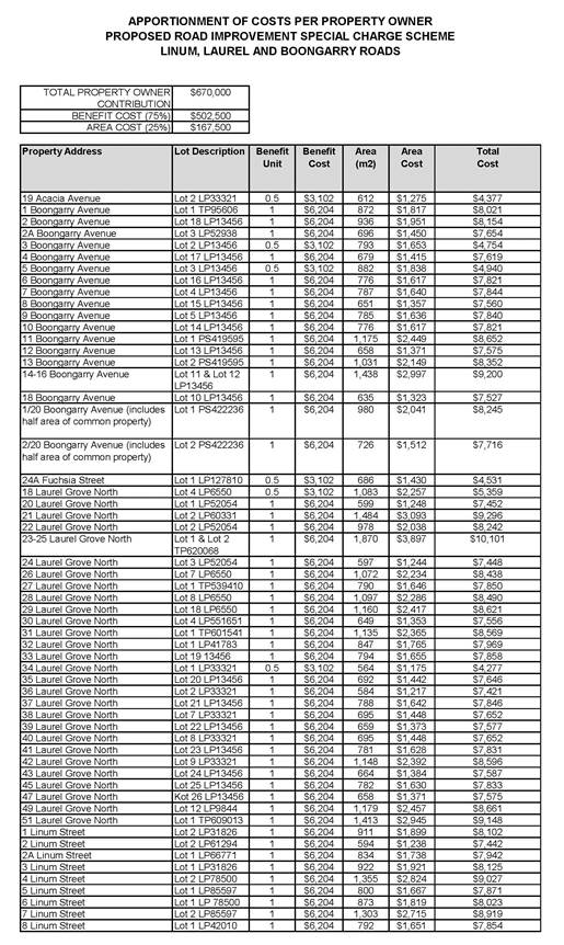
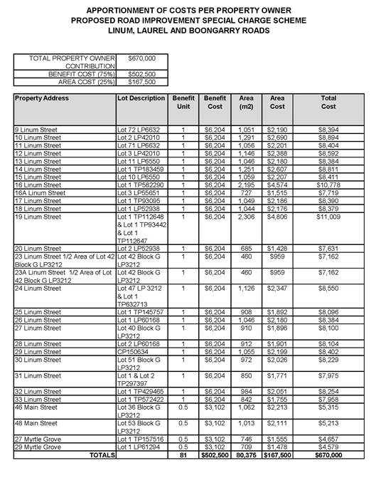
Ordinary Council Meeting 20
August 2018
9.1.4 Laneway
302 (Between 134 & 136 Canterbury Road, Blackburn South)Declaration of Road
Required for Public Use & to be Open to Public Traffic
SUMMARY
The purpose of this report is
for Council to consider the written submissions received under sections 207A(c)
and 223 of the Local Government Act 1989, the Committee report and the summary
of hearings relevant to the committee of Council which heard submitters who
wished to speak in support of their written submissions on Monday, 11 December
2017 prior to Council determining whether to declare, by resolution, that the
laneway known by Council as Laneway 302 (located between 134 and 136 Canterbury
Road, Blackburn South) is a road that is reasonably required for public use and
is to be open to public traffic. The suggested reasons for Council’s
decision are set out in the body of the recommendation below.
It is recommended that Council
declare Laneway 302 as being reasonably required for public use and is to be
open to public traffic.
|
RECOMMENDATION
That Council, having considered
all submissions received under sections 207A(c) and 223 of the Local
Government Act 1989 (LGA) (including, by a Committee of Council, having heard
persons who in their written submissions requested to be heard in support of
their submissions) and otherwise according to law hereby;
1. In
accordance with section 204(2) of the LGA and with Council being of the
opinion that the road known by Council as Laneway 302 is ‘reasonably
required for public use and is to be open to public traffic’ (road), hereby
declares that the road is ‘reasonably required for public use and is to
be open to public traffic’. (The road is located between 134 and 136
Canterbury Road, Blackburn South and is shown set aside or appropriated as a
road on plan of subdivision LP31183 lodged at the Land Titles Office on 9
August 1955).
2. In
making the declaration, Council has considered the report from the Committee
of Council that in accordance with section 223(1)(c) of the LGA had heard
persons who in their written submissions had requested to be heard. A copy of
the Committee report, being a report on the proceedings of the Committee,
including a summary of the hearings.
3. Directs
that written notice be given to all property owners and occupiers adjoining
the road, in and around the local area and to all persons who have lodged a
submission in writing of the decision of Council.
4. For
the purposes of recommendation 3, the reasons of Council for making the
declaration are that;
a) Council
considers that it is acting in accordance with the functions and powers
conferred on it under the LGA, having regard to its role, purposes and
objectives under the LGA, particularly in relation to providing and
maintaining community infrastructure in the municipal district and otherwise
performing functions in connection with the peace, order and good government
of the municipal district;
b) Council
considers that the road, based on the locality and the environment in which
the road is situated and its present and future use by the local community
(including relevant planning and development considerations), is reasonably
required for public use and should be open to public traffic;
c) Council
considers that the opening of the road will enhance or maintain land values
as well as the use, occupation and enjoyment of adjoining and other nearby
properties, and is otherwise in the public interest; and
d) Council
considers that there is minimal objection to the proposal and that there is
otherwise a sufficient level of local community support for the road to be
open to public traffic.
|
background
This report relates to the
unconstructed laneway that is referred to and known by Council as Laneway 302
(the laneway or the road). The relevant section of laneway
is located between 134 Canterbury Road and 136 Canterbury Road, Blackburn South
and is shown set aside or appropriated as a road on plan of subdivision LP31183
lodged at the Land Titles Office on 9 August 1955.
The property owner and occupier of
136 Canterbury Road have, without permission from Council, constructed a fence
that encloses a section of the laneway. The fence is for the full width of the
laneway which is 3 metres and approximately 18 metres long from the rear
boundary of 136 Canterbury Road. The fence is a paling timber fence with steel
access gates at each end. The fence blocks vehicular access through and along
the laneway.
The section of laneway that is
enclosed is shown in red on the image below.
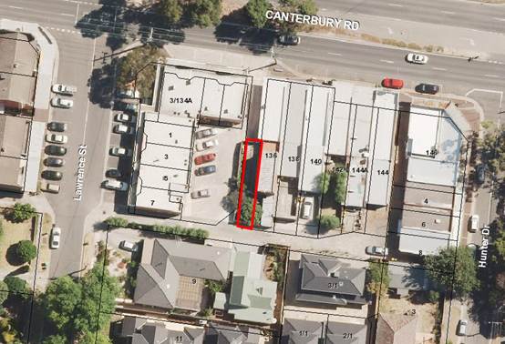
Currently, vehicles and pedestrians
wanting to have access between 134 and 136 Canterbury Road are traversing
across the car park at the rear of 134 Canterbury Road, which is private
property. The occupation of the laneway also restricts the car parking that can
be provided at the rear of 134 Canterbury Road. The fact that the laneway is
blocked means that vehicles that turn into the laneway may have to reverse out
into Canterbury Road if they cannot access through the private car park at the
rear of 134 Canterbury Road.
At its Ordinary Council meeting on
26 June 2017, Council resolved to give public notice of its intention to
declare the laneway known by Council as Laneway 302 as a road that is
reasonably required for public use and to be open to public traffic (under
section 204(2) of the Local Government Act 1989).
DISCUSSION
The status of the laneway is that
it is classified by Council as an ‘unconstructed’ road. It has not
been constructed to Council’s standards and therefore it is not
registered as a public road on Council’s register of public roads under
the Road Management Act 2004, although it nonetheless may be (and is presently
considered by Council to be) a public highway within the meaning of the Local
Government Act 1989 (LGA) and the common law (primarily based on
past usage by the public). In these circumstances, and whether or not the road
is a public highway, Council assumes no responsibility for the inspection,
repair or maintenance of such roads because Council’s current policy is
that it does not ordinarily maintain unconstructed roads throughout the
municipality.
However, and whether or not the
laneway is already a public highway, it is still considered that the laneway is
a ‘road’. This is because it is and remains shown as set aside or
appropriated as a road on plan of subdivision LP31183 lodged at the Land Titles
Office on 9 August 1955. As such, the laneway is considered to be and to remain
under the discretionary care, management and control of Council. It is
Council’s present position that all of the properties which adjoin the
road, and members of the public generally, have a lawful right to use the whole
of the road. On this basis, it is considered that the road cannot, without the
permission and authority of Council, be lawfully obstructed so as to limit,
restrict or prevent any rights of access, vehicular or pedestrian, over and
along the road.
Section 204(2) of the LGA provides
that, “A Council may, by resolution, declare a road that is reasonably
required for public use to be open to public traffic.”
It follows that, if Council is
ultimately able to form the view that the road is “reasonably required
for public use” and should be “open to public traffic”, then
Council has the power to make a declaration to this effect.
Assuming the road is not already a
public highway, the making of such a declaration by Council does not, of
itself, make the road a public highway. This means that, in the future and if
through changed circumstances, Council were to form the view that the road is
no longer “reasonably required for public use” and should no longer
be “open to public traffic”, then Council would have the power to
pass another resolution so as to give effect to this view, without the need to
commence a separate statutory process to formally discontinue the road.
CONSULTATION
On 24 October 2016 (and following
the request of some property owners of 134 Canterbury Road), Council sent a
consultation letter and survey to 43 property owners and occupiers in and
around the local area asking whether or not they supported a proposal to open
the section of the laneway that is occupied.
A total of 21 responses were
received (49% response rate), with 67% supporting the proposal, and 33%
opposing the proposal.
At its Ordinary Council meeting on
26 June 2017, Council resolved to give public notice of its intention to
declare the laneway known by Council as Laneway 302 as a road that is
reasonably required for public use and to be open to public traffic (under
section 204(2) of the LGA). The public notice was published in the Whitehorse
Leader on 14 August 2017 and sent to the property owners and occupiers in and
around the local area by letter on the same day. As part of the notice, persons
were advised they may make a written submission to Council under section 223 of
the LGA. Those making submissions could also indicate if they wish to speak in
support of their written submission (or be represented by a person on their
behalf) before a Committee established by Council for this purpose.
At the Council meeting on 26 June
2017, in accordance with section 223(1)(b)(i) of the LGA, Councillor Andrew
Munroe and Councillor Denise Massoud were appointed and authorised to be
members of the committee (‘the Committee’) to hear any
persons who in their written submissions under section 223 of the LGA have
requested that they be heard in support of their submissions.
Following the giving of public
notice and the other consultative steps taken by Council, there were two
written submissions received under section 223 of the LGA in response to
Council’s proposal to declare the road to be reasonably required for
public use and to be open to public traffic. To respect information privacy
principles, copies of the two submissions received have separately been made
available to all Councillors with their agenda papers for the Council meeting (submissions).
Council is no longer required to
make available for public inspection submissions received in accordance with
section 223 of the LGA. However, all submissions and personal information are
required to be handled as authorised or required by law, including under the Privacy
and Data Protection Act 2014.
An officer summary of the
submissions, respecting information privacy principles. Both submitters
requested to be (and were) heard in support of their submissions by the
Committee. A report on the proceedings of the Committee, and a summary of the
hearings of the Committee.
The Committee recommended that
Council proceed with the declaration. The submissions and the Committee report,
as both set out above, are provided to Council (and all Councillors) for their
further consideration. If Council decides to proceed in accordance with the
recommendation set out in this report, suggested reasons for the decision (for
adoption by Council) are set out in the body of the recommendation.
FINANCIAL
IMPLICATIONS
If approval is given to open the
laneway to public traffic, Council will subsequently take, as appropriate,
steps to require the property owner of 136 Canterbury Road to remove the
fencing and gates from around the enclosed and occupied land and obstructions
from the land, failing which Council will take such steps itself at the cost of
the property owner of 136 Canterbury Road utilising other powers available to
Council under the LGA.
Council would need to fund from its
Operational Budget the administrative and legal costs (should this matter lead
to a legal dispute between the property owner of 136 Canterbury Road and
Council) associated with the declaration and the opening of the laneway.
Council is advised that the property owner of 136 Canterbury Road may seek to
claim the occupied section of road by adverse possession and this could lead to
a legal dispute between Council and the property owner.
The cost to have the laneway
reopened to public traffic is estimated to be approximately $15,000.
9.2.1 Urban Forest
Strategy
ATTACHMENT
SUMMARY
Council has committed to the sustainable
management of trees and vegetation within the municipality. The attached
interim Urban Forest Strategy, urban Forest Policy and Tree Management Plan
outline the steps Council will take over the next two years in order to
progress that commitment.
|
RECOMMENDATION
That Council:
1. Endorse the Interim Urban Forest Strategy
2018-2020;
2. Adopt the Urban Forest Policy 2018;
3. Note that the Urban Forest Policy supersedes
the Streetscape Policy and Strategy 2002; and,
4. Note
the Tree Management Plan;
|
background
The green and leafy character of
the City of Whitehorse is one of the most common reasons cited by the community
for choosing to live in our Municipality. Further, a healthy urban forest
affords a suite of benefits for the community. To that end, Council has
endorsed through the Council plan to:
Continue to sustainably manage,
enhance and increase trees and vegetation in Council’s streetscapes,
parks and gardens, with species that enhance neighbourhood character, support
biodiversity and are adaptable to a changing climate.
Council currently manages
approximately 75,000 street trees and significant numbers of park trees. There
are also significant numbers of trees held on private land and other public
land not managed by Council. Collectively, these trees amount to a municipal
wide canopy cover of 22-26%.
Council’s tree stock is in
mixed condition with a significant portion likely to reach the end of its
useful life in the next 5-10 years.
The purpose of this Interim Urban
Forest Strategy is to:
· Outline
the strategic and operational context for the development of an Urban Forest
Strategy;
· Set
high level sustainable urban forest principles for Council to adopt;
· Outline
the key actions that Council will undertake over two to three years in order to
develop a comprehensive and scientific Urban Forest Strategy to ensure
effective and sustainable management of the urban forest into the future; and,
· Provide
an update to Council’s existing urban forest policy framework;
DISCUSSION
There are various significant
benefits for the community that can be realised by having a thriving urban
forest. These benefits include social, environmental, economic and health and
wellbeing aspects. A thriving urban forest will in particular act as an
antidote to the Urban Heat Island Effect which is a significant threat to the
health and wellbeing of residents.
In order to capitalise on these
benefits, certain criteria must be met which include:
· A
canopy cover of at least 30%;
· An
appropriate level of diversity in species resulting in resilience against
threats;
· Adequate
protection of trees; and,
· Appropriate
social conditions to encourage the community to plant and look after trees.
Successfully achieving the criteria
outlined above requires a scientific approach to the management of the urban
forest. The first stage in developing that approach is to collect and analyse
data on composition, age, health and other criteria. From that data, modelling
can occur which will allow for strategic management and maintenance of
Council’s tree population into the future. This analysis is a key aspect
of the Interim Urban Forest Strategy.
There are other actions which will
also make a significant contribution to the urban forest which are outlined in
the Interim Urban Forest Strategy. These actions are not quantified at this
stage due to the absence of complete data, but will certainly be of benefit and
include:
· Increasing
tree planting efforts;
· Improving
the protection of exiting trees;
· Improving
the health, diversity and resilience of the urban forest; and,
· Improving
and increasing community engagement.
These actions are expanded upon in
the attached Interim Urban Forest Strategy and will be implemented to some
extent between 2018 and 2021.
A more comprehensive UFS will be
developed over that time frame and will be presented to Council in the 2020-21
financial year.
Council’s Streetscape Policy
and Strategy (2002) has been the guiding document for tree related matters in
the municipality since its adoption. An updated Urban Forest Policy and Tree
Management Plan have been developed and presented to Council for adoption.
These documents have been developed
based on the 2002 policy and provide a more contemporary and streamlined basis
for the management of Council trees. Council should note that this policy does
not apply to trees on private land which are being addressed through the
planning framework separately.
CONSULTATION
Internal consultation has been
carried out in the development of this strategy and a Council briefing was held
on 2 July 2018. It is not intended that public consultation be undertaken for
the interim strategy, but that public consultation will be carried out in the
development of the final strategy.
FINANCIAL
IMPLICATIONS
Initial components of the Interim
Urban Forest Strategy are funded in 2018-19 financial year and largely involve the
collection and analysis of data. Further aspects of the Interim Urban Forest
Strategy will be costed and presented to Council as New Budget Initiatives as
part of future budget processes.
POLICY
IMPLICATIONS
The attached Urban Forest Policy
replaces the existing Streetscape Policy and Strategy (2002).
Attachment
1 Urban Forestry
Strategy - 2018 ⇨ 
Ordinary Council Meeting 20
August 2018
9.2.2 Tender
Evaluation Report (Contract 30020) Construction of Nunawading Community Hub
FILE NUMBER: SF17/667
SUMMARY
To inform Council of the tender submissions received and
the evaluation process that was undertaken to reach a final decision for the
construction of the Nunawading Community Hub. To recommend the acceptance of
the tender submission received from Buxton Constructions (Vic) Pty Ltd for the
amount of $26,346,706 including GST and to further advise on the total project
cost.
|
RECOMMENDATION
That Council:
1. Appoint Buxton Constructions (Vic) Pty
Ltd, trading as Buxton Constructions (Vic) Pty Ltd ABN 93 141 994 425, Level 1, 262
Lorimer Street, Port Melbourne, Vic 3207 as the successful contractor, and sign the formal contract
document for Contract 30020 for the construction of the Nunawading Community
Hub for the amount of $26,346,706 including GST.
2. Approve an additional
$2,324,129 in funding over the approved budget of $28M to accommodate for new
costs largely associated with the existing heritage building and the
incorporation of Environmentally Sustainable Design (ESD) components to
achieve a 5 Star Green Star rating.
|
background
The former Nunawading Primary School site was
purchased in 2015 by Whitehorse City Council. Funding has been allocated in
Council’s forward capital works program for the construction of a new
Community Hub facility at the former Nunawading Primary School site to replace
two main buildings and seven outbuildings currently situated on the nearby
Silver Grove site located next to the Nunawading Railway Station. The existing primary school site
buildings have been demolished, with the exception of the main school building,
which is subject to a municipal heritage overlay.
DISCUSSION
The new Community Hub building will be owned,
managed and operated directly by Whitehorse City Council. There will be a
number of formal and non-formal user groups that will make use of the new
facility. The wider community of the City of Whitehorse will have access to the
various events held at the Community Hub and will have access to join the
various clubs and societies utlising the building. Extensive consultation has
taken place with all existing user groups throughout the design development
phases of the project and community input and consultation has also been
gathered through various media channels and a Community Information Day. This
information has provided valuable input to the appointed architects with
regards to design requirements for current and future users of the new
Community Hub.
The selection of head contractors for construction of the
Community Hub has been structured as a two stage, competitively tested, open
market process. The first stage involved the receipt of Expressions of
Interest (EOI’s) from suitably qualified and experienced builders. The
second stage resulted in a shortlist of five respondents progressing to the
Request for Tender (RFT) stage of the project.
After being pre-selected to tender for the project, two
tenderers withdrew from the RFT process due to existing workload commitments.
An invitation was then extended to the next two tenderers with the highest
rated scores obtained in the EOI process. Only one of these two tenderers
accepted the RFT and no more parties were invited from the EOI list as their
EOI submissions did not fully satisfy the expectations set out in the EOI
documents. This resulted in four respondents being invited to tender on 30 May
2018. All four tenders were lodged on Council’s e-tender portal by the
specified closing time of 3.00pm on Monday 9 July 2018.
The successful tenderer will be appointed as the head
contractor who will engage, coordinate and manage relevant sub-contractors from
other disciplines to deliver the various services necessary for the
construction of the project.
The Tenders were evaluated against the following criteria:
· Project
Methodology (Weighted Points Score)
· Financial
Benefit (Weighted Points Score)
· Resources,
Key Personnel and Relevant Experience (Weighted Points Score)
· Relevant
Green Star Experience and Compliance Management (Weighted Points Score)
· Capacity
(Weighted Points Score)
· Nominated
Subcontractors and Relevant Experience (Weighted Points Score)
· Business
Viability (Risk Based)
· Insurances
(Risk Based)
· Conflict
of Interest (Risk Based)
· Occupational
Health & Safety (Assessed at EOI stage and re-assessed for any changes in
RFT submission)
· Equal
Employment Opportunity (Assessed at EOI stage and re-assessed for any changes
in RFT submission)
· Compliance
with Contract and Specification (Risk Based)
· Proposed
Contractor’s representative, proposed Key Personnel and proposed Senior
Executive for dispute resolution purposes (Risk Based)
· Warranties
to be provided by the Contractor (Risk Based)
· Principal’s
Design Requirements (Risk Based)
· Authority
Approvals (Risk Based)
· Professional
Referees for Tenderer (Risk Based)
A comprehensive evaluation of all tender submissions was
conducted by a four member Tender Evaluation Panel (TEP) together with expert
advice received from appointed Architects fjmt, Services Engineer WSP, ESD
Consultant WSP and Quantity Surveyor Slattery Australia Pty Ltd. All
tender submissions were evaluated by the TEP and scored against the designated
evaluation criteria. Three evaluation sessions were held with the TEP and
appointed consultants to evaluate the tender submissions. Council’s
probity advisor, CT Alliance was present as required.
The TEP analysed all criteria, including the lump sum
prices, to arrive at a pre-interview consensus score. The evaluation
determined that three tenderers scored significantly higher in all
criteria. Based on this evaluation result, these three tenderers were
invited to attend the interview stage. Due to the significant difference
relating to the tenderer with the lowest score, the TEP agreed that this
tenderer would no longer be considered as a preferred contractor for this
project.
The TEP invited to interview Buxton Constructions (Vic) Pty
Ltd, Ireland Brown Constructions Pty Ltd, and Devco Project and Construction
Management Pty Ltd as the next stage of the evaluation process.
The individual TEP scores were averaged and a final
consensus score and ranking was recorded for each tender submission.
Occupational Health and Safety (OH&S) was assessed on the responses
submitted by each contractor for the essential OH&S requirements provided
on Council’s Tender Questionnaire and considered by the Evaluation Panel
to be relevant to this construction contract. Equal Employment
Opportunity was assessed on responses submitted by each contractor.
Confirmation reference checks were conducted on all respondents. Business
Viability of tenderers was assessed by Council’s agent, Corporate
ScoreCard, taking into account the current financial position and recent
trading history of tenderers.
Following the interviews, a third and final meeting was held
by the TEP to discuss the outcome and scores were re-evaluated and confirmed
and finalised. At the conclusion of the evaluation process the preferred
tenderer that offered the best value for money outcome, with an acceptable
level of risk to Council for this contract was Buxton Constructions (Vic) Pty
Ltd.
CONSULTATION
The Tender Evaluation Panel (TEP)
included the following Whitehorse City Council officers:
· Siobhan
Belmore, Head Major Projects and Buildings
· Rohan
Prathapasinghe, Senior Project Manager - Nunawading Community Hub
· Leo
Pegoli, Buildings Co-ordinator, Major Projects and Buildings
· Louise
Goodman, Senior Architect fjmt
Various Council departments were
consulted during this tender process. All tender documents and the
process adopted for awarding the contract to the preferred contractor has been
discussed with Council’s Procurement and Contracts Department. The
Finance Department has been consulted on contractor financial viability
matters.
The tender evaluation process has
been overseen by probity advisor Matt Tubb from CT Alliance, who has provided a
signoff statement attesting to the fairness and impartiality of the tender
process.
Contractual matters have been
negotiated with the recommended respondent in consultation with Maddocks
Lawyers (Maddocks) and reviewed by the TEP. Maddocks has confirmed the
negotiated outcome is consistent with Council’s requirements and the
achievement of project objectives.
All tenderers have confirmed there
are no current legal or financial matters that would impede their ability to
deliver the project.
FINANCIAL IMPLICATIONS
The total project cost of $28 million was agreed in 14
December 2015 for the design and construction of the Nunawading Community Hub
project including a CPI allowance of 3 per cent per annum for an anticipated
build date in 2017. As at the date of this report, we have now designed and
documented the building in accordance with Council requirements and
re-evaluated the total project costs to $30,324,129, some $2,324,129 over the
agreed budget.
The additional costs of $2,324,129 are largely made up of
remedial and refurbishment works to the existing heritage building and the
incorporate of ESD components into the overall building design in order to
achieve a 5 Star Green Star rating.
The landscaping and site improvement works include
developing a linkage to Tunstall Park creating a larger, continuous public open
area. The costs of these works are estimated to be $1,079,126. We recommend
consideration be given to fund this component of the works from the
Council Public Open Space Reserve, in particular from the reserve that houses
40% of contributions received that are required to be used only for development
and improvement of public open areas. If adopted, this will not constrain other
planned uses of this reserve.
In addition to the above, we recommend consideration be
given to fund the remaining $1,245,003 from the Council Development Reserve.
We note there is a significant amount of building
construction activity in Melbourne that is challenging the capacity of the
construction companies to deliver the projects in the required timeframes. The
limited capacity of the building construction companies has resulted in an
increase in construction costs of Council projects.
The project team have undertaken various value engineering
sessions throughout the design development and documentation phases to look at
alternative finishes, fixtures and fittings to achieve a more cost effective
outcome without compromising the quality and efficiency of the building.
Financial Implications Table
|
|
Silver Grove Budget
|
|
Hub Project Budget
|
|
Difference
|
|
|
|
|
|
|
|
|
PROJECT TO DATE
|
|
|
|
|
|
|
Consultants
|
$0
|
|
$870,390
|
|
|
|
Project Management
|
$0
|
|
$815,000
|
|
|
|
|
|
|
|
|
|
|
TOTAL
|
$0
|
|
$1,685,390
|
|
|
|
|
|
|
|
|
|
|
PROJECT TO COME
|
|
|
|
|
|
|
Construction Tender
|
$24,000,000
|
|
$22,697,551
|
|
-$1,302,449
|
|
Consultant Fees
|
Incl. Above
|
|
$654,610
|
|
$0
|
|
Project Management
|
Incl. Above
|
|
$635,000
|
|
$0
|
|
Furniture, Fittings & Equipment
|
Incl. Above
|
|
$800,000
|
|
$0
|
|
Authority Fees & Headworks
|
Incl. Above
|
|
$350,000
|
|
$0
|
|
Decanting & Relocation
|
Incl. Above
|
|
$100,000
|
|
$0
|
|
Heritage Building
|
$0
|
|
$884,000
|
|
$884,000
|
|
ESD Components
|
$0
|
|
$1,070,000
|
|
$1,070,000
|
|
Intersection Works
|
$0
|
|
$250,000
|
|
$250,000
|
|
Design Contingency
|
Incl. below
|
|
Expended
|
|
$0
|
|
Construction Contingency
|
$2,765,000
|
|
$1,197,578
|
|
-$1,567,422
|
|
Cost Escalation
|
$1,235,000
|
|
$0
|
|
-$1,235,000
|
|
|
|
|
|
|
|
|
TOTAL
|
$28,000,000
|
|
$30,324,129
|
|
$2,324,129
|
9.3.1 In
Principal Approval of the 2017/18 Annual Financial Statements & Performance
Statement
ATTACHMENT
SUMMARY
Council is required to complete and forward to the
Minister for Local Government its Annual Report by 30 September 2018. The
Annual Report contains audited annual financial statements and the audited
performance statement. Council cannot submit the financial statements or the
performance statement to its auditor or the Minister unless it has passed a
resolution giving its approval in principle to the financial statements and
performance statement. It is recommended that the Annual Financial Statements
and Performance Statement, be approved in principle and upon completion of the
audit forwarded to the Minister as part of the Annual Report.
|
RECOMMENDATION
That Council receive the report and that:
1. The
Annual Financial Statements and Performance Statement for 2017/18 be approved
in principle.
2. The Principal
Accounting Officer be authorised to make minor amendments to the Annual
Financial Statements and Performance Statement for 2017/18 to meet the
Victorian Auditor General’s requirements.
3. Cr Massoud and Cr
Stennett be authorised to sign the Annual Financial Statements and
Performance Statement for 2017/18.
4. The Chief Executive
Officer be authorised to sign the Annual Financial Statements and Performance
Statement for 2017/18.
5. The final audited
Annual Financial Statements and audited Performance Statement for 2017/18 be
forwarded to the Minister for Local Government as part of the Annual Report
by 30 September 2018.
6. Public notice be given
of:
a) The
availability of the report of the auditor under Section 9 of the Audit Act
1994.
b) A
meeting to be held for the purpose of discussing the Annual Report under
Section 134 of the Local Government Act 1989 at 7.00 pm on 15 October 2018.
|
BACKGROUND
The Council is required under Section 131 of the Local
Government Act 1989 to complete an annual report each year and forward it to
the Minister by 30 September 2018. The annual report comprises:
• A report of its operations during the financial year
• Audited financial statements
• Audited performance statement
• A copy of the auditor’s reports on the financial
statements and performance statement, and
• Any other matter required by the regulations.
The Council cannot submit the financial statements or the
performance statement to its auditor or the Minister unless it has passed a
resolution giving its approval in principle to the financial statements and
performance statement.
The financial statements and
performance statement are required to be certified by Council’s Principal
Accounting Officer, by two Councillors on behalf of Council and the Chief
Executive Officer prior to Council’s Auditor signing the Audit Report.
The annual report is then required to be forwarded to the Minister for Local Government
by 30 September 2018.
The Audit Advisory Committee, at
its meeting of 20 August 2018, discussed the annual financial statements and
performance statement with representatives of the Victorian Auditor General.
DISCUSSION
The legislation requires Council to resolve to approve in
principle the annual financial statements and performance statement prior to
these statements being forwarded to the Victorian Auditor General. The
Victorian Auditor General conducted the final phase of the audit process early
August 2018 at Council. In conjunction with the audit, the Victorian Auditor
General requires copies of Council resolutions to authorise the signing and
approval in principle of the statements.
The Audit Advisory Committee reviewed the Annual
statements, in conjunction with representatives of the Victorian Auditor
General, at its meeting held on 20 August 2018.
Certification
Two Councillors and the Chief Executive Officer are
required to sign the certification of the annual financial statements and performance
statement once clearance is obtained from the Victorian Auditor General and
after the Principal Accounting Officer has signed their certification. It is
proposed that the Councillors on the Audit Advisory Committee be authorised to
sign the certification on behalf of the Council after the necessary clearance
has been obtained. In the eventuality that there may be some late changes made
to the financial statements, it is also proposed that the approval given to the
Councillors be extended to enable them to sign the certification after these
necessary changes have been made.
After the annual report has been submitted to the Minister,
Council must give public notice that the annual report has been prepared and
can be inspected at the Council office - Section 134(2).
Section 134 of the Act requires a meeting to consider the
annual report. The Council must consider the annual report at a meeting of
Council. The meeting must be held as soon as practicable but within the time
required by the regulations, after the Council has sent the annual report to
the Minister.
Attachment
1 Financial
Statements – Separately Circulated at meeting
2 Performance
Statement – Separately Circulated at meeting
9.3.2 Supplementary
Valuation Quarterly Report- 1 April 2018 to 30 June 2018
FILE NUMBER: SF16/746#02
SUMMARY
This report
presents supplementary valuations undertaken and recommends adjustment of rate
records. The supplementary valuations have been carried out on properties in
accordance with Section 13DF of the Valuation of Land Act 1960.
|
RECOMMENDATION
That Council:
1. Note and
accept the supplementary valuations undertaken during the period commencing 1
April 2018 to 30 June 2018.
2. Authorise the rate records to be adjusted to take account of the
supplementary valuations returned.
|
background
This report
relates to supplementary valuations undertaken by Council in accordance with
the Valuation of Land Act 1960 for the period from 1 April 2018 to 30
June 2018.
DISCUSSION
Supplementary
valuations are conducted regularly throughout the financial year to maintain
the equity and accuracy of Council’s rating valuation base.
Supplementary
valuations are primarily due to construction, subdivision and/or planning
activities.
The supplementary
valuations undertaken are summarized in Table #1 below.
Table # 1: Supplementary
Valuations completed between: 1 April 2018 and 30 June 2018
|
Supplementary Valuation Reference
|
Number of Assessments
|
SITE VALUE
|
C.I.V.
|
N.A.V.
|
|
April 2018
|
16
|
$ 29,770,500
|
$ 33,953,500
|
$ 1,873,725
|
|
May 2018
|
2
|
$ 1,550,000
|
$ 1,720,000
|
$ 86,000
|
|
Supplementary Valuations Total
|
18
|
$ 31,320,500
|
$ 35,673,500
|
$ 1,959,725
|
CONSULTATION
The legislative
requirement for Council to complete supplementary valuations is contained
within the Valuation of Land Act 1960. All supplementary
valuations contained in this report have been undertaken in accordance with the
2016 Valuation Best Practice Specifications Guidelines.
FINANCIAL
IMPLICATIONS
The total change
to the Capital Improved Value (CIV) caused by the supplementary valuations
undertaken is an increase of $8,341,000.
This change in CIV
has generated an additional $5,709 of
supplementary rate income.
Total year rates
income from supplementary valuations in 2017/2018 has been $1,131,137. (Note: This total includes a minor correction
reducing the previously reported rates income in the October Quarterly
Supplementary Valuation Report from $588,822 to $588,586.)
A summary of
Council’s valuation totals for all rateable properties and non-rateable
properties are set out below in Table #2, Table #3 and Table #4.
Table #2: Valuation
totals as at 1 April 2018
|
BREAKDOWN
|
Number of assessments
|
SITE VALUE
|
C.I.V.
|
N.A.V.
|
|
Rateable
|
73,436
|
$47,471,095,200
|
$65,467,656,000
|
$ 3,382,649,650
|
|
Non Rateable
|
1,074
|
$3,104,237,500
|
$3,515,477,000
|
$199,903,350
|
|
Municipal Total
|
74,510
|
$50,575,332,700
|
$68,983,133,000
|
$3,582,553,000
|
Table#3 Change
to valuation totals due to supplementary valuations between: 1 April 2018 to 30
June 2018
|
Supplementary Valuations
|
Number of assessments subject to
Supplementary Valuation
|
Change to Site
Value
|
Change to CIV
|
Change to NAV
|
|
April and May
|
18
|
$ 8,864,000
|
$ 8,341,000
|
$217,625
|
Table #4: Valuation
totals as at 30 June 2018
|
NEW BREAKDOWN
|
Number of assessments
|
SITE VALUE
|
C.I.V.
|
N.A.V.
|
|
New Rateable
|
73,431
|
$47,487,258,200
|
$65,482,718,000
|
$3,383,387,350
|
|
New Non Rateable
|
1,074
|
$3,096,938,500
|
$3,508,756,000
|
$199,383,275
|
|
New Municipal Total
|
74,505
|
$50,584,196,700
|
$68,991,474,000
|
$3,582,770,625
|
NB:
Supplementary valuations on non-rateable properties are recorded on
Council’s rating system and their totals are included in the
supplementary valuation reports. This is because non-rateable properties
may incur a Fire Service Property Levy in accordance with the Fire Services
Property Levy Act 2012.
POLICY IMPLICATIONS
The Valuations have been undertaken
in accordance with the legislative requirements of the Valuation of Land Act
1960.
9.3.3 Adoption
of Instrument of Appointment and Authorisation under the Planning and
Environment Act 1987
SUMMARY
The purpose of this report is to
recommend approval of Instrument of Appointment and Authorisation under the
Planning and Environment Act 1987, from the Council to positions in the
organisation.
|
RECOMMENDATION
That Council approve the proposed appointment of
authorised officers pursuant to the Planning and Environment Act 1987 as
attached to this report.
|
background
The proposed Instrument of
Appointment and Authorisation (pursuant to the Planning and Environment Act
1987) has been prepared following advice received from Council’s
solicitors Maddocks and is similar to that used by many Victorian
municipalities.
The Instrument of Appointment and
Authorisation allows Council officers to conduct their normal business in
relation to enforcement of the Planning and Environment Act 1987 and to
act and commence proceedings in Council’s name.
These appointments
must be made by resolution of the Council; section 3(6) of the Local
Government Act 1989 defines ‘resolution of the council’ as
including a power exercised under delegation (ie: by the Chief Executive
Officer), however section 188 (2) (c) of the Planning and Environment Act
1987 prohibits authorisations being made under delegation.
The Instruments of Appointment and
Authorisation would come into force once the common seal is affixed to the
Instrument.
CONSULTATION
Relevant staff including General
Manager City Development, Manager Planning and Building and Assistant Manager
Statutory Planning were consulted during the preparation of the proposed
Instrument of Appointment and Authorisation.
FINANCIAL
IMPLICATIONS
There are no financial
implications.
POLICY IMPLICATIONS
There are no policy implications.
Whitehorse
City Council
Instrument
of Appointment and Authorisation under the Planning and Environment Act 1987
|
STAFF
|
|
Surname
|
Given
name
|
|
Ponza
|
Elvio
|
|
Bothma
|
Gert
|
Instrument of Appointment and Authorisation
(Planning and Environment Act 1987)
In this
instrument "officer" means:
a) Elvio Ponza
b) Gert Bothma
By this
instrument of appointment and authorisation Whitehorse City Council:
a) Under section 147(4) of the Planning
and Environment Act 1987 - appoints the officer(s) to be an
authorised officer(s) for the purposes of the Planning and Environment Act
1987 and the regulations made under that Act; and
b) Under section 232 of the Local
Government Act 1989 authorises the officer(s) generally to institute
proceedings for offences against the Acts and regulations described in this
instrument.
It is declared that
this instrument -
a) Comes into force immediately upon its
execution; and
b) Remains
in force until varied or revoked.
This
instrument is authorised by a resolution of the Whitehorse City Council on
20 August 2018
|
THE
COMMON SEAL OF THE WHITEHORSE CITY COUNCIL was hereunto affixed
this day of August 2018
in the
presence of:
______________________
Councillor
______________________
Chief
Executive Officer
|
)
)
)
)
)
)
)
)
)
)
)
)
|
Ordinary Council Meeting 20
August 2018
9.3.4 Delegated
Decisions June 2018
SUMMARY
The following activity was undertaken by officers under
delegated authority during June 2018.
|
RECOMMENDATION
That the report of decisions made by officers under
Instruments of Delegation for the month of June 2018 be noted.
|
|
DELEGATION
|
FUNCTION
|
Number for June 2017
|
Number for June 2018
|
|
Planning and Environment Act
1987
|
Delegated Decisions
|
130
|
149
|
|
Strategic Planning Decisions
|
Nil
|
0
|
|
Telecommunications Act 1997
|
|
Nil
|
Nil
|
|
Subdivision Act 1988
|
|
29
|
27
|
|
Gaming Control Act 1991
|
|
Nil
|
0
|
|
Building Act 1993
|
Dispensations & Applications to
Building Control Commission
|
75
|
64
|
|
Liquor Control Reform Act 1998
|
Objections and Prosecutions
|
1
|
3
|
|
Food Act 1984
|
Food Act Orders
|
8
|
1
|
|
Public Health & Wellbeing
Act 2008
|
Improvement /
Prohibition Notices
|
6
|
2
|
|
Local Government Act 1989
|
Temporary Road Closures
|
8
|
3
|
|
Other Delegations
|
CEO Signed Contracts between $150,000 - $500,000
|
Nil
|
Nil
|
|
Property Sales and Leases
|
14
|
4
|
|
Documents to which Council seal affixed
|
Nil
|
Nil
|
|
Vendor Payments
|
1395
|
1139
|
|
Parking Amendments
|
11
|
4
|
|
Parking Infringements written off (not
able to be collected)
|
226
|
228
|
DELEGATED DECISIONS MADE ON PLANNING APPLICATIONS MAY
2018
All decisions are the subject of conditions which may
in some circumstances alter the use of development approved, or specific
grounds of refusal is an application is not supported.
|
Appl
No.
|
Date
|
Decision
|
Street Address
|
Ward
|
Proposed Use or
Development
|
Appl
Type
|
|
WH/2018/145
|
15-06-18
|
Application
Lapsed
|
1
Laurencia Court Mont Albert Vic 3127
|
Elgar
|
Construction
of a double storey dwelling to the rear of an existing dwelling in a Heritage
Overlay
|
Multiple Dwellings
|
|
WH/2011/1009/A
|
18-06-18
|
Delegate
Approval - S72 Amendment
|
1/12
Metropolitan Avenue Nunawading Vic 3131
|
Springfield
|
Buildings
and works for extension and alteration to existing trade supplies and
restricted retail premises, and provision of parking to the satisfaction of
the Responsible Authority, and associated signage.
|
Permit Amendment
|
|
WH/2012/538/A
|
06-06-18
|
Delegate
Approval - S72 Amendment
|
2
Maria Avenue Nunawading Vic 3131
|
Springfield
|
Amendments
to plans and permit WH/2012/538 for the Construction of two (2) side-by-side
double storey dwellings.
|
Permit Amendment
|
|
WH/2014/139/A
|
22-06-18
|
Delegate
Approval - S72 Amendment
|
469
Middleborough Road
Box Hill North Vic 3129
|
Elgar
|
Amendment
to plans for Planning Permit WH/2014/139 issued for the construction of one
(1) single storey dwelling to the rear of the existing dwelling to include
construction of a verandah (Lot 2)
|
Permit Amendment
|
|
WH/2014/386/A
|
18-06-18
|
Delegate
Approval - S72 Amendment
|
1/372-394
Whitehorse Road Nunawading Vic 3131
|
Springfield
|
Amendment
to Conditions 4 and 5
|
Permit Amendment
|
|
WH/2014/423/B
|
15-06-18
|
Delegate
Approval - S72 Amendment
|
15
Peel Street Mitcham Vic 3132
|
Springfield
|
Construction
of two double storey dwellings
|
Permit Amendment
|
|
WH/2014/562/A
|
27-06-18
|
Delegate
Approval - S72 Amendment
|
6
Cypress Avenue Burwood Vic 3125
|
Riversdale
|
Timber
fence added to the front of both properties within 4m of three protected
trees.
|
Permit Amendment
|
|
Appl
No.
|
Date
|
Decision
|
Street Address
|
Ward
|
Proposed Use or
Development
|
Appl
Type
|
|
WH/2015/131/A
|
01-06-18
|
Delegate
Approval - S72 Amendment
|
260
Burwood Highway Burwood Vic 3125
|
Riversdale
|
Construction
of a part four, part five storey building comprising 43 dwellings plus two
levels of basement parking, a reduction in car parking and alteration of
access to a road in a Road Zone Category 1
|
Permit Amendment
|
|
WH/2015/950/A
|
21-06-18
|
Delegate
Approval - S72 Amendment
|
3-5
Starling Street Burwood Vic 3125
|
Riversdale
|
Use
and development of a two storey child care centre and reduction of car
parking requirements
|
Permit Amendment
|
|
WH/2016/1020/A
|
28-06-18
|
Delegate
Approval - S72 Amendment
|
17
Middlefield Drive Blackburn North Vic 3130
|
Central
|
The
construction of two double storey dwellings and the construction of a front
fence within 4 metres of vegetation.
|
Permit Amendment
|
|
WH/2016/267/A
|
21-06-18
|
Delegate
Approval - S72 Amendment
|
78
Middleborough Road Burwood East Vic 3151
|
Riversdale
|
Subdivision
of land into four superlots, creation of access to roads in a Road Zone
Category 1 and variation of part Easement E-2 on PS347288N
|
Permit Amendment
|
|
WH/2016/267/B
|
21-06-18
|
Delegate
Approval - S72 Amendment
|
78
Middleborough Road Burwood East Vic 3151
|
Riversdale
|
Subdivision
of land into four superlots, creation of access to roads in a Road Zone
Category 1 and variation of part Easement E-2 on PS347288N
|
Permit Amendment
|
|
WH/2016/415/A
|
21-06-18
|
Delegate
Approval - S72 Amendment
|
78
Middleborough Road Burwood East Vic 3151
|
Riversdale
|
Creation
and alteration of access to roads in a road Zone Category 1
|
Permit Amendment
|
|
WH/2017/124/A
|
18-06-18
|
Delegate
Approval - S72 Amendment
|
49
Warrigal Road Surrey Hills Vic 3127
|
Riversdale
|
Construction
of two double storey dwellings
|
Permit Amendment
|
|
WH/2017/26/A
|
05-06-18
|
Delegate
Approval - S72 Amendment
|
8
Bruce Street Mitcham Vic 3132
|
Springfield
|
The
construction of four (4) double storey dwellings (in a General Residential
Zone and a Heritage Overlay), and the demolition of an existing dwelling and
outbuilding in a Heritage Overlay
|
Permit Amendment
|
|
Appl
No.
|
Date
|
Decision
|
Street Address
|
Ward
|
Proposed Use or
Development
|
Appl
Type
|
|
WH/2017/325/A
|
19-06-18
|
Delegate
Approval - S72 Amendment
|
1
Salisbury Avenue Blackburn Vic 3130
|
Central
|
Amendment
to Planning permit WH/2017/325 (Buildings and works, a reduction in the car
parking requirements of Clause 52.06, waiver of the loading bay requirements
of Clause 52.06 and allow for the the sale and consumption of liquor
associated with the as of right use of land for a restaurant (cafe)) to
include an extension of cafe trading hours and liquor licence hours
|
Permit Amendment
|
|
WH/2017/640/A
|
18-06-18
|
Delegate
Approval - S72 Amendment
|
14
Larch Street Blackburn Vic 3130
|
Central
|
Construction
of a double storey dwelling (within Special Building Overlay)
|
Permit Amendment
|
|
WH/2017/1018
|
01-06-18
|
Delegate
NOD Issued
|
26
Beverley Crescent Blackburn Vic 3130
|
Central
|
The
construction of two (2) double storey dwellings, buildings and works within 4
metres of vegetation and vegetation removal.
|
Multiple Dwellings
|
|
WH/2017/1048
|
01-06-18
|
Delegate
NOD Issued
|
15
Simpson Street Mitcham Vic 3132
|
Springfield
|
Construction
of two double storey dwellings, vegetation removal and buildings and works
within 4 metres of trees under the SLO9
|
Multiple Dwellings
|
|
WH/2017/107
|
18-06-18
|
Delegate
NOD Issued
|
65
Broughton Road Surrey Hills Vic 3127
|
Riversdale
|
Construction
of two double storey dwellings, front fence and tree removal
|
Multiple Dwellings
|
|
WH/2017/276
|
12-06-18
|
Delegate
NOD Issued
|
10
Leonard Street Burwood Vic 3125
|
Riversdale
|
Construction
of two (2) double storey dwellings
|
Multiple Dwellings
|
|
WH/2017/43
|
22-06-18
|
Delegate
NOD Issued
|
8
Beacon Street Vermont South Vic 3133
|
Morack
|
Development
of the land for the construction of two double storey dwellings (side by
side) and buildings and works (SLO9)
|
Multiple Dwellings
|
|
Appl
No.
|
Date
|
Decision
|
Street Address
|
Ward
|
Proposed Use or
Development
|
Appl
Type
|
|
WH/2017/691
|
05-06-18
|
Delegate
NOD Issued
|
34
Williamson Road Mont Albert North Vic 3129
|
Elgar
|
The
construction of two double storey dwellings, vegetation (tree) removal and
works within 4 metres of a protected tree (VPO2 and SLO9).
|
Multiple Dwellings
|
|
WH/2017/754
|
25-06-18
|
Delegate
NOD Issued
|
27
Walwa Street Mitcham Vic 3132
|
Springfield
|
Construction
of two double storey dwellings
|
Multiple Dwellings
|
|
WH/2017/798
|
21-06-18
|
Delegate
NOD Issued
|
119
Esdale Street Nunawading Vic 3131
|
Springfield
|
Construction
of Three (3) Double Storey Dwellings on a Lot and Removal of Vegetation
within a Significant Landscape Overlay - Schedule 9
|
Multiple Dwellings
|
|
WH/2017/800
|
12-06-18
|
Delegate
NOD Issued
|
6
Calcutta Street Mitcham Vic 3132
|
Springfield
|
Construction
of Two (2) Double Storey Dwellings and vegetation removal
|
Multiple Dwellings
|
|
WH/2017/859
|
05-06-18
|
Delegate
NOD Issued
|
121
Mount Pleasant Road Nunawading Vic 3131
|
Springfield
|
Development
of two double storey dwellings, tree removal and buildings and works
within 4m of protected trees.
|
Multiple Dwellings
|
|
WH/2017/920
|
22-06-18
|
Delegate
NOD Issued
|
71
Station Street Burwood Vic 3125
|
Riversdale
|
Proposed
buildings and works (Cool room and freezer room) and reduction of carparking
requirement in association with a restaurant
|
Business
|
|
WH/2017/924
|
14-06-18
|
Delegate
NOD Issued
|
11
Scott Grove Burwood Vic 3125
|
Riversdale
|
The
construction of a double storey dwelling at the rear of the existing dwelling
and vegetation removal.
|
Multiple Dwellings
|
|
WH/2017/938
|
18-06-18
|
Delegate
NOD Issued
|
23
Cairo Road Mont Albert North Vic 3129
|
Elgar
|
Construction
of two double storey dwellings on a lot
|
Multiple Dwellings
|
|
WH/2017/956
|
26-06-18
|
Delegate
NOD Issued
|
6
Sweetland Road Box Hill Vic 3128
|
Elgar
|
Construction
of three (3) double storey dwellings & vegetation removal
|
Multiple Dwellings
|
|
Appl
No.
|
Date
|
Decision
|
Street Address
|
Ward
|
Proposed Use or
Development
|
Appl
Type
|
|
WH/2017/958
|
29-06-18
|
Delegate
NOD Issued
|
68
Springvale Road Nunawading Vic 3131
|
Springfield
|
Development
of the land for the construction of 3 double storey dwellings, buildings and
works (SLO9), tree removal and relocation of the existing crossover in a Road
Zone - Category 1
|
Multiple Dwellings
|
|
WH/2017/963
|
29-06-18
|
Delegate
NOD Issued
|
6
Coppin Close Mitcham Vic 3132
|
Springfield
|
Construction
of four (4) double storey dwellings and removal of trees in SLO9
|
Multiple Dwellings
|
|
WH/2017/980
|
18-06-18
|
Delegate
NOD Issued
|
12-14
Varman Court Nunawading Vic 3131
|
Springfield
|
Use
the land in part for motor vehicle sales
|
Industrial
|
|
WH/2017/999
|
08-06-18
|
Delegate
NOD Issued
|
20
Scottsdale Street Surrey Hills Vic 3127
|
Riversdale
|
2
lot subdivision
|
Subdivision
|
|
WH/2018/103
|
18-06-18
|
Delegate
NOD Issued
|
1/5-7
Diana Drive Blackburn North Vic 3130
|
Central
|
The
use of the land for a food and drink premises and to serve and consume liquor
and a waiver of the standard car parking rate
|
Business
|
|
WH/2018/3
|
22-06-18
|
Delegate
NOD Issued
|
158
Elgar Road Box Hill South Vic 3128
|
Riversdale
|
Construction
of a part two and part 3 storey mixed use building to accommodate a shop and
4 x apartments and associated car parking reduction
|
Business
|
|
WH/2018/4
|
22-06-18
|
Delegate
NOD Issued
|
34
Devon Street Box Hill South Vic 3128
|
Riversdale
|
Construction
of two double storey dwellings and associated vegetation removal
|
Multiple Dwellings
|
|
WH/2014/256/B
|
18-06-18
|
Delegate
Permit Issued
|
14
Kneale Drive Box Hill North Vic 3129
|
Elgar
|
Construction
of a double storey dwelling to the rear of the existing dwelling
|
Permit Amendment
|
|
WH/2015/885/A
|
18-06-18
|
Delegate
Permit Issued
|
33
Neville Street Box Hill South Vic 3128
|
Riversdale
|
Construction
of two double storey dwellings
|
Permit Amendment
|
|
WH/2017/1005
|
25-06-18
|
Delegate
Permit Issued
|
9
Olympiad Crescent Box Hill North Vic 3129
|
Elgar
|
Construction
of two double storey dwellings and vegetation removal
|
Multiple Dwellings
|
|
Appl
No.
|
Date
|
Decision
|
Street Address
|
Ward
|
Proposed Use or
Development
|
Appl
Type
|
|
WH/2017/192
|
14-06-18
|
Delegate
Permit Issued
|
30
Station Street Burwood Vic 3125
|
Riversdale
|
Construction
of three double storey dwellings, alteration of access to a road in a Road
Zone Category 1 and buildings and works within 4 metres of a protected Tree
|
Multiple Dwellings
|
|
WH/2017/259
|
01-06-18
|
Delegate
Permit Issued
|
9
Wimmera Street Box Hill North Vic 3129
|
Elgar
|
Construction
of three double-storey dwellings and associated tree removal
|
Multiple Dwellings
|
|
WH/2017/488
|
19-06-18
|
Delegate
Permit Issued
|
1
Tudor Street Burwood Vic 3125
|
Riversdale
|
The
construction of three (3) double storey dwellings and buildings and works
within 4 metres of protected trees
|
Multiple Dwellings
|
|
WH/2017/489
|
21-06-18
|
Delegate
Permit Issued
|
60-62
Lexton Road Box Hill North Vic 3129
|
Elgar
|
Buildings
and works (refurbishing) and change of use to Motor Repairs (including
ancillary storage and offices) and display of business identification
signage.
|
Industrial
|
|
WH/2017/687
|
07-06-18
|
Delegate
Permit Issued
|
24
Clanbrae Avenue Burwood Vic 3125
|
Riversdale
|
Variation
to restrictive covenant to remove single dwelling restriction
|
Subdivision
|
|
WH/2017/834
|
14-06-18
|
Delegate
Permit Issued
|
311
Mitcham Road Mitcham Vic 132
|
Springfield
|
Alterations
and additions to a single dwelling including construction of a garage and
front fence and tree removal
|
Single Dwelling <
300m2
|
|
WH/2017/902
|
07-06-18
|
Delegate
Permit Issued
|
34
Greenwood Street Burwood Vic 3125
|
Riversdale
|
3
lot subdivision
|
Subdivision
|
|
WH/2017/949
|
08-06-18
|
Delegate
Permit Issued
|
42
Esdale Street Blackburn Vic 3130
|
Central
|
Construction
of three double storey dwellings and associated tree removal
|
Multiple Dwellings
|
|
Appl
No.
|
Date
|
Decision
|
Street Address
|
Ward
|
Proposed Use or
Development
|
Appl
Type
|
|
WH/2017/990
|
15-06-18
|
Delegate
Permit Issued
|
1050-1054
Whitehorse Road Box Hill Vic 3128
|
Elgar
|
Use
of the land as an Emergency Services Facility (Fire Station), including
associated construction of buildings and works (partial demolition,
alterations and additions to an existing building), the alteration of access
to a road located in a Road Zone, Category 1.
|
Heritage
|
|
WH/2018/106
|
12-06-18
|
Delegate
Permit Issued
|
3/51
Creek Road Mitcham Vic 3132
|
Springfield
|
Buildings
and works to construct a verandah on a lot less than 500 square metres
|
Special Landscape Area
|
|
WH/2018/110
|
08-06-18
|
Delegate
Permit Issued
|
2
Pickford Street Burwood East Vic 3151
|
Morack
|
Boundary
Realignment
|
Subdivision
|
|
WH/2018/144
|
01-06-18
|
Delegate
Permit Issued
|
470
Mitcham Road Mitcham Vic 3132
|
Springfield
|
Remove
6 trees within Schedule 9 to the Significant Landscape Overlay
|
Special Landscape Area
|
|
WH/2018/152
|
25-06-18
|
Delegate
Permit Issued
|
497
Whitehorse Road Mitcham Vic 3132
|
Springfield
|
sale
and consumption of liquor in association with a restaurant
|
Liquor Licence
|
|
WH/2018/183
|
12-06-18
|
Delegate
Permit Issued
|
347
Burwood Highway Forest Hill Vic 3131
|
Morack
|
Display
of a high-wall internally illuminated business identification panel sign and
identification of two existing signs (business identification and internally
illuminated business identification sign)
|
Advertising Sign
|
|
WH/2018/206
|
18-06-18
|
Delegate
Permit Issued
|
500
Middleborough Road Blackburn Vic 3130
|
Central
|
Removal
of three (3) trees in SLO9
|
Special Landscape Area
|
|
WH/2018/208
|
18-06-18
|
Delegate
Permit Issued
|
8
Grace Street Mont Albert Vic 3127
|
Elgar
|
Removal
of six (6) trees in the SLO9
|
Special Landscape Area
|
|
WH/2018/21
|
22-06-18
|
Delegate
Permit Issued
|
399
Springfield Road Nunawading Vic 3131
|
Springfield
|
Development
of an additional dwelling with garage and carport to existing residence
and tree removal
|
Multiple Dwellings
|
|
Appl
No.
|
Date
|
Decision
|
Street Address
|
Ward
|
Proposed Use or
Development
|
Appl
Type
|
|
WH/2018/22
|
12-06-18
|
Delegate
Permit Issued
|
545
Mitcham Road Vermont Vic 3133
|
Springfield
|
Retrospective
planning permit for an increase in the allowable hard surface and site
coverage area in SLO7 & road opening
|
Special Landscape Area
|
|
WH/2018/223
|
04-06-18
|
Delegate
Permit Issued
|
19
Devon Drive Blackburn North Vic 3130
|
Central
|
Three
lot subdivision
|
Subdivision
|
|
WH/2018/227
|
14-06-18
|
Delegate
Permit Issued
|
36
Foch Street Box Hill South Vic 3128
|
Riversdale
|
Vegetation
removal, seven trees
|
Special Landscape Area
|
|
WH/2018/231
|
01-06-18
|
Delegate
Permit Issued
|
5
Duckham Street Blackburn Vic 3130
|
Central
|
Buildings
and works within 4 metres of protected trees
|
Special Landscape Area
|
|
WH/2018/235
|
27-06-18
|
Delegate
Permit Issued
|
845-851
Whitehorse Road Box Hill Vic 3128
|
Elgar
|
Display
of advertising signage, including promotion signs and major promotion signs
|
Advertising Sign
|
|
WH/2018/243
|
12-06-18
|
Delegate
Permit Issued
|
8
Havelock Street Burwood Vic 3125
|
Riversdale
|
Three
lot subdivision
|
Subdivision
|
|
WH/2018/244
|
21-06-18
|
Delegate
Permit Issued
|
18
Cumming Street Burwood Vic 3125
|
Riversdale
|
2
Lot Subdivision
|
Subdivision
|
|
WH/2018/247
|
21-06-18
|
Delegate
Permit Issued
|
47
Mccomas Grove BURWOOD VIC 3125
|
Riversdale
|
Three
Lot Subdivision
|
Subdivision
|
|
WH/2018/248
|
21-06-18
|
Delegate
Permit Issued
|
37
Boondara Road Mont Albert North Vic 3129
|
Elgar
|
Three
lot subdivision
|
Subdivision
|
|
WH/2018/263
|
14-06-18
|
Delegate
Permit Issued
|
228/270
Canterbury Road Forest Hill Vic 3131
|
Central
|
Use
of the land for the sale and consumption of liquor
|
Liquor Licence
|
|
WH/2018/275
|
26-06-18
|
Delegate
Permit Issued
|
948
Canterbury Road Box Hill South Vic 3128
|
Riversdale
|
4
lot subdivision
|
Subdivision
|
|
WH/2018/276
|
26-06-18
|
Delegate
Permit Issued
|
33
Ashley Street Box Hill North Vic 3129
|
Elgar
|
2
lot subdivision
|
Subdivision
|
|
WH/2018/281
|
26-06-18
|
Delegate
Permit Issued
|
47
Gillard Street Burwood Vic 3125
|
Riversdale
|
subdivide
in 3 lots
|
Subdivision
|
|
WH/2018/311
|
26-06-18
|
Delegate
Permit Issued
|
116
Mahoneys Road Forest Hill Vic 3131
|
Central
|
Three
lot subdivision
|
Subdivision
|
|
WH/2018/318
|
28-06-18
|
Delegate
Permit Issued
|
4
Chaucer Street Box Hill South Vic 3128
|
Riversdale
|
Two
lot subdivision
|
Subdivision
|
|
WH/2018/327
|
05-06-18
|
Delegate
Permit Issued
|
924
Whitehorse Road Box Hill Vic 3128
|
Elgar
|
Display
advertising sign
|
VicSmart - General
Application
|
|
WH/2018/328
|
07-06-18
|
Delegate
Permit Issued
|
10
Morris Avenue Mont Albert North Vic 3129
|
Elgar
|
Buildings
and works to extend the existing dwelling
|
VicSmart - General
Application
|
|
WH/2018/344
|
29-06-18
|
Delegate
Permit Issued
|
1/29
Simpsons Road Box Hill Vic 3128
|
Elgar
|
3
LOT Subdivision In Accordance With Plan Of Subdivision - PS817819P
|
Subdivision
|
|
WH/2018/347
|
07-06-18
|
Delegate
Permit Issued
|
37
Moona Street Burwood East Vic 3151
|
Riversdale
|
Tree
Removal
|
VicSmart - General
Application
|
|
Appl
No.
|
Date
|
Decision
|
Street Address
|
Ward
|
Proposed Use or
Development
|
Appl
Type
|
|
WH/2018/354
|
29-06-18
|
Delegate
Permit Issued
|
647
Canterbury Road Vermont Vic 3133
|
Springfield
|
5
Lot residential subdivsion
|
Subdivision
|
|
WH/2018/356
|
06-06-18
|
Delegate
Permit Issued
|
29-31
Clarice Road Box Hill South Vic 3128
|
Riversdale
|
Construction
of a security gate on common property
|
VicSmart - General
Application
|
|
WH/2018/357
|
05-06-18
|
Delegate
Permit Issued
|
4
Ida Court Vermont Vic 3133
|
Morack
|
Remove
one tree
|
VicSmart - General
Application
|
|
WH/2018/363
|
29-06-18
|
Delegate
Permit Issued
|
31-33
Byron Street Box Hill South Vic 3128
|
Riversdale
|
Construction
of four double storey dwellings
|
Multiple Dwellings
|
|
WH/2018/377
|
07-06-18
|
Delegate
Permit Issued
|
1
Ireland Street Burwood Vic 3125
|
Riversdale
|
Display
of business identification signage
|
Advertising Sign
|
|
WH/2018/41
|
18-06-18
|
Delegate
Permit Issued
|
G06/
55-65 Railway Road Blackburn Vic 3130
|
Central
|
Use
of land for the sale and consumption of liquor in association with a
restaurant
|
Liquor Licence
|
|
WH/2018/444
|
28-06-18
|
Delegate
Permit Issued
|
222
Canterbury Road Blackburn South Vic 3130
|
Central
|
Front
fence with 4 metres of tree
|
VicSmart - General
Application
|
|
WH/2018/449
|
13-06-18
|
Delegate
Permit Issued
|
9a
Salisbury Avenue Blackburn Vic 3130
|
Central
|
Waiver
of car parking spaces
|
VicSmart - General
Application
|
|
WH/2018/453
|
15-06-18
|
Delegate
Permit Issued
|
5
Daisy Court Box Hill North Vic 3129
|
Elgar
|
Buildings
and works (ground floor extension) in the Special Building Overlay
|
VicSmart - General
Application
|
|
WH/2018/455
|
06-06-18
|
Delegate
Permit Issued
|
3/59
O'shannessy Street Nunawading Vic 3131
|
Springfield
|
To
remove one tree
|
VicSmart - General
Application
|
|
WH/2018/456
|
08-06-18
|
Delegate
Permit Issued
|
2
Pickford Street Burwood East Vic 3151
|
Morack
|
2
lot subdivision
|
VicSmart - Subdivision
|
|
WH/2018/457
|
08-06-18
|
Delegate
Permit Issued
|
4
Pickford Street Burwood East Vic 3151
|
Morack
|
Two
lot subdivision
|
VicSmart - Subdivision
|
|
WH/2018/465
|
05-06-18
|
Delegate
Permit Issued
|
2
Stevens Road Forest Hill Vic 3131
|
Morack
|
Two
Lot Subdivision
|
VicSmart - Subdivision
|
|
WH/2018/466
|
06-06-18
|
Delegate
Permit Issued
|
24
Margaret Street Box Hill Vic 3128
|
Elgar
|
Remove
lily pilly on right side of house
|
VicSmart - General
Application
|
|
WH/2018/467
|
06-06-18
|
Delegate
Permit Issued
|
11
Chablis Crescent Vermont South Vic 3133
|
Morack
|
To
remove tree
|
VicSmart - General
Application
|
|
WH/2018/468
|
06-06-18
|
Delegate
Permit Issued
|
12
Goodwin Street Blackburn Vic 3130
|
Central
|
removal
of tree because it is affecting all plumbing and hinders backyard development
|
VicSmart - General
Application
|
|
WH/2018/472
|
12-06-18
|
Delegate
Permit Issued
|
5
Adele Street Vermont Vic 3133
|
Springfield
|
Remove
significant tree in close proximity to proposed retaining wall building
platform and dwelling
|
VicSmart - General
Application
|
|
Appl
No.
|
Date
|
Decision
|
Street Address
|
Ward
|
Proposed Use or
Development
|
Appl
Type
|
|
WH/2018/474
|
15-06-18
|
Delegate
Permit Issued
|
15
Fithie Street Blackburn North Vic 3130
|
Central
|
Construction
of a fence within 4 metres of a protected tree
|
VicSmart - General
Application
|
|
WH/2018/475
|
19-06-18
|
Delegate
Permit Issued
|
40
High Street Nunawading Vic 3131
|
Springfield
|
Build
a front fence within 4m of protected tree
|
VicSmart - General
Application
|
|
WH/2018/476
|
07-06-18
|
Delegate
Permit Issued
|
3/22
Horfield Avenue Box Hill North Vic 3129
|
Elgar
|
Removal
of washingtonia Palm. tree is damaging existing decking, has little green
foliage, provides no shade
|
VicSmart - General
Application
|
|
WH/2018/477
|
13-06-18
|
Delegate
Permit Issued
|
4
Nelson Road Blackburn North Vic 3130
|
Central
|
Removal
of one significant tree in the SLO9
|
VicSmart - General Application
|
|
WH/2018/478
|
13-06-18
|
Delegate
Permit Issued
|
395
Middleborough Road Box Hill Vic 3128
|
Elgar
|
Buildings
and works within heritage overlay
|
VicSmart - General
Application
|
|
WH/2018/479
|
07-06-18
|
Delegate
Permit Issued
|
91
Harrison Street Box Hill North Vic 3129
|
Elgar
|
Removal
of one significant tree in the SLO9
|
VicSmart - General
Application
|
|
WH/2018/48
|
22-06-18
|
Delegate
Permit Issued
|
24
Jeffery Street Blackburn Vic 3130
|
Central
|
Construction
of a new shed and removal of existing shed within 4 metres of a tree in the
SLO1
|
Other
|
|
WH/2018/480
|
12-06-18
|
Delegate
Permit Issued
|
77
Vanbrook Street Forest Hill Vic 3131
|
Morack
|
Remove
Tree 8
|
VicSmart - General
Application
|
|
WH/2018/481
|
12-06-18
|
Delegate
Permit Issued
|
77
Vanbrook Street Forest Hill Vic 3131
|
Morack
|
Remove
Tree 9
|
VicSmart - General
Application
|
|
WH/2018/482
|
12-06-18
|
Delegate
Permit Issued
|
77
Vanbrook Street Forest Hill Vic 3131
|
Morack
|
Remove
Tree 10
|
VicSmart - General
Application
|
|
WH/2018/483
|
12-06-18
|
Delegate
Permit Issued
|
77
Vanbrook Street Forest Hill Vic 3131
|
Morack
|
Remove
Tree 11
|
VicSmart - General
Application
|
|
WH/2018/484
|
12-06-18
|
Delegate
Permit Issued
|
16
Glenice Avenue Blackburn South Vic 3130
|
Riversdale
|
Tree
Removal - Flowering Gum
|
VicSmart - General
Application
|
|
WH/2018/487
|
12-06-18
|
Delegate
Permit Issued
|
36
Orchard Crescent Mont Albert North Vic 3129
|
Elgar
|
Removal
of one protected tree in the SLO9 - Tree 2
|
VicSmart - General
Application
|
|
WH/2018/488
|
12-06-18
|
Delegate
Permit Issued
|
36
Orchard Crescent Mont Albert North Vic 3129
|
Elgar
|
Removal
of one protected tree in the SLO9 - Tree 3
|
VicSmart - General
Application
|
|
WH/2018/489
|
12-06-18
|
Delegate
Permit Issued
|
36
Orchard Crescent Mont Albert North Vic 3129
|
Elgar
|
Removal
of one protected tree in the SLO9 - Tree 2
|
VicSmart - General
Application
|
|
WH/2018/491
|
13-06-18
|
Delegate
Permit Issued
|
15
Wolseley Close Mont Albert Vic 3127
|
Elgar
|
Demolition
and rebuild of an out building within a Heritage Overlay
|
VicSmart - General
Application
|
|
WH/2018/501
|
12-06-18
|
Delegate
Permit Issued
|
13
Boardman Close Box Hill South Vic 3128
|
Riversdale
|
Tree
removal - Sydney Blue Gum
|
VicSmart - General
Application
|
|
Appl
No.
|
Date
|
Decision
|
Street Address
|
Ward
|
Proposed Use or
Development
|
Appl
Type
|
|
WH/2018/502
|
18-06-18
|
Delegate
Permit Issued
|
345
Mont Albert Road Mont Albert Vic 3127
|
Elgar
|
Reduction
of the car parking requirement for an Education Centre and Arts and Craft
Centre
|
VicSmart - General
Application
|
|
WH/2018/512
|
12-06-18
|
Delegate
Permit Issued
|
9
Reid Street Box Hill North Vic 3129
|
Elgar
|
Two
lot subdivision
|
VicSmart - Subdivision
|
|
WH/2018/513
|
15-06-18
|
Delegate
Permit Issued
|
6
Howell Avenue Surrey Hills Vic 3127
|
Riversdale
|
Tree
Removal
|
VicSmart - General
Application
|
|
WH/2018/514
|
18-06-18
|
Delegate
Permit Issued
|
24
Currie Street Box Hill North Vic 3129
|
Elgar
|
Addition
of deck to rear of existing dwelling & internal alterations
|
VicSmart - General
Application
|
|
WH/2018/516
|
19-06-18
|
Delegate
Permit Issued
|
2/5
Kinkora Road Blackburn Vic 3130
|
Central
|
Buildings
and works for a dwelling extension within 4 metres of a protected tree
|
VicSmart - General
Application
|
|
WH/2018/522
|
26-06-18
|
Delegate
Permit Issued
|
12
Acacia Street Box Hill Vic 3128
|
Elgar
|
Carport
in NCO2
|
VicSmart - General
Application
|
|
WH/2018/523
|
18-06-18
|
Delegate
Permit Issued
|
7
Jessie Street Blackburn North Vic 3130
|
Central
|
Construct
carport within 4m of trees
|
VicSmart - General
Application
|
|
WH/2018/531
|
28-06-18
|
Delegate
Permit Issued
|
3
Somers Street Burwood Vic 3125
|
Riversdale
|
Modify
front fence within 4m of protected tree
|
VicSmart - General Application
|
|
WH/2018/532
|
20-06-18
|
Delegate
Permit Issued
|
30 Grange
Road Blackburn South Vic 3130
|
Riversdale
|
Removal
of one protected tree in Significant Landscape Overlay 9
|
VicSmart - General
Application
|
|
WH/2018/538
|
18-06-18
|
Delegate
Permit Issued
|
1
Rosslyn Street Blackburn South Vic 3130
|
Central
|
Construction
of deck that increases land coverage over 33% as required by SLO2
|
VicSmart - General
Application
|
|
WH/2018/539
|
26-06-18
|
Delegate
Permit Issued
|
13
Bronte Avenue Burwood Vic 3125
|
Riversdale
|
Remove
tree within Significant Landscape Overlay - Schedule 9 and Vegetation
Protection Overlay - Schedule 3
|
VicSmart - General
Application
|
|
WH/2018/540
|
21-06-18
|
Delegate
Permit Issued
|
8
Morack Road Vermont Vic 3133
|
Morack
|
Remove
tree within Significant Landscape Overlay - Schedule 9
|
VicSmart - General
Application
|
|
WH/2018/542
|
22-06-18
|
Delegate
Permit Issued
|
13
Course Close Forest Hill Vic 3131
|
Morack
|
Removal
of one protected tree in the SLO9
|
VicSmart - General
Application
|
|
WH/2018/548
|
26-06-18
|
Delegate
Permit Issued
|
5
Anthony Court Burwood East Vic 3151
|
Morack
|
Two
lot subdivision
|
VicSmart - Subdivision
|
|
WH/2018/550
|
22-06-18
|
Delegate
Permit Issued
|
65
Doncaster East Road Mitcham Vic 3132
|
Springfield
|
To
remove tree within the Significant Landscape Overlay - Schedule 9
|
VicSmart - General
Application
|
|
WH/2018/557
|
21-06-18
|
Delegate
Permit Issued
|
497
Whitehorse Road Mitcham Vic 3132
|
Springfield
|
Retrospective
carparking reduction for restaurant (use)
|
VicSmart - General
Application
|
|
Appl
No.
|
Date
|
Decision
|
Street Address
|
Ward
|
Proposed Use or
Development
|
Appl
Type
|
|
WH/2018/570
|
26-06-18
|
Delegate
Permit Issued
|
49
Mitta Street Box Hill North Vic 3129
|
Elgar
|
Remove
Tree within Significant Landscape Overlay - Schedule 9
|
VicSmart - General
Application
|
|
WH/2018/571
|
28-06-18
|
Delegate
Permit Issued
|
49
Mitta Street Box Hill North Vic 3129
|
Elgar
|
Construct
a driveway within 4m of a protected tree under the Signifcant Landscape
Overlay - Schedule 9
|
VicSmart - General
Application
|
|
WH/2018/575
|
27-06-18
|
Delegate
Permit Issued
|
4
Uralla Street Vermont Vic 3133
|
Morack
|
Removal
of one tree within Significant Landscape Overlay - Schedule 9
|
VicSmart - General
Application
|
|
WH/2018/576
|
26-06-18
|
Delegate
Permit Issued
|
1/12
Clifford Court Forest Hill Vic 3131
|
Springfield
|
Removal
of one tree with Significant Landscape Overlay - Schedule 9
|
VicSmart - General
Application
|
|
WH/2018/581
|
27-06-18
|
Delegate
Permit Issued
|
108
Parer Street Burwood Vic 3125
|
Riversdale
|
Removal
of tree within Significant Landscape Overlay - Schedule 9
|
VicSmart - General Application
|
|
WH/2018/90
|
07-06-18
|
Delegate
Permit Issued
|
171
Burwood Highway Burwood Vic 3125
|
Riversdale
|
Buildings
and works associated with the upgrade of existing restaurant, including
internally illuminated signage
|
Residential (Other)
|
|
WH/2018/95
|
21-06-18
|
Delegate
Permit Issued
|
20
Rosslyn Street Blackburn South Vic 3130
|
Central
|
Extension
to existing dwelling
|
Special Landscape Area
|
|
WH/2016/840
|
29-06-18
|
Delegate
Refusal Issued
|
144-146
Rooks Road Nunawading Vic 3131
|
Springfield
|
Use
land to sell and consume liquor and a reduction in the standard
carparking requirement for a restaurant
|
Business
|
|
WH/2017/1007
|
19-06-18
|
Delegate
Refusal Issued
|
49
Trawool Street Box Hill North Vic 3129
|
Elgar
|
Construction
of two dwellings on a lot and tree removal
|
Multiple Dwellings
|
|
WH/2017/776
|
13-06-18
|
Delegate
Refusal Issued
|
1
Irving Avenue Box Hill Vic 3128
|
Elgar
|
Removal
of Covenant and Certification
|
Other
|
|
WH/2017/816
|
15-06-18
|
Delegate
Refusal Issued
|
45
Rostrevor Parade Mont Albert North Vic 3129
|
Elgar
|
Construction
of four (4), two storey dwellings and works within 4m of protected trees and
removal of protected trees within SLO9
|
Multiple Dwellings
|
|
WH/2017/916
|
19-06-18
|
Delegate
Refusal Issued
|
21
Fellows Street Mitcham Vic 3132
|
Springfield
|
Construction
of a single dwelling on a lot less than 500m2
|
Single Dwelling <
300m2
|
|
WH/2018/428
|
01-06-18
|
Delegate
Refusal Issued
|
Lg01/
21 Queen Street Blackburn Vic 3130
|
Central
|
reduction
of required parking from 5 to 1
|
VicSmart - General
Application
|
|
Appl
No.
|
Date
|
Decision
|
Street Address
|
Ward
|
Proposed Use or
Development
|
Appl
Type
|
|
WH/2018/524
|
20-06-18
|
Delegate
Refusal Issued
|
30
Orchard Crescent Mont Albert North Vic 3129
|
Elgar
|
Tree
removal
|
VicSmart - General
Application
|
|
WH/2018/546
|
22-06-18
|
Delegate
Refusal Issued
|
16
Silverleaf Court Forest Hill Vic 3131
|
Springfield
|
Removal
of one tree within the Significant Landscape Overlay - Schedule 9 and
Vegetation Protection Overlay - Schedule 1
|
VicSmart - General
Application
|
|
WH/2018/547
|
22-06-18
|
Delegate
Refusal Issued
|
682-684
Elgar Road Box Hill North Vic 3129
|
Elgar
|
Remove
a tree within the Significant Landscape Overlay - Schedule 9
|
VicSmart - General
Application
|
|
WH/2018/578
|
26-06-18
|
Delegate
Refusal Issued
|
11
Southey Street Blackburn North Vic 3130
|
Central
|
Removal
of tree within the Significant Landscape Overlay - Schedule 9
|
VicSmart - General
Application
|
|
WH/2018/348
|
13-06-18
|
No
Permit Required
|
1/5
Campaspe Street Box Hill North Vic 3129
|
Elgar
|
covered
alfresco area (Verandah)
|
Single Dwelling <
300m2
|
|
WH/2018/393
|
19-06-18
|
No
Permit Required
|
34
Myrtle Grove Blackburn Vic 3130
|
Central
|
Remove
1 tree in SLO2
|
VicSmart - General
Application
|
|
WH/2014/197/A
|
01-06-18
|
Withdrawn
|
44
Victoria Street Box Hill Vic 3128
|
Elgar
|
Construction
of three double storey dwellings
|
Permit Amendment
|
|
WH/2017/447
|
05-06-18
|
Withdrawn
|
25
Medway Street Box Hill North Vic 3129
|
Elgar
|
Construction
of three double storey dwellings
|
Multiple Dwellings
|
|
WH/2018/270
|
13-06-18
|
Withdrawn
|
26
Daniel Street Burwood Vic 3125
|
Riversdale
|
Construction
of two (2) double storey dwellings and removal of trees
|
Multiple Dwellings
|
BUILDING
DISPENSATIONS/APPLICATIONS JUNE 2018
|
Address
|
Date
|
Ward
|
Result
|
|
15 Fithie Street, Blackburn North
|
28-06-18
|
Central
|
Consent Granted 79
|
|
19 Gay Street, Blackburn North
|
04-06-18
|
Central
|
Consent Granted 74
|
|
25 Primrose Street, Blackburn North
|
04-06-18
|
Central
|
Consent Granted 85
|
|
3 Paulette Court, Blackburn South
|
26-06-18
|
Central
|
Consent Granted 79
|
|
5 Kalang Street, Blackburn
|
28-06-18
|
Central
|
Consent Granted 76, 79
|
|
8 Bridgeford Avenue, Blackburn North
|
15-06-18
|
Central
|
Consent Granted 74, 79
|
|
14 Larch Street, Blackburn
|
13-06-18
|
Central
|
Consent Refused 79
|
|
26 Aldinga Street, Blackburn South
|
15-06-18
|
Central
|
Consent Refused 81
|
|
3 Paulette Court, Blackburn South
|
26-06-18
|
Central
|
Consent Refused 80
|
|
5 Kalang Street, Blackburn
|
28-06-18
|
Central
|
Consent Refused 77
|
|
8 Dobell Street, Blackburn South
|
21-06-18
|
Central
|
Extension of Time Approved 76, 79, 82
|
|
32 Laurel Grove North, Blackburn
|
29-06-18
|
Central
|
Report Closed 74
|
|
1/2 Ursula Street, Box Hill North
|
05-06-18
|
Elgar
|
Consent Granted 75, 79, 80, 85
|
|
11 Ferris Avenue, Box Hill North
|
04-06-18
|
Elgar
|
Consent Granted 74, 79
|
|
1153 Whitehorse Road, Box Hill
|
21-06-18
|
Elgar
|
Consent Granted 97
|
|
12 Merton Street, Box Hill
|
04-06-18
|
Elgar
|
Consent Granted 89
|
|
12 Serpentine Street, Mont Albert
|
14-06-18
|
Elgar
|
Consent Granted 89
|
|
49 Strabane Avenue, Mont Albert Nth
|
18-06-18
|
Elgar
|
Consent Granted 92
|
|
545-563 Station Street, Box Hill
|
06-06-18
|
Elgar
|
Consent Granted 116
|
|
8 Corlett Street, Mont Albert North
|
07-06-18
|
Elgar
|
Consent Granted 74
|
|
8 Moselle Street, Mont Albert North
|
18-06-18
|
Elgar
|
Consent Granted 91
|
|
27 Pendle Street, Box Hill
|
27-06-18
|
Elgar
|
Consent Refused 74
|
|
14 East Road, Vermont South
|
26-06-18
|
Morack
|
Consent Granted 89
|
|
298 Burwood Highway, Burwood East
|
29-06-18
|
Morack
|
Consent Granted 97
|
|
3 Tulkara Grove, Vermont
|
14-06-18
|
Morack
|
Consent Granted 80
|
|
6 Picolo Close, Vermont South
|
04-06-18
|
Morack
|
Consent Granted 73
|
|
19 Carrington Court, Burwood East
|
26-06-18
|
Morack
|
Consent Refused 89
|
|
23 Thornhill Drive, Forest Hill
|
28-06-18
|
Morack
|
Consent Refused 74
|
|
9 Consort Avenue, Vermont South
|
14-06-18
|
Morack
|
Consent Refused 89
|
|
13 Pembroke Street, Surrey Hills
|
27-06-18
|
Riversdale
|
Consent Granted 89
|
|
15 Banksia Street, Burwood
|
25-06-18
|
Riversdale
|
Consent Granted 91
|
|
18 Central Avenue, Burwood
|
25-06-18
|
Riversdale
|
Consent Granted 75, 80
|
|
2 Duncan Street, Box Hill South
|
14-06-18
|
Riversdale
|
Consent Granted 80
|
|
24 Duncan Street, Box Hill South
|
21-06-18
|
Riversdale
|
Consent Granted 89
|
|
3 Beech Street, Surrey Hills
|
01-06-18
|
Riversdale
|
Consent Granted 89
|
|
43 Piedmont Street, Box Hill South
|
13-06-18
|
Riversdale
|
Consent Granted 79
|
|
63 Russell Street, Surrey Hills
|
25-06-18
|
Riversdale
|
Consent Granted 74
|
|
11 Iris Street, Burwood
|
05-06-18
|
Riversdale
|
Consent Refused 79
|
|
4 Sunhill Avenue, Burwood
|
29-06-18
|
Riversdale
|
Consent Refused 74
|
|
1 Jubilee Street, Nunawading
|
15-06-18
|
Springfield
|
Consent Granted 92
|
|
23 Rosstrevor Crescent, Mitcham
|
05-06-18
|
Springfield
|
Consent Granted 76
|
|
25 Dawe Road, Mitcham
|
19-06-18
|
Springfield
|
Consent Granted 74
|
|
27 Cyprus Avenue, Nunawading
|
18-06-18
|
Springfield
|
Consent Granted 76
|
|
3 Florida Court, Mitcham
|
27-06-18
|
Springfield
|
Consent Granted 79
|
|
4 Laidlaw Court, Vermont
|
21-06-18
|
Springfield
|
Consent Granted 76
|
|
40 Lorikeet Street, Nunawading
|
19-06-18
|
Springfield
|
Consent Granted 76
|
|
41 Owen Street, Mitcham
|
21-06-18
|
Springfield
|
Consent Granted 74
|
|
53 Alwyn Street, Mitcham
|
18-06-18
|
Springfield
|
Consent Granted 74, 75, 76, 79, 80
|
|
65 Rooks Road, Mitcham
|
12-06-18
|
Springfield
|
Consent Granted 79
|
|
1 Jubilee Street, Nunawading
|
15-06-18
|
Springfield
|
Consent Refused 89
|
|
40 Lorikeet Street, Nunawading
|
19-06-18
|
Springfield
|
Consent Refused 74
|
DELEGATED
DECISIONS MADE ON STRATEGIC PLANNING MATTERS – JUNE 2018
Under the Planning and Environment Act 1987 - Nil
REGISTER
OF CONTRACTS SIGNED BY CEO DELEGATION JUNE 2018
Nil
REGISTER
OF PROPERTY DOCUMENTS EXECUTED JUNE 2018
|
Property Address
|
Document Type
|
Document Detail
|
|
Leases
|
|
|
|
657 Elgar Road, Mont Albert North
|
Lease
|
Deed of Renewal - New Lease
(1/7/18 to 30/6/22)
|
|
Land Transfers
|
|
|
|
Part of discontinued road at rear of
498 Elgar Road, Box Hill North
|
Client Authorisation for Transfer of Land
|
Sale of Discontinued Road
Section 207D Local Government Act 1989
|
|
Part of discontinued road at rear of
498 Elgar Road, Box Hill North
|
Goods Statutory Declaration
|
Duties Act 2000
|
|
Fire Services Property Levy (FSPL)
|
|
|
|
Fire Services Property Levy Quarterly
Remittance
|
Vendor Payment Authorisation Form
|
State Revenue Office
|
REGISTER OF DOCUMENTS AFFIXED
WITH THE COUNCIL SEAL – JUNE 2018
Nil
PARKING
RESTRICTIONS APPROVED BY DELEGATION JUNE 2018
Address: Buxton
Road, Mitcham: from Whitehorse Road to Tennyson Street – west side
Previously: 15 ‘Unrestricted’ parking
spaces
Now: 15
‘2-Hour, 8am to 6pm, Monday to Friday’ parking spaces
Address: Tennyson
Street, Mitcham: from Witt Street to Buxton Road –
north side
Previously: 11 ‘Unrestricted’ parking spaces
Now: 11
‘2-Hour, 8am to 6pm, Monday to Friday’ parking spaces
Address: Springvale
Road, Nunawading: from the northern boundary of
193-195 Springvale Road to 10m north of Market Street – east side
Previously: 3 ‘No
Stopping’ parking spaces
Now: 3
‘1-Hour, 9am to 6pm, Monday to Saturday’ parking spaces
Address: Whitehorse
Road, Mitcham: from 15m east of the western
boundary of 631 Whitehorse Road to 39m east of the western boundary of 631
Whitehorse Road – east side
Previously: 4 ‘No
Parking, 8am to 9:15am, School Days’ parking
spaces
Now: 4
‘No Parking, 8:30am to 9:15am & 3pm to 4pm, School Days’
parking spaces
Address: Whitehorse
Road, Mitcham: from 48m
east of the western boundary of 631 Whitehorse Road to 70m east of the western boundary of 631 Whitehorse Road – north side
Previously: 4 ‘No
Parking, 8am to 9:15am, School Days’ parking
spaces
Now: 4
‘No Parking, 8:30am to 9:15am & 3pm
to 4pm, School Days’ parking spaces
Address: Whitehorse
Road, Mitcham: from 70m
east of the western boundary of 631 Whitehorse Road to
97m east of the western boundary of 631 Whitehorse Road – north side
Previously: 4 ‘No Stopping’ parking spaces
Now: 4
‘No Stopping, 8am to 9:15am & 3pm to 4pm, School Days’ parking
spaces
Address: Whitehorse
Road, Mitcham: from 7m east of the eastern boundary
of 631 Whitehorse Road to 19m east of the eastern boundary of 631 Whitehorse
Road – north side
Previously: 2
‘5minute, 8am to 9:15am & 3pm to
4pm, School Days’ parking spaces
Now: 2
‘2-Hour, 8am to 4pm, Monday to Friday’ parking spaces
Address: Silver
Grove (OSCP), Nunawading: from Oval Way to Silver Grove – east side
Previously: 5
‘Permit Zone Meals On Wheels Only,
Monday to Friday’ parking spaces
Now: 5
‘Permit Zone Meals On Wheels Only 8am to 1pm Mon-Fri & 4-hour, 1pm to
6pm, Monday to Friday & 4-Hour, 8am to 6pm, Saturday’ parking spaces
Address: Springfield
Road, Blackburn: from eastern boundary of 134
Springfield Road to 6m east of the western boundary of Springfield Road –
south side
Previously: 1 ‘Bus
Zone’ parking space
Now: 1
‘Works Zone, 7am to 5pm, Monday to
Saturday’ parking space
VENDOR PAYMENT SUMMARY
– SUMS PAID DURING JUNE 2018
|
Date
|
Total
Issued
|
Payments
(direct debit, cheques or electronic funds transfer)
|
Transaction Type EFT/CHQ/DD
|
|
01/06/2018
|
$420.00
|
1
|
EFC
|
|
06/06/2018
|
$2,220.00
|
1
|
EFT
|
|
06/06/2018
|
$70,664.00
|
1
|
EFT
|
|
07/06/2018
|
$15,403.04
|
18
|
EFC
|
|
07/06/2018
|
$62,966.06
|
56
|
CHQ
|
|
07/06/2018
|
$344,694.55
|
32
|
EFT
|
|
07/06/2018
|
$260,967.30
|
6
|
EFT
|
|
14/06/2018
|
$7,636.42
|
11
|
EFC
|
|
14/06/2018
|
$142,324.49
|
53
|
CHQ
|
|
14/06/2018
|
$2,157,592.43
|
309
|
EFT
|
|
14/06/2018
|
$65,989.62
|
1
|
EFT
|
|
14/06/2018
|
$5,720.00
|
1
|
EFT
|
|
15/06/2018
|
$3,400.80
|
1
|
EFC
|
|
18/06/2018
|
$14,679.05
|
8
|
CHQ
|
|
19/06/2018
|
$55,950.42
|
1
|
EFT
|
|
21/06/2018
|
$3,104.77
|
12
|
EFC
|
|
21/06/2018
|
$13,012.87
|
29
|
CHQ
|
|
21/06/2018
|
$755,059.16
|
67
|
EFT
|
|
22/06/2018
|
$1,000.00
|
1
|
CHQ
|
|
27/06/2018
|
$2,524,067.76
|
1
|
EFT
|
|
29/06/2018
|
$15,298.36
|
26
|
EFC
|
|
29/06/2018
|
$221,196.15
|
63
|
CHQ
|
|
29/06/2018
|
$6,141,468.51
|
440
|
EFT
|
|
|
|
|
|
GROSS
|
$12,884,835.76
|
1139
|
|
|
|
|
|
|
Monthly
Lease Payments
|
$36,054.51
|
|
|
|
Direct
Debit Payments
|
$355,852.57
|
|
|
|
|
|
|
|
CANCELLED
PAYMENTS
|
-$9,526.50
|
-25
|
|
|
NETT
|
$13,267,216.34
|
1114
|
|
Ordinary Council Meeting 20
August 2018
10 Reports
from Delegates, Special Committee Recommendations and Assembly of Councillors
Records
10.1 Reports
by Delegates
(NB: Reports only from Councillors
appointed by Council as delegates to community organisations/committees/groups)
|
RECOMMENDATION
That
the reports from delegates be received and noted.
|
10.2 Recommendation
from the Special Committee of Council Meeting of 13 August 2018
Ordinary Council Meeting 20
August 2018
10.3 Record
of Assembly of Councillors
|
Meeting Date
|
Matter/s
Discussed
|
Councillors
Present
|
Officers Present
|
Disclosures of Conflict of Interest
|
Councillor
/Officer attendance following disclosure
|
|
25-06-18
6.30 – 7.00pm
|
Councillor Informal Briefing Session
· Notice
of Motion 111 – Risk Mitigation
· 9.1.1
12 Milne Street, Mitcham (LOT 16 LP 33530)
|
Cr Davenport (Mayor & Chair)
Cr Barker
Cr Bennett
Cr Carr
Cr Cutts
Cr Ellis
Cr Liu
Cr Massoud
Cr Munroe
Cr Stennett
|
T Wilkinson (ACEO)
J Green
M Ackland (GMCS)
P Warner
A De Fazio
S Freud
J Russell
D Seddon
|
· Cr
Stennett declared an indirect conflict of interest on residential amenity
relating to Item 9.1.1 12 Milne Street, Mitcham (Lot 16 LP 33530)
|
· Cr
Stennett having declared an indirect conflict of interest on residential
amenity relating to Item 9.1.1 12 Milne Street, Mitcham (Lot 16 LP 33530)
left the meeting at 6.40pm, returning at 6.57pm
|
|
06-08-18
3.00-4.30pm
|
Early Years Reference Group
· Whitehorse
Early Years Plan
|
Cr Liu
Cr Stennett
|
N Rogers
R Simpson
R Kalaidjian
P Heselev
M Grant
A Allen
|
Nil
|
Nil
|
|
06-08-18
6.30-9.00pm
|
Strategic Planning Session
· Capital
Works
· Community
Satisfaction Survey
· Student
Accommodation Policy Review
· Waste
Management Strategy
|
Cr Davenport (Mayor & Chair)
Cr Barker
Cr Bennett
Cr Cutts
Cr Ellis
Cr Liu
Cr Massoud
Cr Stennett
|
N Duff
J Green
N Brown
(AGMHS) D Seddon
P Smith
A De Fazio
S Hewett
C Gripps
S Cann
S Smith
K Marriott
A North
I Kostopoulos
I Barnes
M Kerr
J Nikas
|
Nil
|
Nil
|
|
13-08-18
5.30-6.00pm
|
Metropolitan Activity Centre Logo for Box
Hill, Workshop
|
Cr Davenport (Mayor & Chair)
Cr Barker
Cr Bennett
Cr Cutts
Cr Ellis
Cr Liu
Cr Massoud
|
N Duff
J Green
N Brown
(AGMHS) D Seddon
P Smith
A De Fazio
S Freud
P Moore
B Allder
W Gerhard
D Shambrook
D Vincent-Smith
|
Nil
|
Nil
|
|
13-08-18
6.30-10.00pm
|
Councillor Briefing Session
· Integrated
Water Management Strategy
· Tender
Evaluation Report (30020), Construction of Nunawading Community Hub
· Special
Committee Agenda
· Draft
Council Agenda 20 August 2018
· Other
Business
· Budget
Meetings 2019
· Valuation
Rates Notice 2018/2019
·
Annual Accounts Process
|
Cr Davenport (Mayor & Chair)
Cr Barker
Cr Bennett
Cr Cutts
Cr Ellis
Cr Liu
Cr Massoud
Cr Munroe
Cr Stennett
NB. Cr
Bennett left the meeting at 9.00pm
|
N Duff
J Green
N Brown
(AGMHS) D Seddon
P Smith
A De Fazio
S Belmore
K Marriott
A Egan
J Hansen
I Kostopoulos
S Tierney
P Moore
|
Nil
|
Nil
|
|
RECOMMENDATION
That the record of Assembly
of Councillors be received and noted.
|
11 Reports
on Conferences/Seminars Attendance
|
RECOMMENDATION
That the record of reports on
conferences/seminars attendance be received and noted.
|
12 Confidential
Reports
|
RECOMMENDATION
That in
accordance with Section 89(2) (h) and (d) of the Local Government Act 1989 the
Council should resolve to go into camera and close the meeting to the public
as the matters to be dealt with relate to any other matter which the Council
or special committee considers would prejudice the Council or any person and
contractual matters.
|
6.1 Notice
of Motion No 112 - Cr Barker
12.1 Contractual
Matter
13 Close Meeting